July 21st (Sunday) was the hottest day ever on record on planet Earth — Jeff Berardelli (@WeatherProf) #ActOnClimate

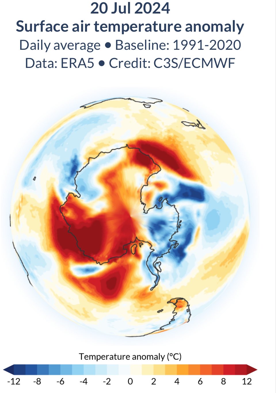
The most anomalously warm places were Antarctica and Western Canada where several hundred wildfires blaze, many out of control. July 20th pictured on the map (21st not available yet via Copernicus)

Click the link to read “Sunday was the hottest day ever recorded on Earth, scientists say” on The Washington Post website (Sarah Kaplan). Here’s an excerpt:
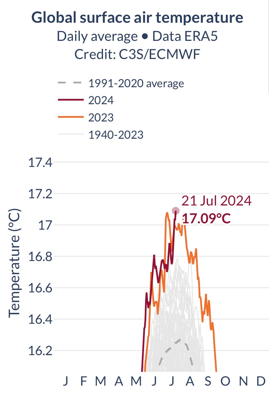
July 23, 2024

The historic day comes on the heels of 13 straight months of unprecedented temperatures and the hottest year scientists have ever seen.

Global temperatures hit the highest levels in recorded history on Sunday, according to preliminary data from Europe’s top climate monitor — another worrying sign of how human-caused climate change is pushing the planet into dangerous new territory. The results from the Copernicus Climate Change Service show the planet’s average temperature on July 21 was 17.09 degrees Celsius (62.76 degrees Fahrenheit) — breaking a record set only last year. The historic day comes on the heels of 13 straight months of unprecedented temperatures and the hottest year scientists have ever seen.

“We are in truly uncharted territory,” Copernicus director Carlo Buontempo said in a statement. “And as the climate keeps warming, we are bound to see records being broken in future months and years.”

[…]

Though Sunday was only slightly warmer than the world’s previous hottest day, Copernicus researchers noted, it was extraordinarily hotter than anything that came before. Before July 2023, Earth’s daily average temperature record  set in August 2016 — was 16.8 degrees Celsius (62.24 degrees Fahrenheit). But in the past year, the global has exceeded that old record on 57 days.

“What is truly staggering is how large the difference is between the temperature of the last 13 months and the previous temperature records,” Buontempo said.

Getches-Wilkinson Center (@CUBoulderGWC) is thrilled to host Bob Anderson, Solicitor of the Department of the Interior, for the 2024 Ruth Wright Distinguished Lecture.

Thurs, Sept 26th 6:00-7:30pm

@ColoLaw FREE and open to the public, registration is required. Registration: https://colorado.edu/center/gwc/2024/07/17/2024-ruth-wright-distinguished-lecture-natural-resources

R.I.P. Dr. Wallace J. Nichols: “I wish you water”

Click the link to read the blog post on the Wallace J. Nichols website (Dana Nichols):

July 2024

Dr. Wallace J. Nichols Memorial Foundation Update

Hello everyone,

By now, you’ve likely heard the news of J’s passing. We want to thank you for your outpouring of love and support over the past few weeks.

I also want to thank Outside Magazine for its tribute to my husband, which was published earlier this month. And Plastic Pollution Coalition, who published this blog to honor him and his work.

J dedicated his life to understanding how our connection to water and wildlife has the power to change our health and well-being. He worked tirelessly to share his findings with the world – from his best-selling book Blue Mind, to countless environmental organizations and movements that he founded and supported.

We are currently in the process of turning the Dr. Wallace J. Nichols Memorial Fund into a foundation. Our goal is to continue J’s important work, complete unfinished projects, and support causes he was passionate about, including:

  • The Blue Mind Movement reconnects people to water by linking ocean and waterway exploration, restoration, and conservation with neuroscience, psychology, public health, and well-being. This involves an annual summit, workshops, research collaborations and a small grants program through The Ocean Foundation.
  • Billion Baby Turtles Project was founded by J and Brad Nahill to increase the number of baby sea turtles in oceans around the world. To date, we have saved nearly 1 million hatchlings at nesting beaches in El Salvador, Mexico, Nicaragua, Costa Rica, and elsewhere.
  • Blue Marbles Project has a goal of passing a marble through every person’s hand on earth, with a simple message of gratitude. Since our launch in 2009, millions around the world have joined hands to create a blue global community.
  • Force Blue unites the community of Special Operations veterans with the world of marine conservation, for the betterment of both. J was deeply passionate about Force Blue’s mission and loved supporting the project with his time and energy.
  • Plastic Pollution Coalition is a non-profit communications and advocacy organization that collaborates with an expansive global alliance of organizations, businesses, and individuals to create a more just, equitable, regenerative world free of plastic pollution and its toxic impacts. J was a longtime friend and founding advisor to the Plastic Pollution Coalition.

Thank you to everyone who has contributed to the fund thus far. We are grateful for your generosity and deeply moved by your stories of J’s impact on all our lives.

If you’re interested in helping with the foundation and preserving J’s legacy, please contact me directly at legacy@wallacejnichols.org.

We wish you water,

Dana Nichols

Blue Mind can be a life-changing read, wholeheartedly recommended by Coyote Gulch.

Report: Sacket v. EPA The State of Our Waters One Year Later — ProtectCleanWater.org

Click the link to access the report on the ProtectCleanWater.org website. Here’s an excerpt:

July 2024

Introduction

One year ago, the Supreme Court issued its sweeping decision in the case Sackett v. EPA, which invalidated federal Clean Water Act protections for most streams and wetlands in the United States. Since then, the fight for clean water protections has been at the state level. This report outlines the state of clean water protections one year out from the Sackett decision and why federal protections for our critical waters is vital in the face of worsening climate change and other threats.

In the year since the Supreme Court ruling, two states passed or introduced legislation to create new permitting programs to fill the gap in federal protections and eight states passed or introduced stronger laws and policies to strengthen state protections. Two states passed legislation weakening state-level protections, while efforts to weaken state protections failed in four other states.

The Importance of Wetlands and Streams

Wetlands and streams are the livers and heart of our ecosystems. These critical waters prevent flooding, filter pollution, store carbon, and provide critical habitat for wildlife. According to the Environmental Protection Agency (EPA), ”Wetlands are among the most productive ecosystems in the world, comparable to rain forests and coral reefs.”

Similarly, streams that flow only part of the year play a critical role in maintaining the quality and supply of our drinking water and aid water conservation.

Our lakes and rivers depend on these critical waters, which in turn depend on the Clean Water Act (CWA or the Act) for protections to keep them healthy for fishing and swimming, agriculture and other business uses, and as a source for drinking water. In many cultures, particularly Indigenous cultures, water has a deep religious and spiritual element, and water is seen as life — waters are considered sacred places to cherish and protect. To limit their protection under the CWA could degrade the quality of water in waterways that people and wildlife depend on.

Healthy mountain meadows and wetlands are characteristic of healthy headwater systems and provide a variety of ecosystem services, or benefits that humans, wildlife, rivers and surrounding ecosystems rely on. The complex of wetlands and connected floodplains found in intact headwater systems can slow runoff and attenuate flood flows, creating better downstream conditions, trapping sediment to improve downstream water quality, and allowing groundwater recharge. These systems can also serve as a fire break and refuge during wildfire, can sequester carbon in the floodplain, and provide essential habitat for wildlife. Graphic by Restoration Design Group, courtesy of American Rivers

A look at the total Tornado Warnings issued by NWS office so far this year across the United States! #Tornado — @mark_tarello

$48.4M for Collaborative Efforts to Conserve America’s Most Imperiled Species: Funding will support projects under the Endangered Species Act and leverage an additional $27.75 million in partner funds — U.S. Fish and Wildlife Service #ActOnClimate

Oregon silverspot butterfly (Argynnis zerene hippolyta). Photo credit: Oregon Department of Fish & Wildlife

Click the link to read the release on the USFWS website (Marylin Kitchell):

The U.S. Fish and Wildlife Service today announced $48.4 million in grants to 19 states and Guam to support land acquisition and conservation planning projects on over 23,000 acres of habitat for 80 listed and at-risk species through the Cooperative Endangered Species Conservation Fund (CESCF). The grants will be matched by more than $27.75 million in partner funds.

“Thanks to the Endangered Species Act, this critical funding will help in conserving our nation’s most imperiled wildlife and vital habitat while fostering partnerships between federal, state and local governments, private landowners and communities,” said Service Director Martha Williams. “These grants support the Biden-Harris administration’s America the Beautiful initiative goal to conserve, connect and restore 30 percent of the Nation’s lands and waters by protecting biodiversity, slowing extinction rates and facilitating collaborative restoration efforts.”

Authorized by Section 6 of the Endangered Species Act and partly funded through the Land and Water Conservation Fund, CESCF grants contribute millions annually to support the implementation of state and territorial programs that conserve and recover federally listed and at-risk species on non-federal lands. This approach to conservation, done in cooperation with states, territories, willing landowners and local partners, furthers species conservation and facilitates compatible economic development.

CESCF land acquisition funding to states is awarded through two nationally competitive grant programs: the Recovery Land Acquisition Grant Program, which provides funds for the acquisition of habitat in support of Service-approved recovery plans, and the Habitat Conservation Plan Land Acquisition Grant Program, which provides funds to acquire habitat for listed and at-risk species to complement conservation strategies of approved HCPs. This year’s awards, totaling more than $41.4 million, will fund the acquisition and permanent protection for 21 projects over 23,000 acres of habitat across 16 states for the benefit of 40 listed and at-risk species, including the Indiana bat, wood stork, gopher tortoise, Oregon silverspot butterfly and speckled pocketbook mussel.

The Service also approved more than $6.9 million in grant awards to five states and Guam under the Conservation Planning Assistance Grant Program. Funding awarded through this program may be used to support the development, renewal or amendment of voluntary landowner agreements, i.e., HCPs and conservation benefit agreements. Eligible activities include document preparation, public outreach, baseline species surveys, habitat assessments, inventories and environmental compliance. This year’s awards will support nine conservation planning efforts covering 51 listed, candidate and at-risk species, such as the western snowy plover, Mariana fruit bat, San Joaquin kit fox and Everglade snail kite. 

For a full list of awards and to learn more about the CESCF grant programs, please visit the Service’s program page.

The ESA provides a critical safety net for North America’s native fish, wildlife and plants. The Service is working to actively engage conservation partners and the public in the search for improved and innovative ways to conserve and recover imperiled species. Learn more online about our endangered species efforts.

Snowy plover (Charadrius nivosus) at Bon Secour National Wildlife Refuge. By U.S. Fish and Wildlife Service Southeast Region – Snowy Plover (Charadrius nivosus)Uploaded by AlbertHerring, Public Domain, https://commons.wikimedia.org/w/index.php?curid=29813304

Technical Report: Regulatory and Environmental Considerations for Floating Photovoltaic Projects Located on Federally Controlled Reservoirs in the United States — NREL

FPV system sited on a non-powered reservoir Illustration by Besiki Kazaishvili, NREL

Click the link to access the report on the NREL website (Aaron Levine, Taylor L. Curtis, Ligia E.P. Smith, and Katie DeRose). Here’s the executive summary:

June 2024

Executive Summary

To meet the nation’s decarbonization goals, the U.S. Department of Energy’s Solar Futures study forecasts that installed solar photovoltaic (PV) capacity must increase nearly tenfold, from 80 gigawatts (GW) in 2020 to approximately 760 GW cumulative installed capacity by 2035 (DOE 2021). Ground-mounted PV is expected to dominate future solar deployment and will require more than 3.5 million acres of land to meet annual demand projections (of nearly 45 GW) by 2030 (DOE 2021). However, various competing demands for land (e.g., agricultural production, conservation) and high land acquisition costs in specific locations could be challenges to meeting future PV demand solely with ground-mounted PV deployment (Wood MacKenzie 2023; DOE 2021; Oliveira-Pinto and Stokkermans 2020). Floating photovoltaics (FPV) may be an alternative in locations where ground-mounted PV is not feasible and aid in reaching the nation’s PV deployment and decarbonization goals (DOE 2021; Oliveira-Pinto and Stokkermans 2020; Hooper, Armstrong, and Vlaswinkel 2020; Gallucci 2019).

FPV is a newer siting approach in which a PV array is affixed to a floating apparatus and sited on a water body like a reservoir behind a dam. FPV systems may be stand-alone or co-located a new or existing hydroelectric facilities or pumped storage hydropower (PSH) facility reservoirs. Co-located FPV systems may or may not be operationally paired and work in tandem with the hydroelectric or PSH facility (Gadzanku and Lee 2022; Gadzanku et al. 2021a, 2021b; Lee et al. 2020; Oliveira-Pinto and Stokkermans 2020; Spencer et al. 2018).

Although FPV deployment in the United States is nascent with less than 30 projects installed, significant potential has been identified at existing U.S. reservoirs (Chopra and Garasa Sagardoy 2022). A 2018 National Renewable Energy Laboratory (NREL) study identified more than 24,000 manmade reservoirs (with a total surface area of more than 2 million hectares) in the United States with technical FPV potential; the largest opportunities were found at reservoirs owned by the U.S. Army Corps of Engineers (USACE) and the Bureau of Reclamation (Reclamation). The NREL study estimated that, if fully realized, FPV systems on U.S. water bodies could have produce almost 10% of the nation’s electricity generation in 2018 (approximately 786 terawatt-hours) (Spencer et al. 2018). A follow-on study completed by NREL in 2024 identified between 861 GW and 1,042 GW (corresponding to 1,221 terawatt- hours and 1,476 terawatt-hours) of technical resource potential across USACE, Reclamation, and Federal Energy Regulatory Commission (FERC)-licensed reservoirs.

Current U.S. domestic FPV development is mostly limited to small-scale projects of less than 1 megawatt (MW) sited on closed-loop water bodies such as wastewater treatment plants, drinking water ponds, and irrigation water storage ponds (Chopra and Garasa Sagardoy 2022). Nevertheless, the versatility, potential benefits, and resource potential of FPV have led to growing investment in recent years, which is expected to continue as PV developers look to alternatives like FPV to meet growing demand (Wood MacKenzie 2023; Chopra and Garasa Sagardoy 2022).

This report provides novel analysis to understand the opportunities and challenges associated with developing stand-alone and co-located FPV projects on Reclamation reservoirs, USACE reservoirs, and FERC-licensed reservoirs in the United States. Specifically, the report explores potential environmental and energy benefits and environmental impacts associated with the siting, construction, and operation of FPV projects. The report also identifies and analyzes U.S. federal- and state-issued permits and authorizations required by federal laws to understand the licensing pathways and regulatory requirements for FPV projects sited on FERC-licensed reservoirs, Reclamation-powered and non-powered reservoirs, and USACE powered and non- powered reservoirs.

Of note, this report only analyzes the addition of FPV to reservoirs and does not consider FPV development on or above canal systems.

In #NewMexico’s Middle #RioGrande, the wheels are coming off — John Fleck (InkStain.net)

Construction crews attempt to repair the El Vado dam along the Rio Grande in New Mexico. The federal government has been unable to find a way to stop seepage behind the steel faceplate dam. U.S. Bureau of Reclamation

Click the link to read the article on the InkStain website (John Fleck):

July 15, 2024

Talking to Jake Bittle for his Grist piece on the trials and tribulations of El Vado Dam, he asked me a question I loved: “What does this mean in the larger scheme of things?”

My answer:

We seem to be living through a grand convergence of aging water infrastructure failure on New Mexico’s Middle Rio Grande this year.

We’ve talked in this space before about El Vado – built in the 1930s, unusable today. But it is only one example among many right now. If we are frank in recognizing that the main Rio Grande channel is a human artifact, dug in its current place and form in the 1950s, the list right now is long. The Flood Control Acts of 1948 (Public Law 80-858) and 1950 (Public Law 81-516) established the Middle Rio Grande Project and assigned the Bureau of Reclamation the job of performing Rio Grande channel maintenance.

Side channels were excavated by the Bureau of Reclamation along the Rio Grande where it passes through the Rhodes’ property to provide habitat for the endangered silvery minnow. (Dustin Armstrong/U.S. Bureau Of Reclamation)

The channel is infrastructure.

And it’s not just human water use that has optimized around the infrastructure. I was very careful in my comment to Jake – “entire human and natural communities” have optimized around the temporal and spatial flow of a century of altered river systems. When we taught together in the UNM Water Resources Program, my friend and collaborator Benjamin Jones spent significant time on the concept of “coupled human and natural systems”. This is that.

Here’s my current list, feel free to add your favorites in the comments.

The Rio Chama viewed from US highway 84 between Abiquiú, New Mexico, and Abiquiu Dam. By Dicklyon – Own work, CC BY-SA 4.0, https://commons.wikimedia.org/w/index.php?curid=110189310

RIO CHAMA DOWNSTREAM FROM ABIQUIU

The Army Corps of Engineers has had to curtail releases out of Abiquiu Dam on the Rio Chama because sediment has plugged the river. That means decreased flows downstream. They’re working like crazy to dig a pilot channel. It is not yet working.

CORRALES SIPHON

The Corrales Siphon, built (like El Vado) in the 1930s as part of the early Middle Rio Grande Conservancy District works is (like El Vado) broken. The district has installed temporary pumps, but with the reduced flows out of the Chama, there’s not enough water in the Rio Grande to feed the pumps, which means irrigators in Corrales have no water.

LOWER SAN ACACIA REACH

The Rio Grande’s Lower San Acacia reach, heavily altered by channel reconstruction and management from the 1950s onward, is – I believe the technical term is “a fucking mess”. It’s increasingly difficult to get water through this reach to users downstream who depend on it. Lots more on this situation here.

LOW FLOW LEAK

The Low Flow Conveyance Channel (Yay 1950s engineering!) sprang a kinda big leak the early 1990s. It’s still leaking, much to the delight of endangered willow flycatchers – to the human water users not so much.

Southwestern Willow flycatcher