The Tule River Tribe of California recruits an old ally in its fight against wildfires: Beavers — Grist

American beaver, he was happily sitting back and munching on something. and munching, and munching. By Steve from washington, dc, usa – American Beaver, CC BY-SA 2.0, https://commons.wikimedia.org/w/index.php?curid=3963858

Click the link to read the article on the Grist website (Taylar Dawn Stagner):

June 28, 2024

This story was originally published by Grist. Sign up for Grist’s weekly newsletter here.

Beavers were once abundant in North America. Bringing them back could have serious climate benefits.

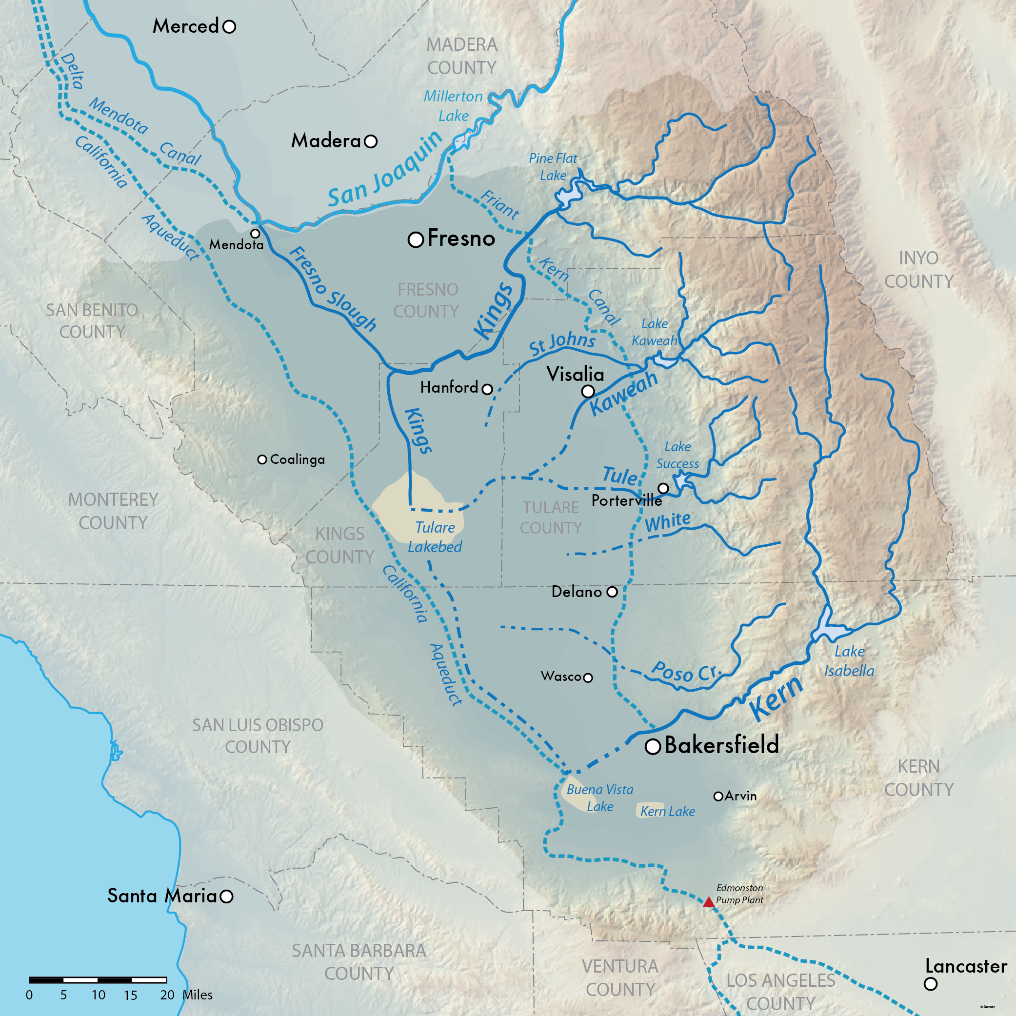
After a decade of work, the Tule River Tribe has released nine beavers into the nation’s reservation in the foothills of California’s southern Sierra Nevada mountains. The beavers are expected to make the landscape more fire and drought resistant. Beaver dams trap water in pools, making the flow of water slower so the surrounding ecosystem can reap the benefits of the moisture while making it more difficult for forest fires to start. They can also help a forest heal after a fire by rehydrating the area. 

“We’ve been through numerous droughts over the years,” Kenneth McDarmet said, who is a Tule River tribal member and former councilman. “It’s going to be wonderful to watch them do their thing.”

Around 80 percent of the Tule River Reservation’s drinking water comes from the Tule watershed. Because the area is so important for the health of the community, the tribe has been preparing the area since 2014, building man-made dams to help the new beavers adapt more quickly. 

Temperatures worldwide are expected to get hotter, increasing drought and creating conditions that make wildfires bigger and more deadly. In California, some of the worst wildfires on record have happened in the last five years partly due to drought. In 2020, three fires burned almost a million acres in the Sierra Nevada Forest, and in 2021 a wildfire burned an additional 1.5 million acres. Bringing beavers back may offer a break.

Prior to colonization, the North American beaver population was estimated to be around 200 million. But in the 1800’s, beavers were hunted for their pelts by settlers, decimating the population, while farmers and landowners viewed — and still view them — as pests. Today, the beaver population is estimated to be about 12 million. 

But in recent years there has been a growing interest in traditional ecological knowledge from tribes, and the beaver has become celebrated as an ecological engineer. 

In 2022, the California Department of Fish and Wildlife, or CDFW, secured funding for the Beaver Restoration Program, a program designed to restore the beaver population and support conservation efforts. In 2023, the CDFW recognized beavers as a keystone species, an animal that affects other animals on the landscape like bison or bees, and thus influences the ecosystem in major ways. Their absence typically has negative effects on the landscape and its interconnected ecosystems. 

Today, the CDFW program partners with tribes, non-profit organizations, land-owners, and state and federal entities to restore beaver populations and habitats in an effort to improve climate change, drought, and wildfire resilience in California. 

“We expect better habitat conditions for native critters on the land,” said Krysten Kallum, a public information officer with the CDFW. “It creates a refuge for plants and wildlife.”

More water means more plants that can attract other types of animals to the area. The CDFW expects to see better habitat development for amphibians like the western pond turtles, southern mountain yellow-legged frogs, and southwestern willow flycatchers, which will help increase biodiversity. 

McDarment, of Tule River, said that tribal pictographs show beavers living in the area, and it’s good to see them here again.  

“My hope is to have beaver throughout the reservation,” he said. 

Map showing the Tulare Lake Basin in Central California, USA. Shaded relief data from USGS. Solid blue: Perennial streams Dashed blue: Seasonal streams Dashed light blue: Man-made aqueducts Beige: Dry lake beds. By Shannon1 – PNG version of File:TulareBasinMap.jpg, CC BY-SA 4.0, https://commons.wikimedia.org/w/index.php?curid=46989267

Workers begin raising the dam at Gross Reservoir — News on Tap

Click the link to read the article on the Denver Water website (Jay Adams):

June 6, 2024

Take an animated tour of the unique construction process.

Raising the height of a dam involves many steps, literally and figuratively. 

After two years of excavation and preparation work on the canyon around Gross Dam, workers in May began placing concrete, starting the three-year process of raising the height of the dam itself.

Denver Water is raising the height of Gross Dam by 131 feet as part of the Gross Reservoir Expansion Project. Once complete, the dam will be able to store nearly three times as much water in Gross Reservoir, which will add more resiliency and flexibility to Denver Water’s water storage system.

Workers from Denver Water and contractor Kiewit Barnard stand in front of Gross Dam in May to mark the start of the dam raise process. Photo credit: Denver Water.

Raising the dam is being done by building 118 steps made of roller-compacted concrete. Each step will be 4 feet wide with a 2-foot setback. The existing dam is 340 feet tall. The completed dam will be 471 feet tall. 

Check out this animated video to see how the process works.

This animation shows how Denver Water plans to raise the height of Gross Dam in Boulder County, Colorado, as part of the Gross Reservoir Expansion Project. #grossreservoir #civilengineering #howtoraiseadam

The construction site at the bottom of Gross Dam with equipment used to place concrete and build the new steps. Photo credit: Denver Water.

It will take roughly three years to complete all the steps, with a final completion date set for 2027.

The dam raise process begins at the bottom of the dam using roller-compacted concrete to build the new steps that will go up the face of the dam. Photo credit: Denver Water.

Planning and permitting for the Gross Reservoir Expansion Project began in 2002. Take a look at this video to learn about the process and major accomplishments.

Denver Water is raising the height of Gross Dam in Boulder County, Colorado as part of the Gross Reservoir Expansion Project. This video looks at the history of the project and the work being done to raise the dam.

Hurricane Beryl’s rapid intensification and Category 5 winds are alarming: Here’s why more tropical storms are exploding in strength

Hurricane Beryl hit the island of Carriacou, Grenada, on July 1, 2024, with 150 mph sustained winds. NOAA

Brian Tang, University at Albany, State University of New York

Hurricane Beryl was the latest Atlantic storm to rapidly intensify, growing quickly from a tropical storm into the strongest June hurricane on record in the Atlantic. It hit the Grenadine Islands with 150 mph winds and a destructive storm surge on July 1, 2024, then continued to intensify into the basin’s earliest Category 5 storm on record.

The damage Beryl caused, particularly on Carriacou and Petite Martinique, was extensive, Grenada Prime Minister Dickon Mitchell told a news briefing. “In half an hour, Carriacou was flattened.”

Beryl’s strength and rapid intensification were unusual for a storm so early in the season. This year, that is especially alarming as forecasters expect an exceptionally active Atlantic hurricane season.

Rapidly intensifying storms can put coastal communities in great danger and leave lasting scars. In 2022, for example, Hurricane Ian devastated portions of Florida after it rapidly intensified. To this day, residents are still recovering from the effects. As Beryl continued across the Caribbean Sea on July 2, Jamaica and the Cayman Islands were under hurricane warnings.

Two satellite images show how the storm became more organized around the eye over a short period of time.
Two satellite images of Beryl taken on June 29, left, and June 30: As Beryl rapidly intensified, an eye formed, and deep thunderstorms wrapped around it. Cooperative Institute for Research in the Atmosphere

What causes hurricanes to rapidly intensify, and has climate change made rapid intensification more likely?

I research hurricanes, including how they form and what causes them to intensify, and am part of an initiative sponsored by the U.S. Office of Naval Research to better understand rapid intensification. I also work with scientists at the National Atmospheric and Oceanic Administration to analyze data collected by reconnaissance aircraft that fly into hurricanes. Here’s what we’re learning.

How did Hurricane Beryl intensify so quickly?

Rapid intensification occurs when a hurricane’s intensity increases by at least 35 mph over a 24-hour period. Beryl far exceeded that threshold, jumping from tropical storm strength, at 70 mph, to major hurricane strength, at 130 mph, in 24 hours.

A key ingredient for rapid intensification is warm water. The ocean temperature must be greater than 80 degrees Fahrenheit (27 Celsius) extending more than 150 feet below the surface. This reservoir of warm water provides the energy necessary to turbocharge a hurricane.

Scientists measure this reservoir of energy as ocean heat content. The ocean heat content leading up to Beryl was already extraordinarily high compared with past years. Normally, ocean heat content in the tropical Atlantic doesn’t reach such high levels until early September, which is when hurricane season typically peaks in activity.

A chart shows ocean heat content over the main development region for hurricanes in the Atlantic much higher in 2024 than any year of the past decade.
Ocean heat content of the Atlantic Ocean region where a large proportion of hurricanes form. The bold red line is 2024’s ocean heat content, and the blue line is the 2013-2023 average. Brian McNoldy/University of Miami

Beryl is a storm more typical of the heart of hurricane season than of June, and its rapid intensification and strength have likely been driven by these unusually warm waters.

In addition to the high ocean heat content, research has shown other environmental factors need to typically align for rapid intensification to occur. These include:

My research has shown that when this combination of factors is present, a hurricane can more efficiently take advantage of the energy it gathers from the ocean to power its winds, versus having to fight off drier, cooler air being injected from around the storm. The process is called ventilation.

Simultaneously, there is an increase in air being drawn inward toward the center, which quickly increases the strength of the vortex, similar to how a figure skater pulls their arms inward to gain spin. Rapid intensification is akin to a figure skater pulling in both their arms quickly and close to their body.

Has climate change affected the likelihood of rapid intensification?

As oceans warm and ocean heat content gets higher with climate change, it is reasonable to hypothesize that rapid intensification might be becoming more common. Evidence does suggest that rapid intensification of storms has become more common in the Atlantic.

Additionally, the peak intensification rates of hurricanes have increased by an average of 25% to 30% when comparing hurricane data between 1971–1990 and 2001–2020. That has resulted in more rapid intensification events like Beryl.

This increase in rapid intensification is due to those environmental factors – warm waters, low vertical wind shear and a moist atmosphere – aligning more frequently and giving hurricanes more opportunity to rapidly intensify.

A chart shows an increase in rapidly intensifying hurricanes over 36 years.
Two long-term datasets show an upward trend in the proportion of Atlantic hurricanes that rapidly intensified from 1982 to 2017. Bhatia et al. (2022)

The good news for anyone living in a region prone to hurricanes is that hurricane prediction models are getting better at forecasting rapid intensification in advance, so they can give residents and emergency managers more of a heads-up on potential threats. NOAA’s newest hurricane model, the Hurricane Analysis and Forecast System, shows promise to further improve hurricane forecasts, and artificial intelligence could provide more tools to predict rapid intensification.

This article has been updated with Cayman Islands hurricane watch upgraded to a hurricane warning.

Brian Tang, Associate Professor of Atmospheric Science, University at Albany, State University of New York

This article is republished from The Conversation under a Creative Commons license. Read the original article.

Coyote Gulch’s excellent EV adventure: Baseball!

Coyote Gulch’s Leaf charging at a -chargepoint+ facility in Oakley, Kansas July 2, 2024.

I took a few days off to drive to Kansas City, Missouri for a baseball game between the Kansas City Quitters and the St. Louis Skeletons. The Skeletons are a new team having formed from an extended circle of friends in St. Louis, just over a year ago, and they emerged from the game victorious over the home team. The Quitters fell behind early but staged a furious comeback in the late innings and came up one run short at the end. I love the diverse player rosters which included women in key positions.

“Skeleben” trying to keep the Skeletons ahead during the late innings June 29, 2024. Coyote Gulch is in the photo upper left white t-shirt.

At least for this game the league has an innovative format. The game was paused after the 4th inning for a Punk Rock concert with two local bands. The players got the chance to relax with some dancing and some time to hydrate (It is hot in Kansas City in June). I don’t often listen to Punk Rock but I have great respect for the musicians that played on Saturday. How many times is the venue a baseball diamond facing home plate? Probably not many.

4th inning Punk Rock concert during the baseball game between the Kansas City Quitters and the St. Louis Skeletons June 29, 2024 at Penn Valley Park in Kansas City, Missouri.

I don’t like to take my Leaf on these long drives. It has an old charging technology and it takes planning to find chargers with CHAdeMO connectors. This trip was necessitated by Hertz cancelling my Tesla rental the day before I was to leave — they said a hail storm had left them short of Teslas to fulfill my contract.

I charge fairly often so that I don’t have to spend too much time at each stop and so I can chew up charge at highway speeds without concern.

Charging was a breeze however as -chargepoint+ chargers were available in Limon, Burlington, Oakley, and Topeka and -chargepoint+ has CCS and CHAdeMO connectors on all of their chargers that I’ve used. There is a sort of CHAdeMO desert in Kansas but in Hays the Walmart has an Electrify America facility with one CHAdeMO connector and in Salina I’ve charged at Casey’s General Store near I-70. That charger was out of service however both ways on this trip but I was able to charge at Marshall Motor Company (a Nissan dealership) in Salina. It is very fast but only available during business hours. After Salina I charged in downtown Topeka (I unplugged an F-150 Lightning that had a full charge since there is only one -chargepoint+ charger there) then proceeded to my hotel in Kansas City.

Charging for the way home was at Wyandotte Plaza in Kansas City, Kansas on a very fast EVGO charger, then Topeka, Salina, Hays, Oakley, Burlington, and Limon.

If you are looking to buy an EV I don’t recommend the Leaf if you plan to go on long drives, charging just adds too much time. I don’t have any experience with the newer EVs with CCS connectors but they potentially charge very quickly if the KW potential at charging infrastructure is a fair indicator.

The Tesla charging network is fantastic and is integrated with their vehicle navigation system so that is my EV of choice for long trips. The navigation system takes you to the Tesla Superchargers and they are all about getting you in, charged, and out. Hopefully Hertz will get their supply in order before I need to rent the next one.