After dam release, river runs through the Lower Dolores — The Durango Herald

Dolores River Canyon near Paradox from the Coyote Gulch archives.

From The Durango Herald (Jonathan Romeo):

Overgrown banks, loads of sediment in the waterway and a depleted fishery cast a pale backdrop to an otherwise awe-inspiring float down the lower Dolores River, known for its deep canyons, lush ponderosa forests and seemingly endless succession of whitewater.

“And all of that is just a reflection of the channel starting to reflect the current hydrology,” said Colorado Parks and Wildlife aquatic biologist Jim White. “It has changed.”

[…]

Today, water out of McPhee Reservoir, considered the most expensive allotments in the Southwest, mainly supplies farms growing alfalfa, one of the most water-intensive crops used to feed cattle.

The divisive interests between farmers and recreationists have caused a debate over water rights to rage on for almost four decades.

A different riverSince the dam operates on a “fill, then spill” policy, enough water to float the lower Dolores River is only released when the dam is at capacity, and there’s no other place to store inflows.

That hadn’t happened since 2011 – until this year, when two small releases allowed boaters as well as wildlife officials to get an inside peek at what’s been happening to the long-neglected stretch of river.

And it didn’t look good.

The wildlife division’s White said a survey of the 19-mile stretch from Bradfield Bridge to the Dove Creek Pump Station found only 150 brown trout, a non-native species, and came up nearly empty-handed on native species.

“The loss of consistent spring flow to maintain habitat, coupled with altered base flow regimes, just all adds up to where we’re seeing reduced numbers of native species,” White said. “But what struck me, just the abundance of fish in general, native and non-native, is low through that part of the canyon.”

Another discernable transformation noted by many boaters was the unbridled vegetation that has started to bottleneck the river’s original channel. It was one of the most striking changes Sam Carter, board president of the Dolores River Boating Advocates, noticed on his trip this year.

“The overgrowth was intense, and dangerous,” Carter said. “There were two places that made it dangerous to move in a rapid.”

Carter said for the most part, this year’s release was a success: The large turnout of Dolores River aficionados worked together at boat launches, the weather made for hot days and warm nights, and the past year’s lack of access to the river left campgrounds, and the canyon in general, as wild as ever.

Yet a larger issues looms.

“This one spill is not the answer,” Carter said. “There has to be a change in the paradigm how that water is used. The river is getting killed. It’s a slow process, but it is happening.”

Is change possible?Mike Preston, general manager of the Dolores River Water Conservancy District, said at this point, it is “highly, highly unlikely” that any changes would occur to the management plan for the Dolores River.

Preston, a boater himself who took a trip on the Dolores River this year, said many farmers in the area made large investments setting farms up based on the water allocations.

“One boating day at 1,000 cubic feet per second is enough water to irrigate 1,000 acres for a full season,” he said. “And the farmers are paying us to maintain the facilities. And they also make payments to the federal government.”

Indeed, John Porter, a farmer turned Dolores Water Conservancy District manager who retired in 2002, said he’s clear in his bias for use of the river.

“There’s another side of it,” Porter said. “Do you just quit farming in this area and leave the water in the river? Until McPhee, it was dry river in the summertime because all the water was diverted. This project at least keeps it as a full-time river.”

Though the Dolores flowed anywhere from 800 to 1,500 cfs during the release, river levels throughout the year remain chronically low. In 2013, for instance, the river was at a trickle at just 13 cfs. The boating advocate’s president Carter said that doesn’t exactly constitute a healthy, flourishing river.

Carter said the group is “very actively” working on ways to secure annual releases out of McPhee for the benefit of recreationists and the environment.

“It’s not going to happen overnight, but we’re definitely working on it,” Carter said.

But for now, as the Dolores River slowly returns to its dispossessed flows, boaters look with a mixture of frustration and optimism toward next year.

“It was very much a bigger adventure than I think most people anticipated,” said Josh Munson, a board member of the Dolores River Boating Advocates. “Many longtime boaters noted the same things. It was faster, more wild. But the lack of water is really changing the characteristic of the river itself.

“When there isn’t a recreational release, it really isn’t much of a river.”
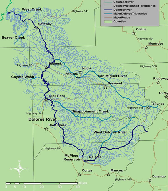
Dolores River watershed

Hundreds of boaters raft Dolores for first time in four years — The Cortez Journal

From The Cortez Journal (Jim Mimiaga):

Over the weekend, hundreds of boaters took advantage of a three-day whitewater release on the Dolores River below McPhee dam, the first in four years.

Reservoir managers said Sunday, the minimum rafting flows will continue until at least Tuesday, June 7.

The weekend whitewater release was announced last week on short notice, and within hours, the boat ramps at Bradfield Bridge and Dove Creek Pumphouse began filling up local boaters and their brightly colored rafts, kayaks, canoes and dories…

Friday morning, a parade of boats disappeared into the sunny Ponderosa Gorge, the first leg of 97-mile stretch to Slick Rock that features rapids, camp spots, remote hiking and spectacular scenery.

Bears roamed the shorelines and campsites, and were startled by the sudden presence of humans. River otters swam among boaters, and desert big horn sheep looked on from above.

A new rock fall in the river at mile-marker 17.2 can be skirted river left.

Dolores River watershed

Whitewater release announced for the Lower Dolores — The Cortez Journal

Dolores River near Bedrock

From The Cortez Journal (Jim Mimiga):

Reservoir managers have announced a 10-day spill at an approximate rate of 1,000 cubic feet per second. However the plan is to begin the release the first weekend of June instead of over Memorial Day as forecasted last week.

“There will be a spill, and by pushing it forward we’re setting up the boaters for a longer season with improved rafting flows,” said Mike Preston, manager for the Dolores Water Conservancy District.

Warmer weather beyond the current five-day forecast could accelerate the start of the spill by a few days.

McPhee will fill and provide full farmer allocations, with an estimated left-over water for rafting.

Cooler, stormy weather and significant snowpack holding in the mountains forced managers to adjust the timing of the spill until the first weekend of June.

Reservoir managers are waiting on a second peak runoff from remaining snowpack.

Preston said the decision for the delay is to avoid the possibility two small spills and their associated ramp-up and ramp-down water needs. For safety, spills are gradually increased 200 cfs at a time, then reversed at the end of the controlled spill.

Releasing rafting flows for Memorial Day weekend was not seen as ideal for boaters because managers would have to stop it to allow the reservoir to fill. Then a second spill would likely be required to avoid overfilling the reservoir as the second peak finishes coming down.

“Delaying for one release saves ramping water to extend the season,” Preston said.

The benefits of a single combined spill of rafting flows allows for longer trips and less down-river congestion of boaters.

The district worked closely with the Dolores River Boating Advocates on the early June release decision.

“There has been definite improvement in communication between the reservoir managers and the boating community,” said DRBA board member Wade Hanson. “DWCD and the Bureau of Reclamation have been on the ball with timely public notice about a release.”

Boaters should be aware of some new changes on the Lower Dolores River.

The usual private land available for a public take-out/put-in at Slickrock is closed.

However, another landowner is negotiating with the DRBA to open public access point on land just downstream of the bridge at Slick Rock near the old store.

Farther down river, the BLM’s Big Gypsum Valley river access remains open.

Boaters should be especially alert this season on the Lower Dolores because it has not been floated for many years.

A large boulder fall has been reported in Ponderosa Gorge upstream of the Dove Creek pump house at mile 17, and debris flows and log jams are a real possibility.

Also expect campsites throughout the 100-mile section to Bedrock to be overgrown.

“It’s exciting to get on the Lower Dolores after all these years,” said Hanson said. “We will be taking a lot of pictures and GPS coordinates of the campsites to inform the public.”

Dolores River watershed

Whitewater seekers might get crack at Dolores River – The Durango Herald

Dolores River near Bedrock

From The Durango Herald (Sue McMillin):

The Dolores Water Conservancy District announced on its website on Monday that recent heavy precipitation, including what’s in the forecast for this week, would likely fill McPhee Reservoir and allow for a boating release. If it happens, it would be the first since 2011.

The water district said that the precipitation combined with a cool, slow start to irrigation season has left the reservoir just 12 feet below full.

“A boating release will likely cover the Memorial Day weekend and last 5-10 days at 1,000 +/- CFS (cubic feet per second),” the website says.

The district says it will continue to keep boaters updated through the week.

The Dolores River was dammed in the late 1980s, which created McPhee Reservoir to ensure domestic water supply for Cortez and the Ute Mountain Ute Tribe, and irrigation for more than 70,000 acres of otherwise arid land.

For the latest on the reservoir levels, visit http://www.doloreswater.com/releases.htm.

Dolores water district unveils $8 million in upgrades — The Cortez Journal

La Plata Mountains from the Great Sage Plain

From the Cortez Journal (Jim Mimiaga):

Five automated, high-tech pumping stations do the heavy lifting of pulling water from canals and pushing it through pipes to farms. Another pump system at the Great Cut Dike pulls water from McPhee Reservoir into the Dove Creek Canal and onto the pumping stations.

The Dolores Water Conservancy District and the Bureau of Reclamation have teamed up for $8 million worth of upgrades for the 20-year-old pumping stations.

The four-year plan includes upgrading the electronic communication control system, or SCADA, which operates irrigation deliveries from a main control room.

So far, three out of six pumping plants have been overhauled: Fairview, Pleasant View and Ruin Canyon. Next on the list are Dove Creek, Cahone, the Great Cut Dike and the SCADA system. Final upgrades will begin after irrigation seasons and be completed over the next two years.

Water officials and engineers touted the upgrades during a public tour Thursday at the Pleasant View pump station. At Ruin Canyon, two pumps were rebuilt, and two variable-speed electric motors were replaced. The electronic drive systems were also replaced.

The same upgrade occurred at the Ruin Canyon pump station, with a total cost for both upgrades of $1.25 million.

“They are more efficient, run cooler and require less maintenance,” said DWCD engineer Lloyd Johnson. “They will last another 20 to 25 years.”

The variable speed pumps adjust to irrigation demand. As the pressure fluctuates, the electronic drive system directs the pumps to adjust and keep the pressure steady. The drive system automatically turns on other static pumps as demand requires.

“We’re here to meet demand of the farmer,” said engineer Ken Curtis. “They pay high dollar for volume when they want it, and that is why we have a big crew of electricians and mechanics to ensure it is all working.”

The Bureau of Reclamation built the dams and reservoirs and pays to update them, said Brent Rhees, BOR’s regional director for the Upper Colorado River region.

He explained that a portion of power revenues generated from Glen Canyon dam and other BOR hydro-electric plants are set aside to pay for project upgrades like the one at the Dolores Project.

“These upgrades are satisfying to see because they keep us grounded in our mission to deliver water,” Rheese said. “The BOR has transitioned to resource management of existing projects.”

DWCD chipped in $1 million toward the project.

Forum explores new potential use of Dolores River — The Cortez Journal

From The Cortez Journal (Jim Mimiaga):

A documentary screening about the Dolores River was followed by a lively forum about the issue of low flows below McPhee Dam.

“River of Sorrows” was commissioned by the Dolores River Boating Advocates to highlight the plight of the Lower Dolores River.

The new film, which is for sale on the DRBA website for $10, had several showings April 30 at the Sunflower Theatre.

A panel answered questions from a moderator and from the audience. The panel included Josh Munson of the DRBA; Mike Preston, general manager of the Dolores Water Conservancy District; Eric White of the Ute Mountain Farm and Ranch; Mike Japhet, a retired aquatic biologist with the Colorado Parks and Wildlife; and Amber Clark, of the Dolores River Dialogue.

What are the major challenges facing the Dolores River and what are the solutions for addressing those challenges?

Munson said the challenge is for people to see there are beneficial uses to Dolores River water other than just farming, such as for fishery health and boating. Changing the water rights system to allow individuals to sell or lease their water allocation so it stays in the river is one solution.

“Other uses helps to diversify the economy,” he said.

Preston said a major challenge is managing the reservoir in drought conditions. He said the goal is maximizing efficiencies in order to improve carryover in the reservoir year to year.

“High storage lifts all boats, including for recreation,” he said.

White said the film missed the compromises the Ute Mountain Ute tribe has made regarding water rights.

“Our allocation has dropped,” he said. “The tribe has fought for our water rights for a long time.”

Japhet said low flows below the dam are threatening three native fish: the flannelhead sucker, bluehead sucker, and roundtail chub.

“They have been declining precipitously,” he said.

Japhet called for more flexibility in how water reserved for fish and wildlife is managed out of McPhee. For example, 850 acre-feet diverted to the Simon Draw wetlands could be used to augment low flows on the Lower Dolores to help fish.

Clark said the big picture solution need to be collaborative and local, “or somebody from outside will find a solution for us.”

The group revealed the difficulty in finding a compromise that improves the downstream fishery and recreation boating but does not threaten the local agricultural economy.

“Use if or lose it water doctrine is a waste of water resources for farmers and conservationists,” Munson said. “The system does not allow for an individual to lease their water” for instream purposes.

Preston pointed out that in the last eight years, there has been four years where there was a release from the dam. The last one was in 2011, and this year a spill is uncertain.

“We are four for four. When we have excess water we release for boating and the fishery,” he said.
Japhet said the “elephant in the room” is if one of the three native fish species is petitioned for listing on the endangered species list.

“It would cause the U.S. Fish and Wildlife to take a very close look at what is going on with the water and fish resource,” he said. “The best solution is to be proactive and work something out locally to avoid a federal mandate telling us what to do.”

An audience member asked if the river itself has a right to water. Preston said the state instream flow program designates minimum flows for the river, including a 900 cfs below the confluence with the San Miguel. Below the dam the instream flow designation is 78 cfs.

“The river has a right to water, the fact that it was once wild should stay in people’s minds,” Munson replied. “The place itself has a beneficial use for fish, birds, otters. It’s recreation provides a way to make a living.”

Betty Ann Kohlner expressed concerns about McPhee water being used for hydraulic fracturing used for drilling natural gas.

Preston said about 4,000 acre-feet is available in McPhee for municipal and industrial purposes, including for fracking. But, he said, There has been limited use of the water for that purpose.

“If you can lease water to frack, why can’t water be leased for recreation and fish needs downstream from willing owners?” responded one man. “There is a contradiction in how we apply our understanding of how we should use water.”

Don Schwindt, of the DWCD board, pointed out that the Dolores River is part of the Colorado River compact that divides the state’s river water with several downstream states.

“Two thirds of the state’s water is required to leave by compact, and as it leaves it is available in the streams,” he said. “That two-thirds is more dominate than agricultural use.”

Dolores River watershed

Film: The River of Sorrow

I had the pleasure of viewing the new documentary “River of Sorrow” from the Dolores River Boating Associates yesterday at the eTown Hall in Boulder. The Colorado Water Trust hosted the event. River Network President Nicole Silk, CWT Executive Director Amy Beattie, and filmmaker Cody Perry introduced the film by detailing their personal experiences which led them to a life working with water.

In the film a farmer in Montezuma County detailed the necessity, from her point of view, for McPhee Reservoir. She acknowledged that she understood the motivation of those that want higher releases from the dam for recreation and the environment and the conflict it causes with the irrigators in the Montezuma Valley.

This is the main message: There are too many straws in the Dolores River, or as one person in the film, says, “Yeah, the Dolores River is very iconic, but it’s really a river no more.”

One of the highlights was the rare film footage of boatmen and enthusiasts from the heyday of boating in the years leading up to first fill. Even after first fill the boating survived until the diversion structures were built and started delivering water from the Dolores Project to the San Juan Basin.

The reservoir filled during a wet time and for a while there was a gold medal trout fishery below the dam. Then dryness hit the region (and is still around).

Now, organizations are attempting to reconcile competing views, learning that water rights are in control, and trying to find recreation and environmental water for the river.

Here’s a review from Dennis Webb writing for The Grand Junction Daily Sentinel:

A new documentary film on the Dolores River is to some degree a lament to a river lost, or at least transformed to a degree that it’s hardly recognizable to people with long memories.

“River of Sorrows: Inheriting Today’s Dolores River,” … documents the changes wrought on the river first by the construction of the dam at McPhee Reservoir near the town of Dolores in the 1980s, and then by drought.

While it’s a story about one waterway, it’s one that echoes in river canyons across the West that face challenges similar to the one on the Dolores when it comes to competing demands for scarce water supplies.

“You could say that the Dolores is the canary in the coal mine,” said filmmaker Cody Perry of Rig to Flip, a film production company based in Steamboat Springs. “You could say that the Dolores is potentially the future of every river in the Colorado River Basin in terms of if we have intentions to further develop every drop.”

The Dolores originates in the snowfields of the San Juan Mountains, heads southwest to Dolores and then north along the Colorado border to Gateway before crossing into Utah and its endpoint, the Colorado River.

Perry’s company contracted with the group Dolores River Boating Advocates to tell the river’s story, and particularly describe its life before and after McPhee Reservoir.

The reservoir project provided an important supply of water to agricultural users, as the film shows. But, except for in the wettest of years, it went far in decimating whitewater rafting on what was coming to be considered one of the nation’s best stretches of whitewater, below the reservoir. The river had been growing in renown for its rapids and pristine, slickrock-studded scenery.

For the first five years or so after the dam’s construction, the stretch below it did prove to be a prime trout fishery. But then drought hit, flows dropped below the dam to as little as 20 cubic feet per second, the water warmed and many fish died along the stretch of the river above its confluence with the San Miguel River in Montrose County.

The film quotes Montezuma County Commissioner Larry Don Suckla about the passions boaters, anglers, farmers and others feel regarding the river, and the fact that each group feels threatened.

“But in reality everybody owns that river,” Suckla said.

From the farmers’ perspective, the fear is that they will get less water if more water is released downstream for the fish, he said.

“All the water is already allocated. There is no extra water that is available to send down the river,” Suckla says.

“It’s going to be hard to get this fixed,” he adds later.

The comment succinctly sums up the challenge faced by water managers and the competing interests when it comes to the Dolores, which got its name from the Spanish “El Rio de Nuestra Señora de Dolores,” meaning “The River of Our Lady of Sorrows.”

For whitewater enthusiasts, the film’s high point also is bittersweet. The filmmakers developed contacts with river guides who dug up film footage from the old days of the Dolores when the rapids sometimes raged, including in 1983, the epic spring runoff year when Lake Powell almost overflowed.

Immediately after showing this footage, the film cuts to the lower Dolores today below the dam, barely trickling with water. An unnamed voice provides narration.

“Yeah, the Dolores River is very iconic, but it’s really a river no more. It needs to be seen and supported and it needs to be a river again,” says the voice, which Perry said is that of Andy Hutchinson, a famed Grand Canyon river guide who serves on the board of Dolores River Boating Advocates.

Perry said the archival footage is both thrilling and a reminder of what’s been lost.

“There’s generations of kids who have no idea about this river, and we don’t have that piece of whitewater anymore. It’s a cultural loss, and the generations of people who ran it — there’s a massive gap to today’s river runners who have no idea that was down there,” he said.

He said he’s shown the film to schools, groups of so-called “water buffaloes” and others. He said he was surprised that water managers in particular thought it does a good job of describing the players and issues at hand.

stopcollaborateandlistenbusinessblog

While the film is sympathetic to boating and environmental interests, he said some more extreme environmentalists wish it was edgier. But he feels the film’s job was to educate more than advocate.

“Seven of 10 people in Colorado have never heard about this river, let alone the issues that are specific to it yet also common to other rivers,” he said.

Perry said he’s concerned about the future of agriculture, too. His hope that in the case of the Dolores River, agricultural, recreational and other interests can be willing to show more flexibility in their discussions with each other, and that legal tools can be provided for permanent transfer or long-term leasing of agricultural water for instream flows.

The various interests “need to stop digging in their heels and we have to start meeting each other halfway,” he said.

Go see the film then take in the sights of Four Corners and see the country and the Dolores River for yourself.

Dolores River watershed

Forecast calls for rafting on Dolores River — The Cortez Journal

Dolores River near Bedrock

From the Cortez Journal (Jim Mimiaga):

McPhee Reservoir managers announced Friday that the forecast calls for a whitewater release below McPhee Dam.

“The forecast shows a 22-day whitewater season,” said Bureau of Reclamation engineer Vern Harrell. “But it is a 50-50 probability, so it is not guaranteed it will materialize.”

Based on this year’s impressive snowpack in the mountains, runoff forecasts show the reservoir will fill, and there will be 68,000 acre-feet available for a spill into the lower Dolores River.

Here is the plan if the snowpack holds:

On May 17, flows below the dam would be increased to 500 cubic feet per second. It would ramp up to 900 on May 18, then 1,300 cfs on May 19, and 1,500 cfs on May 20.

From May 21-25, the plan is to max out the flows at 2,000 cfs, then they will drop slightly to 1,800 cfs from May 26 to June 1 for the Memorial Day weekend.

On June 2 flows will be reduced to 1,400, cfs, drop 1,000 cfs on June 3, to 800 cfs on June 4 and 5, to 600 cfs on June 6 and 7, to 400 cfs for June 8 and 9, then 200 cfs for June 10 and 11.

Minimal rafting flows is 600-800 cfs, and for kayaks it is 300-400 cfs. Tubing could be done at 200 cfs.The boating community is excited, but cautious, said Josh Munson, vice president of the Dolores River Boating Advocates…

There has not been a whitewater release below the dam since 2011.

The surge of water into the lower canyon will benefit the natural environment, Munson said, and create an economic boon to the area as recreational boaters descend to the various launch sites.

CDPHE tags 105 miles of the Lower Dolores River as impaired

Dolores River watershed

From The Cortez Journal (Jim Mimiaga):

Colorado has listed 105 miles of the Dolores River between Slick Rock and the Utah state line as an impaired waterway because of high water temperature from chronic low flows.

The Water Quality Control Commission of the Colorado Department of Health and Environment ruled on the river’s impairment status during a hearing in December.

The section on the Lower Dolores River is “considered impaired because the temperature was greater than standards adopted to protect aquatic life,” said Meghan Trubee, media relations official with the Colorado Water Quality Control Commission. “We’re mostly concerned about the fish and macro invertebrates.”

[…]

“Because the stream is listed as impaired, the division is responsible for developing a plan to address the temperature impairment known as total maximum daily load (TMDL),” Trubee said. “The segment will remain on the 303(d) list until a TMDL is developed and approved by the EPA.”

A year’s worth of temperature data from a water-quality station at Slick Rock showed the river went above the daily maximum temperature standard 10 times – five in September 2013 and five in June 2014.
The separate readings went above daily maximum standard for March to November of 28.6 Celsius, or 83 degrees Fahrenheit.

“Warmer water has less ability to hold dissolved oxygen, which fish need,” said Jim White, a fish biologist with Colorado Parks and Wildlife. “The other reason is that higher base flows in the summer would create more habitat for growing invertebrates, the food relied on by native fish.”

The impaired section is below McPhee dam and reservoir and has not had a recreational whitewater release since 2011.

Water allocated for fish habitat, about 31,796 acre-feet, is held in McPhee reservoir and released throughout every year. In the winter, flows below the dam are 20-30 cfs. During summer, they reach 60-80 cfs if there is no whitewater release.

A series of low snowpack years have left the reservoir below full and only able to supply irrigation demands. A whitewater release occurs when there is more runoff than the reservoir can hold.

The Dolores Water Conservancy objected to the lower Dolores impairment listing, but wasn’t successful

Dolores River: Water Protection Work Group formed to protect ag and muni interests

Dolores River watershed

From the Cortez Journal (Jim Mimiaga):

The newly formed Water Protection Work Group was created in response to a proposed National Conservation Area for the lower Dolores River.

The WPWG seeks to protect municipal and agricultural water supplies in Montezuma and Dolores counties from any consequence arising from NCA legislation.

Participants include Phyllis Snyder, Larry Don Suckla, Zane Odell, Doug Stowe, Greg Black, Don Schwindt, Drew Gordanier, Bernard Karwick, Bob Bragg, Keenan Ertel and Gerald Koppenhafer.

The recently released their minimum requirements and recommendations to David Robbins, a Colorado water attorney who has reviewed the NCA proposal.

“Prior public promises that the NCA ‘is not about taking water’ are appreciated and allow us to move forward with some assurance,” the group states in a memo. “Ambiguity and conflicting provisions must be left out of the NCA draft legislation.”

Some of the recommendations include:

The group wants the preamble of the NCA to be more specific about the Dolores River’s importance as the region’s sole water supply.

A proposed advisory committee in the draft NCA legislation requires more thorough definition.

The draft NCA bill must be written to explicitly prohibit any federal express or implied water rights on the Dolores River.

The draft NCA bill must release the Dolores River, upstream from the confluence with the San Miguel River, from consideration under the Wild and Scenic River’s Act. The recommendation also stipulates that no wild and scenic river portions below the San Miguel confluence can reach upstream water rights.

The NCA shall not affect the Dolores Project or the operation of McPhee Reservoir in any way.

The draft NCA bill has language prohibiting the building of large scale water projects. The WPWG recommends that large scale water projects be defined to exclude all existing projects, diversion, structures and water rights. Also, they recommend that the proposed NCA must not impact future projects under Colorado state water law that do not exceed 50,000 acre feet of annual use.

The group also wants written into any NCA legislation that management plans will not impact or influence releases or spills from McPhee dam, the water upstream from McPhee Dam, or the Dolores Project.

In April 2015, a legislative subcommittee of the Lower Dolores Plan Working Group released a draft bill that would designated a portion of the river an NCA and another portion a wilderness area.

In exchange, the river’s suitability status for a wild and scenic river below McPhee dam would be dropped.

The proposed Dolores River National Conservation Area would stretch from below the dam at Bradfield Bridge to Bedrock, Colo., and include the river and public land on both sides.

The draft bill also proposes to designate the Dolores Canyon Wilderness Area, a 30,119-acre swath of remote canyonlands that has been managed as a BLM wilderness study area for decades.

According to the draft, the Wilderness Area boundary would be located at the edge of the river, and no portion of the Dolores River will be included in it.

However, the draft bill shows the Dolores river would be part of the NCA, including where it runs through the wilderness area.

Dolores River Canyon near Paradox

Dolores River film explores water conflicts common in West — The Durango Herald

From The Durango Herald (Jonathan Romeo):

A new documentary slated for a January release lays bare the rigid conflicts over water use along the drought-stricken Dolores River, as irrigators, rafters and others strive for some sort of balance.

About a year ago, Dolores River Boating Advocates received a grant from Patagonia to create a film about the spectrum of issues that surround the Dolores River.

River filmmakers Rig to Flip won the bid and spent more than 50 days filming this summer. Now in post-production, project director Cody Perry said the documentary – “River of Sorrows: The Dolores River Project” – will premiere in Dolores on Jan. 15.

“The Dolores River represents some of the most important issues facing communities throughout the West,” Perry said. “It’s really a case study on the dangers of a transbasin diversion.”

The Dolores River was dammed in the late 1980s, effectively forming McPhee Reservoir, and various stakeholders drafted the Dolores Project Plan, which set out to secure water supplies – in years past water flows would either run dry or dangerously low because of overuse.

Most of the water was allocated to irrigate more than 70,000 acres of otherwise arid land, allowing farmers to extend the planting season through September. However, the top priority on the list was communities outside the river’s basin reliant on the water for domestic purposes: namely, the city of Cortez and the Ute Mountain Ute Tribe.

When all was said and done, annual downstream releases of the Dolores were more than cut in half. Add that to nearly two decades of drought in the Colorado River basin, and it’s no wonder tensions have arisen over water rights.

Critics of the Dolores Project, namely boaters, say the plan leaves little room for fisheries and recreation to thrive on the river. Though those two uses are part of the plan, high levels of water are released only in years of excess, which have become increasingly rare.

“My approach to managing the district is that all of these things matter,” said Mike Preston, general manager of the Dolores Water Conservancy District. “Providing water to farms is highly critical to those families and the local economy, and providing water to the community is obviously very important.

“But we are equally obligated by law to take care of the fishery, and provide boating days,” he said. “I take those obligations as seriously as the others.”

Lee-Ann Hill, program coordinator for the Dolores River Boating Advocates, said because water managers allocate only a few days a year to large releases, it’s difficult to plan trips in advance and sustain a livelihood…

“We wanted to portray the matrix,” she said. “Every user has an idea that’s probably through the lens of their dominant use. But at the end of the day, we need to use this source together.”

And Hill, who has rafted the Dolores River in good years, can’t express enough to those who have never had the chance how important it is to reopen the lower portions of the river.

“It’s magical,” she said. “It’s been compared to other legendary rivers and canyons, like the Grand Canyon and Salmon River, and it’s true. Passing through it is a really different experience. It just resonates.”

Perry acknowledged that in making a film as an avid rafter, backed by a boating advocate group, it was important to let the people invested in the Dolores River from all sides tell the story.

“We don’t really have an agenda, or believe in that kind of thing,” he said. “If anything, it’s the people telling the story. The story exists out there will all these constituents, and we’re really guided by a single question: What do we stand to inherit here?”
Preston said when an outsider comes in and puts a spotlight on something as sensitive as the Dolores River, it can go either way: The film can needlessly stir up emotions, or be a useful tool for communication and education…

The filmmakers are now asking for donations through an IndieGoGo page for the final editing costs associated with the documentary. Perry said he plans to show the film throughout the region and, he hopes, beyond.

Cortez plans to install 3,000 smart water meters this summer

Wireless meter reading explained

From The Cortez Journal (Jessica Gonzalez):

Funding is in place for the City of Cortez to embark on a $1.2 million replacement of more than 3,000 manually read water meters with automated meters.

Mayor Karen Sheek and City Council approved loan and grant funds from the Colorado Water Conservation Board at the April 14 council meeting.

Through this project, the city intends to replace its current meters with automated meter readers, which use radios to collect data via a drive-by or a fixed-base receiver on every metered account in the city’s system.

The project is being funded through $250,000 in grants from the CWCB and the Department of Local Affairs, $350,000 from the city’s fund balance and $850,000 loan from the CWCB. Once bids are opened in mid-May, there will be a more precise picture of exactly how much the city will need to borrow via loan funding, said Phil Johnson, director of Public Works. It’s likely to be less than the $850,000 total…

The Public Works Department contends that the replacement project will bring the water meter system into the future with more streamlined billing and data management. It also says that it encourages conservation by providing users with more accurate water-consumption information…

After the bid period in mid-May, work is expected to begin early summer. The entire system is expected to be on automatic meters by October…

The Public Works Department will be providing regular updates on the project on the City of Cortez website, he noted, but stressed that it’s a necessary change in a time where water conservation is crucial.

“It’s a step into the future going to help us run our operation more effectively and it’s an efficient tool to help Cortez save water,” he said.

More infrastructure coverage here.

Montezuma County, et al., come out against a National Conservation Area — Lower Dolores River

From the Cortez Journal (Jim Mimiaga):

The Montezuma County commission and San Juan Basin Farm Bureau have publicly come out against a fledgling proposal to create a National Conservation Area on the Lower Dolores River.

Citing concerns that the designation could result in additional water being released downstream from McPhee Reservoir, the commissioners voted 3-0 to oppose any such plan…

But others involved said it is too early to take sides because the bill is still in a draft form and has not been released to the public yet.

“I think there is some misunderstanding of the intent of the NCA,” said Al Heaton, also a member of a legislative committee. “Once it’s out, there will be significant time for the public to read the draft and weigh in on it. It’s good to air it out, because there’s room for discussion, clarification and negotiation.”

The Lower Dolores Plan Working Group has been researching legislation for an NCA on the Lower Dolores River below McPhee dam since 2010. A draft is near completion and is expected to be available for review in the coming weeks.

At Monday’s commissioner meeting, Suckla said a draft he saw was “disturbing.” He was critical of the balance of 15 organizations listed in a memorandum of agreement directing the NCA proposal.

“This list is so unfair as far as equal representation for citizens of the county,” he said. “As a commission, our job is to protect property and water rights in Montezuma County, and I only see five entities here that side with that. Where’s the mining interests, the farm bureau, the private landowner interests?”

A compromise

The Lower Dolores Working group, representing various stakeholders, has been studying the environmental and commercial needs of the river below the dam for over a decade.

One conclusion reached was that improving habitat for the native roundtail chub, bluehead sucker, and flannelmouth sucker on the Lower Dolores will help prevent them from being listed by the Endangered Species Act, federal intervention local officials want to avoid.

An NCA in the valley from below McPhee dam to the confluence with the San Miguel River was proposed because the designation is seen as a flexible management tool with more local control in finding negotiated solutions to problems.

As part of the deal, the section of Dolores River that runs through the proposed NCA would be stripped of its “suitability” status for a Wild and Scenic River, a highly protectionist federal designation. If Congress ever approved Wild and Scenic for the Dolores, it would likely come with a federally reserved water right, a situation opposed by local officials.

Proponents say an NCA is a good fit because it balances conservation with commercial uses, eliminates Wild and Scenic potential for that section of river, and offers more local control than, say, a national monument.

“The group reached consensus to pursue an NCA as a way to protect values in a way that doesn’t feel threatening to some stakeholders,” Amber Kelley, Dolores River coordinator for the San Juan Citizens Alliance, said in an earlier interview. “The decision to develop an NCA as an alternative to Wild and Scenic suitability entails a compromise for everyone involved. A grass roots proposal is a far better option than having something imposed from the outside.”

But at the commission meeting some were skeptical of the NCA plan, and urged that the area continue under BLM management.

“I believe there is another way to protect fish without an NCA,” Suckla said.

‘Unintended consequences’

In a letter, the local Farm Bureau outlined its opposition, saying an NCA threatened the region’s water resources managed by the Montezuma Valley Irrigation Company and the Dolores Water Conservancy District, which operates McPhee Reservoir.

“The proposal has conflicting requirements with respect to its description of water rights and could set the stage for serious litigation,” according to the letter. “Except for new storage, the only . . . water supply . . . is from either MVIC or DWCD. This legislative path would set up a community fight between MVIC shareholders and DWCD full-service farmers.”

The letter goes on to say that the NCA proposal “does not include a water right” but because of uncertainties in federal and state water law, an NCA may have “unintended consequences driven by political or judicial actions initiated by folks with interests different than our interests.”

“We must ask ourselves, ‘are we supporting actions that may expand the ability of those interests to use the legal process to acquire water we did not intend to be available for acquisition?’”

A crux of the issue is how to improve downstream flows to benefit native fish. State and federal fish biologists have long recommended increasing McPhee’s designated fish pool for release to the Lower Dolores to 36,500 acre-feet from it’s current allocation of 31,800 acre-feet. But where the additional 4,701 acre-feet will come from has been a long-running debate.

Farm Bureau spokesperson Linda Odell said the fear is that an NCA could force the Bureau of Reclamation to acquire the additional 4,701 acre-feet from existing users.

In a statement, Marsha Porter-Norton, a facilitator with the Lower Dolores Plan Working Group, urged the public to be take time to review the proposed legislation.

“This process has always been very open and responsive to concerns that have been brought forward,” she stated. “Everyone involved knows that any successful legislation requires community support. If there are adjustments to the proposal that can be made to ensure a comfort level on the part of water users, I believe the legislative subcommittee, which contains leaders from the water community, is open to discussing those ideas.”

More Dolores River coverage here.

McPhee Reservoir update: “…inflow from the Dolores River is helping us tremendously” — Vern Harrell


From the Cortez Journal (Jim Mimiaga):

Recent rains are filling McPhee Reservoir, improving its outlook for next season.The reservoir’s elevation is 4½ feet higher than this time last year, reports Vern Harrell, a Bureau of Reclamation engineer.

“This latest storm produced 1,676 acre-feet of storage,” he said. “Irrigation outflow is pretty much done, and the inflow from the Dolores River is helping us tremendously.”

Carryover storage as of Oct. 1, 2014, is at 34,185 acre-feet, compared with 21,943 acre-feet for the same day last year, an increase of 12,242 acre-feet.

Last year, farmers suffered shortages, receiving just 25 percent of their normal water allocation because of poor snowpack and early hot weather.

This year, farmers from Dove Creek to Towaoc received 90-100 percent of their allocation, and monsoon rains reduced overall irrigation demand.

“It turned out to be a good water year,” Harrell said.

On Sept. 29, the Dolores River hit a record peak of 1,060 cubic feet per second — up from 100 cfs the day before — because of a massive rainfall event in the San Juan Mountains over the weekend. The previous record on that day was 626 cfs in 1927. On Oct. 1, the river at Dolores was flowing at 456 cfs, a boatable level.

Also this fall, significant upgrades to McPhee’s irrigation infrastructure will begin. The Bureau and the Dolores Water Conservancy District secured $4.5 million in funding for the improvements.

Automated pumping stations at Fairview, Pleasant View, Ruin Canyon, Cahone, and Dove Creek are all slated for upgrades, said DWCD engineer Ken Curtis.

The majority of the funding ($4 million) for the upgrades comes from revenues generated at the Glen Canyon hydro-electric power plant. DWCD pitched in $465,000.

“The Colorado Basin Power funds were used to pay for new reservoir projects, but there are no more of those, so now it distributes the money for upgrades and maintenance of existing facilities,” Curtis said.

The Fairview Pumping plant, which feeds off the Dove Creek canal, will receive the first overhaul at a cost of $1.6 million.

“The $500,000 needed for installation came in and construction is slated to begin in November,” Harrell said.

Now that the farming season is over, three variable-speed pumps and their 500-horsepower motors will be replaced, along with electronics and transformers.

The Fairview station delivers irrigation water through underground pipelines to 8,000 acres of farmland southwest of Yellow Jacket…

A wet fall and some carryover storage is a good sign for boaters as well. Officials say the reservoir needs an above-average winter snowpack to fill.

More Dolores River watershed coverage here.

Lower Dolores study details native fish needs — The Dolores Star

From The Dolores Star (Jim Mimiaga):

A conceptual plan for aiding native fish on the Lower Dolores River was approved by the Dolores Water Conservancy District in June. The District has been negotiating with Colorado Parks and Wildlife, the BLM, Forest Service, and conservation groups on ways to improve native fish habitat below McPhee Dam. The result is the Lower Dolores River Implementation, Monitoring, and Evaluation Plan, focusing on three native fish: the flannelmouth sucker, bluehead sucker, and roundtail chub.

“The plan provides a more coordinated approach for improving native fish habitat, with a focus on additional monitoring,” said Amber Clark, with the San Juan Citizen’s Alliance.

After McPhee Dam was built, small spills, as well as non-spill years from 2001-2004, began reducing the quality and amount of habitat required to meet the needs of native fish. Spring releases from the dam are later in the season, which has reduced the chance for spawning and survival of native fish.

“Protecting the native fish species locally is important because the healthier they are, the less likely they will be seen by the (U.S. Fish and Wildlife) agency as requiring protective status under the Endangered Species Act,” said Ken Curtis, an engineer with the Dolores Water Conservancy District. “Working to help these species keeps control of our river at a local level.”

The implementation plan presents known and preferred habitat conditions and lifecycles of native fish within six separate stretches of the river below McPhee dam, four of which are a focus of conservation: Dove Creek Pump Station to Pyramid (Reach 3), Pyramid to Big Gypsum Valley (Reach 4), Slickrock Canyon (Reach 5), and Bedrock to San Miguel confluence (Reach 6) Reach 3 (nine miles)

Roundtail Chub are most abundant in Reach 3 and have a relatively stable population there. Mature roundtail are smaller than in other Western Slope rivers, indicating they are adapting to low flows. Fish counts at the Dove Creek area counted 140 roundtail chub, the highest in 13 years.

Bluehead and flannelmouth suckers are present, but in low abundance. In 2013, eight bluehead and one flannelmouth were counted. Habitat is good for bluehead, a more cold tolerant fish.

Reach 4 (38 miles)

Disappointment enters the Dolores in this stretch, flushing sediment into the main channel.

All three native species are found in this stretch as well as problematic non-natives including the black bullhead and smallmouth bass, a voracious predator.

Studies show that populations shift toward non-native species during prolonged low-flow periods. In 2004, native species made up less than 50 percent of the fish caught. After a prolonged spill in 2005, 84 percent of the fish sampled were flannelmouth sucker or roundtail chubs. Because of silt buildup from Disappointment Creek, improving flows here would especially help native fish beat out non-natives.

In August 2013, flooding showed that Reach 4 below Disappointment caused unnatural silting, causing a significant fish kill.

A lack of water limits critical dilution effects, and there is an unnatural buildup of silt because of infrequent flushing flows. “During a flash flood event on Disappointment, the surge of debris-filled water flows into the Dolores River, but there is no water to help dilute the surge of silt-laden water,” said Jim White, a CPW fish biologist.

Monitoring native species at Big Gypsum will remain a priority as it appears that the population may be sensitive to low flow.

Flows are a big factor. In 2005, when there was a managed spill, biologists found 150 flannelmouth per hectare at the Big Gypsum site. While in 2004 when there was no spill, flannelmouth were counted at five fish per hectare.

In April 2013, a PIT-tag array was installed across the river just above the Disappointment Creek confluence. Fish are implanted with grain-size microchips and can be detected when they move. Only a few fish have been tagged in the lower Dolores, but more implants are planned. Data shows native fish move up and down the river. The cost of the PIT-tag array is about $75,000.

Slickrock Canyon (32 miles)

All three native fish species are found,but in low abundance. This canyon is difficult to survey, and can usually be floated if there is a spill from McPhee reservoir. The last survey was in 2007, but more are needed to determine if the stretch has rearing habitats for native fish. A relatively large number of small native fish was found near the mouth of Coyote Wash, suggesting tributaries play an important role for young fish.

Bedrock to the San Miguel River confluence (12 miles)

There are a lot of unknowns. It is highly affected by natural salt loading through the Paradox Valley. The salinity is a barrier for fish between the Dolores River below the San Miguel and Slickrock Canyon. A salinity injection well is operated by the Bureau of Reclamation here to mitigate the problem. Researchers want to ascertain the levels of salinity. A second PIT-tag array is considered near Bedrock to help figure out how fish move .

Spill management

Mimicking a natural hydrograph for native fish is one goal of the implementation plan.

McPhee stores most of the Dolores River spring runoff, and exports much of the storage to the Montezuma Valley of the San Juan River Basin. The result is a lack of spring flushing flows in the Lower Dolores to move sediment and create natural habitat.

When inflow into the reservoir exceeds capacity, the spill benefits boaters and the downstream fishery. However, a prolonged drought has limited spill years. The reservoir holds a fishery pool of 29,824 acre-feet allocated downstream throughout the year by CPW. Spill water doesn’t count against the fishery pool, but it is subject to shortages in dry years.

The report suggests ways to optimize the fish pool and spills for the benefit of native fish.

Thermal regime management sends water downstream earlier, in March and April rather than in May, to keep water cooler and delay the fish spawn until after the whitewater season.

Biologists have documented that when spill water is released in May, the low flows on the lower Dolores have heated up, cueing fish to spawn early.

“The fry and eggs are washed away in the whitewater, a hit on survival,” White said.

A model indicates that flow volumes of 125-200 cfs on May 1 may be necessary to keep water below 15C at the Dove Creek Pumps. More water downstream may keep water cool enough to delay spawning. A gauge at James Ranch will monitor conditions.

Flushing flows range from 400-800 cfs are important to prepare spawning areas and improve oxygenated flow around eggs.

Habitat flows ranging from 2,000 cfs to 3,400 cfs are necessary for resetting channel geometry, scouring pools, creating channels for fish nurseries. The Bureau of Reclamation urges increasing the fish pool to 36,500 acre-feet a year. A fund of $400,000 is earmarked for buying additional water, but none has been acquired using these funds.

“There has always been a desire for more water for the downstream fishery,” says Curtis, of DWCD. “Before there is a blanket grab for additional water, there needs to be a specific focus on how it will help, and those questions are being pursued.”

The goal of the Implementation Plan is to maintain, protect, and enhance the native fish populations in the Dolores River.

The area is susceptible to being overrun by small mouth bass and affords opportunity for their suppression by removing caught fish.

Managed spills scour the river bottom, and move sediment in ways that benefit native fish and their young.

Blueheads are rarely detected in this stretch.

Biologists see the problem as two-fold:

The Snaggletooth Rapid is in this stretch, making fish sampling a challenge, but regular fish monitoring is encouraged in the report.

More Dolores River watershed coverage here and here.

2014 McPhee Reservoir irrigation water allocation set

mcpheereservoiroverlook

From the Cortez Journal (Jim Mimiaga):

The Dolores Water Conservancy District, which operates McPhee Reservoir, forecasts full-service users will receive at least 15 inches per allocated acre of the 22 inches of a full contractual amount.

“It is an improvement from our last prediction of 11 inches,” said DWCD general manager Mike Preston. “But we will need additional snowpack in the next 6-10 weeks to fill the reservoir and deliver a full supply.”

Water officials emphasize that the 15 inches is the minimum amount expected to be delivered based on current snowpack levels measured at five different locations in the river basin.

According to a March 7 letter sent to irrigators, “If conditions completely dry out, the worst case works out to 70 percent or 15 inches per allocated acre.”

Late summer monsoon rains that recharged the soil is a major factor for the improved outlook.

Instead of soaking into the ground as it did in Spring 2013 due to a extremely dry 2012, snowmelt this year will reach the reservoir more.

“The improved soil moisture will prevent us from totally cratering like last year,” said Ken Curtis, a DWCD engineer.

Last year, full-service irrigators received just 25 percent of their total allocation, or about 6 inches of water per acre. Instead of three cuttings of alfalfa, most farmers harvested just one.

The latest water news is critical for farmers, who begin ordering fertilizer and seed now for the upcoming growing season. Calculations of how much to plow also depend on estimated water supplies.

“If we get a weather build up, it will just improve from the 15 inches,” Preston said…

If the high country received 4-6 inches of snow each week through April, managers predict the reservoir would reach its full irrigation supply.

On the down side, lower elevation snow is lower than normal. Also, because there is no carryover storage from last year’s dry conditions, McPhee reservoir will end very low and lack carry over storage for a third straight year.

More McPhee Reservoir coverage here.

Dolores River: Instream flow right below confluence with the San Miguel River?

Dolores River Canyon near Paradox

From the Cortez Journal (Jim Mimiaga) via The Durango Herald:

A spirited debate before the Colorado Water Conservation Board in Denver in January featured local officials expressing their opinions about a plan to increase flows on the lower Dolores River.

A live Internet broadcast of the hearing presented views for and against appropriating new minimum in-stream flows on a 34-mile section of the river below the confluence of the San Miguel River.

Representatives from the Dolores Water Conservancy District, in Cortez, and the Southwestern Water Conservation District, in Durango, attended the meeting and urged the state board to delay the matter. Local officials say new in-stream flows could threaten agricultural users who depend on McPhee Reservoir, and they want more time for negotiations with local federal agencies about newly implemented river regulations.

But they were rebuffed by the state board and state officials who argued the in-stream flows were a good way to protect struggling native fish and avoid intervention by the federal government moving to list them under the Endangered Species Act…

The proposed in-stream flow on the Dolores is for 900 cfs to flow for 61 days in the summer to aid the flannelmouth sucker, bluehead sucker and roundtail chub below the San Miguel confluence.

Eleven organizations commented on the proposed in-stream flow, some for and some against.

Mike Preston, general manager for the Dolores district, urged the state board to delay its intent to appropriate the new Dolores in-stream flow.

“These ISFs are intertwined with recent federal actions that add up to create considerable uncertainty and risk for the Dolores Project,” he said. “We ask for the delay to straighten out these issues with federal land agencies.”

The in-stream flow proposal comes on top of recent federal action on the Dolores that elevates two additional native fish, the bluehead and flannelmouth suckers, to a category called Outstanding Remarkable Values.

The values are used to categorize special aspects of rivers like the Dolores that are designated “suitable” for National Wild and Scenic River status.

Creating that official high level of protection would require an act of Congress. But reservoir managers oppose even a hint of Wild and Scenic because if ever designated, those rivers come with a federally reserved water right that could force water from McPhee to be released downstream for the benefit of native fish.

State water board director John McClow said that the in-stream flow was a good solution and questioned why it had so much resistance.

“I’m having a difficult time connecting the dots here,” he said. “We have argued to federal agencies that in-stream flows are a better option than suitability. If we declare intent to appropriate, it lets the federal agencies know that we are serious and are going to do this and provide the protection for these fish.”

After the testimony, the state water board voted unanimously to declare its intent for appropriating the proposed in-stream flows on the Lower Dolores River.

However, to give time for stakeholders to negotiate with the Bureau of Land Management about the possibility of dropping Wild and Scenic suitability, the hearing about the matter was delayed until January 2015.

Here’s a guest column about the proposed instream right and the Dolores Project, written by Mike Preston that’s running in the Cortez Journal:

There is a lot going on these days that could affect the Dolores Project and many recent events have received newspaper coverage. This column is intended to put these events into a broader context that will help those who are interested understand what is going on as this story continues to unfold.

Let’s start with the biggest long term risk to Dolores Project water supplies: A listing of any of the three sensitive native fish species on the Dolores River as Threatened and Endangered. This would put the US Fish and Wildlife Service in charge of the Dolores River resulting in a loss of control by everyone else. What is being done? Local partners including water managers, fishery managers, conservation groups, boaters and county commissioners are working together to put together a science based Native Fish Implementation Plan to evaluate opportunities to address the needs of native fish without putting water supplies as risk.

The next level of risk is the Wild and Scenic Rivers Act as a result of additions to the recently released BLM and Forest Service resource management plans which list the two sensitive native fish as Outstandingly Remarkable Values which Implementation Plan monitoring show to be uncommon and rare above the confluence with the San Miguel River. The federal plans also added flow standards that are unachievable below McPhee Reservoir. What is being done? DWCD and Southwestern Water Conservation District (SWWCD) are actively protesting and appealing these plans with the support of the State of Colorado, Colorado Water Congress, local counties and west slope water entities.

There is also a large instream flow proposed on the Dolores River below the San Miguel confluence. Representatives of DWCD and SWWCD recently appeared before the Colorado Water Conservation Board (CWCB) and asked that the instream flow proceeding be delayed until risks associated with the federal plans are addressed. The CWCB granted a delay until January of 2015 and pledged State of Colorado support in resolving the federal issues described above. The one year delay also gives local water boards the opportunity to negotiate protections to insure that the instream flow will pose no risks to water stored in McPhee and other water rights within the basin.

Given the need to manage these multiple risks, what can be done to create stability and certainty going into the future? There is a Legislative Subcommittee made up of County Commissioners, Water Managers, and Conservation Groups, grazers and OHV users that is crafting legislation that will eliminate the Wild and Scenic River designation from McPhee Dam to Bedrock, protect water rights and Dolores Project allocations, recognize the Native Fish Implementation Plan as the means of taking care of the fish, while protecting water rights, mineral rights, private property rights and access.

Are we going to be able to succeed in all of these activities designed to protect community water supplies? These efforts are grounded in community level cooperation by representatives of the full range of Dolores Project purposes: irrigation, community water providers, boating, the fishery and the health of the downstream environment. If we all stick together, we will find a way to do what’s right by our community. As this story unfolds we will make every effort to keep you informed.

More Dolores River watershed coverage here and here.

Wild and scenic designation for the Dolores River?

Dolores River near Bedrock

From the Cortez Journal (Jim Mimiaga):

New management plans by the BLM and Forest Service upgrade the status of two native fish, and list new sections of the river as “preliminarily suitable” for a Wild and Scenic designation.

Roy Smith, a BLM water specialist, explained that the suitability status for the Lower Dolores from the dam to Bedrock has been in place since a 1976, and the special status was reaffirmed in a recently released public lands management plan.

“It qualifies because below the dam, the lower Dolores is a free-flowing stream that has outstandingly remarkable values (ORVs),” he said. “A common misconception is that suitability means we can wave a wand and make it Wild and Scenic, but that is not true. That takes congressional action.”

The 1976 suitability study noted that the Dolores is compatible with a Wild and Scenic designation, and “McPhee dam will enhance and complement such designation.”

ORVs are obscure and sometimes controversial assessments that identify river-related natural values. They are an indication that a river could qualify as a Wild and Scenic River in the future. In the meantime, their natural values are protected in management plans.

In their recent management plan, the BLM and Forest Service upped the ante, adding the bluehead and flannelmouth suckers to ORV standard list, which already includes the bonytail chub.

The Colorado Water Conservation board also believes native fish on the river deserve additional help. They propose to issue a new in-stream flow requirement for a 34-mile section of the river from the confluence with the San Miguel River to the Gateway community.

Ted Kowalski, a CWCB water resource specialist, explained that the new instream flow is proposed to improve habitat conditions for native fish.

“In-stream flows are designed to protect the natural hydrographs on the river, and we feel they are better than top-down river management from the federal side,” Kowalski said. “The proposed instream flows on that section of the Dolores are timed to accommodate spawning needs for native fish.”

Required peak flows reach 900 cfs during spring runoff, and then taper off. Most of the water would be provided by the San Miguel River, an upstream tributary…

The Dolores Water Conservation Board and the Southwestern Water Conservation board objected to the changes, fearing the move could force more water to be released downstream. They have filed appeals and protests to stop them.

Even the preliminary Wild and Scenic status on the Dolores is strongly opposed by McPhee Reservoir operators because if officially designated, Wild and Scenic rivers come with a federally reserved water right, which would also force more water to be released from the dam.

Jeff Kane, an attorney representing SWCD, said adding two native fish as ORVs was unexpected and unfair to a local collaborative process working to identify and protect native fish needs…

Accusations that federal agencies and the CWCB hijacked a 10-year-long, grass-roots effort to protect the Dolores were expressed at the meeting, which was attended by 80 local and regional officials…

A diverse stakeholder group, the Dolores River Working Group, is proposing to make the Lower Dolores River into a National Conservation Area through future legislation. As part of the deal, suitability status for Wild and Scenic on the Lower Dolores River would be dropped.

“It is still worthwhile to get our proposal out there,” said Amber Kelley, Dolores River coordinator for the San Juan Citizen’s Alliance. “We should continue to move forward in our collaborative effort despite the concerns about the BLM changes.”

More Dolores River Watershed coverage here and here.

Increased flows in the Dolores River this summer enable Kokanee spawning

From the Cortez Journal (Jim Mimiaga):

Last year, there was no run because the lake was so low, explained Jim White, a aquatic biologist with Colorado Parks and Wildlife.

In low water years, the river carves a wide channel in the lake bed that is too shallow for the kokanee salmon to make their way to spawning grounds, 5 miles up river at a specially designed fish hatchery.

But deeper water triggered a run this year attracting bald eagles to the valley and a line of people at the traditional November fish giveaway in Dolores…

The kokanee spawning zone on the Dolores River is a system of ponds that drain into a concrete-formed “raceway”, controlled by gates, sieves, and fish cages. The females lay their eggs in the fine gravel, and then go off and die, becoming a meal for eagles, bears, and otters.

Some eggs are harvested by biologists and raised in the Durango fish hatchery to be distributed to other hatcheries and lakes, including back to the Dolores.

From the hatchery, they float down river and into McPhee Reservoir, with most becoming a meal for predator fish. Those that survive, about 5 percent, spend 3 to 4 years maturing and then make their way to where they were born to lay eggs.

More Dolores River Watershed coverage here and here.

Colorado Water 2012: A look at the basins of Southwestern Colorado

sanjuan.jpg

Here’s the latest installment of the Valley Courier’s Colorado Water 2012 series, written by Bruce Whitehead. Here’s an excerpt:

Southwestern Colorado’s rivers are unique in that many of the rivers and tributaries flow from north to south and are administered as independent river systems.

This is due to the fact that many, such as the Navajo, Blanco, Piedra, Pine, Florida, Animas, La Plata, and Mancos Rivers, are tributary to the San Juan River in New Mexico or just upstream of the state line. The Dolores River flows from north to south, but makes a “U-turn” near Cortez and heads back to the northwest and joins the Colorado River in Utah. The San Miguel River originates just above Telluride, and flows to the west where it joins the Dolores River just above the Colorado-Utah state line.

The southwest basin has many areas that are under strict water rights administration on a regular basis, but there is still water available for appropriation and development pursuant to Colorado’s Constitution and the Colorado River Compact. The region is also known for its beautiful scenery and recreation opportunities, which is the basis for the establishment of the Weminuche Wilderness area as well as nearly 150 reaches of streams with in-stream flow water rights. Over 50 natural lake levels are also protected by the state’s In-Stream Flow and Natural Lake Level Program.

Water leaders have been active for many years in the basin and recognized early on that in order to meet agricultural and municipal demands storage would need to be developed. The Southwestern Water Conservation District was formed in 1941, and has been responsible for the planning, development, and water rights acquisition for many of the federal projects in the region. Reservoirs such as McPhee (Dolores Project), Jackson Gulch (Mancos Project), Ridges Basin a.k.a Lake Nighthorse (Animas-La Plata Project), Lemon (Florida Project), and Vallecito (Pine River Project) provide for a supplemental supply of irrigation and municipal water in all but the driest of years. The delivery of these supplemental supplies assists with keeping flows in many critical reaches of river that historically had little or no flow late in the season due to limited supplies and water rights administration.

Southwest Colorado is also home to two Sovereign Nations and Indian Reservations that were established by treaty in 1868. Under federal law the Ute Mountain Ute Tribe and Southern Ute Indian Tribe were entitled to federal reserved water rights, which had the potential to create conflicts with Colorado water law and non-Indian water users in the basin. After nearly a decade of negotiations, a consent decree was entered with the water court that settled the tribal claims. The Tribal Settlement included some early dates of appropriation for the tribes, and a water supply from some of the federal storage projects including the Dolores, Animas-La Plata, Florida, and Pine River Projects. This landmark settlement is evidence that both tribal and non-Indian interests can be provided for with water storage and cooperative water management.

More Colorado Water 2012 coverage here.

Mancos and Dolores projects update — July end of month status

mcpheereservoiroverlook.jpg

jacksongulchreservoir.jpg

From Reclamation via the Cortez Journal:

Jackson Gulch reservoir live content stood at 3,914 acrefeet with a 9,948 acre-feet maximum capacity and a 7,322 acre-feet average (1981-2010) end-of-month content. At Jackson Gulch, a daily maximum/minimum of 52/31 cubic-feet-per second was released into the Mancos River, and 69 acre-feet were released for municipal purposes.

McPhee Reservoir live content stood at 260,582 acre-feet, with a 381,051 acre-feet maximum capacity and a 315,968average (1981-2010) end-of-month content. At McPhee, 4,301 acre-feet were released into the Dolores River, and 42,398 acre-feet were released for trans-basin purposes. At McPhee, a daily maximum/minimum of 71/69 cubic-feet-per-second was released into the Dolores River.

More McPhee Reservoir coverage here. More Jackson Gulch Reservoir coverage here.

McPhee and Jackson Gulch reservoirs status

jacksongulchreservoir.jpg

mcpheereservoiroverlook.jpg

From the U.S. Bureau of Reclamation via the Cortez Journal:

Jackson Gulch reservoir live content stood at 6,020 acre-feet with a 9,948 acre-feet maximum capacity and a 9,014 acre-feet average (1981-2010) end-of-month content. At Jackson Gulch, a daily maximum/minimum of 76/51 cubic-feet-per second was released into the Mancos River, and 88 acre-feet were released for municipal purposes.

McPhee Reservoir live content stood at 299,646 acre-feet, with a 381,051 acre-feet maximum capacity and a 343,394 average (1981-2010) end-of-month content. At McPhee, 4,120 acre-feet were released into the Dolores River, and 45,079 acre-feet were released for trans-basin purposes. At McPhee, a daily maximum/minimum of 70/57 cubic-feet-per-second was released into the Dolores River.

Questions can be directed to the Southern Water Management Group, Resource Management Division of the Western Colorado Area Office, Durango.

More Dolores River Watershed coverage here. More Mancos River Watershed coverage here.

Plateau Creek: The Dolores Water Conservancy District is moving on a pumpback hydroelectric project

pumpedstoragehydroelectricschematic.jpg

From the Cortez Journal (Kimberly Benedict):

The paperwork filed by the local water district is a competing proposal, a response to a similar application filed by Bellevue, Wash., engineering firm INCA Engineers. DWCD’s permit application, filed on May 10, seeks “municipal preference” for feasibility studies over the out-of-state company, which filed application paperwork with FERC on Nov. 30, 2011.

DWCD hopes its historic water rights and involvement in local water issues will win the day when permits are awarded, according to district manager Mike Preston. “DWCD holds the water rights on McPhee and certainly Plateau Creek is a tributary to McPhee Reservoir,” Preston said. “We want to maintain local control over this issue. We believe we have municipal preference because we are what is call a municipal provider, and we think we are very likely to be granted the permit.”

The local water conservancy district already operates two hydropower plants owned by the Bureau of Reclamation, Preston said.

More hydroelectric coverage here and here.

Cortez: Colorado Water 2012 events include a tour of the water treatment plant

mcpheeconstruction.jpg

From the City of Cortez:

Through a statewide program called Colorado Water 2012, the Cortez Public Library, in partnership with the Colorado Foundation for Water Education, The Colorado State Library, the Dolores Water Conservancy District and the Cortez Water Plant are offering this educational opportunity to learn about state and local water. At 10:00 AM on June 28th, there will be a presentation by Mike Preston, of the Dolores Water

Conservancy District and Don Magnuson of Montezuma Valley Irrigation at the overlook at the end of the McPhee campground. Last, on the same day at 1:00 PM, there will be a tour of the Cortez Water Plant, hosted by Bruce Smart. Maps and directions are available at the Library.

More Colorado Water 2012 coverage here.

McPhee Reservoir operations update:

mcpheereservoiroverlook.jpg

From the Cortez Journal (Reid Wright):

“Everybody can rest assured that we’re going to meet all our allocations this year,” said Mike Preston, manager of the Dolores Water Conservancy District. Due to a good amount of water being stored from last year, Preston is confident there will be enough water for irrigation, drinking and industrial use this year.

Now the focus is shifting to the coming winter and the 2013 water year. Preston said a below average winter this year could lead to shortages next year. An average winter this year would barely meet allocations, while an above average winter would be required for a whitewater boating spill on the lower Dolores River…

As of Thursday, the reservoir elevation stood at nearly 6,915 feet, compared to a full elevation of 6,924 feet. This translates to 190,187 acre feet of active capacity water compared to a maximum active capacity of 229,182 acre feet…

Up-to-date information on reservoir levels, river flows and canal flows is available on DWCD’s website: http://www.doloreswater.com/

More Dolores River watershed coverage here.

The Bureau of Reclamation has released end of year operations reports for McPhee and Jackson Gulch reservoirs

jacksongulchreservoir.jpg

From the Cortez Journal:

Jackson Gulch reservoir live content stood at 3,703 acre-feet with a 9,977 acre-feet maximum capacity and a 4,492 acre-feet average (1980-2010) end-of-month content. At Jackson Gulch, a daily maximum/minimum of 11/0 cubic-feet-per second was released into the Mancos River, and 15 acre-feet were released for municipal purposes.

McPhee Reservoir live content stood at 289,298 acre-feet, with a 381,051 acre-feet maximum capacity and a 270,692 average (1986-2010) end-of-month content. At McPhee, 1,835 acre-feet were released into the Dolores River, and 2,958 acre-feet were released for transbasin purposes. At McPhee, a daily maximum/minimum of 31/30 cubic-feet-per-second was released into the Dolores River.

More Dolores River watershed coverage here and here. More Mancos River watershed coverage here and here.

Dolores: McPhee Reservoir and Dolores Project operations meeting March 21

dolorescolorado.jpg

From the U.S. Bureau of Reclamation via the Cortez Journal:

The Bureau of Reclamation will host a McPhee Reservoir and Dolores Project operation meeting on March 21 at the Dolores Community Center at 7 p.m. Topics of discussion will focus on anticipated water releases to the lower Dolores River and an overview of the Dolores Project.

More Dolores River watershed coverage here and here.

The Dolores Water Conservancy district reaches the half-century mark November 20

mcpheereservoiroverlook.jpg

Here’s a report from Shannon Livick writing for the Cortez Journal. Click through for the photos of construction of the tunnel that brings water from the Dolores River watershed into Montezuma and Dolores counties in the San Juan basin. Here’s an excerpt:

The Dolores Water Conservancy District will host a 50th anniversary of the formation of the district and the 25th anniversary of water deliveries to farms and towns from McPhee Reservoir at the Dolores Community Center with a barbecue dinner at noon, followed by a brief recognition ceremony.

The star of the show will be McPhee Reservoir, a project that some say was more than 100 years in the making. “They have been talking about the McPhee dam site since the 1900s,” said Mike Preston, general manager of the Dolores Water Conservancy District. It has been said that the McPhee Reservoir site was seen as so ideal for a reservoir that President Teddy Roosevelt chose the site for the dam in 1906 during a hunting trip here.

“The Dolores Water Conservancy District was formed to try to get the dam built,” Preston said. The project was authorized in 1968 and the project began in 1977, after voters in Montezuma and Dolores counties within the Dolores Water Conservancy District approved a repayment contract by a unheard of 95 percent favorable vote. The McPhee Dam project cost an estimated $403 million…

The project doubled the amount of irrigated acreage in the area and gives the towns a 100-year supply of water. “This water project is something most communities would die for,” Preston said.

Since the water started to be delivered 25 years ago, the number of irrigated acres in Montezuma and Dolores counties has gone up from 35,000 irrigated acres to 70,000, some of those as far away as south of Towaoc…

The $403 million project also saw the construction of the $11.6 million Dolores tunnel that was dug underneath the landscape for more than one mile. It also saw the construction of pumping plants, numerous canals and two major recreation areas named McPhee and House Creek. It also saw the flooding of the old lumber town, McPhee, and countless archaeology sites, bringing in archaeologists from around the world who excavated the areas. Those artifacts are housed in the Anasazi Heritage Center, also built as part of this project.

More coverage from Reid Wright writing for the Cortez Journal. From the article:

According to information from the Dolores Water Conservancy District, an average of 351,000 acre feet of water flows into the McPhee Reservoir annually. Not including spring spillover, an average of 31,798 acre feet of water is released down the Lower Dolores River.

With a storage capacity of 381,000 acre feet of water, the project essentially doubled the amount of irrigated land in the area and extended the irrigation season for most farmers by nearly three months to mid October — allowing farmers to produce substantially more.

With current crop values, Mike Preston, DWCD general manager, estimates Dolores Project lands will generate $20 million in income for the area this year.

More coverage from Kimberly Benedict writing for the Cortez Journal. From the article:

Beyond the obvious recreation benefits of the reservoir, the Dolores Project also provided recreation opportunities through the creation of Joe Rowell Park in Dolores and enhanced flows on the Lower Dolores River, below the McPhee dam.

“The other thing that McPhee provided, is a means of managing the flows below the reservoir,” said Dolores Water Conservation District General Manager Mike Preston. “Usually we were in drought early and the flows would trail off. But now, those flows are managed to provide rafting flows in and around Memorial Day and so on. It gave us the ability to manage recreation opportunities in regards to recreational boating.”

The flows from the reservoir into the Lower Dolores also provide additional fishing opportunities, particularly for those interested in fly fishing.

Additionally, the presence of the reservoir has benefited wildlife. Three native fish species call the Lower Dolores home, including the flannelmouth sucker, the bluehead sucker and the roundtail chub. All three benefit from the managed flows from the reservoir, according to a report from the Lower Dolores Working Group. And according to the bureau of reclamation’s website, land acquired and managed for wildlife conservation has provided habitat for a variety of wildlife species.

More coverage from Kimberly Benedict writing for the Cortez Journal. From the article:

“The Anasazi Heritage Center was built by the (U.S.) Bureau of Reclamation as a repository for the artifacts gathered during the DAP,” said center Manager Marietta Eaton. “The Heritage Center is here because of the DAP, and that in and of itself is full of ramifications for the area.”

The Heritage Center’s creation was a unique aspect of the Dolores Archaeological Program. Most archaeological programs see collected artifacts shipped to larger repositories, often far from the actual sites. The creation of a local repository allowed the local community to retain a sense of ownership of their history.

“The fact that the Bureau of Reclamation saw the importance of a local repository is significant,” said Tracy Murphy, assistant curator at the center. “With the presence of the center, the artifacts and research are here for the people of this area.”

More coverage from Dale Shrull writing for the Cortez Journal. From the article:

Finding a good water storage solution for Montezuma County was discussed as far back as the 1880s. Today, looking at the massive McPhee Reservoir, it’s impossible to comprehend a lack of water. But [John Porter] remembers. The 78-year-old Lewis native spent 23 years as the Dolores Water Conservancy general manager, retiring in 2002. “Everyone was looking for more water but there was never enough,” he says. “Every time there was a drought, all people would talk about was we need a dependable supply of water…

Even though a dam on the Dolores was thought to be the solution, Porter wasn’t surprised it took so long to complete. “Anything you do with water, it takes time. There’s regular time and there’s water time. Water time goes very slow,” he says…

As early as 1884, plans were made and projects developed to take water from the Dolores, Porter explains. A tunnel was bored and canals were used to get water to the south, while the Great Cut Dike and canals were developed to flow water to the west. And they sucked the river nearly dry. “Back then, the Dolores River was basically a dry river during the summer,” Porter says. To store water in the early days, three small reservoirs were dug: Groundhog, Totten and Narraguinnep…

Remnants of old wooden flumes, which were used to transport water around the region, can still be spotted around the area. Most of the Montezuma Valley Irrigation Company canal system are still used today, Porter says…

Porter says he thinks the water rights of the Ute Mountain tribe helped save the project. The tribe needed water and made the argument that future development was dependent on water from the Dolores Project.

More McPhee Reservoir coverage here and here.

McPhee Reservoir water year 2011 report: The Dolores Water Conservancy District’s 50th anniversary celebration will be November 12 in Dolores

mcpheereservoiroverlook.jpg

From the Cortez Journal (Reid Wright):

“We’re in as good of shape as we have ever been,” [Dolores Water Conservancy District] Manager Mike Preston said. “We had 63 percent of active capacity in the reservoir. And that means that we’re carrying a good supply for next year.”

After a relatively dry winter, spring precipitation arrived later than usual, resulting in a full reservoir and prolonged dam spill for recreational boating on the Lower Dolores River. After the spill, a hot and dry summer resulted in heavy irrigation, Preston said, which was alleviated at the end of the irrigation season by fall storms.

As of Wednesday, the McPhee Reservoir stood at an elevation of 6,903.6 feet with an active capacity of 145,045 acre feet of water. The reservoir has a 229,182 acre foot maximum active capacity…

Meanwhile, the U.S. Bureau of Reclamation released the September-end status of Jackson Gulch Jackson Gulch reservoir, which serves Mancos and the surrounding area, at a live content of 3,938 acre-feet with a 9,977 acre-feet maximum capacity and a 4,576 acre-feet average (1971-2000) end-of-month content. At Jackson Gulch, a daily maximum/minimum of 43/0 cubic-feet-per second was released into the Mancos River, and 29 acre-feet were released for municipal purposes.

This year marks DWCD’s 50th year in operation. The public is invited to a celebration scheduled for 12 p.m. Nov. 12 at the Dolores Community Center, 400 Riverside Avenue in Dolores. Call 565-7562 to RSVP.

More Dolores River watershed coverage here and here.

The Lower Dolorado Working Group plan ‘A Way Forward’ hopes to head off endangered status for native fish in the river

doloresrivercanyon.jpg

From the Cortez Journal (Kimberly Benedict):

Calling their plan “A Way Forward,” the group is taking the suggestions offered in a recently completed scientific report to find a way to increase habitat and successful reproduction of the flannelmouth sucker, bluehead sucker and roundtail chub. The overarching goal is to create a healthy, thriving water source in Southwest Colorado that is protected by local stakeholders, not federal designation. “The work that the Lower Dolores group and its legislative committee has been doing pointed to a need to give the fish some help,” said Marsha Porter-Norton, group facilitator. “We commissioned a group of scientists to study these native fish and tell us what actions we could take. They said that yes, we should pursue this now.”[…]

Enhancing the health of the fish is necessary to the protection of the river itself and the multiple-use nature of the waters, said Mike Preston, manager of the Dolores Water Conservancy District and member of the working group. “In recent years there has been a great deal more focus on these native fish species,” Preston said. “The concern about these fish centers on the fact that though they are not a listed (species), they are considered a sensitive species. What would be problematic would be if those species got listed as threatened or endangered. We would potentially lose control of the river with a listing, and that would be putting everyone’s water supply at risk if that occurred.”[…]

Preston said the immediate focus of the group is on what actions can be taken within the framework of spill management to impact the health of the native species.

“The discussion has come to a pretty good consensus on most of the issues and really the outstanding issue is the flows,” he said. “In the past the releases were really aimed at rafting and supporting trout fishing 10 to 11 miles below the dam. What we have to figure out is what is going to benefit the native fish. They have become a greater priority, and we need to determine how to manage flows if our objective is to protect native species, as well as allowing opportunities for trout fishing and rafting.”

Preston said a wide range of stakeholders have been pulled together to work on the project, including the U.S. Bureau of Reclamation, the Colorado Department of Parks and Wildlife, Dolores Water Conservancy District, Trout Unlimited, American Whitewater, the San Juan Citizens Alliance and The Nature Conservancy.

More Dolores River basin watershed here.

Energy policy — nuclear: Sheep Mountain, et al., settle with Energy Fuels over water court application for the proposed Piñon Ridge Mill

pinonridgesite.jpg

From The Telluride Daily Planet (Matthew Beudin):

[Sheep Mountain Alliance], a Telluride-based environmental non-profit, has opposed the planned mill — to be located in Paradox Valley, about 60 miles west of Telluride — at nearly every turn. But last week, Sheep Mountain and others agreed to withdraw their objections regarding water use in exchange for the mining company’s adherence to certain environmental and water supply provisions…

Not so fast, though, says Hilary White, SMA’s executive director. “The stipulation between Sheep Mountain Alliance/Living Rivers and Energy Fuels does not provide Energy Fuels with a water right,” she wrote in an email on Wednesday. “The agreement requires Energy Fuels to obtain all necessary conditions including water from McPhee Reservoir to mitigate impacts from withdrawing groundwater in the Paradox Valley. However, it remains to be seen whether or not Energy Fuels is able to purchase Dolores Project Water and satisfy conditions of [Colorado Water Conservation Board] — the remaining objector.”

More nuclear coverage here and here.

At the end of July McPhee Reservoir storage stood at 348,845 acre-feet while Jackson Gulch Reservoir storage stood at 8,594 acre-feet

mcpheereservoiroverlook.jpg

From the Cortez Journal:

Jackson Gulch reservoir live content stood at 8,594 acre-feet with a 9,977 acre-feet maximum capacity and a 7,306 acre-feet average (1971-2000) end-of-month content. At Jackson Gulch, a daily maximum/minimum of 61/49 cubic-feet-per-second was released into the Mancos River, and 22 acre feet were released for municipal purposes.

McPhee Reservoir live content stood at 349,845 acre-feet, with a 381,051 acre-feet maximum capacity and a 335,208 average (1986-2000) end-of-month content. At McPhee, 4,612 acre-feet were released into the Dolores River, and 47,372 acre-feet were released for transbasin purposes. At McPhee, a daily maximum/minimum of 82/74 cubic-feet-per-second was released into the Dolores River.

More San Juan River basin coverage here.

McPhee and Jackson reservoirs end of May status report

A picture named westsanjuansfromanasazicenterdolores.jpg

From the Cortez Journal:

Jackson Gulch reservoir live content stood at 9,977 acre-feet with a 9,977 acre-feet maximum capacity and a 9,296 acre-feet average (1971-2000) end-of-month content. At Jackson Gulch, a daily maximum/minimum of 42/0 cubic-feet-per-second was released into the Mancos River, and 51 acre feet were released for municipal purposes.

McPhee Reservoir live content stood at 366,023, with a 381,051 acre-feet maximum capacity and a 354,188 average (1986-2000) end-of-month content. At McPhee, 17,380 acre-feet were released into the Dolores River, and 35,094 acre-feet were released for transbasin purposes. At McPhee, a daily maximum/minimum of 1,001/51 cubic-feet-per-second was released into the Dolores River.

More Dolores River watershed coverage here. More San Juan River basin coverage here.

Dolores River watershed: Montezuma Valley Irrigation shareholders decline the opportunity to lease water for lower Dolores River conservation efforts

A picture named doloresrivercanyon.jpg

From the Cortez Journal (Reid Wright):

Stockholders turned out in droves, lining up out the door of the Lewis-Arriola Community Center. A total of 19,566 votes were cast, with 6,052, or 31 percent, votes for the proposed agreement and 13,514, or 69 percent, votes against…

MVI General Manager Don Magnuson told the stockholders before the vote the money could be used to encase MVI canals in pipe – thus reducing the amount of water lost to leaks. Prime candidates were the Garnett Ridge, Goodland Lateral, Big Corkscew, Lower Corkscrew and Lower Arickaree canals. A previous irrigation pipe project saves an estimated 1,500 acre-feet in water annually, Magnuson said. “We’ve got a lot of canals out there that need major work,” he said.

Magnuson told shareholders the impact on their water claims could range from no impact – since shareholders often do not use their entire allocation in a year – to two acre-inches per share annually, even in a time of drought. But after the drought of 2002, which left reservoir levels precariously low, MVIC shareholders – comprising mostly farmers and ranchers – expressed a reluctance to part with their water during a May 5 meeting. They also feared any revenues gained from the agreement would be lost to bureaucracy or loan debt.

The company holds senior water rights in McPhee, Narraguinnep and Groundhog reservoirs, and manages irrigation water for much of Montezuma and Dolores counties.

More Dolores River watershed coverage here.

Not every Montezuma Valley Irrigation shareholder is on board with the proposed lease for instream flows below McPhee Reservoir

A picture named roundtailchub.jpg

From the Cortez Journal (Reid Wright):

MVI shareholder Drew Gordanier said Monday he thinks it is unfortunate that the proposal has created “animosity among friends” within the organization. Gordanier said he personally would support the lease if it were for local agriculture instead of environmental groups. He said he does blame the MVI board for its efforts to seek additional income. “I have nothing against them. I just think they should seek other revenue sources,” he said.

Meanwhile, the water conservation board is silent on how it and supporting organizations would fund the proposed $500,000 annual lease. Linda Bassi, chief of stream and lake operations for the organization, said more details will be released if the project moves forward…

In addition, he worries that if the water is leased to environmental groups, they might be able to seize control of the water permanently. “My biggest concern is them leasing the water to the environmental groups,” Gordanier said. “If you lease that water, they can prove that you can live without it.”

MVI officials approached their shareholders Thursday with a proposal to lease some of their water to a group of organizations for wildlife and environmental efforts on the Lower Dolores River. At the time, [MVI General Manager Don Magnuson] said the need for water on the Lower Dolores River is well documented and he believes MVI has enough water to provide for the need. Under the proposal, which is still under negotiation, MVI would lease a maximum of 6,000 acre-feet of water a year to organizations spearheaded by the Colorado Water Conservation Board. The water would be used during three years of need sometime in the next decade. The water conservation board would be able to use the water for a maximum of 120 days during the irrigation season – which usually goes from May 15 to Oct. 15…

Although the price is still under negotiation, MVI is currently asking $500,000 per year, or $1.5 million for the three years of water. MVI hopes to use the money for capital improvement projects, such as putting ditches into pipe, which reduce the amount of water lost to leaks. A recent irrigation pipe project saves an estimated 1,500 acre-feet in water annually, Magnuson said.

But after the drought of 2002, which left reservoir levels precariously low, MVI shareholders – comprising mostly farmers and ranchers – expressed a reluctance to part with their water during Thursday’s meeting. They also feared any revenues gained from the agreement would be lost to bureaucracy or loan debt.

Water would come from Groundhog Reservoir, and would be released through the Upper Dolores River and McPhee Reservoir into the Lower Dolores River.

More Dolores River watershed coverage here.

Dolores River: The Montezuma Valley Irrigation Company is considering leasing water to the Colorado Water Conservation Board instream flow program

A picture named doloresrivercanyon.jpg

From The Durango Herald (Dan Randolph):

A common understanding of the science and the issues is one thing. Coming up with real solutions is altogether more difficult. Yet a new option has developed. The Montezuma Valley Irrigation Co., which supplies water to a large area around Cortez and Dolores, is now considering leasing water to the Colorado Water Conservation Board to increase flows downstream of McPhee on a short-term, trial basis.

The lease would be paid for by private interests, conservation organizations and other nongovernmental sources. It would supply up to 6,000 acre feet of water in three out of 10 years, to be released from McPhee. The water would come from Montezuma Valley Irrigation Co. water held in Groundhog Reservoir, above Dolores. The company is currently asking its stockholders whether to go forward with the lease.

More instream flow coverage here.

Bureau of Reclamation: March status report for Jackson Gulch and McPhee reservoirs

A picture named jacksongulchreservoir.jpg

FromFrom the Cortez Journal:

Jackson Gulch reservoir live content stood at 5,496 acre-feet with a 9,977 acre-feet maximum capacity and a 5,008 acre-feet average (1971-2000) end of month content. At Jackson Gulch, no water was released into the Mancos River, and monthly total volume of 10 acre-feet were released for municipal purposes.

McPhee Reservoir live content stood at 273,370 acre-feet, with a 381,051 acre-feet maximum capacity and a 305,506 acre-feet average (1986-2000) end-of-month content. At McPhee, 1,807 acre-feet were released into the Dolores River, and 740 acre-feet were released for transbasin purposes. At McPhee, a daily maximum/minimum of 30/34 cubic-feet-per-second was released into the Dolores River.

More San Juan River basin coverage here.

Dolores River: Reclamation hopes for a 10 day boating season downstream of McPhee Reservoir this year, Dolores River Dialogue meeting April 28

A picture named snaggletoothrdoloresriver.jpg

From The Durango Telegraph (Missy Votel):

“The spring wind and weather has been eating it up,” said Vern Harrell, Bureau of Reclamation liaison for the Dolores River Project, of the region’s snowpack. “This year we don’t even know if we’ll fill the reservoir.” The reservoir, which was a capacity of 229,000 acre-feet is expected to receive 225,000 acre-feet of runoff this spring. With the latest prediction, this would make for a 10-day spill of about 800 cfs in order to stretch the flows out as long as possible. However, when and if this happens is anybody’s educated guess. While the BuRec ideally shoots for Memorial Day Weekend, sudden temperature or precipitation spikes could influence it either way. “We’ll know more the week after the reservoir starts to fill, depending on weather and storm forecasts,” said Harrell. He said flows will most likely not be significant enough for commercial rafting companies to plan trips, but savvy local boaters at the ready could luck out with some careful monitoring of the BuRec’s web site at http://www.doloreswater.com. “That’s the best information out there,” said Harrell of the site, which is updated twice a week. In targeting Memorial Day Weekend, May 28-30, the spill will be held back until May 20, if possible. However, in 2009 McPhee filled early pushing up the release start date to May 11. Last year, cold weather caused the reservoir to fill slowly, holding back the spill until May 24…

A steering committee for the Dolores River Dialogue, a varied group of user interests which has been meeting since 2004, will be revealing two proposals to benefit the Dolores’ downstream fisheries next week. The flow from McPhee was originally conceived with the nonnative, cold-water trout sport fishery in mind, but the objective has since grown to include the warm-water fishery of native species such as suckers, chubs and pike minnows. There is also concern over the health of the river’s riparian zone as well as the geomorphology of the riverbed, including sediment build up and flow.

The steering committee’s first proposal looks at the use of “selective level outlet works,” which would basically allow water to be pulled from various elevations within the reservoir for release. “In the past, we have only pulled water from the bottom, because that’s the coldest water for the trout, but we can get better water quality for the native fish with warmer water higher up,” Harrell said.

The second proposal from the group calls for the Montezuma Irrigation Co. to lease 6,000 acre feet of water from the Colorado Water Conservation Board for downstream flows. The water would actually come from Groundhog Reservoir, north of Dolores, and flow through McPhee, which is overallocated as is. The lease would be for any three years out of a 10-year span, although the sequence of those three years remains to be seen. “We will have to develop that concept, but details still aren’t here yet,” Harrell said.

More Dolores River watershed coverage here and here.

Montezuma Valley Irrigation Company and the Dolores Water Conservancy District settle lawsuit

A picture named montezumatunnel.jpg

From the Cortez Journal (Reid Wright):

“We can now work with the district with everything on the table,” said MVI President Randy Carver. “There’s no confusion on our water rights. … Both MVI and the district are in a position now to where we can work together, which is absolutely critical to managing the water supply.”

DWCD General Manager Mike Preston agreed. “I think we’ve got agreements in place that should provide the basis for resolving issues that arise in the future,” Preston said.

The settlement clarifies that MVIC has no set water allocation from the reservoir, but has an allocation that may be revised over the course of each year depending on the flow of the Dolores River. It further requires DWCD to release an accounting of water released from the reservoir. Lastly, it provides a dispute resolution process.

MVIC filed the lawsuit in June 2009, against the Dolores Water Conservancy District and the U.S. Bureau of Reclamation for allegedly not meeting water requirements agreed to in 1977 contracts of the Dolores Project.

More Montezuma County coverage here.

USGS: Characterization of Hydrology and Salinity in the Dolores Project Area, McElmo Creek Region, Southwest Colorado, Water Years 1978—2006

A picture named mcpheereservoiroverlook.jpg

Here’s the abstract from the report [Richards, R.J., and Leib, K.J., 2011, Characterization of hydrology and salinity in the Dolores project area, McElmo Creek Region, southwest Colorado, 1978—2006: U.S. Geological Survey Scientific Investigations Report 2010–5218, 38 p.].

Increasing salinity loading in the Colorado River has become a major concern for agricultural and municipal water supplies. The Colorado Salinity Control Act was implemented in 1974 to protect and enhance the quality of water in the Colorado River Basin. The U.S. Geological Survey, in cooperation with the Bureau of Reclamation and the Colorado River Salinity Control Forum, summarized salinity reductions in the McElmo Creek basin in southwest Colorado as a result of salinity-control modifications and flow-regime changes that result from the Dolores Project, which consists of the construction of McPhee reservoir on the Dolores River and salinity control modifications along the irrigation water delivery system.

Flow-adjusted salinity trends using S-LOADEST estimations for a streamgage on McElmo Creek (site 1), that represents outflow from the basin, indicates a decrease in salinity load by 39,800 tons from water year 1978 through water year 2006, which is an average decrease of 1,370 tons per year for the 29-year period. Annual-load calculations for a streamgage on Mud Creek (site 6), that represents outflow from a tributary basin, indicate a decrease of 7,300 tons from water year 1982 through water year 2006, which is an average decrease of 292 tons per year for the 25-year period. The streamgage Dolores River at Dolores, CO (site 17) was chosen to represent a background site that is not affected by the Dolores Project. Annual load calculations for site 17 estimated a decrease of about 8,600 tons from water year 1978 through water year 2006, which is an average decrease of 297 tons per year for the 29-year period. The trend in salinity load at site 17 was considered to be representative of a natural trend in the region.

Typically, salinity concentrations at outflow sites decreased from the pre-Dolores Project period (water years 1978—1984) to the post-Dolores Project period (water years 2000—2006). The median salinity concentration for site 1 (main basin outflow) decreased from 2,210 milligrams per liter per day in the preperiod to 2,110 milligrams per liter per day in the postperiod. The median salinity concentration for site 6 (tributary outflow) increased from 3,370 milligrams per liter per day in the preperiod to 3,710 milligrams per liter per day in the postperiod. Salinity concentrations typically increased at inflow sites from the preperiod to the postperiod. Salinity concentrations increased from 178 milligrams per liter per day during the preperiod at Main Canal #1 (site 16) to 227 milligrams per liter per day during the postperiod at the Dolores Tunnel Outlet near Dolores, CO (site 15).

Calculation of the historical flow regime in McElmo Creek was done using a water-budget analysis of the basin. During water years 2000—2006, an estimated 845,000 acre-feet of water was consumed by crops and did not return to the creek as streamflow. The remaining 76,000 acre-feet, or 10,900 acre-feet per year for the 7-year postperiod, was assumed to represent a historical flow condition. The historical flow of 10,900 acre-feet per year is equivalent to 15.1 cubic feet per second.

Average total dissolved solids concentrations for water in each type of sedimentary rock were used to estimate natural salinity loads. Most surface-water sites used to fit the criteria needed to achieve a natural TDS concentration were springs. An average spring TDS value for sandstones geology in the basin was 350 milligrams per liter, and the average value for Mancos Shale geology was 4,000 milligrams per liter. The natural salinity loads in McElmo Creek were estimated to be 29,100 tons per year, which is 43 percent of the salinity load that was calculated for the postperiod.

More San Juan River basin coverage here. More Dolores River watershed coverage here.

Montezuma County: Don Magnuson takes the reins at the Montezuma Valley Irrigation Company

A picture named montezumatunnelentrance.jpg

From the Cortez Journal (Reid Wright):

Formerly of Eaton, Colo., Magnuson served as superintendant of The New Cache La Poudre Irrigating Co. north of Greeley…

Magnuson said he had a huge learning curve to learn about local irrigation system, which differs from the Cache La Poudre. “They’re exactly alike and completely different,” he said…

MVIC oversees a vast network of reservoirs, canals and irrigation pipelines responsible for providing water to a majority of Montezuma County. “Without MVIC we would have no Cortez,” [MVIC President Randy Carver] said.

More Montezuma County coverage here.

Cortez micro-hydroelectric plant update

A picture named microhydroelectricplant.jpg

From the Cortez Journal (Reid Wright):

The aim of the facility is to utilize energy from a McPhee Reservoir pipeline from which Cortez draws its drinking water to be sold to local power companies.

It is estimated that there are up to 5,000 megawatts of untapped small-scale electricity in the U.S., Nickerson said.

The Cortez facility has been operational since May 1. Workers are installing a filter to better harmonize the facility’s electricity with the public power grid, Nickerson said. In addition, dampening devices are being installed to muffle noise generated by the facility, which is located near the city water treatment plant off County Road N.

Although the project will not turn a profit for another 20 years, it is designed to last 100 years, Nickerson said. Water flows through the generator before entering the water treatment plant. The generator is lubricated monthly using food-grade vegetable oil to prevent drinking water contamination. The generator belt is checked annually, and the bearings are replaced every 10 years at a cost of $100,000.

“We designed this for very little maintenance,” [Cortez Public Works Director Jack Nickerson] said…

The facility is monitored remotely from the water treatment plant, where city workers are already on duty.

More hydroelectric coverage here and here.

Runoff news: The Dolores Water Conservancy District says that McPhee Reservoir started spilling Monday — get your raft out

A picture named snaggletoothrdoloresriver

From the Cortez Journal (Kimberly Benedict):

The spill, which began at low levels Monday, was expected to reach raftable flows near 800 cubic feet per second by noon Wednesday. “The reservoir is near full,” said Mike Preston, general manager of the Dolores Water Conservancy. “We are on for rafting flows of 800 cfs through Friday. We’re anticipating that we are going to be able to extend rafting into the weekend, although we may have to start ramping down flow Sunday night or some point during the weekend.”[…]

“For a while the irrigation demand had overtaken the inflow of the river, but now that we are near full and warming up we are going to have some water to spill. We just don’t know how much.”[…]

“We started with a reservoir elevation that was lower by over 30,000 feet as compared to last year,” Preston said. “We were filling a bigger hole, and we didn’t have the early warm weather. Fierce winds during the past few weeks also impacted river flows. High winds speed the evaporation of high altitude snow and dry the soil, forcing water into the ground rather than rivers. “Every year is different,” Preston said. “That is what I’m learning. In the good year, like 2008, we’re going to be spilling over a long period of time. A year like this, we don’t know what is up there and how fast it is going to come down.” The Upper Dolores is flowing above 1,500 cfs into McPhee. Upper flows should continue into early June. Up-to-date release information is available at http://www.doloreswater.com/releases.htm.

More Dolores River watershed coverage here and here.

Meanwhile, the Avon whitewater park is open according to a report from the Snowmass Sun. From the article:

Avon’s whitewater park is open and the rapids are flowing perfectly for surfing and play time. The Eagle River is currently flowing at approximately 1,080 cfs.

More whitewater coverage here.

From Steamboat Today (Mike Lawrence):

The city of Steamboat Springs’ Parks, Open Space and Recreational Services Department has closed some sections of the Yampa River Core Trail because of seasonal high water. As runoff-fueled flows surge and abate in local waterways, additional closures and trail detours could occur.

Montezuma Valley Irrigation Company faces off in court with the Dolores Water Conservancy District

A picture named mcpheedam.jpg

From the Cortez Journal (Kimberly Benedict/Steve Grazier):

MVIC filed a lawsuit June 5, 2009, against the Dolores Water Conservancy District and the U.S. Bureau of Reclamation for allegedly not meeting water requirements agreed to in 1977 contracts of the Dolores Project. “MVIC has lost the ability to exercise its full water rights because of actions taken by DWCD,” said MVIC Manager Jim Siscoe. “They are not allowing us to use our water right how we choose.” The lawsuit states that the district “improperly charged and assessed ‘delivery’ of Dolores Project water in the amount of 29,658 acre-feet despite (MVI’s) direct-flow rights in the Dolores River (that) have produced 100 percent of MVI’s demand.”[…]

The assertion on the part of MVIC is that 20 years of confusion regarding contract language has led to a misunderstanding on the part of DWCD’s board regarding the allocation of water from McPhee. The 1977 contracts of the Dolores Project charged DWCD, formed in 1961, with the task of accounting for water flows in and out of McPhee. District representatives disagree with MVIC’s claims that their accounting practices are faulty. “We have two major responsibilities,” said Mike Preston, DWCD manger. “We are responsible for seeing everyone gets their entitled share of project water – no more, no less. As a part of that responsibility, we have to account for every acre foot of water that comes into McPhee Reservoir and every acre foot that goes out of McPhee Reservoir.”

Water from McPhee is the lifeblood of Montezuma County. The reservoir supports 28,500 acres of full service irrigation land from Yellow Jacket to Dove Creek, served by DWCD, 7,600 acres of Ute Mountain Ute tribal lands, rural water users in Montezuma County, the fishery below the McPhee dam, and the municipalities of Dove Creek, Cortez and Towaoc, according to Preston.

MVIC was formed in 1920, and through individual shareholders it irrigates roughly 37,500 acres in the Montezuma Valley. In addition to water from the Dolores Project, MVIC holds historic Dolores River direct flow water rights. “Because we are a privately held company and we hold private property rights, we have in McPhee Reservoir two distinct buckets of water,” Siscoe said. “We have the largest direct flow water right in this basin. That water comes in and passes through McPhee.” In 1977 MVIC willingly surrendered half of its direct flow rights to aid in the creation of the reservoir. In exchange, the irrigation company was guaranteed use of storage water to fulfill its obligations…

In drought years, MVIC’s direct flow rights on the Dolores River superceed Dolores Project rights. In extremely dry years, such as 2002, MVIC’s pull from the river leaves little water for reservoir storage. The irrigation company claims that 10,000 acre-feet of water stored in McPhee has been seized by DWCD, leading to a potential loss of $60,000,000 for the company, according to Siscoe. “They have misinterpreted the contracts, they have usurped their authority over us,” Carver said. “Our shareholders never intended that to happen.” MVIC says the impacts of the disagreement were felt last year when their irrigation season was shortened. “Last year I had to curtail delivery of water to our shareholders as a direct result of the district’s actions,” Siscoe said. “It puts me in a terrible position because how do I explain to somebody that they have paid for their water but this company called DWCD won’t open the headgate to allow me to deliver it?”[…]

“You’ve got two water rights involved here,” Preston said. “One is MVIC’s direct flow water right, then you’ve got Dolores Project storage rights in McPhee. When the (Dolores) river is producing less water and there is irrigation demand they are entitled to a share of Dolores Project storage. “The crux of the lawsuit is that they want a change in the accounting rules that would give them more water out of storage than they are entitled to.”[…]

Settlement talks between the two organizations, mediated by a magistrate in Durango, broke down in December when MVIC decided to seek new representation. Shortly after that, the case was given to a magistrate in Grand Junction.

More Dolores River watershed coverage here and here.

Colorado Water Congress 52nd Annual Convention: Eric Wilkinson — ‘I guess one word strikes me, storage’

A picture named coloradoriverbasin.jpg

Here’s a recap of the session, from Chris Woodka writing for The Pueblo Chieftain. From the article:

“Averages are not a real tool for development,” [Eric Wilkinson, director of the Northern Colorado Water Conservancy District] said. “These numbers need to be used for planning purposes and for compact compliance discussions. I guess one word strikes me: storage.”

Wilkinson, whose northern district is trying to get approval for building two new reservoirs and firming yield from current import diversions, explained that storage is the best way for Colorado to balance the unknowns of nature. Water users need to be ready for both wet and dry scenarios, Wilkinson said. “If there’s nothing left (of the compact entitlement), a curtailment would hurt us,” he said. “If there’s water to be developed, we’ll push to get water development.”

If enough water is stored in wet years, it is easier to make it through the droughts, he said. “We need to have our eyes wide open,” Wilkinson added. “Colorado owes it to itself to explore all opportunities to use the Colorado River, but we don’t want to get ourselves into a hole.”[…]

The CWCB this week also agreed to enter into a basinwide study with the other six states in the Colorado River Compact (Arizona, California, Nevada, New Mexico, Utah and Wyoming). That study will use the information Colorado has spent the past two years gathering. At the same time, the state will be applying parts of the study to its other water planning efforts from decision support models to floodplain mapping. The study itself will enter another phase that will look at the potential for changing uses or climate conditions, Gimbel said. “We will get more information as we are planning for the future,” Gimbel said. “We also need to look at storage strategically and use it for our advantage.”

More coverage of the availability study from Chris Woodka writing for The Pueblo Chieftain. From the article:

The Colorado Water Conservation Board Tuesday reviewed Phase I of Colorado River Availability study, and learned there are more questions than answers when it comes to things like climate change, future demand and changed uses of water. The report will be released for public review in February. “The Colorado River is one of the most important sources of water supply for the state,” said Jennifer Gimbel, executive director of the CWCB. “Colorado needs solid information in order to make smart decisions about future water development.”

The assessment, funded by $1 million from the state Legislature in 2007, is the most comprehensive to date on Colorado River supplies. It will be used within nearly every other water planning effort in Colorado. “This study rolls into every hallway at the CWCB,” Gimbel said…

All models show the Colorado River basin will be warmer, with more precipitation in winter and less in summer. Growing seasons will be longer, and runoff earlier, meaning a net gain in agricultural water use and more draw-down on reservoirs, said Ben Harding, a CWCB engineering consultant. “One dry year is not going to do us in. We got through 1977 and 2002,” Harding said. “The sequence of years is important.”[…]

The models are drawn from both historical data from 1950-2005 and extrapolations using tree rings to look at conditions back to 1500. Looking ahead, engineers selected five models out of more than 100 available data sets to project what would happen in 2040 and 2070. Some of the models actually show increases in water availability, but all anticipate that increased demand by agriculture — which uses 85 percent of water — would soak up any gain. The 500-year trend surprisingly indicates that the past 50 years were wetter than average, because of unusual clusters of wet years in the 1980s and 1990s. There were also greater extremes in the types of wet and dry years. Models for the future shuffled both types of years to forecast various scenarios. The difference between 2040 and 2070 would not be as great as originally thought, Harding explained…

It is also unclear whether the assessment opens or closes any doors for transmountain water increases, either through existing projects or new proposals. Nearly 500,000 acre-feet annually comes across the Continental Divide to serve needs in the Arkansas and South Platte river basins. Cities are looking for future supplies. At the same time, water is used on the Western Slope to serve the needs of endangered species, and more could be needed for growth and energy development. “It’s a good first step,” said Eric Kuhn, executive director of the Colorado River Conservation District. “It’s pretty clear that there is probably a limit to what we can do. From the river district’s perspective, our approach will be wait and see.”

More Colorado River Basin coverage here.

Lower Dolores River Plan Working Group meeting December 14

A picture named doloresrivercanyon.jpg

From the Cortez Journal (Kimberly Benedict):

The Lower Dolores River Plan Working Group will meet at 5 p.m. Monday, Dec. 14, at the Lewis-Arriola Community Center, 21176 County Road S, to kick-off the recommendation and brainstorming phase. The group will meet again Jan. 19, Feb. 16 and March 15. The intention is to hand recommendations to the Dolores Public Lands Office in April.

More from the article:

Created to examine alternatives to a Wild and Scenic River designation for the Dolores River, the group spent the past year identifying and brainstorming around the plethora of issues involved in river protection. “What we have done the last year is a really intensive education process with the group around the whole area,” said Marsha Porter-Norton, facilitator of the Dolores River Dialogue. “If we are going to ask people to come up with recommendations for the future, we felt it was important that they were really steeped in knowledge.”

The group focused on the five primary reaches of the Dolores River covered by the planning area and then examined the “Outstandingly Remarkable Values” within each reach. “Through a grant that we have, we had a person gather every conceivable piece of information related to the ORV in each reach,” Porter-Norton said. “We looked at it from a 20,000 foot level and then from the ground level.” The identified ORVs along the Lower Dolores include archaeology/cultural resources, scenery, geology, hiking in Bull Canyon and Coyote Wash, rafting, roundtail chub, plants, and the canyon treefrog. The Dolores Public Lands Office posed a series of questions to the group relating to each ORV. The group was then divided into small groups that brainstormed tools, strategies and recommendations for each question. Some issues have garnered a good deal of consensus, and others have been harder to address. “Nothing in this process is easy,” Porter-Norton said. “We are taking some of the issues where I think there is a good amount of consensus and starting there. For the next six months we are going to delve into the landscape and water protection issues. That is where the alternative to the Wild and Scenic designation comes in.” The group has been charged with the task of determining if the river and surrounding area should keep the Wild and Scenic designation or if there is an alternative protection mechanism…

The working group comprises 58 members who represent a wide range of stakeholder positions. From public land managers to property owners, water managers to rafters and rafting companies, U.S. Bureau of Land Management officers to oil and gas company representatives, the group has a diverse range of values. Despite that, the group has not allowed differing opinions to stand in the way of progress, Porter-Norton said. “I have to say, speaking very personally, this group is fabulous,” she said. “You have people who have very different views, in some cases, who have been willing and able to engage in learning. They are really able to talk about things and disagree in a very productive way.”

Summit Ridge Water District to consolidate with Montezuma Water District?

A picture named mcpheespillway.jpg

From the Cortez Journal (Kimberly Benedict):

The Summit Ridge Water District board of directors will hold a public meeting on Tuesday, Oct. 20, to discuss a proposed consolidation with Montezuma Water Company. The possible consolidation comes at a point when the Summit board believes the two organizations have become redundant. “The board feels as though the district has outlived its usefulness,” said board member Mark Tuttle. “We’ve accomplished what was necessary in the beginning.” The water district, created about twenty years ago, currently serves 540 active taps and has roughly 630 members, according to Tuttle. The district’s original purpose was to provide water to the Summit Ridge area, a task larger companies did not find appealing.

More Montezuma County coverage here.

Montezuma County: Montezuma Valley Irrigation vs. Dolores Water Conservancy and Reclamation

A picture named mcpheedam.jpg

From the Cortez Journal (Steve Grazier/Joe Hanel):

Montezuma Valley Irrigation Co. filed a lawsuit June 5 in U.S. District Court against the Dolores Water Conservancy District and the U.S. Bureau of Reclamation for allegedly not meeting water requirements agreed to in a 1977 pact via the Dolores Project…

MVI attorney Kelly McCabe said Monday discussions on a possible case settlement have been ongoing between himself and conservancy district attorney Barry Spear, of the Durango firm Maynes, Bradford, Shipps & Sheftel. “Our settlement conferences with the U.S. magistrate are continuing. We’re still working and expect to be through this month,” said McCabe, who noted that a status conference is set today in Durango’s U.S. District Court…

According to the MVI lawsuit, the irrigation company “has been improperly charged (or billed) and assessed ‘delivery’ of Dolores Project water in the amount of 29,658 acre-feet despite MVI’s direct-flow rights in the Dolores River have produced 100 percent of MVI’s demand. The District (also) unilaterally determined and assessed an 8,000 acre-foot deficit against MVI to commence the 2009 irrigation season.”[…]

MVI is requesting that the federal court declare a judgment that Dolores Project water deliveries to MVI shall not … be charged to the irrigation company until all irrigation requirements are met by the conservancy. In addition, MVI is asking for “other relief” that the court deems appropriate. MVI’s case was assigned to federal court because one of the defendants – the U.S. Bureau of Reclamation – is a federal agency…

MVI was formed in 1920. The water company began receiving irrigation water in 1986 via the Dolores Project, which is managed by the conservancy district and overseen by reclamation, along with other project users.

More Montezuma County coverage here.

Lower Dolores Plan Working Group: Issue fact sheets

A picture named mcpheespillway.jpg

Here’s the link to the Dolores River Dialogue’s Lower Dolores Plan Working Group set of issue fact sheets. Here’s a report from the Cortez Journal. From the article:

The goal is to gather information, identify values worthy of protection in the planning area, formulate ideas for protection of the values, and make recommendations to the Dolores Public Lands Office – the U.S. Forest Service and U.S. Bureau of Land Management. Once the Lower Dolores Management Plan Working Group makes its recommendations, the public lands office will initiate a formal environmental assessment process, conduct public involvement, and issue a decision notice.

More Coyote Gulch Dolores River coverage here.

Precipitation (storage) news: San Juan River seeing increased flows

A picture named sanjuan.jpg

From The Durango Herald:

[Wednesday, July 8] Declining river flows in the San Juan Basin are leading the Bureau of Reclamation to increase water releases from Navajo Reservoir to 800 cubic feet per second…The increase goes into effect today at 4 a.m…”We’re releasing what’s required for irrigation,” about 610 cubic feet per second, [Vallecito Reservoir Superintendent Hal Pierce] said. Lemon Reservoir was releasing water at 175 cubic feet per second Tuesday.

From the Cortez Journal (Kristen Plank):

McPhee Reservoir is sitting at an active capacity of 217,000 acre-feet, with a maximum capacity of 229,000 acre-feet. The result is an approximate 12,000 acre-feet decrease, or an almost 3-foot drop in elevation, said Mike Preston, general manager of the Dolores Water Conservancy District…

In June, McPhee sat completely full until the 10th. Last year, the reservoir stayed full until July 19. “The reservoir did not stay full as long (this year) because we didn’t have the snowpack that we did in 2008,” Preston said. “But since the water usage was more moderate because of the cool, cloudy weather, we are only about six days ahead of where we were in 2008.”[…]

“The good news is that we filled this year for the second year in a row,” Preston said. “We are in good shape to meet all of our allocations for 2009…

Jackson Gulch Reservoir is also in good shape for the season, said Mancos Water Conservancy District Superintendent Gary Kennedy. The reservoir’s active capacity sits at 10,000 acre-feet and is roughly 200 acre-feet from full now. The reservoir was very close to full for July 4, which Kennedy said is unusual for this time of year.