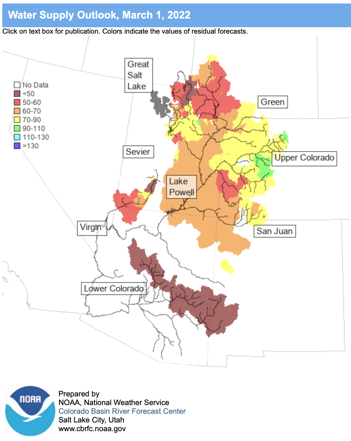
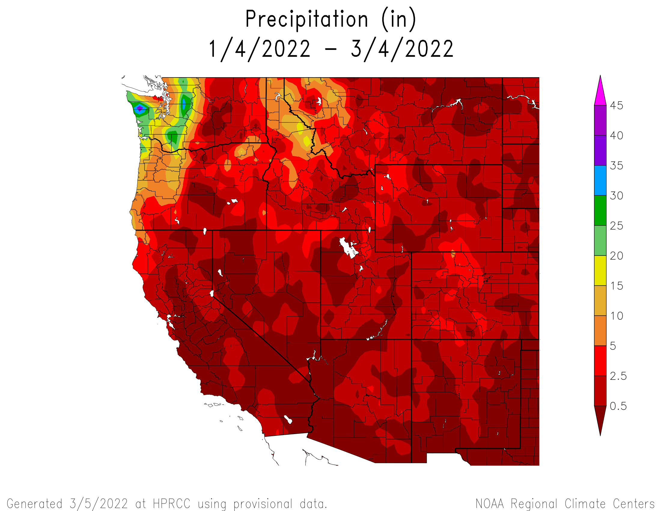
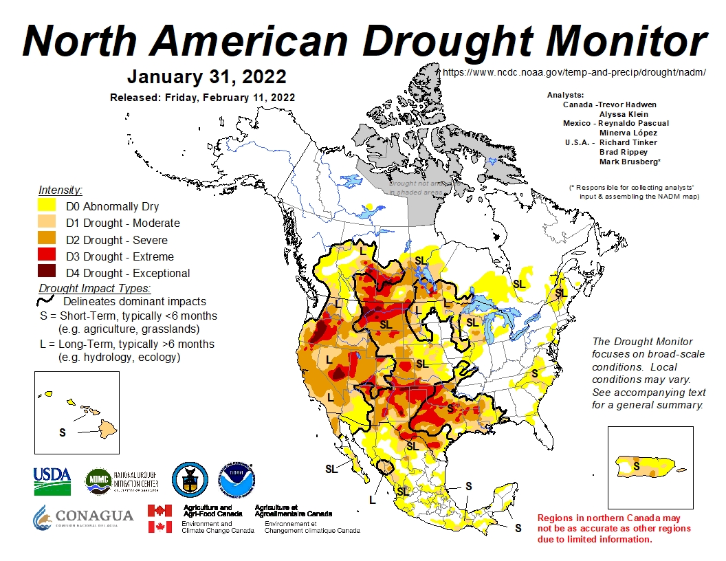
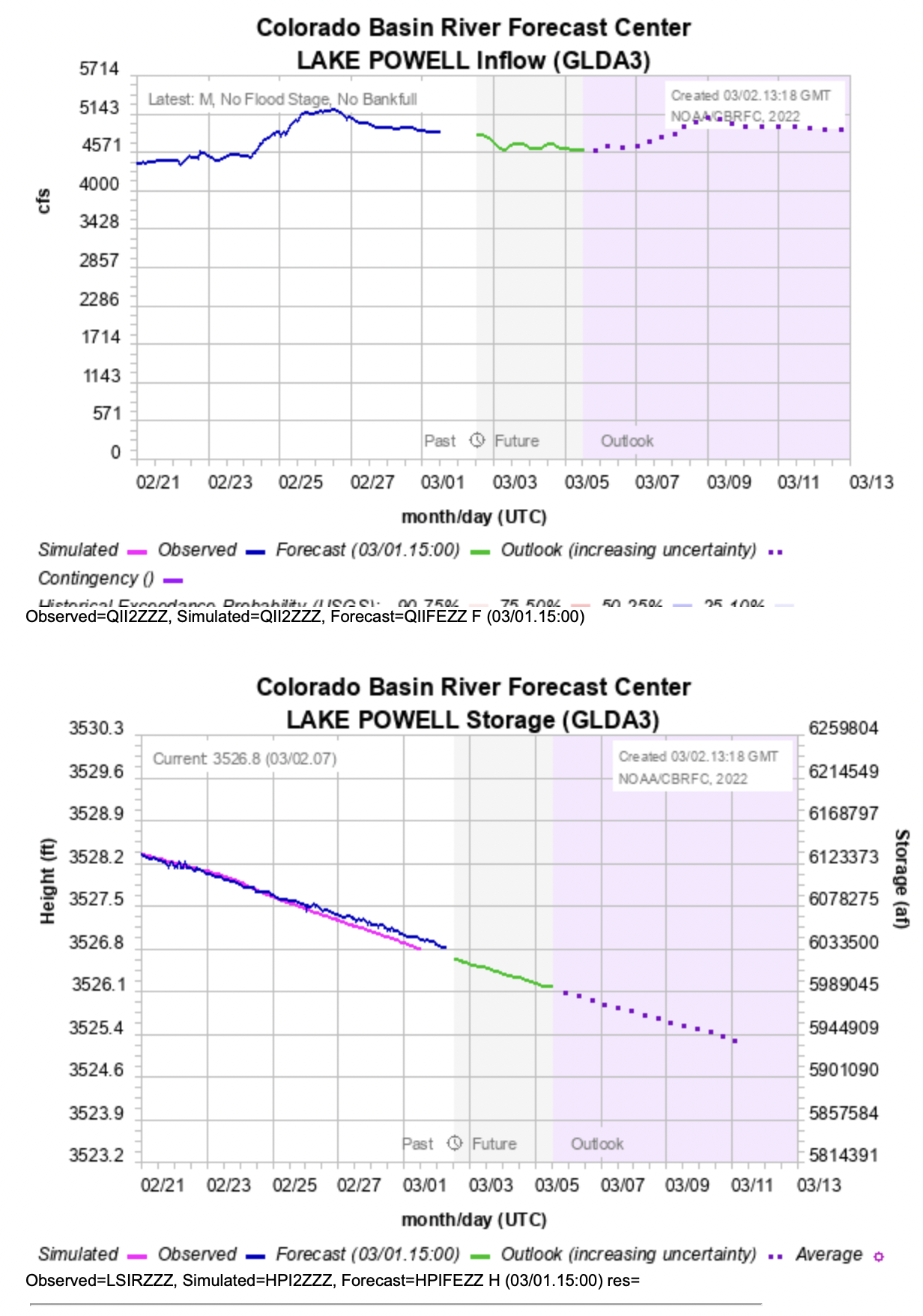
Dry conditions continued across much of the region during February and regional snowpack generally declined relative to normal despite below average temperatures. March 1st seasonal streamflow volume forecasts also declined compared to February 1st forecasts. Streamflow forecasts generally range from below normal to slightly above normal throughout the region and the inflow to Lake Powell is forecasted to be 72% of median. Drought persists across 97% of the region and extreme drought developed in northwestern Wyoming. Current La Niña conditions and NOAA seasonal forecasts suggests that significant alleviation of drought conditions will not occur during the remainder of winter.
February precipitation was below to much-below normal for most of the region. Large portions of Utah and western Wyoming received less than 50% of normal precipitation. Western Colorado, southern Wyoming and eastern Wyoming generally received 50-90% of normal February precipitation. Precipitation was slightly above normal in central Wyoming and up to 300% of normal in eastern Colorado.
Temperatures were below average during February in Colorado, Utah and Wyoming. In most of Utah and Wyoming, February temperatures were 2-4 degrees below normal and central to eastern Colorado saw temperatures that were 4-8 degrees below normal.
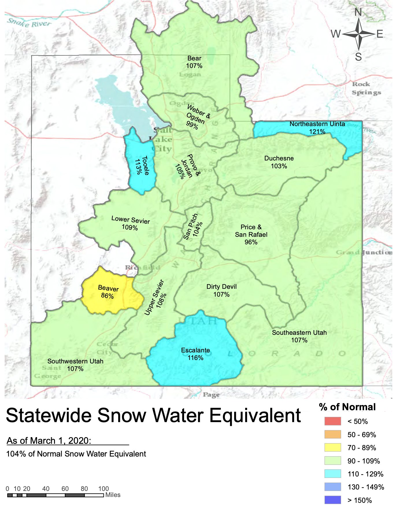
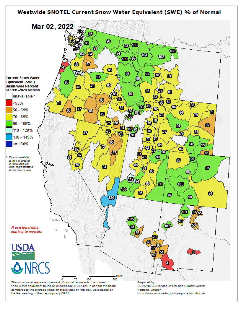
Regional snowpack continued to decline relative to normal and ranges from 62% to 106% of normal in regional river basins. Snowpack is deepest in Colorado with 95% of normal statewide snowpack. Statewide snowpack is at 82% of normal in Utah and 83% of normal in Wyoming. The largest declines in snowpack relative to normal during February were in northern Utah and western Wyoming.
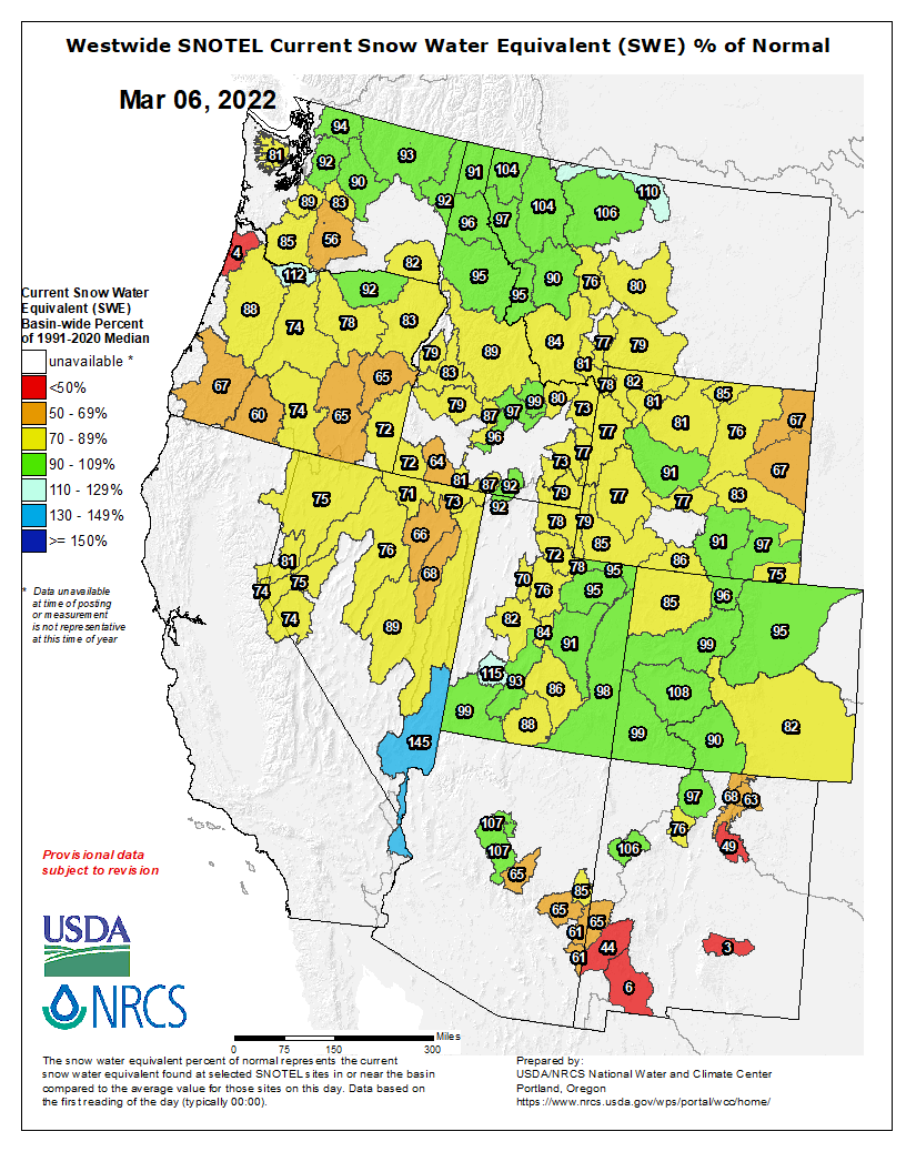
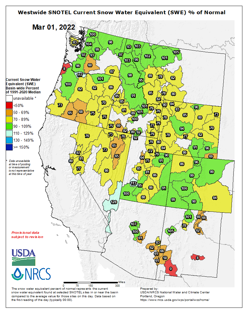
Westwide SNOTEL basin-filled map March 10, 2022 via the NRCS
March 1st seasonal streamflow volume forecasts range from much-below normal to normal across the region and decreased since February 1st for all regional river basins except the San Juan and Rio Grande Rivers which remained unchanged. Streamflow forecasts generally range from 55-135% of normal in the Upper Colorado River Basin, 50-11% of normal in the Great Basin and 50-110% of normal in Colorado and Wyoming east of the Continental Divide. The lowest March 1st seasonal streamflow forecasts were in the Bear, Dolores, Upper Green, Powder and Weber River Basins. The greatest decreases in season streamflow forecasts since February 1st were found in the Bear, Upper Green, Sevier, Six Creeks and Weber River Basins, roughly correlating to where February precipitation was lowest.
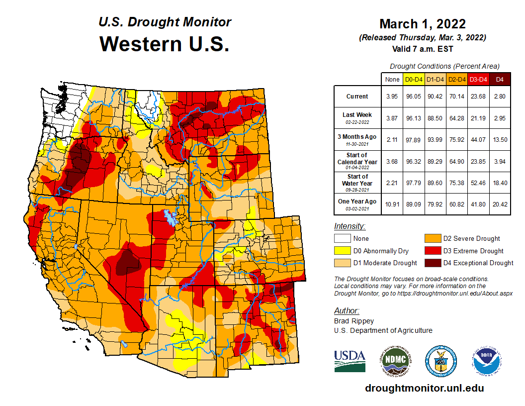
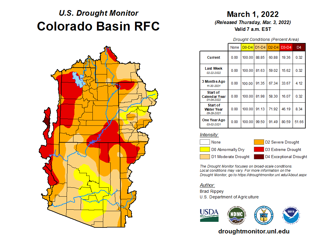
Drought conditions expanded slightly during February and now cover 97% of the region; extreme (D3) drought conditions continue to cover 18% of the region, but shifted in location. In Colorado, D3 drought was removed from the Eastern Plains and decreased in coverage in the Rio Grande River Basin. In Utah, drought remained unchanged except for a small area of improvement in southwestern Utah. In Wyoming, D3 conditions expanded in northeastern Wyoming and developed in the Teton and Wind River Ranges. Significant regional improvement in drought regional drought conditions seems unlikely during the remainder of winter.
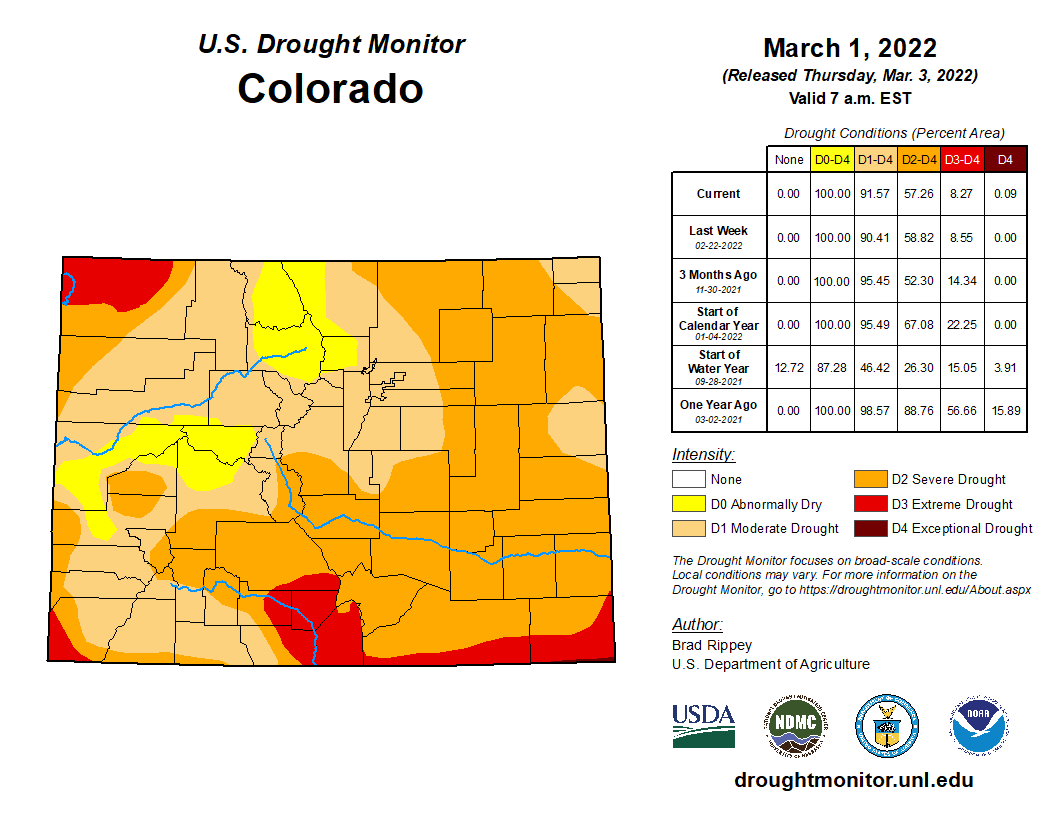
West Drought Monitor map March 8, 2022.
A La Niña advisory remained in effect during February and Pacific Ocean temperatures are currently 0.5-1ºC below normal. Weak La Niña conditions are projected to remain in place through March-May, but ENSO neutral conditions are likely to return by May-July. NOAA seasonal forecasts for March suggest an equal probability of below or above average precipitation for the region and an increased probability of below average temperatures for Wyoming and most of Utah. On the three-month timescale, NOAA seasonal forecasts predict an increased probability of below average precipitation, especially for the Four Corners region, and an increased probability of above average temperatures for the entire region except northern Wyoming.
Significant February weather event: Wyoming cold wave. On February 22-23, an extremely cold air mass dropped into the Northern Rockies east of the Continental Divide, causing a short-lived but intense period of cold temperatures across Wyoming and northeastern Colorado. A cold front arrived on 2/21 causing record low minimum and maximum temperatures on 2/22-2/23. Temperatures bottomed out at -34ºF at Lamar Ranger Station in Yellowstone National Park on the morning of 2/23. Considering weather stations with at least 50 years of data (there are 77 such stations in Wyoming), 16 record low temperatures were set on 2/22 and 21 records set on 2/23. Even more record low maximum temperatures were set with this cold wave. Record low maximum temperatures were set at 44 sites on 2/22 and 52 records were set on 2/23. While the cold wave was not as extensive in Colorado, many record low temperature records along the Front Range were also broken, including in Fort Collins, Boulder, Denver, Colorado Springs and Pueblo.
This month’s climate summary includes a monthly weather almanac which highlights climate extremes for the month of February in each state. This will be a regular addition to future monthly climate summaries.
Click the link to read the article on The Denver Post website (Conrad Swanson). Here’s an excerpt:
For a glimpse of the bigger picture across the American West, [Becky] Bolinger, also a climatologist with Colorado State University, pointed to the Lake Powell Reservoir, which is already at a record low.
“We’re not going to recover,” she said.
A drought like the one enveloping the West, which has lasted for two decades, needs much more than a single winter of average snowfall to bounce back, Bolinger said.
Colorado snowpack basin-filled map March 10, 2022 via the NRCS.
Snowpack data shows that accumulation around Gunnison and Ouray sit at 109% of normal levels, down from 148% in early January. Snowpack around Durango sits at 101% of normal, down from 137%. Levels around Aspen and Glenwood Springs are 100% of normal, down from 124% in early January and the area around Steamboat Springs sits at 88%, down from 115%, according to the data, collected by the U.S. Department of Agriculture’s Natural Resources Conservation Service. Snowpack around Denver sits at 96%, down from 114%…
Colorado Drought Monitor map March 8, 2022.
More than 90% of the state is considered to be in a drought, according to data released Thursday by the National Drought Mitigation Center. The rest of the state is still considered abnormally dry.
Potential Water Delivery Routes. Since this water will be exported from the San Luis Valley, the water will be fully reusable. In addition to being a renewable water supply, this is an important component of the RWR water supply and delivery plan. Reuse allows first-use water to be used to extinction, which means that this water, after first use, can be reused multiple times. Graphic credit: Renewable Water Resources
The decision to cancel the event came during a March 9 work session in which county staff told the commissioners they were expecting 300 to 400 people to attend and that it appeared a protest was planned to take place…
Commissioner George Teal, who has voiced his support for the project, said was in favor of canceling the meeting, adding that he had initially hoped to have “actual conversations” with residents and “get past the visceral, emotional aspects of this project.”
He said he’s heard from people in the valley who support the RWR project but feel they are being intimidated to remain quiet….Commissioner Abe Laydon, who has said he hasn’t yet decided if he supports the project, said he still wants to go to the valley but said the event had been “hijacked by a group of folks” and said he didn’t want to be part of it…Commissioner Lora Thomas, who has vocally opposed the plan, said she’s not interested in going to the valley…
When asked where the county learned of reports of intimidation, a county spokesperson referenced comments from a speaker during one of the commissioners work sessions on the topic — Jerry Berry, who is a farmer in the San Luis Valley and a representative for RWR…
In a Feb. 28 meeting, executive director of the South Metro Water Supply Authority Lisa Darling told the commissioners that none of the major water districts in Douglas County are interested in the water from RWR.
Synopsis: La Niña is favored to continue into the Northern Hemisphere summer (53% chance during June-August 2022), with a 40-50% chance of La Niña or ENSO-neutral thereafter.)
Below-average sea surface temperatures (SSTs) strengthened during February 2022 across the central and east-central tropical Pacific, with negative anomalies stretching from the central to eastern equatorial Pacific Ocean. In particular,the weekly Niño-3.4 index decreased from -0.6°C at the beginning of February to -1.1°C in the last week, while the other Niño SST regions were between -0.6°C and -1.3°C in the last week. Subsurface temperatures anomalies (averaged between 180°-100°W and 0-300m depth) were near zero, as the recent warming associated with the downwelling Kelvin wave has attenuated. Below-average temperatures have expanded near the surface and at depth near~150°W. Tropical atmospheric anomalies strengthened during the past month, with the extension of enhanced low-level easterly winds across the equatorial Pacific and upper-level westerly wind anomalies remaining over the east-central and eastern Pacific Ocean. Suppressed convection strengthened around the Date Line, while convection was enhanced near Indonesia. Overall, the coupled ocean-atmosphere system reflected the continuation of La Niña.
The IRI/CPC plume average for the Niño-3.4 SST index continues to forecast a transition to ENSO-neutral during the Northern Hemisphere spring. This month, the forecaster consensus favors a slower decay of La Niña due to the recent renewal of ocean-atmosphere coupling, which contributed to cooler near-term forecasts from several state-of-the-art climate models. For the summer and beyond, there is large uncertainty in the state of ENSO; however forecasters lean toward negative Niño-3.4 index values even if the index does not reach La Niña thresholds. In summary, La Niña is favored to continue into the Northern Hemisphere summer (53% chance during June-August 2022), with a 40-50% chance of La Niña or ENSO-neutral thereafter.
Several storm systems from the northern Rocky Mountains to the Midwest brought with them rain, snow, and even some severe weather this past week. Temperatures for the week were cooler than normal over the northern Plains and into the West. The coldest readings were in the northern Plains and upper Midwest, with departures of up to 9 degrees below normal. Temperatures were warmer than normal over much of the eastern U.S., with the greatest departures (12-15 degrees above normal) over Tennessee and Kentucky. Areas of the Midwest, central Plains and into the West did see above-normal precipitation this week with areas of Kentucky, Indiana, and Ohio receiving over 2 inches of precipitation during the period. The southern Plains and South continue to dry out. As spring approaches and dormancy is broken, impacts are already showing in these areas and drought intensification is widespread with quickly expanding extreme and exceptional drought areas…
Precipitation was mixed in the region as portions of Wyoming, South Dakota, Nebraska, and Kansas recorded rain and snow during the week, with the winter season being quite dry overall. Temperatures were cooler than normal over the Dakotas and into western Nebraska and Wyoming with temperatures 2-4 degrees below normal. Eastern Nebraska and most of Kansas were warmer than normal with departures of 5-7 degrees above normal. Most of the region did not have any changes this week due to the lingering dryness. Kansas did have some drought intensification with severe drought expanded over the north central part of the state and along the Oklahoma border. With long-term dryness over southwest Kansas, exceptional drought was expanded out of the southern Plains and into southwest Kansas. Extreme southeast Kansas did record enough precipitation for improvement to abnormally dry and moderate drought conditions…
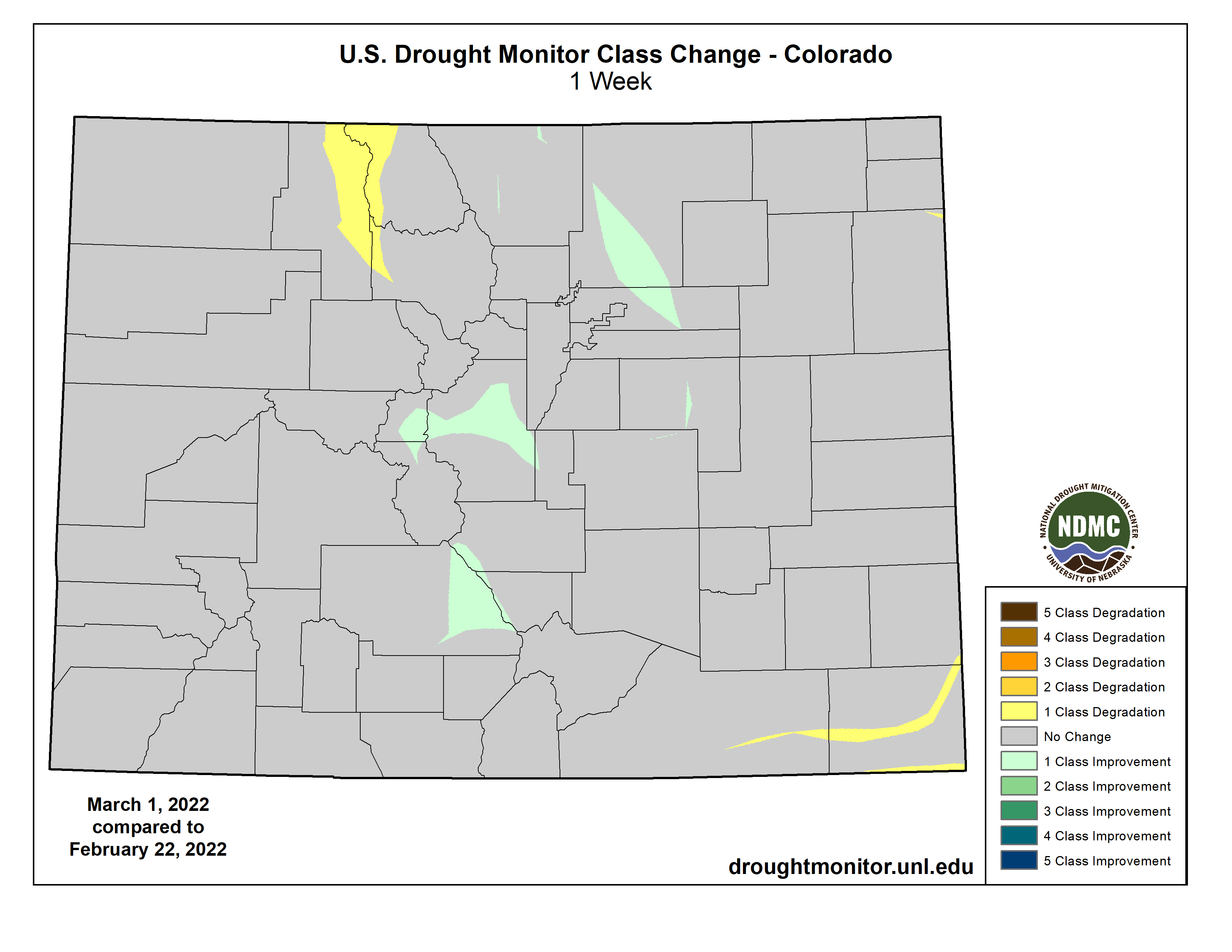
Colorado Drought Monitor Drought Monitor one week change map ending March 8, 2022.
Cooler than normal temperatures were common over the region with departures of 2-4 degrees below normal over much of the West. Some precipitation in the Rocky Mountains, central Utah and Nevada as well as the Pacific Northwest did help with seasonal snow values, reversing a dry trend that most areas have had. In California, there are many who fear that the snowpack has peaked for this season at 61% of normal, which will lead to further drought issues later on. Improvements were made to moderate drought and abnormally dry conditions in northern Idaho and western Montana. Northern Oregon had improvements to severe and extreme drought as well as to abnormally dry conditions. Extreme drought was expanded over portions of southern Oregon. Extreme drought was improved over northwest Colorado as both short- and long-term conditions were improving. A small area of moderate drought was improved over eastern Wyoming while moderate and severe drought were expanded over portions of southern Idaho. The dryness in the southern Plains is also impacting portions of southern and eastern New Mexico, where drought intensified this week. A new pocket of exceptional drought was added in southwest New Mexico while moderate and severe drought expanded in southern New Mexico and extreme drought expanded over eastern New Mexico…
Temperatures were warmer than normal over most of the region, with departures of 9-12 degrees above normal over Tennessee. Areas of northern Oklahoma and Arkansas experienced the only precipitation events in the region with above-normal amounts as most all of the region was quite dry. Degradation continued with drought status over the region. As dormancy breaks and green-up begins, water demand has increased along with warmer temperatures. Exceptional drought was expanded to cover more of the Oklahoma and Texas panhandles. Severe drought was expanded over western Oklahoma along with a new pocket of exceptional drought. A full category worsening of drought conditions took place over west Texas and much of central and east Texas as severe and extreme drought expanded. Mississippi and Louisiana also had widespread degradation with extreme drought expanded over most of southern Louisiana and along the Mississippi River into Mississippi. Moderate and severe drought were also expanded over much of central Mississippi and into southeast Louisiana. The overall pattern from the southern Plains into the South has been dry and warm conditions that will only lead to worsening conditions as spring arrives. The 4-month period from November to February was the 2nd driest such period for Louisiana since 1895 with less than 10 inches of observed precipitation statewide. With some good rains in Louisiana after the data cutoff for consideration this week, there may be some opportunities for improvements next week where the greatest rains occur…
Looking Ahead
Over the next 5-7 days, it is anticipated that cooler than normal temperatures will dominate the country, with departures of 9-12 degrees below normal over the Rocky Mountains and 3-6 degrees below normal over the Southeast. It is anticipated that the greatest precipitation will take place over the East coast, with local maximum amounts over southern Georgia and north Florida. Most areas are expected to record precipitation, with the northern Plains and California anticipated to be the driest.
The 6-10 day outlooks show that the likelihood of above-normal temperatures is greatest over the eastern half of the U.S., with the best chances over the Mid-Atlantic into the Northeast. Above-normal chances of below-normal temperatures are expected over Alaska. The best chances of above-normal precipitation are over the Pacific Northwest, Rocky Mountains and eastern U.S. Above-normal chances of below-normal precipitation are anticipated in the Southwest and northern Plains.
US Drought Monitor one week change map ending March 8, 2022.
The South Adams County Water and Sanitation district is one of several water providers around the state now treating to remove PFAS from its drinking water supplies. Nov. 23, 2021. Credit: Jerd Smith
The Colorado health department is investigating a contaminated underground plume issuing from land next to the Denver Fire Training Academy to determine whether it is responsible for high levels of so-called “forever chemicals” in the raw water supply of an Adams County water district that serves more than 65,000 people in the north metro area.
Photo credit: Denver Fire Department
The contamination was discovered in 2018, and since then, officials said, the City of Denver’s fire training center has stopped using the fire-fighting foam containing hazardous PFAS, or poly- and per-fluoroalkyl substances. The compounds have long lifespans and have been linked to certain cancers. Contained in such common substances as Teflon and Scotchguard, they are also widely used to fight fires.
A spokesperson for the fire academy declined to comment on the investigation and referred media inquiries to the Denver Department of Public Health and Environment, which said via email that it was working with the state to address the problem. It declined an interview request.
Jennifer Talbert, a hazardous materials expert overseeing the investigation for the Colorado Department of Public Health and Environment (CDPHE), said she expects the investigation to be done later this year, at which time decisions on how to clean up the contaminants will be made.
“They did discover PFAS within a certain region of the [fire academy] site, but we need to do more sampling and investigation. We’re developing the plume boundary now,” Talbert said.
The four contaminated wells owned by the South Adams County Water and Sanitation District were shut down quickly in 2018 after testing showed extraordinarily high PFAS levels, 2400 parts per trillion (ppt), in the raw water, according to Kipp Scott, manager of water systems at the district.
The U.S. Environmental Protection Agency’s health advisory standard for PFAS says levels should be no higher than 70 ppt.
Since then the state and the Tri-County Health Department have issued alerts to private well owners in the area, notifying them not to drink the contaminated water. Other residents in the region are served by the South Adams County district, whose water is being treated to reduce PFAS levels to 35 ppt, a level that is considered safe under the existing voluntary federal guideline.
Anyone concerned about potential contaminants in their drinking water can have free testing done.
The CDPHE’s Talbert said it hasn’t determined who is responsible for the contamination and won’t be able to do so until its investigation is finished.
But Scott said no other PFAS sources within the district have been identified other than those found at the fire academy, whose site is less than a half mile from the contaminated wells.
“We infer that that is the largest source in the area that is affecting our groundwater supply,” Scott said. “There are no other sources identified.”
Little was known about the unregulated PFAS chemicals in Colorado until 2015 when national news began appearing about their links to cancer, their prevalence in fire-fighting foam used at military bases and fire-fighting centers, and their presence in groundwater.
Two years ago, as more testing revealed more contaminated sites, the CDPHE vowed to boost its oversight. Since then the Colorado Legislature has provided the health department with more authority and money to combat the problem. CDPHE’s approach has included conducting surveys to identify contaminated sites and affected drinking water systems, spending as much as $8 million to buy contaminated firefighting foam and store it, and helping communities whose water has been tainted by the compounds with testing support and grants to help cover treatment costs.
Dozens of fire departments, military facilities, water utilities, and commercial properties as diverse as hotels and apartment complexes are now monitoring and testing for the substances.
As Colorado ramped up its oversight, last year the EPA announced it would begin work on a regulation that will, for the first time, set an official limit on PFAS compounds in drinking water. It is set to be available for public review this fall and would be finalized by the fall of 2023.
In the meantime, Scott said the South Adams County Water and Sanitation District has spent $5 million to build a sophisticated testing and monitoring lab, and to strengthen its treatment program enough to comply with the 70 ppt federal health advisory limit.
But that won’t be enough long-term to ensure its customers have access to safe drinking water, Scott said, so the district is preparing to install an advanced $70 million treatment system to reduce PFAS levels even further. That price tag is almost three times the size of the district’s annual $26 million budget.
“If the health advisory number should go lower, and we think it will, we don’t have enough capacity to go to a lower number,” Scott said. “And we need that raw water from the wells we shut down to meet future demand.”
Who will pay to correct the situation isn’t clear yet, but Scott said the cost should not fall on his district. “We’ve spent around $5 million treating for this contaminant that is in our water supply, and we did not put it there. But that $5 million cost is being paid by each one of our residents through higher rates and fees.”
CDPHE’s Talbert said cleaning up the contamination near the fire training facility and other sites will likely be complicated because the chemicals have never been regulated and, as a result, methods and technologies for clean-up are still being developed. But she said most residents in the region have access to treated drinking water through their water utilities.
“The science is new,” Talbert said,” and we don’t know the extent of the contamination. If we find that people have an exposure we will get them on bottled water and/or a reverse osmosis system.”
Jerd Smith is editor of Fresh Water News. She can be reached at 720-398-6474, via email at jerd@wateredco.org or @jerd_smith.
Click the link to read the article on the Westminster Window website (Luke Zarzecki). Here’s an excerpt:
The Intergovernmental Panel on Climate Change (IPCC) released their 2nd part of the Sixth Assessment Report, Climate Change 2022: Impacts, Adaptation and Vulnerability on Feb. 28. The report comes as a dire warning about the consequences of inaction, according to a press release from the IPCC.
“(The report) is essentially a literature review of all the science on this topic,” said Dr. Lauren Gifford, an Affiliate Faculty in the Department of Earth & Atmospheric Sciences at Metropolitan State University of Denver.
Locally, Gifford points to what she sees as a multi-decade drought hitting the Front Range. As well, the Marshall Fire, shifting ski seasons, the Boulder Floods in 2013, more frequent wildfires and the shortage of drinking water that can come from a changing climate.
Just a week earlier, the Westminster City Council nixed climate action from their strategic plan — a big mistake, according to Westminster City Councilor Obi Ezeadi….Both he and Gifford agreed that the evidence is apparent. Gifford studies the intersections of global climate change policy, conservation, markets and justice. She also assisted the 675 contributing authors, on top of the 270 regular authors from 67 different countries…
To shift away from a fossil fuel economy, she urges federal, state and local governments to step in, especially the federal government helping municipal governments who may lose tax revenue. For example, areas that depend on tax revenues from oil and gas would see revenues drop if production slows. That tax base, she said, goes to things like roads, infrastructure, schools and ambulances…
Gifford said that local municipalities play a huge role in combating climate change. Northglenn Mayor Meredith Leighty said their council keeps climate change at the forefront of their conversations while making decisions…
Mayor Jan Kulmann of Thornton — an oil and gas engineer as well — sees her city winning from addressing climate change from a business perspective…She points to increasing municipal electric vehicles, lighting structures to be less energy-intensive and changing yards to need less water.
Thornton City Councilor Julia Marvin would like to see a sustainability manager for the City of Thornton who would oversee a holistic, equitable perspective of sustainability with a dedicated budget. She is also in favor of subsidies for residents to install solar power…
Westminster completed a Sustainability Plan in 2021 with ambitious goals such as having 100% renewable electricity, 100% of residents living within a 10-minute walk of a park, 100% electric vehicles and 100% energy-efficient, healthy homes. These goals do not have a deadline, however…
[Max Boykoff] also recommended policies to help households switch over to heat pumps, commitments to tree planting and a carbon tax to help fund environmental initiatives and steer folks away from carbon.
For generations, farmers have relied on the spraying of herbicides to prevent invasive plants and weeds from choking their soybean, corn and wheat crops. But over the last several years, this tried-and-true system has been faltering.
Weeds are quickly evolving resistance to even the most advanced herbicides, including glyphosate – better known as Roundup – which was first introduced to farmers in the 1970s by agrochemical giant Monsanto. Herbicide-resistant weeds have brought farmers to their knees, desperate for solutions for protecting their crops.
Todd Gaines, an associate professor in the Department of Agricultural Biology, is one of weeds’ worst enemies. His expertise is in the molecular and genetic underpinnings of the most highly evolved superweeds of the world, with the goal of helping farmers target these foes with new, genetically precise and sustainable methods.
Palmer Amaranth in the Field. Photo credit: United Soybean Board
Gaines is now leading a project aimed at changing the game of weed control by using an entirely new mode of action to combat the most out-of-control weed species, king among them, a noxious, highly herbicide-resistant weed called Palmer amaranth.
Biotech company partnership
Gaines is partnering with biotechnology company AUM LifeTech to research the application and methods of an emerging gene-silencing weed control technology. Their method uses molecular tools called antisense oligonucleotides, which are next-generation single-stranded nucleic acid molecules, to infiltrate the cells of weed plants and target single strands of RNA. The molecular targets would be so specific that the crops would remain untouched.
Their goal is to optimize a delivery system in the form of a nanoparticle-based, shelf-stable spray. If they’re successful, their technology would give farmers a non-genetically modified, environmentally conscious tool to control weeds that are rapidly gaining the upper hand against legacy herbicides.
“This is the most exciting thing I have ever worked on in terms of promise,” Gaines said. “If we can solve this problem, this will be something every single person out there managing weeds will be affected by.”
He added that among his larger goals is to help make farming systems more sustainable, both by helping farmers maintain their livelihoods, and by making products that are safe for the public and the environment. “We need to help ensure we are not harming other organisms, while also managing these weeds.”
DARPA funding
Gaines and collaborator Veenu Aishwarya, founder and Chief Executive Officer of AUM LifeTech, are funded by the Defense Advanced Research Projects Agency for their two-year project, in which they will prove out the fundamental technology and test a delivery system.
Their system will focus on Palmer amaranth as a test case, a hardy and aggressive pigweed that exhibits extensive herbicide resistance and is a growing problem for commodity farmers. Its genome has been sequenced thanks in part to an international weed genomics consortium that Gaines also leads.
Antisense oligonucleotide technology is better known in life science applications because of its promise as a targeted therapeutic device for a host of diseases, including neurological and autoimmune disorders. But Aishwarya has long seen the potential for these single-stranded DNA molecules to be useful in agricultural settings, and he wants to expand his company in that direction.
“Since our gene silencing products use a non-GMO and non-permanent approach, this makes this technology very attractive for such applications,” said Aishwarya in a press release announcing the partnership.
A chance encounter with Gaines at an agricultural biotechnology conference several years ago paved the way for the partnership; now, AUM LifeTech’s proprietary gene silencing technology will form the basis of the RNA-targeting system he and Gaines will develop and test together.
“Todd’s work in collaboration with AUM LifeTech in RNA targeting to develop next-generation herbicides is an exciting example of CSU’s leadership in life science breakthroughs for agricultural applications,” said Alan Rudolph, vice president for research and a former program manager at DARPA. “The awarding of DARPA funds to address the intractable problem of herbicide resistance speaks to the extraordinary work of Todd and his team in developing new, molecular strategies to combat the worst effects of invasive plant species on our food supply.”
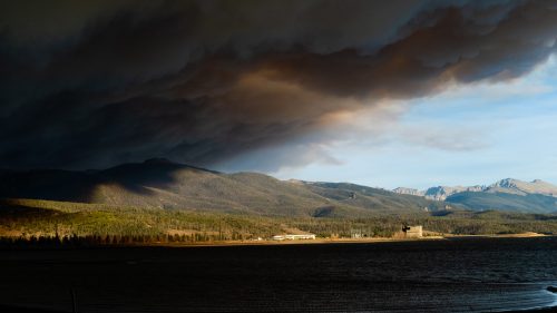
Smoke over Twin Lakes in Mono County, California, on January 24, 2022. Meteorological winter (December through February) was quite warm and dry across the U.S. as drought expanded across the parts of the West in February 2022, including California. (U.S. Forest Service)
Click the link to read the article on the NOAA website:
February continued 2022’s relatively dry start, with the majority of the contiguous U.S. in drought. The end of the month also ushered in the end of meteorological winter, which ranked as the nation’s 12th-driest winter in 128 years.
Here are more highlights from NOAA’s latest monthly U.S. climate report:
Climate by the numbers
February 2022
The average temperature across the contiguous U.S. last month was 33.8 degrees F, 0.1 of a degree F below the 20th-century average, ranking in the middle third of the climate record.
Below-average temperatures were felt across portions of the northern Plains, Great Lakes and from the central Rockies to the Gulf Coast. Temperatures were above average across portions of the West Coast as well as from the Southeastern U.S. to New England.
February’s average precipitation was 1.73 inches (0.40 of an inch below average), which ranked in the driest third of the historical climate record.
Above-average precipitation fell from the Mid-Mississippi Valley to New England, with Ohio seeing its sixth-wettest February on record. Precipitation was below average across most of the West and portions of the Plains, Southeast and Mid-Atlantic. California and Nebraska had their second-driest Februarys on record, while Nevada had its third driest.
Meteorological winter (December through February)
Meteorological winter was quite mild and dry across the contiguous U.S. The average temperature was 34.8 degrees F, 2.5 degrees above average, ranking in the warmest third of the winter record. Georgia and South Carolina saw their seventh-warmest winters on record, and no states ranked below average in warmth for the winter season.
Total winter precipitation was 5.76 inches — 1.03 inches below average — which ranks as the 12th-driest winter on record. Louisiana had its third-driest winter on record, Nebraska had its fourth driest and Kansas saw its fifth driest. Meanwhile, Minnesota had its 10th-wettest winter.
A map of the United States plotted with significant climate events that occurred during February 2022.
Other notable climate events
US Drought Monitor map March 1, 2022.
Drought tightened its grip: By the end of February, 59.2% of the contiguous U.S. was in drought, up nearly 4% from the beginning of February. Drought conditions expanded or intensified across portions of the northern and central Plains, as well as across parts of the West, Midwest, Great Lakes and from Florida to the Carolina coast. Drought severity lessened across portions of the southern Plains and across Puerto Rico.
A winter storm walloped many: A massive winter storm stretched from Texas to Maine during the first week of February and brought heavy snow, freezing rain, ice and bitterly cold temperatures to much of the eastern two-thirds of the contiguous U.S. More than a foot of snow fell across parts of the Northeast. Fallen power lines and trees caused power outages across many states, and thousands of flights were canceled amid treacherous travel conditions.
A record wet February and winter for Alaska: Alaska saw its wettest February in its 98-year period of record. Looking at some cities in the state, Juneau had its wettest February, following a record-wet January. King Salmon also saw its wettest February on record, while Anchorage ranked second wettest. February contributed to Alaska also seeing its wettest winter on record, eclipsing the previous wettest winter of 1928-29.
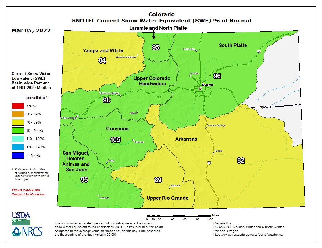
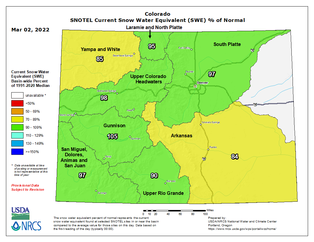
Largely due to the storms from late December, mountain snowpack and water year-to-date precipitation across major Colorado river basins remain near-normal (median). Currently, Colorado statewide snowpack is 96 percent of normal, ranging from a low of 86 percent in the Yampa-White-Little Snake to a high of 109 percent of normal in the Gunnison river basin. However, along with January, February precipitation for much of Colorado was far below normal. For example, the Colorado Headwaters has 95 percent of normal snowpack, but February precipitation was 63 percent of normal. Similar trends are seen in most of the central and northern basins. The southern basins in the state fared better with more February precipitation. It is important to note that percent of normal values have been updated from the 1980-2010 period to 1990-2020. More information about the normal updates can be found here.
Statewide reservoir storage is 75 percent of median. Currently, southwest Colorado has the lowest reservoir storage in the state with 61 percent of normal in the Gunnison and 64 percent in the combined San Miguel-Dolores-Animas-San Juan river basins. The highest reservoir storage is in the South Platte at 108 percent of normal. While not in the state of Colorado, it is worth noting the existing historic low conditions of Lake Meade and Powell which inevitably affect water resources and decisions for much of the Colorado river basin.
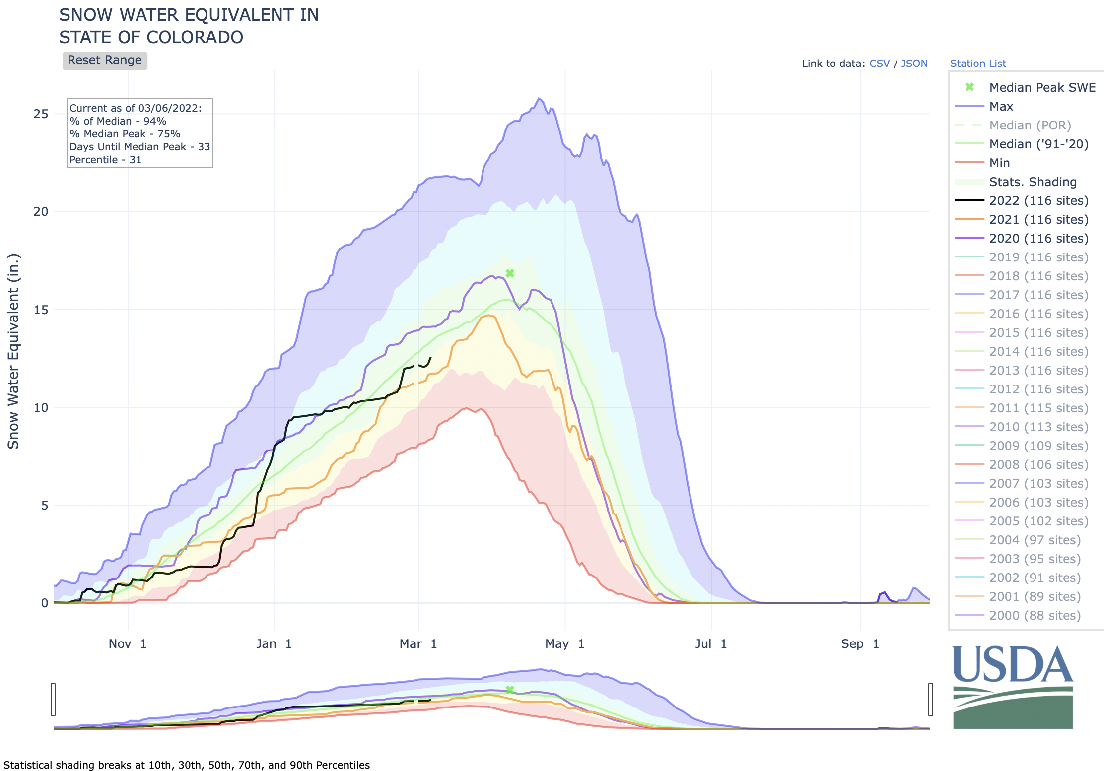
“While the snowpack remains near normal, it’s important to consider the antecedent conditions heading into this winter”, remarks Cole Greensmith, Hydrologist for the Colorado Snow Survey. Greensmith explains, “Several years of low summer precipitation, high summer temperatures combined with dry soils, suggest lower streamflow forecasts despite snowpack levels.” Current statewide streamflow projections are 88 percent of normal. The decline in streamflow forecast volumes is representative of lower precipitation levels in January and February combined with the long-term drought conditions. Historically, March is the snowiest month for Colorado, which we need to bolster the snowpack. If precipitation amounts do not increase in March through the rest of winter, we could be facing a truncated and below average streamflow runoff season this spring and summer.
Click the link to read the article on the Big Pivots website (Allen Best):
Legislators are considering how to nudge emissions from buildings, clean up Front Range air, and bring agriculture into the decarbonization effort
Conventional wisdom holds that politicians shy away from major initiatives in election years. Some think that is at play in Colorado this year. After all, inflation is at work, energy prices are rising, and analysts predict a rough election year for Democrats in Congress.
But if Colorado’s 2022 climate and energy legislative agenda certainly won’t match that of 2019, nor of 2021, it’s shaping up as an impressive year to advance the work on achieving economy-wide decarbonization goals of 50% by 2030 and 90% by 2050.
“This is probably not going to be a session filled with transformation legislation on climate change as 2019 and 2021 were, but there are some really good bills,” says Jacob Smith executive director of Colorado Communities for Climate Action, a coalition of 40 local governments.
An all-electric house. Credit: REWIRING AMERICA
Legislators are considering bills that seek to advance Colorado’s efforts to reduce emissions associated with buildings, clean up the crappy air quality along the northern Front Range, and bring the agriculture sector into the decarbonization effort.
Courtesy of Microgrid Knowledge
Others address microgrids, the potential for carbon storage, and funding for the state’s Office of Just Transition, the agency crafted in 2019 for coal communities and workers to reinvent themselves.
Legislators in 2019 adopted a remarkable set of bills that essentially pivoted Colorado’s energy system in a way that had never been done. Most prominent were the economy wide decarbonization goals.
Only 2004, when Colorado voters adopted the first renewable energy portfolio standard, comes close to the same pivot in energy.
The 2019 tsunami was made possible by heightened worries about climate change but also a shift in the Colorado Senate that gave Democrats majorities in both chambers. This came concurrently with the arrival of Jared Polis as governor after his campaign on a platform of 100% renewable electricity by 2040.
Then came 2020—and the covid shutdown, followed by the flood of even more powerful bills in 2021, including several that targeted methane from extraction to end-use in buildings. At least one of the ideas adopted in 2021 had been first proposed in 2007 but never got close to the finish line.
Now is catch-up time, a filling in of the gaps.
“Last year we essentially had two legislative sessions in one, and we accomplished a lot, and now we need to work on the implementation of it,” says Mike Kruger, chief executive of Colorado Solar and Storage AssociationThat won’t require as much legislation,” he points out. “That’s more regulatory work.”
Still, even as they waited the governor’s signature on many of the 30-plus bills that had been passed, state legislators indicated they knew there was still major work ahead. State Sen. Steve Feinberg, then the majority leader (and now the Senate president), said a major priority in the 2022 session would be legislation to improve air quality along the Front Range. Sen. Chris Hansen said he was thinking about how to integrate agriculture into Colorado’s decarbonization.
In September, Hansen revealed at a fundraiser that he intended to introduce legislation that would set interim decarbonization targets for Colorado. Those new targets—for 2028 and for 2040—are intended to create a steady trajectory for Colorado’s decarbonization efforts, to avoid the tendency to punt the decarbonization can down the road until a last-night cram session before the test.
When did Hansen decide this was needed?
“I think it was part of what I do essentially every summer and fall, which is really try to think about the important gaps, where they are and which ones, if you were to address them, you’d get the most bang for the buck when it comes to decarbonization,” said Hansen in an interview.
“So I’m always trying to think about that supply curve, of carbon abatement opportunities, let’s do the cheapest, easiest ones as fast as we can. And that is really kind of driving my policy development process.”
Meanwhile, in Boulder, State Rep. Edie Hooton was thinking about microgrids, and in Longmont, Rep. Tracey Bernett was thinking about both air quality and buildings.
Conservation groups sued the U.S. Surface Transportation Board, challenging its approval of a new rail line designed to quadruple oil production in northeast Utah’s Uinta Basin and send most of the crude to Gulf Coast refineries.
“It’s appalling that the board approved this climate-killing project and deeply undermined President Biden’s commitment to address the climate emergency,” said Deeda Seed, senior public lands campaigner at the Center for Biological Diversity. “We can’t make progress toward a more stable climate when our government keeps lighting fuses on giant carbon bombs. The board’s action completely ignored the pollution that will directly result from this filthy railway, and that’s illegal.”
Flanked by the Uinta Mountains to the north and the Book Cliffs to the south, the Uinta Basin of northeast Utah is a spectacular expanse of wild high desert with extensive public lands, open spaces, and unique fish and wildlife. Oil and gas exploitation in the Uinta Basin has already extensively damaged public lands, polluted the region’s air and water, and released massive amounts of climate pollution.
Today’s [February 11, 2022] lawsuit confronts the U.S. Surface Transportation Board’s failure to comply with the National Environmental Policy Act. In approving the Uinta Basin Railway, the Board failed to address the fact the proposed Uinta Basin Railway will spur increased oil production in the Uinta Basin — estimated at an additional 350,000 barrels a day — and carry up to 10 two-mile-long oil trains daily through the Colorado Rockies to the Gulf Coast.
“The Uinta Basin oil railway promises only economic and environmental ruin,” said Jeremy Nichols, climate and energy program director for WildEarth Guardians. “It will fuel more air and climate pollution, endanger clean water and undermine our transition to a clean and sustainable clean energy economy. While it may line fossil fuel industry executives’ pockets, it will leave Utahns and many others to shoulder the cost.”
The board ignored the fact that extracting and processing this oil would add 53 million tons of carbon dioxide per year to the atmosphere, conflicting with its December conclusion that the railway is in the public interest.
“We need a full accounting of the climate cost of fossil fuel infrastructure projects like the Uinta Basin Railway,” said Dan Mayhew, conservation chair for the Utah Chapter of the Sierra Club. “Millions of dollars of public money that could be funding social programs and municipal services are instead benefitting a select few fossil fuel extraction companies, without accountability to the local community. Utahns deserve accountability and an adequate analysis of the impact on our climate and communities.”
In 2020 conservation groups sued a Utah state agency for improperly diverting nearly $28 million in public funds from community projects to aid the oil railway. That lawsuit is pending in Utah district court.
In addition to climate damage, the railway will harm public lands, rare plants and wildlife habitat. According to a federal environmental analysis, the 88-mile-long railway would dig up more than 400 Utah streams and strip bare 10,000 acres of wildlife habitat, including crucial areas that pronghorn and mule deer need to survive. In Emma Park, a remote sagebrush valley known to birdwatchers, bulldozers and train traffic could drive imperiled greater sage grouse out of their mating and nesting grounds.
Today’s lawsuit also challenges the U.S. Fish and Wildlife Service’s failure to protect rare plants protected by the Endangered Species Act that the rail line will destroy.
“If ever there was a project to walk away from, this is it,” said John Weisheit, conservation director for Living Rivers in Moab, Utah. “Imagine all the expense and consumption to perform deep, horizontal drilling techniques, to bring a waxy crude to the surface. Then to transport that crude over sensitive landscapes, then process it at distant coastal refineries. And then ship all that oil to transoceanic markets. All of this, at every step, creates more climate disruption for our living communities.”
Nearly all the railway through Ashley National Forest in Utah — 12 miles with plans for five bridges and three tunnels — would be on public lands protected by the Roadless Area Conservation Rule. The oil trains would increase the risk of fires and oil spills along the route through Colorado, including the vulnerable Colorado River corridor. Ramped-up fossil fuel production in the Uinta Basin would likely increase smog in western Colorado.
“The proposed Uinta Basin Railway would harm all Utahns, as well as communities across the country and around the world,” said Jonny Vasic, executive director of Utah Physicians for a Healthy Environment. “The railway would roughly quadruple oil production in the Uinta Basin, resulting in dire consequences for air quality, public health, water use and quality, public safety and climate change.”
A train, with oil cars, moves along the banks of the Colorado River, downstream of Loma. Photo: Brent Gardner-Smith/Aspen Journalism
Click the link to read the article “Utah rail line could bring 10 crude oil trains through Denver daily, drawing concern across Colorado” on the Denver Post website (Conrad Swanson). Here’s an excerpt:
The proposed 85-mile line would allow drilling operations in northeastern Utah’s Uinta Basin to expand and connect to refineries in Texas and Louisiana, rolling through Colorado in the process, likely alongside Interstate 70 and the Colorado River. Work on the new line could begin as early as next year but the project faces new hurdles after Eagle County and several conservation groups sued to require a deeper environmental investigation. Dozens of other cities and counties in Colorado have also asked the state’s U.S. senators to intervene.
Drilling for more fossil fuels is the wrong move as the American West suffers from a decades-long megadrought, record-setting wildfires and other consequences of climate change, Glenwood Springs Mayor Jonathan Godes told The Denver Post. And rolling massive quantities of crude oil through the heart of his city, through the heart of the state, presents even more immediate risks…
Utah’s Uinta Basin is notoriously inaccessible, undeveloped and wild, Seed said. So a group of Utah counties, called the Seven County Infrastructure Coalition, proposed the rail line in 2019 to help companies move the waxy crude out of the basin and to expand drilling operations…
Eagle County officials agreed and sued the board in federal appeals court in Washington D.C., last month to try and force another environmental study…Ted Zukoski, a senior attorney for the Center for Biological Diversity, said his organization, alongside the Sierra Club and three other conservation groups also sued last month. Their case has since been consolidated with Eagle County’s, he said. Forty-two Colorado cities, 11 counties and 20 water sanitation districts also voiced their opposition to the project, asking senators Michael Bennet and John Hickenlooper to help stop the work.
After two years of virtual and hybrid gatherings, the Colorado River District will once again host in-person State of the River events across the West Slope throughout spring 2022. Twelve events across the 15-county River District will bring District staff, local partners, hydrologists, and water users together to discuss and address the most pressing water issues facing West Slope communities today.
Each State of the River event is hosted in partnership with a local organization, with each agenda designed to address local challenges and the regional issues affecting all Western Coloradoans. Cornerstone presentations will include river basin hydrology and water forecasts from state and federal experts, local water-related efforts by partner organizations, and opportunities for funding multi-benefit projects.
“Whether you’re an irrigator, angler, boater, skier, energy provider, or simply a West Slope resident, we all have a vested interest in water – it’s the common thread that binds us all,” said Marielle Cowdin, Director of Public Relations at the River District. “State of the River events not only bring water experts to your doorstep, they also bring the ear of the River District. Our staff wants to hear from you and understand your needs and concerns. Together, we can find innovative solutions for a hotter, drier future. We hope you’ll join us.”
All State of the River events are free and include a light dinner. Registration is required. Local events by river basin are below, with details to come for later dates. Find agenda details and RSVP links online at: http://www.coloradoriverdistrict.com/state-river-meetings-2022/
Map of the Colorado River drainage basin, created using USGS data. By Shannon1 Creative Commons Attribution-Share Alike 4.0
Click the link to read the article on the Westminster Window website (Luke Zarzecki). Here’s an excerpt:
The Westminster city council voted 5-2 on February 28, 2022 to lower water rates starting June 1, 2022. Councilors Sarah Nurmela and Obi Ezeadi stood opposed.
Councilors voted to change both the bracket for water used and the pricing tiers. For the city’s lowest pricing tier, the price per gallon was reduced and the amount of water used increased by 2,000 gallons. Previously, customers paid $3.96 per 1,000 gallons of water used per month for the first 6,000 gallons. Beginning June 1, they’ll pay a lower $3.57 per 1,000 gallons used each month for the first 8,000 gallons, according to Westminster spokesman Andy Le. Councilors had already made the price per gallon the same for the middle and top tiers, $8.15 per 1,000 gallons used per month. Now, councilors are reducing the middle tier’s price to $6.52 per 1,000 gallons and expanding the top limit. Previously, the second tier covered customers that used between 6,001 gallons and 20,000 gallons. Now, that tier will include customers who use between 8,001 and 40,000 gallons, Le said. The price per gallon for the top tier remains at $8.15 per 1,000 gallons used per month. But while the amount for that tier covered customers who used more than 20,000 gallons per month before, it covers customers who uses more than 40,000 gallons per month beginning in June…
According to the agenda, the move will result in approximately $4,100,000 in reduced revenues.
The reduced rates comes after a year of debate surrounding water. Former Mayor Anita Seitz and former city councilors Kathryn Skulley and Jon Voelz survived recall efforts because of their support of the previous water rates and tiers.
We’re partnering with GreenLatinos to spread the word about water reuse in Colorado, and how you can get involved in a proposed regulation. As the population in the state of Colorado increases, so do the demands on water resources. A variety of strategies are being implemented across the state to address projected gaps in water supply, and direct potable reuse (DPR) is one of those strategies. Join GreenLatinos and CDPHE to learn more about the technology and safe practice of DPR, and find out how you can get involved.
Colorado’s February precipitation failed to maintain Arkansas River Basin snowpack compared to the past 20 years. The U.S. Drought Monitor shows severe drought persisting in most areas in the basin with extreme drought in the southern edge of the lower Ark Basin in Colorado as well as the two western corners of Colorado (i.e., 9% of the state). The NOAA three-month temperature outlook projects higher than normal temperatures across all of Colorado through May. The three-month outlook also predicts lower than normal precipitation for the entire state.
Snowpack
The latest National Resources Conservation Service (NRCS) Snowpack Telemetry (SNOTEL) report shows basin-wide snowpack at 76% of median for snow-water equivalent (SWE) and precipitation at 83% of median. The highest snowpack readings continue to be recorded at Porphyry Creek (119%) and Saint Elmo (115%). Snowpack at Fremont Pass has dropped from 102% of median a month ago to a current reading of 90%. The Apishapa SNOTEL station reports 75% while the Hayden Pass station improved from 40% a month ago to 69% at present.
Reservoir Storage
Statewide reservoir storage was reported at 78% of average and 43% of total capacity during the February Governor’s Water Availability Task Force meeting. This link accesses the latest NRCS reservoir report, which is unfortunately producing suspect and incomplete data for February. The issue should be resolved soon.
River Flows
As of March 5, Arkansas River flows were 252 cfs at Granite, 393 cfs at the Wellsville gauge near Salida and 361 cfs at Cañon City. Below Pueblo Dam, flows were 64.9 cfs, increasing to 276 cfs near Avondale before dropping to 155 cfs near Rocky Ford. The flow was 1.64 cfs below John Martin Reservoir and 10.6 cfs at Lamar. Boustead Tunnel discharge rates were not available as of this writing.
River Calls
The Arkansas River Basin had eight active calls as of March 5. The Fort Lyon Storage Canal remains the calling water right on the Arkansas mainstem with a March 1, 1910, priority date. The Holitas Reservoir has a call on the Cucharas River with a March 20, 1901, priority date. The Upper Huerfano No. 2 is the calling structure on the Huerfano River with a priority date of March 15, 1869. The Model Ditch (March 20, 1862) continues its call on the Purgatoire River, as does the Tenassee Ditch (April 30, 1880) on the South Arkansas River. Additional calls are in place on Fourmile Creek and Greenhorn Creek. The Winter Water Storage Program ends March 14, which will likely impact calling water rights.
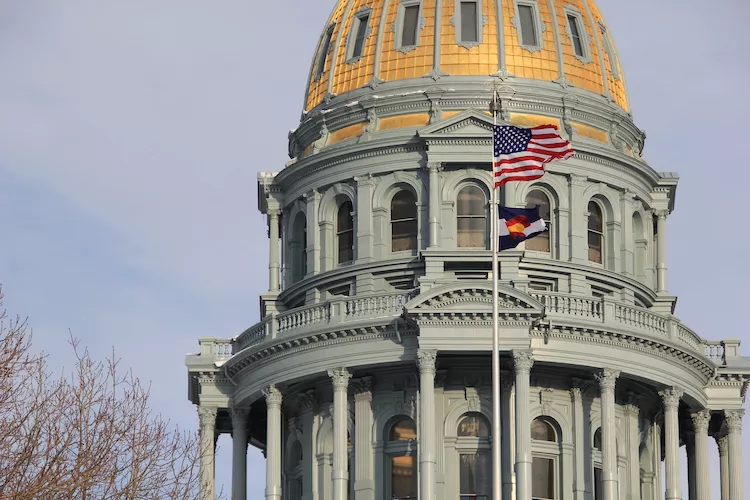
Colorado State Capitol. Photo credit: Allen Best/Big Pivots
Click the link to read the article on the Big Pivots website (Allen Best):
The inaugural members of the new Colorado Electric Transmission Authority have been identified. The board was created by a 2021 law, SB21-072 “Public Utilities Commission Modernize Electric Transmission Infrastructure.” It was authorized to select a transmission operator to finance, plan, acquire, maintain, and operate eligible electric transmission and interconnected storage facilities.
This new authority has been called the “transmission builder of last resort.” It’s preferable that utilities build transmission, but if they don’t, Colorado may have reasons for wanting the transmission. This may become important as Colorado looks to build out renewable energy in more difficult places currently lacking transmission.
One such place is the San Luis Valley, rich with solar potential, among the best in the nation, but lacking transmission capacity. Louis Bacon, who owns large land amounts in the area of La Veta Pass, the logical corridor for export, blocked plans by Tri-State Generation & Transmission in years past.
Another potential application is from Craig to Wyoming, the better to integrate Colorado’s electric resources into a regional transmission organization, or RTO, and tap the resources of other areas.
A third application may be in the cases of small utilities who need transmission but do not have the capacity to build it themselves. The vulnerability of Holy Cross Energy, for example, was exposed in 2018 when the Lake Christine Wildfire came within one already-burning wooden transmission pole of being able to provide power to Aspen during the July 4th weekend, typically one of the busiest of the year in that resort community.
The law specifies that the 9-member board is to consist of:
2 members appointed by the governor with the consent of the Senate;
the director of the Colorado Energy Office or his/her designee;
3 members appointed by the president of the Senate;
3 members appointed by the speaker of the House
The law also requires expertise among the appointees. For example, one must represent the interests of organized labor, another must have knowledge of renewable energy development, and one must represent the interests of commercial or industrial customers of electric utilities.
Those appointed to 4-year terms are:
Chris Caskey melds science and business in innovative new ways. He has a Ph.D. in applied chemistry from the Colorado School of Mines and worked at the National Renewable Energy Laboratory for a few years. It gets more interesting yet. He now operates Delta Brick Co. and has a lead role in Vessels Coal Gas, the company that operates the methane-to-electricity operation near Paonia. His resume is far more diverse than even this suggests. Oh, and he assisted a man attacked by an octopus.
Karl Rabago is the principal of Rabago Energy, a consulting firm. Before 2019 he directed the Pace Energy & Climate Center. His experience in energy goes back decades and includes such diverse stints as being a public utility commissioner in Texas to being an energy program manager for the Environmental Defense Fund.
Roger Freeman is an attorney who specializes in energy and environmental law. He is the chair of the board of directors for the Colorado Solar and Storage Association among other organizations. His father, the late Dyson Freeman, was a seminal thinker in the energy transition, and Roger Freeman has had pieces published in both the Sacramento Bee and in Big Pivots.
Michelle Zimmerman directs development at SunShare, with previous experiences in the renewable energy sector.
Rich Meisinger is the business manager for the International Brotherhood of Electrical Workers Local 111. He told Public Utilities Fortnightly Magazine in 2020 that the union has 4,225 members.
Leia Guccione is an engineer and now is the managing director of the Rocky Mountain Institute’s Carbon-Free Electricity division.
The RMI website says this: “Leia currently leads a body of work to inform utility regulators of policy solutions for a clean energy future, as well as provide them with unique process design and facilitation as they develop and execute reform initiatives to implement these solutions.”
Oh, and before joining RMI, she served in the U.S. Navy as a nuclear-trained surface warfare officer. She continues to serve in the Navy Reserves.
Kathleen Staks has is the director of Western Freedom, a group advocating for a regional transmission grid and briefly before that had a public relations firm. Staks was most recently director of external affairs for Guzman Energy, a new and disruptive wholesale power provider. Before that, she was executive director of the Colorado Energy Office during the administration of Gov. John Hickenlooper. She also held other posts in Colorado state government.
Will Toor manages the Colorado Energy Office. He has the authority to designate another individual from within his agency to be part of the authority’s activities. A physicist by training with a Ph.D., Toor previously worked for the Southwest Energy Efficiency Project, managing that organization’s transportation program, and before that was a Boulder County commissioner and mayor of Boulder. His life’s travels included spending part of one very cold winter in Moffat County as a sheepherder.
Tom Figel is the senior director of policy and business development at GRID Alternatives, a national organization devoted to the renewable energy transition as a way to drive economic growth and environmental benefits in communities most impacted by underemployment, pollution, and climate change. He manages the community solar program and leads utility relations and advocacy efforts for GRID Colorado. He has prior experience in marketing, strategy, and utility relations for software and battery storage startups.
An illustration of solar panels pulling water vapor from the air to grow crops | Credit: Renyuan Li/KAUST
Click the link to read the article on the Cell Reports Physical Science website (Renyuan Li, Mengchun Wu, Sara Aleid, Chenlin Zhang, Wenbin Wang, and Peng Wang):
Highlights
Recycle waste heat from PV panels to produce fresh water from the atmosphere
Cool down PV panel and increase its electricity generation performance
Integrated system (WEC2P) produces electricity with fresh water and crops
Application is with minimal geological constrain
Summary
Stable supplies of water, energy, and food are the most essential factors to universal achievements of the United Nation’s Sustainable Developments Goals (SDGs) by 2030. This work reports a self-sustained and solar-driven, integrated water-electricity-crop co-production system (WEC2P). The design of WEC2P is based on the atmospheric water adsorption-desorption cycle (1) to generate cooling power for photovoltaic (PV) cells to increase their electricity generation performance or (2) to sustainably produce fresh water from atmospheric water vapor to support crop growth. During the 3-month-long outdoor field test, the WEC2P successfully reduced the temperature of PV panels by up to 17°C and increased their electricity generation by up to 9.9% in the PV cooling mode. Meanwhile, it produced water to irrigate crops (i.e., water spinach) hosted in an integrated plant-growing unit in Saudi Arabia, with a crop surviving rate of 95%. Thereby, WEC2P may represent a meaningful contribution to the global water-energy-food nexus.
The Chaffee County Risk Mapping, Assessment and Planning (Risk MAP) Study is underway across the county through the Colorado Water Conservation Board (CWCB). The Chaffee Risk MAP Study will collect data on field conditions in areas of the county believed to be at risk for impacts from future flooding, erosion, debris flow, or related hazard events. This information will be used to update flood risk information and floodplain mapping in certain watersheds and create tools that provide a data-driven framework for land use and other decision-making in affected areas. The study is funded by the Federal Emergency Management Agency (FEMA).
Buena Vista
The Local Risk
Based on assessments performed for the 2021 Chaffee County Hazard Mitigation Plan, overall flood risk is an important consideration due to precipitation and snowmelt runoff, and is categorized as medium to high risk in most populated areas of Chaffee County. Countywide, an estimated $34.5 million in property losses is at risk to a one-percent annual chance flood hazard. The unincorporated areas of the county together make up the majority of this exposure, with an estimated $26.7 million in losses at risk. Of the municipalities in Chaffee County, Buena Vista is at the highest risk with $6.1 million in estimated losses in a one-percent annual chance flood, followed by Poncha Springs and Salida with approximately $1.1 million and $460,000 in estimated losses respectively.
Floodplain survey activities are currently planned between March and June
The survey work will be focusing on several flooding sources in all of the incorporated communities and the unincorporated county areas. According to the CWCB, the survey crews will be collecting elevation and other basic information on the land around the waterways being studied, and will not dig around nor disturb the areas…Wood and Merrick & Company are the floodplain mapping and field surveying contractors working with CWCB for Chaffee County’s study. Wood is also familiar with Chaffee County through their work with the 2021 update of Chaffee County’s Hazard Mitigation Plan.
Click the link to read the article on the Associated Press website (Sam Metz and Lindsay Whitehurst). Here’s an excerpt:
Utah — which is both one of the nation’s driest states and thirstiest consumers of water on a per capita basis — is among a larger group of states confronting the realities of prolonged drought and climate change, while also trying to prepare for population growth. The state relies heavily on the over-tapped Colorado River and its past plans to create infrastructure to siphon more river water have provoked a united outcry from other states in the region — Arizona, California, Colorado, Nevada, New Mexico and Wyoming. This year’s water focus is a detour from previous years for a growing state that has historically been one of the region’s most reluctant to curtail water use. Here are a few proposals on the table as lawmakers barrel toward the end of the , legislative session:
SECONDARY METERING
In Utah, about 200,000 homes and businesses have access to essentially unlimited outdoor water in exchange for a flat fee. It’s considered some of the cheapest water in the country. This year, lawmakers approved a plan to spend about $250 million in federal funds to rein in what’s called “secondary metering” and install meters on those connections so the amount of water they used can be measured for the first time…The proposal would require all secondary water connections to have water meters by 2030, though some small rural areas would be exempted.
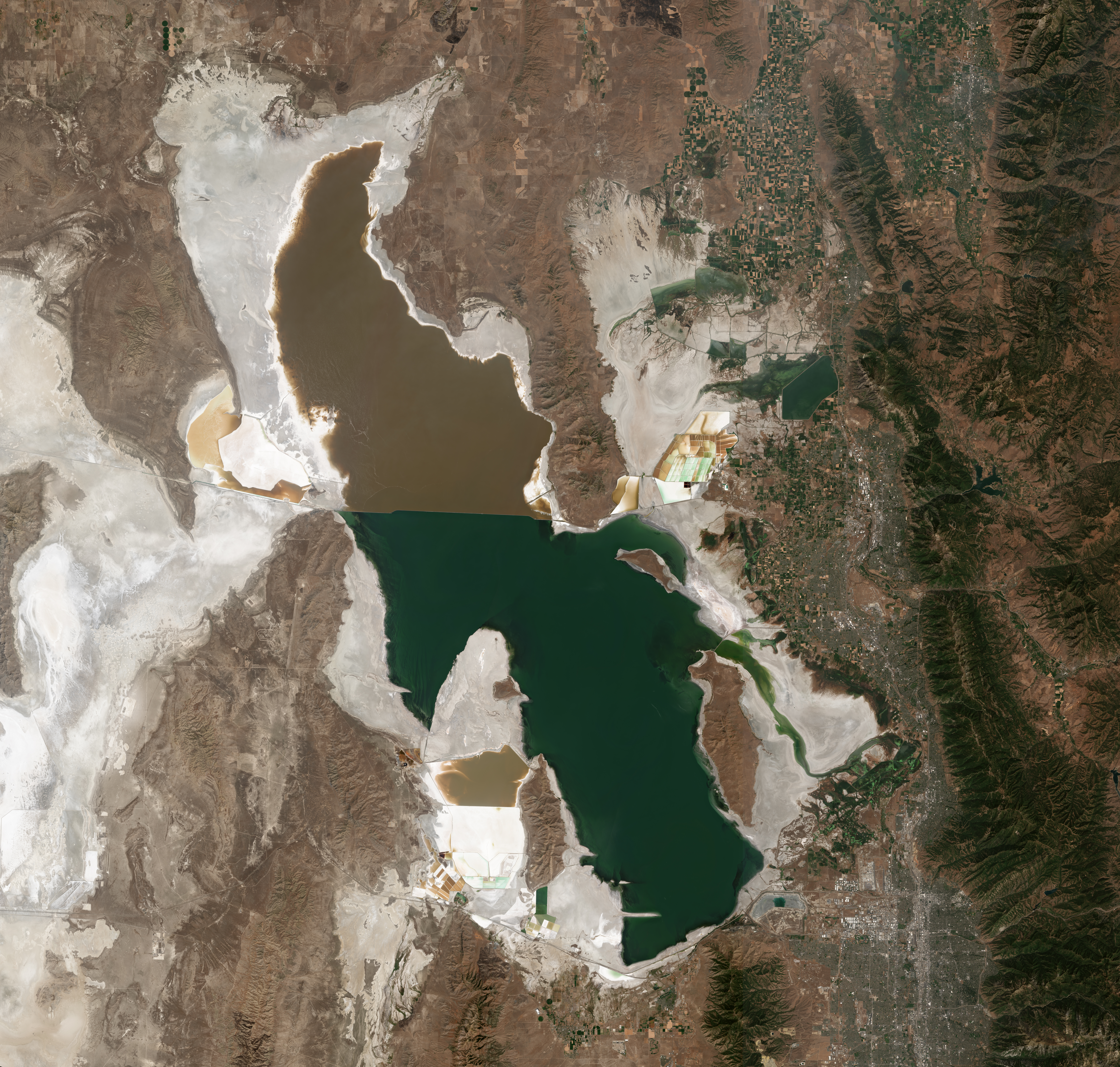
Satellite photo of the Great Salt Lake from August 2018 after years of drought, reaching near-record lows. The difference in colors between the northern and southern portions of the lake is the result of a railroad causeway. The image was acquired by the MSI sensor on the Sentinel-2B satellite. By Copernicus Sentinel-2, ESA – https://scihub.copernicus.eu/dhus/#/home, CC BY-SA 3.0 igo, https://commons.wikimedia.org/w/index.php?curid=77990895
GREAT SALT LAKE
Republican House Speaker Brad Wilson’s plan to set aside $40 million for a trust to save the Great Salt Lake got final approval this week and awaits signature from Gov. Spencer Cox. The proposal would focus on ways to get more water into the shrinking lake, which hit its lowest level in recorded history last year. It would also seek to improve the water quality and restore the wetlands around the lake. The initial investment of state money is considered a first step. It’s expected to be funded with a combination of additional public and private funds in the future, Wilson has said. He cited copper company Rio Tinto’s 2021 decision to donate water rights to the lake as an example of what the trust could facilitate…
The Southern Nevada Water Authority offers rebates of $3 for every square foot of grass replaced with water-smart landscaping. (Source: Southern Nevada Water Authority)
‘FLIP YOUR STRIP’
Utah lawmakers are poised to pass new laws to encourage people and businesses to replace thirsty grass with drought-tolerant landscaping that uses less water. A proposal from Ogden Republican Rep. Ryan Wilcox would prohibit cities, counties and homeowners’ associations from requiring residents to plant traditional grass yards, rather than “water-wise landscaping” such as mulch, rocks and plants that can be sustained with drip irrigation, not sprinklers. Homeowners’ associations, including in Sandy and Salt Lake City, require residents to maintain grass yards. Cities including Orem and Saratoga Springs have similar municipal ordinances. Wilcox’s bill passed the House in February and awaits a vote in the Senate. Republican Rep. Robert Spendlove wants the government to set an example in conservation. A bill he’s sponsoring would require agencies to conserve water through limiting how much grass they can plant around state-owned buildings and requiring they scale down their water consumption gradually in the next four years. It cleared the Senate Wednesday.
Prior appropriation example via Oregon.gov
‘USE IT OR LOSE IT’
Lawmakers are also aiming to reform a water law doctrine known as “use it or lose it” that jeopardizes property owners’ water rights for water they don’t consume, in effect, discouraging conservation. Historically in Utah, unused water that flows past cities and farms and into the Great Salt Lake has been considered “wasted” since the body is too salty for fish or most other aquatic creatures to survive. A plan from Republican Rep. Joel Ferry would allow farmers to let water flow downstream to the Great Salt Lake and other water bodies without the risk of losing their water rights — and get paid for it. Farmers would decide whether to sell their water, likely based on their harvests and balance sheets for the year. It awaits the governor’s signature.
Lake Powell Pipeline map via the Washington County Water Conservancy District, October 25, 2020.
DAMS AND PIPELINES
In their roughly $25 billion proposed budget, lawmakers did not earmark funds for two contested water projects in northern and southern Utah. Senate President Stuart Adams and Sen. Jerry Stevenson said Wednesday that the budget did not include provisions funding dams along northern Utah’s Bear River. The dams would allow more water to flow to the growing population of the Wasatch Front, but potentially divert water from the largest tributary that feeds the Great Salt Lake. The budget also does not include funding for the Central Iron County Water Conservancy District, which wants to construct a pipeline to transport additional groundwater to Cedar City and the growing surrounding areas.
Click the link to read the article on The Fort Collins website (Miles Blumhardt). Here’s an excerpt:
Statewide snowpack Friday was at 92% of average, but a snow-laden storm brewing for the weekend carried the promise of 10-20 inches of snow in the state’s northern mountains…But just how much more than 100% snowpack does Colorado need to soak the dry soil and still have enough for adequate river flows come spring and summer? State climatologist Russ Schumacher said there isn’t a magic number just yet, but the Colorado Climate Center and others are working on figuring it out.
“A lot of people are asking that question, especially the last few years,” he said. “But we don’t have a simple number right now where we can say we need 110% or 120%.”
[…]
Schumacher said a La Nina pattern still exists in Colorado. Historically, La Nina springs tend to be drier and warmer than average, which can further complicate matters. He said last year, which also was a La Nina year, saw warm and dry conditions in April surrounded by wet weather in March and May, blunting April’s impact.
Colorado snowpack basin-filled map March 5, 2021 via the NRCS.
The Bear, Weber, Provo-Jordan and Tooele Valley basins are looking especially bare, with snowpacks below 80% of normal according to the latest Water Supply Outlook Report by the U.S. Natural Resources Conservation Service. Statewide, snow water equivalent is at 82% of normal and February brought only 34% of its usual precipitation. Still, Utah’s precipitation is hovering right near average for this time of year at 101%, mostly due to early-season storms in October and December.
…the state will need an additional 13 inches beyond the historical water year average to eke itself out of years of accumulated shortages, NRCS reports.
Reservoir storage in the state is at 53% of capacity, down 14% from this time last year. And NRCS is predicting a dismal runoff season — with some streamflows as low as 20% of normal — unless more winter storms roll in.
Click the link to read the article on the Circle of Blue website (Brett Walton). Here’s an excerpt:
Climate Impacts Are Accelerating
The water cycle is speeding up. Warming temperatures are causing rapid shifts between wet and dry, flood and drought.
These impacts are not linear — they accelerate with more warming. Unless people adapt to rapid environmental change and greenhouse gas emissions are slowed, the risks to biodiversity, water security, food production, infrastructure stability, and health are much higher toward the end of the century.
Fish Creek Road after September 2013 floods via YouTube.
We’re Making Them Worse
Cities blanketed with pavement. Homes built in flood plains. Forests uprooted for cattle grazing. Rivers and lakes overloaded with nutrients.
Climate change is bad enough, but human actions are making the fallout worse.
Hard surfaces and channelized rivers increase flood peaks. New developments in flood plains put more people at risk of high waters. Cutting down trees in Brazil’s Amazon region is threatening to destabilize moisture feedbacks that nourish the iconic rain forest. Warmer lake temperatures mean less dissolved oxygen in the water and more algae blooms, which are a problem for fish and swimmers, as well as for drinking water systems.
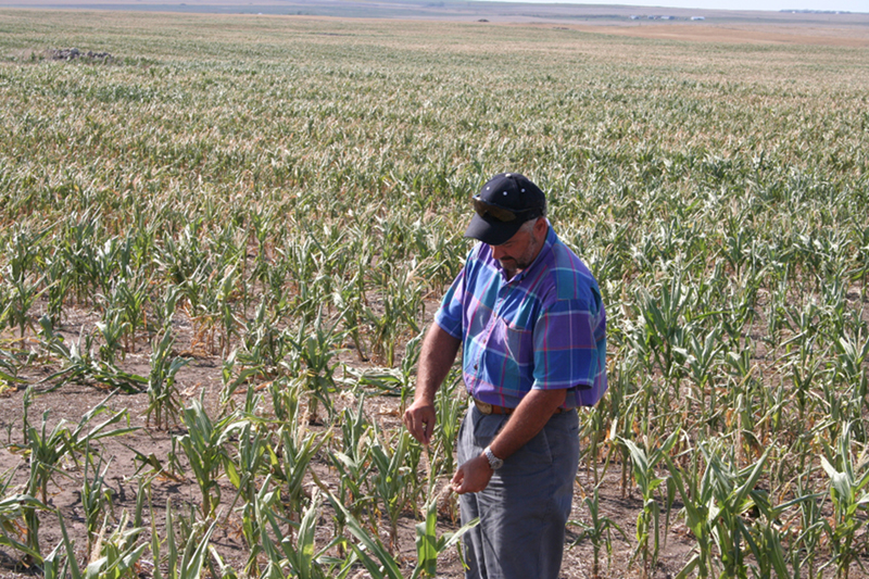
Drought impacted corn. Water stress can lead to insufficient water supply for cities, agriculture, and vegetation. Dry vegetation may facilitate the propagation and increase the risk of wildfires.
Food and Water Security Are in Jeopardy
Warming temperatures are melting the world’s glaciers, causing an irreversible loss of high-mountain water storage. Rising seas are pushing salt water into coastal aquifers, spoiling a source of fresh water for hundreds of millions of people. Rainfall in the Mediterranean and U.S. Southwest is becoming more variable. All these changes in water supply are a major stressor for the sector that consumes more water than any other: agriculture. Warmer temperatures and more severe droughts are already slowing the growth in crop yields.
Denver smog. Photo credit: NOAA
Human Health Is At Risk
Vector-borne diseases like malaria and dengue fever are expected to increase as mosquitoes expand their range outside the tropics. Droughts and floods are forcing people to flee their homes. Meanwhile, extreme weather like the Millennium drought in Australia has been shown to trigger anxiety and worsen mental health.
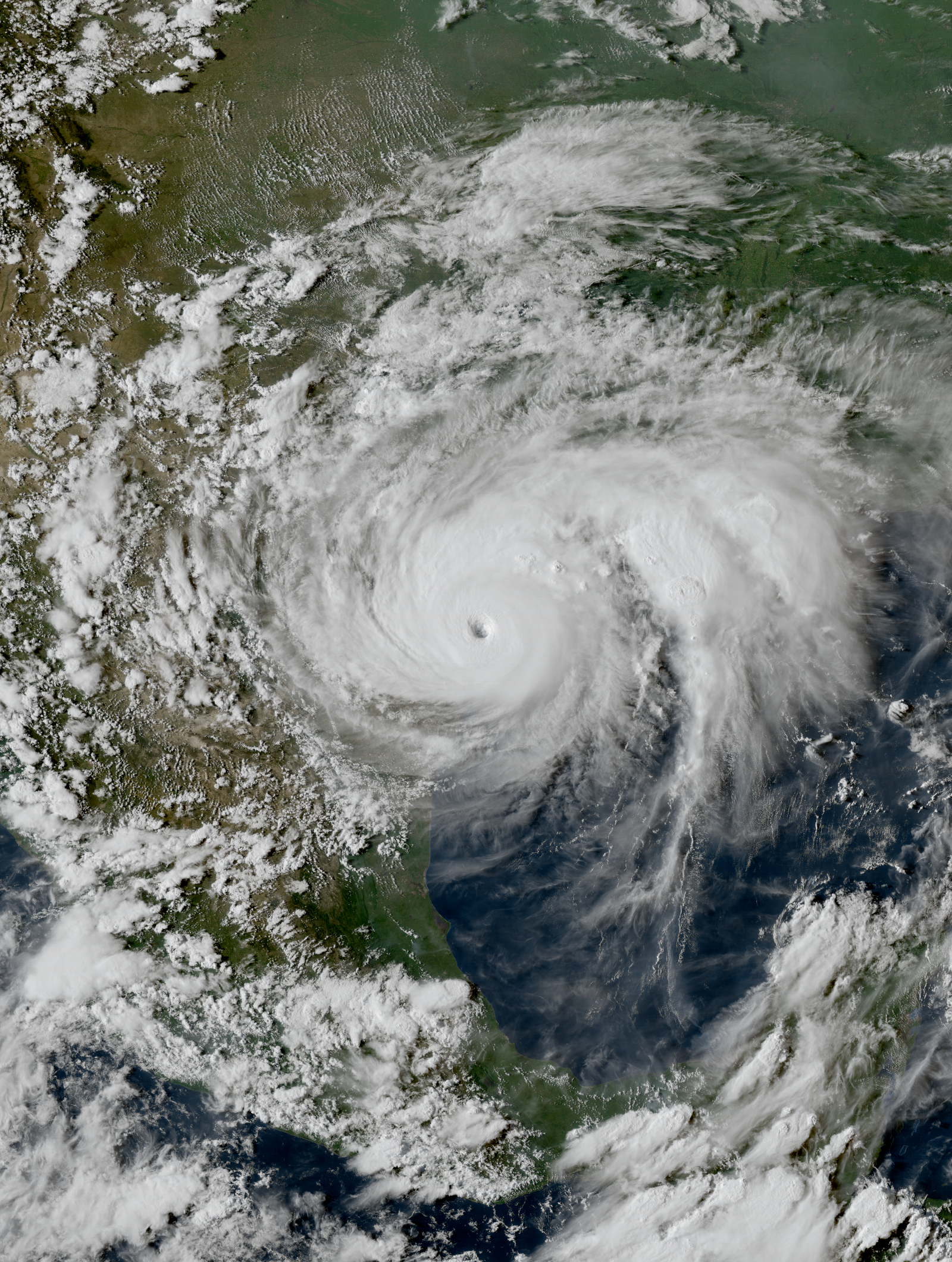
Hurricane Harvey near the coast of Texas at peak intensity late on August 25, 2017. By ABI image captured by NOAA’s GOES-16 satellite – RAMMB/CIRA SLIDER, Public Domain, https://commons.wikimedia.org/w/index.php?curid=61938876
Some People Are More Vulnerable Than Others
Not all people are exposed to the same level of risk. Vulnerability is higher in high-poverty areas, in countries with poor government, and in farming and fishing communities that are more exposed to climate change. The report notes that these vulnerability hot spots are clustered in Africa, South Asia, Central and South America, and small islands like those in the South Pacific.
Those discrepancies can be illustrated in numbers. Between 2010 and 2020, the death rate from floods, storms, and droughts in high vulnerability areas was 15 times higher than in low vulnerability areas.
Denver School Strike for Climate, September 20, 2019.
There Is Still Time to Act
The report authors were careful to note that the worst potential outcomes of climate change are not a foregone conclusion. There is still time to reduce carbon emissions — though scaling up a low-carbon economy requires marshalling political will, public support, technical expertise, and financing.
The same factors apply to adaptation, especially to water.
Crew foaming YCC dormitory at Mammoth Hot Springs during 1988 Yellowstone fire, image taken by Jim Peaco, September 10, 1988 and retrieved from the following page [1] of the Yellowstone Digital Slide Files archives which are all in the public domain
With a lack of regulations addressing toxic “forever chemicals,” students and professors at a Vermont college have taken their research skills into communities to spur action.
Wherever you look for PFAS, you’ll find them.
“They’re on Mount Everest; they’re in the Mariana Trench; they’re in polar bears; they’re in penguins; and they’re in just about every human population on Earth,” says David Bond, a cultural anthropologist and professor at Bennington College, who’s been investigating the “forever chemicals.”
PFAS (perfluoroalkyl and polyfluoroalkyl substances), a family of chemicals that includes PFOA and PFOS, are widely used in the manufacture of plastic products like non-stick pans, food packaging and waterproof clothing, and are also a component of firefighting foam.
Their non-sticky, nonreactive properties made them appealing to plastics manufacturers. But they’ve proved a nightmare for environmental health because they don’t break down quickly, if at all. They also travel long distances and bioaccumulate in plants, animals and people. Traces of the chemicals — many known to be harmful — are now found all over the world.
Seven years ago water tests revealed PFAS in Hoosick Falls, New York, just down the road from Bennington College. Bond, along with a small team of other professors at Bennington, began engaging students and community members in an effort to understand the extent of local PFAS contamination — which he later learned even included his own backyard.
They’ve since extended their work to other areas — helping to generate research that’s given communities a weapon to fight back against polluters and push for stronger regulations.
The Revelator spoke with Bond, who also serves as the associate director of the Elizabeth Coleman Center for the Advancement of Public Action, about the dangers of PFAS, why regulators have been slow to act and the power of a real-world education in environmental justice.
You’ve studied the effects of fossil fuels on communities for years. How did you get involved with PFAS?
PFAS came to us. In Hoosick Falls, New York, which is about seven miles from us at Bennington College, a resident discovered high levels of PFOA in drinking water in 2014. The state was unsure of what to do and actually put out a sheet for residents that said that PFOA was detected in the water over the level that the EPA had issued a health concern for, but residents could continue drinking the water and there was nothing to worry about.
So this caused a lot of alarm and residents reached out to me and asked if I would help them understand what was happening. I quickly enlisted a chemistry professor and a geology professor to join me.
We realized that one of the things that we do — teach — could be put in the service of this sort of unfolding toxic event. So we put together a classroom that was free for the community — anybody could come and take that class to learn about the contaminants, the health concerns, and what sort of things were available to help protect themselves.
What was the response from the community? And what did you learn together?
We had about half students and half community members in most of the classes. In 2015 [when we started] it was really just an emerging issue and there wasn’t a lot of reliable information. There were three plastics plants in town that were suspected and found to be the sources of the contamination. The state set up a perimeter around [them] and wasn’t willing to test beyond that perimeter.
But in our class people would say things like, “I live outside town, but every night for a few years, a truck would come up my road with a bunch of barrels and it would come back down the road in the middle of the night with no barrels. I wonder if there’s a dumpsite there.”
And so we would put together a little research question and go up and take some samples from surface water and groundwater where they had identified [potential problems] and see what we found. And a handful of times we came back with really high levels that we then turned over to the state and asked them to expand the perimeter. That perimeter kept expanding.
Eventually what we identified was an area of about 200 square miles that was contaminated with PFOA — way above what you’d expect in that area — that we could trace back to the plastics factories.
It took the state a very long time to start thinking at that scale. But we were able to because we were talking to people, listening to what they said. This is what anthropology is good at — listening to people. And [because we] partnered with a chemist and a geologist, we had all the tools you need to take people seriously and really test what they were telling us.
What’s been the impact of this work?
The students have gotten really engaged with this issue. It’s not something that you study in a textbook yet. It’s an unfolding problem and it’s happening next door. We brought our neighbors into our classroom, and we got out and went into our neighbors’ houses and started working together with them. And the students have been really taken with this model of learning.
I’ve also just drawn tremendous inspiration from how the community has insisted on justice for them. I’m not just working with them, I actually live there. PFAS was found in my own garden.
With this class of chemicals there’s no going back to before — the contamination is so extensive. There’s no way to remediate 200 square miles of this contaminant. It means that people are going to be carrying a lifetime of medical worry.
We know that trace exposure to these chemicals on levels of parts per trillion — which is almost impossible to get your head around how small that is — is strongly linked to a number of developmental dysfunctions, immune issues, and a host of cancers. Folks know these chemicals are in our community. We were exposed to them for decades. That means we’re going to have a pattern of health impacts over the long haul. So they’ve been really proactive at insisting that medical monitoring be part of any settlement with the polluters.
That sets up a kind of infrastructure where all the local doctors and nurses are on the lookout for all of the health issues that are known to be associated with exposure to these chemicals. And most of these issues — if they’re caught early — they’re very treatable.
Folks have also insisted on filtration systems for everybody’s water — this stuff is probably going to be in the groundwater for millennia.
After working in Hoosick Falls, you’ve extended your work to other communities. What else have you found?
In the last few years we’ve gotten a number of requests, and each time we try to figure out what we can do to help and how we can put the scientific resources of a college to work helping the public understand the PFAS issue and equip them to be better citizens and pursue environmental justice.
The last one that we got involved in was the incineration of PFAS. As it’s becoming clear that they will likely be designated as a hazardous waste substance, those who are sitting on stockpiles of these chemicals will soon have a huge liability on their hands. So the Department of Defense and the petrochemical industry have all rushed to start trying to incinerate stockpiles of PFAS.
This is worrisome because there’s no evidence that incineration destroys these chemicals. They’re fireproof toxins and are used in firefighting foam extensively. It’s a bit of a harebrained notion that you can burn them to destroy them.
A public housing complex in Cohoes, New York got ahold of us two years ago. It’s next to an incinerator. They had gotten word that it was suspected to be incinerating a tremendous amount of what’s called AFFF [Aqueous Film Forming Foam], which is a firefighting foam that’s made mostly of PFAS chemicals.
We took some samples of soil and water around that incinerator and analyzed them. We found a fairly distinctive fingerprint that matched AFFF. And again, in the shadow of the incinerator stands the public housing complex that’s by and large poor people of color. And this incinerator was just torching away as much PFAS as they could get. There’s no evidence that incineration was breaking those toxins down and good reason to think it was just spreading them into the community.
We were able to document that and push that out and the town passed a moratorium on burning PFAS waste at that incinerator. And then the state passed a bill that banned this incineration in [parts of] New York. We suspect that hasn’t slowed down the burning of these chemicals nationwide, so I’ve been in conversation with a few folks trying to figure out how we can push a national ban.
There has been recent news that the EPA is finally moving to act on regulating some PFAS. Do you think the actions will go far enough?
I appreciate that the EPA is taking a step toward this crisis by announcing that they are going to begin to try to regulate PFOA and PFOS — two of the most prominent chemicals in the PFAS family. However, the step they’ve chosen to take is far too little and far too late. The EPA was made aware of the toxicity of PFOA and PFOS nearly 20 years ago.
If you follow that timeline out, it’s going to take about a century to go through all of the PFAS chemicals that are now in circulation, build up a data set on them, and begin to issue regulations for them.
And now that we’re discovering these chemicals in our drinking water, our farms and our bodies, [regulators are] almost throwing their hands up at the sheer ubiquity of the problem and saying, “What can we possibly do at this point, they’re everywhere”? It’s almost as if PFAS are becoming too toxic to fail.
The petrochemical manufacturers knew the risks of these chemicals almost from the moment they started manufacturing them in the 1960s. Again and again, they buried that evidence. The ways that PFAS has made a mockery of our environmental regulations can’t be the end of our ability to prosecute these injustices. This needs to be the starting point of fixing everything that went wrong, not a point of resignation.
The turbulent, choppy waters of the Colorado River pull from tributaries as far north as Wyoming before they race south for hundreds of miles, crashing together as they churn through the Grand Canyon, then smoothing out as they roll south. In southwestern Arizona, where the Sonoran and Mojave deserts meet, the river gently makes its way through Aha Makhav lands.
In the Mohave language, Aha Makhav means “the Water People.” The Mohave, Chemehuevi, Hopi and Navajo — the four tribes that comprise the Colorado River Indian Tribes, a federally recognized tribe that is also known as CRIT — have relied on floodplain and irrigated agriculture along the Colorado for 4,000 years. The CRIT Reservation was established in 1865 for the “Indians of the Colorado River and its tributaries.” (That vague language made it easier for the tribe to welcome people from the Hopi and Navajo nations in the ’40s.) Today, the reservation’s green, lush farmland stands out against the dry desert that surrounds it.
“These valleys have always been traditional lands to us,” Amelia Flores, CRIT’s chairwoman, said in January. “It is evident in our clan songs that follow along the river.” The water from the Colorado helps the mesquite tree — a tree of life for the Mohave people — flourish. “The roots provide, for the babies, the cradle boards that they are cradled in, and when a person dies, we use the wood for the funeral, for the cremation,” Flores said. “It goes from birth to life.”
The Colorado River sustains the culture, economy and future of 30 Southwestern Indigenous nations. And in a just world, these nations — the river’s most senior users — would be central to its management in a postcolonial society. But for the past century, the United States has repeatedly ignored the river’s original managers, despite the fact that 10 tribes within the Colorado River Basin hold 20% of the river’s total water rights. With a drought stretching into its second decade and the impacts of climate change now undeniable, the tribes are working together to ensure a future of inclusion.
Modern water policy sits on a 200-year-old foundation of laws written and executed by non-Indigenous politicians. The modern reservation system, which is the foundation of Indigenous water rights, was formed in 1851 under the Indian Appropriation Act. Meanwhile, the Indian Intercourse Act, passed and updated throughout the 18th and 19th centuries, held that while Indigenous nations were guaranteed land and water rights when reservations were created, they lacked the right to sell that water. Instead, they had to save it for what the federal government considered a necessary use. (Unsurprisingly, the federal government also got to determine what qualified as necessary.) These policies simultaneously ensured and hindered the tribes’ sovereign authorities — giving them, in theory, legal rights to water without the means to access the water or even advocate for utilizing those rights, typically for farming, personal and cultural use.
U.S. water policy, like the reservation system, was crafted to eradicate Indigenous ways of life and people. As reservations confined tribes to one location, forcing them to transition to agrarian lifestyles, the federal government, as their trustee, failed to build or provide funds for up-to-date water infrastructure, allowing the U.S. to effectively control Indigenous water access. In 1867, two years after CRIT’s modern reservation was established, the Bureau of Indian Affairs authorized $50,000 for building the Colorado River Indian Irrigation Project. The project was ultimately never finished, a recurrent theme when it comes to Indigenous water infrastructure.
“We don’t have the full rights to our water,” Flores said. “That’s the bottom line.”
But by establishing tribes as the senior-most water right users in the basin, the U.S. tied itself into a legal knot. The Winters doctrine, which became law in 1908, confirmed the seniority of Indigenous water rights. Winters v. United States was a Supreme Court case that focused on Montana settlers who built a dam on the Milk River, which interfered with agriculture on the Fort Belknap Reservation. It established that the reservation’s creation reserved water rights, and that those rights were exempt from appropriation under state law. In effect, it meant that tribes were not subject to the “use or lose it” policy that defined state water law.
Governor Clarence J. Morley signing Colorado River compact and South Platte River compact bills, Delph Carpenter standing center. Unidentified photographer. Date 1925. Print from Denver Post. From the CSU Water Archives
This landmark case established today’s legal footing for Indigenous water rights, while leaving many practical questions unanswered, and it was immediately ignored by American legislators. In 1922, seven states — Arizona, California, Colorado, Nevada, New Mexico, Utah and Wyoming — negotiated the Colorado River Compact without any input from Indigenous nations, even declaring, “Nothing in this compact shall be construed as affecting the obligations of the United States of America to Indian tribes.” State officials claimed that the Compact was designed for the “equitable division and apportionment of the use of waters of the Colorado River System.”
As the federal government slowly realized over the coming decades that it was bound by trust responsibilities to advocate on the tribes’ behalf, state and local governments, as well as private entities, repeatedly fought tribes over water rights. This led Indigenous nations, including the Colorado River Indian Tribes, to take them to court. One of those cases was Arizona v. California, in which the Supreme Court decreed water rights for the CRIT and five other nations in 1964. “If it wasn’t for the federal government stepping in, Arizona and California might have taken all the water,” Dwight Lomayesva Jr., the vice chair of the Colorado River Indian Tribes, said.
The Supreme Court’s action was a limited victory. Its usefulness lies in its permanence. Whereas water rights settlements — in which Indigenous governments willingly enter into legal negotiations with state and local shareholders to more quickly establish and access their claims — can be appealed and challenged even after they’re signed, the precedent in Arizona v. California is locked. But while the court’s decision defined the amount of acre-feet of water per year that each nation could use, it also saddled tribes with the subsequent management and infrastructure costs.
“There was no infrastructure attached to (Arizona v. California) so that the tribe could make beneficial use of that water — it was just a number,” Devin Rhinerson, a federal representative for the Colorado River Indian Tribes, said. “It is very secure, in that the Supreme Court has already acted. So it’s not really subject to a legal challenge in the same way that a settlement may be, but it’s also not flexible.”
Arizona v. California also did not require the state or federal governments to provide funding for maintenance, either — a problem, since many Western irrigation canals were built over a century ago. As a result, the CRIT has been unable to update any of its roughly 250 canals — this, in a nation that uses most of its water for agriculture and every year pulls nearly 640,000 acre-feet for farmland that is both leased to non-Natives and used by its own citizens.
“We have hundreds of miles of canals, and we’re losing a lot of water to the dirt canals and water going back into the river,” Vice Chair Lomayesva said. “Our whole infrastructure has been put together haphazardly.”
This story is echoed up and down the river. Water access and lack of infrastructure is a direct result of federal Indian water laws being written and then ignored ad nauseam. According to the U.S. Department of Health and Human Services, 9,500 homes on the Navajo Nation lack access to running water. Indigenous leaders realized that no single state agency or federal department needed overhauling; instead, as Daryl Vigil, the water administrator for the Jicarilla Apache Nation, explained, the law of the river itself must change. The knot of principles and policies enacted by Congress and the Supreme Court were designed without input from the nations they were supposed to serve. But changing laws and guidelines requires time, money and political strength: Time, to navigate drawn-out court proceedings and settlement processes; money, to help tribes access, transport, sell and save their water; and the political strength to convince policymakers that Indigenous water rights are not optional.
In 1992, 10 nations — the Colorado River Indian Tribes, as well as the Ute Tribe, Southern Ute, Ute Mountain Ute, Jicarilla Apache, Navajo Nation, Fort Mojave, Chemehuevi, Quechan and Cocopah — created the Colorado River Basin Tribes Partnership, later renamed the Ten Tribes Partnership. Vigil said the Partnership idea gained steam as the nations realized that the time-consuming legal process was not the only way to leverage their power as senior water-rights holders.
“My tribe started its settlement process in the ’70s,” Vigil said, referencing a bill passed by Congress in 1992 that secured 45,682 acre-feet per year for the Jicarilla, along with a small amount of funding. “It took almost 20 years to finalize.”
Despite the Partnership’s formation, the Colorado River Water Users Association (CRWUA), an organization representing the states along the river whose membership wields a huge political influence over basin water policy and management, sought to discourage settlement tribes from joining. In 1996, the Partnership applied for membership. The association offered each basin state three seats on its board of trustees, but gave tribes just a single one. According to Vigil, Indigenous leaders from the Partnership confronted the association in Las Vegas, where members gather for an annual meeting. The confrontation paid off in the short term, earning them membership and three board seats. “That was a really, really big deal back in that time,” Vigil said. (Crystal Thompson, the association’s public affairs committee chair, said she hadn’t heard about the confrontation and added that the group is working to better document its history.)
The tribes hoped that being a part of the association would encourage state and federal officials to include them in conversations around water rights. But, by the late 2000s, the Ten Tribes Partnership was mostly limited to sharing information internally between the tribes. Vigil ascribed this to the partnership’s ad hoc nature and the fact that Indigenous leaders were already stretched thin by their commitments as government officials. Then, in 2007, the Bureau of Reclamation issued its 56-page interim guidelines for Lower Basin water shortages, laying out an 18-year plan for how to manage reservoirs during sustained drought. Echoing the original 1922 agreement’s hollow promise of equity, the authors claimed they had “conducted government-to-
government activities” with the Indigenous nations along the river and that the tribes “were notified of the action.” According to Vigil, proper consultation sessions never happened. Two years later, Reclamation, the seven Upper and Lower Basin states and other stakeholders embarked on a basin-wide supply-and-demand study of the Colorado River Basin that would later guide water policy. Once again, Indigenous nations were left out.
From the 2018 Tribal Water Study, this graphic shows the location of the 29 federally-recognized tribes in the Colorado River Basin. Map credit: USBR
“With a quarter ownership of the Colorado River, it was just unconscionable,” Vigil, a former chairman of the Partnership, said. He called the group’s exclusion a “turning point.” Indigenous leaders recognized that they needed a way to leverage their combined strength and support one another. So the Partnership undertook its own water study to ensure that the tribes’ perspective was heard. The 362-page report, published in 2018 with the assistance of the Bureau of Reclamation, details the specific needs and plans of Indigenous nations in the Colorado River Basin and how those plans have been affected, first by existing U.S. policy and now by climate change. “Even under the most favorable of circumstances for rapid tribal water development, the amount of water that will be used by the Tribes is dramatically overshadowed by the effect of climatic conditions on the overall supply of water in the Basin,” the Partnership wrote in the foreword.
Dr. Crystal Tulley-Cordova speaking at the 2021 Colorado River Water Users Association Annual Conference
Flores, CRIT’s chairwoman, called the Partnership “a plus” for the nation. Along with other leaders from the Ten Tribes Partnership, Flores attended the annual Colorado River Water Users Association conference in Las Vegas last December, where, according to the Arizona Republic, the nations’ flags were flown alongside those of the other federal and state association members, and Indigenous officials were incorporated into the conference’s full schedule, rather than siloed as they had been before.
“As a collaboration, a partnership, our voice is stronger,” Flores said. “We all come from different reservations. Our needs, our water needs, or our water situations — we’re all different. But we can come together and support one another when it comes to our water rights.”
The path forward requires working with three federal governmental entities to secure water rights, while continuing to strengthen relationships between the state and local governments that will be crafting the new drought guidelines. The Colorado River Indian Tribes are currently working with Arizona Sens. Mark Kelly and Kyrsten Sinema to pass the Colorado River Indian Tribes Water Resiliency Act of 2021, which would allow the nation to tap into a potential source of revenue by leasing its water rights. At the same time, the Partnership is looking ahead to 2025, when the 2007 interim drought guidelines — the ones created without Indigenous input — expire, and, as Vigil said, “a new management framework will need to be created.” The tribes will have to work individually to ensure their specific needs are addressed, while continuing to employ the strength found in collaboration.
Colorado River “Beginnings”. Photo: Brent Gardner-Smith/Aspen Journalism
The future will, in many ways, resemble the past, with sovereign nations still forced to prove their senior rights every time they want to move closer to water independence. But both Flores and Vigil pointed out that their strength in the ongoing fight is grounded in seeing the Colorado River as more than a plumbing system. It is the giver of life, flowing from one generation to the next. Securing water rights is about the future — of both the tribes and the river.
“The river has taken care of us for many, many years,” Flores said. “We need to, in turn, do our part, so the water can continue to flow along (its) banks.”
A view of public lands around the Sangre de Cristo Mountains and just south from the area Renewable Water Resources has proposed a wellfield for water exportation. Photo credit: Alamosa Citizen
Click the link to read the article on the Crestone Eagle website (Lisa Cyriacks). Here’s an excerpt:
Polis has issued a statement that he is: “against any inter-basin transfer without local support of impacted communities. This is a proposed inter-basin transfer with deep concerns and opposition in the San Luis Valley and the governor is opposed.”
Polis joins Colorado Attorney General, Phil Weiser, who has already expressed strong opposition to the trans-basin export.
Last week, US Senators Michael Bennet and John Hickenlooper issued a statement opposing the RWR proposal and invoking Public Law 102-575, also known as the Wirth Amendment. The Amendment, named for former Colorado Senator Tim Wirth, provides for review by the Department of the Interior prior to approval of any export of water from the San Luis Valley.
Colorado Attorney General Phil Weiser filed a lawsuit Monday against companies that produce PFAS, which are man-made chemicals that have been associated with cancer and serious disease.
The complaint was filed in Denver District Court against 15 manufacturers including Chemguard, Corteva and DuPont and alleges that those companies should have known the extreme health risks associated with their firefighting products before marketing and distributing them.
GET THE MORNING HEADLINES DELIVERED TO YOUR INBOX
PFAS, short for perfluoroalkyl and polyfluoroalkyl substances, which are also known as “forever chemicals,” is a component in aqueous film forming foam (AFFF), which is used to fight high-hazard fires, like jet fuel fires and chemical fires. PFAS is also used in cookware and cleaning products. It persists in the environment for an extremely long time and has been linked to cancer, kidney disease, serious birth defects and lower vaccine efficacy.
“The companies responsible for making firefighting foam with toxic forever chemicals and selling it for use in our state long after they knew or should have known of the harmful nature of this foam have caused harm to our communities. Colorado now has forever chemicals in our soil and drinking water systems and people’s health is at risk,” Weiser said in a statement.
A map from the non-profit Environmental Working Group shows a high number of PFAS contamination sites in Colorado, especially in drinking water and on military sites near Colorado Springs. The lawsuit notes that AFFF has been used at Peterson Air Force Base, Buckley Air Force Base, Fort Carson, the Suncor oil refinery and other federally-regulated airports. A 2020 from the Colorado Department of Public Health and Environment shows PFAS contamination in 34% of the sampled drinking water systems.
Weiser wants a court order for the companies to investigate, restore and monitor sites where AFFF was released. The lawsuit accuses the defendants of negligence, public nuisance, trespassing and unjust enrichment. It accuses DuPont, Chemours and Corteva of violating the Colorado Uniform Fraudulent Transfer Act.
“These companies knew that these chemicals posed significant threats to human health and the environment and nonetheless put Colorado at risk; it is important that they pay for the harm they caused,” Weiser said.
SUPPORT NEWS YOU TRUST.
Colorado Newsline is part of States Newsroom, a network of news bureaus supported by grants and a coalition of donors as a 501c(3) public charity. Colorado Newsline maintains editorial independence. Contact Editor Quentin Young for questions: info@coloradonewsline.com. Follow Colorado Newsline on Facebook and Twitter.
Lake Powell boat ramp at Page, Arizona, December 17, 2021. Photo credit: Allen Best/Big Pivots
Click the link to read the article on the Reclamation website (Becki Bryant and Patti Aaron):
The Bureau of Reclamation today announced Lake Powell will decline below 3,525 feet in elevation in the near future, reflecting the abnormally dry winter season. The drop is temporary and Lake Powell’s elevation is expected to recover above 3,525 feet through the course of the spring runoff season, likely in May. Reclamation, the Upper Division States, and the Upper Colorado River Commission are preparing additional measures to implement later this year to help maintain elevation 3,525 feet at Lake Powell.
A very dry January and February eroded the Colorado River Basin’s snowpack, decreasing Lake Powell’s projected unregulated inflow forecast for water year 2022 by approximately 2.2 million acre-feet from January through February. As a result, the February 24 Month Study projections show Lake Powell potentially dropping 2 to 3 feet below 3,525 feet in March.
As part of the 2019 Drought Contingency Plan Agreements, specifically the Drought Response Operations Agreement, Reclamation and the Upper Division States describe elevation 3,525 feet as the target elevation and elevation 3,490 feet as the minimum power pool elevation, the lowest point Glen Canyon Dam can generate hydropower. The target elevation provides a 35-foot buffer and allows time for response actions to help prevent Lake Powell from dropping below minimum power pool.
“This year the Colorado River Basin has experienced extremely variable conditions with a record high snowpack one month, followed by weeks without snow,” said Reclamation Acting Commissioner David Palumbo. “This variable hydrology and a warmer, drier west have drastically impacted our operations and we are faced with the urgent need to manage in the moment.”
Consistent with the provisions of the Drought Response Operations Agreement, Reclamation, in consultation with the Upper Division States, through the Upper Colorado River Commission, has twice implemented proactive drought response operations that together have helped protect Lake Powell’s target elevation: 1) sending an additional 161 thousand acre-feet of water from Blue Mesa and Flaming Gorge reservoirs to Lake Powell from July 2021 through October 2021, and 2) temporarily reducing monthly releases from Glen Canyon Dam in order to hold back 350 thousand acre-feet of water in Lake Powell from January 2022 through April 2022 for release later in the year. The combined impact of these proactive actions ensured that Lake Powell will avoid dropping significantly below the target elevation of 3,525 feet during the spring of 2022.
“Reclamation is not planning to take further action to address this temporary dip below 3,525 feet because the spring runoff will resolve the deficit in the short term,” said Reclamation Upper Colorado Basin Regional Director Wayne Pullan. “However, our work is not done. Lake Powell is projected to drop below elevation 3,525 feet again later this year. Reclamation and the Upper Division States continue to collaborate with stakeholders and partners to develop and implement additional actions later this year if appropriate.”
Reclamation’s Upper Colorado Basin Region and the Upper Division States, with the assistance of the Upper Colorado River Commission, are preparing a Drought Response Operations Plan that will propose additional actions to help protect Lake Powell elevations in 2022 if necessary.
“We appreciate the collaboration among Reclamation and the Upper Basin States at this critical time to develop the 2022 Drought Response Operations Agreement Operations Plan. We are optimistic these actions will provide additional protection to critical elevations in Lake Powell,” said Chuck Cullom, Executive Director of the Upper Colorado River Commission.
Colorado could soon have a program that would pay property owners to get rid of one of the largest water uses for Western Slope water providers: grass.
The drafters of House Bill 1151 say it is aimed at efficient water use and would increase communities’ resilience to drought and climate change, reduce the sale of agriculture water rights to meet increased demand in cities, and protect river flows. Sponsors are asking the program to be funded with $4 million from the general fund. The bill’s next stop is the House Appropriations Committee.
Colorado would be following in the footsteps of other states that take water from the dwindling Colorado River by expanding these so-called “cash for grass” programs. Some Colorado municipalities and water providers already have lawn buy-back programs; the bill could increase the incentives they give to customers.
Vail has begun methodically removing grass from its parks from areas that serve little purpose, partly with the goal of saving water. Buffehr Creek Park after xeriscaping. Photo: Town of Vail
According to bill sponsor Rep. Dylan Roberts, who represents Routt and Eagle counties, nearly 50% of the water used between the municipal and industrial sectors goes to the outdoor watering of non-native turf grasses.
“That’s not the type of activity we should be doing in our state when we are facing such a drought,” he said. “If this bill can help incentivize folks to make the right decision about water conservation in their community, that’s a win.”
Expanding the reservoir requires raising the dam 131 feet by placing new concrete on the existing structure. Image credit: Denver Water.
Click the link to read the article from Denver Water (Todd Hartman):
After nearly two decades of planning and permitting, Denver Water’s work to expand Gross Reservoir northwest of Denver is set to kick off.
Over the coming weeks, residents living near the reservoir may notice early signs of construction activity, including limited tree removal, more heavy equipment on roadways and shifts in recreation access to the reservoir.
“We want residents and visitors to the area to be aware and informed; we are taking the initial steps on the project, including mobilization of equipment, in the weeks to come,” said Jeff Martin, the program manager for the expansion project.
“We want to be transparent about the work underway and we want to share information proactively while continuing to address questions and respond to concerns our neighbors have shared. Most importantly, we want to ensure everyone’s safety on the roadways.”
A consistent place to get up-to-date information on the expansion project will be through the project website http://grossreservoir.org as well as via a Google My Map.
The public also can contact Denver Water through email, a phone hotline and virtual office hours, as well as by signing up for email updates and following the utility’s social media channels. Those contact details also are available on the project website and at http://denverwater.org.
Denver Water also held public outreach sessions in February for residents living in the vicinity of the project. About 80 neighbors attended to learn more about what to expect as construction ramps up.
Raising the existing Gross Dam and expanding the reservoir will improve water reliability for more than 1.5 million people. Image credit: Denver Water.
Here are some key things to expect in the coming weeks and months. In many cases, specific start dates for work are still being developed. Those will be shared at http://grossreservoir.org as details are finalized.
Improvements to Gross Dam Road. To protect the safety of all drivers, Denver Water is widening the road in various sections to address tight curves as well as improving the intersection at State Highway 72 and Gross Dam Road. Signage and traffic control will be in place to help drivers safely navigate the affected areas.
Improving the intersection of State Highway 72 and Gross Dam Road will improve safety for all drivers. Image credit: Denver Water.
Limited tree removal. Some trees will be removed in areas planned for site development on the south side of the dam, at the future quarry location, in areas along Gross Dam Road and other areas where various construction activities are planned.
Equipment mobilization. Trucks and other heavy equipment will be spotted more frequently on Highway 72 and nearby roads as contractors position materials for upcoming work on roads and near the base of the dam.
Denver Water is committed to ensuring materials are delivered safely to the project site. Image credit: Denver Water.
Recreation changes. Access to recreation areas on the south side of the dam, including Windy Point, Osprey Point and Miramonte Picnic Area, will be closed in mid-March. Public boat launch access will be relocated from Osprey Point to the North Shore peninsula. This Google My Map is a good place to check for up-to-date information on recreation and access.
Access to the North Shore of the reservoir will also be limited temporarily this spring for construction of a temporary parking lot to help accommodate recreation shifts during the expansion project.
Recreation access will change during the expansion project, this Google My Map is a good place to check for up-to-date information. Image credit: Denver Water.
Construction activities will increase as the weather warms.
By this summer, truck trips in the canyon are expected to increase to nearly 20 trips per day and the workforce will grow to roughly 300 people, though a ridesharing program will help reduce traffic impacts. That intensity will drop off again as the weather cools.
“We recognize this project will have disruptions to the community near the project and within Coal Creek Canyon,” Martin said. “We are committed to clear, two-way communication with the public and keeping people fully informed as we move forward on this critical project.”
Ranking and time evolution of summer (June–August) drought severity as indicated by negative 0–200 cm soil moisture anomalies. Maps show how gridded summer drought severity in each year from 2000–2021 ranked among all years 1901–2021, where low (brown) means low soil moisture and therefore high drought severity. Yellow boxes bound the southwestern North America (SWNA) study region. Time series shows standardized anomalies (σ) of the SWNA regionally averaged soil moisture record relative to a 1950–1999 baseline. Black time series shows annual values and the red time series shows the 22-year running mean, with values displayed on the final year of each 22-year window. Geographic boundaries in maps were accessed through Matlab 2020a.
In the midst of an historic megadrought, states in the American West are embracing cloud seeding to increase snow and rainfall. Recent research suggests that the decades-old approach can be effective, though questions remain about how much water it can wring from the sky.
Not since Charlemagne was crowned Holy Roman Emperor in 800 A.D. has the American West been so dry. A recent study in Nature Climate Change found the period 2000 to 2021 was the driest 22 years in more than a millennium, attributing a fifth of that anomaly to human-caused climate change. The megadrought has meant more fires, reduced agricultural productivity, and reduced hydropower generation. Last summer, the United States’ two largest reservoirs — Lake Mead and Lake Powell — reached their lowest levels ever, triggering unprecedented cuts in water allocations to Arizona, Nevada, and Mexico.
Desperate for water, several Western states have expanded decades-old programs to increase precipitation through cloud seeding, a method of weather modification that entails releasing silver iodide particles or other aerosols into clouds to spur rain or snowfall. Within the past two years, Idaho, Utah, Colorado, Wyoming, and California have expanded cloud seeding operations, with seeding a key plank in the Colorado River Basin Drought Contingency Plan.
Cloud-seeding graphic via Science Matters
Cloud seeding operations have also expanded in water-stressed regions outside the U.S. The United Arab Emirates, which currently gets more than 40 percent of its water through desalination plants, has built a weather enhancement factory that can churn out 250 cloud seeding flares a week. China has long had a far more substantial weather modification infrastructure, with millions of dollars spent each year seeding clouds in the semi-arid north and west, often with anti-aircraft guns launching silver iodide flares into the sky. In 2020, the central government announced that the weather modification program would expand to include more than half of the country, with a grand vision of a “sky river” carrying water from the humid south to the drier north.
Some of the renewed attention on cloud seeding is driven by fresh evidence that it actually works — at least when seeding for snow. In 2020, a group led by researchers at the University of Colorado and the National Center for Atmospheric Research reported the results of a study conducted at a cloud seeding operation in Idaho. Called SNOWIE, the study used sophisticated radar and meteorological methods to demonstrate unambiguously that cloud seeding can increase snowfall.
Cloud Seeding targets North America. Map credit: North American Weather Modification Council
“Cloud seeding works,” says Katja Friedrich, an atmospheric scientist at the University of Colorado and lead author of the SNOWIE study. “We know that. We know that from experiments in the lab. We also have enough evidence that it works in nature. Really the question is: We still don’t have a very great understanding of how much water we can produce.”
Governments and users aren’t waiting for more certainty to pursue projects. In the U.S. West, the need for water is so acute and cloud seeding so cheap that even a very slight increase in precipitation is worth it, says Friedrich. “Cloud seeding is something people consider in areas where they’re desperate for water,” she says.
But cloud seeding should not be thought of as a response to drought, experts agree. For one, in a drought there are likely to be fewer seed-able storms. And when there are storms, even the estimates from cloud seeding companies themselves show the practice increases precipitation by only around 10 percent in a given area. That might be worth the effort when every acre-foot counts, but it’s not going to end a drought across an entire region.
California’s Sierra Nevada mountains in March 2010 (left), a typical year for snowpack, and in March 2021 (right), a drought year. NASA
Cloud seeding, if it’s done at all, is most effective when practiced continually, seeding in wet years and dry years alike to try to keep reservoirs full and soil moist. Along with conserving and using water more efficiently, “it’s just another tool in the toolbox for water supply,” says Mike Eytel, a senior water resource specialist for the Colorado River District. “It’s not the panacea that some people think it is.”
Cloud seeding got its start because of a problem with planes. When pilots began to fly through clouds, ice sometimes accreted on the wings, impacting their ability to fly. During World War II, this was a major issue for American planes flying from India over the Himalayas to supply Chinese forces, a treacherous trip known as “The Hump.” Many planes turned back after icing up. After the war, General Electric began studying how supercooled water in clouds — water that is below freezing temperature but still liquid — became ice. “They were creating the supercooled water clouds in this freezer, and they threw some dry ice in there,” says Frank McDonough, a meteorologist at the Desert Research Institute. The dry ice caused the supercooled water to form ice crystals — snow.
Scenes from the Seeded and Natural Orographic Wintertime Clouds: The Idaho Experiment (SNOWIE) project, which was undertaken in Idaho’s Payette Basin in winter 2017. Credit: Joshua Aikins via Aspen Journalism
Soon, General Electric scientists were running experiments in real clouds, first with dry ice, then with silver iodide, crystals of which resemble ice. When silver iodide particles are released into a cloud, droplets of supercooled water form crystals around them, which fall to the ground as snow. Clouds can be seeded from rockets, planes, or from the ground by burning silver iodide in acetone, so the particles rise in smoke. Warm weather seeding for rain works somewhat differently. Instead of silver iodide, “giant aerosols” such as salt are released into clouds by planes, causing larger droplets to form among the trillions of supercooled droplets too small to fall, which can spark a chain reaction leading to rain.
The finding that weather modification was possible generated a lot of interest, but attempts to demonstrate that seeding reliably caused more precipitation were inconclusive. Stymied by a limited understanding of cloud physics and the difficultly of running well-controlled experiments in nature, researchers were unable to distinguish the effects of cloud seeding from natural variability. The ambiguous evidence, combined with some overzealous promises, gave weather modification a reputation for charlatanism, and research dwindled.
In 2003, recognizing that a number of states had continued cloud seeding programs despite the limitations of prior research, the National Research Council revisited the literature on weather modification. “The Committee concludes that there still is no convincing scientific proof of the efficacy of intentional weather modification efforts,” the report found. “In some instances there are strong indications of induced changes, but this evidence has not been subjected to tests of significance and reproducibility.”
The 2020 study from SNOWIE, which demonstrated that seeding for snow can work in the right meteorological contexts, changes that picture. “In terms of research, this is a really exciting time for cloud seeding,” says Sarah Tessendorf, a researcher at the National Center for Atmospheric Research and another author of the SNOWIE study, though she is careful to qualify the results.
For one, the SNOWIE findings don’t apply to warm weather seeding for rain, which exploits a different mechanism within different types of clouds. And what worked in Idaho doesn’t necessarily apply elsewhere, Friedrich says; even within the SNOWIE study itself, increased snowfall was not observed after every seeding run. Further, the sophisticated radar methods used in the study are not available to analyze every operation, and many questions remain about when, where, and with what methods cloud seeding is most effective, with robust data in short supply.
Cloud seeding operators submit annual reports to states estimating additional precipitation caused by their efforts, often claiming hundreds of thousands of additional acre-feet, but “it’s kind of crude,” says Eric Hjermstad, who runs Western Weather Consultants, a cloud seeding company that manages several seeding operations in Colorado. For instance, company reports make comparisons between seeded areas and unseeded areas at different altitudes or with different levels of humidity, or they make assumptions about the amount of snow that actually ends up in river systems. “I don’t think they are really off in what they are saying,” says Friedrich. “But sometimes we need to question these [reports].”
To address this, Friedrich, Tessendorf, and others aim to use the SNOWIE data to develop more accurate cloud seeding models, which could improve predictions of how much additional precipitation is caused by given operations and determine where and when cloud seeding is most effective — not that cloud seeding operations are waiting around for better models.
Cloud seeding projects are often funded through cost-sharing agreements between state and local governments, and private parties, such as ranchers or ski resorts, willing to accept some risk that their money is for naught, says McDonough. And many are convinced that cloud seeding is having an effect, despite considerable uncertainty in the annual reports. “They know their local water supplies and snowpack well enough that I think they feel like they’re seeing the results,” he says. “These people don’t have that much money. I think that if they had doubts, they probably would have stopped a long time ago.”
Scientists used the Doppler on Wheels radar to measure snowfall in the Idaho mountains that was generated by cloud seeding during the SNOWIE field project. Photo by Joshua Aikins via NCAR
Since 2000, more than 800 reports from more than 50 weather modification projects have been submitted to the National Oceanic and Atmospheric Administration, with most focused on increasing precipitation. State weather modification budgets typically range in the hundreds of thousands of dollars. Utah, which has one of the most extensive seeding programs in the U.S., spends a little more than $700,000 a year on seeding, with contributions split between the state, municipalities, and other states in the Lower Colorado River Basin.
The recent efforts to expand long-standing cloud seeding programs have largely not met opposition, though some projects have been controversial. In New Mexico, which has no active cloud seeding operations, a proposal to begin seeding in the north of the state was abandoned in January after facing public backlash over concerns about environmental impacts, as well as the lack of consultation with tribal governments. Another proposal to seed clouds in the east of the state is under review.
Cloud seeding costs money, but the cost is relatively low compared to the value of water, even if the reports overstate increased precipitation, proponents say. And there do not appear to be environmental downsides to seeding. People are often concerned about contamination from silver iodide because silver can be toxic in high concentrations, Tessendorf says, but studies have found levels of silver iodide in cloud seeded areas are comparable to levels in unseeded areas and are unlikely to accumulate to toxic levels. Because seeding affects such a small portion of the total moisture in a given cloud, there also aren’t likely to be significant downstream effects where “you’re robbing Peter to pay Paul,” she says. In other words, seeding clouds over Colorado doesn’t deprive Utah of snow.
In New Mexico, some commenters opposed to cloud seeding expressed concern that it represents a kind of hubris, that humans shouldn’t “play God” or mess around with nature. Such arguments have been made since seeding became possible. It’s worth pointing out, says McDonough, that seeding or not, “clouds aren’t pristine things.” In many cases, car exhaust and other industrial pollution has reduced the efficiency with which clouds precipitate by shrinking the size of cloud droplets. “Cloud seeding may be putting the clouds back to a more efficient state where they may have been prior to humans,” he says. Or at least prior to Charlemagne.
Eric Hjermstad, field operations director, Western Weather Consultants, lights a cloud seeding generator north of Silverthorne, Colorado. Photo credit: Denver Water
Click the link to read the article on the CNN website (Rachel Ramirez):
For the first time since it was filled more than 50 years ago, Lake Powell, the second-largest reservoir in the country, is projected to dip past a critical threshold, threatening water supplies and putting a key source of hydropower generation at heightened risk of being forced offline, as climate change-fueled drought continues to grip the Western US.
The US Bureau of Reclamation told CNN it is currently anticipating water levels in Lake Powell to reach a significant elevation of 3,525 feet above sea level sometime between March 10 and 16.
Drought contingency plans define the 3,525-foot mark as a significant “target elevation” for the reservoir, under which the situation becomes dire. As of Thursday, Lake Powell had fallen to just over 3,526 feet in elevation, which is just over 24% of capacity and less than two feet away from the critical level.
These turbines at Lake Powell’s Glen Canyon Dam are at risk of becoming inoperable should levels at Powell fall below what’s known as minimum power pool due to declining flows in the Colorado River. Photo courtesy U.S. Bureau of Reclamation.
The 3,525-foot target is crucial because it allows a 35-foot buffer for emergency response to prevent Lake Powell from dropping below the minimum pool elevation of 3,490 feet above sea level, the lowest at which Glen Canyon Dam is able to generate hydropower…
Once Lake Powell drops below 3,525 feet, the Bureau of Reclamation would have to release more water from the smaller reservoirs once the spring snow melt dwindles toward the end of the summer, as part of the 2019 Colorado River Drought-Contingency Plan to keep it afloat…
Westwide SNOTEL basin-filled map March 2, 2022 via the NRCS.
If future projections show the monthly releases are not enough to protect Lake Powell, the Bureau of Reclamation will need to consider other avenues. At the moment, the agency and the Upper Basin states are continuing to work on a Drought Response Operations Plan, which they expect to complete this April.
But given the rate at which the planet is rapidly warming, Mankin worries about the potential aftermath recovery process: “Then what? Do we go back to kind of normal operations?” he said. “I feel a bit nervous about the fact that the climate is changing, but our management of water is not.”
Climate change’s impacts on water in the West may just be a preview of what’s to come.
Click the link to read the release on the USDA website:
President Joe Biden and Agriculture Secretary Tom Vilsack announced that the U.S. Department of Agriculture (USDA) is investing more than $166.5 million in 108 infrastructure projects as part of implementing the Bipartisan Infrastructure Law, also known as the Infrastructure Investment and Jobs Act (IIJA). USDA’s Natural Resources Conservation Service (NRCS) is working with local communities in 23 states to invest in new dam and flood prevention projects and in repairs on existing watershed infrastructure, which are all part of USDA’s broader national infrastructure investment.
Through this first round of projects the Bipartisan Infrastructure Law is funding, NRCS prioritized projects in communities heavily impacted by drought and other natural disasters as well as historically underserved and limited resource communities.
“The Biden-Harris Administration is committed to building back better, and this starts with our infrastructure,” Vilsack said. “Protecting our watersheds and saving lives is paramount. These investments in our watershed programs will provide much needed support for communities to build resilience in the face of climate change. We can extend financial assistance to underserved communities that live in constant fear of flooding, help with the effects of severe weather events, and put systems in place that will ensure a climate resilient future to help communities thrive in the years to come.”
Bipartisan Infrastructure Law, signed in November by President Biden, provided $918 million for NRCS watershed programs, which includes the Watershed and Flood Prevention Operations (WFPO) Program, Watershed Rehabilitation Program (REHAB) and Emergency Watershed Protection (EWP) Program. Through NRCS watershed programs, NRCS works with local, eligible sponsors, including state government entities, local municipalities, conservation districts and federally recognized tribal organizations.
REHAB focuses on repairing existing infrastructure, and examples include:
Athens, Ohio: This investment includes two rehabilitation projects for two dams on Margaret Creek near Athens, Ohio. Funds will enable the Margaret Creek Conservation District to raise the embankment of the Meeks Lake Dam, armor its spillway, and extend its lifespan by at least another 50 years. Meanwhile, for the second project, the Margaret Creek Conservation District will bring the Fox Lake Dam into compliance with Ohio’s safety regulations and restore the original flood protection benefits of the structure to last another 50 years or more.
Añasco, Puerto Rico: This investment focuses on two dams in the the Añasco River Watershed, Site 3 (Daguëy Dam) and Site 2A (Ajies Dam), which help prevent flooding. These structures were able to perform their intent and prevented major flooding to the Añasco valley communities and industries during Hurricane Maria in 2017, but both dams suffered damages. With the funds, the Department of Natural and Environmental Resources (DNER) bring both structures to compliance with current safety criteria and performance standards, extend their lifespan and in turn reduce flood risk to life and property.
Meanwhile, WFPO projects focus on new infrastructure, and examples include:
Alakanuk, Alaska: Funds will support planning, design, construction, and the removal of damaged property from the floodplain. This work will assist the Alakanuk community with flood damage reduction and mitigation measures.
Duchesne County, Utah: Funds will support projects that address water use, improve agricultural operations and reduce flood damage throughout the watershed. Specifically, the project will address drought concerns by improving irrigation canals that serve approximately 38,000 acres of cropland and increased flood protection in four communities within the watershed.
Glacier County, Montana: Funds will be used to help implement a new ag-water management strategy for the St. Mary Canal and address areas of deterioration that need to be repaired. Modernization will help the surrounding agricultural community build towards climate resiliency.
IIJA also provided EWP funds and those funds are available for communities to respond to natural disasters. NRCS will continue to assist communities as it receives disaster requests.
The drought-monitoring period, which began on the morning of February 22 and ended early March 1, featured some wild temperature swings, along with a band of heavy precipitation stretching from the mid-South into the Northeast. In fact, this represented the second consecutive monitoring period with significant precipitation along nearly the same axis, while many other parts of the country received little or no moisture. As a result, gradual expansion of dryness and drought was the rule across much of the western half of the nation, extending into parts of the upper Midwest, as well as the southern Atlantic States and the Gulf Coast region. In contrast, heavy precipitation kept drought at bay from the Ozark Plateau into the Ohio and Tennessee Valleys and the lower Great Lakes region. Significant precipitation also fell in drought-free areas of the Pacific Northwest, leading to another round of flooding in parts of western Washington…
For much of the winter of 2021-22, the High Plains were beset by sharp temperature fluctuations and only periodic precipitation, leaving drought largely intact through the cold season. Sub-zero, daily-record lows on February 23 plunged to -8°F in Burlington, Colorado, and -2°F in Russell, Kansas. Several weather stations, including Goodland, Kansas, and Grand Island, Nebraska, reported four consecutive sub-zero minima from February 22-25. By March 1, temperatures rebounded to 73°F in Goodland and 75°F in Grand Island. Farther north, however, drought has been eradicated from the eastern Dakotas, with spring flooding becoming more likely in the Red River Valley of the North. In eastern North Dakota, persistently cold weather has helped to maintain an impressive snow cover. Across the remainder of the region however, short-term precipitation deficits have become superimposed over long-term shortfalls. By February 27, the U.S. Department of Agriculture reported topsoil moisture in Kansas was 80% very short to short, while 38% of the state’s winter wheat was rated in very poor to poor condition. In part due to short-term precipitation deficits, severe drought (D2) was broadly expanded across Kansas and Nebraska, with corresponding increases in other drought categories…
Colorado Drought Monitor one week change map ending March 1, 2022.
Most of the region experienced an extremely disappointing January-February period, with some locations, including downtown San Francisco, California, reporting record-low precipitation totals for those 2 months. San Francisco’s 2-month total of 0.65 inch (7% of normal) eclipsed the record of 0.72 inch established in January-February 1852. Downtown San Francisco also received no rain—not even a trace—from January 8 to February 20, a span of 44 days, followed by a meager 0.04 inch on the 21st. San Francisco’s longest winter dry spell remains 46 days, from December 1, 1876, to January 15, 1877—a streak that began in late autumn (on November 17) and extended to 60 days. The longest modern winter dry spell in San Francisco’s history stretched 43 days, from December 25, 2014 – February 5, 2015. Other California locations setting records for January-February dryness included San Jose (0.01 inch), Fresno (0.04 inch), Sacramento (0.05 inch), and Eureka (2.39 inches). According to the California Department of Water Resources, the average water equivalency of the Sierra Nevada snowpack stood near 15 inches at the end of February (less than two-thirds of average for the date)—effectively no change from the beginning of the year. Similar scenarios played out in many other areas of the western U.S., with promising early-season snowpack “flatlining” during January and February. By the end of February, basin-average snowpack water equivalency values were close to normal only in selected areas, including the northern Cascades, portions of the northern and central Rockies, and the Wasatch Range. Significantly below-average snowpack (less than 70% of average) was common across the Sierra Nevada and the northern Great Basin, extending into parts of southern and eastern Oregon. Low snowpack numbers were also noted in parts of eastern Wyoming and large sections of the Southwest…
For the second week in a row, a sharp contrast existed between heavy precipitation in the mid-South and mostly dry weather closer to the Gulf Coast and across the southern Great Plains. That pattern, consistent with La Niña, helped to sharpen the drought gradient across Arkansas and Mississippi. Meanwhile, extreme drought (D3) was expanded in several areas, including southwestern Louisiana. Winter (December-February) rainfall totaled just 5.18 inches (39% of normal) in New Iberia, Louisiana, and 3.94 inches (29%) in Beaumont-Port Arthur, Texas. On February 27, statewide topsoil moisture in Texas and Oklahoma was rated at least three-quarters very short to short, according to the U.S. Department of Agriculture. On that date, winter wheat was rated 75% very poor to poor in Texas, along with 65% in Oklahoma. Texas also reported 69% of its rangeland, pastures, and oats were rated very poor to poor. Burn bans were in effect for dozens of counties across Texas, as well as western and central Oklahoma.
US Drought Monitor one week change map ending March 1, 2022.
Just for grins here’s a gallery of early March US Drought Monitor maps for the past few years.
Liftoff of NOAA’s GOES-T satellite from Cape Canaveral, Florida, on March 1, 2022. (United Launch Alliance)
Click the link to read the article on the NOAA website (John Leslie):
NOAA’s GOES-T, the third in a series of four advanced geostationary weather satellites, blasted into orbit aboard a United Launch Alliance Atlas V 541 rocket at 4:38 p.m. ET today from Cape Canaveral, Florida. GOES-T’s mission managers confirmed that its solar arrays successfully deployed at 8:28 p.m. EST, and the satellite was operating on its own power.
GOES-T will track destructive wildfires, lightning, Pacific Ocean-based storms, dense fog, and other hazards that threaten the U.S. West Coast, Hawaii and Alaska. It will also monitor solar activity and space weather to provide early warnings of disruptions to power grids, communications and navigation systems.
Artist’s rendering of NOAA’s GOES-T, which will provide coverage for U.S. West Coast, Hawaii and Alaska. (NOAA)
“GOES-T joins the suite of advanced technology providing critical data and imagery to forecasters and researchers tracking hazardous weather and working toward building a climate ready nation,” said NOAA Administrator Rick Spinrad, Ph.D.
Once GOES-T is positioned in a geostationary orbit 22,300 miles above the Earth, after approximately two weeks, it will be renamed GOES-18. After undergoing a full checkout and validating its six high-tech instruments, the new satellite will move to the GOES-West position and replace GOES-17 in early 2023.
From there, it will constantly provide advanced imagery and atmospheric measurements. Observations from GOES-18 will be fed into the NOAA’s National Weather Service’s computer models used by meteorologists to develop forecasts and help predict the formation, growth, intensity and movement of hazardous weather systems.
Additionally, the GOES-18 lightning mapper’s robust and continuous data over the ocean and in mountainous and rural areas not covered by radar will assist in making tropical, aviation and marine forecasts. The lightning data can alert us to the potential ignition of a wildfire and its imager will help pinpoint the initial location of a wildfire — crucial for emergency response teams fighting the fires and initiating evacuations. GOES-18 will also help forecasters track and predict the formation and dissipation of fog, which can disrupt airport operations.
GOES-18 will work in tandem with GOES-16, the first satellite in NOAA’s new geostationary series, in the GOES-East position. Together, the satellites will observe more than half the globe — from the west coast of Africa to New Zealand and from Alaska to Antarctica.
“NOAA’s geostationary satellite system provides the only continuous coverage of the Western Hemisphere, enabling forecasters to issue warnings to protect the lives and property of the one billion people, who live and work in the Americas,” said Steve Volz, Ph.D., acting assistant secretary for environmental observation and prediction and the assistant administrator of NOAA’s Satellite and Information Service.
NOAA oversees the GOES-R Series Program through an integrated NOAA-NASA office, manages the ground system, operates the satellites and distributes their data to users worldwide. NASA’s Goddard Space Flight Center oversees the acquisition of the GOES-R spacecraft and instruments, and built the Magnetometer for GOES-T and the future GOES-U. Launch management is provided by NASA’s Launch Services Program based at the agency’s Kennedy Space Center. Lockheed Martin designs, builds, and tests the GOES-R series satellites. L3Harris Technologies provides the main instrument payload, the Advanced Baseline Imager, along with the ground system, which includes the antenna system for data reception.
Looking forward, NOAA is working with NASA on the next-generation geostationary satellite mission called GeoXO, which will bring new capabilities in support of U.S. weather, ocean and climate operations in the 2030s. NASA will manage the development of the GeoXO satellites and launch them for NOAA.
The East Troublesome Fire in Grand County burned down to the shore of Willow Creek Reservoir, one of the lakes in Northern Water’s collection system in Grand County. Dec. 13, 2020. Credit: Jerd Smith
As forecasters call for a warm summer ahead in Colorado, threatening to further weaken the state’s water supplies, water and fire officials plan a major two-day confab later this month in Grand Junction, in hopes of bringing more people together to understand and plan how best to protect the state’s vital mountain watersheds.
Like other Western states, Colorado derives the majority of its water for cities, farms and industry from mountain snowmelt, a resource that is coming under increasing pressure due to drought and climate change.
“Before the Fire: Protecting the Water Towers of the West,” is designed “to frame the issue around challenges, and demonstrate the impacts of unhealthy watersheds and inaction,” said Christian Reece, executive director of Grand Junction-based Club 20, an economic development group that is sponsoring the conference.
Representatives of the U.S. Forest Service, the Colorado State Forest Service, and other experts will be presenting at the conference, slated for March 24 and 25.
The summit comes as Colorado and other Western states prepare for what may become another rough wildfire season.
Colorado snowpack basin-filled map March 2, 2022 via the NRCS.
Colorado’s snowpack is resting at average for this time of year, and whether traditional spring snows will materialize to boost it above average remains unclear.
Peter Goble, a climate specialist with the Colorado Climate Center at Colorado State University, said the weather outlook for the spring could go either way, but warm summer temperatures could leave the state under fire threat again.
“There is not as clear a picture as we would like,” Goble said. And though the near-term forecasts for March indicate the state could receive good snow, the runoff forecasts for the spring and summer are likely to be lower than average.
“The way temperatures are trending, we’re more likely to have a warmer summer and we need to factor that in,” he said.
Colorado River Basin Drought Monitor snowpack basin-filled map March 1, 2022.
The seven-state Colorado River Basin, suffering under what is considered to be the worst drought in 1,200 years, will need several back-to-back years of mega snowpacks in order to recover, according to the Colorado Climate Center.
“The 1,200-year drought is not good news,” Reece said. “But it helps make the case for why watershed work is so critical.”
After the catastrophic Marshall Fire burned 25 miles north of Denver on Dec. 30, the state has been on edge, unnerved by the emergence of urban wildfires and a winter fire season.
“Here in Colorado, after our 2020 fire season and now the Marshall Fire, I truly believe we have to change how we tackle wildfires,” said Dan Gibbs, executive director of the Colorado Department of Natural Resources, via email. Gibbs will be presenting at the conference.
Among the topics on tap is how to utilize tens of millions of dollars in federal and state funding that is being set aside to reduce fuel loads in mountain watersheds and to help restore the water systems that lie within the burn areas.
“We’ll try to break down the silos and elevate the importance of watersheds,” Reece said. “We hope we inspire people so much that they leave the summit and decide that they want to take on watershed protection work when they get home.”
Jerd Smith is editor of Fresh Water News. She can be reached at 720-398-6474, via email at jerd@wateredco.org or @jerd_smith.
Ongoing drought in Colorado is affecting the state’s forests, leaving trees susceptible to outbreaks of deadly bark beetles and increasing the risk of wildfires.
These conditions, combined with more people living in areas where wildlands intermingle with neighborhoods, are creating enormous challenges for Colorado’s forests and communities.
The 2021 Report on the Health of Colorado’s Forests looks at the trends driving these issues and what the Colorado State Forest Service, partners and all of us must do to protect our forests and prepare for inevitable wildfires.
Human-caused climate change is disrupting ecosystems, upending the lives of billions of people around the world and has set the stage for dangerous, possibly unavoidable hazards, said scientists in the latest report from the Intergovernmental Panel on Climate Change.
In Colorado, the impacts are being felt statewide, from worsening wildfires to shrinking snowpacks and ongoing droughts — and the future could see more of the same, or worse.
The warming is already driving an uptick of droughts, floods and heatwaves that are endangering plants and animals and threatening human health, scientists wrote in the report, part of the sixth major assessment of climate science from the United Nations. The warming is intensifying so rapidly researchers say it could soon threaten the ability of nature and humans to adapt unless greenhouse gas emissions are quickly reduced, they write…
Here’s are some of the key findings for Colorado and the Western United States:
Smoke from the East Troublesome fire looms over Granby Reservoir. Photo credit: Evan Wise via Water for Colorado
Wildfires are expected to increase and intensify as climate change leads to warmer and drier conditions. Warming has also led to longer fire seasons and increased firefighting costs. Smoke from intensified wildfires is linked to respiratory health problems and increased hospital admissions, which are projected to grow even more, especially in elderly, low-income and Black and Native American communities
Westwide SNOTEL basin-filled map March 2, 2022 via the NRCS.
Snowpack and snow cover have declined as temperatures have increased. The warming is driving “snow droughts” that reduce the runoff that recharges critical water supplies
North American Drought Monitor map January 2022
Droughts are getting longer, more severe and are causing environmental and economic damage. Warming is also worsening tensions over competing water use interests
A stock pond that is normally full of water stands dry because of drought on the Little Bear Ranch near Steamboat Springs, Colo., on Aug. 11, 2021. Due to low snowpack, warming temperatures and dry soil during the past two years, followed by the same in 2021, Northwest Colorado is in a severe drought. Credit: Dean Krakel, special to Fresh Water News.
Freshwater supplies that are being hurt by reduced snowpack and earlier runoff seasons are being further degraded by overuse, poor management and deteriorating water infrastructure
Eastern Colorado farmer Jay Sneller watches the mowing of his drought-ravaged corn crop during the drought of 2012. JOHN MOORE / GETTY IMAGES
Farming and food production are also threatened by drought and water shortages, and warming is already negatively affecting crop yields, quality and marketability of agricultural products. Increased warming is also expected to affect the occurrence and severity of diseases that infect livestock
In March of 2018 Karl Wetlaufer, a hydrologist and assistant supervisor with the National Resources Conservation Service Colorado Snow Survey, gestures to indicate how high snowpack has been in past years at the McClure Pass site. Data collectors would have to climb the rungs up to the second, higher door to access the shelter. Photo credit: Heather Sackett/Aspen Journalism
Click the link to read the article on the KUNC website (Alex Hager). Here’s an excerpt:
The snow that accumulates in the mountains of Colorado and Wyoming will eventually become water in the Colorado River. Some of it will flow as far south as Mexico, running through kitchen faucets in cities and suburbs along the way, or watering crops that keep America fed through the winter. Year by year, those piles are getting slightly smaller and melting earlier — slowly exhibiting the sting of a warming climate. The way we measure the snow is changing too, as a shifting baseline for what counts as “average” paints a somewhat deceptive picture of how much snow is stored up in the mountains…
It’s noticeable to the scientists too, who have data to back up observations that Colorado’s snowpack is changing.
“If you look at long-term climate trends, you see a general warming in climate,” said Heather Lewin, science and policy director at Roaring Fork Conservancy. “Which doesn’t necessarily change the amount of precipitation in headwaters areas, but changes how it falls.”
The conservancy does river research and education just downstream of Aspen, where snowmelt rushes through the valley on its way to the Colorado River. The Roaring Fork watershed makes up 0.5% of the landmass in the Colorado River basin, but provides about 10% of its water…
Roaring Fork River back in the day
As snow behavior changes, so does the way we understand snow measurement. In spring 2021, the National Oceanic and Atmospheric Administration (NOAA) shifted how it calculates averages for all of its data. In a way, it’s routine. Every 10 years, NOAA moves the three-decade window that it uses for averages. But the rapidly accelerating effects of climate change mean the current window sticks out from previous 30-year periods. The current window runs from 1991 to 2020, which includes the hottest-ever period in America’s recorded weather history. Because of that, snowpack data tells a slightly deceptive story. It’s most frequently shared as a percent of average when it appears in newspapers and reports for skiers and river users. For example, if snowpack is at 120%, the number would appear far lower if current totals were compared to normals going back further than 30 years.
SNOTEL Site via the Natural Resources Conservation Service
Though overused and overallocated, the Colorado River still provides water for 40 million people in the United States, Mexico and 30 Native American tribes. Water use across the Colorado River Basin has been unsustainable for years, and it was set up to be that way, going back to the 1922 Colorado River Compact that divided up the river. But climate change is now magnifying and accelerating problems in the basin. Photo credit: The Environmental Defense Fund
Click the link to read the article on the BBC website (Matt McGrath). Here’s an excerpt:
Many of the impacts of global warming are now simply “irreversible” according to the UN’s latest assessment. But the authors of a new report say that there is still a brief window of time to avoid the very worst. The Intergovernmental Panel on Climate Change says that humans and nature are being pushed beyond their abilities to adapt. Over 40% of the world’s population are “highly vulnerable” to climate, the sombre study finds.
But there’s hope that if the rise in temperatures is kept below 1.5C, it would reduce projected losses. Just four months on from COP26, where world leaders committed themselves to rapid action on climate change, this new UN study shows the scale of their task.
“Our report clearly indicates that places where people live and work may cease to exist, that ecosystems and species that we’ve all grown up with and that are central to our cultures and inform our languages may disappear,” said Prof Debra Roberts, co-chair of the IPCC.
“So this is really a key moment. Our report points out very clearly, this is the decade of action, if we are going to turn things around.”
[…]
Warming threats to species
About half of the living organisms assessed in the report are already moving, to higher ground or towards the poles.
While up to 14% of species assessed will likely face a very high risk of extinction if the world warms by 1.5C, this will rise to up to 29% of species at 3C of warming.
For creatures living in areas that are classed as vulnerable biodiversity hotspots, their already very high extinction risk is expected to double as warming rises towards 2C, and to go up tenfold if the world goes to 3C.
Prairie smoke is one of the plant species Fort Lewis College researcher Heidi Stetzer is studying to try and understand how a warming climate will influence snowfall in the West. (USFWS Mountain-Prairie Region)
Click the link to read “‘Delay is Death,’ said UN Chief António Guterres of the New IPCC Report Showing Climate Impacts Are Outpacing Adaptation Efforts” on the Inside Climate News website (Bob Berwyn). Here’s an excerpt:
The findings show the urgency of immediate climate action, but some scientists worry that the conflict in Ukraine may be distracting from the gravity of its message.
It might be hard to concentrate on the new science assessment as a war erupts in Europe, but it’s important to focus on both subjects at the same time because they are deeply related, said Rod Schoonover, a climate security expert with the Council on Strategic Risks’ Center for Climate and Security, and a former United States intelligence officer.
Oil and gas development on the Roan via Airphotona
“You shouldn’t shut one or the other off. Humanity’s relationship to fossil fuel is underwriting this invasion,” he said. “Putin thought he could get away with it because of Europe’s dependence on Russian gas.”
In the longer term, ending the addiction could even reduce the need for military spending, since much of it goes to securing sources and transportation of oil and gas. “Reducing reliance on fossil fuels enhances national security for the United States and other countries, and we should make that argument,” Schoonover said.
In the report, hundreds of scientists representing nearly every country described spiraling climate impacts, with the deadly, destructive effects like floods, famines and wildfires outpacing even some of the most ambitious efforts to adapt. The scientists warned that some of the changes are so extreme and fast that they will push communities beyond their ability to deal with them in places like the Arctic and along some coastlines, and pose a serious threat to food systems in many regions within decades.
“There are more extremes than the IPCC predicted just a few years ago,” said Rebecca Carter, acting director for climate resilience practice with the World Resources Institute, a Washington, D.C.-based environmental and policy think tank. “This is not just about the future any more. This is now. We didn’t prevent climate change.” Carter was not involved with producing the report.
Karley Robinson with newborn son Quill on their back proch in Windsor, CO. A multi-well oil and gas site sits less than 100 feet from their back door, with holding tanks and combustor towers that burn off excess gases. Quill was born 4 weeks premature. Pictured here at 6 weeks old. Photo credit: The High Country News
The body of scientific research on global warming’s health impacts, including on mental health, has grown since the IPCC’s last climate assessment cycle in 2014. It shows that scientists until recently have underestimated the threat of the rapid spread of new infectious diseases, like tropical pathogens carried by insects that are expanding their ranges to areas once too cold for them, for example. And the looming climate threat is raising concerns about serious psychological trauma for many experiencing existential fear, especially young people.
“Delay is death,” said United Nations Secretary General António Guterres, summarizing the findings of the latest in a 30-year series of reports that are the scientific foundation of the Paris agreement to limit global warming close to 1.5 degrees Celsius (3.6 degrees Fahrenheit), which was reached under the United Nations Framework Convention on Climate Change in 2015.
Guterres said the report presents “an atlas of human suffering and a damning indictment of failed climate leadership,” which has ignored the fact that nearly half of humanity is living in the climate danger zone right now, and many ecosystems are already at the point of no return…
Overshooting the 1.5 Celsius Goal Poses a Huge Risk
Ecologist Camille Parmesan, one of the lead authors of the report, said it shows that climate impacts will arrive faster and be “much more widespread than we thought.” The science assessed for it by the IPCC opened “a whole new realm on infectious diseases emerging in new areas,” and documents species extinctions and mass mortalities of mammals caused directly by climate change. Local losses of key species are already affecting the stability and integrity of ecosystems, she added.
Even to the authors, the intensity of some impacts from the current level of warming were surprising and disturbing, she said. Insect-ravaged forests, dried-up peatlands and “even intact, undisturbed Amazon rainforest” are losing their ability to remove carbon dioxide from the air, she said. “Maybe not every year,” she continued, but at a pace that could further accelerate warming.
Atmospheric CO2 at Mauna Loa Observatory August 7, 2021.
Meanwhile, global emissions are still going up, and the panel’s report warned how risky it would be to shoot past the Paris agreement goal and rely on unproven carbon dioxide removal technologies to reduce the temperature quickly…
In the United States and North America, the report says that many millions of people in every sector and in every region are feeling the effects of climate change “much faster and more severely than we previously thought,” said co-author Sherilee Harper, a public health and climate researcher with the University of Alberta.
Cache la Poudre River drop structure. Photo credit: Northern Water
From email from Northern Water (Brad Wind):
On behalf of Northern Water’s Board of Directors and staff, I am pleased to invite you to return to our in-person Spring Water Users Meeting from 8 a.m. to 1:30 p.m. on Wednesday, April 13, 2022, at the Embassy Suites in Loveland.
The meeting will be an opportunity to learn about current snowpack and water storage conditions, runoff and streamflow predictions, progress on future water supply projects and more. After a discussion of the region’s water outlook, attendees will be encouraged to provide input on the Board’s pending 2022 Colorado-Big Thompson Project supplemental quota declaration. Attendees also will hear about the latest activities being carried out by Northern Water, such as the construction of Chimney Hollow Reservoir, the restoration of lands damaged by the 2020 Colorado Wildfires and the future of our forested source watersheds.
The meeting’s speakers will include Corey DeAngelis, Division 1 Engineer from the Colorado Division of Water Resources; Jeff Rieker, Area Manager for the U.S. Bureau of Reclamation’s Eastern Colorado Area Office; Monte Williams, Forest Supervisor from the U.S. Forest Service; Kevin Rein, State Engineer and Director of the Colorado Division of Water Resources; and several Northern Water staff members.
Please register for the meeting by March 30 at http://www.northernwater.org/NorthernWaterevents. Lunch is provided, but to help us with an accurate catering count please let us know if you’ll be able to join us for lunch when you register. If you are unable to register online, please feel free to call our registration line at 970-622-2234.
We look forward to seeing you for our 2022 Spring Water Users Meeting.
Click the link to read the article on The Aspen Times website (Scott Condon). Here’s an excerpt:
Two prolific storm cycles this ski season have produced more than one-third of the total snowfall on the ski slopes so far this season, according to Aspen Skiing Co.’s snow reports. A four-day storm during Christmas week and the three-day powder wave last week produced a cumulative 50 inches of snow at Aspen Mountain and 62 inches of snow at Snowmass, the snow reports show.
Since opening day of ski season, Aspen Mountain has received 150 inches of snow, so the two big storms combined for 33% of the total. Snowmass has received 180 inches of snow since opening day, so the one-two punch of the storms accounted for 35% of the total.
In other words, only seven days of the 96 days of the ski season thus far have produced one-third of the snow…
Even with last week’s big storm, the snowpack in the Roaring Fork watershed is still a mixed bag. The snowpack at the headwaters of the Roaring Fork River east of Aspen was only 86% of median as of Monday, according to the U.S. Natural Resources Conservation Service. The Ivanhoe site near the headwaters of the Fryingpan River was at 107% of median. Three sites in the Crystal River basin varied widely, according to NRCS data. McClure Pass was only 91% of median on Monday while North Lost Trail outside of Marble was at 127% and Schofield Pass measured at 128%.
Westwide SNOTEL basin-filled map March 1, 2022 via the NRCS.
Click the link to read “Drought threatens Rio Grande levels, again” from the El Paso Matters website (Danielle Prokop). Here’s an excerpt:
Climate experts and irrigation districts are warning that 2022 is looking dry for the Paso del Norte region. New forecasts released Monday from the National Oceanic and Atmospheric Administration predict hotter temperatures and low chances for moisture in the Southwest, stemming from the cooling of Pacific waters known as the La Niña weather pattern. That pattern usually prevents a wet winter in the Western United States, exacerbating the region’s 20-year megadrought…
While the Colorado snowpack improved with snowstorms in January and February, the Rio Grande basin has only seen about 64% of average precipitation. Climate change has already shrunk what is now considered a “normal” annual snowpack. Decades of rising temperatures and fluctuating precipitation have dried out soils, which both prevents waters from flowing into streams and causes more dust, melting snowpacks at faster rates. Snowpack across most of northern New Mexico is between half to 75% of normal right now — with about two months before April’s expected peak levels for snowmelt.

 Westwide SNOTEL basin-filled map March 10, 2022 via the NRCS


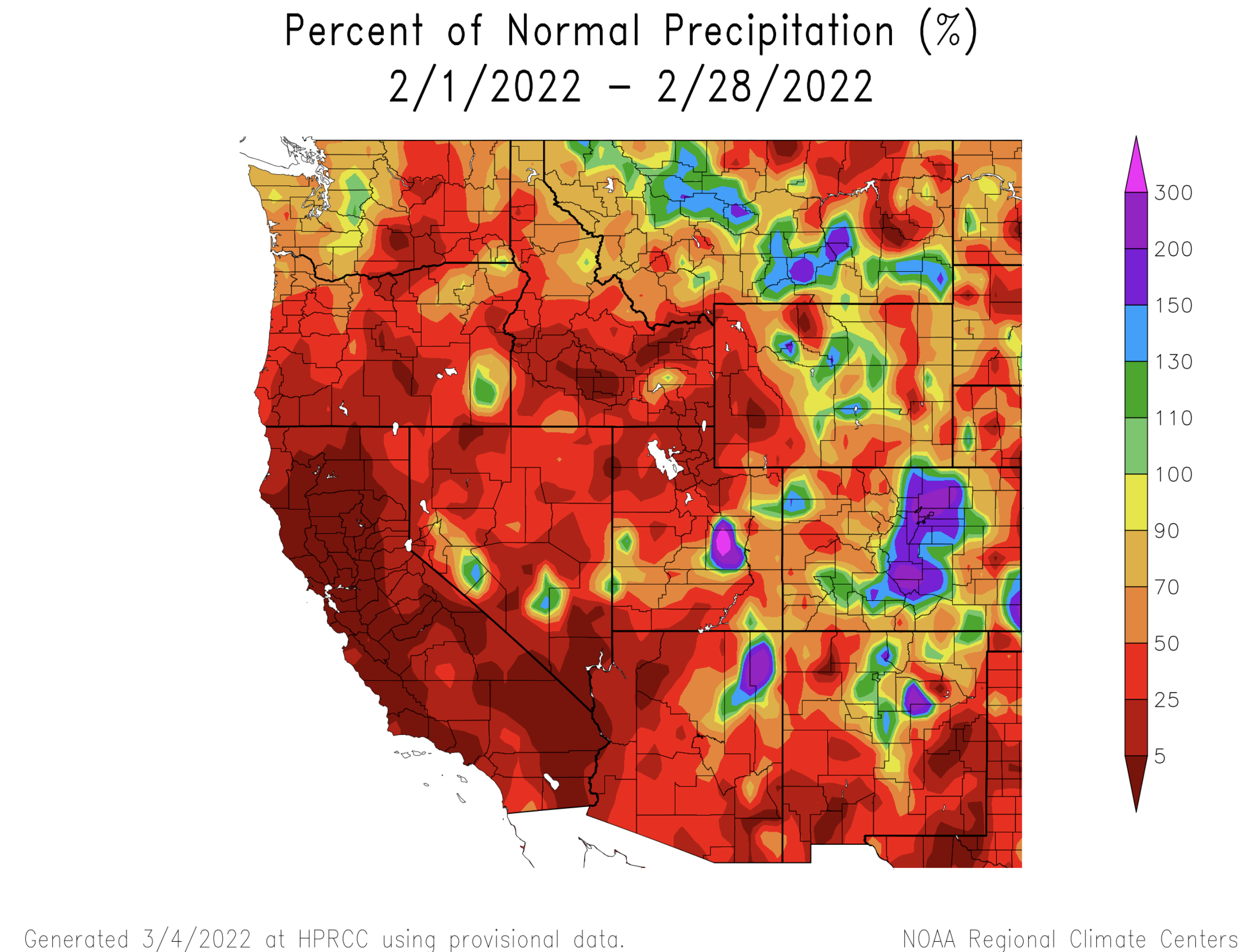
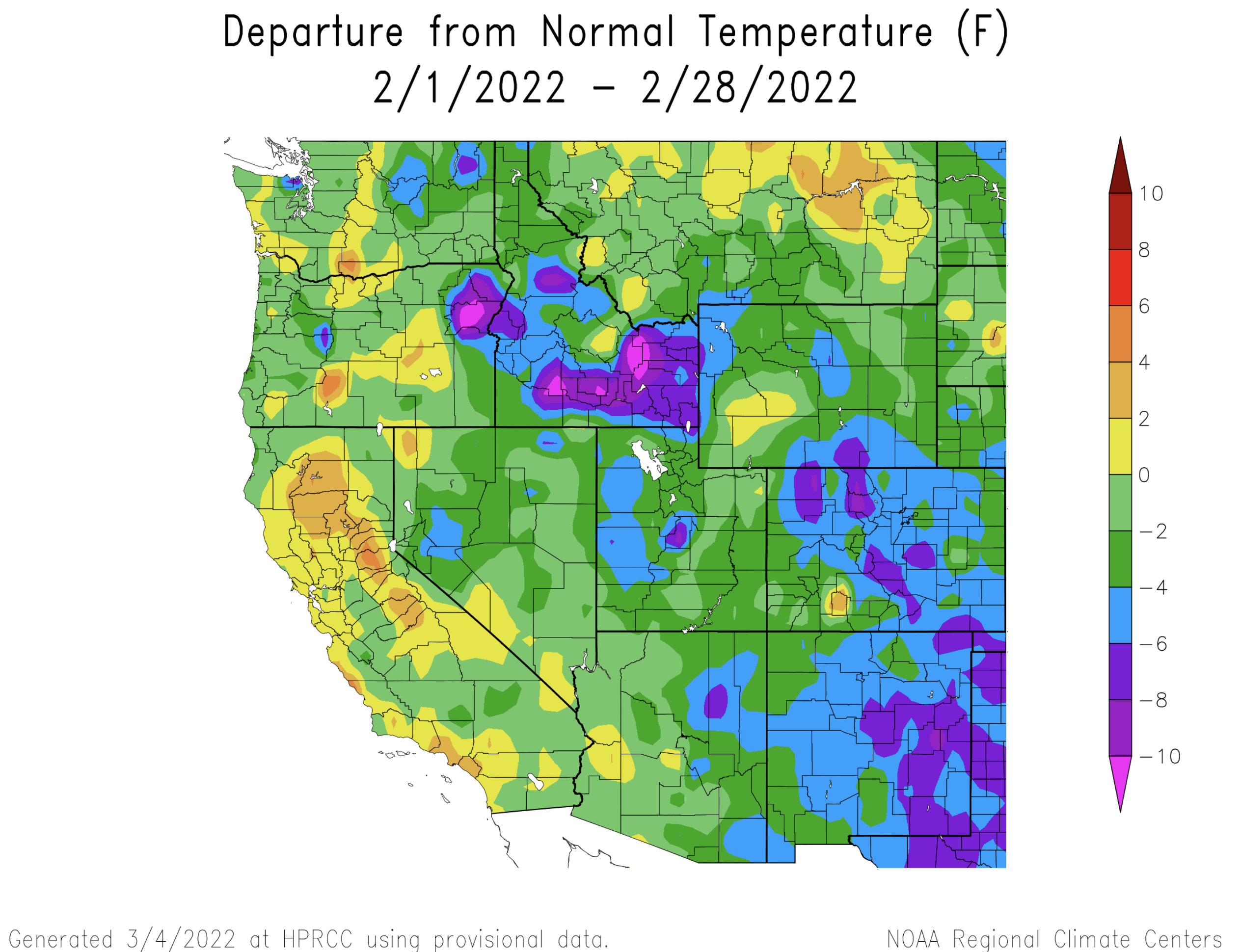
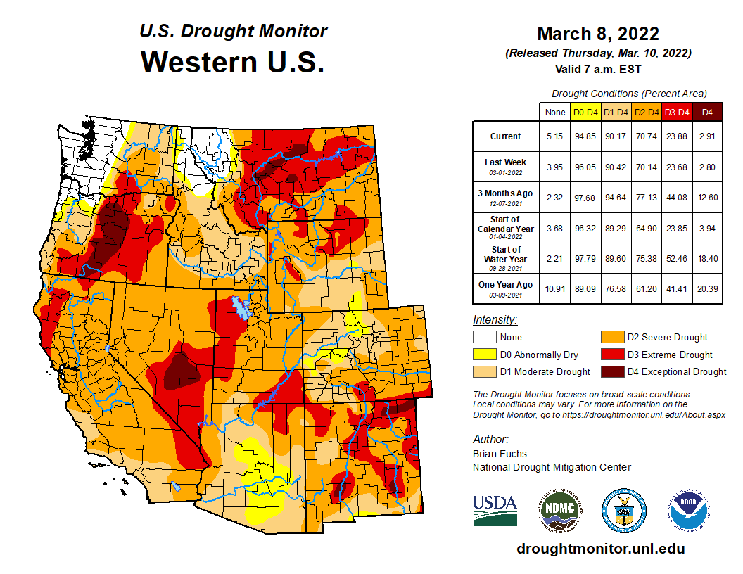
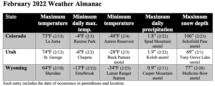
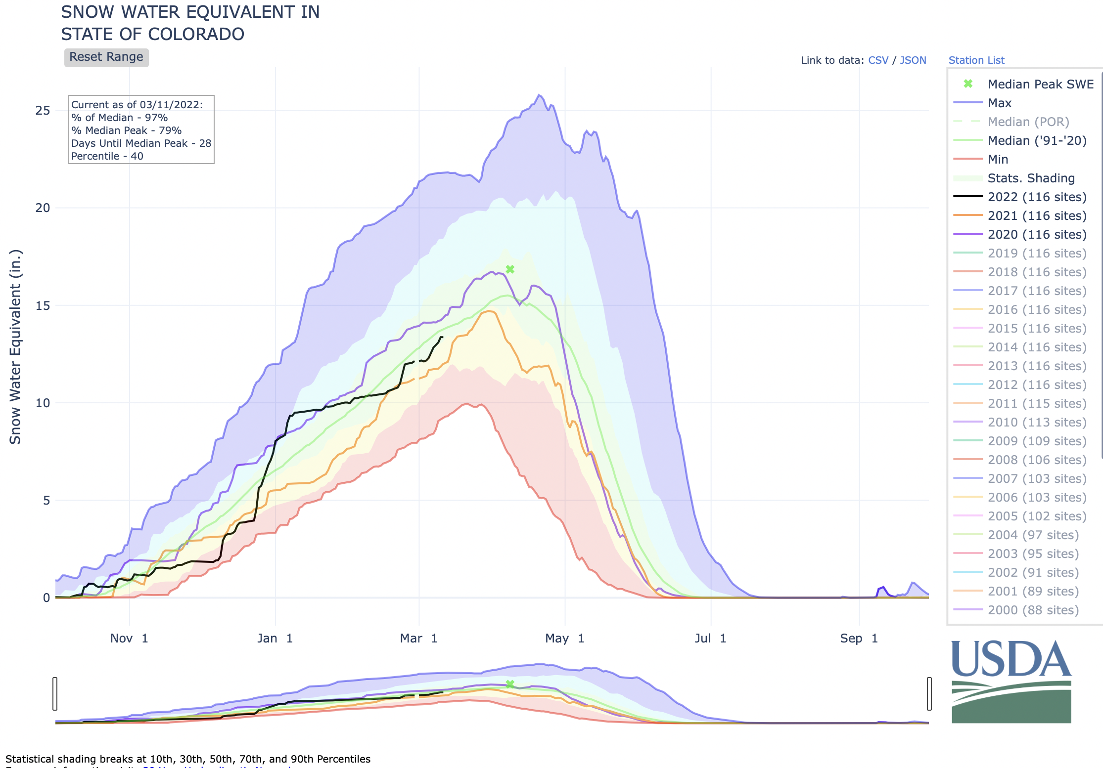
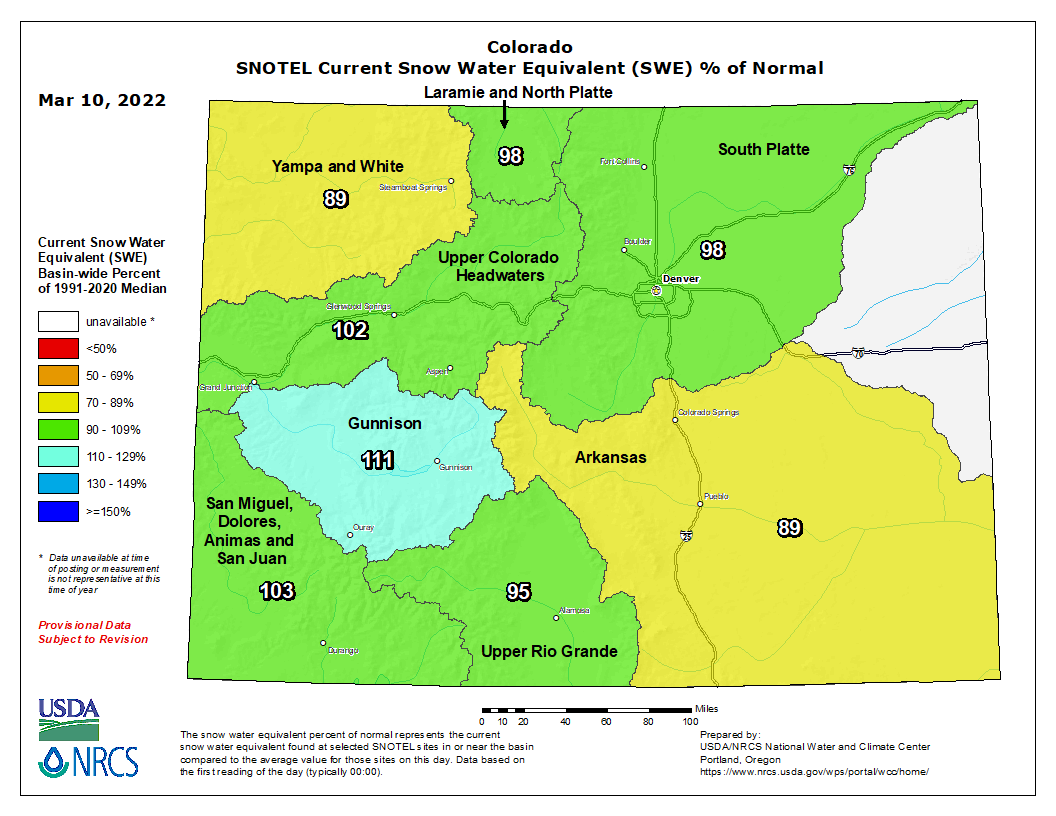
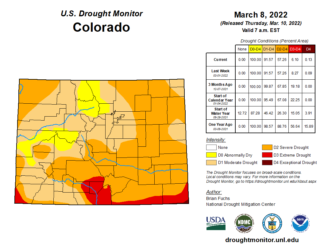
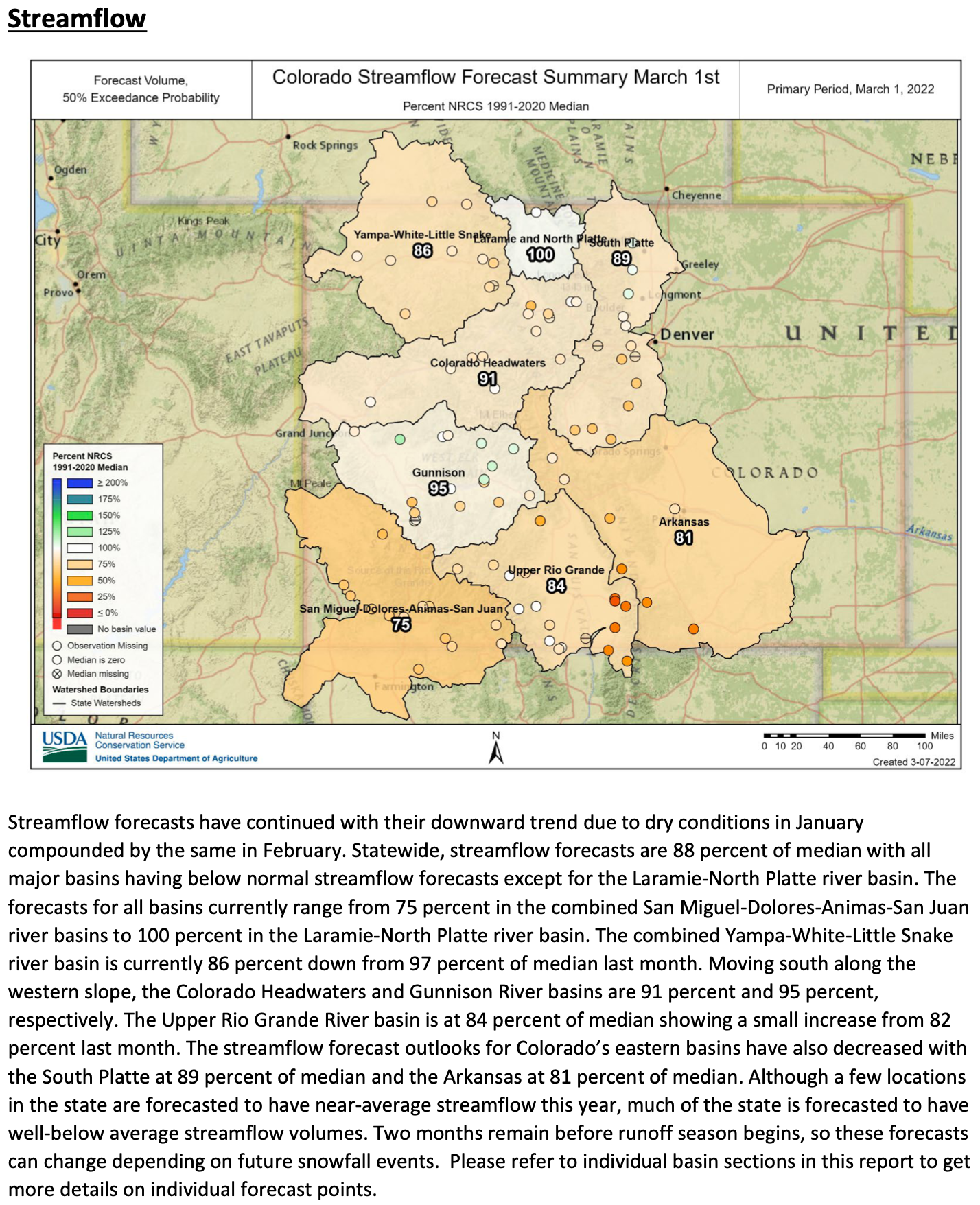


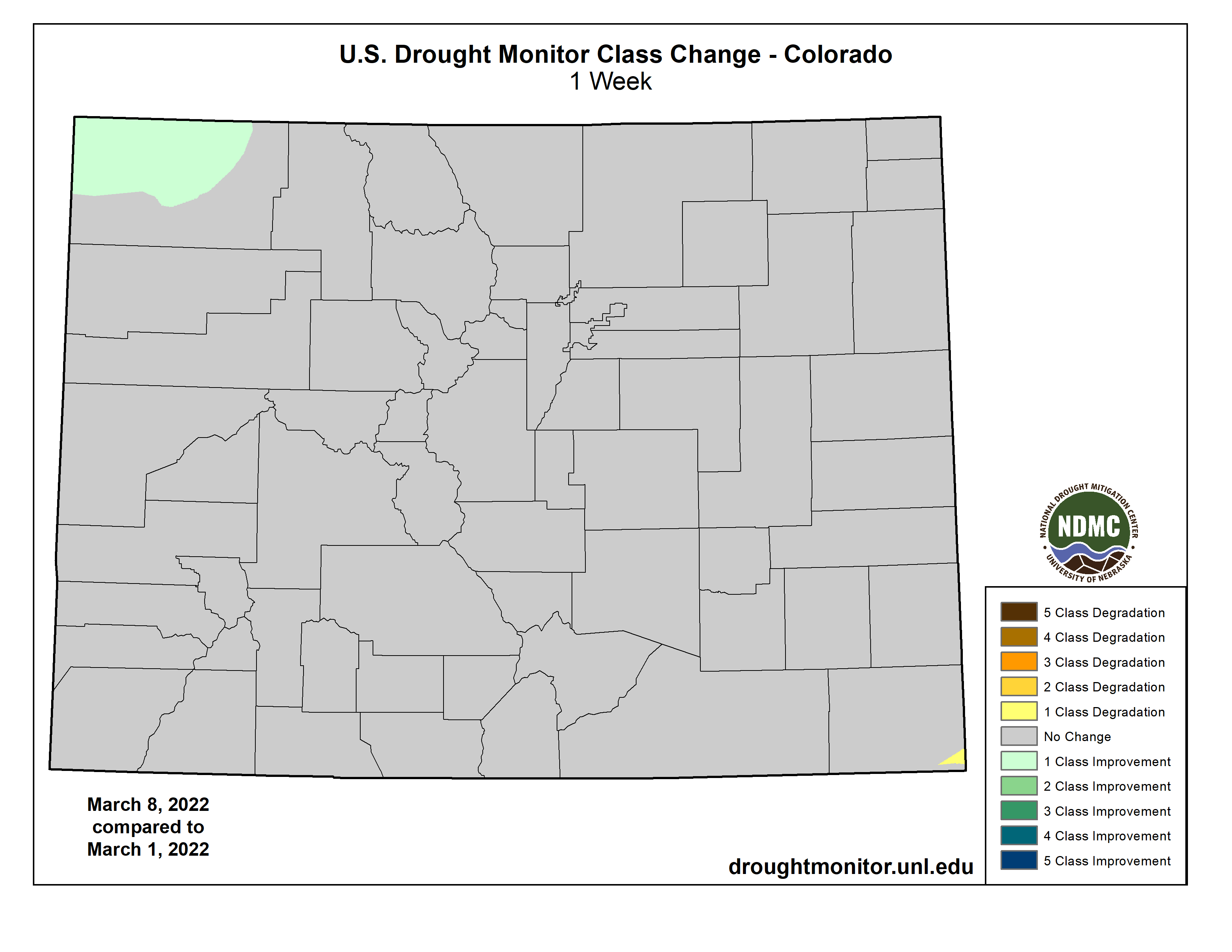
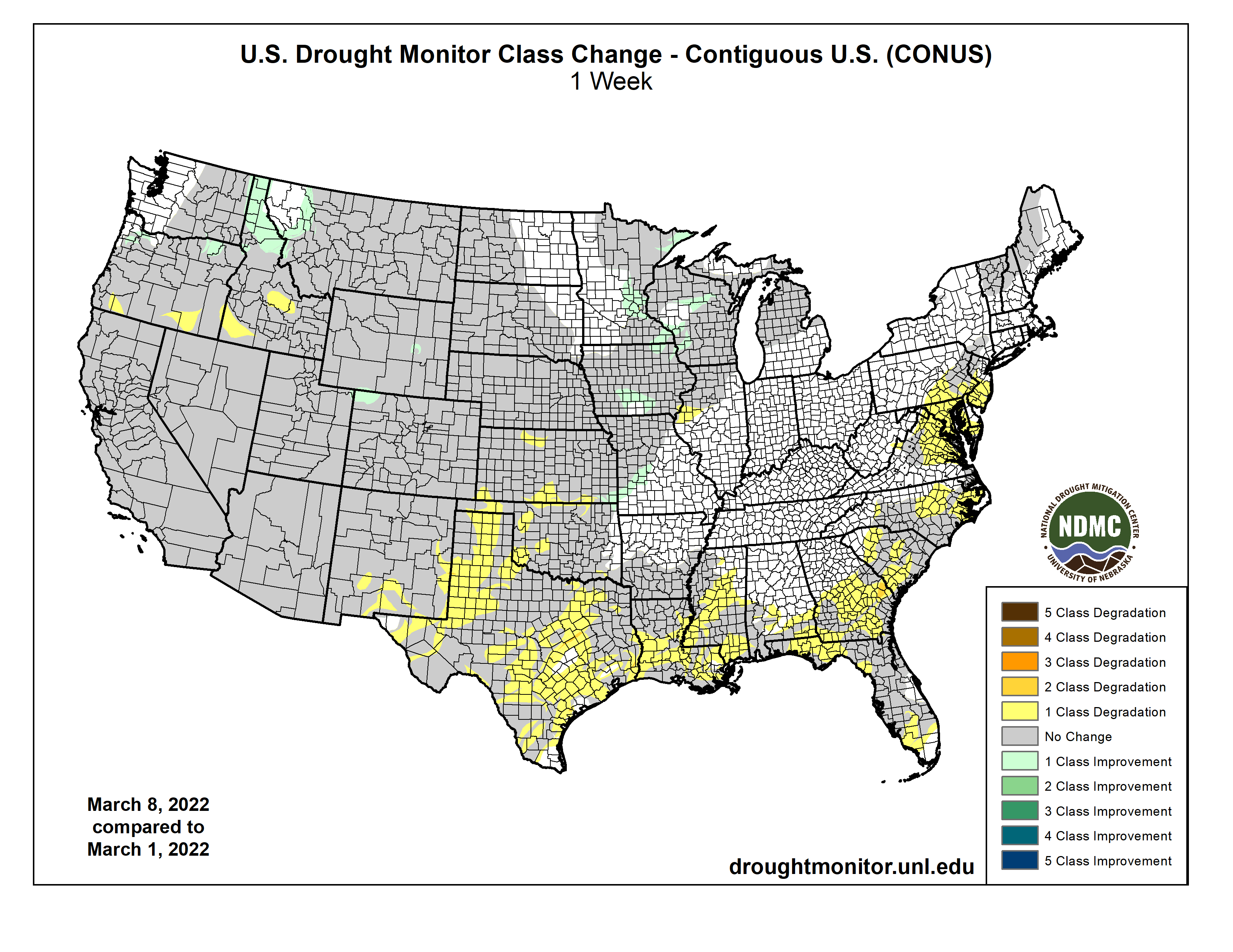
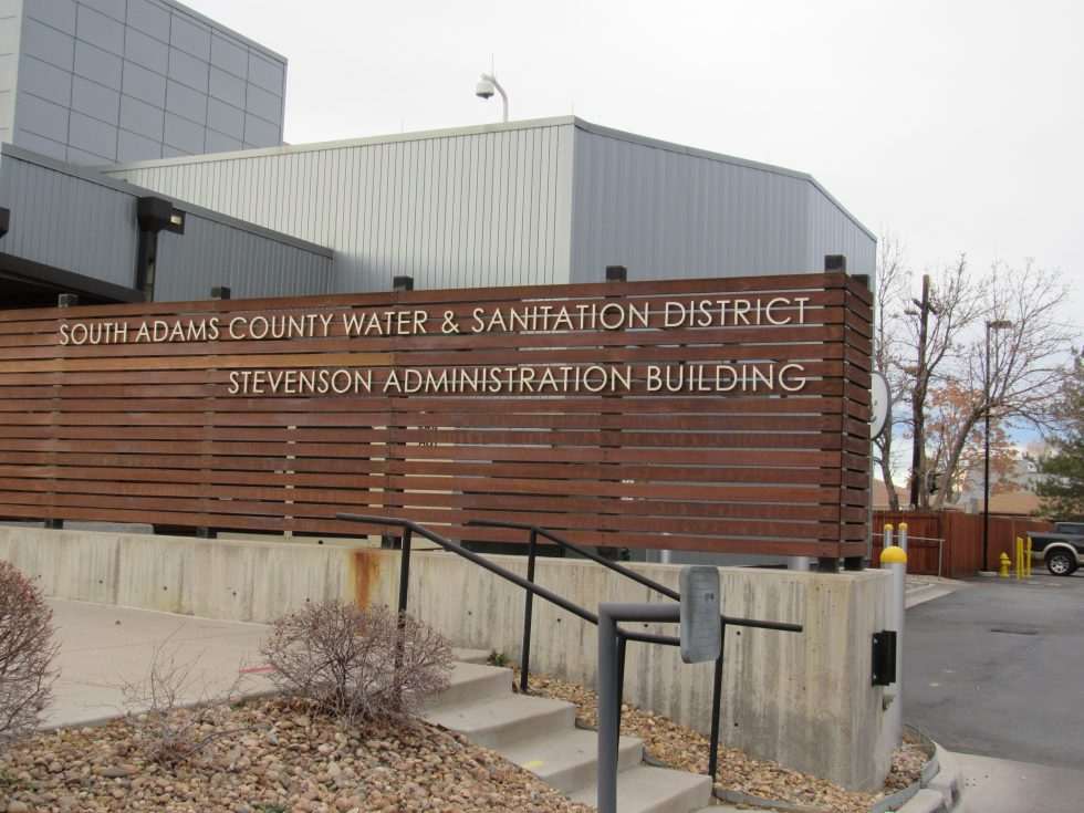
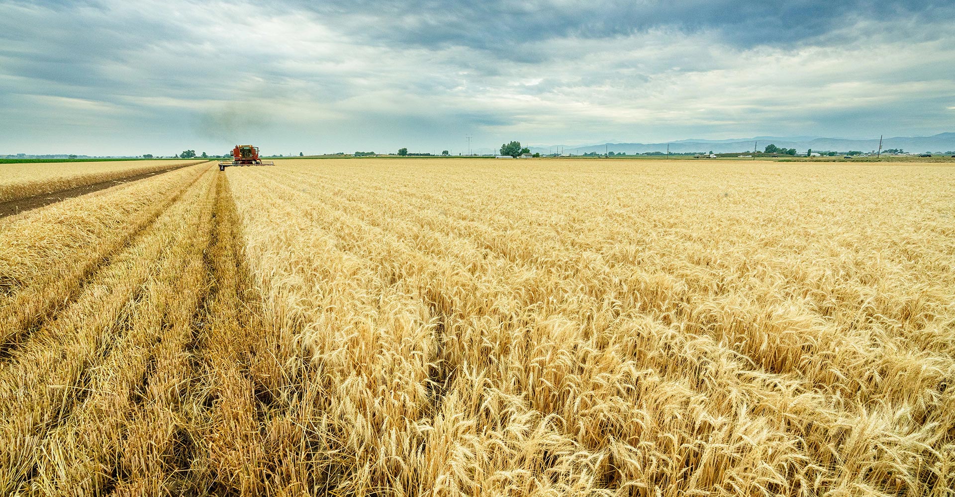
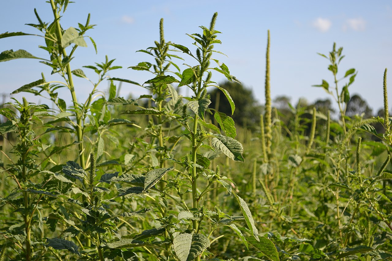
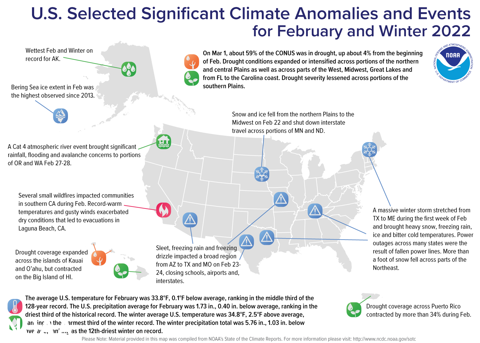
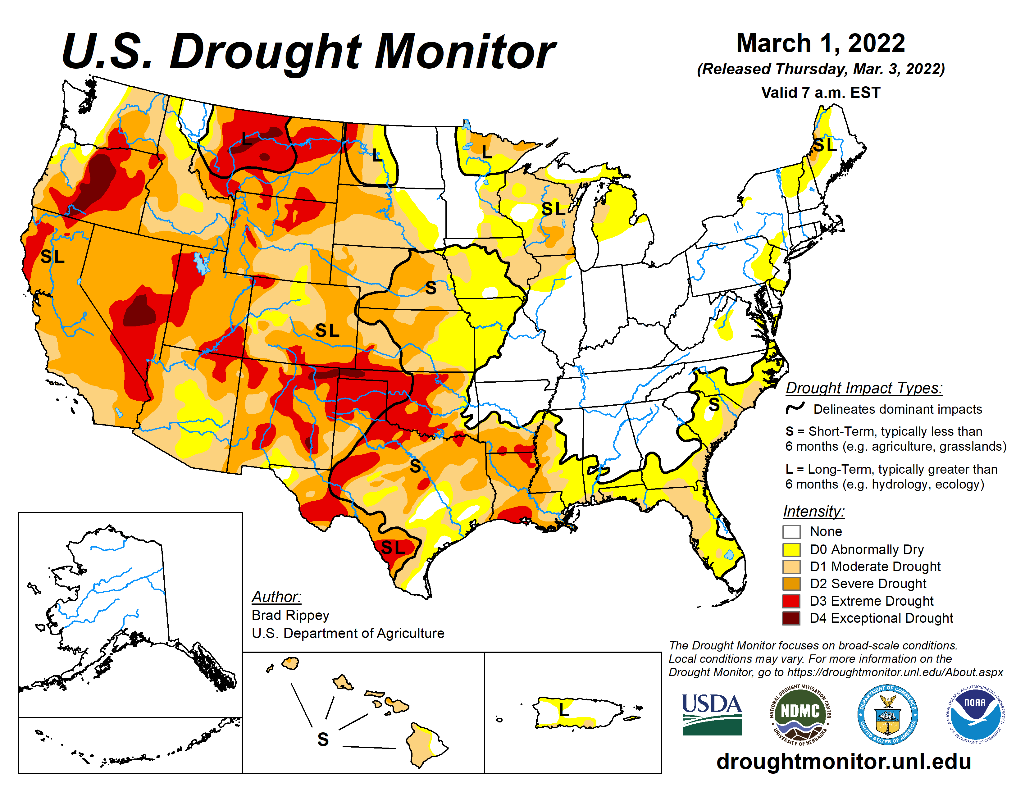
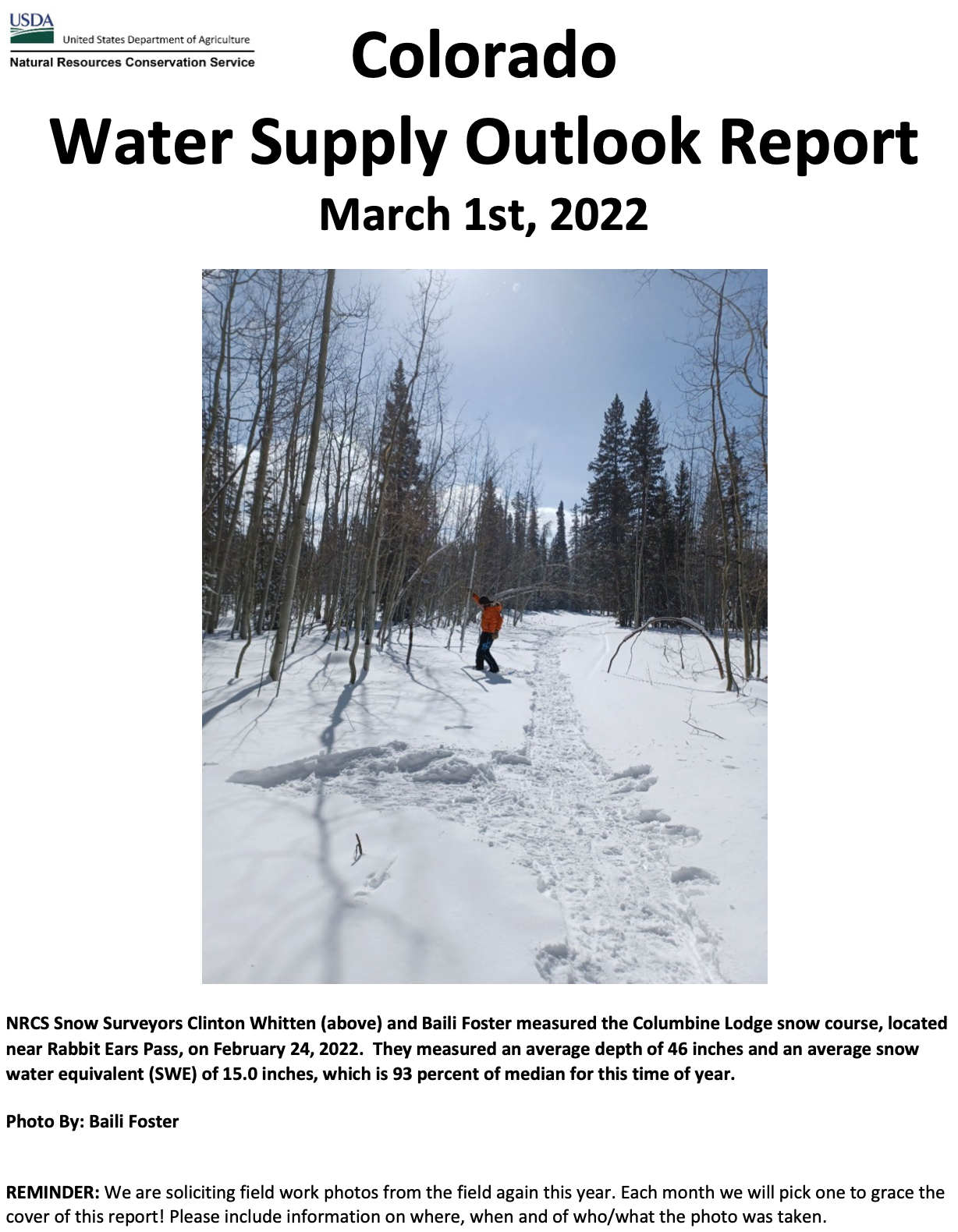
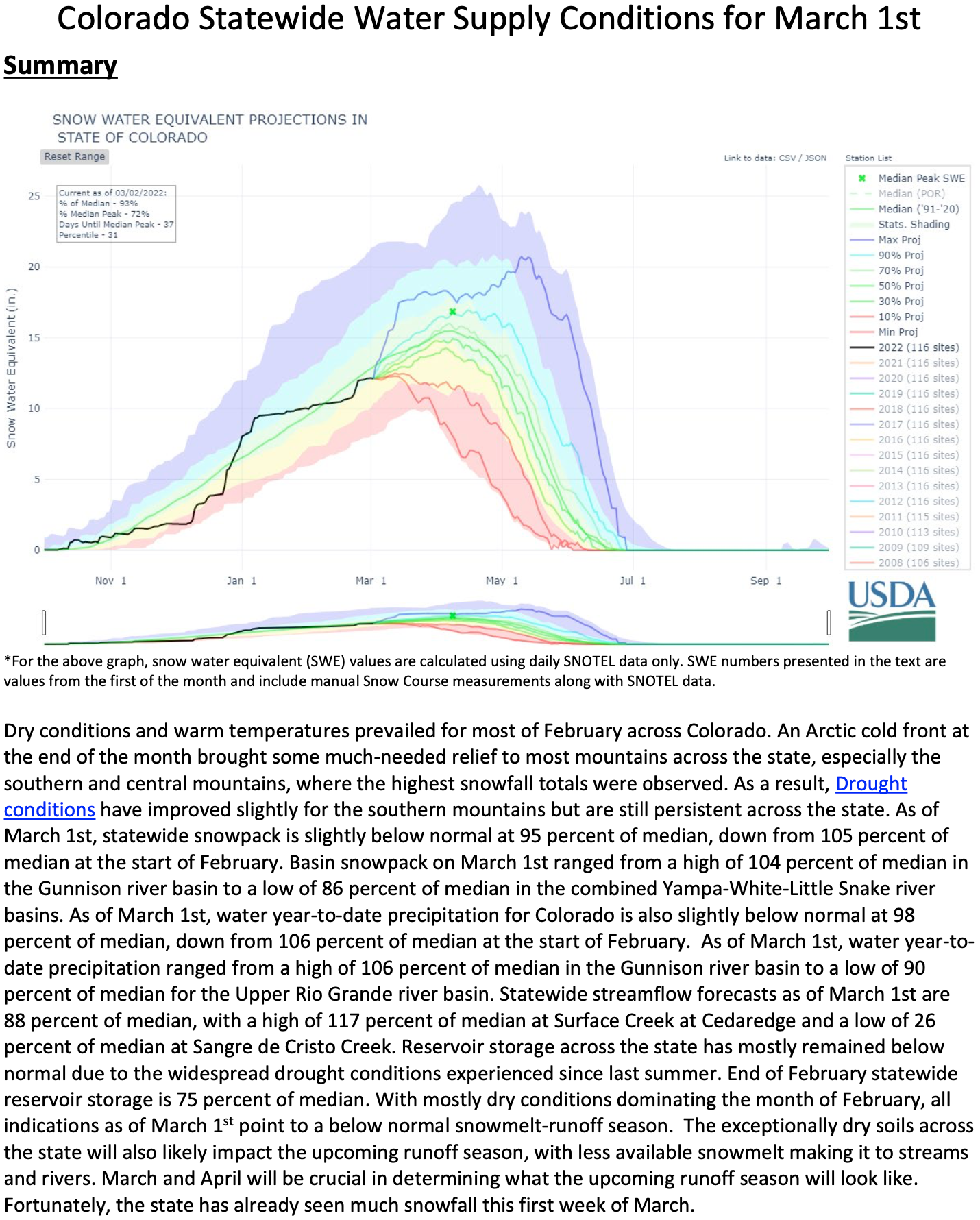
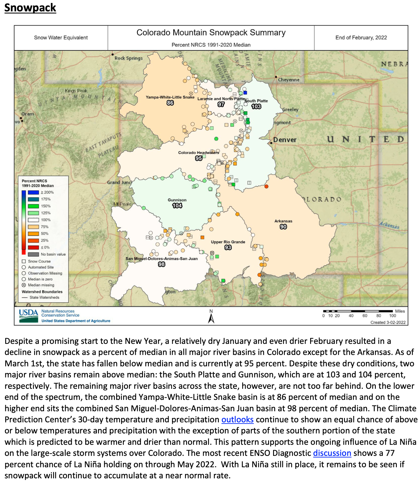
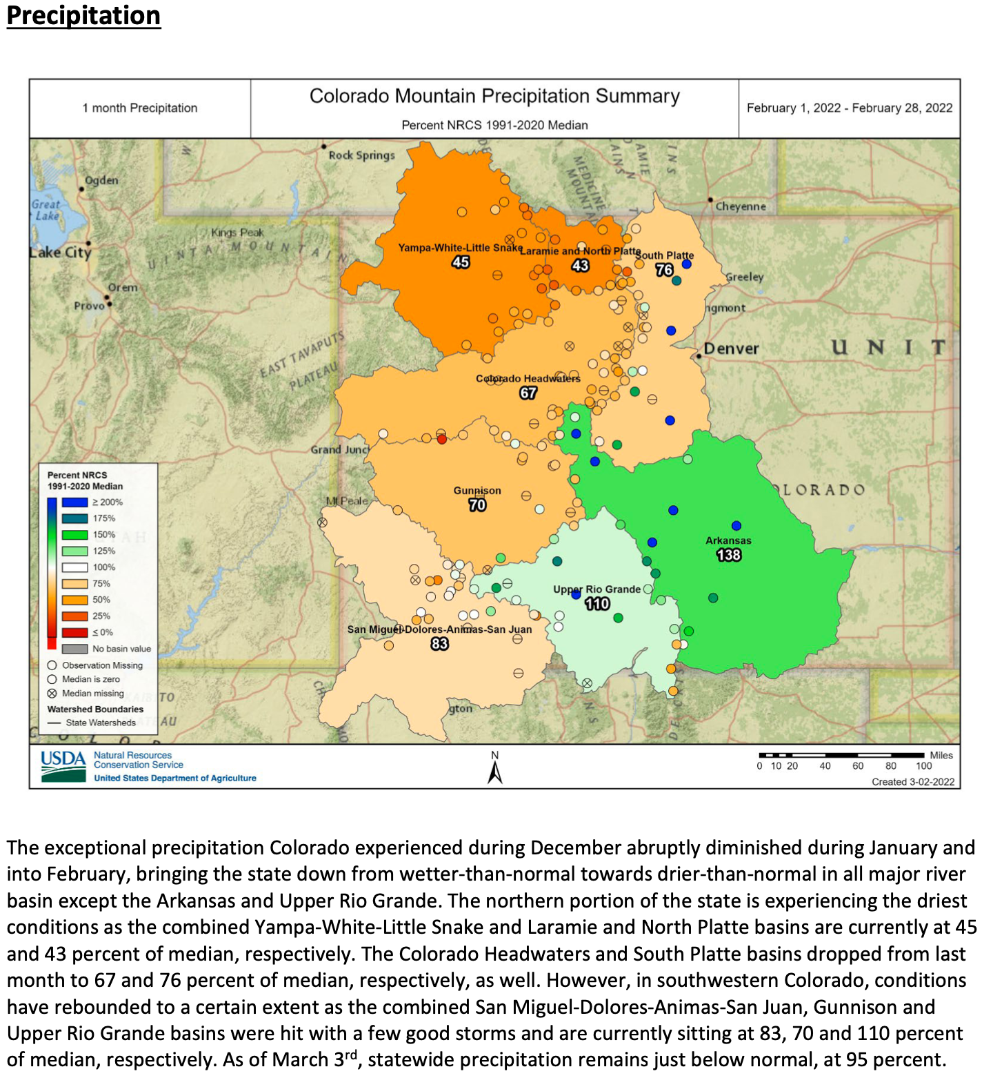
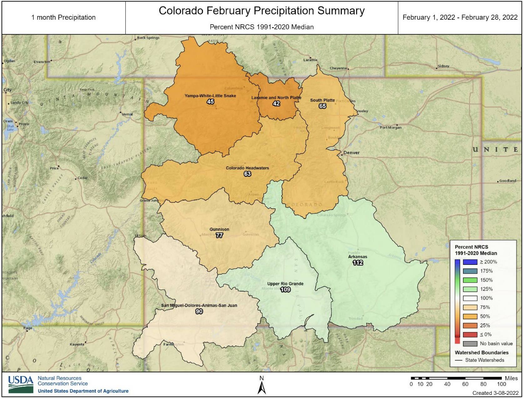
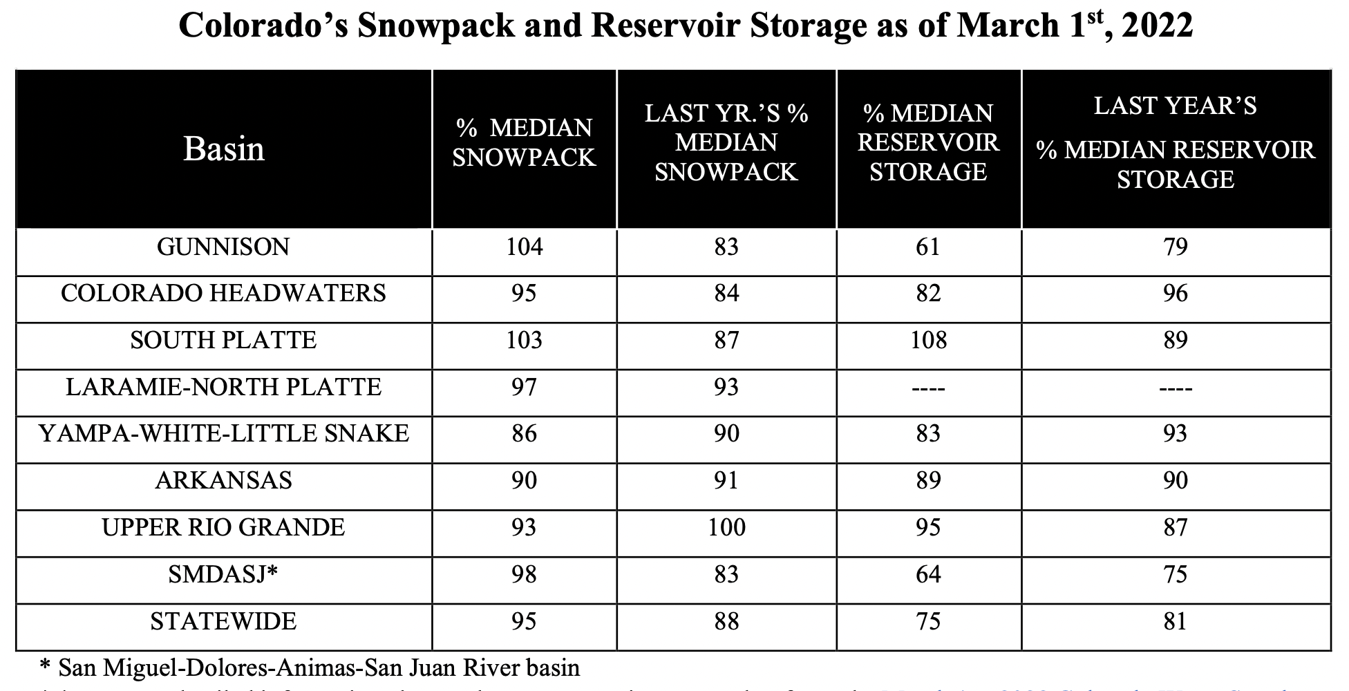
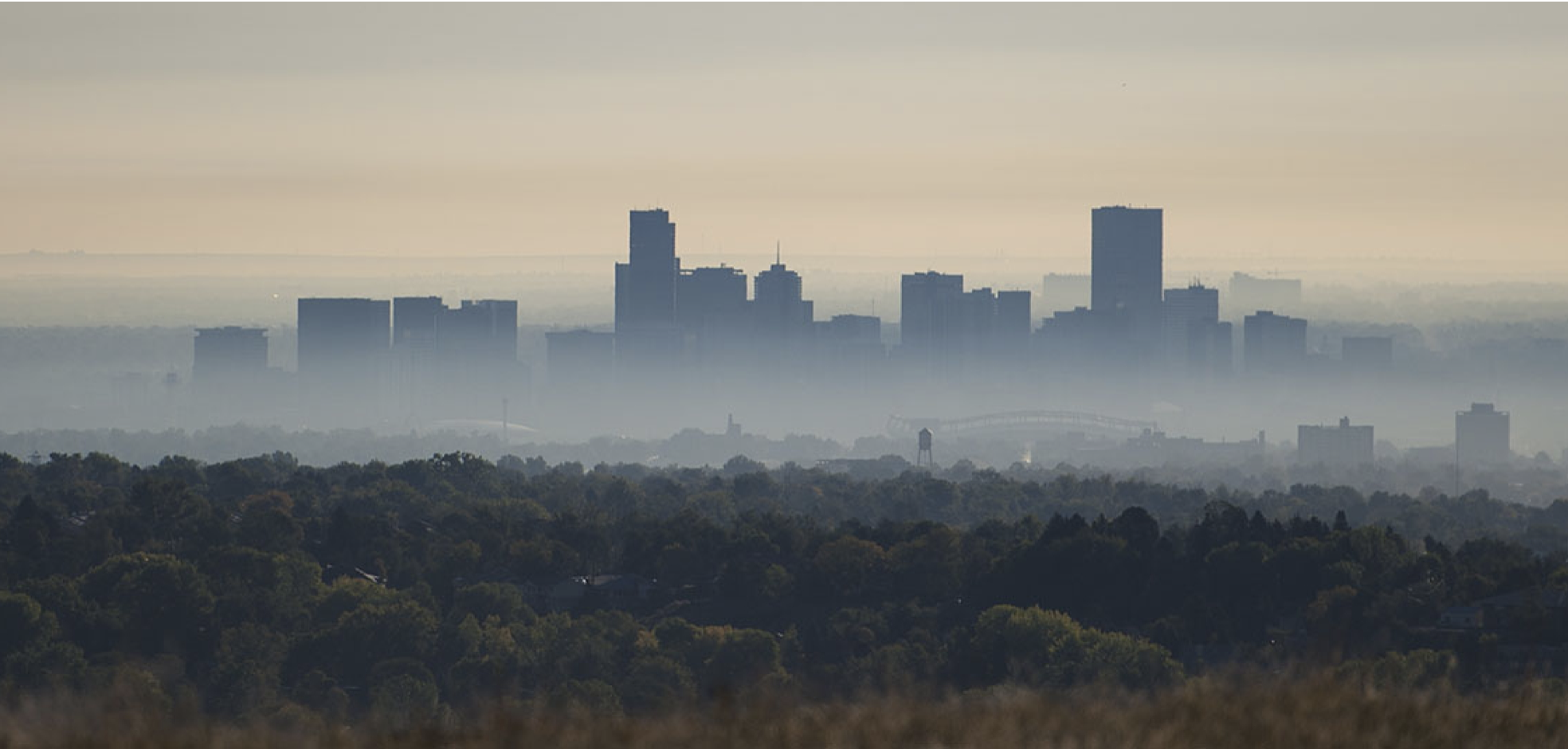

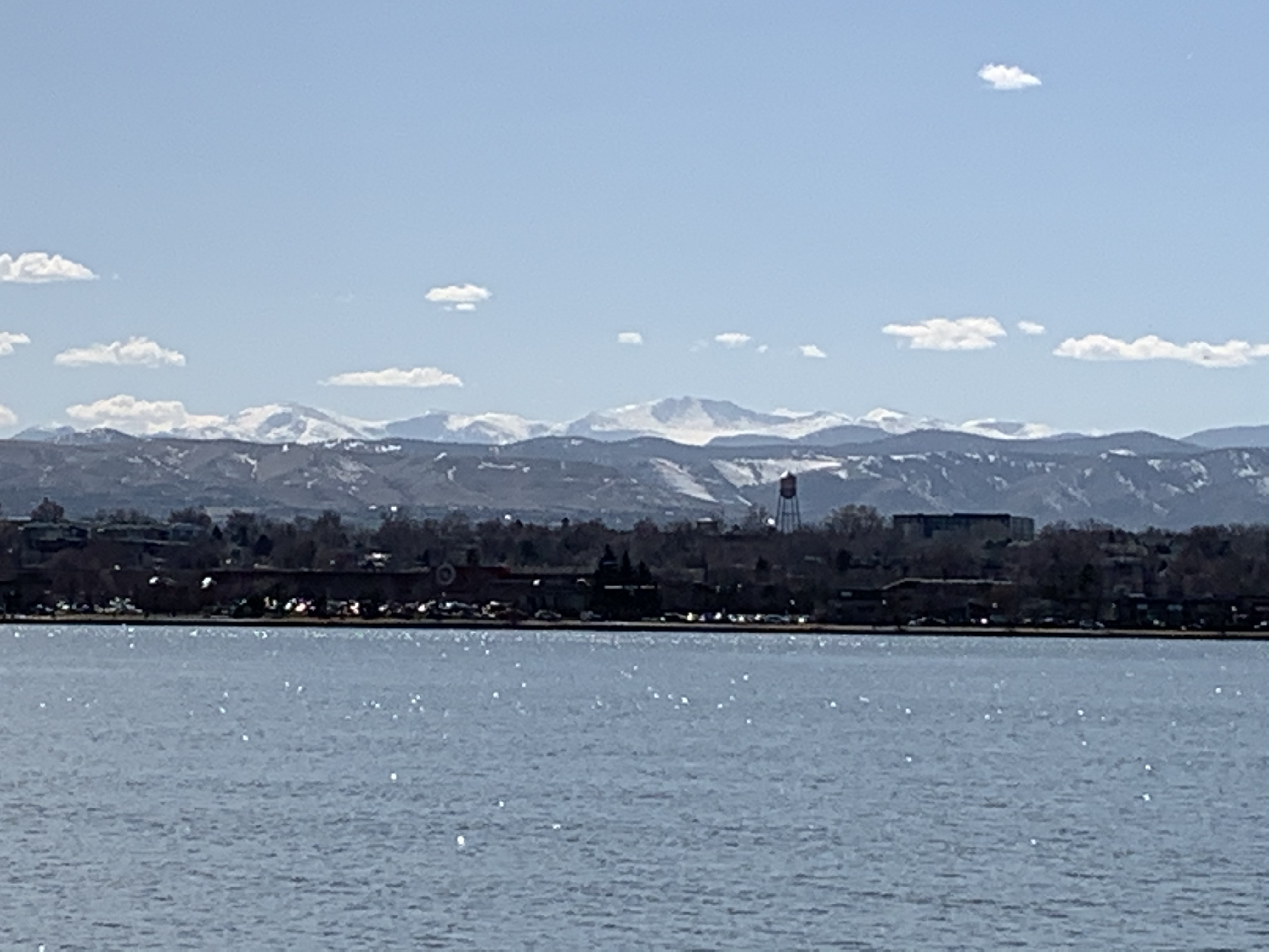
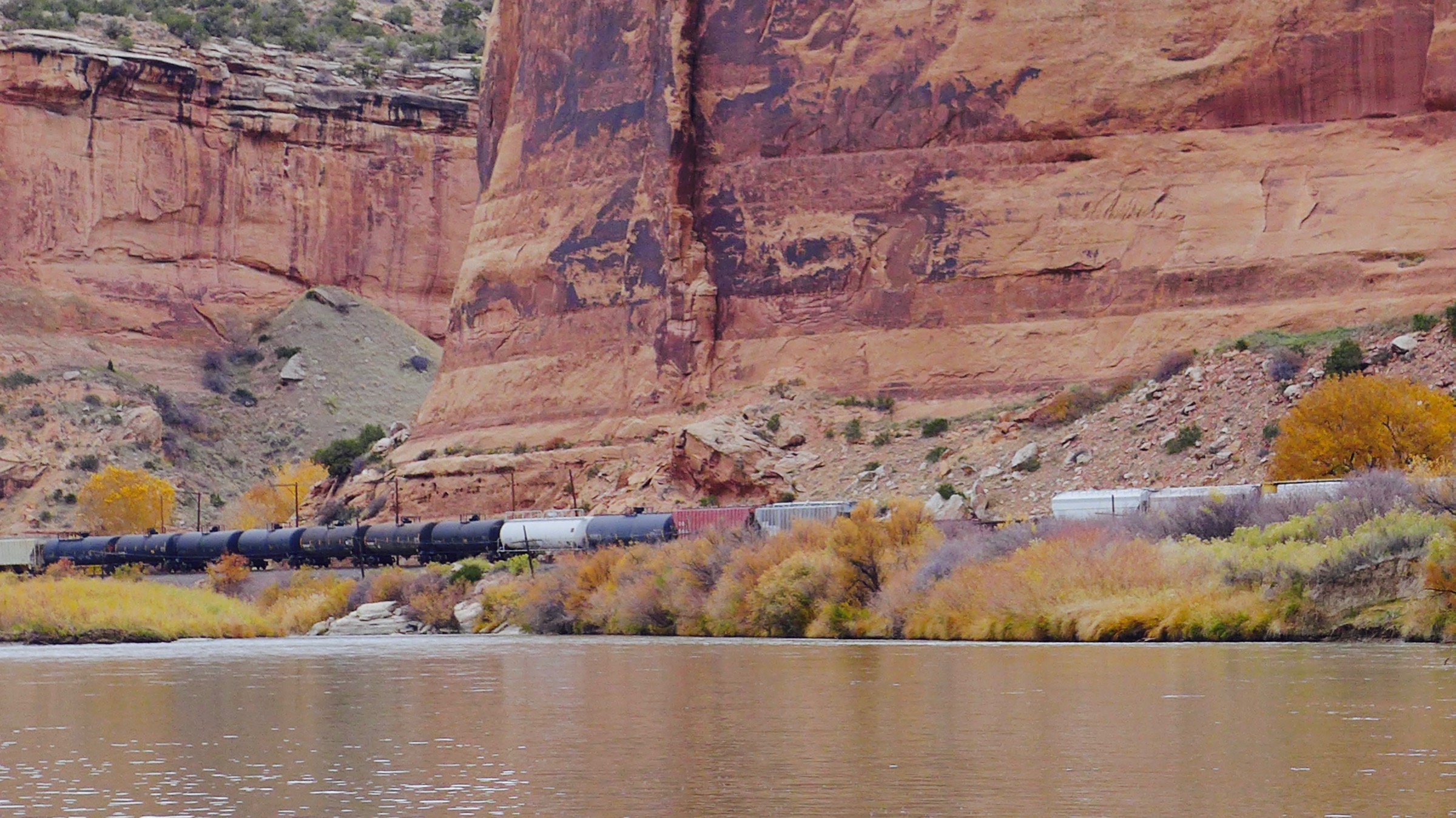


_basin_map")