
Click a thumbnail graphic to view a gallery of drought data from the US Drought Monitor website.

Click the link to go to the US Drought Monitor website. Here’s an excerpt:
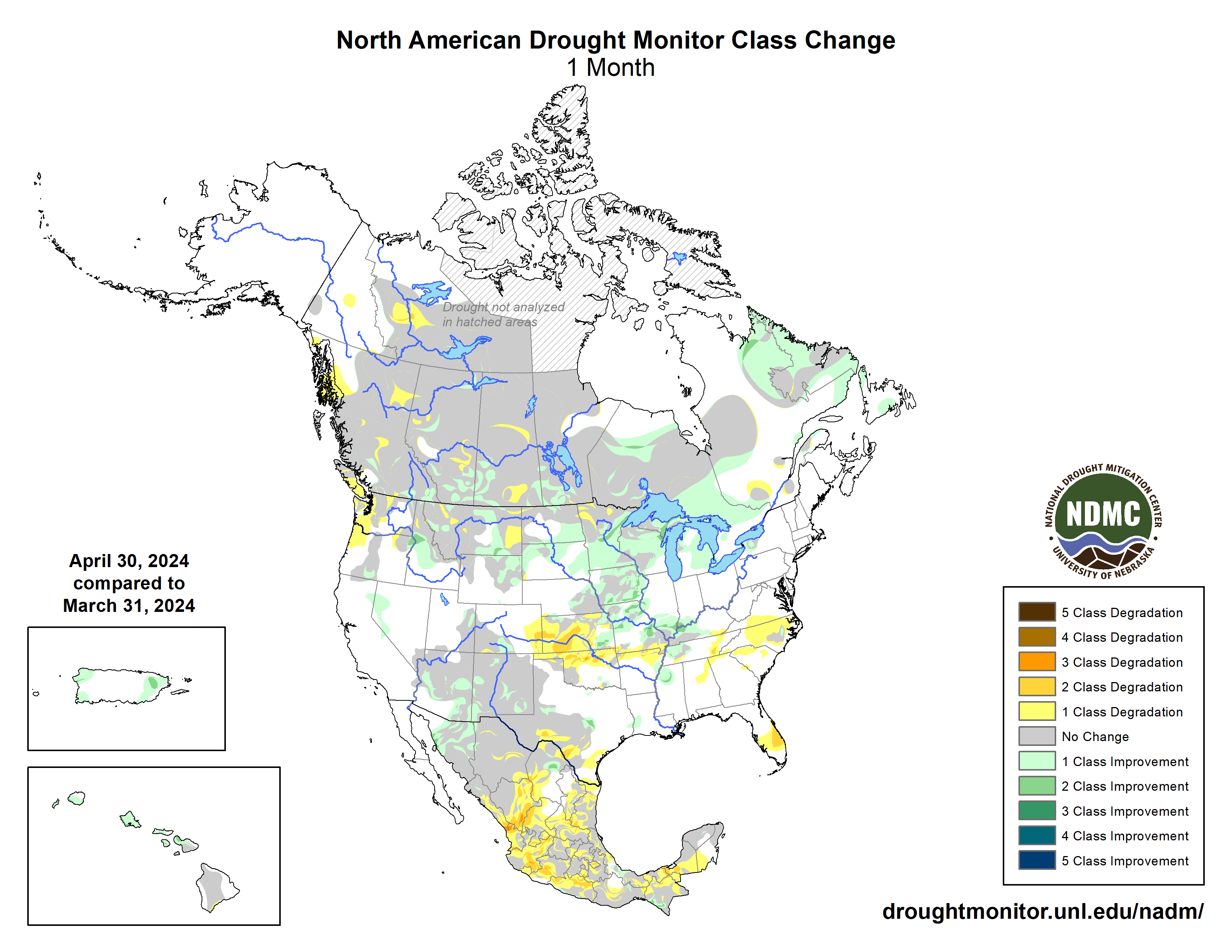
This Week’s Drought Summary
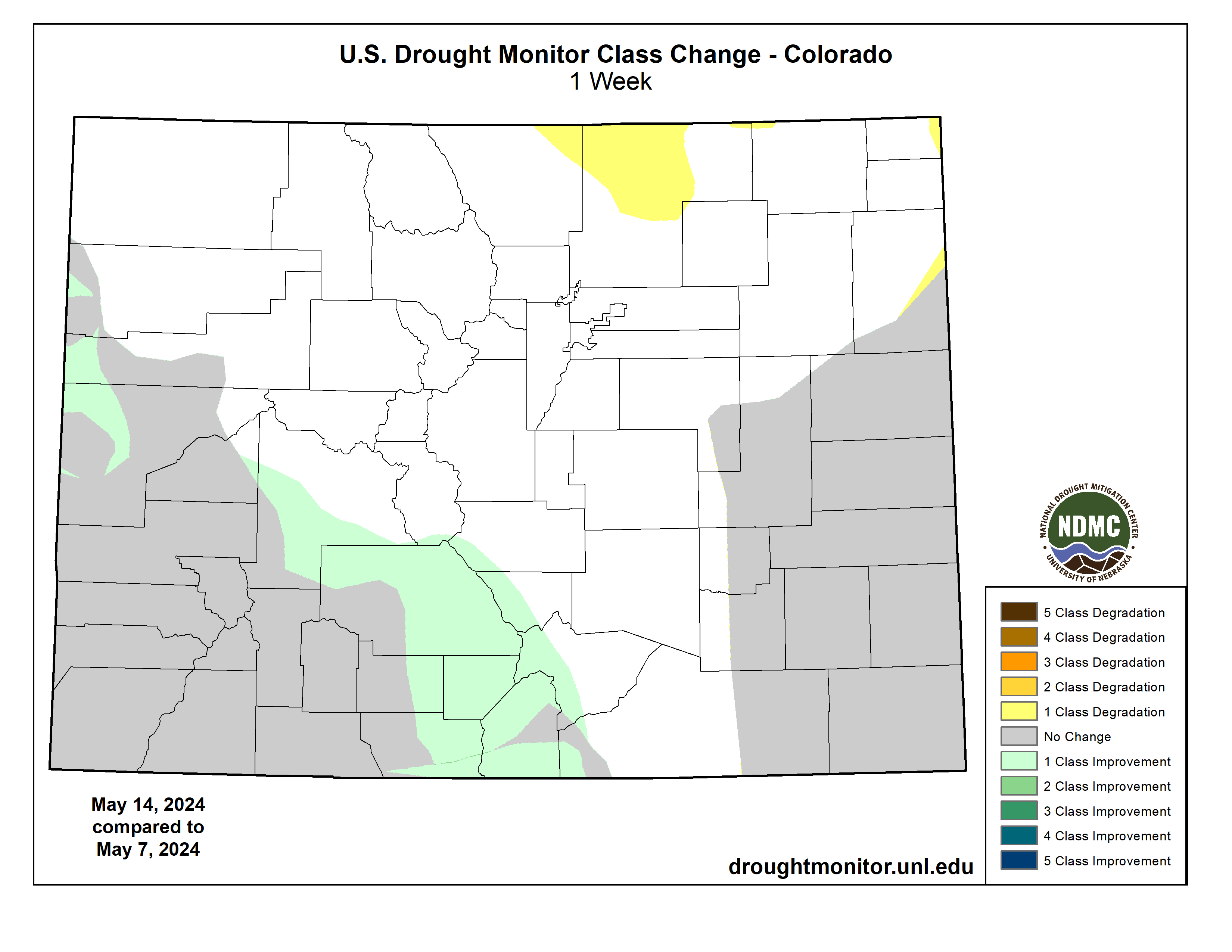
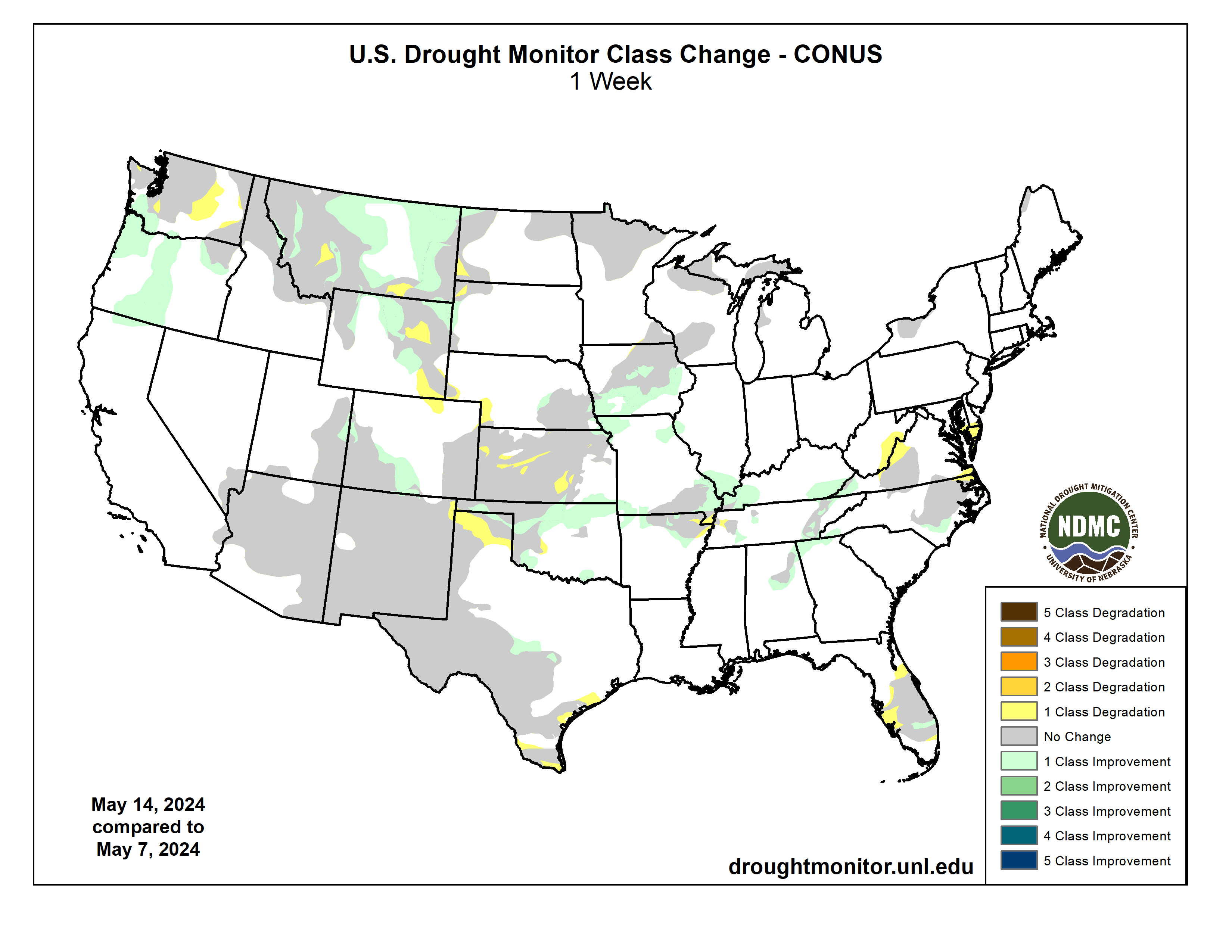
Heavy precipitation fell across the Rocky Mountains of Montana, Wyoming and Colorado, as well as a large part of the South and southern Midwest. This brought widespread improvements to much of the South and Midwest, with scattered or widespread improvements in the Great Plains and Midwest. Heavy precipitation falling over the Southeast brought improvements from central Alabama into the southern Appalachian Mountains, as well as the area surrounding the convergence of the Ohio, Mississippi, and Tennessee rivers. A small area of the Mid-Atlantic region missed out on much of the precipitation, leading to minor degradations. Very dry weather for the past few months led to increased fire danger in parts of the Florida Peninsula, and short-term moderate drought and abnormal dryness expanded in coverage. Texas saw isolated degradations in the panhandle and south – where record breaking temperatures converged with the lack of precipitation. The High Plains were a mixture of light to moderate precipitation, which greatly influenced where improvements or degradations were made. Kansas, Colorado and Wyoming saw improvements where measurable precipitation fell. Degradations occurred in western Kansas and eastern Wyoming, where trace amounts of precipitation fell. Montana saw heavy precipitation, which improved conditions across much of the state. Isolated storms in western Oregon and Washington brought widespread improvements in Oregon, which continued into southwestern Washington. Central Washington, meanwhile, missed out on the precipitation and saw further expansion of abnormal dryness…
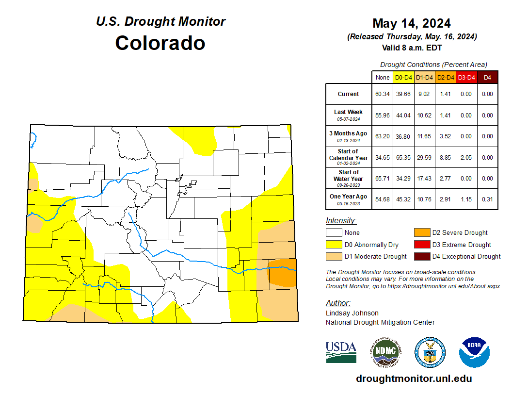
High Plains
The High Plains was a mixed bag of light to moderate precipitation, as well as improvements and degradations. Wyoming and Colorado saw improvements and degradations closely aligning with areas of moderate and light precipitation respectively. Northern and central Wyoming saw improvements, which were a continuation of improvements made in Montana and South Dakota. However, degradations occurred in areas that received trace amounts of precipitation along the eastern and southeastern part of these states into northern Colorado. Northeastern Colorado also saw a slight introduction of abnormally dry (D0) conditions as overflow from adjoining area of western Nebraska, where precipitation was low. Slight improvements occurred in south and northeast areas of Kansas that received precipitation. Elsewhere, conditions in central and western Kansas continued to degrade as streamflows, soil moisture, and groundwater continued to deteriorate. Southeast Nebraska saw slight improvements from continuous moisture over the past few weeks…
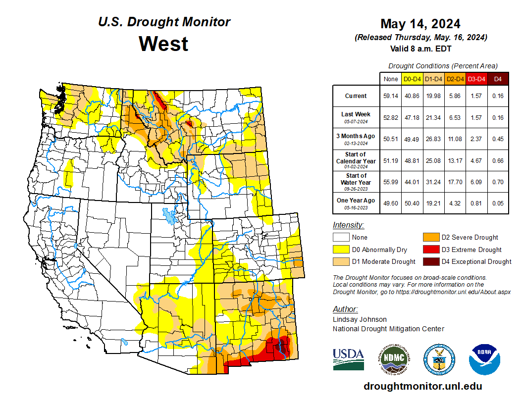
West
Temperatures across the northern and Pacific coast of the West saw temperatures of 2 to 6 degrees above normal. Areas in northern California, northwest Oregon, south and central Washington and northeastern Montana experienced temperatures 6 to 8 degrees above normal. Little to no measurable precipitation fell over much of the West, except for Montana where 1 to 3 inches of precipitation fell. Conditions improved through most of central and western Montana with slivers of improvement in the parts where the short-term dryness from the weeks past have shown improvement. There were some isolated areas in western and southern Montana that saw degradations. Oregon saw widespread improvements in part due to the isolated precipitation and improved streamflow and soil moisture. These conditions were also seen in southern Washington where improvements were made. Central Washington, however, missed out on any meaningful precipitation and saw temperatures of 4 to 8 degrees above normal, leading to abnormal dryness (D0) expansion…
South
The South saw a mixture of improvements in the north and degradation in the western and southern parts of the region. Western Texas, central Arkansas and northern Mississippi saw trace amounts of precipitation, while central and eastern Texas, Louisiana, and central and southern Mississippi saw between 2 to 5 inches of precipitation. Precipitation helped alleviate conditions in northern, western and southern Oklahoma. Following the precipitation, further improvements occurred across northern Arkansas and western and eastern Tennessee.
The Texas panhandle and southern parts of Texas saw expansion of existing abnormal dryness – and a small sliver of moderate drought (D1) in far south Texas – with a lack of measurable precipitation and above-normal temperatures. Southern Texas saw temperatures of 6 to 8 degrees above normal with Brownsville (124°F), Harlingen (125°F), and McAllen (122°F) breaking May temperature records of 115°F (5/4/1999), 121°F (5/26/1973), and 119°F (5/13/1995) respectively. A small area around the Missouri Bootheel also saw moderate drought (D1) expansion…
Looking Ahead
Over the next five days (May 16-21), heavy precipitation of2 to 5 inches is expected to continue to fall in the far South from central Texas to western Georgia, with 1 to 2 inches of rain expected in surrounding areas into the southern Midwest and Mid-Atlantic coast. The rest of the central and eastern United States will see some light precipitation. Much of the West will miss out on this precipitation.
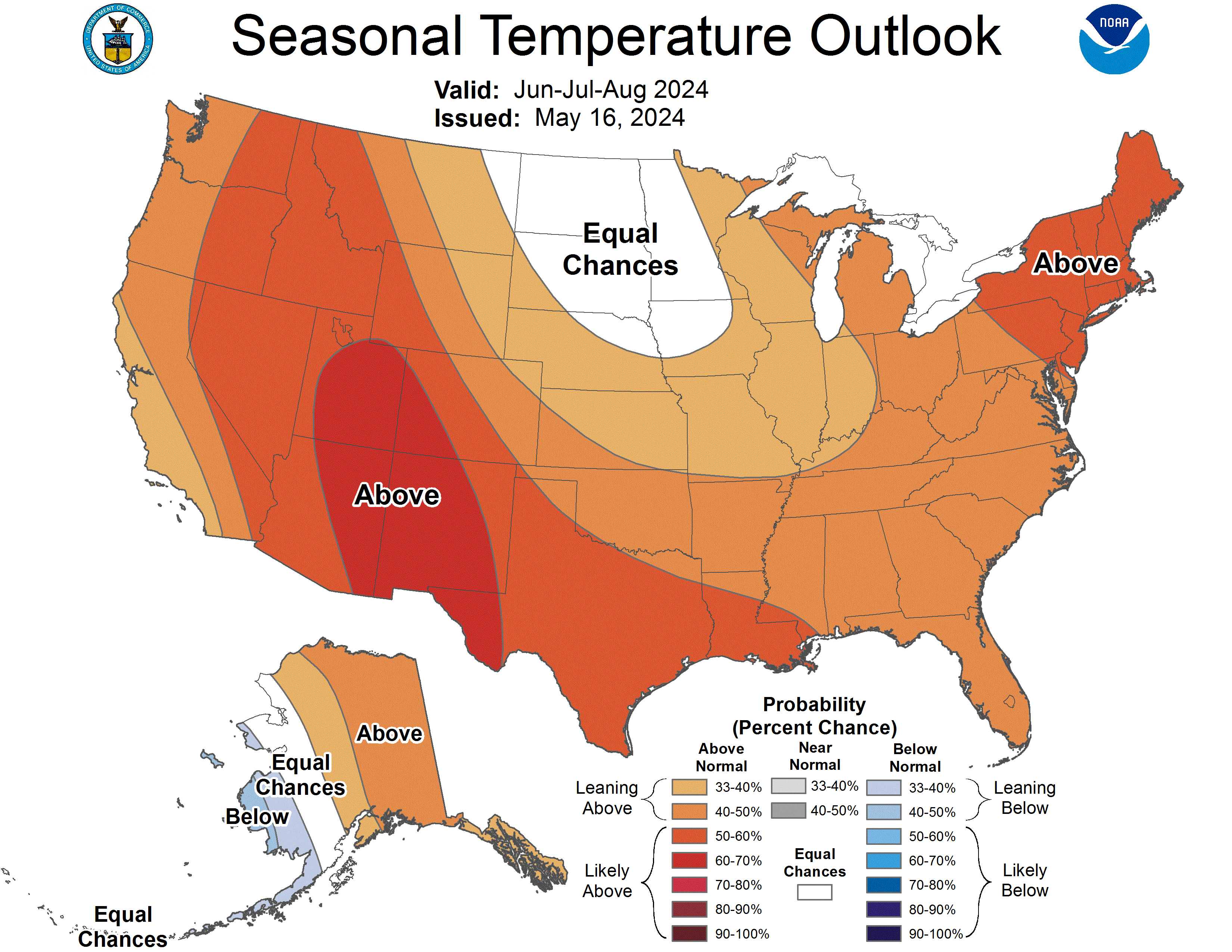
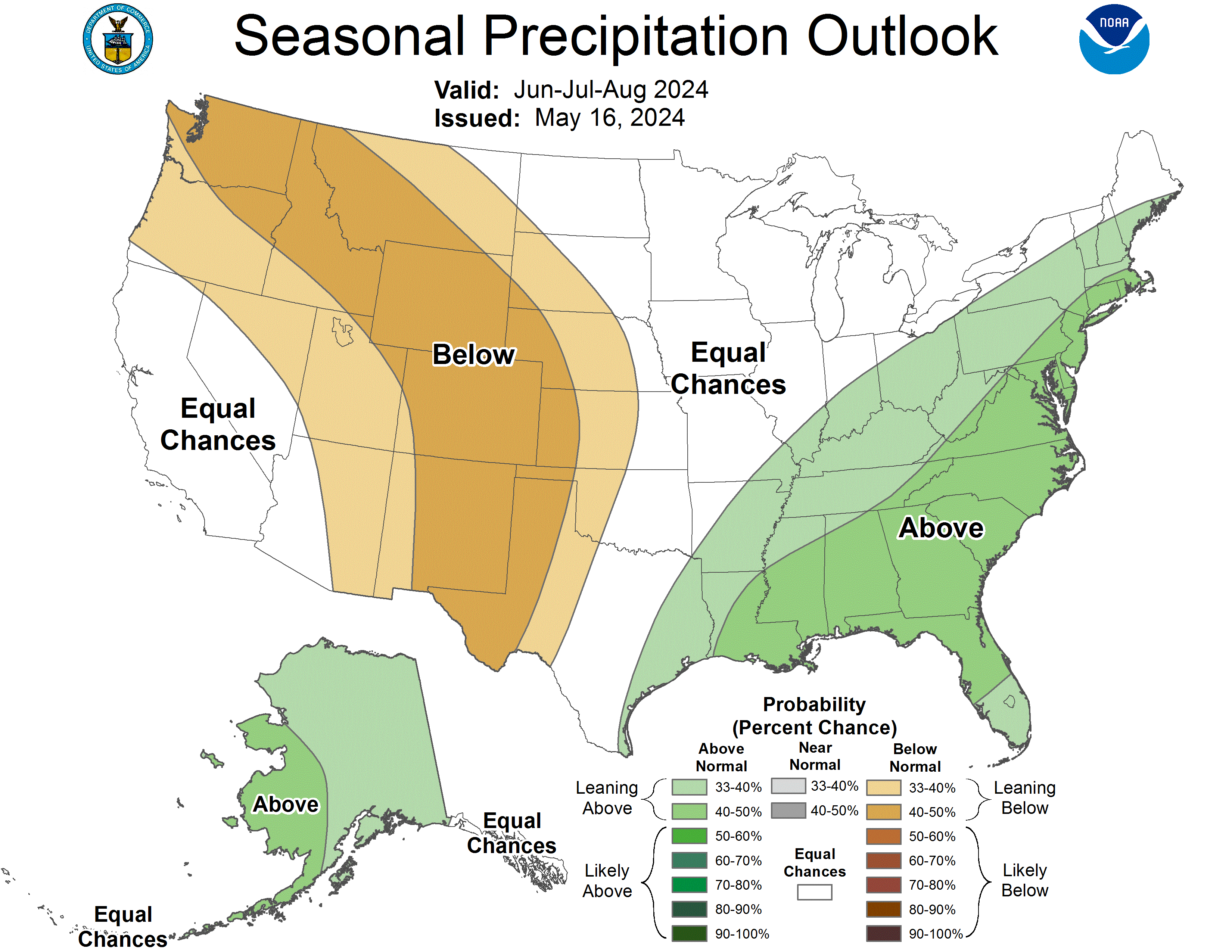
The National Weather Service Climate Prediction Center’s 6-10 day outlook heavily favors above-normal temperatures from New Mexico to Wisconsin, Maine, and down into Florida, with the greatest possibility being in southern Texas. The Southwest and High Plains are expected to be near normal temperature and everything to the west is likely going to be cooler than normal. Hawaii and northern Alaska are likely going to be warmer than normal, whereas parts central and western Alaska are leaning towards below-normal temperatures. For precipitation, much of the country is leaning towards above-normal precipitation. New Mexico and central and southern Texas are leaning toward below-normal precipitation, with the western and eastern coasts likely to be around normal. The Big Island of Hawaii is likely to see above-normal precipitation, along with central and northern Alaska. Southern Alaska is leaning toward below-normal precipitation.

At the end of April, 38.82% of Canada was in #drought (D1-D4), 14.32% of the US, and 68.06% of Mexico was in drought.
This story was originally published by Grist. Sign up for Grist’s Weekly newsletter here.
May 15, 2024
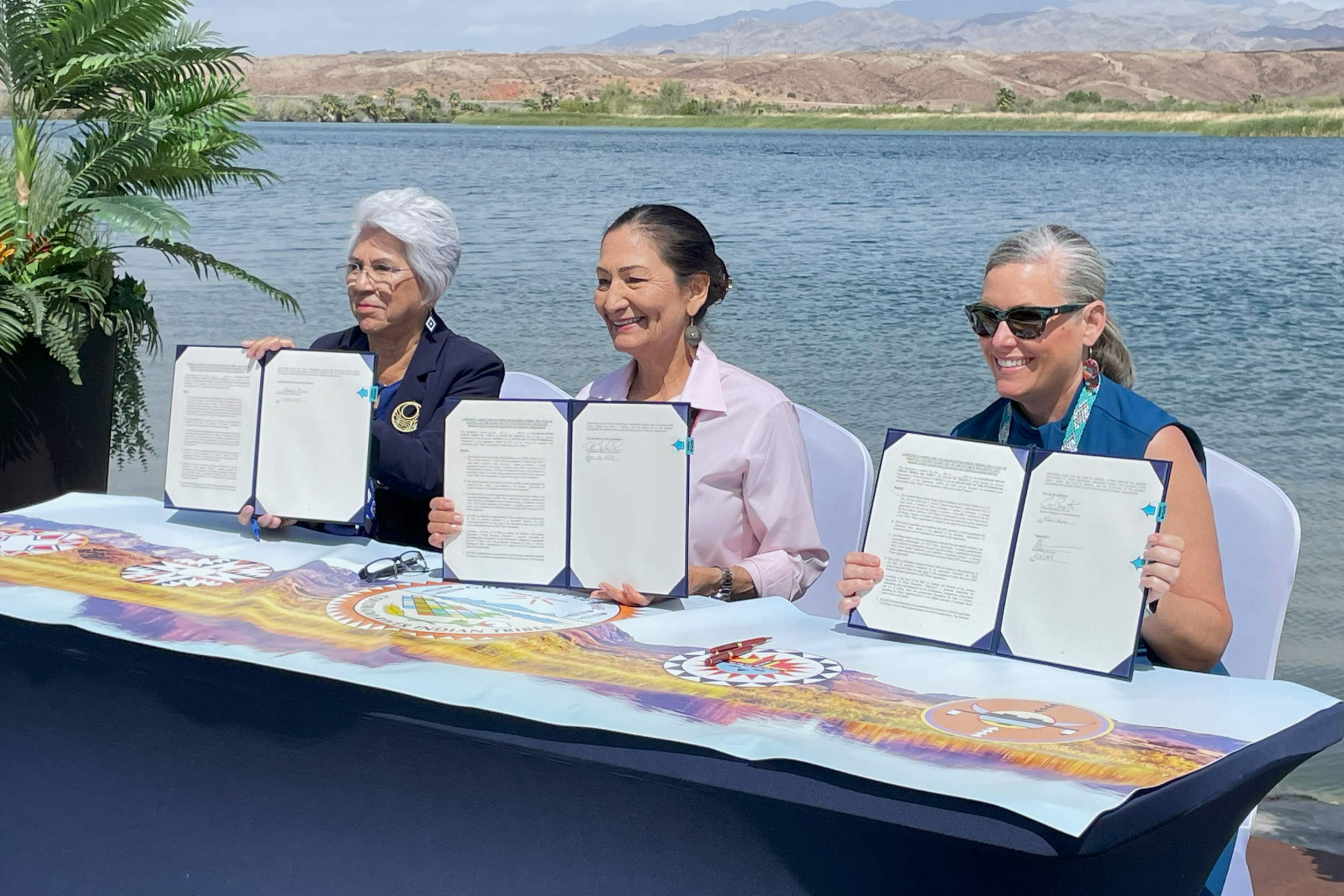
The Colorado River Indian Tribes now have the ability to lease their water rights off-reservation, a move that could ease pressures on communities facing the effects of climate change through drought. The option may prove to be financially beneficial for the Colorado River Indian Tribes, also known as CRIT, but experts say the ability of the tribe to enter the water market is an outlier: For Indigenous Nations in the Southwest with a desire to sell their water, the process is so convoluted, it may take years before tribes, or non-tribal communities to see any financial benefit or much needed water.
This month, CRIT leadership, Interior Secretary Deb Haaland, and Arizona Governor Katie Hobbs signed a historic agreement on the banks of the Colorado River, allowing their water to be leased to off-reservation parties like government entities and corporations. “This is a significant event in the history of CRIT. These agreements clear the path for CRIT to be finally recognized as a central party in all future decisions regarding the Colorado River,” Chairwoman Amelia Flores wrote in a press release.But it wasn’t easy to get here.
CRIT comprises four tribes: the Mohave, Chemehuevi, Hopi, and Navajo, who, in 1964, secured their water rights along the river — 719,248 acre feet of water annually, making CRIT the largest water rights holders in the basin. Today, CRIT maintains a number of agricultural projects on about 80,000 acres of land, growing alfalfa, cotton, potatoes, and wheat. But much of the water infrastructure used to support those operations was built in the late 1800s and suffers from problems like unlined canals and deteriorating irrigation gates.
Around 2018, CRIT became interested in leasing water to nearby communities as a way to make money and potentially conserve water, and in 2022, Congress passed the Colorado River Indian Tribes Water Resiliency Act, legislation that would allow CRIT to enter into water sharing agreements with the federal government and the state of Arizona. But this need for legislation is the central issue: Indigenous Nations are not allowed to lease or sell their lands or water without congressional approval due to the Indian Non-Intercourse Act passed in 1834. According to Daniel Cordalis, an attorney with the Native American Rights Fund, it’s a law that has long outlasted its usefulness.
“Tribes should be able to manage and derive benefit from all their water rights and be an active part of solving the Colorado River’s water use puzzle,” said Cordalis. “As it stands now, only a few tribes can participate in a truly meaningful way.” Read Next: Tribes in the Colorado River Basin are fighting for their water. States wish they wouldn’t.
Jessie Blaeser, Joseph Lee, & Anna V. Smith, High Country News
Another tribal community, the Gila River Indian Community, a few hours southwest of CRIT, has been able to lease water for decades. After securing their water rights in 2004, Gila River negotiated a settlement in exchange for federal funding for water infrastructure and access to water delivery systems to the tune of $850,000. Originally they asked for 2.1 million acre feet of water, but they received 653,500 acre feet. The state and Interior still have a say in what they are allowed to do with their water.
But again, these two tribes are the outliers — most tribes still can’t lease their water. In order to get on the water market, tribes have to figure out how much water is theirs, have their right to that water recognized by the federal government, petition Congress for permission to lease some of that water, then get state and federal officials to sit down and sign an agreement that allows that tribe to enter into additional agreements that must then be approved by those same state and federal officials.
Liliana Soto, the press secretary for Arizona Governor Katie Hobbs, she said that water agreements with tribes could lead to water conservation, shortage mitigation, and alternatives to groundwater use.
“The state’s collaboration with CRIT has been key to making this leasing possibility a reality, and Governor Hobbs sees this as one of the many ways we are strengthening partnerships with tribal nations,” she said.
Another solution to this long water leasing process is to create a uniform system for tribes to enter into off-reservation leasing. Samuel Joyce is an attorney with a focus on tribal law, who this year published in the Stanford Law Review about the issue with CRIT’s situation and the larger implications. As the Colorado River Indian Tribes Water Resiliency Act only applies to one tribe, Joyce argued that Congress could pass legislation that would make it easier for tribes to enter the water market.
Joyce also recognizes that legislation should be coupled with a streamlined process to settle water rights for nearly a dozen tribes that are currently awaiting court decisions. Read Next: Supreme Court hears Navajo demands for Colorado River water rights Jake Bittle & Maria Parazo Rose
“Reforms to make it easier for tribes to quantify their water rights should accompany leasing authorization,” Joyce wrote. “Even though tribes have senior water rights, political opposition will only grow as non-Indian users expand and climate change further reduces available water in the Colorado basin, putting priority on quantifying tribal water rights now.”
In another paper released last year, written by Bryan Leonard, a professor of environment and natural resources at the University of Wyoming, tribes were estimated to earn between $938 million and $1.8 billion in revenue a year if they were able to use all of their water allocations. Currently, tribes use only about 8 percent of their allocated water, and the rest flows downstream to users who essentially get it for free.
“Markets are only as good as the underlying property rights and institutions,” Leonard said. “The unfortunate thing for reservations is that they’re saddled with colonial-era institutions to manage their resources.”
Per the Colorado River Indian Tribes Water Resiliency Act, the tribe can only lease water in the Lower Basin, which is most of the state of Arizona. With a population boom in Phoenix, only a few hours away from CRIT, the tribe’s water could help the next influx of those flocking to the West.
This article originally appeared in Grist at https://grist.org/indigenous/tribes-could-lease-their-water-to-dry-states-why-is-it-so-hard/.
Grist is a nonprofit, independent media organization dedicated to telling stories of climate solutions and a just future. Learn more at Grist.org.

I wrote this on the occasion of Greg Hobbs’ retirement from the Colorado Supreme Court and ran across it yesterday on the Colorado Central website (August 1, 2015):
Greg Hobbs is calling it quits after 19 years as the Colorado Supreme Court’s “water expert.”
Early in his career he clerked for the 10th Circuit, worked with David Robbins at the EPA, and worked at the Colorado Attorney General’s office. AG duties included the natural resources area – water quality, water rights and air quality issues. He represented the Northern Colorado Water Conservancy district before forming his own firm, his last stop on the way to the Court.
He told the Colorado Statesman that he always had his eye on the Supreme Court. While serving at the 10th circuit, Judge William Doyle told encouraged him to set his sites on the Supreme Court, saying “They do everything over there.”
When he appointed Hobbs to the court, Governor Roy Romer told him to “get a real tie,” according to the Statesman. A bolo tie, as Hobbs usually wears, didn’t seem to qualify.
The justice is hardworking outside his court duties. He is often asked to speak at conventions and meetings around the state. He is deeply driven to learn about others and to share his knowledge of law and history.
A few years ago, over in Breckenridge, the Summit Daily News reported that Hobbs said, “The water ditch is the basis of civilization.”
His passion is to explain current opportunities and problems within a historical context. He describes himself as a “failed PhD,” having dropped out of a PhD Latin American History program at Columbia University.
One opinion in particular illustrates the importance of history to Hobbs:
The University of Denver Water Law Review honored Justice Hobbs at their annual shindig. Former Justice Mike Bender told attendees about a case where a man had been arrested after police entered and searched his zippered tent in a campground.
In his opinion, Hobbs detailed the history of Coloradans that lived in tents. The plains Indians and their teepees, the miners camps dotted all over the mineral belt and elsewhere, and more than a few homesteaders, also. He said that in Colorado, there is an expectation of privacy when you close up your tent dwelling, and that it is no different from the expectation for a more permanent structure.
The police violated the man’s Fourth Amendment rights by not obtaining a search warrant, he said.
The justice credits luck for his interest in water law. He got in on the ground floor of the environmental movement during the early days of the Clean Water Act and the Clean Air Act.
He has a deep and abiding respect for Colorado water law.
During his time on the court, there were two interesting cases dealing with the “speculation doctrine” – that is, a water diverter must put the water to beneficial use, not hold on to it and auction it to the highest bidder.
Pagosa Springs Water and Sanitation District was told it was not allowed a 100-year planning horizon. High Plains A&M was denied a change of use – agricultural to municipal and industrial – for lower Arkansas Basin water on the High Line Canal, because they didn’t have any firm customers for the water they were changing.
The Court recognized the Legislature’s legal ability to create whitewater parks as a beneficial use.
Perhaps one of the most remarkable insights that Justice Hobbs realized pertains to environmental flows within Colorado water law:
When Amy Beatie, director of the Colorado Water Trust, was clerking for the justice, she told him that her primary interest was working for the environment. He advised her to go into private practice, learn about the workings of water law, the mechanics and hydrology of diversions, and the art of finding common ground at water court. Then, he said, have faith that there will be a way to work for the environment within the water rights system.
Ms. Beatie paid attention.
Her organization just secured an instream flow right for the Colorado Water Conservation Board on a tributary of the Gunnison River, the Little Cimmaron River. The trust purchased shares of the McKinley ditch and assigned them to the CWCB – the only entity under state law that can hold rights for instream flows.
The water rights are senior and near the confluence with the Gunnison. Therefore, in times of low flows they are capable of calling out diversions above them. Water bypasses the McKinley headgate and stays in the stream for the fish and other critters. Further development of junior water rights won’t affect the arrangement, since the instream flow will always be in line ahead of newer ones.
This agreement and decree were a big deal since they were the first of their kind, with a willing seller, an organization dedicated to finding deals that benefit instream flows, an entity that can legally hold those rights, and an active water rights market.
At this summer’s Martz Conference hosted by the CU law school, Justice Hobbs spoke about Colorado’s water market. Many groups and individuals decry the current state of water in the western U.S. Brad Udall, for example, told attendees at last fall’s Colorado River District Annual Symposium, that we are living with 19th-century laws, 20th-century infrastructure and 21st-century problems.
Hobbs reminded attendees at Martz 2015 that Colorado has the most active water market in the U.S. and it evolved under those 19th-century laws. Colorado water law is there to protect all appropriators and works very well, albeit slowly. Things move along more quickly as case law grows.
The basis of Colorado water law is the “doctrine of prior appropriation,” which is really a doctrine of scarcity, as just about anyone can administer a stream with average or above average flows. The art comes when there are low flows, so the state engineer has the priority system in his toolbox for those dry times.
Greg has become a friend to me over the years and I already miss him on the court.
He assures me that he will keep writing and speaking. After all, he asserts, “Coloradans love a good story.”
You tell a good story, Greg.
John Orr covers Colorado water issues at Coyote Gulch: www.coyotegulch.net
Published in 2015 August

Click the link to read the article on The Revelator website (John R. Platt):
May 13, 2024
Science just proved it: Conservation efforts around the world are working.
According to a study published April 26 in the journal Science, human efforts to help endangered and at-risk species have proven overwhelmingly successful at improving their status.
The researchers — 33 authors from universities and conservation groups — examined 186 studies that measured the effectiveness of conservation efforts over time. The meta-study put the results clearly:

Interestingly, the study found that more recent conservation projects were the most likely to have gone well. We’ve learned a lot over the past few decades, which means we’re doing better all the time.
Toward that point, the paper found that even conservation efforts that don’t work can provide critical information to help future programs, as two of the study authors wrote for The Conversation: “For example, in India, removing an invasive algae simply caused it to spread elsewhere. Conservationists can now try a different strategy that may be more successful.”
And here’s the even bigger takeaway: The benefits aren’t just for the species that are direct targets of conservation efforts. “One of the most interesting findings was that even when a conservation intervention didn’t work for the species that is was intended, other species unintentionally benefited,” lead author Penny Langhammer, executive vice president of the conservation group Re:wild, told BBC News. That often happens when conservationists mitigate a threat in order to help one species but help other nearby plants or animals in the process.
Of course, we could be doing even better: Even though we know conservation works, there’s just nowhere nearly enough funding to help every species in need. As the authors wrote in The Conversation:

The paper itself lists dozens of great conservation examples, but you can find even more in recent news:
- Critically endangered red wolves (Canis rufus) have enjoyed a much-needed baby boom, with eight new cubs born to a pack in North Carolina last month. Red wolves only have one breeding male left in the wild, so these cubs represent the future of the species. (The proud papa came from a conservation breeding center in Washington state after the previous male was killed by a car — further proof that these wolves wouldn’t continue to exist without dedicated humans looking out for their future.)
- Devil’s Hole pupfish (Cyprinodon diabolis) are also having a helluva good time and have reached their highest spring population level in 25 years. At just 191 tiny fish, they’re not exactly populous, but this is a huge boost from 2013, when the species’ spring population plummeted to a low of just 35. This sets them up for a good breeding season ahead, when their population (which fluctuates according to the time of year) could hit 500 or more.
- Meanwhile giant ground pangolins (Smutsia gigantea) have returned to Kenya for the first time in more than half a century. Conservationists put the current population at just 30-80 animals, but it’s a start, and it’s all due to the nonprofit Project Pangolin’s work to remove electric fences and other threats that prevented the return of these heavily poached animals.
- Similarly, spotted hyenas (Crocuta crocuta) have taken up residence in Gabon for the first time since 1949. A few individuals had briefly wandered into the country over the past few decades, but none of these important predators had stuck around. Now a new study reveals that some of them have finally decided to call their former country home once again — a call for scientists to understand how they did it so others can follow.
- Also in Gabon, a new study shows that forests certified by the Forest Stewardship Council in that country and the Republic of Congo now enjoy greater abundances of large mammals such as elephants and gorillas, as well as other critically endangered species.
- Asian elephants living in recently protected habitats in Cambodia appear to have increased in number and now travel in groups of up to 20 or 30, compared to groups of 3-5 just a few years ago.
- In the UK 150 harvest mice (Micromys minutus) have been reintroduced into a nature reserve near London, the first time they’ve lived in the area since 1979. Conservationists have protected meadows and created wildlife corridors to make the wooded reserve more hospitable to the rewilded mice.
That just scratches the surface, but it proves a point: Humans pushed most of these species toward extinction, but we can also lift them back, given enough time, effort and funding.
Counterpoint
Of course, not everything goes well for imperiled wildlife.
As Mongabay reports, a single gang of poachers may have killed at least 10% of the entire Javan rhino species (Rhinoceros sondaicus) since 2019. A 2021 camera-trap survey put the Javan rhino population at 34 confirmed individuals, although a government report earlier that year estimated the number at 76. Either count was bad enough, and now this gang is suspected to have killed at least seven of the rhinos, according to government officials, pushing the species ever closer to extinction.
This brutal news hit the environmental media like a lead balloon. Other than Mongabay, no media outlets covered the story in English in the week that followed, according to freelance journalist Jeremy Hance broke the news and later wrote on social media, “How can we do anything about the mass extinction crisis if the news refuses to cover it?”

This story — and the journalistic apathy around it — cuts deep. I’ve long been vocal in my criticism that environmental journalism doesn’t do enough to cover wildlife issues and the extinction crisis. Climate change — as critical as it is — has sucked much of the air from the room and left little space for covering other topics.
Part of the challenge is that bad news about endangered species and wildlife is often so heart-wrenching. Stories like poachers killing Javan rhinos embody the cruelest aspects of human character and social conditions. Faced with painful facts and few actionable solutions, many readers tune it out and turn the page.
But we can’t turn a blind eye to the multiple crises around the world. The media needs to cover them, and people who care need to read and share them along with the good-news stories — to help inspire further action and fight the overwhelming ennui that can settle on us in the face of destruction.
If the bad news makes you angry, use that anger. And look to the success stories to keep you going and build on what’s already been done.

Click the link to read the article on the Colorado Newsline website (Chase Woodruff):
May 13, 2024
Despite bipartisan agreement on a handful of key reforms, Colorado’s 2024 legislative session highlighted the deep divides and entrenched interests that define some of the state’s thorniest and longest-running environmental challenges.
Colorado Democrats and environmental groups began the year with an ambitious plan to crack down on ozone pollution from the oil and gas industry. It was the most significant new attempt to regulate drilling since a sweeping health and safety overhaul passed by Democrats in 2019, and the opposition it drew from deep-pocketed industry groups was similarly intense.
In an eleventh-hour deal brokered by Gov. Jared Polis, proponents abruptly changed course, agreeing to drop most of the proposed regulations in favor of a new fee on oil and gas production to fund public transit and conservation projects. Other bills approved by lawmakers this session, which ended Wednesday [May 8, 2024], aim to establish or expand protections for disproportionately impacted communities, drinking water supplies and wild streams and wetlands.
“The 2024 legislative session was a win for the climate, for Colorado consumers, and for equity,” Elise Jones, executive director of the Southwest Energy Efficiency Project, said in a statement. “In particular, lawmakers approved unprecedented funding for bus and rail service across the state, and adopted a package of climate-friendly land use bills to enable more affordable and abundant housing opportunities in Colorado’s cities along transit lines, while reducing transportation pollution and traffic congestion.”
Separately from the package of ozone reforms, lawmakers for the first time considered a bill that sought to put an end date on oil and gas extraction in Colorado as part of the state’s efforts to address climate change. Similar plans to phase out drilling are underway in states like California and in countries around the world, but Colorado’s Senate Bill 24-159 likely never stood a chance; facing a veto threat from Polis, a Democrat, and lacking support from key Democratic lawmakers, it died in its first committee hearing in March.
Air and water quality
Senate Bill 24-229: Ozone mitigation measures
One of two bills introduced late in the 2024 session as part of the compromise on oil and gas issues, SB-229 will make a relatively minor set of reforms to the way state agencies issue permits and enforce regulations on oil and gas operations. It will give Colorado’s Energy and Carbon Management Commission more explicit power to penalize operators and address the problem of orphaned wells, and codify a mandate on oil and gas producers to reduce emissions of so-called ozone precursors, which Polis first issued in an executive order last year.
The bill has not yet been signed by the governor.
Senate Bill 24-230: Oil and gas production fees
Beginning in July 2025, this bill will levy new fees on oil and gas production in Colorado. The per-unit fees will be adjusted quarterly based on benchmark prices, but will roughly equate to a surcharge of about 0.5% per barrel of crude oil, and will raise between $100 million and $175 million in a typical year. The revenue will fund projects to offset the impacts of oil and gas pollution, with 80% allocated to public transit projects and the remainder used by Colorado Parks and Wildlife for land acquisition and habitat projects.
SB-230’s fees will substantially increase the share of oil and gas production revenue collected by the state, while doing little to offset its exceptionally low rates of conventional taxes on the industry, a Newsline analysis found.
The bill has not yet been signed by the governor.
House Bill 24-1338: Cumulative impacts and environmental justice
Sponsored by Democratic state Reps. Manny Rutinel of Commerce City and Elizabeth Velasco of Glenwood Springs, HB-1338 directs the Colorado Department of Public Health and Environment to carry out the recommendations of the state’s Environmental Justice Action Task Force. Those measures include increased oversight of the state’s only petroleum refinery, the Suncor facility in Commerce City, and the creation of a “rapid response” inspection team to act quickly to address air quality complaints.
The bill has not yet been signed by the governor.
House Bill 24-1379: Regulate dredge and fill activities in state waters
Sponsored by Democratic House Speaker Julie McCluskie of Dillon and Republican state Sen. Barbara Kirkmeyer of Weld County, HB-1379 reestablishes protections for certain streams and wetlands following a 2023 Supreme Court decision that excluded them from the federal Clean Water Act. The bill creates a new CDPHE permitting program to regulate dredge and fill activities that impact those waters, with a variety of exemptions, including for many agricultural operations.
The bill has not yet been signed by the governor.
Senate Bill 24-197: Water conservation measures
Another bipartisan water bill, SB-197 would implement several conservation proposals endorsed by last year’s Colorado River Drought Task Force, including the expansion of a program for the temporary loaning of water rights to the Colorado Water Conservation Board to protect the environment.
The bill has not yet been signed by the governor.
Senate Bill 24-81: Perfluoroalkyl and polyfluoroalkyl chemicals
SB-81 expands the state’s ban on products containing cancer-causing PFAS, so-called “forever chemicals,” to include new categories of items like nonstick cookware, ski wax and artificial turf.
It was signed into law by Polis on May 1.
Land use and transportation
For the second legislative session in a row, climate and environmental advocates lined up in support of a push to steer Colorado land-use policy towards more abundant, higher-density housing development. Proponents say the reforms are a critical step towards meeting the state’s clean transportation and energy goals, but they’ve run into stiff opposition from local governments and homeowners who object to the state interfering in local zoning and development policies.
Following the defeat of a sweeping package of land-use reforms in the 2023 legislative session, sponsors revived several of its components in piecemeal fashion this year.
House Bill 24-1313: Transit-oriented communities
The most ambitious of 2024’s housing bills, HB-1313 sets goals for Colorado’s most populous cities to increase housing density in areas nearest to public transit stations. It establishes a $35 million fund to support infrastructure in communities that meet the goals, but a controversial provision that would’ve withheld state highway funding from local governments that failed to comply was stripped from the bill prior to its passage by the Senate.
The bill was signed into law by Polis on Monday.
House Bill 24-1152: Accessory dwelling units
Accessory dwelling units, sometimes called “granny flats,” are housing units built on a property with an existing single-family home. HB-1152 would legalize the construction of ADUs across virtually all residential areas in Colorado’s most populous cities and suburbs, prohibiting local governments from restricting their construction on any land zoned for single-family residential development.
The bill was signed into law by Polis on Monday.
House Bill 24-1007: Prohibit residential occupancy limits
HB-1007 bars local governments from regulating the number of unrelated people who can live together in a housing unit, except for standards enforced based on building or fire codes. Low occupancy limits in cities like Boulder — which prohibited more than three unrelated people from living together until last year, when it raised the limit to five — have been a flashpoint in local battles over housing affordability.
The bill was signed into law by Polis on April 15.
House Bill 24-1304: Minimum parking requirements
HB-1304 would prohibit local governments from enacting minimum parking requirements for new housing developments in areas nearest to transit service. Critics of such ordinances say they inflate the cost of constructing new housing units while exacerbating traffic congestion and vehicle pollution.
Polis signed the bill into law on May 10.
Senate Bill 24-184: Support surface transportation infrastructure development
As the state ramps up efforts to win federal funding for a new passenger rail system along the Front Range, SB-184 would create a new revenue stream for rail infrastructure spending by levying a new fee of up to $3 per day on rental cars. Transportation officials said the $58 million raised annually by the new fee will help the state “compete effectively” for federal passenger rail grants.
The bill has not yet been signed by the governor.
Click the link to read the article on the 8NewsNow.com website (Greg Haas). Here’s an excerpt:
May 10, 2024
A late-season bump from storms in the Colorado Rockies has boosted snowpack levels, helping the region rebound after levels fell below normal at the end of April. That’s important for Las Vegas, which depends on the Colorado River for 90% of its water. Snowpack is currently at 107% of normal in the Upper Colorado River Basin, up from just 89% on May 1. On April 1, typically the peak for snowpack levels, data showed the amount of water stored in the snowpack at 111% of normal.
Separately, Northern Nevada counties got some good news as the U.S. Department of Agriculture said Lake Tahoe would fill for the first time since 2019. The Nevada Water Supply Outlook Report showed snowpacks in the eastern Sierra Nevada far above normal levels for the second consecutive year. Most key reservoirs in Northern Nevada are expected to fill this year. The dramatic snow levels in the Sierra Nevada last year erased a two-decade megadrought in that region, according to a report by The Associated Press.
That won’t have any impact on Southern Nevada, where 90% of the water used comes from the Colorado River. The weather that has the greatest effect on the Las Vegas valley’s water supply happens hundreds of miles away. Lake Mead had fallen to 35% of capacity as of Thursday, according to data from the U.S. Bureau of Reclamation. Water from snowmelt in parts of Colorado, New Mexico, Utah and Wyoming feeds the flow of the river as it makes its way to Lake Powell. From there, water flows down the Grand Canyon and into Lake Mead.

Click the link to read the article on The Aspen Daily News website (Austin Corona). Here’s an excerpt:
Ruedi Reservoir is expected to hit full capacity for only the second time in five years, according to projections shared by reservoir managers. The managers don’t know exactly when the reservoir will hit capacity, though Tim Miller, hydrologist for the Bureau of Reclamation — the federal agency that operates Ruedi Dam — said it will likely stay full through July. Miller said calls for Ruedi water farther down the Colorado River could change that timeline. Ruedi is currently 68.8% full.
Ruedi did not reach its full capacity for three years between 2020 and 2022. Low runoff kept the reservoir from filling in 2020, and then overshoots in inflow projections and dry soils caused the reservoir to miss its capacity again in 2021. Reservoir levels then dropped to a 20-year nadir in March 2022 and never quite reached full capacity during a rebound that summer. Those three years were the only multiyear stretch in which Ruedi failed to fill in the last 10 years. Reservoir levels also fell short in 2018. Ruedi ended its dry streak after a wet winter in 2023, with Miller reporting in August that last year was almost flawless for reservoir operations.
This year, Miller said snowpack and runoff projections look similar to 2023. Water supply forecasts from the National Oceanic and Atmospheric Administration’s Colorado Basin River Forecast Center project a total Fryingpan River April-July runoff volume at Ruedi roughly 10% higher than projections from the same time in 2023 (this year’s May 1 projection is 135,000 acre feet). Miller said the Ruedi may receive even greater flows than expected this year because of operational issues at a connected facility on the eastern slope. Miller said water managers may have to leave more water in the Fryingpan River this year than usual if Turquoise Lake, an eastern slope reservoir that receives Fryingpan water through a tunnel under the continental divide, fills up. Miller said Turquoise’s outflow will be limited this year because both pump/turbine units at the Mount Elbert pumped-storage powerplant, which constitutes one outlet for the reservoir, are not operating this summer.

Click the link to read the article on The Land Desk website (Jonathan P. Thompson):
May 10, 2024
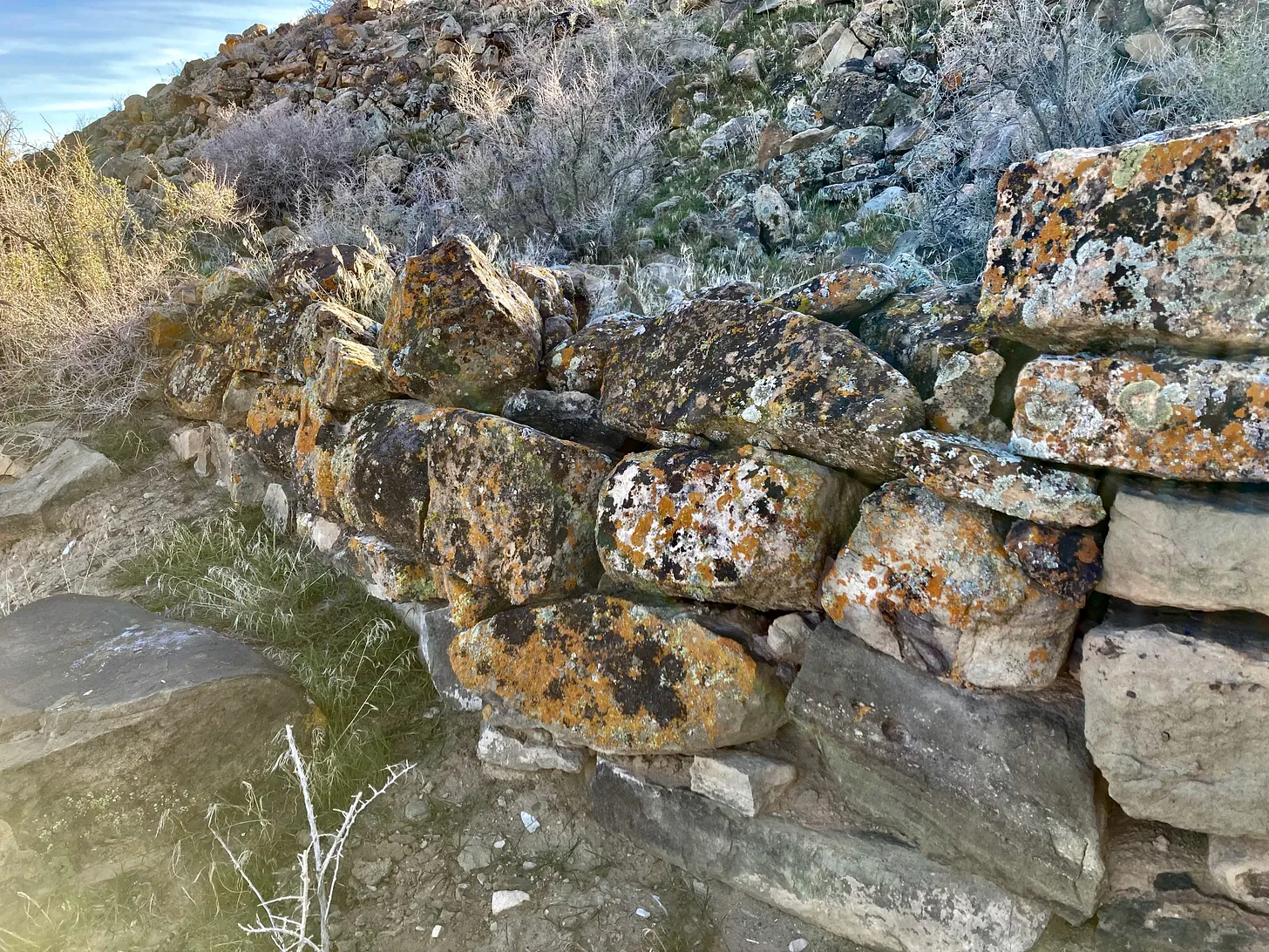
NEWS: The Bureau of Land Management cancelled 25 Trump-era oil and gas leases totaling more than 40,000 acres in the Lands Between, an area in southeastern Utah rich with cultural resources between Bears Ears and Hovenweep/Canyon of the Ancients National Monuments.
CONTEXT: There is a place known as the Great Sage Plain or, in more recent times, the Lands Between, a place of mesas and sagebrush and broad canyons spread that spread out north of the San Juan River and west of the Utah-Colorado state line. The beauty is more subtle here than in the serpentine gorges to the west, but it’s also ubiquitous, found in lichen-splattered stone, in the way the light plays across rain-soaked sagebrush, in the lascivious dusk bloom of the sacred datura.
And human history is omnipresent here, layers upon layers of reminders of those who came before. Cultural sites abound, some obvious, many barely discernible. The Lands Between is one of the most archaeologically rich swaths of land in the nation. And yet, the place is often ignored and more often abused.
In 2018, as part of its marauding quest for “energy dominance,” the Trump administration offered up thousands of acres in the Lands Between for oil and gas leasing. Tribal nations with ancestral ties to the land, environmental groups, and historic preservation advocates protested nearly all of the parcels. The administration cast the protests aside, however, and in March and December of that year, energy company representatives logged onto EnergyNet.com and bid between $2 and $91 per acre for the right to drill, with companies like Wasatch Energy, Kirkwood Oil & Gas, and Ayers Energy walking away with the spoils.
Friends of Cedar Mesa (now Bears Ears Partnership), sued the Trump administration, alleging that the BLM violated federal environmental law by issuing the leases. Early last year the BLM agreed to re-evaluate the leases, and launched a new environmental assessment process. That process culminated this week with the cancellation of 25 of 28 of the leases under review, with three leases affirmed.

Reasons for the decision included:
- More than 900 National Register-eligible historic sites were identified within the leases, along with hundreds more within the half-mile buffer zone around the leases;
- Twelve of the leases lie within the Alkali Ridge Area of Critical Environmental Concern and contain a total of 806 documented cultural resources, including Three Kiva Pueblo.
- “Recent concerns brought forth by the Pueblo of Acoma, including the need to conduct a ‘more comprehensive review’, and a ‘structured consultation process with the Pueblo of Acoma and other tribes, ensuring that tribal expertise and cultural knowledge guide the evaluation and management of these lands.’
While compelling, I was most interested in “topographic anomalies” identified by LiDAR, or a sort of laser-based radar used more and more frequently in archaeology, especially to find ancient “roads” such as the ones that radiate out from Chaco Canyon. The agency was tipped off to these anomalies by Winston B. Hurst’s draft report titled: “LiDAR’s Gifts: Firstlook Insights into Puebloan Roads and Berm-Swale Field Systems in Utah and Neighboring Sections of the Northern San Juan Region.” Hurst identified a number of these features within the lease areas and their five-mile buffer zones.
In its record of decision cancelling the leases, the BLM writes that the anomalies, which potentially are berm-swale fields, ancient roads, or other architectural features with unknown function, warrant more study, and adds:

So there you have it. It’s probably not a good idea to go in and wreck these significant cultural objects with well pads and drilling rigs and pipelines and roads. And the BLM seems to understand that, at last.
“Acoma is deeply grateful for the BLM’s decision to cancel these leases, which affirms the importance of this landscape for the Pueblo of Acoma and other Pueblos and Tribes. This landscape is a living testament to our ancestors and our ongoing cultural traditions. Preserving these areas from development allows us to maintain our deep connection to our history and educate future generations about their rich cultural heritage,” said Governor Randall Vicente of the Pueblo of Acoma in a written statement.
But the fight’s not over yet. Acoma is also challenging leases in the same area sold in 2019.
Read more about the Lands Between, national monuments, and the inadequacy of “identify and avoid”. But first, subscribe to get a taste of these delicious archives:
State Line JONATHAN P. THOMPSON AUGUST 13, 2021
The following is from Sagebrush Empire: How a Remote Utah County Became the Battlefront of American Public Lands, by Jonathan P. Thompson. Torrey House Press, 2021. I am walking across the southeastern Utah desert, looking for the Colorado state line on an overcast day in early March. I think that maybe if I could just see the state line, experience it,…Read full story
The Meaning of Monuments JONATHAN P. THOMPSON JANUARY 22, 2021

When President Barack Obama established Bears Ears National Monument just over four years ago, conservationists and tribal leaders were …Read full story
Abandoned oil and gas wells threaten cultural sites JONATHAN P. THOMPSON MAR 5, 2024

Archaeology Southwest, an Arizona-based nonprofit, recently released an interesting and somewhat alarming report by Paul Reed, a New Mexico preservation archaeologist, on orphaned and abandoned oil and gas…Read full story
📸 Parting Shot 🎞️

Click the link to read the article on the Craig Daily Press website (Ashley Dishman)
May 12, 2024
A major project to update the Maybell Diversion and headgate on the Yampa River is nearing completion as its users prepare for irrigation season. The Nature Conservancy, Maybell Irrigation District and JHL Constructors have worked together on the $6.8 million endeavor, which makes possible the first remote operation of the headgate in over 126 years.
Maybell is home to one of the largest irrigation diversions on the Yampa River. It provides water to about 2,000 acres of irrigated hay meadows in Northwest Colorado through a series of lateral ditches that come off the Maybell Diversion located just west of Craig toward Dinosaur National Monument…In the past, the headgate was manually operated, requiring a 3-mile round-trip hike and special tools and equipment to open the gates to the ditch. This often meant water was not used efficiently or at the most opportune times for ranchers. In addition, the Maybell Diversion has previously posed challenges for both fish and recreational boat passage through that part of the river in Juniper Canyon. In the past, fish movement was constrained by low river flows, especially during irrigation season. The Maybell reach has been considered a recreational-use hazard due to landslides, large boulders that block the river and push-up dams that hinder fish and boaters alike.
The newly modernized diversion and headgate will allow for remote operation and improved water delivery control to agricultural lands. It also aims to improve fish passage and recreational boat access. The redesign will connect two sections of floatable river with a constructed riffle at the diversion.
“We are excited to have this project completed,” said Mike Camblin, president of the Maybell Irrigation District. “Water is a precious resource, and this project allows us to manage it in the way the 21st century demands. We’re grateful to our partners, The Nature Conservancy, JHL Constructors and others who made this possible.”

Click the link to read the article on the KUER website (David Condos). Here’s an excerpt:
May 13, 2024
Runoff from mountain snowpack is particularly precious in Utah. It provides 95% of the state’s water supply. In recent years, however, getting above-average snowpack hasn’t necessarily led to above-average runoff. Historically, water managers could count on those numbers to more-or-less match, said Colorado River Authority of Utah Chair Gene Shawcroft. This discrepancy — and the uncertainty it brings — makes the already tricky job of managing water in the West even harder, he said.
“That’s part of the challenge we have with everything we do in the water world. Not only are we pressured to make sure there’s water for the future. We’re also wrestling with, ‘What happens if our water supply is less than what we’ve anticipated?’”

When snowpack peaked in the Colorado River’s Upper Basin in early April, it was 112% of its historical normal. But the actual runoff for April was just 99% of normal. As of May 10, snowpack was still above average at 107% of normal. The most recent streamflow forecast for May-July, however, predicts runoff to only be 87% of normal. Localized examples of this gap show up in southern Utah, too. In the southwestern region, which includes St. George and Kanab, snowpack levels hit 101% of normal on May 1. But the May-July streamflow forecast expects runoff to be just 60% of normal. The Escalante-Paria basin from Bryce Canyon National Park to the southern edges of Lake Powell had snowpack levels that were 262% of normal on May 1, but the latest streamflow forecast anticipates runoff to be 101% of normal…
So, why is this happening? One big factor is how parched the ground is. Soil moisture and groundwater levels are still trying to claw their way back from the extreme drought Utah had between 2020 and 2022, said Utah Snow Survey Program Supervisor Jordan Clayton. The ground became so dried out, that it soaked up a disproportionate amount of snowmelt in the subsequent runoff seasons. Even during the past two years, the ground beneath some of that snow has remained on the dry side…
Another factor is how fast the snowpack melts. If it goes quickly, the ground will likely stay saturated and a much larger percentage of the water will make it downstream. If it happens in fits and starts, however, the ground has more chances to dry out between melting periods and could absorb more of that water…
Where the snow falls also matters. As Clayton looked at Utah’s snow conditions this winter, he noticed that the middle and lower-elevation mountains had especially high snowpack levels compared to their historical normals. The problem is that most of Utah’s water doesn’t come from those lower elevations, but from sites with an altitude of around 10,000 feet.
Click the link to read the release on the NRCS website:
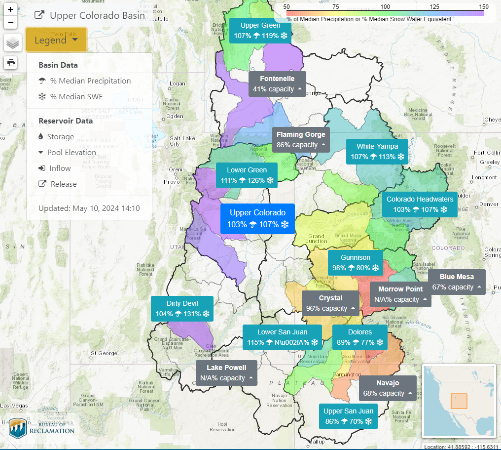
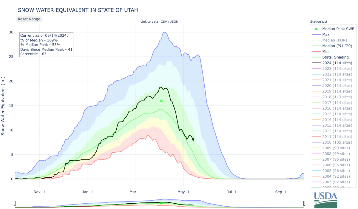
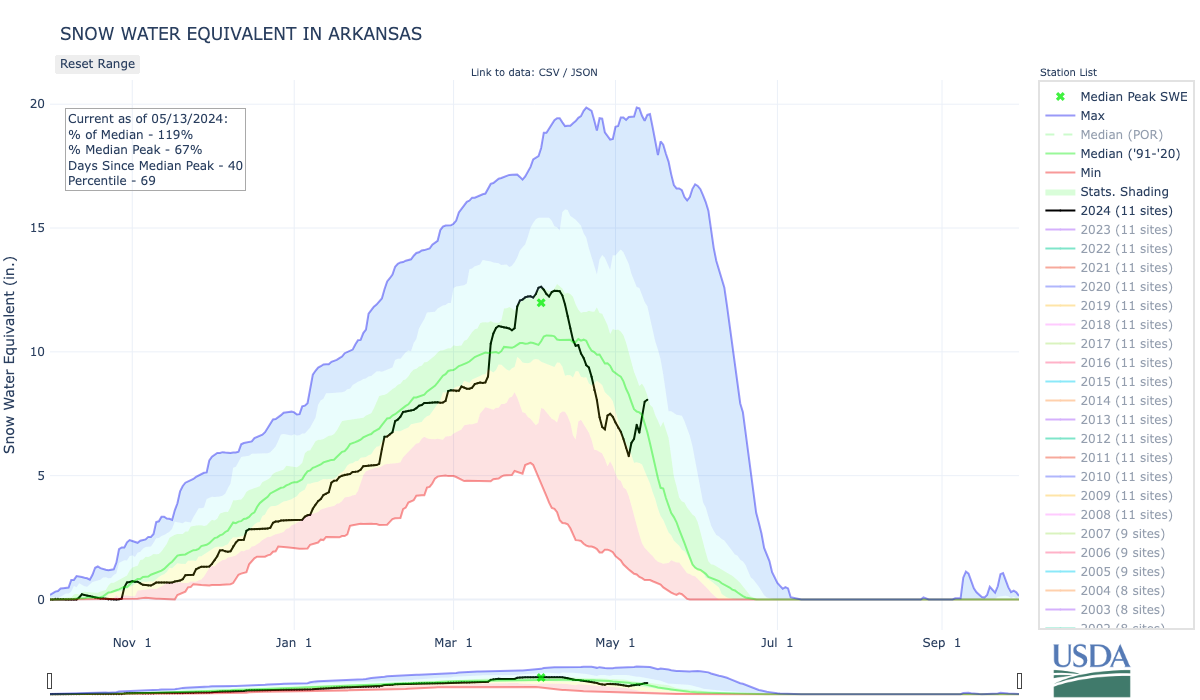
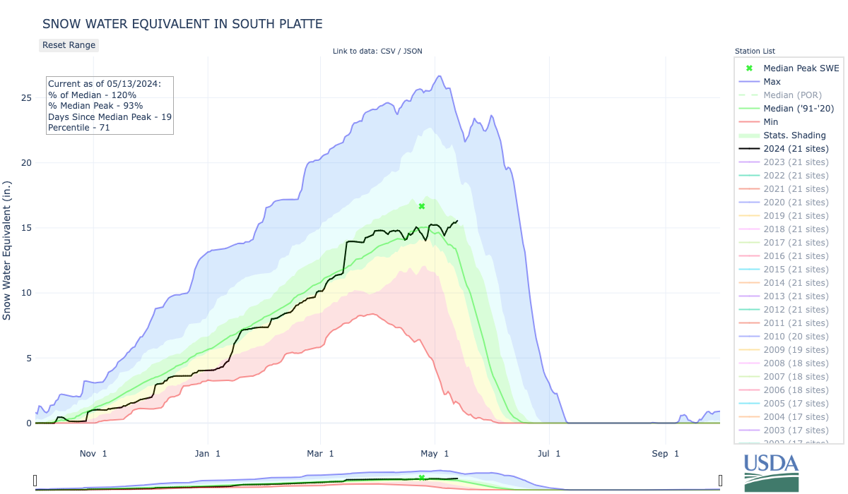
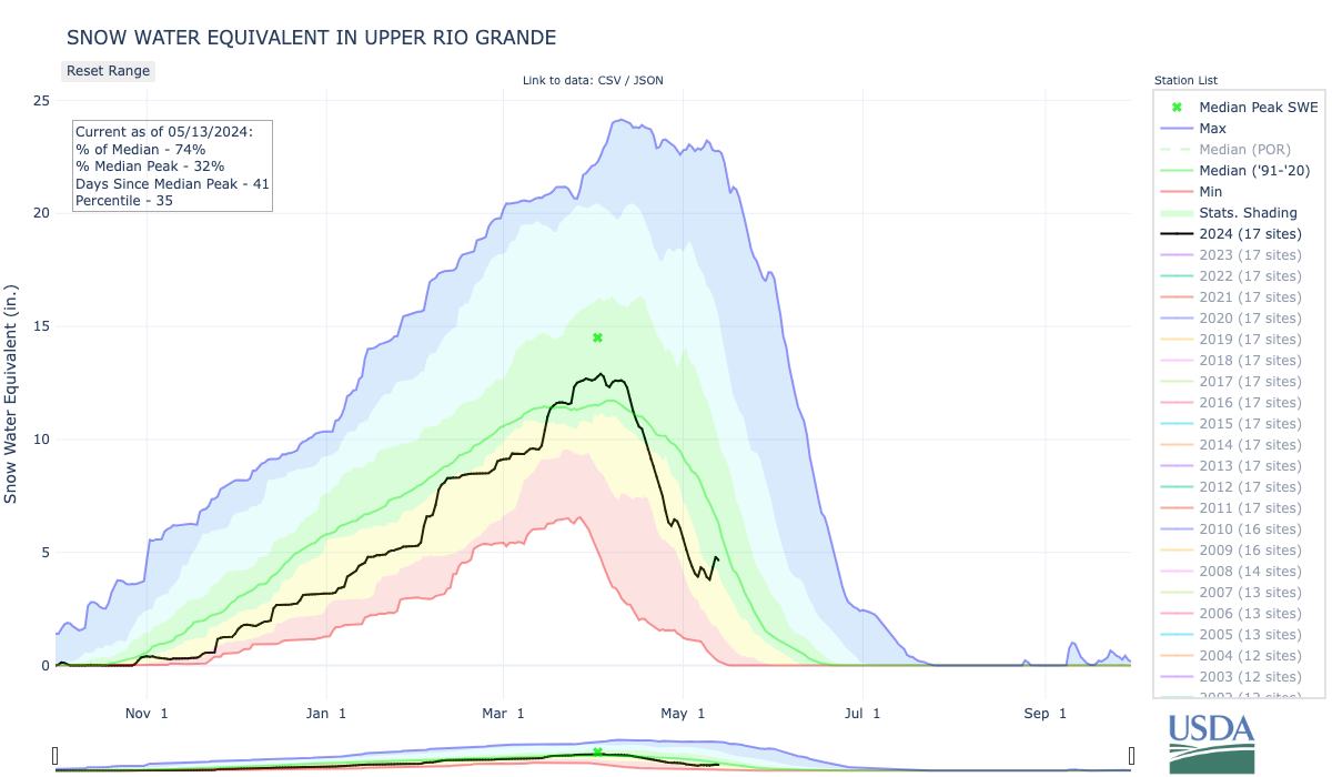
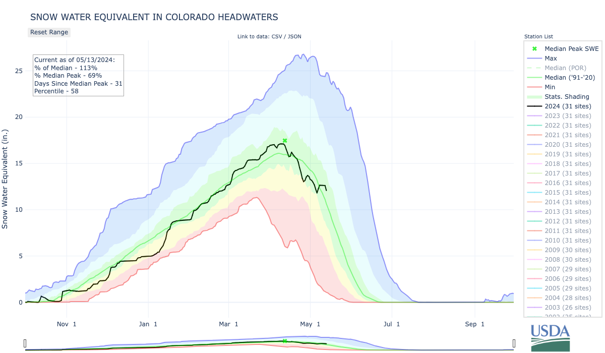
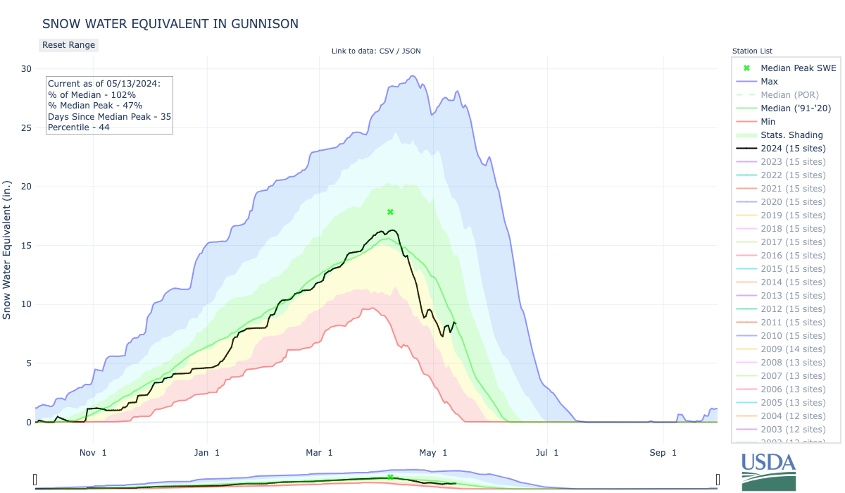
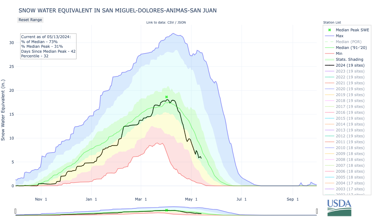
As of May 1st, 2024, Colorado’s snowpack exhibits a distinct north-south divide and is at 90% of median. The northern basins display persistent snowpack levels from 95% of median in the combined Yampa-White-Little Snake basins to 105% in the South Platte. In stark contrast, the southern basins are below median ranging from 57% in the Upper Rio Grande to 84% in the Arkansas. Statewide precipitation has reached 105% of median for the water year to date (WYTD), while April’s drier conditions have resulted in 88% of median precipitation. This monthly subnormal statewide median, when disaggregated, reveals a stark contrast in precipitation distribution, particularly with southern basins ranging from 54% to 68% and northern basins ranging from 82% to 102%. Southern basins have not only received less precipitation compared to the state’s median but also when set against their historical medians. The combined San Miguel-Dolores-Animas-San Juan (SMDASJ) basins are at 88% WYTD, dipping further to 68% for April totals.

Streamflow projections echo snowpack and precipitation variances, with the state averaging forecasts at 95% of median. A closer look reveals 34 of 86 streamflow stations predicting above median flows. The Yampa-White-Little Snake forecast an above median flow at 109%, reflecting sustained snowpack levels. Conversely, the combined SMDASJ basins, experiencing reduced snowpack at 72%, project streamflow at 73% of median. Specific sites like Navajo Reservoir inflow and the Animas River at Durango are anticipating below median streamflow at 440 cubic feet per second (CFS) and 279 CFS, respectively.
Karl Wetlaufer, a hydrologist with the NRCS Water and Climate Center, highlights the impact of recent weather patterns on streamflow projections: “The month of April brought above normal temperatures and below normal precipitation across the Upper Colorado and the Rio Grande basins. These conditions contributed to rapid snowmelt in most of the basins and above normal monthly streamflow in many sub-basins. All of these contributing factors led to a drop in total seasonal (April-July) volumetric forecasts since April 1st in most sub-basins with the exception of the Colorado Headwaters where forecasts remained most similar to last month.”
“The rapid onset of warmer temperatures in late April accelerated snowmelt rates, particularly in the Upper Colorado and Gunnison basins, highlights a potential for early peak streamflow,” comments Nagam Gill, NRCS hydrologist. SNOTEL data at the Schofield Pass and Red Mountain Pass sites in the Gunnison basin, show that snow water equivalent (SWE) was reduced to 75% and 90% of the seasonal peak, respectively, by early May. This trend is also observed at the Upper Taylor SNOTEL, where the snow water equivalent decreased to 48% of its peak by the same time, earlier than the historical median melt-out dates. Despite the past peak in SWE, ongoing weather patterns into May and June can still influence streamflow. Late spring rains, although not as impactful as winter snowpack, can help sustain streamflow and top up reservoirs levels before the drier summer months set in.
As of the end of April, reservoir storage across Colorado is at 97% of median an improvement from 86% observed this time last year. Most basins are reporting near to above median, ranging from 106% in the South Platte to 124% in the Colorado Headwaters. The combined SMDASJ basins are the exception at 84% of median slightly above last year’s 82% at this time. Despite less robust snowpack conditions this year, reservoir levels have benefited from last year’s abundant snowpack, which has helped maintain relatively high-water storage levels.

* San Miguel-Dolores-Animas-San Juan River basin
* *For more detailed information about April mountain snowpack refer to the May1st, 2024 Colorado Water Supply Outlook Report. For the most up to date information about Colorado snowpack and water supply related information, refer to the Colorado Snow Survey website.
Click the link to read the article on the KUNC website (Alex Hager):
May 10, 2024
This story is part of ongoing coverage of the Colorado River, produced by KUNC in Colorado and supported by the Walton Family Foundation. KUNC is solely responsible for its editorial coverage.
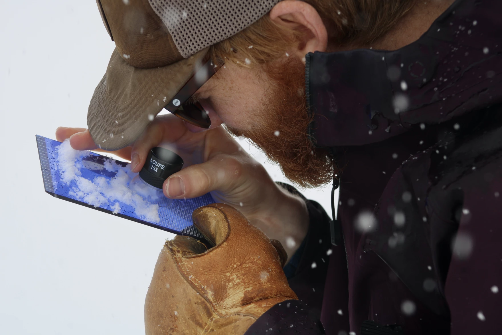
A team of researchers has been hard at work in the Rocky Mountains to solve a mystery. Snow is vanishing into thin air.
Now, for the first time, a new study explains how much is getting lost , and when, exactly, it’s disappearing . Their findings have to do with snow sublimation, a process that happens when snow evaporates before it has a chance to melt.
Perhaps most critical in the new findings is the fact that most snow evaporation happens in the spring, after snow totals have reached their peak. This could help water managers around the West know when to make changes to the amount of water they take from rivers and reservoirs.
“This lets us make much better decisions and understand processes that there was not data available to understand before,” said Jessica Lundquist, the study’s author. “These data are absolutely critical.”
Researchers across the western U.S. have been producing increasingly granular data about snow over the past two decades. Eighty-five percent of the Colorado River starts as high-altitude snow in the mountains of Colorado and Wyoming. As climate change and steady demand are putting a strain on the river’s supplies, scientists have sought to develop a better understanding of how snow behaves and give policymakers a more nuanced idea of how to manage reservoirs.

Water managers often see a gap between the amount of water they expect to melt into rivers and streams each year and the amount that actually does. A number of climate factors are to blame, such as dry, thirsty soil that soaks up snow melt on its way downhill.
This new data, published in the Bulletin of the American Meteorological Society, helps explain how sublimation also contributes to that gap.
Lundquist said it will help make snow prediction models more accurate. This winter, models projected that 30 %-40% of snow would be lost to sublimation. She and her students found that about 10% of snow was actually lost to sublimation, less than models predicted.
“Before this study, there was no place you could get enough measurements to evaluate whether your model was getting all of the different processes right,” Lundquist said.
In March 2023, KUNC visited the research site to watch data collection in progress. It involved a network of more than 100 high-tech sensors, plus a small crew of hardy PhD students trekking through the snow with shovels and old-school hardware to gather measurements.
Those researchers found that wind is a major driver of snow sublimation during colder months, and heat from the sun is a major driver during the spring.
Colorado Snow Survey supervisor Brian Domonkos, who was not involved in the study, said he hopes to see more research like this carried out over a wider geographic range.
“One spot is a great start,” he said. “A study of this depth and this breadth, with all of the sensors that they deployed , is a spectacular start. Ideally, we would love to see this same study, sensors and whatnot, distributed across a number of sites in many locations across Colorado.”
The initial study was carried out in Gothic, Colorado, near Crested Butte. Gothic, a once-abandoned 1800s mining town, has long hosted the Rocky Mountain Biological Laboratory. Each year, legions of scientists live in its cabins and study the natural world.
The site, Domonkos said, experiences a wide range of conditions throughout the winter and is a reasonably good representation of other places in Colorado’s mountains.
Lundquist, the study’s author and an engineering professor at the University of Washington, also wants to see more research on the matter going forward, especially during the spring months.
“Science is often led by the motivation of the scientists, and people love to go do research at places you can ski to in the winter, and places you can hike or drive to in the summer,” Lundquist said. “In the mud season, you can’t quite ski or hike or drive very well, and it’s a little bit harder to do. But that’s what we need to do to find the key answers to where the water’s going.”
A greater volume of data about snow could help hone forecasts with wide-reaching implications, as water managers as far away as Phoenix and Los Angeles turn to mountain snow data each year to more accurately plan how much water will be available for cities and farms around the Southwest.


Click the link to read the article on the Nevada Current website (Jennifer Solis):
May 13, 2024
After two decades of dwindling aquifers, landowners in northern and central Nevada are choosing to surrender their groundwater rights to the state in exchange for cash payments, and more are waiting in line.
Everyone from family farmers to residents in mid-sized towns depend on groundwater in Nevada, but over-pumping and persistent drought means there is simply not enough water to go around.
The Voluntary Water Rights Retirement Program was allocated a total of $25 million in funding last year to address groundwater conflicts by purchasing groundwater rights from private landowners in over-pumped and over-appropriated basins in northern and central Nevada communities, and there’s been massive interest.
While the program is only available to landowners in about half of Nevada’s counties, water rights sellers have offered to sell a total of $65.5 million in water rights in a matter of months — about $40 million more than available funding.
“Farmers want to farm,” said Jeff Fontaine, the executive director of the Central Nevada Regional Water Authority and the Humboldt River Basin Water Authority. “But a lot of them see the writing on the wall.”
Throughout the Central Nevada Regional Water Authority region — an agency created to proactively address water resource issues in the region — there are 25 over-appropriated groundwater basins, eight of which are also over-pumped. An over-pumped basin is one that is pumped at a greater rate than it is replenished.
Water regulators have until September to enter into contractual agreements and acquire those groundwater rights, but as of May the program has already received commitments to retire more than 25,000 acre-feet of ground water annually. That’s about the average amount of water in both the Boca Reservoir and Donner Lake any given year.
“We’re gonna do that in one year,” said James Settelmeyer, director of the Nevada Department of Conservation and Natural Resources, during a Joint Interim Standing Committee on Natural Resources meeting Friday.
Due to high interest in the program not every application will result in a purchase, but state water regulators noted that not a single applicant has voluntarily dropped out of the program.
“We had some of the oldest ranches in the state that were looking at selling,” Settelmeyer said, adding that the decision came down to the rising cost of digging deeper and deeper wells to reach the shrinking water table.
Water rights holders are asking “’Do I drill another well or take my old well and go down an additional 200 to 300 feet? Or do I look at this program?’” he said, adding, “there are some that are getting a bit older and may not have someone willing to take over the property.”
Nevada landowners understand they’re between a rock and a hard place, said local water regulators.
Fontaine, the executive director of the Central Nevada Regional Water Authority and the Humboldt River Basin Water Authority, said sharply declining groundwater levels is what motivated farmers in Humboldt County’s Middle Reese River Valley and Antelope Valley to sell.
“Some of the applicants we talked to were looking at having to spend potentially hundreds of thousands of dollars to deepen their wells. And at some point they realized that the situation isn’t getting any better anytime soon,” Fontaine said, during the Friday meeting.
Most of the funding will likely go to Eureka’s Diamond Valley, a small farming community in central Nevada, and the state’s only “critical management area,” as designated by the Nevada State Water Engineer. The designation means the valley’s groundwater levels are rapidly declining, and groundwater rights holders in the area are required to create a plan to address over-pumping or risk losing their rights.
More water rights than water
If all sales go through, the state expects to retire about 30% of the annual groundwater yield in Diamond Valley, Fontaine said.
Water regulators said the program application process was designed to purchase water rights that are in regular use and to weed out water rights sellers who have not pumped over the last five years, in order to effectively address shrinking aquifers in northern and central Nevada.
Decades of granting more water rights than actual available water has left Nevada in a difficult position. Before electricity and modern pumping technology was available, there was little threat of draining an aquifer “but times have changed,” Fontaine said.
“The state did over-appropriate these groundwater basins. The past thinking was that water users were not going to put their entire allocations to use,” he said.
Colorado, Kansas and Oregon have set up similar programs. But those programs have not seen the level of interest and demand Nevada’s water retirement program has.
“There was a lot of interest in this program. In fact, I would say that it exceeded our expectations,” Fontaine said.
During the meeting, water managers and conservation groups in the state emphasized the need to establish a permanent statewide voluntary water rights retirement program based on the success of the limited program currently available for select counties.
Republican Nevada State Sen. Pete Goicoechea sponsored a bill in 2023 that would have created a statewide program to buy and retire water rights. But the legislation never made it to the floor for a vote.
“As we go into the next legislative session, we have the chance to take this pilot project and its learnings and create a stable funding mechanism to ensure that we can leverage these opportunities in the future,” said Peter Stanton, the CEO of the Walker Lake Conservancy, which focuses on restoring and maintaining Walker Lake.


From email from Reclamation (Erik Knight):

Click the link to read the release on the Reclamation website:
May 10, 2024
ALBUQUERQUE, N.M. — Secretary of the Interior Deb Haaland today announced a $60 million investment from President Biden’s Investing in America agenda for water conservation and drought resilience in the Rio Grande Basin. These resources will ensure greater climate resiliency and water security for communities below Elephant Butte Reservoir and into West Texas. Secretary Haaland made the announcement in Albuquerque following a briefing on the Rio Grande Project with state and local officials, irrigators, and other partners.
Through cooperative agreements with the New Mexico Interstate Stream Commission and the National Fish and Wildlife Foundation, the Bureau of Reclamation will work with the Elephant Butte Irrigation District and El Paso County Water Improvement District #1, the International Boundary and Water Commission, and local stakeholders to develop supplemental water projects or programs to benefit Reclamation’s Rio Grande Project and endangered species in the basin. The water savings from the proposed projects are anticipated to be in the tens of thousands of acre-feet per year.
“The Biden-Harris administration is committed to making communities more resilient to the impacts of climate change, including the Rio Grande basin and the people, wildlife and economies that rely on it,” said Secretary Deb Haaland. “We continue to make smart investments through President Biden’s Investing in America agenda to safeguard water resources, invest in innovative water conservation strategies and increase overall water efficiency throughout the West.”
Stretching over 1,200 miles, the Rio Grande provides water supplies for agricultural food production as well as renewable drinking water to fast-growing cities and municipalities throughout New Mexico and Texas. The river supports eight federally recognized Tribes, habitat for migrating birds and other species, and a robust and highly profitable tourism and outdoor recreation industry. Despite improved hydrology in recent months, a historic 23-year drought has led to record low water levels throughout the basin. The Biden-Harris administration continues to deliver historic resources to address ongoing drought and strengthen water security across the region now and into the future.
Today’s announcement comes from the Inflation Reduction Act, which includes $500 million for water management and conservation efforts in areas outside the Colorado River Basin experiencing similar levels of long-term drought. Funding for other basins will be announced through the summer and fall. The Biden-Harris administration has already invested almost $59 million in the Rio Grande Basin, including more than $30 million for aging infrastructure repairs to improve water supplies and water delivery systems in the Rio Grande and Middle Rio Grande Projects through Bipartisan Infrastructure Law funding.
“The Rio Grande, like many rivers in the West, has struggled with the impacts of severe drought for decades,” said Reclamation Commissioner Camille Calimlim Touton. “This funding from President Biden’s Investing in America agenda gives Reclamation and our partners the ability to explore options for stormwater capture and other activities to ease the impacts of climate change.”

On the Rio Grande, this funding will help efforts to increase storage at existing sediment dams and new off-channel storage to capture stormwater. This water will be used to recharge the aquifer, reduce irrigation demands and improve and create riparian wildlife habitat for threatened and endangered species like the Yellow-Billed Cuckoo and Southwest Willow Flycatcher. Other projects will improve irrigation infrastructure efficiency and fund forbearance and fallowing programs.
Prolonged drought within the project area and heavy regional reliance on groundwater pumping has caused a reduction in surface water supply, resulting in a decrease in project efficiency and loss of wildlife habitat.
Implementation of these programs and projects will benefit Rio Grande Project farmers, residents within the counties of Doña Ana and Sierra in New Mexico, and El Paso County in Texas, as well as the Republic of Mexico. These communities are identified as socioeconomically disadvantaged and vulnerable to climate change based on the Climate and Economic Justice Screening Tool.

Click the link to read the article on the Cañon City Daily Record website. Here’s an excerpt:
May 10, 2024
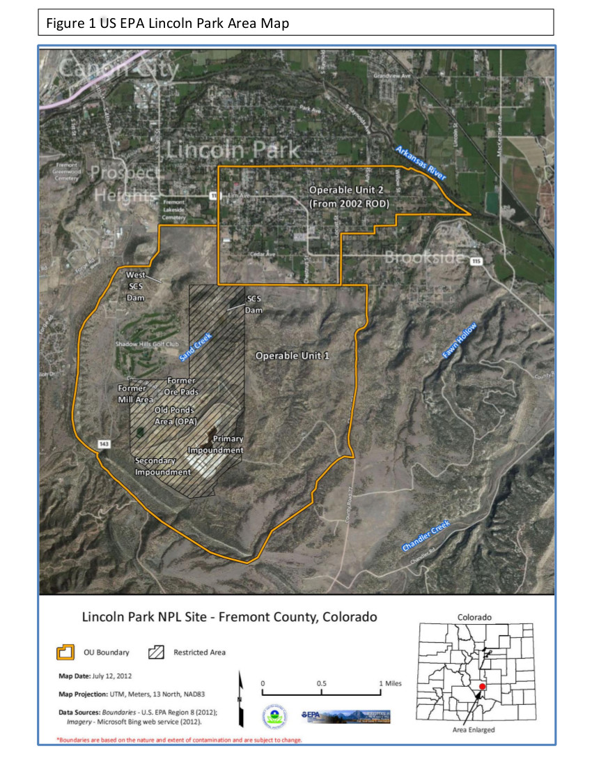
In February 2023, the current Radiation Materials License holder, Colorado Legacy Land (CLL), declared insolvency and stated they could no longer maintain staff to ensure site security or continue regular operations. The Department of Public Health and Environment (CDPHE) took emergency action and contracted with the existing company, Ensero Solutions LLC, to continue with the necessary on-site activities. CDPHE assumed the monitoring program including wells and air monitoring stations because CLL had abandoned these responsibilities.
At the end of February, the CDPHE sent a letter to residents of Lincoln Park who have been part of the well-monitoring program established decades ago to keep track of groundwater contamination associated with the former Cotter Uranium Mill. The agency was asked for permission to access properties and test wells as had been done routinely in the past by either Cotter or CLL.
At the Community Advisory Group (CAG) meeting on April 16, Shiya Wang, CDPHE Radiation Project Manager, announced that of the 38 letters sent to well owners, only 16 responses were received to allow CDPHE representatives to continue the monitoring program. If you, the well-owner, receive a follow-up letter, please take the time to complete your information and get it back to the CDPHE. Any questions can be directed to the agency or the CAG at its Facebook page, “Lincoln Park/Cotter Community Advisory Group”
The reason for monitoring, as stated in the letter, is: “Continuous sampling of environmental media provides valuable data to both the State and to the Lincoln Park Community regarding the migration of hazardous constituents in the environment that have been associated with historical operations at the Site. Residents are encouraged to continue providing access to the sampling location so that this information can continue to assist the State’s, as well as the community’s, understanding of the current conditions in the area.

Click the link to read the article on the Utah News-Dispatch website (Kyle Dunphey):
May 9, 2024
Law professors from around the country threw their support behind a lawsuit filed against the state of Utah, arguing officials haven’t done enough to help the Great Salt Lake.
In an amicus brief filed in Utah’s 3rd District Court last week, 36 law professors say Utah is violating public trust doctrine, which requires the state to protect cultural or natural resources for public use, including bodies of water, land, artifacts or wildlife.
It’s the latest in a lawsuit filed in September by Earthjustice, Utah Physicians for a Healthy Environment, American Bird Conservancy, Center for Biological Diversity, Sierra Club and Utah Rivers Council, all conservation groups.
Public trust doctrine was in place when Utah was granted statehood in 1896, according to the Utah Law Review, designed to ensure the state’s navigable waterways would be protected and available for public use. As the Utah Division of Forestry, Fire and State Lands noted in a 2023 presentation to lawmakers, “The beds of navigable bodies of water must be managed in a way that does not interfere with navigation, commerce, fishing, and the ecological value of the waterbody.”
The lawsuit notes that public trust doctrine is “well established” in Utah code and has been upheld by several state Supreme Court decisions. In the brief filed this week, the professors cited court rulings that found states have an obligation to preserve public resources.
“Consistent with this growing judicial chorus, Utah’s public trust duties are to protect and preserve the Great Salt Lake. Utah has not come close to meeting those responsibilities,” the brief reads.
In a statement given to Utah News Dispatch on Thursday, officials pushed back on that argument.
“We have been — and will continue to — work to protect the interests of the state of Utah. Each division within the Department of Natural Resources is mindful of its responsibilities. Together, we are addressing the need to protect the Great Salt Lake,” said Joel Ferry, executive director of the Utah Department of Natural Resources.
The lawsuit names several state agencies, including the Utah Department of Natural Resources, the Utah Division of Forestry, Fire and State Lands, and the Utah Division of Water Rights.
The state has filed motions to dismiss the lawsuit, writing earlier this year in court documents that “The legal solution offered by Plaintiffs is unsupported by Utah law and disregards the many and varied mechanisms the State is utilizing to manage Great Salt Lake.”
That sentiment was echoed in a social media post from Republicans in the Utah Legislature, which didn’t specifically reference the lawsuit, but criticized “litigious outside interests.”
“The Legislature’s progress on the Great Salt Lake has been nothing short of historic,” reads a post on X from the House Majority account. “To continue this work, we need real solutions — not symbolism and theatrics. We need local involvement, not litigious outside interests.”
The brief references several state actions it says endangered the public trust resources. That includes “actively authorizing water appropriations that divert upstream water.”
“Rather than address that problem, the state has instead focused on ‘trying to persuade individual water users to undertake voluntary measures to reduce their consumption,’” the professors write. “Seeking voluntary measures from water users is insufficient to meet the state’s duty to ensure against the ‘substantial impairment’ of the Great Salt Lake while the lake continues to shrink and its ecosystem is undergoing collapse,” the group of professors write, urging the court to force Utah to develop and enforce a plan to restore the lake.
That plan could include “changing surplus water management in wet years, managing flows outside the irrigation season for conservation, and requiring efficiency improvements with the conserved water released to the Lake,” according to court documents.
In a statement, Ferry said the department received and reviewed the brief, and plans to oppose it.
“It is largely duplicative of the Plaintiffs’ arguments and that Utah’s district court rules do not authorize such filings,” he said.
The brief was signed by law professors from around the country, including the Georgetown University Law Center, University of Baltimore School of Law, University of Oregon School of Law, and University of Houston. However, there were no Utah-based signatories.
An amicus brief is a court document usually filed by academics, businesses, subject-matter experts or trade associations who side with one party in a lawsuit. They typically present additional information, perspectives or precedent for the court to consider.

Click the link to read the article on the KUNC website (Alex Hager):
May 9, 2024
This story is part of ongoing coverage of the Colorado River, produced by KUNC in Colorado and supported by the Walton Family Foundation. KUNC is solely responsible for its editorial coverage.
The Colorado River is in trouble. More than two decades of megadrought fueled by climate change have sapped its supplies, and those who use the river’s water are struggling to rein in demand. Now, with current rules for river sharing set to expire in 2026, policymakers have a rare opportunity to rework how Western water is managed.
The river is shared across seven states and parts of Mexico. It’s an area that includes about 40 million people, a multibillion-dollar agriculture industry, 30 federally-recognized native tribes and countless plants and animals.
Satisfying the needs of such a diverse group is proving difficult, and the policymakers tasked with shaping the river’s next chapter are stuck at an impasse.
The federal government operates the massive dams and reservoirs that control the river’s flow, but has mostly left decisions about how to share its water to states.
Right now, the states are divided into two groups that have bickered about water management for the past century. One group, the Upper Basin, is comprised of Colorado, Utah, Wyoming and New Mexico. The other, the Lower Basin, includes California, Arizona and Nevada.
Those two camps have each sent proposals to the federal government in an attempt to have their say in shaping the river’s future. Those competing proposals, along with separate recommendations from environmental advocates and tribal groups, are making it hard to coalesce around one set of rules.

The Upper Basin proposal
The Upper Basin is legally required to send a certain amount of water to downstream neighbors each year. After more than 100 years of complying with that standard, Upper Basin states contend they should be allowed to send less. The Upper Basin’s proposal puts that idea into writing.
About 85% of the Colorado River starts as snow in the Upper Basin’s mountains. Climate change, the catalyst for the region’s water shortages, is shrinking the amount of snow that falls in those mountains each year.
Because of that, the Upper Basin states argue, the Upper Basin feels the sting of climate change more sharply than the Lower Basin. Cities and farms within its four states have to adjust their water use in accordance with recent snowfall, Upper Basin leaders say, but the Lower Basin can count on predictable water deliveries from upstream.
Sending less water downstream, however, would be a violation of the Colorado River Compact, the 1922 legal agreement that provides the framework for modern water management in the arid West.
The Upper Basin’s pitch to send less water relies on a specific interpretation of the language in that agreement — one that hasn’t been tested in court. Critics of the plan, particularly leaders in the Lower Basin, say that interpretation isn’t solid enough to be such a big part of Colorado River management going forward.

The Lower Basin proposal
The Lower Basin states released their own proposal for managing the Colorado River on the same day as their upstream neighbors.
Their proposal introduces a new way of measuring how much water is stored in the region’s reservoirs and a new system for figuring out water cutbacks accordingly.
Currently, decisions about when to cut back on water—and by how much—are calculated using forecasts about water levels in Lake Powell and Lake Mead, the nation’s two largest reservoirs. The Lower Basin wants to, instead, make those decisions based on the total amount of water held in eight reservoirs, including Powell and Mead.
Lower Basin leaders say their new system would be more holistic and sustainable than the current way of doing things.
Under the Lower Basin proposal, water cutbacks would be triggered when the combined amount of water in those eight reservoirs falls below a certain amount.
Cutbacks are split into three tiers. In the first two, when reservoir levels are somewhat low, Lower Basin states would be the only ones to take less water. But when combined reservoir levels drop below 38% full, both the Lower Basin and Upper Basin would have to take cuts.
Read more about the Upper and Lower Basin proposals here.
Environmental groups submit separate proposal
A coalition of environmental nonprofits sent another proposal to the federal government. Those recommendations aim to make sure enough water flows through rivers to sustain healthy ecosystems for plants and animals.
The proposal suggests a new system of measuring water and doling out cutbacks. Like the Lower Basin’s plan, it would measure water in eight reservoirs instead of two. As an added layer, the environmental groups also suggest using recent climate conditions — like the amount of water held in soils — as a factor when deciding how much water to release from reservoirs.
The environmental proposal also wants water managers to take fish habitats into greater consideration when deciding how much water should be released from reservoirs.

In addition, the conservation groups suggest more frequent releases of water into the Colorado River Delta, an area in Mexico where the river used to meet the ocean. Considered an important bird habitat, the Delta now only has water flowing through it when policymakers decide to send it there.
Lastly, the environmental proposal recommends the creation of a “conservation reserve,” a new program that would let water users leave extra water in reservoirs to help the environment and protect infrastructure like dams, both of which can suffer when water levels are too low.
All seven of the organizations that crafted the river management proposal receive funding from the Walton Family Foundation, which also supports KUNC’s Colorado River coverage.
Read more about the environmental proposal here.
Tribal groups advocate for water interests
Tribes, which have long been left out of conversations about managing water in areas they occupied long before white settlers, are also trying to shape the Colorado River’s future.
The 30 tribes that use Colorado River water are diverse and rarely agree on any one water management policy. Because of that, they sent the federal government a letter with a set of “principles” – broad reaching ideas about water management that don’t specify how much water might flow to individual states or tribes.
So far, 19 different tribes have co-signed the letter. In it, they call for three things that could give Indigenous people a bigger role in managing water:
First, they want the federal government to uphold a longstanding legal obligation to tribes by rejecting any new rules that could cut into their access to water and compensating any tribes that are forced to take cutbacks in times of shortage.
Tribes hold rights to about a quarter of the river’s flow, but many don’t have the funding and infrastructure to use all the water they’re allowed, and instead leave it in the river. In a second tenet, the letter asks the government to make it easier for tribes to take part in conservation programs – in which water users get paid to leave water in the river – and make it easier for tribes to market or lease their water to people who don’t live on tribal land.
Third, the letter asks the government to formalize tribes’ seats at the table. They have largely been left on the sidelines of water negotiations for the last century, and now they’re asking for a more set-in-stone way for tribes to have a say in talks about Colorado River policy.
Read more about the tribal letter here.
What’s next?
The federal government wants states to agree on one proposal, rather than two, before it installs any new Colorado River water rules. States say they’re working towards consensus, but signs of progress have been few and far between.
While the next set of rules won’t go into effect until 2026, the federal government wants to get the ball rolling as soon as possible. The Biden Administration is asking states to agree on one proposal before the end of 2024, in case the current administration loses the White House in the November election.
Without significant changes to the way the Colorado River is used, the problem is likely to get worse. Scientists predict that climate change will keep shrinking the water supply, meaning cutting back on demand will only get more important.


0 years ago April averaged ~402 ppm. Preliminary data: https://gml.noaa.gov/ccgg/trends/
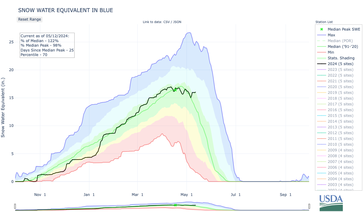
Click the link to read the article on the Summit Daily News website (Ryan Spencer). Here’s an excerpt:
May 11, 2024
Dillon Reservoir will “fill and spill” for the second year in a row, Denver Water announced this week. Dillon Reservoir – which is [part of] Denver’s public water supply – is currently 87% full, matching the average for May, according to Denver Water. Natural streamflow into the reservoir is predicted to be 101% of normal this runoff season and, right now, inflow into the reservoir is about 350 cubic feet per second. With the reservoir levels expected to reach an elevation of 9,012 feet by June 12, Denver Water said that it expects both the Dillon and Frisco marinas could be fully operational by that date. As inflows into the reservoir increase over the next week, Denver Water said it will ramp up outflow to the Blue River to between 200 and 400 cubic feet per second. Then, the following week, outflow may be adjusted to accommodate the Colorado Park and Wildlife’s fish survey and will likely remain in the 250 to 400 cubic feet per second range.
But by the end of May or early June, [Kevin] Foley said that he expects the Blue River will be open to commercial rafting, which requires at least 500 cubic feet per second. He expects the season could last three to four weeks, though it could be longer or shorter depending on weather. With a healthy snowpack peak of 119%, Foley said that the conditions for rafting could be pristine this summer. That is enough of a snowpack to fill the Dillon Reservoir and have other rivers in the state flowing too, but it is not so much that it will create too strong of streamflows for commercial rafting, he said.

Click the link to read the article on The Aspen Daily News website (Austin Corona). Here’s an excerpt:
May 10, 2024
Ruedi Reservoir is expected to hit full capacity for only the second time in five years, according to projections shared by reservoir managers. The managers don’t know exactly when the reservoir will hit capacity, though Tim Miller, hydrologist for the Bureau of Reclamation — the federal agency that operates Ruedi Dam — said it will likely stay full through July. Miller said calls for Ruedi water farther down the Colorado River could change that timeline. Ruedi is currently 68.8% full.
Ruedi did not reach its full capacity for three years between 2020 and 2022. Low runoff kept the reservoir from filling in 2020, and then overshoots in inflow projections and dry soils caused the reservoir to miss its capacity again in 2021. Reservoir levels then dropped to a 20-year nadir in March 2022 and never quite reached full capacity during a rebound that summer. Those three years were the only multiyear stretch in which Ruedi failed to fill in the last 10 years. Reservoir levels also fell short in 2018.
Ruedi ended its dry streak after a wet winter in 2023, with Miller reporting in August that last year was almost flawless for reservoir operations. This year, Miller said snowpack and runoff projections look similar to 2023. Water supply forecasts from the National Oceanic and Atmospheric Administration’s Colorado Basin River Forecast Center project a total Fryingpan River April-July runoff volume at Ruedi roughly 10% higher than projections from the same time in 2023 (this year’s May 1 projection is 135,000 acre feet).
Miller said the Ruedi may receive even greater flows than expected this year because of operational issues at a connected facility on the eastern slope. Miller said water managers may have to leave more water in the Fryingpan River this year than usual if Turquoise Lake, an eastern slope reservoir that receives Fryingpan water through a tunnel under the continental divide, fills up. Miller said Turquoise’s outflow will be limited this year because both pump/turbine units at the Mount Elbert pumped-storage powerplant, which constitutes one outlet for the reservoir, are not operating this summer.

Click the link to read the article on The Durango Herald website (Reuben M. Schafir). Here’s an excerpt:
Sen. Michael Bennet and U.S. Bureau of Reclamation Commissioner Camille Calimlim Touton visited the Pine River Indian Irrigation Project on Monday and announced $147.6 million in investments to 42 projects in 10 states facing water reliability challenges. The announcement included a $2.3 million grant to the Southern Ute Indian Tribe to address the PRIIP’s crumbling infrastructure. The funding is a part of the Bureau of Reclamation’s Watersmart Drought Resiliency program.
“For too long, the United States has failed to live up to its responsibility to adequately fund and maintain the Pine River Indian Irrigation Project,” Bennet said in a news release. “I was grateful to travel to Ignacio (Monday) with Commissioner Touton to welcome this investment to ensure the Southern Ute Indian Tribe can access the water it needs. There is much more work to be done, but this is a great start.”
The project uses water from Vallecito Reservoir, managed by the Pine River Irrigation District, to irrigate about 12,000 acres of land via 170 miles of ditches and raised flumes. Tribal officials have called the degradation of the infrastructure a “ticking time bomb,” and farmers and rancher dependent on the system are routinely shorted the water they need. According to a 2024 estimate reported by the Colorado Sun, PRIIP needs $35.3 million in repairs.
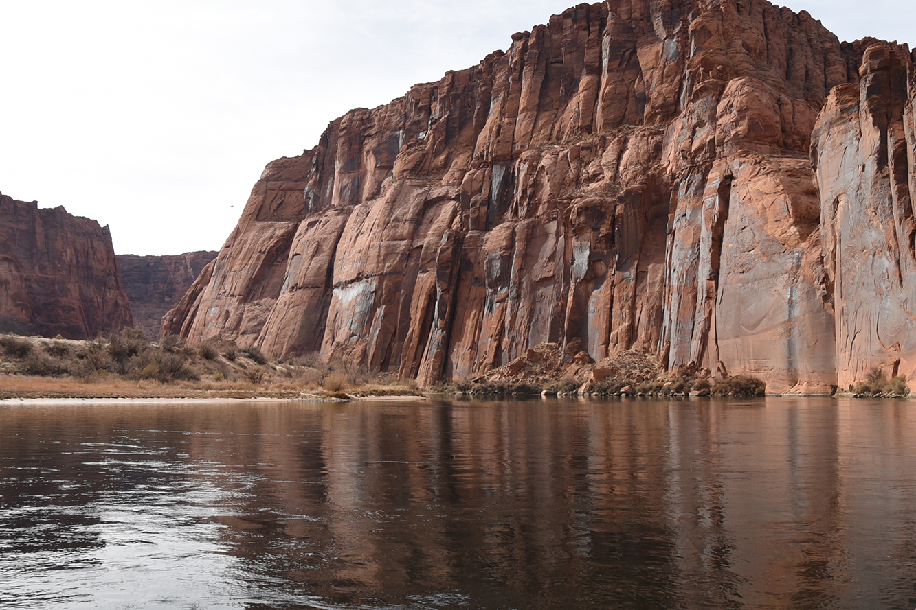
Click the link to read the article on the Reclamation website:
May 9, 2024
Interior Department announced earlier this year that historic investments led to record water savings, helped stave off immediate collapse of Colorado River system
WASHINGTON – The Bureau of Reclamation today finalized its process to protect the short-term stability and sustainability of the Colorado River System by signing the Supplemental Environmental Impact Statement (SEIS) for Near-term Colorado River Operations Record of Decision. The Department of the Interior released the final SEIS in March 2024.
Reclamation initiated the supplemental environmental impact statement to protect Glen Canyon Dam and Hoover Dam operations, system integrity, and public health and safety. This supplemental guidance will be effective through 2026 – at which point the existing 2007 Interim Guidelines and the 2019 Drought Contingency Plans expire. This record of decision is a substantial milestone in the ongoing efforts to address water scarcity, the ongoing drought, and climate change challenges in the Colorado River Basin.
Reclamation’s action selected in this record of decision is the preferred alternative that the Department identified in March 2024, which will yield at least 3 million acre-feet of system water conservation savings through the end of 2026, coinciding with the expiration of the current guidelines, and provides additional tools to manage dry hydrology. Selection of the preferred alternative was made possible through Reclamation’s collaborative efforts including those with the seven basin states, 30 basin Tribes, water managers, farmers and irrigators, municipalities, power contractors, non-governmental organizations, and other partners and stakeholders, and underpinned by historic water conservation enabled by President Biden’s Investing in America agenda.
President Biden’s Investing in America agenda is integral to the efforts to increase near-term water conservation, build long term system efficiency, and prevent the Colorado River System’s reservoirs from falling to critically low elevations which would threaten water deliveries and power production. Through the Bipartisan Infrastructure Law, Reclamation is investing another $8.3 billion over five years for water infrastructure projects, including water purification and reuse, water storage and conveyance, desalination and dam safety. Since the Law’s signing, the Department has provided more than $2.9 billion to fund 425 projects, including $825 million for 131 aging infrastructure projects; $377 million to 231 WaterSMART grants; $382 million for 12 water storage and conveyance projects; and $698 million to seven rural water projects. The Inflation Reduction Act also provides $4.6 billion to address the historic drought across the West – including for system conservation agreements throughout the Colorado River Basin.
As described in the previously announced final SEIS, key information in today’s record of decision includes:
- System Water Conservation: The preferred alternative will conserve at least 3 million acre-feet of system water through 2026. The results of the supplemental environmental impact statement modeling indicate that the risk of reaching critical elevations at Lake Powell and Lake Mead has been reduced substantially.
- Lake Powell Releases: The preferred alternative allows for reducing annual releases from Lake Powell to 6 million acre-feet if the reservoir is projected to fall below 3,500 feet over the subsequent 12 months. This adaptive approach ensures the long-term integrity of the system.
- Complementary Measures: The preferred alternative builds upon the existing 2007 Interim Guidelines, incorporating additional strategies to mitigate shortages and contributions under the 2019 Drought Contingency Plans.
The short-term supplemental environmental impact statement process is separate from the ongoing long-term efforts to protect the Colorado River Basin after current guidelines expire in 2026. The post-2026 process currently underway is working to develop new guidelines that will replace several reservoir and water management decisional documents and agreements that govern the operation of Colorado River facilities and management of the Colorado River that are scheduled to expire at the end of 2026.

Click the link to read the article on the Water Education Colorado website (Jerd Smith):
May 9, 2024
Thousands of acres of Colorado wetlands and miles of streams, left unprotected by a U.S. Supreme Court decision last year, would be shielded under a hard-won measure that was approved this week by a bipartisan group of state lawmakers.
Environmental advocates say Colorado leads the nation in adopting such regulations, which will replace certain Clean Water Act rules that were wiped out last year in the U.S. Supreme Court case Sackett v. EPA.
“Colorado is the first state to pass legislation on this issue,” said Josh Kuhn, senior water campaign manager for Conservation Colorado. “It had a lot of attention because of the magnitude of the bill. There were dozens and dozens of meetings to try and strike the right balance. We’re really happy with this final piece of legislation.”
The Sackett case sharply limited the streams and wetlands that qualify for protection under the Clean Water Act, a decision that water observers said had a particularly broad impact in the West. In Colorado and other Western states, vast numbers of streams are temporary, or ephemeral, flowing only after major rainstorms and during spring runoff season, when the mountain snow melts. The Sackett decision said, in part, that only streams that flow year-round are subject to oversight. It also said that only wetlands that had a surface connection to continually flowing water bodies qualified for protection. Many wetlands in Colorado have a sub-surface connection to streams, rather than one that can be observed above ground.
The legal decision came after decades of federal court battles over murky definitions about which waterways fall under the Clean Water Act’s jurisdiction, which wetlands must be regulated, what kinds of dredge-and-fill work in waterways should be permitted, what authority the act has over activities on farms and Western irrigation ditches, and what activities industry and wastewater treatment plants must seek permits for.
With the passage of House Bill HB24-1379, which passed Monday, Colorado wetlands are once again formally protected, as are ephemeral streams, said Kuhn.
“It also sets the federal regulations as the floor, not the ceiling, so that Colorado can go above and beyond those to ensure we are protecting our resources,” Kuhn said.
House Bill 1379, sponsored by House Speaker Julie McCluskie, D-Dillon, Rep. Karen McCormick, D-Longmont, and Sen. Dylan Roberts, D-Frisco, was one of two proposed bills that sought to address the regulatory gap created by the Sackett decision. Senate Bill 127, sponsored by Sen. Barbara Kirkmeyer, R-Brighton, was the second.
While Senate Bill 127 ultimately was not approved, a number of exemptions it contained to address concerns of farmers, miners, developers and some cities, were eventually added to House Bill 1379 and Kirkmeyer signed onto the measure as well, becoming a Senate sponsor along with Roberts.
Those exemptions were important to gathering the support of farm and real estate interests, among others, according to John Kolanz, an attorney who represents developers and who served in a state workgroup that helped lay the groundwork for the new regulations.
“There was significant movement from the first draft to the end. Barb’s bill played a big role in that. This is an important program that touches a lot of people, and interests and activities. I think the end result is pretty good,” Kolanz said.
Among the exemptions that were added is a rule that specifically exempts maintenance work on irrigation ditches and canals. Another exempts work that disturbs less than one-tenth of an acre of wetland or 3/100th of an acre of a streambed.
“If you’re a developer … and you’re under those thresholds, you don’t need a permit, you just need to follow best management practices,” said Kuhn, who was among the negotiators who hammered out the details of the final legislation.
In addition, if a pipeline is installed or a ditch is lined, that activity is exempted if it can result in water conservation.
House Bill 1379 also gives regulators the option to add one staff person on the Western Slope to help with program administration in that region, and provides nearly $750,000 in the state 2024-25 fiscal year budget and nearly $250,000 in the next year to get the new regulatory program, housed within the Colorado Department of Public Health and Environment, up and running.
Senate Bill 127 had proposed housing the program within the Colorado Department of Natural Resources, due to concerns about an existing backlog in the CDPHE’s wastewater discharge program.
With the decision to house the program in CDPHE come requirements that require frequent reporting to lawmakers to ensure that health officials have the resources they need to review and issue permits, Kuhn said.
The Water Quality Control Commission will have until Dec. 31, 2025 to finalize the rules implementing the new law.
The bill is awaiting the governor’s signature.
“In Colorado, where the rivers and streams are the lifeblood of our land, our agriculture, and our communities, the importance of water cannot be overstated,” Kirkmeyer said in a text message. “I believe that House Bill 1379 will be the strongest protection for Colorado streams and wetlands that we have had in the last 50 years.”
More by Jerd SmithJerd Smith is editor of Fresh Water News. She can be reached at 720-398-6474, via email at jerd@wateredco.org or @jerd_smith.
Click the link to read the article on the ENSO blog (NOAA) website (Emily Becker):
May 9, 2024
El Niño weakened substantially over the past month, and we think a transition to neutral conditions is imminent. There’s a 69% chance that La Niña will develop by July–September (and nearly 50-50 odds by June-August). Let’s kick off the ENSO Blog’s tin anniversary with our 121st ENSO outlook update!
Attention!
First things first: our beloved editor, Rebecca Lindsey, has trained us all very well, including being sure to acquaint our newer readers with the fundamentals of the El Niño/Southern Oscillation climate pattern, or ENSO. ENSO has two opposite phases, La Niña and El Niño, which change the ocean and atmospheric circulation in the tropics. Those changes start in the Pacific Ocean and affect global climate in known ways. El Niño and La Niña can be predicted many months in advance, giving us an early picture of potential upcoming temperature, rain, and snow patterns. When neither El Niño nor La Niña are present and conditions are more normal across the tropical Pacific, well, that’s ENSO-neutral conditions.
Hang 10
There was some discussion this week amongst our ENSO forecast team about whether El Niño, much weakened already early last month, is still present. El Niño is a coupled system, meaning the ocean and atmosphere both exhibit characteristic changes. The atmospheric half of El Niño is harder to detect this month; most of the standard equatorial Pacific atmospheric indicators (rain and clouds over the tropical Pacific, trade winds and upper-level winds) were pretty close to average.
However, the April average sea surface temperature in the tropical Pacific was still 0.8 °C above average according to the ERSSTv5 dataset (average = 1991–2020). The latest weekly measurement, which comes from the OISSTv2 dataset, was 0.5 °C above average. Given that the El Niño threshold is 0.5 °C, the team decided we’re right on the edge of the transition to neutral conditions. We also can’t rule out some lingering El Niño impacts in other regions of the world.

Once this El Niño ends, it’s likely that our spell of neutral conditions won’t be a long one, with La Niña expected to develop by the late summer and last through the early winter at least.

We’ve seen a quick switch from El Niño to La Niña several times before in our 1950–present record, especially after a strong El Niño. This tendency is one source of confidence in the prediction that La Niña will develop later this year.
Other factors that provide confidence that La Niña is on the way include forecasts from computer climate models and cooler-than-average water under the surface of the tropical Pacific.
10-count
Even if the sea surface temperature in the tropical Pacific lingers near the El Niño threshold for a few weeks, it’s unlikely that there will be noticeable El Niño impacts on global climate conditions this coming summer. Nat looked at how the winter turned out in the US in his recent post, but El Niño causes changes in rain and temperature patterns all around the world, with related impacts on drought, food supplies, and flooding. You can look at El Niño and La Niña’s global patterns of temperature and rain/snow throughout the seasons here.
To get some insight into how this past winter turned out in other regions, I checked in with Steven Fuhrman of NOAA Climate Prediction Center’s International Desk (footnote). Steven had this to say about the effects from El Niño since December:

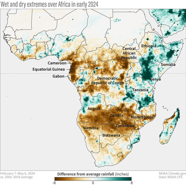
While many El Niño-related shifts in temperature and rain/snow are strongest during the Northern Hemisphere winter (December–February), some start earlier and last longer, especially in the tropics. One example is a tendency for drier and warmer conditions in central America and northern South America from September through March or April. Rebecca wrote about the impacts on the Amazon Rainforest back in the fall. Steven added this recap:

El Niño’s and La Niña’s shifts in temperature and rain impact communities around the world, including affecting global health and crop yields. This is why we spend so much time studying and predicting ENSO—it can provide an early heads-up of the possibility of severe impacts and allow people time to prepare.
Double digits
Speaking of so much time—who would have thought when we launched this blog back in May 2014 that we’d still have so much to say, 10 years later? In upcoming months, we’ll keep you posted on the ENSO forecast and discuss some of the climate shifts that can be expected during La Niña, including the likelihood of an active Atlantic hurricane season and drier winter conditions through the Southwest U.S. Also, I just checked our “ENSO Blog ideas” doc, which currently runs five pages long, so… here’s to another 10??
Footnote
Fun fact: For many years, Steven and I have regularly donated blood at our local hospital, along with some of our friends. There’s a national blood shortage in the U.S. right now—please consider visiting your local blood donor center!
22% of the Lower 48 is short/very short; 3% less than last week. Much of the US improved last week. Conditions declined in some states along the East Coast. Already dry soils dried out further in NM & CO.
Click the link to read the article on the Colorado Climate Center blog (Russ Schumacher):
May 8, 2024
As we’ve covered in previous posts, the peak snowpack in Colorado’s mountains generally looked pretty decent this year, with the amount of water stored in the snow peaking pretty close to the long-term average in most areas. However, in the southern mountains, it’s been another year where the melt has happened a lot faster than it typically has in the past.
As of early April (left image above), all basins in Colorado had above average snow water equivalent, as measured by the SNOTEL network. But a month later (right image), the picture is quite different. The northern basins still look good, with a string of April snowstorms adding to the snowpack there. But southern Colorado largely missed those storms, and warm, sunny conditions, assisted by layers of dust on snow, really accelerated the melt. Cooler conditions this week will slow down the melt a bit, and a storm this weekend will add some much-needed moisture. But once the snow itself gets warmer than 32°F, it’s hard to slow the melt too much. The Rio Grande basin now only has half of the snowpack it typically does on May 6.
The time series graph for the combined San Miguel, Dolores, Animas, and San Juan river basins in the southwest corner of Colorado illustrates this nicely:
The trace for 2024 reached essentially an average peak, and right on time: the peak was 18.1″ of SWE on April 2, compared to an average peak of 18.6″ on April 1. It also stayed near that peak for about another 10 days, but then the melting progressed extremely quickly. In fact, it was the largest 14-day loss of SWE before the end of April in this basin since the start of SNOTEL data in the 1980s.
Before going into those numbers, a quick note on snowpack melt rates. In absolute terms, the fastest melts come in years when there are big snowpacks that linger late into May or early June, like 2019. Eventually that snow can’t stand up to the summer sun, and SWE goes away at a very fast rate. But in years like 2024, what we’re interested in is the snow melting quickly, and early.
So here, we’ll look at the largest two-week declines in SWE prior to the end of April, and we see that the combined southwest river basins lost over 8″ of snowpack from April 12-26 this year. That much melt so early hasn’t been observed before. The Upper Rio Grande and Arkansas basins also saw their largest 14-day SWE declines prior to April 30.

If you look on the bright side, you can’t get rapid melts like this without a good snowpack to begin with. At least, unlike some really bad drought years, the water was there in the first place! But early melts have big implications for the timing of water availability. It means higher-than-normal streamflows in May, but then much lower streamflows later during the heat of summer, when the water is really needed, especially by those who don’t have access to water stored in reservoirs. And the overall water availability situation for this spring and summer isn’t looking great in southern Colorado, with the latest CBRFC forecast projecting only 90% of average flow into Blue Mesa Reservoir, 74% of average on the Animas, and 80% of average into Lake Powell.
And unfortunately, years like this have been getting more common, and that trend is expected to continue as the climate warms. These changes are addressed in detail in the water chapter of Climate Change in Colorado, so dive in to that for more details. But in general, the changes observed up to this point have been toward modest declines in peak snowpack, but robust trends toward earlier melting, and these changes have been most acute in southern Colorado. For the future, there is still considerable uncertainty about what will happen to winter precipitation: some climate projections show more winter snow, others less. But every one of them shows a shift toward earlier snowmelt, and earlier peak streamflow on the Colorado River, meaning changes to when and where our water supply is available. In other words, we might need to get used to the snowpack looking pretty good in the southern mountains in March, but being disappointed in the numbers when May comes around.

Click the link to read the article on the Sky-Hi News website (Emily Guitierrez). Here’s an excerpt:
May 7, 2024
Grand County and Northern Colorado Water Conservancy District, otherwise known as Northern Water, have agreed to work together on an operational framework that will give Grand County’s waterways as much as 7,000 acre-feet of additional controllable water from the Colorado-Big Thompson Project for stream enhancement. The volume available for streamflow improvement will be dependent on annual river conditions and C-BT Project storage levels. The agreement was approved by the Grand County Commissioners on April 23.
Water made available under this agreement to the county will be released to the Willow Creek Reservoir or the Colorado River. This water will supplement existing flows and could accumulate to nearly 40,000 acre-feet over the course of a decade, according to a joint news release from Grand County and Northern Water…Prior to 2005, this water was used for irrigation of hay fields near the town of Granby. However, the lands have since been converted for residential and commercial development. This additional water will benefit Grand County’s recreation and agriculture industries.
Click the link to read the article on the Water Education Colorado website (Patty Rettig):
May 7, 2024
After trekking on skis up a mountain, two men unpack equipment, use a long metal tube to take a snow sample, weigh it, and record the measurement. Captured on 16mm film in the mid-twentieth century, the men demonstrate the most advanced snow survey techniques of their time, providing us a fascinating glimpse into the past.
Three such films—one of which is undated, with the others being from about 1941 and 1952 (narrated and in color!)—held by the Colorado State University Water Resources Archive, when considered with related photographs, reports, data, and letters, reveal an important part of the story of the development of snow surveying and water supply forecasting in the western United States.
Federal coordination of snow surveying began in the 1930s, after several decades of individual states and institutions independently taking measurements. Though Nevada and Utah are recognized as the pioneering states, in 1902 Colorado’s state engineer hired Enos Mills as the state’s first snow surveyor. Several of his 1903 and 1904 letters in CSU’s Agricultural and Natural Resources Archive provide insight into how monitoring snowpack started here.

By the mid-1930s, following the drought of the early part of the decade, interest grew in having water supply predictions. The U.S. Department of Agriculture took on snow surveying and water forecasting not only to benefit irrigators who relied on the forthcoming snowmelt, but also to support the economic interests of industry and hydropower as well as predict stream flooding.
In Colorado, Ralph Parshall, as senior irrigation engineer at the USDA branch in Fort Collins (and best known for the Parshall flume), contributed to the emerging Federal-State Cooperative Snow Surveys in a number of ways. Parshall’s materials in both his archival collection and his team’s files document his active participation over more than a decade. These include letters and drafts related to several Colorado River Water Forecast Committee meetings, including the first, held in 1945 and at which Parshall presided. A published draft of those proceedings can be found in the Water Resources Archive’s Groundwater Data Collection.
Also among Parshall’s materials, a few dozen photographs of snow courses and related images also exist, some of which remain to be digitized. Additional photographic materials in other collections include slides showing Parshall and others conducting snow surveys at Cameron Pass and in Rocky Mountain National Park, as well as a set of about 100 images (not digitized) taken during winter and spring months at McNey Hill in northern Colorado. This set reveals a decade-long photography project involving both Ralph Parshall and his son Max.
A collection from the Colorado Snow Survey Program of the Natural Resources Conservation Service contains two boxes of photographic materials. These images show snow survey sites and equipment, agency employees, and public outreach events. Two of the films referenced above also are in this collection. The NRCS, having evolved from the USDA division that Ralph Parshall was part of, began operating the first SNOTEL (SNOpack TELemetry) site in 1977. This automated system of collecting snow and weather data greatly furthered the field, especially for remote sites where access is difficult.

The science, methods, and equipment related to measuring snowpack and estimating water content have continued to evolve. In the Water Resources Archive, documentation of snow hydrology studies as well as aerial snowpack measurement is also available for research.
Additional collections in the Water Resources Archive also touch in part on snow surveying and can be found through browsing our research guide. All of our materials are available for use by the public, and assistance can be provided in person at CSU’s Morgan Library or remotely.
Patty Rettig is the archivist for the Water Resources Archive at the Colorado State University Libraries. Over more than 20 years, Rettig has built the archive to hold over 130 distinct collections documenting Colorado’s water heritage by engaging with the water community across the state. She is happy to help anyone dive in to archival research!

Click the link to read the article on the Colorado Times-Recorder website (David O. Williams):
May 7, 2024
For state Sen. Dylan Roberts (D-Frisco) “protecting and securing our water future is the most important issue and biggest challenge facing our state for the next several decades.”
So as the current legislative session circles the proverbial drain, he’s been pushing hard to secure funding for water projects, enact the recommendations of the Colorado River Drought Task Force, and, perhaps most critically, replace wetlands protections stripped away by the Trump-stacked U.S. Supreme Court in last year’s highly controversial Sackett v. EPA decision.
That ruling, which backed an Idaho couple who didn’t want to get a U.S. Army Corps of Engineers wetlands dredging permit, gutted decades of federal Clean Water Act protections for fully two-thirds of Colorado’s vital wetlands and streams, according to Colorado Attorney General Phil Weiser’s brief filed in support of those protections.
Colorado lawmakers this session stepped into that regulatory void with two competing bills – a rarity in the Colorado Legislature, according to Roberts. The Regulate Dredge and Fill Activities in State Waters bill (HB24-1379), sponsored in the House by Speaker Julie McCluskie (D-Dillon) requires a rulemaking by the Colorado Department of Health and Environment’s Water Quality and Control Division to permit dredge and fill activities on both public and private land.
The competing bill (SB24-127) from Republican state Sen. Barb Kirkmeyer (R-Brighton) known as the Regulate Dredged & Fill Material State Waters bill, was backed by the Colorado Association of Homebuilders. Environmental groups and some Democrats said the Kirkmeyer bill fell short of replacing longstanding federal protections for wetlands for several reasons.
“We reached an agreement with Sen. Kirkmeyer and some of the folks that she was working with on her bill,” Roberts said in a phone interview. “She is going to join me as the co-prime sponsor on the bill with the Speaker and let her Senate bill go. So, we’ve gotten to a really good place … We just made a few final amendments that got Kirkmeyer on board, but the environmental advocates are very pleased with where we stand.”
On Monday, the full Senate passed the new version of HB24-1379 and sent it back to the House, which then repassed it after considering amendments.
“We could not be more proud of the fact that Colorado is the first state in the nation to pass legislation that restores protections to our wetlands and streams that were overturned by Trump’s Supreme Court,” Conservation Colorado’s Senior Water Campaign Manager Josh Kuhn wrote in an email. “Our coalition and the bill sponsors worked to negotiate several significant compromises that led to the legislation we see today, and it remains a win for the environment.” Proponents hope the Colorado bill will become a national model.
Two of Kuhn’s biggest criticisms of the original Kirkmeyer bill was its “political line” saying waters outside of 1,500 feet from the historical floodplain would be unprotected, and its regulatory structure requiring a new agency in the state’s Department of Natural Resources.
“That’s not in our House bill,” Roberts said. “Our House bill is much more based on the actual wetland and the connection to Colorado waters and basically what the Army Corps was doing. So, the arbitrary line in the Kirkmeyer bill was a huge problem, and that is certainly not in the House bill. And it’ll stay with CDPHE, the Water Quality Control Commission.”
Asked if there was a concerted development industry effort to muddy the waters with the competing bill filed before the Speaker’s House bill, Roberts had this to say:
“It was an interesting tactic,” he said. “A lot of state legislatures, and obviously Congress does this, where there are similar bills that start in opposite chambers and they kind of compete with each other. That doesn’t normally happen here, but it was kind of interesting to have it play out that way this year.”

Roberts is also a bipartisan co-prime Senate sponsor with Sen. Cleave Simpson 9R-Alamosa) of a bill (HB24-1436) –Sports Betting Tax Revenue Voter Approval – that refers to a ballot measure asking voters in November if the state can spend additional sports betting tax revenue (above the current $29 million annual cap) on water-conservation projects. The bill passed out of both chambers and now heads to the desk of Gov. Jared Polis for his signature.
First established by voter approval of Proposition DD in 2019, the Water Plan Implementation Cash Fund goes toward water storage and supply, agricultural projects, and watershed health and recreation projects.“If we don’t [pass HB24-1436], we’ll have to refund the excess to the casinos,” Roberts said. “So I hope it’s a really easy question for voters, and that they would prefer the money go to water rather than back to the casinos.”
Roberts was also the sponsor of the annual water projects bill, which allocates $56 million to the Colorado Water Plan and various water infrastructure projects. More than half of that money currently comes from sports betting, and this year $20 million of it will go toward acquiring the Shoshone power plant water right from Xcel Energy to keep that non-consumptive right on the Western Slope for farmers, boaters, and aquatic life along the endangered Colorado River.
Finally, Roberts was co-prime Senate sponsor, along with Sen. Perry Will, R-New Castle, of SB24-197 (Water Conservation Measures) that implements several key recommendations of the Colorado River Drought Task Force, including the ability to loan water to an instream flow loan program for stream health and restoration, as well as protections for agricultural water.
The bill, which has cleared both the Senate and the House, will also allow power companies near the Yampa River in Northwest Colorado to temporarily loan their water to the river while they explore different types of energy development in a post-coal world, as well as enhance the ability of Colorado’s native tribes to get more funding for water projects using historic water rights.


Click the link to read the article on the Pagosa Springs Sun website (Randi Pierce). Here’s an excerpt:
Ons Thursday, May 2, 2024 sixth- graders in Terri Lindstrom’s Pirate Time advisory class rolled a cooler down to Town Park, then carried it to the edge of the river. There, the students used river water to acclimate the temperature of the water in the cooler — the transport for 75 rainbow trout fin- gerlings who were being taken to be released in the San Juan River.
As they waited for the fish to acclimate, the students read messages they wrote after spending the school year helping and watching the fish grow.
Lindstrom’s class raised and released the fingerlings through a partnership with the Trout in the Classroom program and Trout Unlimited…
“The purpose of the program is to give students the opportunity to ex- plore water quality,” Lindstrom wrote, explaining the students kept track of the water temperature, count and weight of the fish.
Four to five fish were pulled from the tank each week and weighed be- fore being returned, she notes. That allowed students to calculate the average weight per fish, which then allowed them to calculate 2 percent body weight of all the fish in order to know how much to feed them.

Click the link to read the article on The Land Desk website (Jonathan P. Thompson):
May 7, 2024
🤯 Annals of Inanity 🤡
INANE ACT: Utah State Rep. and gubernatorial candidate Phil Lyman and Lynn Jackson, a candidate for Lyman’s seat in the legislature, turn a protest of the proposed closure of Arch Canyon to motorized vehicles and ban on target shooting within Bear’s Ears National Monument into a grievance and victimhood campaign rally and a lot of whining about “federal overreach.”
CONTEXT: Bears Ears National Monument is rightly named after the two Wingate-sandstone capped buttes that rise up from the middle of the 1.3-million-acre swath of public land in southeastern Utah. Yet if I were to pick a heart of the monument, I’d be more likely to lean toward Arch Canyon, which starts on Elk Ridge near the buttes and slices a deep, 12-mile-long gorge through Cedar Mesa before joining up with Comb Wash under a grove of tall cottonwoods. My family and I used to camp under those trees when I was a kid, and we’d hike up the canyon, following the perennial stream that was alive with flannelmouth suckers, tadpoles, and water striders, gazing up at cliff dwellings nestled in tiny alcoves high up on the sheer, desert varnish-streaked cliffs.
Back then cattle were allowed to graze in the canyon, trampling the stream banks and taking refuge in — and pooping on — an Ancestral Puebloan site near the canyon’s mouth. Thankfully, a hard fought legal battle eventually got the cattle removed from Arch Canyon and a few other nearby canyons. But there is also a road up the canyon bottom, and on those long-ago hikes we’d occasionally encounter a jeep or Land Cruiser. The road remains, allowing OHVs to roar eight miles up the canyon, crossing the creek multiple times in the process.
The draft Bears Ears National Monument management plan proposes closing Arch Canyon to motorized vehicles to protect the riparian corridor and the natural and cultural sites there, and because it just makes sense to do so. It’s the only significant motorized closure under the plan’s preferred alternative, meaning about 800,000 acres would remain open to motorized travel on designated routes. The plan would also ban target shooting throughout the monument. There would be almost no changes to the existing grazing regime.
Basically, land managers and the Bears Ears Commission are looking to close an eight-mile dead-end road to protect a spectacular canyon, one of the area’s only perennial streams, and imperiled native fish, while leaving hundreds of miles of other roads and trails open to OHVs. And they want to nix recreational shooting to prevent people from shooting up landforms and petroglyphs — hunting will still be allowed.
It doesn’t seem like a lot to ask. Yet for this, the likes of Lyman and Jackson are skewering these land protectors as “overlords,” and are urging their followers to band together because they are “going up against a monster. … You have to fight back, you have to have the stomach to fight back.” Jackson added: “You can’t compromise.”
Not only is this Trump-esque rhetoric dangerous, but it’s also inaccurate. It willfully ignores the fact that the proposed management plan is itself a deep compromise, leaving out many of the protections Indigenous and environmental advocates want. In fact, the preferred alternative is remarkably unrestrictive and, some would say, miserably fails in its mission to protect this special landscape.
But admitting that land managers are far from overlords, and instead are bending over backwards to appease even the uncompromising likes of Lyman and Jackson, wouldn’t fit with Lyman’s preferred narrative of grievance and victimhood. Nor would it rile up his similarly minded base. And in the end this new breed of Republicans is far more interested in riling than in governing; in inciting anger and obstruction rather than in seeking solutions.
The arrogance of the off-road vehicle lobby — Jonathan P. Thompson January 2, 2024
In a rather predictable — but still maddening — move, the off-road-vehicle lobby is suing the Bureau of Land Management over the agency’s Labyrinth Canyon and Gemini Bridges travel plan for off-highway vehicle use. The BlueRibbon Coaltion, Colorado Off-Road Trail Defenders, and Patrick McKay are challenging…
🥵 Aridification Watch 🐫
Could global heating actually increase precipitation in the Colorado River Basin? Perhaps, according to a new study out of the University of Colorado, and a forecasted uptick in snow and rain should partially offset the effects of warming temperatures on river flows. The researchers say that’s because “precipitation has, and will likely continue to be, the main driver of the river flow at Lee Ferry.”
“We find it is more likely than not that Lee Ferry flows will be greater during 2026-2050 than since 2000 as a consequence of a more favorable precipitation cycle,” said Martin Hoerling, the paper’s lead author, in a press release. “This will compensate the negative effects of more warming in the near term.”
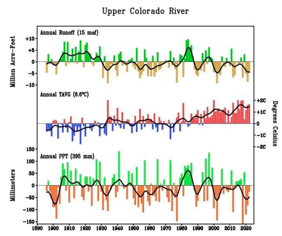
This relatively rosy finding is based on a suite of climate models, including ones from the International Panel on Climate Change, that forecast a 70% chance of increased precipitation in the Upper Colorado Basin in coming decades. But water managers probably shouldn’t abandon efforts to cut consumption on the River just yet: 70% isn’t exactly a sure thing; the researchers acknowledge that there’s also a chance that precipitation could stay as miserably low as it has been for the past two decades, or even decline.
And Brad Udall, a CU climate scientist who was not involved in the study, told KUNC’s Alex Hager that he has a bit of “unease” regarding the projections, adding that modeling future precipitation is filled with uncertainty. Temperature modeling, meanwhile, uses different methods and is therefore more reliable: It’s going to keep getting warmer.
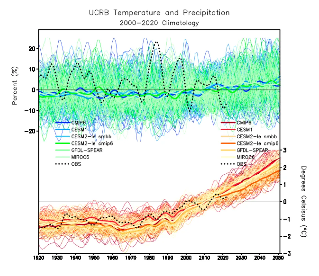
And those higher temperatures can erase some of the gains from higher precipitation levels, as this winter and spring demonstrated. Even though there was a normal amount of snowfall in many places, this spring’s runoff is expected to be below normal thanks to a rapid snowmelt.
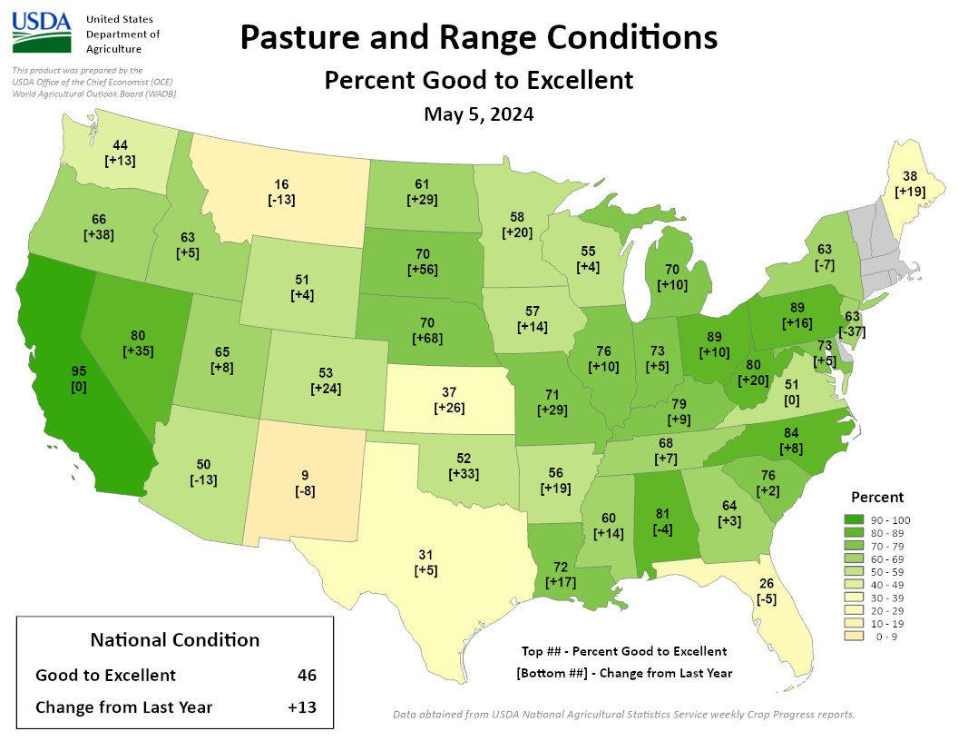
But – holy buckets – we’ve seen some significant improvement in pasture conditions vs. where we were one year ago.
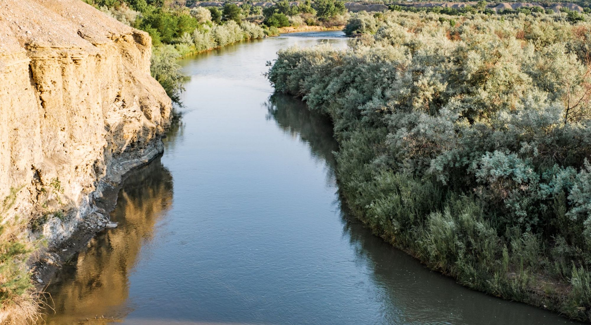
From email from Reclamation (Susan Novak Behery):
As the forecast weather warms up again and tributary flows are forecast to increase, the Bureau of Reclamation has scheduled a decrease in the release from Navajo Dam from 500 cubic feet per second (cfs) back down to 350 cfs for Monday, May 13th, at 4:00 AM.
Releases are made for the authorized purposes of the Navajo Unit, and to attempt to maintain a target base flow through the endangered fish critical habitat reach of the San Juan River (Farmington to Lake Powell). The San Juan River Basin Recovery Implementation Program recommends a target base flow of between 500 cfs and 1,000 cfs through the critical habitat area. The target base flow is calculated as the weekly average of gaged flows throughout the critical habitat area from Farmington to Lake Powell.
Click the link to read the briefing on the Western Water Assessment website:
May 9, 2024 – CO, UT, WY
The region experienced generally below normal precipitation and above normal temperatures in April. May 1st snow-water equivalent (SWE) was near-normal in Colorado (92%) and Utah (103%) and slightly below normal in Wyoming (88%). Seasonal streamflow volume forecasts are mostly below to near-normal in the region with above normal forecasts in northern Utah. Regional drought conditions improved and cover 10% of the region. El Niño conditions are transitioning to neutral-ENSO conditions and there is an 83% chance of neutral-ENSO conditions for May-July. The NOAA seasonal temperature outlook for May-July suggests an increased probability of above normal temperatures for the majority of the region.
April precipitation was generally below normal across the region with large swathes of above normal precipitation in northern Utah around the Great Salt Lake, north and south-central Wyoming, and from the Front Range to northeastern Colorado. Areas of less than 25% of normal precipitation occurred in southeastern Utah and southeastern Colorado with small pockets of less than 2% of normal precipitation in Emery and Wayne Counties in Utah as well as the northern Lake Powell region, and Baca and Prowers Counties in Colorado. Small pockets of more than 150% of normal precipitation occurred west of the Great Salt Lake and in Wayne County in Utah, east of the Denver Metro in Adams and Elbert Counties in Colorado, and in Sweetwater County in Wyoming. A large area of more than 150% of normal precipitation occurred in northeastern Colorado. Large areas of much-above (top 10%) and small areas of much-below (bottom 10%) normal precipitation for the month of April were observed in Colorado.
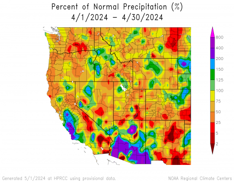

Regional temperatures were slightly above (0 – 2°F) to above (2 – 4°F) normal in April. Small pockets of slightly below (-2 – 0°F) normal temperatures occurred mostly in central Utah and southern Colorado. Small pockets of above (4 – 6°F) normal temperatures occurred in Laramie and Sheridan Counties in Wyoming, with a pocket of 6 – 8°F above normal temperatures in Sheridan County. Small areas of much-above (top 10%) normal temperatures for the month of April were observed in Colorado.
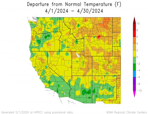
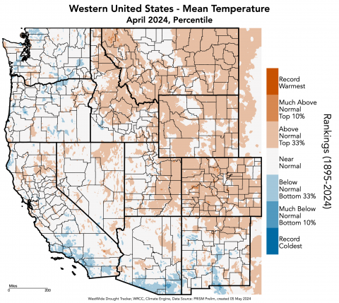
Regional snowpack ranged from much-below (<50%) normal conditions in northeastern Wyoming to above (110-129%) normal conditions in northern and southern Utah. Below normal conditions occurred in northern and western Wyoming and southern Colorado. Near-normal conditions occurred throughout most of Utah, southeastern Wyoming, and northern Colorado. As of May 1st, statewide percent median snow-water equivalent (SWE) was 92% in Colorado, 103% in Utah, and 88% in Wyoming. The Escalante Basin in Utah had the highest percent median SWE at 222% by end of day on April 30. The basins with the lowest percent median SWE were the Belle Fourche and Cheyenne Basins at 0% since they melted out. Peak SWE was observed on April 9 for Colorado (16.7 in), April 2 for Utah (18.8 in), and April 11 for Wyoming (16.2 in).
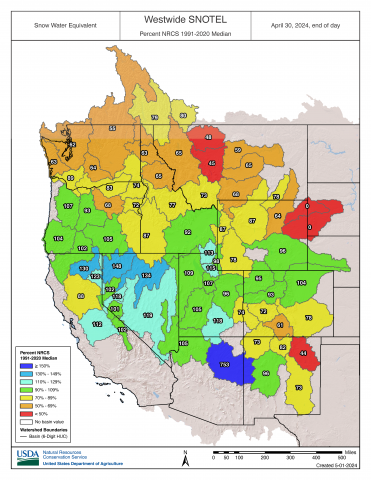
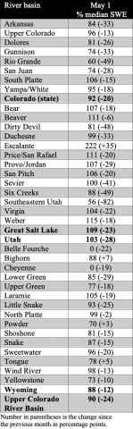
Regional April-July streamflow volume forecasts are mostly below (70-89%) normal to near-normal, with forecasts of 50-69% of normal streamflow in northeastern Wyoming including the Powder and Cheyenne Basins, according to the NRCS, and at many sites in southwestern Colorado including the San Juan, Gunnison, and Upper Colorado-Dolores Basins, according to the CBRFC. There are above (110-129%) normal streamflow forecasts for the basins surrounding the Great Salt Lake, with CBRFC sites forecasting 130-150% of normal streamflow in the Lower Bear, Weber, and Jordan Basins, as well as one site in the Lower Green Basin with a forecast of 150-200% of normal streamflow. The forecast for the inflow to Lake Powell is 80% of average, which is down 9% from the April 1st forecast.
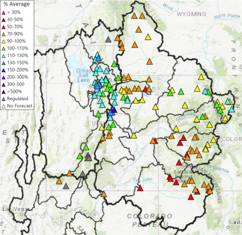

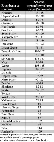
Regional drought conditions improved in April and now cover 10% of the region, a 2% decrease in drought coverage since the end of March. Severe (D2) drought improved in northeastern Wyoming and moderate (D1) drought improved in south-central Colorado, while D1 drought developed in southeastern Colorado.
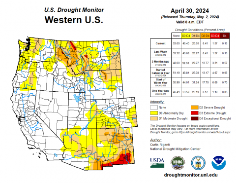
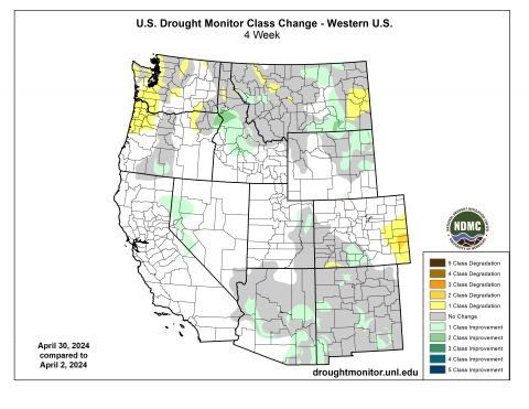
As of mid-April, El Niño conditions are transitioning to neutral-ENSO (El Niño Southern Oscillation) conditions in the Pacific Ocean. There is an 83% chance of neutral-ENSO conditions by May and a 49% chance of La Niña conditions developing by July. The NOAA precipitation and temperature outlooks for May suggest an increased probability of below (33-40%) normal precipitation for southern Colorado and above (33-40%) normal temperatures for southeastern Colorado. The NOAA seasonal precipitation and temperature outlooks for May-July suggest an increased probability of below normal precipitation for southeastern Utah and a majority of western and southern Colorado, and above normal temperatures for almost the entirety of the region with 40-50% above normal conditions for all of Utah, western and southern Wyoming, and western, central, and southern Colorado.

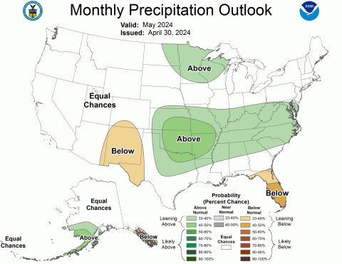
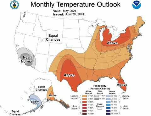

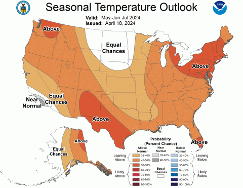
Significant April weather event: Northern Colorado windstorm. An exceptionally strong storm moved through northern Colorado from April 6-7. During this period, strong and destructive winds affected the mountains, foothills, and northeastern plains. Wind speeds in the Front Range mountains and near the foothills peaked between 70 to 95 mph, with the highest recorded gust reaching 97 mph at the NCAR Mesa Lab in Boulder and a close second of 96 mph in Coal Creek Canyon in Jefferson County. Across the northeastern plains, the most intense winds occurred along and north of a line extending from Denver to Fort Morgan to Akron, with wind gusts of 60 to 80 mph. Numerous instances of downed trees, power poles, and minor damage were reported in areas with the strongest winds. Xcel Energy said over 155,000 customers experienced power outages at the height of the storm from a combination of proactive public safety shutoffs and power outages caused by damage from the high winds, with most of these occurring in and around the Denver Metro.
Here are the locations that saw the highest wind gusts from April 6-7, according to NWS:
- NCAR Mesa Lab, Boulder, 97 mph
- Coal Creek Canyon, Jefferson, 96 mph
- 3 NW Marshall, Boulder, 95 mph
- Buckeye, Larimer, 93 mph
- 3 ESE Buckeye, Larimer, 91 mph
- 2 ENE Copper Mountain, Summit, 91 mph
- Rocky Flats Hwy 93 and 72, Jefferson, 90 mph
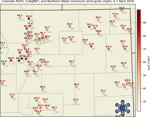
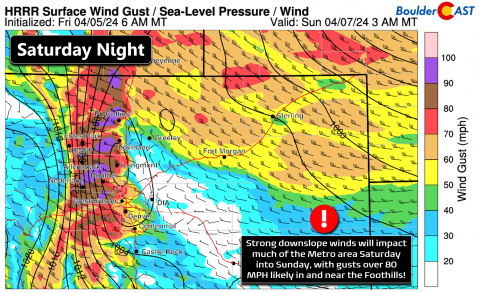

Click the link to read the article on the Inside Climate News website (Phil McKenna):
May 5, 2024
With a pair of fossil-fuel friendly senators at his side, former U.S. Energy Secretary Ernest Moniz on Tuesday released a favorable report on U.S. natural gas and liquified natural gas (LNG), funded by the natural gas industry.
The report, “The Future of Natural Gas in a Low-Carbon World,” was written by the EFI Foundation, a nonprofit Moniz founded, and released at the U.S. Capitol. The report examined the role of natural gas in advancing energy security, energy equity and environmental sustainability in the United States, Europe and Asia.
The EFI report comes at a pivotal moment for the U.S natural gas and LNG export industry. The Biden Administration paused the approval of new LNG export capacity in January while the Energy Department considers the climate and financial impacts to U.S. gas consumers of additional LNG exports. The document seeks to broaden the discussion on U.S. LNG exports.
“The study, as you’ll be hearing, examines the role of natural gas in addressing what is sometimes referred to as the ‘energy trilemma’: energy security, energy equity and environmental sustainability,” said Moniz, president of the EFI Foundation and chair of the advisory committee that oversaw the report. “Unfortunately, too often, the discussion around those three priorities tends to devolve into stovepipes, as opposed to recognizing that progress on all of them requires treating it as one conversation.”
One of the report’s specific recommendations was to include an “energy security determination” in evaluating future permits for additional U.S. LNG export capacity.
Sen. Joe Manchin (D-W.V.), the largest recipient of oil and gas money in Congress, and Sen. Lisa Murkowski (R-Alaska), representing a state that derives a significant share of its revenue from oil and gas, joined Moniz as “keynote” speakers at the event.
Murkowski spoke of the need for an “all of the above” energy policy, which was the U.S. energy policy during the Obama administration when Moniz was Secretary of Energy.
Manchin called for lifting the pause on approvals for new LNG export capacity.
The report referred repeatedly to the “essential” role of natural gas.
The same day as the report’s release, Democrats in Congress released a report of their own, the culmination of a three-year investigation, concluding the oil and gas industry has misled Americans for decades about climate change.
“The fossil fuel industry engaged in an elaborate campaign of deception and doublespeak … as well as disinformation about the climate safety of natural gas and its role as a bridge fuel to a fossil-free future,” the Democrats’ report concluded.
Sen. Sheldon Whitehouse (D-R.I.), who released the report as chairman of the Senate Budget Committee, said the oil and gas industry seeks academic partnerships to legitimize its reports.
“Documents explicitly discuss leveraging ‘third party endorsements’ and partnerships with academic institutions to bolster Big Oil’s disinformation campaign,” Whitehouse said in a written statement to Inside Climate News.
Referring explicitly to the new Moniz report on natural gas, Whitehouse said “this report is yet another example of the industry deceiving the public about the compatibility of continued—or even expanded—production of natural gas with the scientific emission reduction targets we must achieve in order to meet the goals of the Paris Agreement and avoid the very worst effects of climate change.”
A spokeswoman for Democrats on the House Committee on Oversight and Accountability added that industry’s disinformation campaign “continues to this day, including, as [Moniz’s] recent report shows, their portrayal of natural gas as a green and climate friendly fuel even though they have failed to address methane emissions associated with natural gas. We know that Big Oil is intent on entrenching natural gas into both the U.S. and global energy economies for the foreseeable future by any means necessary.”
Some climate researchers echoed her conclusion that the new report may be a continuation of industry-funded misinformation.
“My concern is that Moniz is—and perhaps has been since his time in the administration—an advocate for polluters over people and the planet,” said Michael Mann, an earth and environmental science professor at the University of Pennsylvania and the director of the Penn Center for Science, Sustainability and the Media.
“It strains credulity to believe this is a coincidence,” Mann said of the report’s favorable view of natural gas, given its gas-industry funding. “Unfortunately, the old adage ‘follow the money’ seems quite relevant here.”
In addition to his role at EFI, Moniz is an emeritus professor at the Massachusetts Institute of Technology and a “special advisor” to MIT president Sally Kornbluth.
The EFI Foundation declined to respond publicly to criticisms of the report, and MIT did not respond to a request for comment.
The United States is the world’s largest exporter of LNG. Additional projects already approved by the Energy Department and not subject to the ongoing pause would triple existing U.S. export capacity.
The pause followed the pre-release of a study that is still undergoing peer review by Robert Howarth, a professor at Cornell University. Howarth’s study concluded the climate impact of LNG fuel is worse than burning coal.
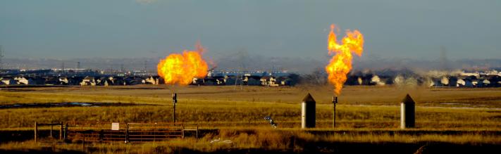
When burned, natural gas emits roughly half as much carbon dioxide as coal. However, methane, the primary component of natural gas, is a highly potent greenhouse gas, more than 80 times more effective at warming the planet than carbon dioxide over a 20-year period. If even a small amount of methane is leaked, vented, or otherwise emitted into the atmosphere before the gas is burned—as it commonly is—the climate impact of natural gas can be worse than that of other fossil fuels.
Whitehouse challenged the energy security claims in the Moniz report.
“There is no energy security for American families and businesses when the price of energy is determined by geopolitical events outside our control and by an industry that frequently engages in cartel-pricing,” he said. “True energy security will be achieved when we fully transition to renewable energy sources, the ‘fuels’ for which—wind, sunlight, flowing water, the earth’s heat—are free and not controlled by any one country or cartel.”
Nonetheless, the European Commission’s executive vice president for the European Green Deal, Maroš Šefčovič, whose responsibilities include leading the European Commission’s work on becoming climate-neutral by 2050, praised the Moniz report in a video address shown at the release event.
“Natural gas has a role to play as a transitional fuel, something reflected in the COP28 conclusions,” Šefčovič said, referring to the 2023 U.N. climate conference in Dubai. “It will help ensure our energy security and energy equity as our economies decarbonize.”
“So with Europe, having taken decisive action to reach net zero by 2050 including by accelerating the clean energy transition, we also recognize the importance of natural gas, notably in the medium term, and LNG in particular will continue to represent a significant source of gas for the EU,” Šefčovič added.
Funders or “sponsors” of the report, which was not peer-reviewed, included Chesapeake Energy, one of the largest independent gas producers in the U.S, and U.S. LNG export companies Venture Global LNG and Tellurian. The American Petroleum Institute and three other gas industry organizations or industry PR groups also provided funding.
Additional money came from the Cynthia and George Mitchell Foundation, named after the late George P. Mitchell, who is often referred to as the “father of fracking” for his role in developing the drilling technology known as hydraulic fracturing. The Institute of Energy Economics, a think tank in Japan, the world’s largest importer of LNG, also provided support.
The report states that the “EFI Foundation maintains editorial independence from its public and private sponsors.” However, more than half of the report’s “advisory committee” was comprised of individuals representing the report’s funders.
“EFI’s report reinforces more than a decade’s worth of independent and government-led research that has consistently shown the long-term role of natural gas in the global energy mix and its ability to accelerate global climate progress while strengthening global energy security,” API spokesperson Scott Lauermann said.
Joseph Romm, a researcher also at the Penn Center for Science, Sustainability and the Media, said the report’s “energy trilemma” framing that looks at energy security, equity and environmental sustainability downplays the importance of climate change.
“Climate is the overriding issue,” Romm said. “Not that the others aren’t important, but if you don’t do climate, the others don’t matter.”
Romm noted that in 2018, the International Energy Agency, a global energy watchdog, concluded that the world could not afford to build any new carbon dioxide emitting projects if the planet were to stay within 2 degrees Celsius of warming, when compared to pre-industrial times.
Six years later, there is even less room for new fossil fuel developments, Romm said.
The EFI report states that carbon capture, utilization and storage (CCUS) is an effective option for reducing CO2 emissions across the natural gas supply chain, even though to date such technology has never been successfully deployed at a commercial level. As the report notes, “there is no natural gas-fired power plant with CCUS in operation worldwide as of July 2023.”
The Inflation Reduction Act and Bipartisan Infrastructure Law have provided tax incentives and billions of dollars for large-scale carbon sequestration projects.
“You shouldn’t go around telling people that, ‘Oh, you’re going to solve whatever your natural gas problem is with carbon capture, utilization and storage’ when there isn’t a single one in operation,” Romm said. “One has to distinguish between reality and wishful thinking.” [ed. emphasis mine]
The Moniz report also says that LNG shippers have started to offer their customers “carbon-neutral LNG cargo,” in which emissions from LNG production are offset through the purchasing of carbon credits.
Carbon offsets have come under increasing scrutiny in recent years as offset projects have failed to live up to their emission reduction claims. Even if the projects offset the emissions of LNG production, there would still be significant emissions when the fuel is burned.
The report acknowledges the climate impact of methane emissions associated with natural gas and says “methane emissions reductions are also critical.” The report also notes that “the carbon footprint of natural gas, while lower than some alternatives, must be dramatically reduced further” and “overcoming these challenges will ultimately determine whether natural gas is indeed a transitional fuel or an integral part of the long-term global energy mix.”
In releasing the report, Moniz said the gas industry “can do a lot more in terms of having the pause be a pause by taking care of some of the homework that needs to be done,” such as on methane emissions reductions.
However, the report focuses less on methane emissions and more on the carbon dioxide emissions reductions that can be achieved by switching from coal to gas.

Whitehouse said the focus on carbon dioxide emissions over methane emissions is misleading, intentional and not new.
“Internal documents obtained in our recent investigation demonstrate that fossil fuel companies knew methane leaks made natural gas just as harmful to the climate as coal but sought to discredit the scientific evidence and paint natural gas as a clean fuel and a crucial part of the energy mix,” Whitehouse said.
One such document obtained through the Congressional investigation was an August 2016 email from Amory Lovins, the cofounder and, at the time, chief scientist for the Rocky Mountain Institute, a clean energy and sustainability research organization now known as RMI. The email was addressed to Rex Tillerson, then the chief executive of ExxonMobil.
Tillerson had just been appointed the chair of the National Petroleum Council, a federal advisory committee to the Secretary of Energy, a position then held by Moniz.
Lovins, who served as an environmental representative on the council, warned Tillerson of increasing methane emissions monitoring by “citizen activists.” He urged Tillerson, the country’s leading oil and gas executive, and his industry to “get ahead of that emerging movement” and “fix the leaks” before the “sloppy operators further damage the good firms’ reputation.”
Another record obtained through the Congressional investigation is a document from Chevron marked “classified,” which includes a presentation Lovins gave to the oil and gas company’s board of directors at a meeting in Pebble Beach, California, in 2018.
In the presentation, Lovins notes that the “#1 threat to gas” is “methane ‘slip,’” or emissions. Lovins added that “2.3% of US gas output is now lost” as emissions, making gas “little/no” better for the climate than burning coal. Lovins added that LNG is “worse” for the climate than coal.
LNG has higher greenhouse gas emissions than natural gas due to the energy it takes to liquify and then regasify natural gas, not counting the additional methane emissions that occur during the transport of LNG in ships.
“RMI experts routinely share their independent analysis and research with a variety of stakeholders, and in this case, we presented our understanding of the climate risks of methane to the oil and gas industry, in the hopes that the facts would lead to solutions,” Lovins said in an email. “The facts presented then and subsequent research from RMI and peers have confirmed that leaks of methane, the main ingredient in natural gas, even at small amounts, make it as bad as or worse than coal for the climate and not necessarily the cleaner alternative it was once thought to be.”
Peer-reviewed studies published since 2018 suggest the climate impact of natural gas is worse than previously thought. A study published last month in Nature found that 2.95 percent of U.S. gas output is emitted rather than the 2.3 percent figure Lovins used in 2018. For the Permian Basin of Texas and New Mexico, where much of the natural gas that is exported from the U.S. as LNG originates, emissions are far higher—9.6 percent—according to the Nature study.
Other factors, such as the use of a 20-year rather than 100-year timeframe for measuring the climate impact of methane, can result in an even smaller leak rate, making natural gas worse than coal. A study published last year in Environmental Research Letters by RMI researchers found a “methane leakage rate as low as 0.2 percent brings a gas system’s climate risk on par with coal.”
For Howarth, the Cornell professor, recent events elicit a sense of déjà vu. In 2011, Howarth published one of the first studies suggesting the climate impact of natural gas may be worse than coal.
The same year, Moniz, then the director of the MIT Energy Initiative, was co-chair of a non-peer-reviewed Energy Initiative report funded largely by industry, “The Future of Natural Gas,” a title nearly identical to the EFI report Moniz and colleagues published this week.
The 2011 report led by Moniz downplayed Howarth’s findings and called for federal policies that “encourage the development of a [global liquid natural gas] market.”
“It feels familiar,” Howarth said of the new “Future of Natural Gas” report. “Shale gas is clearly as bad or worse than coal, no matter what industry funded people want to spin.”
“And even if I were wrong,” Howarth added, “It’s just not the time to be promoting any fossil fuels.”
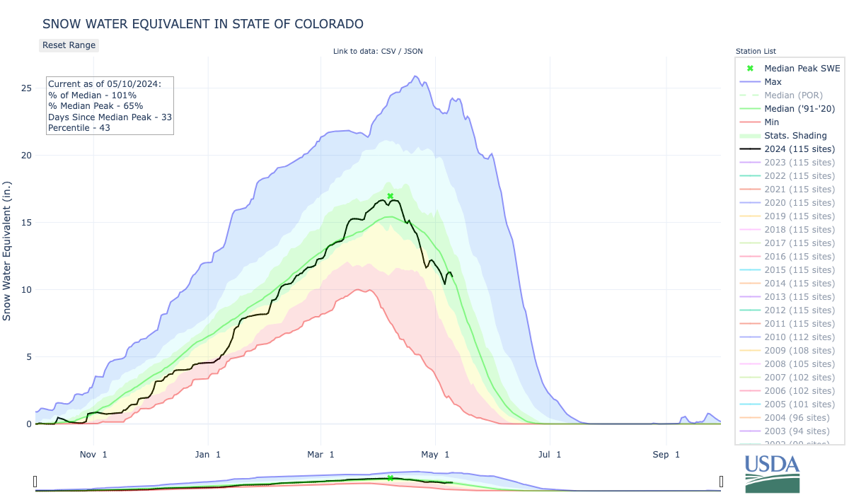
Click the link to read the article on the Fort Collins Coloradoan website (Ignacio Calderon). Here’s an excerpt:
May 7, 2024
Statewide, Colorado is at around 90% of its median snowpack, as of May 3, with some variation across basins.
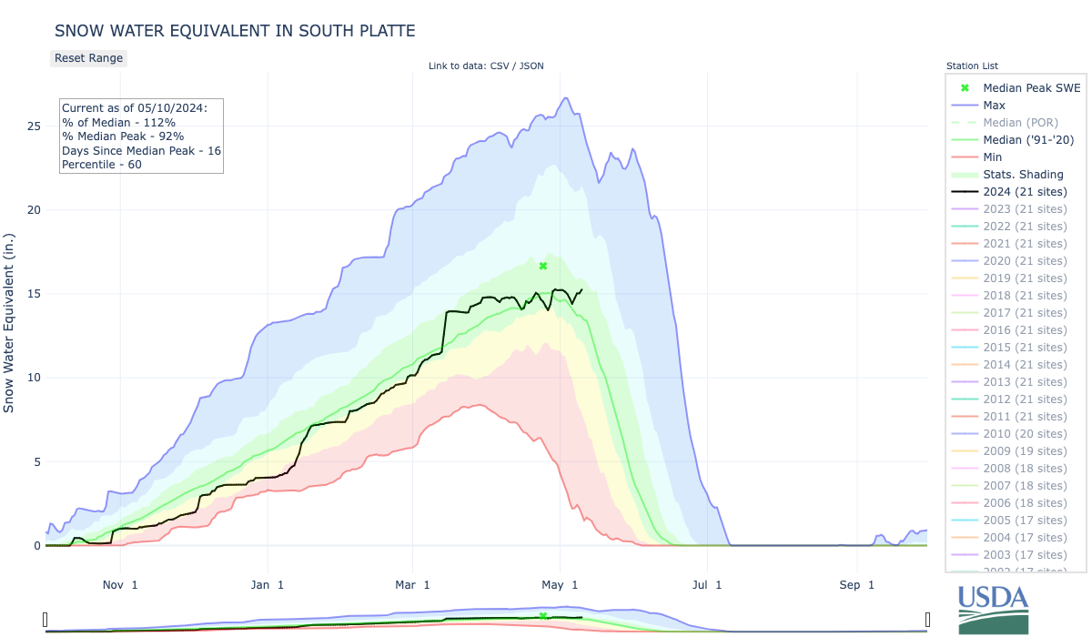
The South Platte, which covers Fort Collins, is at 103% of its median snowpack this season, according to USDA data. Two notable bumps on this year’s snowpack came from the heavy storms in January and March, which dumped feet of snow across the state…
According to CSU’s climate report, “Colorado’s snowpack serves as a huge seasonal reservoir that stores about 15 million acre-feet of water on average at the spring peak and then makes that water available later in the year when water demands for agricultural uses and outdoor watering are higher.”
Studies have shown that SWE has decreased in most places across the state, “though the percentage declines in SWE in Colorado were generally smaller than in most other regions of the West due to Colorado’s relatively high elevations and colder winter climate,” the report says.

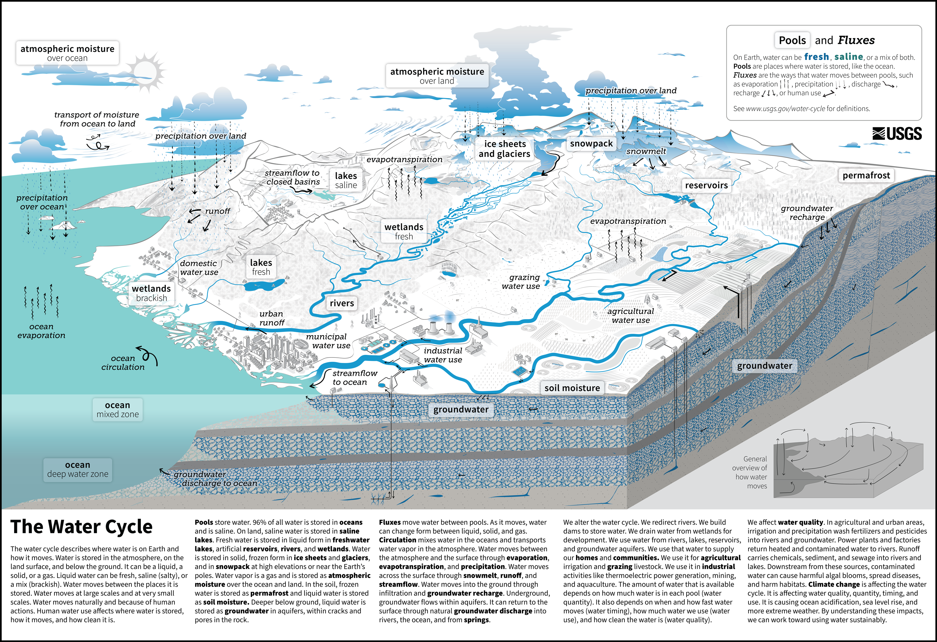
Click the link to read the release on the NGWA website:
May 6, 2024
The U.S. Geological Survey published a report on May 2 on the critical topic of microplastics in the environment.
The report titled “Integrated Science for the Study of Microplastics in the Environment — A Strategic Science Vision for the U.S. Geological Survey” is available on the USGS website.
The report which covers microplastics and nanoplastics states “a myriad of environmental exposure pathways to humans including ingestion, inhalation, and bodily absorption, are likely to exist.” It adds there is growing evidence that bioaccumulation of microplastics in tissues and organs of humans can potentially lead to nutritional and reproductive effects.
Current science gaps are mentioned. The report says that “understanding if or when environmental exposures pose a health risk is complicated by the diversity of microplastic sizes, morphologies, polymer types, and chemicals added during manufacturing or sorbed from the environment; ongoing challenges in analytical methods used to detect, quantify, and characterize microplastics and associated chemicals in our ecosystems; and the fact that ecotoxicological studies regarding microplastics are still in their infancy.”
It also adds that a better understanding of the sources, pathways, fate, and biological effects of microplastics has become a priority of the federal government as well as some state governments.
One of the most cited Groundwater® papers in recent years is “Microplastic Contamination in Karst Groundwater Systems” by Samuel V. Panno et. al. NGWA members can view the complete paper on Wiley Online Library.

Click the link to read the article on the KUNC website (Alex Hager):
May 2, 2024
This story is part of ongoing coverage of the Colorado River, produced by KUNC in Colorado and supported by the Walton Family Foundation. KUNC is solely responsible for its editorial coverage.
Tribes that use the Colorado River want a say in negotiations that will reshape how the river’s water is shared. Eighteen of those tribes signed on to a letter sent to the Bureau of Reclamation, the federal agency that will finalize new rules for managing the river after 2026, when the current guidelines expire.
In the memo, tribal leaders urge the federal government to protect their access to water and uphold long-standing legal responsibilities.
The letter comes as other groups have also been sending the feds their ideas for managing a river that supplies 40 million people across the Southwest but is shrinking due to climate change. Reclamation is considering input from different Colorado River users, including competing proposals from two camps within the seven states that use its water.
The river’s Upper Basin states of Colorado, Utah, Wyoming and New Mexico banded together to send a proposal, and the Lower Basin states – California, Arizona and Nevada – did the same. A coalition of environmental nonprofits sent their own, and a group of high-profile water researchers published another.
The tribes’ letter aims to make sure that Indigenous people, who used the Colorado River before white settlers ever occupied the Western U.S., are not left behind as Reclamation considers those proposals.
“If you are not at the table, you are on the menu,” Jay Weiner, a water lawyer for the Quechan Indian Tribe, said.
Weiner, who helped craft the letter, said it aims to answer the complicated question: What do tribes want?
Each tribe in the Colorado River basin is unique and has interests that make it hard to land on one clear answer to that question, Weiner said, but this memo aims to coalesce a “critical mass” of tribes around broader ideas that are important to tribes.
“This is very much part of the effort of trying to be at the table and engaged so that there are meaningful opportunities for input, for engagement, for dialogue and, frankly, for fighting, when it comes to it,” Weiner said.
Three key principles
In the memo, the co-signing tribes address three main principles.
First, they ask the government to uphold its “trust responsibility” to the tribes.
This goes back to the very foundation of laws that guide relationships between the United States and tribes. When the federal government took property and assets from tribes, it also created a special designation for the tribes, calling them “domestic dependent nations.”
That designation also comes with the “responsibility to do right by those tribes forever,” explained Jenny Dumas, legal counsel on water for the Jicarilla Apache Nation and another architect of the tribal principles letter.
“The tribes gave up a lot of things when they entered into treaties with the federal government,” she said, “But what they did not give up was their right to a sufficient supply of water to provide for their people forever and ever in perpetuity.”
The letter urges federal water managers to fulfill that responsibility by rejecting any new water rules that would encroach on the government’s obligation to make sure tribes have access to water, and to adequately compensate any tribes that are forced to take water cuts in times of shortage.
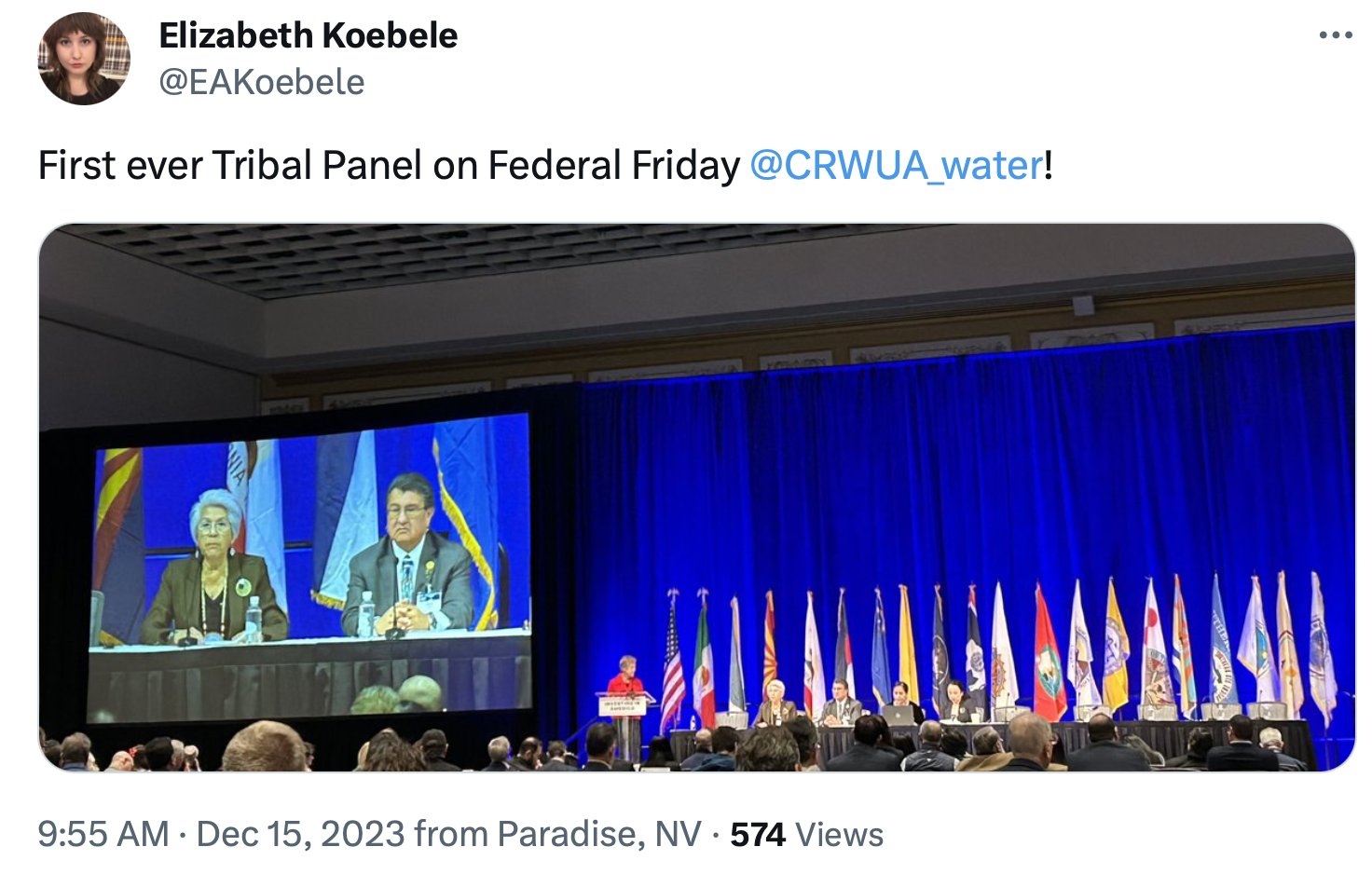
The letter also asks the feds for better ways to financially benefit off of the water they own.
Tribes hold rights to about a quarter of the river’s flow, but many lack the funding and infrastructure to use their full allocations and instead leave it in the river. The letter lays out a few specific ways the U.S. government could help change that.
One of those ways is to “maximize” tribes’ ability to participate in conservation programs. Armed with a $4 billion pool of money from the Inflation Reduction Act, the federal government has been funding programs to pay water users – often farmers and ranchers – to pause water use and leave some extra water in reservoirs. Some tribes are already receiving conservation payouts, but the letter advocates to expand tribal participation.
In addition, the memo asks feds to make it easier for tribes to market or lease their water rights to water users that reside outside of tribal land. That could open the door to new revenue streams, participation in conservation programs or the construction of new water infrastructure.
Finally, the letter asks the U.S. government to establish a permanent, formalized way for tribes to participate in talks about water use during ongoing negotiations and any other time Colorado River policy is discussed in the future.
Tribes have long been pushing for better representation in negotiations about the Colorado River. Indigenous people were excluded from talks that set the foundation for how water is shared in the Southwest over a century ago, and tribes say they’re still being left out now.
In the letter to Reclamation, tribal leaders wrote that river negotiations in 2007 had a “lack of formal tribal inclusion,” and reminded federal water managers that in 2023, federal officials made it a stated goal to enhance engagement and inclusion of tribes going forward.
The tribes are asking for something specific. Certain steps in negotiations about Colorado River water trigger the federal government to talk to states that use its water. The tribes want to make sure they are also consulted any time that trigger is hit.
Ultimately, the letter’s authors say tribes—and the legal infrastructure that governs tribal water use—are unique in a way that has to be considered when drawing up new rules that could have a big impact on the cities and farms of the Southwest.
“Tribal water rights are different,” Dumas said. “They’re not the same as non-Indian water rights. And for that reason, they deserve different protections and special treatment. And that’s what we’re asking for in this letter.”
‘Tribes have survived a whole lot worse’
While exclusion of tribes has been an undercurrent of Colorado River negotiations for at least a century, tribal leaders say times are changing.
Jason Hauter, legal counsel on water issues for the Gila River Indian Community who helped craft the letter, said the U.S. government faces “billions of dollars of potential liability” without the buy-in of Gila River and other tribes and that having unwilling water users could slow down the authorization and implementation of new water rules.
“Tribes are a key stakeholder,” said Hauter, who is a member of the Gila River Indian Community. “The days of being able to politically roll tribes and them not being sophisticated enough to put up strong challenges to federal rulemaking are over.”
Even after the letter’s submission, the number of tribes adding their support has grown. An early version of the memo was co-signed by 16 tribes. That number now stands at nineteen.
One of the late additions was the Gila River Indian Community, which holds lands in the Phoenix area. The tribe has been among the most prominent in Colorado River negotiations, and has become a high-profile partner to Arizona and the federal government in recent conservation programs.
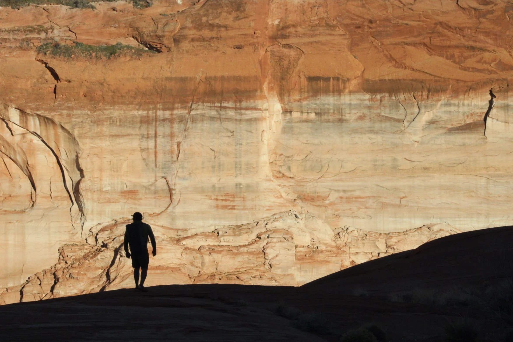
In March, Gila River’s governor, Stephen Roe Lewis, announced the tribe did not support the Lower Basin proposal that Arizona signed on to, and that it planned to file its own. Instead, the community joined as a co-signer of the tribal principles letter in late April.
Indigenous leaders are quick to point out that each tribe is unique, and common ground can be hard to find amid the geographical, political and financial differences between them. This letter, however, is designed to focus on ideas so broad that they can find consensus among nearly two-thirds of all tribes that use Colorado River water.
“The goal should be having a stable system, not necessarily picking winners and losers,” Hauter said. “There’s a lot of posturing between the Upper and Lower Basin, and without really focusing on the ultimate goal: How do we make a better system? Given what the basin is facing, a recognition that there has to be shared pain among the basin states and among tribes. Finding ways to do that in a fair way, in a way that can make sense, that’s the challenge we all face.”
Conversations about Colorado River management have, for the past couple years, largely focused on the re-negotiation deadline in 2026. While it has been framed as a momentous juncture in the timeline of Western water management, tribes and their representatives say they’re focused on a longer view.
Jay Weiner, water lawyer for the Quechan Indian Tribe, said even if climate change makes the Southwest unpalatable for white people and other settlers, tribes plan to stay in their historic homelands.
“None of these things are single, one-off immutable events,” he said, “Because tribes have survived a whole lot worse than anything we’re gonna see coming out of post-2026 guidelines.”
Click the link to read the article on the NOAA website:
Key Points:
- A severe weather outbreak generated more than one hundred tornadoes, including one EF-4, across the Midwest and Great Plains on April 25–28, causing significant damage and loss of life and becoming the worst tornado outbreak to date for the year.
- During early April, a spring snowstorm brought heavy snow and powerful winds to much of New England, downing trees and knocking out power to hundreds of thousands in the region.
- January to April 2024 was the fifth-warmest such four-month period on record for the nation and precipitation ranked in the wettest third of the historical record for the month of April 2024.
Other Highlights:
Temperature
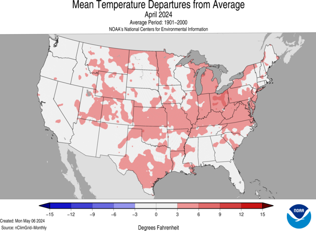
The average temperature of the contiguous U.S. in April was 53.8°F, 2.7°F above average, ranking 12th warmest in the 130-year record. April temperatures were above average across much of the contiguous U.S., while near- to below-average temperatures were observed in parts of the West, northern Plains, Upper Midwest, Southeast and in small pockets of the Northeast. Virginia and West Virginia each had their fifth-warmest April on record.
The Alaska statewide April temperature was 27.2°F, 3.9°F above the long-term average, ranking in the warmest third of the 100-year period of record for the state. Above-average temperatures were observed across most of the state with near- to below-normal temperatures in parts of the Southwest and in parts of the Panhandle.

For January–April, the average contiguous U.S. temperature was 43.0°F, 3.8°F above average, ranking fifth warmest on record for this period. Temperatures were above average across nearly all of the contiguous U.S., while record-warm temperatures were observed in parts of the Northeast and Great Lakes. Wisconsin, Michigan, New York, Vermont, New Hampshire and Maine each ranked second warmest for the January–April period.
The Alaska January–April temperature was 13.9°F, 3.6°F above the long-term average, ranking in the warmest third of the historical record for the state. Much of the state was above normal for this four-month period while temperatures were near average across parts of the East, Southeast and parts of the Panhandle.
Precipitation

April precipitation for the contiguous U.S. was 2.77 inches, 0.25 inch above average, ranking in the wettest third of the historical record. Precipitation was below average across much of the West, Southeast, and parts of the central and southern Plains. Conversely, precipitation was above normal from portions of the Plains to the Northeast, and in parts of the Southwest. Indiana and Pennsylvania each had their fifth-wettest April on record.
Alaska’s average monthly precipitation ranked in the driest third of the historical record. Precipitation was above average in parts of the North Slope and West Coast, while below-normal precipitation was observed in parts of the Southeast Interior and Panhandle during the month.
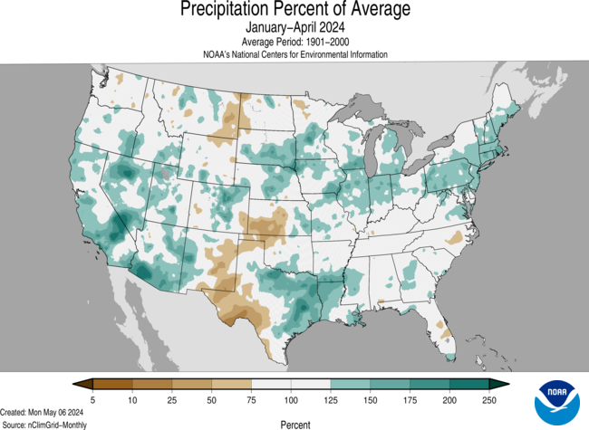
The January–April precipitation total for the contiguous U.S. was 10.95 inches, 1.48 inches above average, ranking 11th wettest in the 130-year record. Precipitation was above average across much of the contiguous U.S., with Pennsylvania having its second-wettest year-to-date period on record. Conversely, precipitation was below average across parts of the Northern Tier and western and southern Plains, and in a small portion of the Southeast during the January–April period.
The January–April precipitation for Alaska ranked in the middle third of the 100-year record, with above-average precipitation observed across much of the state, while near-normal precipitation was observed in parts of the northeast Interior and along parts of the Gulf of Alaska coast. Below-average precipitation were observed in portions of Interior and south-central Alaska and parts of the southern Panhandle during this period.
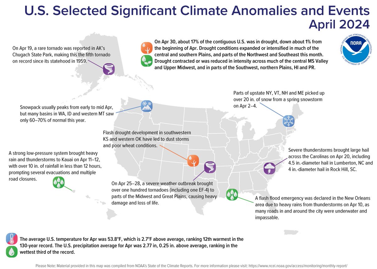
Billion-Dollar Disasters
Five new billion-dollar weather and climate disasters were confirmed in April 2024, including three severe storm events that impacted the central, southern and eastern U.S. in mid-February and early April. There were also two winter storms that impacted the northwest and central U.S. in mid-January.
There have been seven confirmed weather and climate disaster events this year, each with losses exceeding $1 billion. These disasters consisted of five severe storm events and two winter storms.
The U.S. has sustained 383 separate weather and climate disasters since 1980 where overall damages/costs reached or exceeded $1 billion (including CPI adjustment to 2024). The total cost of these 383 events exceeds $2.720 trillion.Other Notable Events
A spring storm brought rain, heavy snow, damaging winds and thunderstorms across much of the Great Lakes on April 2, knocking out power to over 100,000 people across the region during the height of the storm.
Severe weather across the Southeast produced a hailstorm that caused over $5 million in damages in Rock Hill, SC on April 20.
On April 26, severe weather across the central Plains resulted in the National Weather Service in Omaha, Nebraska issuing 48 tornado warnings—the most the office has ever issued in a single day.
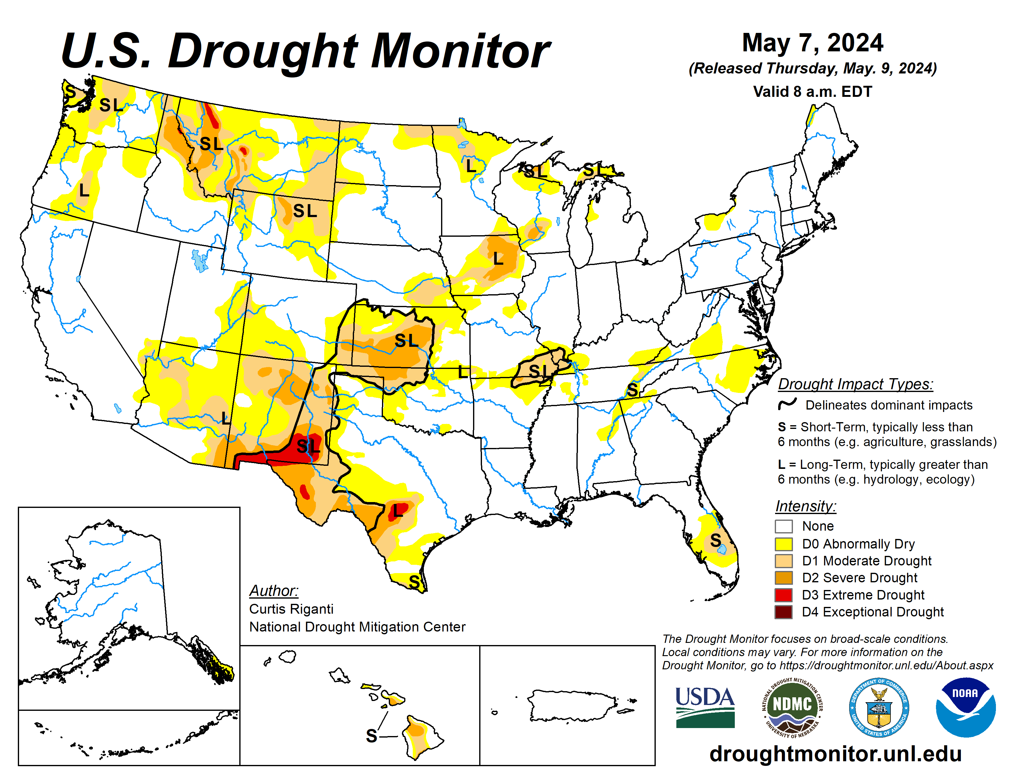
Drought
According to the April 30 U.S. Drought Monitor report, about 17% of the contiguous U.S. was in drought, down about 1% from the beginning of April. Drought conditions expanded or intensified in much of the central and southern Plains, and parts of the Northwest and Southeast this month. Drought contracted or was reduced in intensity across much of the central Mississippi Valley and Upper Midwest, and in parts of the Southwest, northern Plains, Hawaii and Puerto Rico.
Monthly Outlook
Above-average temperatures are favored to impact areas from the southern Plains to the East Coast in May while above-average precipitation is likely to occur from much of the central Plains to the Mid-Atlantic and parts of the Upper Midwest. Drought is likely to persist along portions of the Northern Tier, the Southwest and Hawaii. Visit the Climate Prediction Center’s Official 30-Day Forecasts and U.S. Monthly Drought Outlook website for more details.
Significant wildland fire potential for May is above normal across the Hawaiian Islands and in portions of the Southwest and Florida Peninsula. For additional information on wildland fire potential, visit the National Interagency Fire Center’s One-Month Wildland Fire Outlook

Click the link to read the discussion on the CPC website:
May 9, 2024
ENSO Alert System Status: El Niño Advisory / La Niña Watch
Synopsis: A transition from El Niño to ENSO-neutral is likely in the next month. La Niña may develop in June-August (49% chance) or July-September (69% chance).
During April 2024, below-average equatorial sea surface temperatures (SSTs) emerged in small regions of the eastern Pacific Ocean. However, above-average SSTs prevailed across the rest of the equatorial Pacific. The latest weekly Niño index values remained between +0.5°C and +0.8°C in all regions, except for Niño-3 which was +0.3°C. Below-average subsurface temperatures held steady during the month with negative anomalies extending from the Date Line to the eastern Pacific Ocean. Low-level wind anomalies were easterly over the western equatorial Pacific, while upper-level winds were near average. Convection was near average overall across the equatorial Pacific Ocean and Indonesia. Collectively, the coupled ocean-atmosphere system reflected the continued weakening of El Niño and transition toward ENSO-neutral.
The most recent IRI plume favors an imminent transition to ENSO-neutral, with La Niña developing during July-September 2024 and then persisting through the Northern Hemisphere winter. The forecast team continues to favor the dynamical model guidance, which suggests La Niña could form as early as June-August 2024, with higher confidence of La Niña during the following seasons. La Niña generally tends to follow strong El Niño events, which also provides added confidence in the model guidance favoring La Niña. In summary, a transition from El Niño to ENSO-neutral is likely in the next month. La Niña may develop in June-August (49% chance) or July-September.
Click the link to read the release on Governor Gordon’s website:
May 9, 2024
CHEYENNE, Wyo. – Governor Mark Gordon announced that Wyoming has filed two lawsuits challenging new rules from the Environmental Protection Agency (EPA) that target Wyoming’s coal and natural-gas fired power plants.
Today, Wyoming joined a coalition of 24 states challenging the Biden Administration’s recently released power plant regulations. The states argue that the new rule exceeds EPA’s authority and ignores the United States Supreme Court’s 2022 decision vacating Obama-era greenhouse gas limits for power plants. The suit asks the U.S. Court of Appeals for the District of Columbia Circuit to review and declare the regulations unlawful.
On May 8, Wyoming and 22 other states filed a lawsuit challenging another EPA rule that would require certain air emissions from coal-fired plants to be reduced drastically, with no corresponding health benefits and with great costs to Wyoming and its industries.
“The Biden Administration’s EPA seems determined to use unlawful rulemaking to continue its attacks on Wyoming’s core industries,” Governor Gordon said. “The only goal appears to be destroying Wyoming’s fossil fuel industry by further burdening our power plants, increasing costs to consumers, and threatening the stability of our nation’s electrical grid.”
Click the link to read the article on the WyoFile website (Angus M. Thuermer Jr.):
April 24, 2024
Federal environmental officials have rejected a request by Aethon Energy to pump Moneta Divide oilfield wastewater into the Madison aquifer, saying the deep reservoir could be used for drinking water, especially by tribal nations on the Wind River Indian Reservation.
The Wyoming Oil and Gas Conservation Commission in November 2020 approved wastewater disposal into the 15,000-foot deep well, but the U.S. Environmental Protection Agency said last week the state’s decision did not align with federal rules.
Aethon’s plan does not support a finding “that the aquifer cannot now and will not in the future serve as a source of drinking water,” the EPA wrote in a 20-page record of decision. Aethon argued, and the Wyoming commission agreed 4-1, that the underground Madison formation was too deep and remote to be used for drinking water.
The EPA relied on the Safe Drinking Water Act as the authority under which to protect the aquifer. It also cited climate, environmental justice and tribal interests in its decision, pointing to the nearby Wind River Indian Reservation as a community that could use the water.
“The significance of that is the EPA finally didn’t wimp out on us,” said Wes Martel, a member of the Wind River Water Resources Control Board. “We’re just glad they now have some people in place following up on their Indian policy.”
The Eastern Shoshone and Northern Arapaho Tribes “foresee increased reliance on groundwater for drinking water purposes and anticipate needing to access deeper aquifers, such as the Madison aquifer, as the climate changes and water resources grow scarcer,” the EPA wrote in a 94-page analysis of tribal interests. The agency cited historic cultural and spiritual ties to the land and water and tribes’ status as sovereign nations in its decision.
“We have to make sure our future generations have a reliable source of clean water,” Martel said. “Our reservation, this is all we have left. We’ve got to do our best to protect it.”
The Powder River Basin Resource Council, along with the Wyoming Outdoor Council and others, has spent years monitoring discharge reports and industry permits and was vital in challenging pollution threats, Martel said.
The EPA understood that science, and the law did not support Aethon’s request, said Shannon Anderson, organizing director and staff attorney with the resource council. “They recognized the value of our groundwater resources and the need to protect those into the future,” she said, hailing the decision.
Vast quantities of water
Aethon must find a way to dispose of produced water — a brine pumped from energy wells to release gas and oil — as it expands the Moneta Divide field by 4,500 wells. The U.S. Bureau of Land Management authorized that expansion in 2020, leaving the question of water disposal to Wyoming, which has authority over surface and underground water quality under overarching federal standards.
Aethon must find a way to dispose of the equivalent of 120 Olympic-sized swimming pools full of produced water a day to expand the field. Aethon and Burlington Resources, a co-producer at Moneta, could generate $182 million a year in federal royalties, $87.5 million a year in Wyoming severance taxes and $106 million annually in County Ad Valorem taxes from the expansion.

But Aethon has violated state permits that allow it to pump some produced water into Alkali and Badwater creeks that flow into Boysen Reservoir, a drinking water source for the town of Thermopolis. Wyoming’s Department of Environmental Quality has notified the Dallas-based investment company of its infraction and has required Aethon to reduce the salinity of surface discharges this year.
The DEQ this year listed the two creeks as “impaired” and unable to sustain aquatic life. Underground injection of wastewater into the Madison was to be a new component of the disposal program.
The EPA cited climate change, drought, increasing temperatures and use of reservation surface water by others as some of the reasons to preserve the Madison aquifer.
“Removing the existing statutory and regulatory protections for a potential source of high-quality drinking water for the rural and overburdened communities in Fremont County and on the WRIR would further exacerbate existing inequities particularly with respect to historic and ongoing adverse and cumulative impacts to water resources and community health,” the EPA wrote.
“Thus, equity and environmental justice considerations, which include Tribal interest considerations, support maintaining the existing [Safe Drinking Water Act] protections that apply to the aquifers consistent with Congressional intent to protect both current and potential future sources of drinking water,” EPA documents state.
Neither Aethon nor a representative of the Oil and Gas Conservation Commission responded immediately to a request for comment Wednesday. But WyoFile received this response from Tom Kropatsch, oil and gas supervisor for the Wyoming Oil and Gas Conservation Commission, shortly after publication:
“We do not agree with EPA’s decision on this application. We are still reviewing their decision and the information utilized by EPA in support of their decision. Much of this information was not part of the original application or a part of the record. EPA did not follow the standard procedure of allowing the WOGCC and the applicant to review and respond to the additional information they had available prior to making their final decision. EPA evaluated data that differs in its geographic, geologic, engineering, and other technical information. EPA also inappropriately related the proposed injection location to other areas of the state. Since the data EPA reviewed does not accurately reflect the conditions at the location of the proposed disposal well it is not appropriate to rely on it for a decision on this application. The WOGCC is reviewing EPA’s decision and weighing its options for further action.”

Click the link to read the article on The Denver Post website (John Aguilar). Here’s an excerpt:
May 9, 2023
Thornton will be able to build a critical segment of a 70-mile pipe to bring water from the Cache la Poudre River to the fast-growing suburb north of Denver, after elected leaders in Larimer County unanimously — if begrudgingly — approved a permit for the northern segment of the pipe on Wednesday night…But a procession of county residents has spoken out against the proposed project at a series of public hearings held over the past couple of weeks, insisting that Thornton simply could allow its shares in the Poudre River — equaling 14,700 acre-feet a year — to flow through Fort Collins before taking the water out for municipal use. Doing so, they say, would increase flows and improve the river’s health. But just hours before Wednesday’s meeting, one of the opposition groups to the project — No Pipe Dream — said it sensed momentum had turned the city’s way, issuing a public statement that said “we’ll skip the torture of tonight’s hearing on our ‘good neighbor’ Thornton’s plans to win the water tap lottery and appease hungry developers.”
[…]
Before casting her yes vote Wednesday, Larimer County Commissioner Kristin Stephens said she wished Thornton would send its water down the Poudre “because that’s what the community wants.”
[…]
“We can’t do that,” she said, referring to a 2022 Court of Appeals decision that ruled that Larimer County cannot force Thornton to use the river as a conveyance…
The fight over Thornton’s water pipe has been going on for years, and a denial of a permit for the project by Larimer County’s commissioners more than five years ago set off a flurry of unsuccessful court challenges that ultimately prompted the city this year to resubmit its application — this time with a different route and 17 fewer miles of pipe within the county’s boundaries. The city also relocated a pump house from the original plan to a site that is not near any houses, and it agreed to 83 county land use conditions to move the project forward.

Click the link to read “Larimer County commissioners approve city of Thornton’s water pipeline application” on the Fort Collins Coloradoan website (Rebecca Powell). Here’s an excerpt:
May 9, 2024
Commissioners Kristin Stephens, Jody Shadduck-McNally and John Kefalas all said they believed the permit application, now with 83 conditions, met the criteria set by the county’s 1041 regulations that govern the permit process…[John Kefalas] said while advocates have suggested that Thornton’s 2023 application is no different than the one submitted a few years ago, “I must respectfully disagree, as the pipeline proposal and process have been different.”
[…]
Kefalas said the county legal counsel’s “prudent” interpretation of a 2002 Colorado Court of Appeals ruling, which sided with commissioners in their decision to reject but also said the county couldn’t require the water to be run through the Poudre, indicates what could be decided if the matter returns to the courts…
Thornton representatives have said that the water they are conveying is already being taken out of the river at a diversion point to the Larimer County canal. No additional diversions will be made after the project is complete, they’ve said. Shadduck-McNally said she looked thoroughly and critically at the 3,000-page application to make sure it complied with the criteria and believes the county’s higher standards did lead to a stronger application from Thornton.
“This is the system that we have in Colorado — the Colorado water system and the Colorado water court system — and I wish it was different, but it’s the system that I can’t change today. Water court and water decrees are serious business.”


