Albert Van Dijk, Australian National University
Last year, Earth experienced its hottest year on record − for the fourth year in a row. Rising temperatures are changing the way water moves around our planet, wreaking havoc on the water cycle.
The 2024 Global Water Monitor Report released today shows how these changes are driving extreme events around the world. Our international team of researchers used data from thousands of ground stations and satellites to analyse real-time information on weather and water underground, in rivers and in water bodies.
We found rainfall records are being broken with increasing regularity. For example, record-high monthly rainfall totals were achieved 27% more frequently in 2024 than at the start of this century. Record-lows were 38% more frequent.
Water-related disasters caused more than 8,700 deaths and displaced 40 million people in 2024, with associated economic losses topping US$550 billion (A$885 billion). The number and scale of extreme weather events will continue to grow, as we continue pump greenhouse gases into an already overheated atmosphere. The right time to act on climate change was about 40 years ago, but it’s not too late to make a big difference to our future.
Humanity in hot water
Warmer air can hold more moisture; that’s how your clothes dryer works. The paradoxical consequence is that this makes both droughts and floods worse.
When it doesn’t rain, the warmer and drier air dries everything out faster, deepening droughts. When it rains, the fact the atmosphere holds more moisture means that it can rain heavier and for longer, leading to more floods.
Ferocious floods
Torrential downpours and river floods struck around the world in 2024.
In Papua New Guinea in May and India in July, rain-sodden slopes gave way and buried thousands of people alive. Many will never be found.
In southern China in June and July, the Yangtze and Pearl Rivers flooded cities and towns, displacing tens of thousands of people and causing more than US$500 million (A$805 million) in crop damages.
In Bangladesh in August, heavy monsoon rains and dam releases caused river flooding. More than 5.8 million people were affected and at least one million tonnes of rice were destroyed.
Meanwhile, Storm Boris caused major flooding in Central Europe in September, resulting in billions of euros in damage.
Across western and central Africa, riverine floods affected millions of people from June to October, worsening food insecurity in an already vulnerable region.
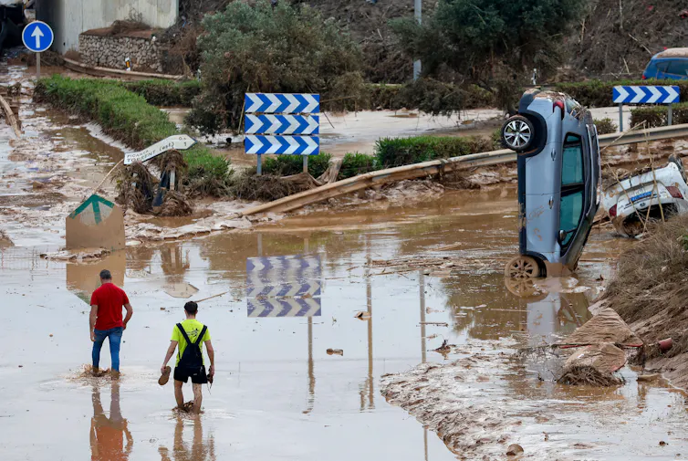
In Spain, more than 500 millimetres of rain fell within eight hours in late October, causing deadly flash floods.
Devastating droughts
Other parts of the world endured crippling drought last year.
In the Amazon Basin, one of the Earth’s most vital ecosystems, record low river levels cut off transport routes and disrupted hydropower generation. Wildfires driven by the hot and dry weather burned through more than 52,000 square kilometres in September alone, releasing vast amounts of greenhouse gases.
In southern Africa, drought reduced maize production by more than 50%, leaving 30 million people facing food shortages. Farmers were forced to cull livestock as pastures dried up. The drought also reduced hydropower output, leading to widespread blackouts.
A rapidly changing climate
Over recent years, we have become used to being told the year just gone was the warmest on record. We will be told the same thing many times more in years to come.
Air temperatures over land in 2024 were 1.2°C warmer than the average between 1995 and 2005, when the temperature was already 1°C higher than at the start of the industrial revolution. About four billion people in 111 countries – half of the global population − experienced their warmest year yet.
The clear and accelerating trend of rising temperatures is speeding up an increasingly intense water cycle.
What can be done?
The Global Water Monitor report adds to a growing pile of evidence that our planet is changing rapidly.
Further change is already locked in. Even if we stopped releasing greenhouse gases today, the planet would continue warming for decades. But by acting now we still have time to avoid the worst impacts.
First, we need to cut greenhouse gas emissions as quickly as possible. Every tonne of greenhouse gas we do not release now will help reduce future heatwaves, floods and droughts.
Second, we need to prepare and adapt to inevitably more severe extreme events. That can mean stronger flood defences, developing more drought-resilient food production and water supplies, and better early warning systems.
Climate change is not a problem for the future. It’s happening right now. It’s changing our landscapes, damaging infrastructure, homes and businesses, and disrupting lives all over the world.
The real question isn’t if we should do something about it — it’s how quickly we still can.
The following people collaborated on the 2024 report: Jiawei Hou and Edison Guo (Australian National University), Hylke Beck (King Abdullah University of Science and Technology, Saudi-Arabia), Richard de Jeu (Netherlands), Wouter Dorigo and Wolfgang Preimesberger (TU Wien, Austria), Andreas Güntner and Julian Haas (Research Centre For Geosciences, Germany), Ehsan Forootan and Nooshin Mehrnegar (Aalborg University, Denmark), Shaoxing Mo (Nanjing University, China), Pablo Rozas Larraondo and Chamith Edirisinghe (Haizea Analytics, Australia) and Joel Rahman (Flowmatters, Australia).
Albert Van Dijk, Professor, Water and Landscape Dynamics, Fenner School of Environment & Society, Australian National University
This article is republished from The Conversation under a Creative Commons license. Read the original article.