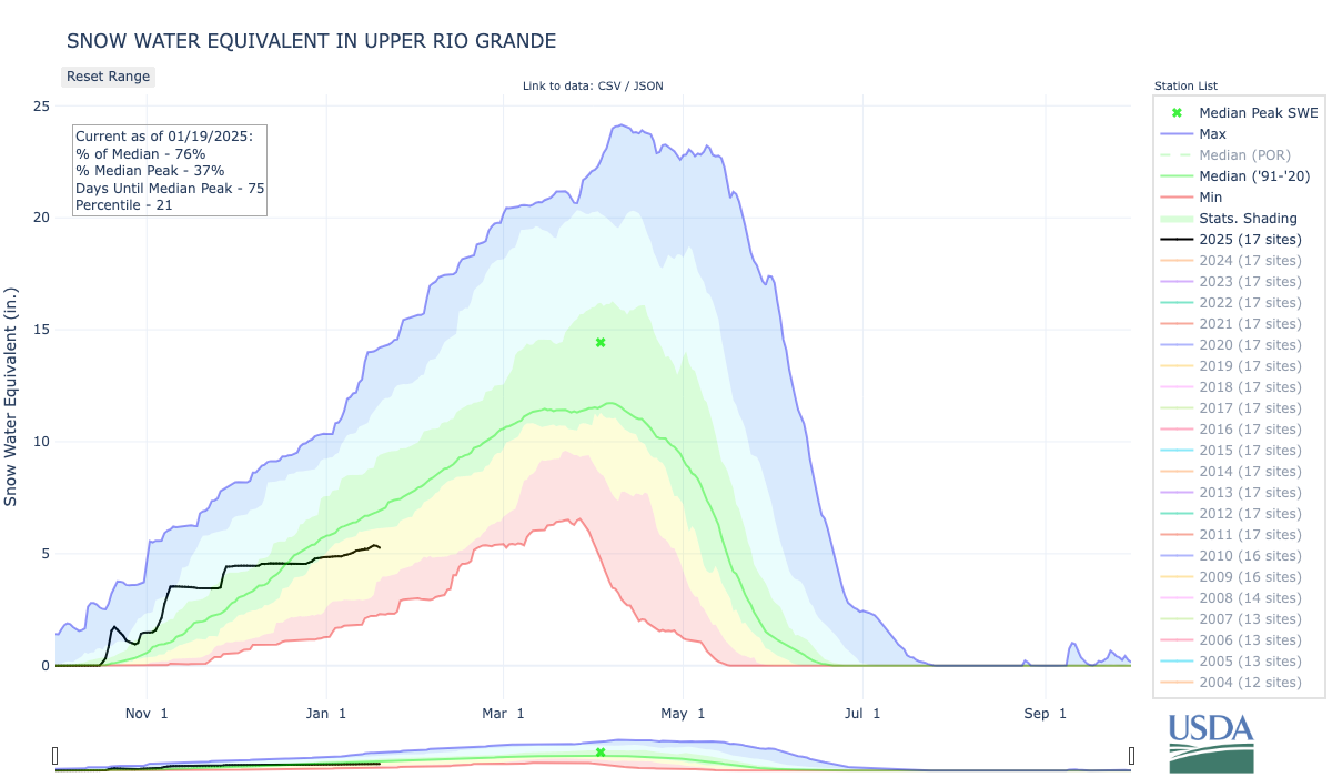
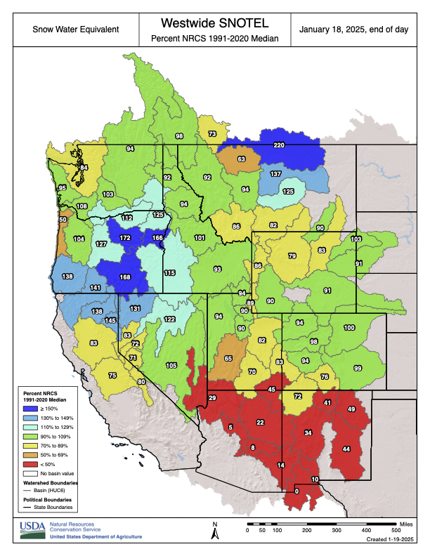
The January NRCS Rio Grande runoff forecast is lousy: a mid-point forecast of 65 percent of average at Otowi (upstream of Albuquerque) and 37 percent of average at San Marcial (downstream of Albuquerque). Based on the current snowpack, I expected worse. Forecaster Karl Wetlaufer, in the email distributing the numbers, explains:
Wetlaufer also reminds us that there’s a lot of snowpack season ahead of us. The numbers above are the median forecast. The one-in-ten wettest side (10 percent exceedence) is ~115% of average at Otowi, and the one-in-ten dry (90 percent exceedence) is less than 20% of average.
Red Water Pond Road Community leader, Larry King, addresses plans to relocate the Quivera Mine Waste Pile that is located about 1,000 feet from the closest residence. Shayla Blatchford
As a child, herding her grandmother’s sheep, Teracita Keyanna unknowingly wandered onto land contaminated with radioactive waste from three abandoned uranium mine and mill waste sites located near her home on the Navajo Nation.
Keyanna and other Diné citizens have been living with the consequences of uranium mining near the Red Water Pond Road community since the 1960s. But now, uranium waste rock that has sat for decades at a Superfund site will finally be moved to a landfill off tribal land.
“This is a seismic shift in policy for Indigenous communities,” said Eric Jantz, an attorney for the New Mexico Environmental Law Center.
On Jan. 5, in a first-of-its-kind move, the Environmental Protection Agency signed an action memo to transport 1 million cubic yards of low-grade radioactive waste from the Quivira Mining Co. Church Rock Mine to a disposal site at the Red Rock Regional Landfill. The Northwest New Mexico Regional Solid Waste Authority owns and operates the landfill, which is located about 6 miles east of Thoreau, New Mexico.
“I feel like our community has finally had a win,” Keyanna said. She is a member of the Red Water Pond Road Community Association, a grassroots organization made up of Diné families that have been advocating for the waste removal for almost two decades. “It’ll help the community heal.”
Companies extracted an estimated 30 million tons of uranium ore on or near the Navajo Nation from 1944 to 1986, largely to fuel the federal government’s enormous nuclear arsenal. When the mines were abandoned in the 1980s, the toxic waste remained. Today, there are hundreds of abandoned mines in plain sight on the Navajo Nation, contaminating the water, air and soil. Altogether, there are an estimated 15,000 uranium mines across the West — 1,200 of them on the Navajo Nation alone — with the majority located in the Four Corners region.
The impact of all this mining on Diné communities has been devastating. A 2008 study found uranium contamination in 29 water sources across the Navajo Nation, while other studies show that people living near waste sites face a high risk of kidney failure and various cancers.
At Quivira, the cleanup is set to begin in early 2025 and will continue for six to eight years, according to an EPA news release. The permitting process, which will provide opportunity for public comment, will be overseen by the New Mexico authority that manages the proposed waste site and is responsible for its long-term safety monitoring.
Mine Waste Area with Limited Vegetation. Photo credit: EPA
The EPA had considered multiple options for waste remediation. But for years, Red Water Pond Road advocates and other local organizations continually pushed it to simply remove the waste, a course of action that the EPA has never taken before, even though the Navajo Nation has repeatedly called for the federal government to move all uranium waste from Diné tribal land.
Throughout the Navajo Nation, said Jantz, “prior to this decision, EPA’s primary choice in terms of remediation of mine was to bury the piles under some dirt and plant some grass seeds on top, called cap in place.” But studies have shown that this approach is not effective at containing radioactive waste in the long term, he said.
The agency took a similar approach when addressing the other uranium waste in the Church Rock area. In 2013, the EPA and the Nuclear Regulatory Commission, which oversees uranium mine-waste cleanup, dumped 1 million cubic yards of waste from the Northeast Church Rock Mine — a different waste site, roughly 3 miles from the Quivira Mine — on top of existing tailings located half a mile from the Red Water Pond Road communities.
But the EPA plans to handle the Quivira Mine’s waste differently, placing it in geoengineered disposal cells with a groundwater leak protection system after it is moved off-site, an approach that Jantz called “state-of-the-art.”
The Quivira Mine cleanup is part of the 2014 Tronox settlement, which provided $5.15 billion to clean up contaminated sites across the United States. The settlement allocated $1 billion of those funds to clean up 50 uranium mines across the Navajo Nation.
There is a lot more to be done, said Susan Gordon, coordinator for the Multicultural Alliance for a Safe Environment, a grassroots organization led by uranium-impacted communities. Hundreds of abandoned mines pepper the Navajo Nation, and the EPA has not formulated a broader plan to clean up the majority of them. Funding is also an issue, she added.
What the EPA’s decision means for the future of uranium mine waste remediation is unclear. Under other circumstances, Jantz said that the decision would signal a sea change for the EPA’s policy of removing waste from the Navajo Nation. But the incoming Trump administration has not indicated its policy on hazardous waste disposal.
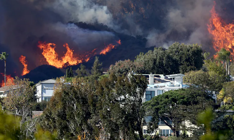
The fires burning in the Los Angeles area are a powerful example of why humans have learned to fear wildfire. Fires can level entire neighborhoods in an instant. They can destroy communities, torch pristine forests and choke even faraway cities with toxic smoke.
Over a century of fire suppression efforts have conditioned Americans to expect wildland firefighters to snuff out fires quickly, even as people build homes deeper into landscapes that regularly burn. But as the LA fires show, and as journalist Nick Mott and I explored in our book “This Is Wildfire: How to Protect Your Home, Yourself, and Your Community in the Age of Heat” and 2021 podcast “Fireline,” this expectation and our society’s relationship with wildfire need to change.
Over time, extensive fire suppression, home construction in high fire-risk areas and climate change have set the stage for the increasingly destructive wildfires we see today.
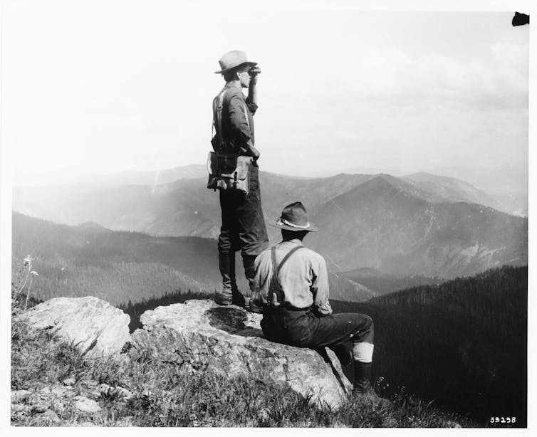
The legacy of fire suppression
The way the U.S. deals with wildfires today dates back to around 1910, when the Great Burn torched about 3 million acres across Washington, Idaho, Montana and British Columbia. After watching the fire’s swift and unstoppable spread, the fledgling U.S. Forest Service developed a military-style apparatus built to eradicate wildfire.
The U.S. got really good at putting out fires. So good that citizens grew to accept fire suppression as something the government simply does.
Today, state, federal and private firefighters deploy across the country when fires break out, along with tankers, bulldozers, helicopters and planes. The Forest Service touts a record of snuffing out 98% of wildfires before they burn 100 acres (40 hectares).
One consequence in a place like Los Angeles is that when a wildfire enters an urban environment, the public expects it to be put out before it causes much damage. But the nation’s wildland firefighting systems aren’t designed for that.
Wildland firefighting tactics, such as digging lines to stop a fire from spreading and steering fires toward natural fuel breaks, don’t work in dense neighborhoods like Pacific Palisades. Aerial water and retardant drops can’t happen when high winds make it unsafe to fly. At the same time, the region’s municipal firefighting forces and water systems weren’t designed for this sort of fire – a conflagration engulfing entire neighborhoods quickly overwhelms the system.
Long ago, Southern California’s scrub-forest ecosystems would periodically burn, limiting fuel for future fires. But aggressive fire suppression and inattention to urban overgrowth have left excessive, easy-to-ignite vegetation in many areas. It’s unclear, however, whether prescribed burning could have prevented this catastrophe.
This is primarily a people problem. People have built more homes and cities in fire-prone areas and done so with little regard for wildfire resilience. And the greenhouse gases released by decades of burning fossil fuels to run power plants, industries and vehicles have caused global temperatures to rise, compounding the threat.
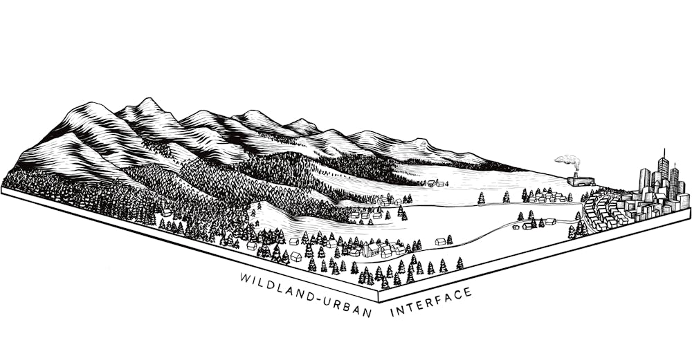
The wildland-urban interface starts on the edges of cities where homes are built closer to forests and grasslands. Courtesy of Jessy Stevenson
Climate change and wildfires
The relationship between climate and wildfire is fairly simple: Higher temperatures lead to more fire. Higher temperatures increase moisture evaporation, drying out plants and soil and making them more likely to burn. When hot, dry winds are blowing, a spark in an already dry area can quickly blow up into dangerous wildfire.
Given the rise in global temperatures that the world has already experienced, much of the western U.S. is actually in a fire deficit because of the practice of suppressing most fires. That means that, based on historical data, we should expect far more fire than we’re actually seeing.
Fortunately, there are things everyone can do to break this cycle.
What fire managers can do
First, everyone can accept that firefighters can’t and shouldn’t put out every low-risk wildfire.
Remote fires that pose little threat to communities and property can breathe life into ecosystems. Frequent, natural fires can also help avoid catastrophic fires that occur when too much underbrush has built up for fuel. And they create fuel breaks on the landscape that could halt the advance of future flames.
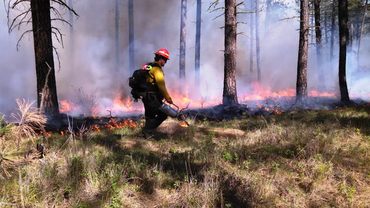
Controlled burns are used to clear out undergrowth that can fuel catastrophic blazes under dry, windy conditions. U.S. Forest Service
Fire managers have advanced mapping technology that can help them decide when and where forests can burn safely. Thoughtful prescribed burning – meaning low-intensity fires intentionally set by professionals – can offer many of the same benefits as the flames that historically burned in forests and grasslands.
The Forest Service is aiming to ramp up its prescribed burning on more acres in more areas across the country. However, the agency struggles to train adequate staff and pay for the projects, and environmental reviews sometimes cause yearslong delays. Other groups offer beacons of hope. Indigenous groups across the country, for example, are returning fire to the landscape.
Adapting homes to fire risk
More than one-third of U.S. homes are in what’s known as the wildland-urban interface – the zone where houses and other structures intermingle with flammable vegetation. This zone now includes many urban areas where wildfire risk was not considered when their cities were developed.
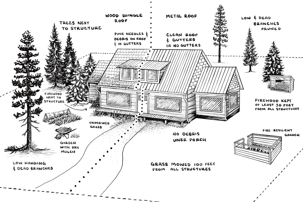
The biggest risk to homes comes from burning embers blowing on the wind and landing in weak spots that can set a house ablaze. Those embers can ride high winds for multiple miles to nestle in dry leaves or pine needles clogging a gutter, a wood-shingle roof, or shrubs, trees and other flammable vegetation close to a structure.
Owning a home in the wildland-urban interface means paying attention to fire risks. Risks are highlighted on the left and solutions on the right. Courtesy of Jessy Stevenson
Some of these vulnerabilities are easy to fix. Cleaning a home’s gutters or trimming back too-close vegetation requires little effort and tools already around the house.
Grant programs exist to help harden homes against wildfire. But enormous investment is needed to get the work done at the scale the fire risk requires. For example, nearly 1 million U.S. homes in wildfire-prone areas have highly combustible wooden roofs. Retrofitting those roofs will cost an estimated US$6 billion, but that investment could save lives and property and reduce wildfire management costs in the future.
Homeowners can look to resources such as Firewise USA to learn about the “home ignition zone.” It describes the types of vegetation and other flammable objects that become high risks at different distances from a structure and steps to make properties more fire resilient. https://www.youtube.com/embed/M9sel3wcBLg?wmode=transparent&start=0 The fire chief for Spokane, Wash., explains ways to protect your property from wildfires.
For example, homes should not have flammable plants, firewood, dried leaves or needles, or anything burnable, on or under decks and porches within 5 feet (1.5 meters) of the house. Between 5 and 30 feet (9 meters), grasses should be mowed short, and the tree canopy should be at least 10 feet (3 meters) from the structure.
The key takeaway is that homeowners must begin to view their homes as potential fuel for a wildfire.
Rebuilding right
A possible outcome of California’s devastating fires is that states and communities could enact forward-looking wildfire resilience policies. These can include developing zoning rules and regulations that require developers to build with fire-resistant materials and designs. Or they might prohibit building in areas where the risk is too high.
California’s move to fast-track reconstruction, if it isn’t planned with wildfire safety requirements, will just set up the state for more fire disasters. The International Wildland-Urban Interface Code, which provides guidance for safeguarding homes and communities from wildfire, has been adopted in jurisdictions in at least 24 states. California is not one of them.
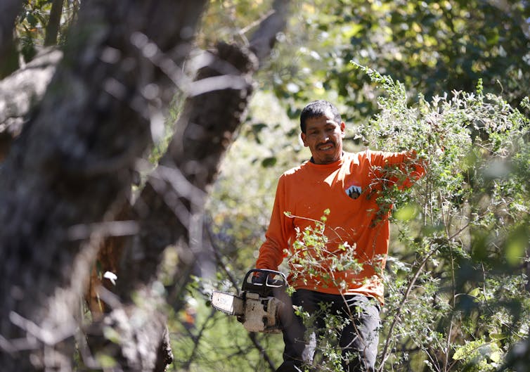
Protecting homes from wildfires includes maintaining a safe perimeter clear of potential fuel for a fire. Justin Sullivan/Getty Images
Living in a world with wildfire
Prevention and suppression will always be critical pieces of wildfire strategy. Though promising new firefighting technologies are being developed, adapting to a fiery future means everyone has a role.
Educate yourself on how wildfire is managed in your area. Understand and address risks to your home and community. Help your neighbors. Advocate for better wildfire planning, policy and resources.
Living in a world where more wildfire is inevitable requires that everyone see themselves as part of solving the problem. It means we must accept that some fire is natural and essential and that some places we love might be too dangerous to protect.


.jpg)