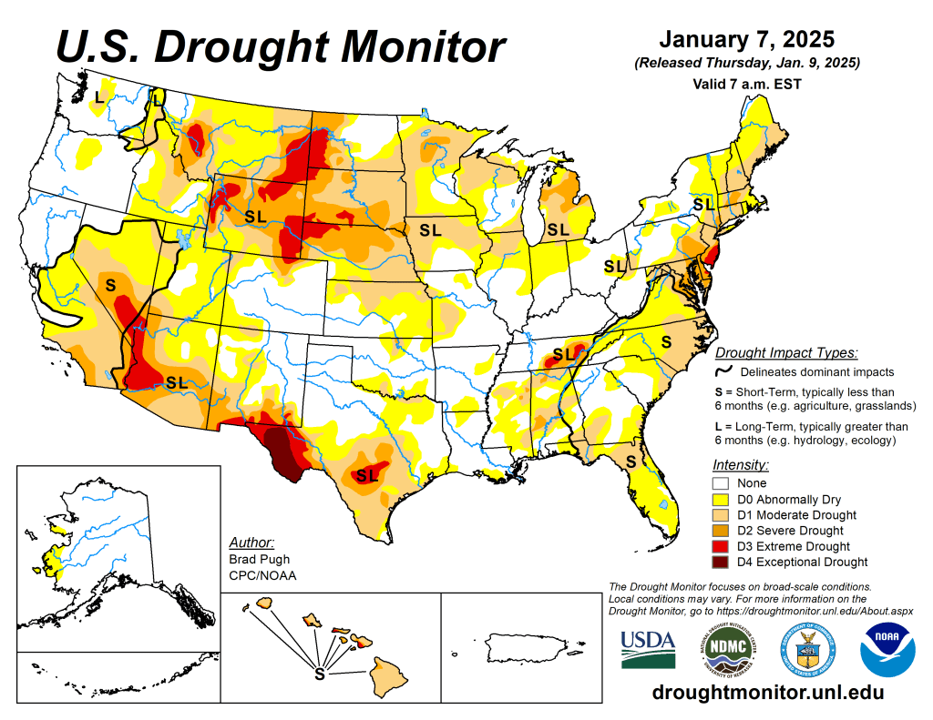
On January 4 and 5, a low pressure system developed across the Central Great Plains and then tracked eastward to the Mid-Atlantic. Along its track, widespread precipitation (1 to 2 inches, liquid equivalent) was observed throughout eastern Kansas, Missouri, the Ohio and Tennessee Valleys, Central Appalachians, and Mid-Atlantic. Total snowfall amounts were near or more than a foot in portions of these areas. This winter storm also resulted in freezing rain for the Ohio Valley and parts of Virginia and West Virginia. Drought improvements were generally made to portions of the central and eastern U.S. where precipitation amounts exceeded 1 or 1.5 inches, liquid equivalent. Drought coverage and intensity continued its decline for the Upper Ohio Valley and New England. After the winter storm exited the East Coast, an arctic air outbreak overspread the eastern two-thirds of the lower 48 states. A favorable start to the wet season coupled with above-normal snowpack supported a decrease in drought coverage across the Pacific Northwest. Conversely, drought worsened for southern California and the Southwest. Alaska and Puerto Rico remained drought-free, while short-term drought intensified across Hawaii…
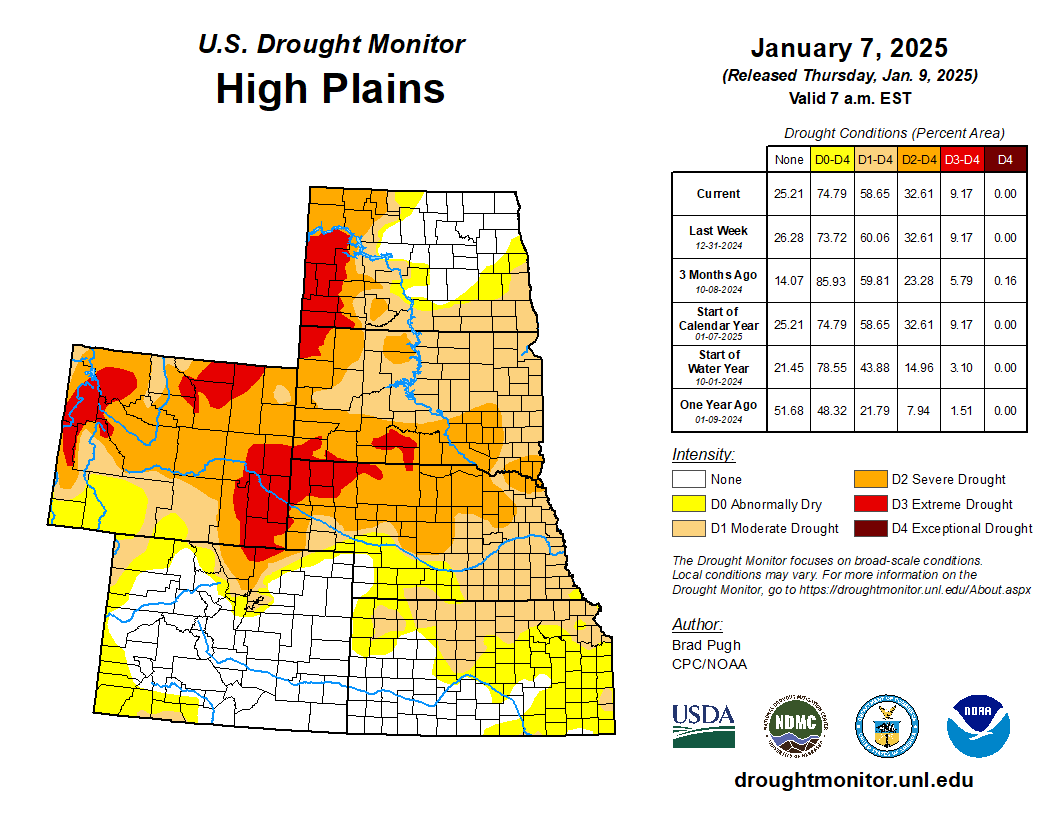
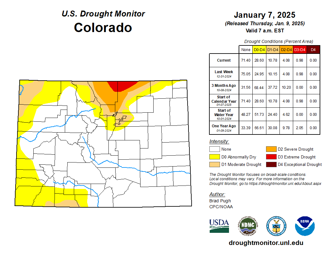
Based on 30 to 60-day SPI along with a lack of early season snowpack, a 1-category degradation was made to southwestern Colorado. Farther to the north across northwestern Colorado, improving snowpack resulted in a minor reduction in abnormal dryness (D0). Southwestern Nebraska has received little to no precipitation during the past 7 weeks, prompting an expansion of D0. In addition, above-normal temperatures during the late fall and into the early winter exacerbated increasing short-term dryness. Heavy precipitation (more than 1 inch, liquid equivalent) for this time of year resulted in a 1-category improvement to northeastern Kansas. No changes were made to the Dakotas and early January is one of the driest times of the year…
Colorado Drought Monitor one week change map ending January 7, 2025.
A dry start to the winter and using 90-day SPI and soil moisture, moderate drought (D1) was expanded across southern California. The NDMC short-term blend, 90-day SPI, and many 28-day average streamflows below the 10th percentile supported the addition of severe drought (D2) to portions of southern California. The Santa Ana winds during early January are likely to exacerbate the worsening drought conditions. Consistent with the NDMC short-term blend along with 30 to 120-day SPI, D2 was expanded for portions of southeastern Arizona and southwestern New Mexico. Based on water year to date (WYTD: October 1, 2024 to January 6, 2025) precipitation averaging above normal and snow water equivalent (SWE) above the 80th percentile, a 1-category improvement was made to southwestern Idaho, eastern to central Oregon, eastern Washington and a small part of northwestern Montana. This 1-category improvement is also supported by NDMC drought blends and SPIs at various time scales. As of January 7, SWE was above-normal (period of record: 1991-2020) across the southern Cascades along with eastern Oregon and southwestern Idaho. SWE was highly variable for the Sierra Nevada Mountains and below-normal across the Four Corners Region…
Based on 30 to 120-day SPI, 28-day streamflow, and soil moisture, a 1-category degradation was made to portions of the Edwards Plateau of Texas. SPIs at various time scales and soil moisture supported a 1-category degradation as well for parts of the Rio Grande Valley. Heavy rainfall during late December supported additional improvements across southeastern Texas. Recent rainfall (1 to 2 inches) prompted a 1-category improvement to parts of Mississippi and Tennessee. Despite the recent rainfall, 28-day average streamflow and 90-day SPI support a continuation of D1-D3 intensity for the Tennessee Valley. Although precipitation was lighter this past week, the lack of any support among the indicators for D0 and D1 led to improvements to much of Arkansas…
Looking Ahead
A low pressure system is forecast to develop along the western Gulf Coast by January 10 with a rapid eastward track offshore of the Mid-Atlantic one day later. A large area of 1 to 2.5 inches of rainfall is expected for eastern Texas and the Lower Mississippi Valley, while accumulating snow occurs from the southern Plains east to the Tennessee Valley and Southern Appalachians. High elevation snow is forecast to shift east from the Cascades to the northern Rockies on January 10 and 11. Farther south across California, dry weather is likely to persist through mid-January. On January 13, another Arctic high is forecast to shift south from Canada to the Great Plains.
The Climate Prediction Center’s 6-10 day outlook (valid January 14-18, 2025) favors below-normal temperatures for a majority of the lower 48 states. The largest below-normal temperature probabilities (exceeding 80 percent) are forecast for the Southeast. An increased chance of above-normal temperatures is limited to the Dakotas and Minnesota. Below-normal precipitation is most likely across the Pacific Northwest, Great Basin, and much of California. Elevated above-normal precipitation probabilities are forecast for the Southwest, Texas, and High Plains, while below-normal precipitation is slightly favored along the East Coast.
US Drought Monitor one week change map ending January 7, 2025.
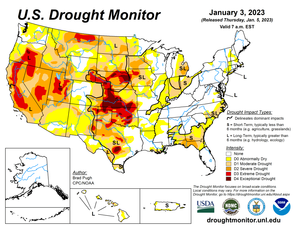
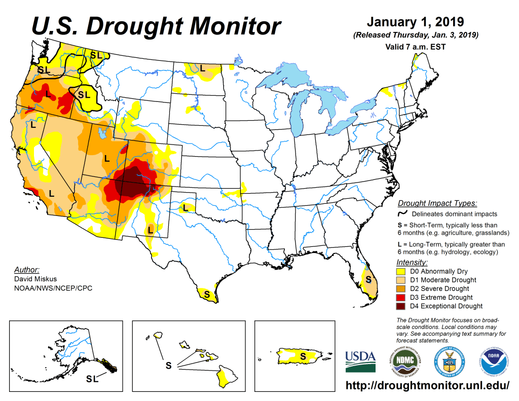
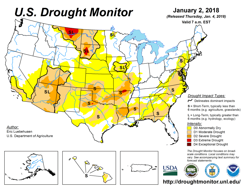
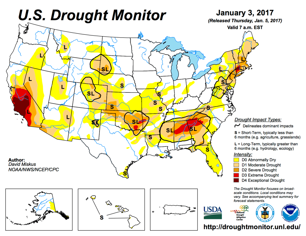
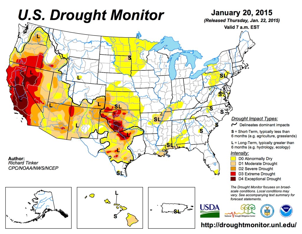
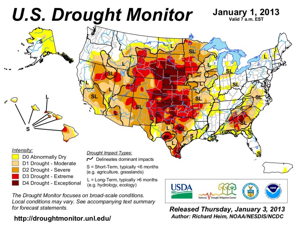
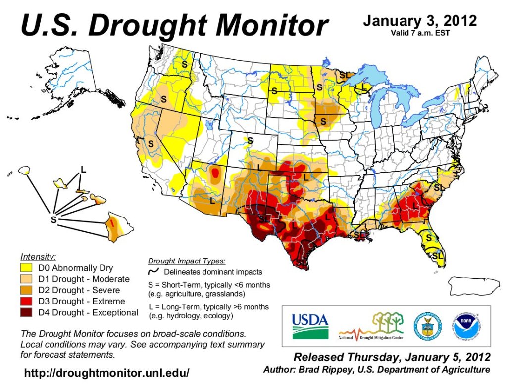
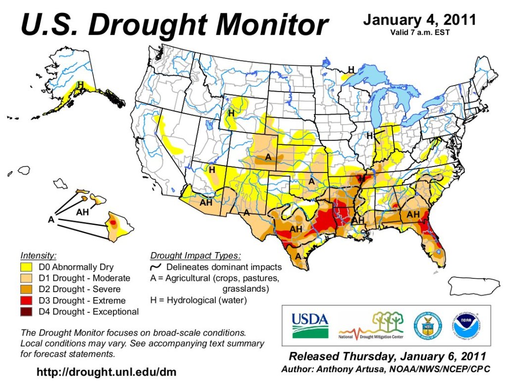
Just for grins here’s a slideshow of early January US Drought Monitor maps for the past few years.
After years of demanding the cleanup of uranium waste at the Kerr-McGee Quivira Mines on the Navajo Nation community advocates got the news this week that the Environmental Protection Agency will remove waste rock from three areas of the site and move it to a new off-site repository. The removal of over 1 million cubic yards of radioactive waste from the sites about 20 miles northeast of Gallup will begin in early 2025, the EPA said. The waste will be taken to a new off-site repository at Red Rocks Landfill east of Thoreau, N.M. The process, including permitting, construction, operation and closure of the repository, is expected to take 6-8 years.
“I feel as though our community finally has something of a win,” said Teracita Keyanna, a member of the executive committee for Red Water Pond Road Community Association. “Removing the mine waste from our community will protect our health and finally put us back on a positive track to Hózhǫ.”
Commercial exploration, development, and mining of uranium at Quivira Mines began in the late 1960s by the Kerr-McGee Corporation and later its subsidiary. The mine sites are the former Church Rock 1 (CR-1) mining area; the former Church Rock 1 East (CR-1E) mining area; and the Kerr-McGee Ponds area. The mines were in operation from 1974 to the mid-1980s and had produced about 1.2 million tons of ore, making them among the 10 highest producing mines on the Navajo Nation…From World War II until 1971, the U.S. government was the sole purchaser of uranium ore, driving extensive mining operations primarily in the southwestern United States. These efforts employed many Native Americans and others in mines and mills. Between 1944 and 1986, nearly 30 million tons of uranium ore were extracted from Navajo lands under leases with the Navajo Nation. With over 500 abandoned uranium mines — many say the total could be in the thousands — clean up of mines has always been a battle.
Reclamation Commissioner Camille Calimlim Touton greets several members of the Southeastern
District Board, from left, Bill Long, Kevin Karney, Howard “Bub” Miller, Andy Colosimo and Justin
DiSanti. Photo credit: Southeastern Colorado Water Conservancy District
January 8, 2025
Camille Calimlim Touton, Commissioner of the U.S. Bureau of Reclamation, traveled to Pueblo on Wednesday, January 8, to announce an additional $250 million for construction of the Arkansas Valley Conduit.
“We are proud to see the work underway because of President Biden’s Investing in America agenda,” Commissioner Touton said. “But there’s much more work to be done and we are again investing in this important project to bring safe drinking water to an estimated 50,000 people in 39 rural communities along the Arkansas River.”
The $250 million is funded through the Bipartisan Infrastructure Law and is part of a $514 package of water infrastructure investments throughout the western United States under the BIL.
The additional funding brings the total federal investment in the AVC to almost $590 million since 2020, along with state funding guarantees of $90 million in loans and $30 million in grants.
“After 25 years, I still almost can’t believe it’s happening, but I drive by and can see it with my own eyes,” Southeastern Water Conservancy District President Bill Long told Commissioner Touton. “There are so many people who have worked so hard who would be so proud to see it being built. This money will get us to the area that has seen the most problems.”
The Southeastern District is the sponsor for the AVC, which is part of the 1962 Fryingpan-Arkansas Project Act. The 130-mile pipeline to Lamar will bring water to 50,000 people being served by 39 water systems when complete.
Several Southeastern Board members attended Wednesday’s announcement.
“You and your team are the ones who have gotten this off the ground,” said Kevin Karney, a La Junta rancher, and at-large Board member.
“People said it would never get built, but now we’re getting it done,” said Howard “Bub” Miller, who represents Otero County on the Board.
The AVC will help 18 water systems that face enforcement action for naturally occurring radionuclides in their groundwater supplies, as well as communities struggling to meet drinking water and wastewater discharge standards.
Construction of the AVC began in 2023, and three major construction contracts have been awarded.
“This money really gets us further down the valley. It is very much appreciated,” Long said.
Hickenlooper, Bennet Welcome Additional $250 Million for Ark Valley Conduit
Funding awarded from the senators’ Bipartisan Infrastructure Law
In total, Hickenlooper and Bennet have helped secure $500 million in funding for the project
WASHINGTON – Today, Colorado U.S. Senators John Hickenlooper and Michael Bennet welcomed the Bureau of Reclamation (BOR)’s announcement of $250 million in new funding from the Bipartisan Infrastructure Law for continued construction of the Arkansas Valley Conduit (AVC).
“We passed the Bipartisan Infrastructure Law to finally deliver on promises to rural communities,” said Hickenlooper. “In Colorado that means finishing the long-awaited Ark Valley Conduit and bringing clean, reliable drinking water to 50,000 people.”
“For decades, I’ve worked to secure investments and pass legislation to ensure the federal government keeps its word and finishes the Arkansas Valley Conduit,” said Bennet. “This major Bipartisan Infrastructure Law investment will be critical to get this project across the finish line to provide safe, clean water to tens of thousands of Coloradans along the Arkansas River.”
John F. Kennedy at Commemoration of Fryingpan Arkansas Project in Pueblo, circa 1962.
The AVC is a planned 130-mile water-delivery system from the Pueblo Reservoir to communities throughout the Arkansas River Valley in Southeast Colorado. This funding will continue ongoing construction. The AVC is the final phase of the Fryingpan-Arkansas Project, which Congress authorized in 1962.
Hickenlooper and Bennet have consistently and successfully advocated for increased funding for the AVC. Last year, Hickenlooper and Bennet wrote to President Biden to urge him to prioritize funding for the AVC in his fiscal year 2025 budget. The senators also called on Senate Appropriations leaders to provide more funding for the project. In January 2023, Hickenlooper and Bennet urged BOR to allocate additional resources through annual appropriations and Bipartisan Infrastructure Law funding.
As a result of their efforts, the senators have helped deliver $500 million from the Bipartisan Infrastructure Law for the AVC, including $90 million in 2024, $100 million in 2023, and $60 million in 2022. They also secured an additional $10.1 million in fiscal year 2024 and $10.1 million in fiscal year 2023 through the annual government funding bills.
More information on the funding is available HERE.
Arkansas Valley Conduit map via the Southeastern Colorado Water Conservancy District (Chris Woodka) June 2021.
Graphic credit: The Colorado River water crisis its origin and future Jock Schmidt, Eric Kuhn, Charles Yackulic.
January 7, 2025
Belated season’s greetings, dear readers! The season being the long dark days as our turning planet slowly tilts our part of the planet again toward the star we circle – moving us into a new year-cycle that will probably again be ‘one of the ten warmest years in recorded climate history’ – if not ‘the warmest’ again.
But we are officially no longer going to be concerned about that, right? The voters have spoken, with the usual one-percent victory taken by the winner to be a landslide mandate. And what the voters decided, by that one-percent margin, is that we, as a nation, the Untied States of America, shall officially cease to believe that we are changing the climate; we’ve given ourselves license to linger in the denial and anger stages – denial that it is happening, and anger at anyone who wants to blame us for that which we can now officially refuse to believe is happening.
And we will not just lie back leisurely, relaxing in our denial, doing nothing about what we believe is not happening. No, we are going to try to break all previous production records of those fossil fuels that we can now officially refuse to believe are changing the climate – yes, even coal too, to shovel into the industrial juggernaut, which will grow as all those factories that moved overseas will sheepishly return home, once the tariffs are working their magic in bending the rest of the world to our will…. We are promised this will be the official national Reality According To Trump (RATT).
Meanwhile, however, back along the Colorado River, it is a little harder to make the RATT logic compute. The sequence of successively warmer years has had an undeniable, measurable, negative impact on our usable water supply: something like a 5-7 percent loss of surface water for every degree of rise in the annual average temperatures. It’s not necessarily that there’s less water; it’s just that more of the water is shifting into the uncontrollable vapor state rather than the manageable liquid state we earthlings need. The bottom line is a measurably diminishing supply, over the past several decades, of the surface water on which 35 million city dwellers and the irrigators of five million acres of desert land depend to some degree.
Udall/Overpeck 4-panel Figure Colorado River temperature/precipitation/natural flows with trend. Lake Mead and Lake Powell storage. Updated through Water Year 2024. Credit: Brad Udall
Where are we right now with the management planning process for the river? In mid-November 2024, the Bureau of Reclamation issued five mix-and-match alternatives for managing the Colorado River in the future – meaning the decade or so beyond the 2026 expiration of the 2007 Interim Guidelines (and the 2019 Interim Interim Guidelines, and the 2023 Interim Interim Interim Guidelines).
These alternatives are the Bureau’s effort to break the stalemate in the stalled negotiations between the four states of the Upper Colorado River Basin and the three states of the Lower Colorado River Basin. Large cuts in use will be necessary to keep the storage and distribution systems operational, and each Basin wants the other Basin to take a larger share of those cuts proscribed by ‘the river we have, not the river we dream for,’ as Colorado’s chief negotiator Becky Mitchell put it. (See the graphic at the beginning.)
The Bureau’s five alternatives, for which they plan to do the required Environmental Impact analysis this year, all focus primarily on managing the two main reservoirs, Mead and Powell, although other reservoirs in the system may by used to bolster storage in the two big ones. The five alternatives run a gamut from the NEPA mandatory ‘No Action’ alternative (continue business as usual), through two varying levels of federal management if the states are unable to reach a working agreement, to an alternative based primarily on a plan submitted by conservation groups, to a final alternative that is mostly pieced together from the conflicting plans proposed by the two basins, assuming the two basins can find the necessary compromises to make the two plans into one plan that might work.
Native America in the Colorado River Basin. Credit: USBR
All alternatives except the one by conservationists (#4) include notice that ‘there would be explicit accounting of unused/undeveloped quantified Tribal water.’ This means that the settled or decreed water rights of the First Peoples would finally be acknowledged in the river accounting, noting where and by whom their undeveloped water was being used – the first step, as one tribal member observed, in eventually either getting the water back for their own use, or getting paid by others for the continued use of their water. The First People are getting closer to being at the table. (It is worth noting that the Gila River Indian Community, south of Phoenix, is the first user organization to sign a post-2026 contract with the Bureau to leave some of its water in Mead Reservoir, water that will be conserved through projects to be funded with infrastructure money, if that survives the RATT.)
That is the broad overview; if you wish for more specifics, you can find more detailed descriptions of all five alternatives here, but there is probably no real need for us citizens to get down in the weeds of detail just yet, since we are just passive participants at that level anyway.
Instead, I want to encourage us to think on the larger level of considering alternatives not part of the Bureau’s five choices. Why not? There is, after all, a large minority of us who do not drink the small majority’s RATT kool-aid. For those of you who fit that description, my season’s greeting to you are two quotations I encountered recently that kind of rang my bell:
The first is a poet calling for poets to ‘give us imagination of peace, to oust the intense, familiar imagination of disaster.’ ‘Peace’ is given the negative-space definition of ‘not only the absence of war’: something more, or other, than mere truce. The ‘familiar imagination of disaster,’ on the other hand, is a major element of the RATT: a nation overrun by immigrant murderers, inflation out of control, an economy gone to hell, cities awash in crime, et cetera – that’s the virulent and violent imaginings that became the principal election strategy of the Repugnicans (as distinguished from the real but very timid Republicans). They call it ‘flooding the zone with shit,’ so much imagining of fictitious disaster that one wave of lies cannot be seriously addressed and challenged before the next wave rolls over us. This was a successful campaign strategy, with the naive cooperation of the national media serving as their trumpet: when the fact meets the RATT, print the RATT – reserving the last couple paragraphs for quotes citing the facts that contradict the RATT, thus it’s fair and balanced!
But when we come to our river – how are the poets to ‘imagine the peace’? And the call for poets does not necessarily preclude the hydrologists, politicians, water managers and others who manage ‘the river we have.’ Just to say, for example, as Becky Mitchell said, ‘We need to plan for the river we have, not the river we dream for,’ moves the discourse into the poet’s realm of analogy and metaphor, not denying but augmenting the scientist’s world of evidential causation and consequence, en route to testable hypotheses.
The second quote, however, by the author of 1984 – the book describing the fully devolved RATT worldview that we are flirting with now – cautions us that ‘the imagination, like certain wild animals, will not breed in captivity.’ Is that same as saying the realm of the imagination lies in ‘thinking outside the box’? Like we keep saying we need to be doing?
Well, moving forward with that assumption – Orwell seems to be suggesting that the imagination can’t kick into gear if we are, consciously or unconsciously, holding it ‘in captivity’ inside some box of dominant conventional weltanschauung – ‘world view’ in translation, ideology, or just ‘our way of doing things.’ But the word is so much more heavily evocative in German of the mass and weight of the box, the height of the sidewalls that discouraging climbing up to look over and beyond…. Orwell was aware of the flywheel power of the boxes a society builds around itself – and the extent to which that power depends on the unquestioning, often only semi-conscious, acceptance of those who dwell within the box as ‘the way it is and that’s it.’ Even if ‘the way it is’ is not that great.
That would suggest that unleashing our imagination to such tasks as the ‘imagination of peace,’ even just regional peace along a modest and shrinking desert river, has to begin by becoming aware of the box that we need to be trying to think outside of.
What I think we have in the Colorado River region are at least two nested boxes. Whenever we hear someone intone, ‘The foundation of the Law of the River is the Colorado River Compact,’ or, ‘The Colorado River Compact cannot be (tinkered with, changed to fit reality, or discarded as irrelevant),’ we can assume that their imagination is held captive in the Colorado River Compact Box. When Becky Mitchell says, ‘We have to plan for the river we have, not the river we dream for,’ she has at least hiked herself up onto the edge of the Compact Box – a Compact that was written for a mythic river half-again larger than the river we have now. She might even be looking beyond the Compact for resolution (although she can probably not say that out loud yet).
Prior appropriation example via Oregon.gov
If we hike ourselves up onto the edge of Compact Box, we will find ourselves looking at a larger and more intimidating box: the Prior Appropriation Box. This, not the Compact, is clearly the ‘foundation’ of all law regarding the use of the river: first come, first served, and seniority rules. All seven of the Colorado River states had embraced the Appropriation Doctrine as the foundation of their water law by the early 20th century. (New Mexico and Arizona did not become states until 1912.)
But those of us captive in the Compact Box tend to forget that the Compact Commission came together in 1922 to try to override the appropriation doctrine at the interstate level, among the seven states. California was growing so fast, with Arizona not far behind, that the high desert and mountain states above the river’s canyon region – growing much more slowly due to the erratic ebb and flow of the mining industry – feared there would be no unappropriated water left when they hit their stride. And none of the states really wanted a seven-state horserace of helter-skelter ‘defensive appropriation’ to avoid being left high and dry.
The water managers in the states also knew that the only way to ‘civilize’ the Colorado River was to control and store the annual spring flood of mountain snowmelt, for release as needed throughout the rest of the year. And because it was an interstate river, and because the cost of big mainstream structures was beyond their means, they knew the federal government, through its Bureau of Reclamation, would have to take a lead role in that regional development. But what they did not want was for the feds to take over all the development and operation of ‘their’ river’s water.
Members of the Colorado River Commission, in Santa Fe in 1922, after signing the Colorado River Compact. From left, W. S. Norviel (Arizona), Delph E. Carpenter (Colorado), Herbert Hoover (Secretary of Commerce and Chairman of Commission), R. E. Caldwell (Utah), Clarence C. Stetson (Executive Secretary of Commission), Stephen B. Davis, Jr. (New Mexico), Frank C. Emerson (Wyoming), W. F. McClure (California), and James G. Scrugham (Nevada)
CREDIT: COLORADO STATE UNIVERSITY WATER RESOURCES ARCHIVE via Aspen Journalism
So the Compact Commission assembled in January of 1922 to develop an interstate compact that would ‘provide for the equitable division and apportionment of the use of the waters of the Colorado River System’ – a seven-way division of the waters to give each state the right to use, in its own good time, the water needed to develop its land and resources. When a state was ready to use it, their share of the river’s water would be there for them, protected from prior appropriation by other faster-growing states.
That was the vision anyway: the ‘Compact Box’ nested in the ‘Prior Appropriation Box’ was to be an interstate refuge from the prior appropriation doctrine. ‘First come, first served’ could by the law within the states – but only up to the quantity allotted for each state.
They failed to realize that vision, however, after several days of trying – mostly for reasons of vagueness about, first, the flow of the river itself, and second, their own over-optimistic estimates of their own futures. Only the persuasive power of the federal representative on the Commission, Herbert Hoover – an engineer by training who really wanted to see the big mainstream structures built – kept them on task until they patched together, ten months later, the two-basin division for the use of the river’s water.
That substitute division was immediately rejected by the State of Arizona, and is now clearly failing at its original intent to transcend the appropriation doctrine between states: California is applying the prior appropriation doctrine against the other states in the Lower River Basin (as Arizona knew they would eventually). And the Lower Basin is threatening ‘Compact calls’ against the Upper Basin states if they do not get their 75 million acre-feet over any ten-year period as defined in Article III(d) of the Compact, as though the division into two basins had given them a big ‘prior appropriation.’
The ‘Compact Box’ is basically just a ‘shadow box,’ a failed effort to do what was really a pretty good idea – an imagination of peace among the states. The question now is: would it be possible to revive that idea of an ‘equitable division’ among the seven states – as something that is already somewhat accomplished? That’s a thread we’ll pluck at next post.
Map of the Colorado River drainage basin, created using USGS data. By Shannon1 Creative Commons Attribution-Share Alike 4.0