Understanding Dominant Forces in LA’s Palisades, Eaton & Other Fast Fires Through Earth Science Data: “These types of fires are impossible to stop” — Ralph Bloemers

Onlookers watching the fire from the Columbia River Gorge, September 4, 2017. By U.S. Forest Service – https://inciweb.nwcg.gov/incident/photographs/5584/, Public Domain, https://commons.wikimedia.org/w/index.php?curid=62215007

Click the link to watch the video on YouTube:

Jan 10, 2025

Key takeaways:

● Researchers used NASA satellite data to analyze the growth rates of over 60,000 fires in the contiguous U.S. from 2001-2020

● Results show fast-growing fires caused 88 percent of fire-related damages in the U.S. between 2001-2020 despite representing less than 3 percent of fires on record during that time.

Fast-growing fires were relatively rare in the United States between 2001-2020, yet they were responsible for nearly 90 percent of fire-related damages, according to a new study published in Science and featured in a new episode of PBS Weathered. These wind events with fire in them send embers far ahead of advancing flames, jump over rivers and highways and rapidly ignite homes. These fast fires overwhelm suppression response. The groundbreaking research relied on new remote sensing tools and shows these fires are getting faster in the Western U.S., increasing the risk for millions of people, and highlighting the actions we need to take before fire comes. “We hear a lot about megafires because of their size, but if we want to protect our homes and communities, we really need to appreciate and prepare for how fast fires move,” said Jennifer Balch, fire scientist and the lead author of the study. “Speed matters not only for understanding how fires evolve but also for keeping people safe.” NASA worked with Navteca to create scientifically accurate, time-based animations of several fast fires, including:

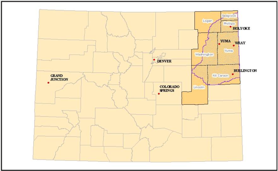
  • The East Troublesome fire, which destroyed hundreds of homes in and around Grand Lake in the Colorado Rockies, raced over 18 miles in a single day and jumped the barren Continental Divide,
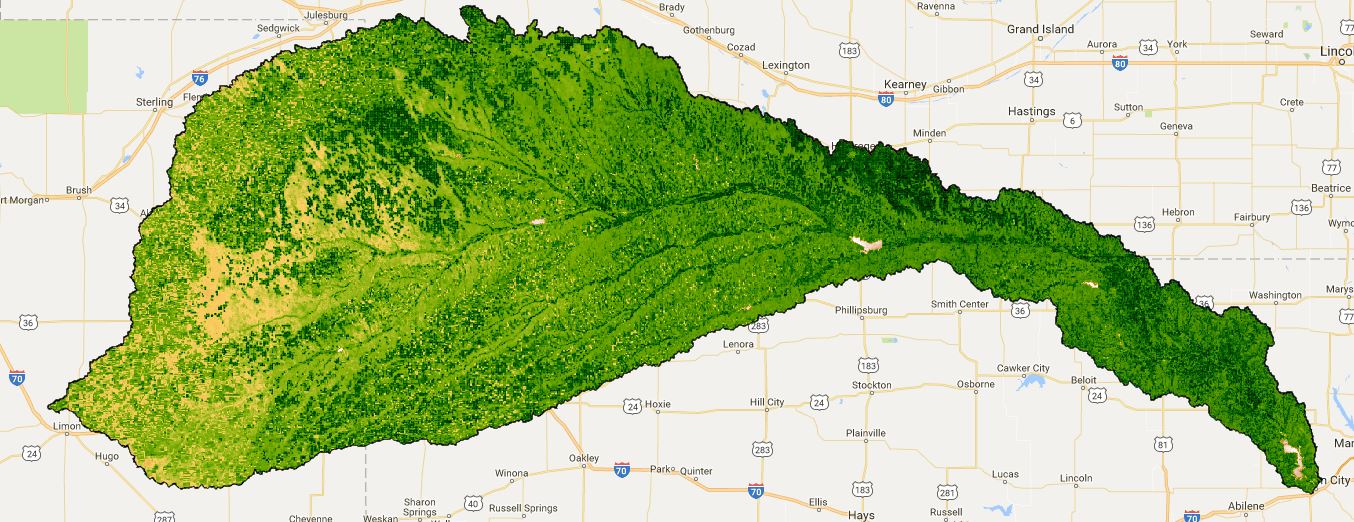
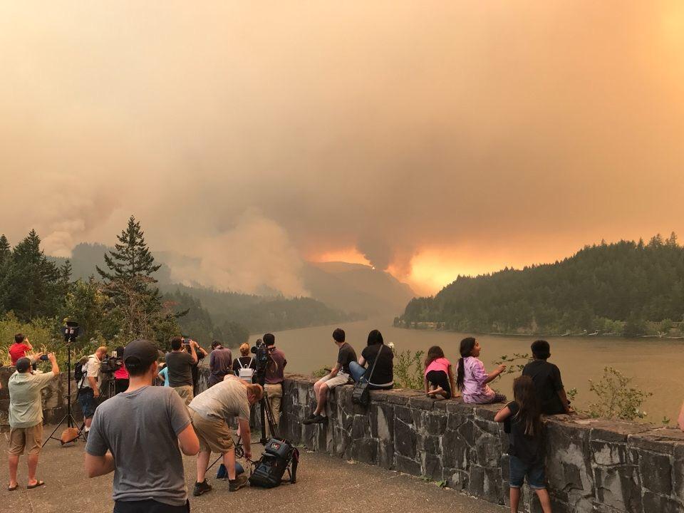
  • The 2020 Labor Day fires in Oregon and Washington, where a statewide 2,000 foot deep river of wind flowed down from the interior of North America, knocking down power lines and fanning existing fires into rapidly growing fires that burned communities across Oregon,
  • The Marshall Fire, which destroyed more than 1,000 homes in Boulder County, Colorado, in December 2021. The fire burned less than 6,100 acres but grew quickly due to a combination of dry conditions and high winds. Less than an hour after the fire was reported, it had spread to a town 3 miles away, forcing tens of thousands of people to evacuate, and
  • The Lahaina Fire which burned 2,170 acres, destroyed 2,285 structures (mostly residential) and killed 98 people. The fire was driven by sustained winds of 30 mph with gusts doubling that.

Fast fires grew more than 4,000 acres (more than 6 square miles) in a single day. The analysis revealed a staggering 250 percent increase in the average maximum growth rate of the fastest fires over the last two decades in the Western U.S. U.S. Fire Administrator Dr. Lori Moore-Merrell reflected: “This research helps us focus our attention on what causes the most loss and what we can do to prepare before fire comes to make us savable.” Fast fires accounted for 88 percent of the homes destroyed between 2001 and 2020 despite only representing 2.7 percent of fires in the record. Fires that damaged or destroyed more than 100 structures exhibited peak fire growth rates of more than 21,000 acres (more than 32 square miles) in a single day. The work also highlights a critical risk assessment gap. At the national level, wildfire risk models include parameters for area burned, intensity, severity, and probability of occurrence, but they do not incorporate growth rate or other measures of fire speed. Government agencies and insurance companies that use these models are therefore missing vital information about how fires spread, which homeowners could use to better protect themselves and their communities. “When it comes to safeguarding infrastructure and orchestrating efficient evacuations, our satellites and earth observations are telling us that the speed of a fire’s growth is a dominant factor in home and community loss.” Dr. Falkowski, Director of NASA’s wildland fire program said.

The East Troublesome fire as it tore through the Trail Creek Estates subdivision on Oct. 21, 2020. (Brian White, Grand Fire Protection District)

Report details the state’s ‘meaningful’ progress getting more water to the #GreatSaltLake —  Kyle Dunphey (#Utah News Dispatch) #aridification

The shores of the Great Salt Lake near Syracuse are pictured on Tuesday, May 21, 2024. (Photo by Spenser Heaps for Utah News Dispatch)

Click the link to read the article on the Utah News-Dispatch website (Kyle Dunphey):

January 15, 2025

For the last several years, Utah’s lawmakers and environmental officials have made getting water to the Great Salt Lake a priority, through policies like letting the state lease water rights from farmers, or installing new equipment to measure water flows. 

Now, a new report details the progress and impacts some of those policies are having, calling the work done so far “meaningful.” 

On Tuesday, the Great Salt Lake Strike Team issued its 2025 data and insights summary, released just in time for lawmakers to review for the upcoming General Legislative Session, which starts next week.

The Great Salt Lake hit a historic low in 2022, bottoming out at 4,188.5 feet. Lawmakers and state officials prioritized the lake that following legislative session — then the winters of 2023 and 2024 brought above-average snowfall, causing the lake levels to rebound slightly. On Wednesday, both the north and south arms hovered around 4,192 feet, still several feet below the “ecologically healthy” level of 4,198 feet. 

Formed in 2023, the Great Salt Lake Strike Team is made up of researchers from the University of Utah and Utah State University, working with officials from the Utah departments of Natural Resources, Agriculture and Food, Environmental Quality and more. 

The data-heavy 28-page report released this week outlines everything from the economic benefit of the Great Salt Lake, to locations of the dust “hotspots” on the dry lakebed that pose a health risk to the Wasatch Front, to models for future scenarios, and more.

The shores of the Great Salt Lake near Antelope Island are pictured on Tuesday, May 21, 2024. (Photo by Spenser Heaps for Utah News Dispatch)

The report also details some of the progress made in the last year that delivered more water to the lake. Consider this:

  • More than 288,000 acre-feet of water has been approved to flow to the lake, through users either leasing or donating their water right to the state. That’s enough water to fill both Jordanelle and Rockport reservoirs, although the report notes that’s just what’s been approved, and doesn’t represent the actual amount of water that’s been delivered. 
  • The Legislature is spending $1 million in one-time funds and $1 million in annual funds to install measurement infrastructure so the Utah Division of Water Rights can see exactly how much water is flowing to the lake. An additional $3 million from the U.S. Bureau of Reclamation and U.S. Geological Survey is also going toward measurement equipment. 
  • In addition to funding for water monitoring, state and federal governments have thrown nearly $100 million at the lake for various projects, including $50 million from the U.S. Bureau of Reclamation for conservation; $5.4 million from the state for wetland conservation; $22 million from the state for Great Salt Lake water infrastructure projects; $15 million from the state to the Great Salt Lake Commissioner’s Office to help lease water; and $1.5 million to start a state-funded study exploring ways to deliver more water from Utah Lake to the Great Salt Lake.
  • Compass Minerals and Morton Salt, which both operate on the lake, donated a total of 255,298 acre-feet of water to the state. Compass Minerals is also relinquishing about 65,000 acres of leased land to the state for conservation purposes. 
  • Lawmakers in 2024 passed a number of bills to help the lake, including tightened regulations and taxes on mineral extraction, allowing agricultural water users to sell leased water and restricting the use of overhead sprinklers for new government construction in the Great Salt Lake Basin. 
  • There have also been some environmental wins. Brine shrimp populations are rebounding, with a 50% increase in egg numbers compared to last year. American white pelicans returned to their nesting sites on the lake. And the state removed 15,600 acres of phragmites, an invasive plant.

The report notes that the state has made “meaningful progress.” And while it clarifies that the report is purely data-focused and doesn’t make policy recommendations, it does lay out “potential policy levers.” 

An American avocet is pictured at the Great Salt Lake near Antelope Island on Tuesday, May 21, 2024. (Photo by Spenser Heaps for Utah News Dispatch)

That includes greater incentives for water leasing. The state made several new options available for water right holders, including letting farmers lease water for a portion of the year, water banking (which gives water users more flexibility over leasing agreements) and applications allowing users to quantify water saved through optimization projects. 

But according to the report, the state hasn’t yet received any applications for these three programs. 

The Utah Legislature also recently subsidized the installation of secondary water meters, so water districts know how much they’re using — those meters are often associated with water savings. The report recommends water districts in the Great Salt Lake Basin donate or lease that saved water for the lake. 

“All indications demonstrate that delivering more water to the lake is a far more cost-effective solution than managing the impacts of a lake at a perpetually low level,” said Brian Steed, the co-chair of the strike team and Great Salt Lake Commissioner. “We can invest time and financial resources now or pay much later. Fortunately, we have great data and a balanced and workable plan to succeed.”

Sunset from the western shore of Antelope Island State Park, Great Salt Lake, Utah, United States.. Sunset viewed from White Rock Bay, on the western shore of Antelope Island. Carrington Island is visible in the distance. By Ccmdav – Own work, Public Domain, https://commons.wikimedia.org/w/index.php?curid=2032320

Water-short #RepublicanRiver Basin hits farm dry-up milestone, as #Kansas looks on — Jerd Smith (Fresh Water News)

Republican River in Colorado January 2023 near the Nebraska border. Photo credit: Allen Best/Big Pivots

Click the link to read the article on the Water Education Colorado website (Jerd Smith):

January 16, 2025

Farm communities on the Eastern Plains, under the gun to deliver water to Kansas and Nebraska, are poised to permanently retire 17,000 acres of land, with the help of $30 million in state and federal funding.

Creating a balance of water that’s taken from aquifers and water that replenishes aquifers is an important aspect of making sure water will be available when it’s needed. Image from “Getting down to facts: A Visual Guide to Water in the Pinal Active Management Area,” courtesy of Ashley Hullinger and the University of Arizona Water Resources Research Center

From Wray, to Yuma to Burlington, growers are being paid to permanently shut off irrigation wells linked to the Republican River to ensure the vital waterway can deliver enough water to neighbors to the east, as required under the Republican River Compact of 1943.

As of this month, ranchers had already retired 10,000 acres under the program, and the rest will be set aside in coming months.

By 2029, the region must retire an additional 8,000 acres, as required under a compact resolution signed in 2016, for a total of 25,000 acres, according to Deb Daniel, general manager of the Republican River Water Conservation District, which is overseeing the initiative.  This is occurring in an area on the south fork of the river.

According to Colorado State University it is one of the largest dry-ups of irrigated agricultural lands in the West.

The dry-up has allowed Colorado to meet a critical deadline with Kansas, demonstrating that it was making progress on the goal.

Colorado’s Republican River Basin. Credit: State of Colorado.

“We did it,” said Daniel. But more work remains. 

The 2022 funding came under the American Rescue Plan Act, the COVID-relief program that Congress approved giving states hundreds of millions of dollars to buffer the effects of the pandemic.

Through that program, Colorado lawmakers approved $30 million to the Republican and $30 million to the Rio Grande Basin as well for a similar program.

This year, the Republican Basin will receive another $6 million in state funding to continue paying farmers to permanently shut off wells.

“Agriculture is the economic driver for the northeastern counties of Colorado. This is a difficult situation for the producers,” said Jason Ullmann, state engineer with the Colorado Division of Water Resources. “I know this work hasn’t been easy, and more must be done. I applaud the Republican River Water Conservation District for their major efforts to reach this deadline,” he said in a statement.

A new analysis shows a nearly 30% decline in Colorado’s irrigated lands in the last 25 years, driven in part by the state’s legal obligations to deliver water across state boundaries, as in the Republican Basin. Other factors include declining river flows due to climate change and drought, and the dry-up of farmlands by fast-growing cities.

Daniel said water officials hope they can continue to pay farmers to permanently retire land and to do so in a way that doesn’t cripple the regional economy.

“We need time to let these communities adjust, to adapt to having less irrigated agriculture. As these wells go down, our communities are adjusting, but most of the time, unless they have other industries, the communities just go away,” Daniel said.

More by Jerd Smith

More than 9,000 Landsat images provide vegetation health metrics for the Republican River Basin. Credit: David Hyndman

Forest Service presents results of beaver inventory — Heather Sackett (AspenJournalism.org) #FryingpanRiver #RoaringForkRiver #ColoradoRiver

Beavers have constructed a network of dams and lodges on this Woody Creek property. Pitkin County funded a two-year beaver inventory in the headwaters of the Roaring Fork and its tributaries. Credit: HEATHER SACKETT/Aspen Journalism

Click the link to read the article on the Aspen Journalism website (Heather Sackett):

January 17, 2025

Thanks to Pitkin County, local land managers now have more information about beavers and their habitat, which could eventually lead to projects aimed at improving stream conditions.

Over the summers of 2023 and 2024, technicians with the U.S. Forest Service covered roughly 353,000 acres of land throughout the headwaters of the Roaring Fork River and its tributaries, surveying 296 randomly chosen sites on 66 streams for beavers, their dams and lodges or other signs they had once been there like chewed sticks. The surveys, which were funded with $100,000 from Pitkin County Healthy Rivers, found that 17% of the sites were currently occupied by beaver, 34% of the sites had some signs of beaver and 37% of sites had evidence of past beaver occupation. 

Clay Ramey, a fisheries biologist with the White River National Forest, presented the findings of the two-year inventory to the Healthy Rivers board at its regular meeting Thursday evening. 

“It would seem that while beaver were once common there, the vegetation has shifted from aspen to conifer and therefore that area doesn’t appear to have a lot of potential for beaver in its current state,” the inventory report reads.

Another interesting finding from the inventory is that there is less willow found in areas where cattle graze. But what that means for beavers is unclear. 

“The beavers are occupying grazed areas and ungrazed areas basically to the same extent,” Ramey said. “So there was nothing to suggest that beavers are avoiding or being excluded from grazed areas.”

Samantha Alford, right, and Stephanie Lewis, technicians with the U.S. Forest Service, measure the slope and width of Conundrum Creek in summer 2023. A two-year inventory of beavers in the headwaters of the Roaring Fork watershed recorded where beavers currently live and where they lived in the past. Credit: HEATHER SACKETT/Aspen Journalism

The information gleaned from the inventory will now help the Forest Service decide where to do prescribed burns and stream restoration projects in an effort to create more and better beaver habitat. Ramey said the Forest Service is undergoing a National Environmental Protection Act process for projects on Fourmile Creek and Middle Thompson Creek. Both creeks had evidence of extensive use by beavers in the past, but Fourmile in particular is currently under-utilized by the animals, with only 3% of sites currently occupied by beavers. Growing more willows may entice beavers back.

Pitkin County Healthy Rivers, whose mission includes improving water quality and quantity, has been working over the past few years to educate the public about the benefits to the ecosystem of having North America’s largest rodent on the landscape. Funding the Forest Service beaver inventory is part of the organization’s “Bring Back Beavers” campaign. 

Prized for their pelts by early trappers and later seen as a nuisance to farmers and ranchers, beavers were killed in large numbers and their populations have still not fully recovered. But there has been a growing recognition in recent years that beavers play a crucial role in the health of ecosystems. By building dams that pool water, the engineers of the forest can transform channelized streams into sprawling, soggy floodplains that recharge groundwater, create habitat for other species, improve water quality, and create areas resistant to wildfires and climate change. 

Healthy Rivers Board Chair Kirstin Neff said the ultimate driver of the organization’s commitment to bringing back beavers is an interest in the health of the Roaring Fork watershed. 

“Our goal is to get good habitat work done on the ground,” Neff said. “The things we’re concerned about are water availability for wildlife and downstream users and things like wildfire risk.” 

Aspen Journalism, which is solely responsible for its editorial content, is supported by a grant from the Pitkin County Healthy Community Fund.

This story is provided by Aspen Journalism, a nonprofit, investigative news organization covering water, environment, social justice and more. Visit aspenjournalism.org.

Map of the Roaring Fork River drainage basin in western Colorado, USA. Made using USGS data. By Shannon1 – Own work, CC BY-SA 4.0, https://commons.wikimedia.org/w/index.php?curid=69290878