GOES West Satellite – A plume of subtropical moisture extending over 2,000 miles from Hawaii to California is delivering abundant moisture to the Central portion of the State with excessive runoff in many areas. #SoCal is on the Southern periphery of this moisture plume.#CAwxpic.twitter.com/9bZBNRuKJ1
— SoCal Weather Watcher (@SoCalWXwatcher) March 10, 2023
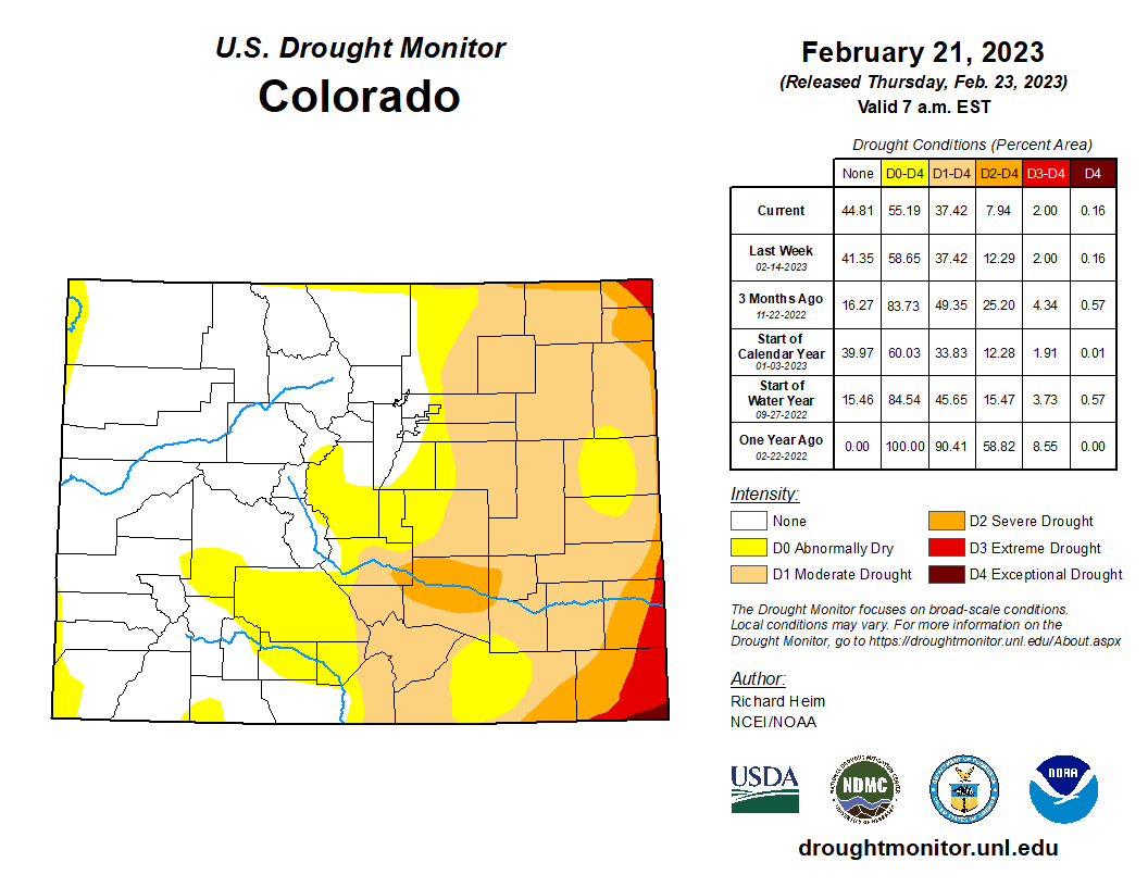
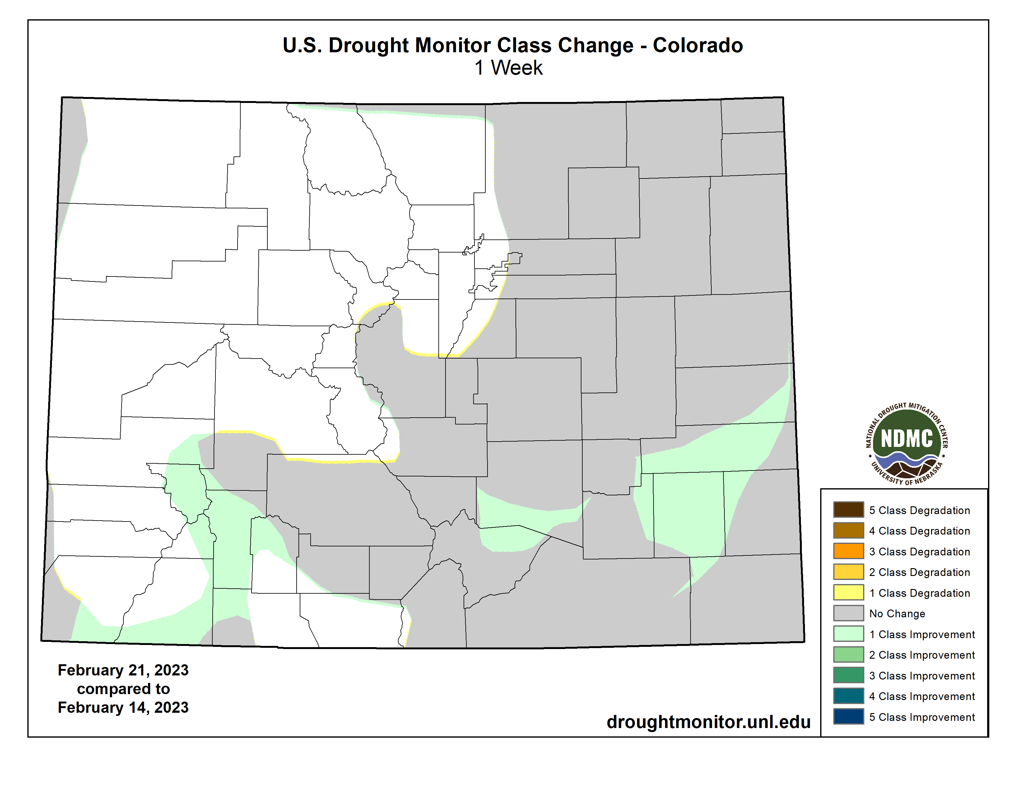
It was the 5th February in a row that was colder than normal: while temperatures in other months have been steadily rising, Feb has been going the other direction. And snowpack is good in all but the Arkansas basin. Read more in our February summary: https://t.co/iFxCFSJC9O#cowx
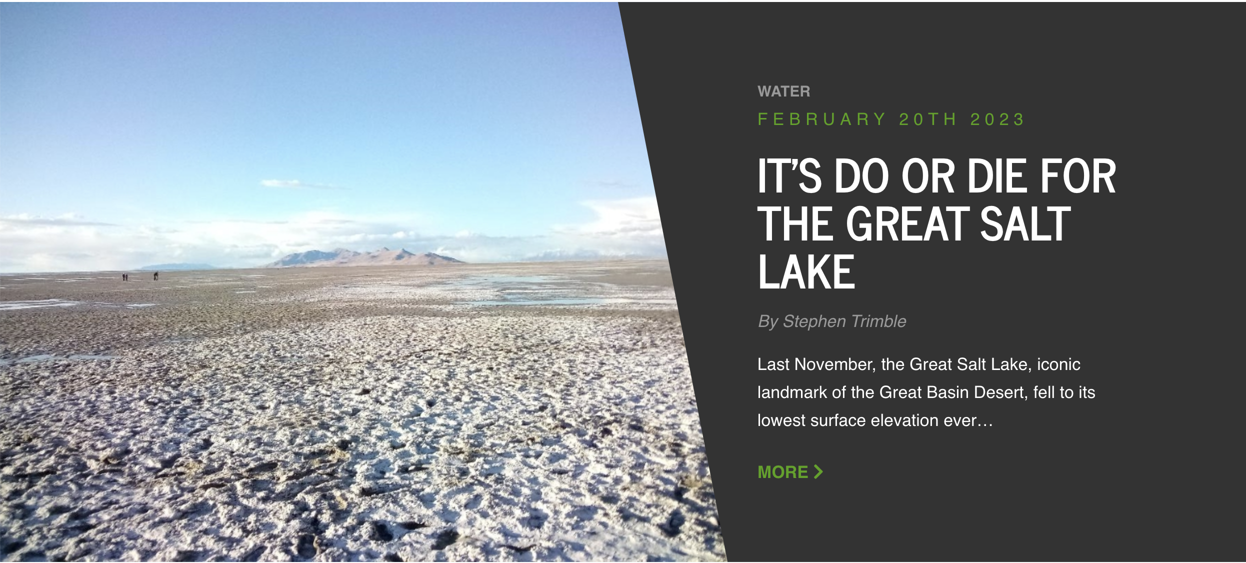
There’s a bit of a lull in the multiple conversations up and down the Colorado River Basin, with some positions staked out, while the Bureau of Reclamation initiates an ‘emergency environmental impact statement’ to ascertain, supposedly by late summer, what resolution it will either accept from the seven Basin states, or impose on the states, to reduce consumptive use throughout the Basin by two million acre-feet or more.
All of this is of course being covered in the mainstream media as a ‘water war,’ in their constant efforts to pump any cultural exchange up to a ‘let’s you and him fight’ situation. To call cultural negotiations a ‘war,’ even noisy negotitions among parties with interests at stake, both trivializes the terrible nature of ‘war’ and casts the exchange in an often exaggerated aspect of belligerent violence.
Arizona Navy photo via California State University
If you want to read about a Colorado River water war – fictional of course – pick up a copy of The Water Knife by Paolo Bacigalupe. Or if you like the comic opera version of a Colorado River water war, find an account of the 1934 incident when Arizona’s governor called out the Arizona National Guard to go occupy the site where California was beginning construction of Parker Dam and its Colorado River Aqueduct. Once you’ve got that warlust out of your system, come back to where the seven states and the feds are working on negotiated solutions, to avoid war.
Meanwhile, back in Central Arizona…. In my January 4 post on this site, I wrote about one of my favorite tributaries of the Colorado River, ‘the fabled Hassayampa’ in central Arizona, the waters of which, according to desert writer Mary Austin, will cause anyone who drinks to ‘no more see fact as naked fact, but all radiant with the color of romance.’
I opined much earlier here that there were probably more Colorado River tributaries than just that one which had that effect on those drinking from them, as evidenced by the extent to which the naked facts have obviously been left shivering in the dark as the development and management of the entire river has galloped along on the winged steeds of a romantic optimism. A romantic optimism that 6,000 years of both history and prehistory suggest should probably be taken carefully into the desert regions of the world, if at all – as, yes, Major John Wesley Powell tried to say 130 years ago, before he was booed off the stage at an Irrigation Congress pep rally around the turn of the century.
The earlier post was about the fact that the lower Hassayampa River Basin has been in the news as the site of a yet another proposed major new real estate development, Teravalis, in the desert west of Phoenix. If built out, Teravalis would add another 300,000 people to the 5 million already in the Phoenix metropolitan area. It would be competing with an already booming development just to its south in the same basin, the city of Buckeye (see its billboard above), which has gone from a farm village of 6,500 in 2000 to over 100,000 today. Here’s a map that gives you the general lay of the land in the Phoenix area:
The Hassayampa River bed is at the far left, north to south, with no surface flow; a small desert river keeps most of its water underground in the sand, gravel and cobble that protect it from the desert sun. The larger Salt River runs right to left through Phoenix, to its confluence lower center with the Gila River coming up from the south. The proposed Teravalis development lies just west (left) of the White Tank Mountains in the lower Hassayampa Basin. All the little green squares there are agricultural land, mostly irrigated now from groundwater.
But, as noted in the earlier post, Teravalis is temporarily on hold until it can prove that it controls enough water for a 100-year supply, most of which would be groundwater from the Hassayampa Aquifer. At that time, the Arizona Department of Water Resources was reportedly conducting a study of the aquifer, the results of which would also impact the future growth of Buckeye.
As it turns out, that study was already completed, last year! But then-Governor Doug Ducey decided not to release it, apparently under T.S. Eliot’s caution that ‘human kind cannot bear very much reality.’ The new governor Katie Hobbs has released the report, which concludes that, if the proposed development in the west valleys occurs, there will be a cumulative shortfall near the end of the hundred years of more than four million acre-feet of water.
‘I just think there was a lack of real honesty with the people of Arizona about the situation we’re in,’ Governor Hobbs said in an interview for a National Public Radio story. But at the same time, she said she doesn’t think it is necessary at this point to put the brakes on future development. ‘I think if we don’t really address these issues head on, look at the reality of the situation with water, look at how quickly we’re growing, then we will get to that point.’
This is, recall, part of the water supply in a river system whose managers have said at least two million acre-feet in consumptive use have to be cut in the very near future to save the water supply, which drives farmers and cities alike to pumping more groundwater from aquifers, with less renewable water to recharge the aquifers. When groundwater is pumped from an aquifer and not recharged fairly quickly, the ground begins to compress and close up the often tiny spaces from which the water has been drawn; the surface subsides, and the rechargable part of the aquifer disappears, generally forever. Parts of the Salt-Gila river system have already experienced subsidence of a dozen feet or so.
We should also note that a ‘100-year water supply’ depending mostly on groundwater is not necessarily a ‘renewable water supply.’ If the recharge rate is less than the withdrawal rate, it is still water-mining.
But the developers are relatively unfazed by the report. Buckeye Mayor Eric Orsborn, who also owns a construction company, told NPR that the report will help his city in its future water planning. Construction can continue now because the existing development has proved its 100-year supply. And for other developers: ‘I don’t think we want to shut off all of the growth trying to figure out the solution for all the growth. We can do this in an incremental approach.’
The plan to increase the water supplies is basically to go out into the region and look for water to import from other basins. The 100-year rule only applies in the metropolitan corridor; in ‘rural’ Arizona there are still no limits on groundwater pumping. At the extreme, there has been talk of building a big desalinization plant in Mexico and piping the water to Central Arizona – a fantastically expensive idea with current technology. But this is now, that will be then, and who knows what might be possible then? The beat goes on.
The developers, realtors, construction companies and community boosters that make up the growth economy of the Southwest say, of course, that the people are coming, so we have to keep on building for them; we can’t just shut them all out because we aren’t certain how much water we’ll have a hundred years down the road! That the people will keep on coming is undoubtedly true to some extent, but – do we have to keep luring them into the desert with promises of green oases? Looking at Buckeye’s billboard at the beginning of this post, should we maybe consider some ‘truth in advertising’ measures?
For example: how about making the entire growth industry, realtors to builders, do what tobacco purveyors have to do now. Make them put on billboards, brochures and advertisements like Buckeye’s, in letters large enough to read with the naked eye, warnings like these:
SITTING OUTSIDE ON THE LAWN IN XX% OF PHOENIX’S SUMMER DAYS WILL KILL YOU IN X HOURS FROM EXTREME HEAT
or
LAWNS LIKE THE ONE PICTURED ARE NOW ILLEGAL FOR RESIDENCES
or
THIS IS A DESERT WITH STRESSED ENERGY RESOURCES, AND YOU MIGHT DIE HERE IF AIR CONDITIONING FAILS
Just a thought. Next post, we’ll take a gingerly look at appropriation law, and muse on how, or if, it can still function in a situation where there’s nothing left to appropriate.
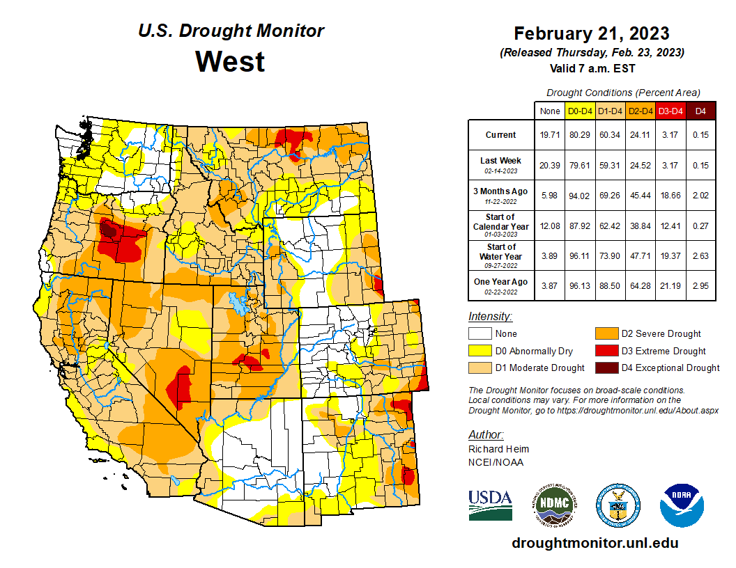
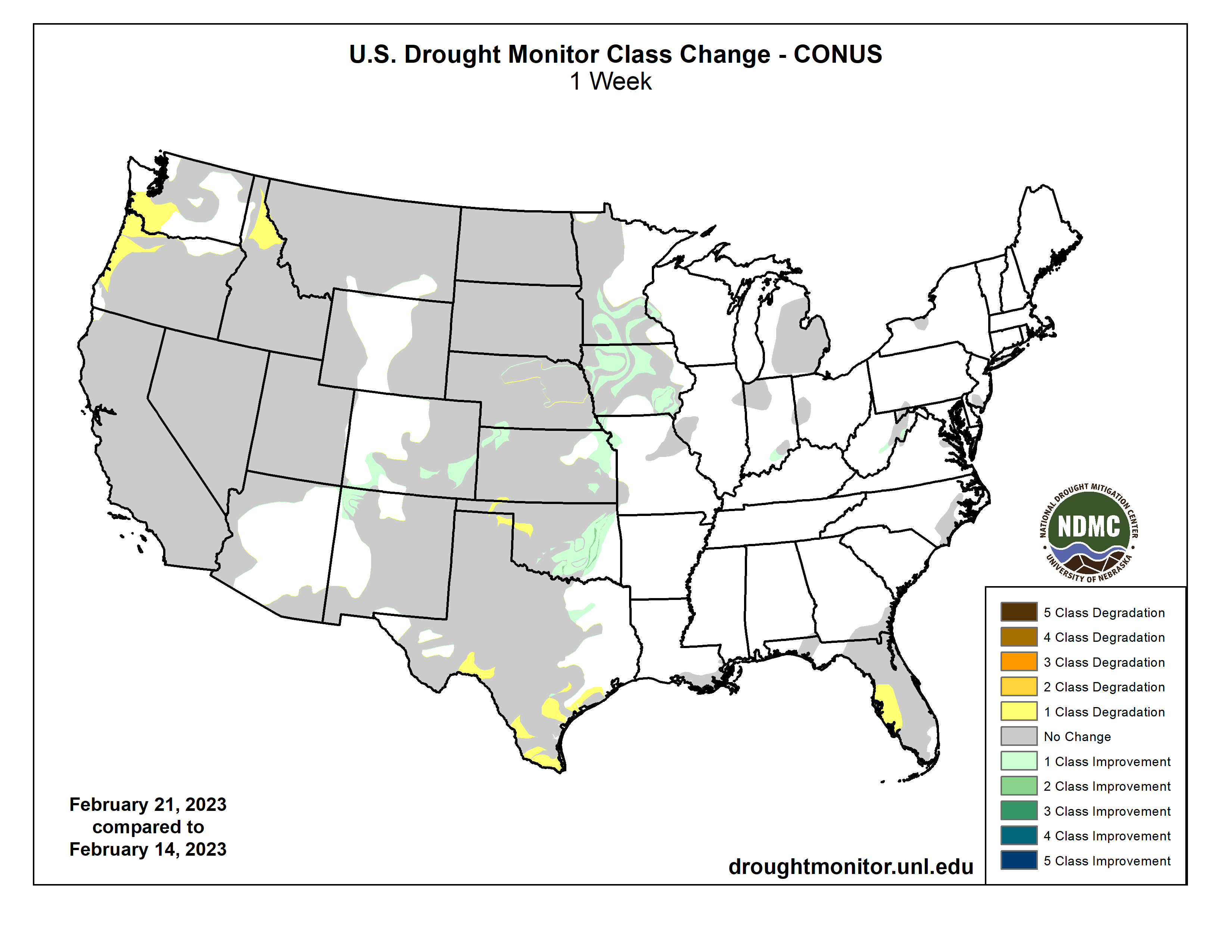
A series of severe weather events moved across the South and Southeast this week, bringing damaging winds, tornados and heavy rainfall. As these storms moved through the Midwest, many locations experienced record daily rainfall. This same storm brought snow to the upper Great Lakes and parts of the Northeast. Precipitation was scarce across other areas of the country, including parts of the West, the High Plains and Deep South. Drought and dryness expanded in parts of the Pacific Northwest, southern Texas and the Gulf and Atlantic coasts. Drought improvements were seen across the West from prior weeks’ precipitation events. In addition, parts of the southern Plains, Great Lakes and mid-Northeast regions also saw improvements…
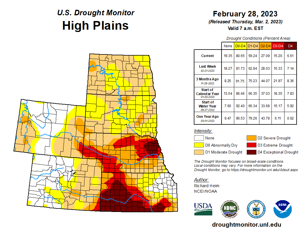
Much of the High Plains remains in long-term drought, with the central High Plains seeing some expansion of moderate drought (D1) from southeast Nebraska to northeastern Kansas based on continued lack of recent precipitation, low streamflows and soil moisture. In the Colorado Rockies, abnormal dryness (D0) was slightly expanded based on below-normal precipitation. In south-central Colorado, abnormal dryness (D0) was expanded because of continued lack of precipitation and low soil moisture. However, southeast Kansas received heavy rain from severe storms that extended from the South and Southeast into the Great Lakes regions. The northern High Plains also saw improvements in north-central/northeastern Nebraska and southeastern North Dakota in response to the season’s heavy snows. Soils are still frozen, so the full benefits of the season’s precipitation will not be realized until the soils thaw and the snow meltwater soaks into the ground. Wyoming also saw improvements to moderate drought (D1) where precipitation deficits have recovered…
Colorado Drought Monitor one week change map ending March 7, 2023.
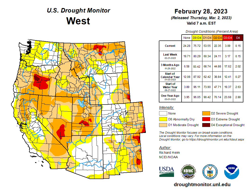
This week, additional rounds of rain and snow added to the ample precipitation received across the West since December 2022. Continued analysis of the effects of the season’s moisture resulted in continued improvements to long-term drought conditions in many parts in the West. California saw improvements to severe (D2) and moderate (D1) drought, as well as abnormal dryness (D0) along the central coast and in the San Joaquin Valley and southern California. National Weather Service offices in the area report extremely wet conditions. Water-year-to-date (WYTD) precipitation is 150% of normal or higher, and nearly every indicator shows improvement with all but the longest timescales (24-to-36-month precipitation) showing above-normal conditions. Similarly, the season’s precipitation chipped away at long-term drought areas in southern Nevada (D2 and D3), parts of Utah (D2 and D3) and western New Mexico (D1, D2 and D3). Precipitation deficits, soil moisture and streamflow show recovery. Groundwater levels and reservoir storage, which takes longer to recover, however, remain low. Precipitation in the Pacific Northwest helped improve severe drought (D1) in western Idaho and abnormal dryness (D0) in southwest Montana. Precipitation indicators in these areas are wet out to 12 months. In the rest of the Northwest, recent precipitation wasn’t enough to warrant improvement. Moderate drought (D1) expanded in north central and northeast Oregon where WYTD precipitation, streamflow and soil moisture is low. The Oregon state climatologist notes that “This water year has been surprisingly dry across the state despite the near-normal snowpack. Approximately 70% of the state only has 75% of normal WYTD precipitation, and about 25% is below 50% of average.” In Montana, severe drought (D2) expanded in response to low snow accumulations and its effect on streamflow and soil moisture…
Storms brought high winds, tornadoes and heavy rain to parts of the South. A band of heavy rain, over 300 percent of normal (over the last 7 days), fell over drought areas in north-central and central Texas. But, because precipitation is low in Texas this time of year, totals ranged from about 0.5 to 1 inch and provided minimal relief to areas in moderate (D1), severe (D2) and extreme (D3) drought. Longer term deficits remain, and streamflow values quickly returned to below normal over much of the region. Otherwise, most of Texas received little to no rainfall, and many locations experienced an expansion of drought conditions. In the Panhandle, D3 expanded slightly. Precipitation there is less than 25 percent of normal over the last 30 days, and satellite derived soil moisture is very low (5th percentile or less). In South and West Texas, all drought levels expanded as the dry pattern continued. Precipitation in these areas has been less than 10 percent of normal over the last 30 days. The dry weather, combined with temperatures of 3 to 6 degrees above normal, has dried out soils and increased fire danger (as indicated by the Keetch Byram Drought Index). CoCoRaHS observers in South Texas note the lack of measurable rain, cracks in the soil and plants with discoloration and delayed growth. In Oklahoma, 5 to 10 inches of rain fell last week (300% of normal) over the state’s eastern drought boundary. Repeated bouts of moisture have led to short-term improvements overwhelming longer-term deficits, resulting in 1-category improvements. The state climatologist for Oklahoma noted that over half of the reservoirs in the southeast part of the state are now over their conservation pool or close to normal. Meanwhile, short- and long-term drought still have a grip on the northwest part of the state. Dry conditions combined with above normal temperatures and high winds have resulted in several fires…
Looking Ahead
The National Weather Service Weather Prediction Center forecast for the remainder of the week (valid March 8 – March 11) calls for an atmospheric river to bring heavy rainfall, flooding and high-elevation snow to the West Coast. A winter storm tracking across the central High Plains and upper Midwest is also expected to bring snow to these regions, with the heaviest amounts in southern Minnesota, northern Iowa and southern Wisconsin. As this storm moves eastward, mixed precipitation is likely in a band stretching from eastern Nebraska to southern New York. Heavy rain and thunderstorms are expected across the southern Plains, the South, lower Midwest and the Southeast.
US Drought Monitor one week change map ending March 7, 2023.
Just for grins here’s a gallery of US Drought Monitor maps for early March from the last few years.
U.S. Sen. Michael Bennet and U.S. Rep. Joe Neguse of Colorado on Monday wrote a letter to U.S. Agriculture Secretary Tom Vilsack urging him to formally suspend federal authorization of a Utah rail project that will send up to five, two-mile-long oil trains a day along the Colorado River, under the Continental Divide at Winter Park, and through downtown Denver.
Citing “ongoing concerns about the risks to Colorado’s communities, water, land, air, and climate from the Uinta Basin Railway Project,” Bennet and Neguse noted the U.S. Forest Service, part of the Department of Agriculture, has yet to issue a special use authorization for construction of the 88-mile railway that would run through the Ashley National Forest in Utah and connect the oil fields in the northeastern part of that state to the nation’s main rail network.
“We urge you to formally suspend any decision on that authorization until a supplemental review is conducted to fully evaluate the effects of this project on Colorado’s local communities and environment,” the Bennet-Neguse letter states. “This review is especially critical in light of the recent train derailment and environmental disaster in East Palestine, Ohio, which has laid bare the threat of moving hazardous materials by rail.”
A Norfolk Southern freight train derailed on Feb. 3 in East Palestine, leading to the toxic release of vinyl chloride.
The Forest Service last July approved the Utah project but still must issue a special use permit, and the U.S. Surface Transportation Board, which oversees the nation’s railroads, gave the Utah project the nod more than a year ago despite a dissenting vote from STB Chairman Martin Oberman. It’s estimated the new railway will enable up to 4.6 billion gallons of waxy crude oil a year to travel Colorado’s Central Corridor rail line on its way to Gulf Coast refineries.
“These trains would run for over 100 miles directly alongside the headwaters of the Colorado River — a vital water supply for nearly 40 million Americans, 30 tribal nations, millions of acres of agricultural land, and a main driver of our state’s recreation and tourism economies,” the letter states. “The river is already in crisis, unable to provide the water needed to meet demand.”
Bennet and Neguse, both Democrats, write in their letter that the Forest Service’s own “flawed” projections predict at least one oil spill derailment every four years in Colorado, with heated oil tanker cars likely to spark wildfires in remote canyons, leading to further mudslides like the ones that have plagued Glenwood Canyon — frequently shutting down Interstate 70.
Neguse’s 2nd Congressional District, which stretches from Eagle County in the west to the northern Front Range in the east, has seen some of the state’s largest wildfires, including the Grizzly Creek fire in Glenwood Canyon in 2020.
“Folks in my district — in communities along the proposed railway — are deeply concerned about this project, and I share their concerns,” Neguse told Colorado Newsline. “The recent toxic train derailment in East Palestine, Ohio, serves as yet another reminder of the potential damage these freight trains can cause. That is precisely why Sen. Bennet and I are calling on Secretary Vilsack to suspend any decision authorizing the construction of the Uinta Basin Railway until a full evaluation can be completed. For the wellbeing of Coloradans and everyone involved, we must adequately account for all possible consequences before moving forward in any manner.”
Bennet in an email to Colorado Newsline criticized environmental reviews to this point.
“The environmental reviews conducted thus far have been deeply flawed. Especially in light of what happened in Ohio, the federal government should be focused on a thorough evaluation of the risks of derailment,” Bennet told Colorado Newsline. “A derailment of this train could ignite a wildfire or severely contaminate the Colorado River, which is already in crisis. The absolute last thing the federal government should do is finance this project with taxpayer money.”
A public good?
As first reported by the Colorado Sun, the Seven County Infrastructure Coalition in eastern Utah last month approved the Uinta Basin Railway seeking up to $2 billion in tax-exempt private activity bonds allocated by the U.S. Department of Transportation in order to fund the now nearly $3 billion rail spur being built exclusively for oil shipments. Those bonds in the past have funded public benefits such as Front Range highway improvements and passenger rail in Florida.
Allocation of PABs to fund an oil rail spur, critics say, would be unprecedented.
“I have to presume there’s something in there that (the tax-exempt funding) has to be for a public good,” said Eagle County Commissioner Matt Scherr, whose county is suing to stop the Uinta Basin Railway on environmental grounds. “And, for right now, under the Biden administration anyway, pulling more oil out of the ground and shipping it 2,000 miles for processing does not represent a public good.”
Drone footage shows the freight train derailment in East Palestine, Ohio, U.S., February 6, 2023 in this screengrab obtained from a handout video released by the NTSB. NTSBGov/Handout via REUTERS
Representatives of Utah’s Seven County Infrastructure Coalition and the Uinta Basin Railway did not return emails and social media messages seeking comment on the Bennet-Neguse letter and Bennet’s separate opposition to using tax-exempt PABs to fund the oil rail project.
“This is a pretty momentous occasion to approve a resolution for a project this big,” coalition chairman Casey Hopes said after the Feb. 9 vote at the Utah Capitol. “And I appreciate all the work that’s gone in on the back end from so many in the room … We’re looking forward to the day when we get to ride the first train out of the Uinta Basin.”
U.S. Sen. Mitt Romney of Utah also is a fan of the project, stating Feb. 16 on Twitter: “The Uinta Basin Railway will be key to the region’s economic future. Met with Duchesne County Commissioner Greg Todd and County Recorder & (Utah Association of Counties) President Shelly Brennan for an update on the railway project. Grateful for their efforts to foster further economic development.” Romney is joined by fellow Utah Republican Sen. Mike Lee in backing the project, which would send up to 350,000 barrels of oil a day through Colorado.
Vilsack last summer declined to discuss the Uinta Basin Railway: “You know, this is currently in litigation. Folks are raising questions about the Surface Transportation Board’s decision, and it’s probably inappropriate for me to comment too much about this.”
Hazardous materials would quadruple
The active Central Corridor line through Grand Junction and Glenwood Canyon cuts through the northwestern corner of Eagle County and follows the Colorado River into Grand County, where it then travels through the Continental Divide at the state-owned Moffat Tunnel at Winter Park.
“While the State Legislature does not have any legal jurisdiction over this decision, as an Eagle County resident myself and a legislator who represents thousands of constituents that could be impacted by these impending decisions across multiple counties in my district, I am terribly concerned,” state Sen. Dylan Roberts of Avon said in an email. “In a time where our water is more precious than ever, it seems completely contrary to common sense to risk contamination of the headwaters of the Colorado River in order to transport more fossil fuels in a hazardous and expensive way.”
Roberts said he’s working with Western Slope colleagues on a letter to federal representatives, the U.S. Department of Transportation and others to express those concerns in the coming week. Scherr confirmed Eagle County will be a party to that letter.
Part of Eagle County’s legal challenge is the fear that the dramatic increase in trains carrying hazardous materials through the Denver area will put pressure on Union Pacific to reopen its long-dormant (but not abandoned) Tennessee Pass Line, which connects to the Central Corridor at Dotsero and travels along the Eagle and Arkansas rivers to Pueblo.
“I personally strongly call on those in the power to make these decisions to rethink (the Uinta Basin) proposal and to take the use of Tennessee Pass off the table in light of the East Palestine disaster and the acute water crisis Colorado and the West currently faces,” Roberts added.
The Denver Office of Transportation and Infrastructure recently produced a report predicting that the number of rail cars with hazardous materials traveling through Denver would quadruple over the next three to four years, largely due to the Uinta Basin Railway.
“I am deeply concerned about rail safety in Colorado, and in Denver in particular, since it is a rail hub in a heavily populated area,” Denver mayoral candidate and state Sen. Chris Hansen, a Democrat, told Colorado Newsline in a text. Hansen has been a champion of renewable energy in the Legislature. “The tragic accidents in Ohio reinforce the urgency to improve safety rules, and I will be looking at state and local options and advocate for improved federal rules.”
Ted Zukoski, an attorney with the Center for Biological Diversity — an environmental group also suing to stop the Uinta Basin Railway — questioned the federal government helping to fund an oil freight project by covering 70% of the project with tax-exempt bonds.
“If you look at the list of projects that have been funded that have gotten the DOT’s approval to issue tax-exempt bonds, they are projects that benefit the general public — mass transit projects, bridge repair projects,” Zukoski said. “Anybody can use those projects and they’re a benefit to the general public. But this is a rail line that is projected to carry one product out of the basin, which is oil. So this would be a huge taxpayer subsidy to the oil industry at a time when we should be weaning ourselves off oil to combat the climate crisis.”
Zukoski points to one of President Joe Biden’s first acts in office in January 2021 when he signed an executive action on climate change: “This president announced a policy on Day One in his office of combating the climate crisis. And it is incompatible with combating the climate crisis to be shoveling money to a single purpose oil railroad.”
The WEco Water Fluency Program is a professional development course designed for anyone interested in gaining an in-depth understanding of Colorado water management and protection. This includes non-water professionals in leadership roles intersecting with water, as well as water professionals who are newer to the field or the state of Colorado or who want to gain a broader view of the issues beyond their unique niche. Past participants have included elected officials, city/county staff, community and business leaders, special districts staff, board members for water organizations, educators, and more.
Water is critical for every aspect of community vibrancy — from industry and commerce to agriculture, tourism, health and environment. But it isn’t always clear how water policy and management decisions trickle down to other sectors. Developing tools for navigating water management and policy issues, Water Fluency graduates take the language of water into their fields to lead with new confidence.
Rachel Carson in 1940. By U.S. Fish and Wildlife Service – This image originates from the National Digital Library of the United States Fish and Wildlife Serviceat this pageThis tag does not indicate the copyright status of the attached work. A normal copyright tag is still required. See Commons:Licensing.See Category:Images from the United States Fish and Wildlife Service.http://training.fws.gov/history/carson/carson.html, Public Domain, https://commons.wikimedia.org/w/index.php?curid=277288
Click the link to read the article on the Audubon website (from March 31, 2016, Emily Silber). Here’s an excerpt:
When we hear the word “naturalist,” we often think of Charles Darwin and his theories, John Muir, the “Father of National Parks,” and of course, John James Audubon. But let’s not forget the women who rallied to preserve the natural realm. From creating the first avian field guide, to ending the feather trade, to dying in pursuit of birds, these seven femmes prove that the history of incredible women transcends any single month.
Ohio native Genevieve Estelle Jones was a self-taught scientific illustrator christened the “other Audubon.” After seeing some of Audubon’s paintings at an exhibition, Jones decided to draw the nests and eggs of the 130 bird species nesting in Ohio at the time. But before she could finish, she died from typhoid fever at age 32. Her family spent the next seven years completing the hand-colored plates, of which 90 copies were made. Only 26 still exist.
This two-woman dream team was responsible for taking down the 19th-century plume trade and establishing the National Audubon Society. Appalled by the number of birds being killed in the name of fashion, Hemenway, an impassioned amateur naturalist, and her cousin Hall, persuaded their socialite friends to boycott the trade and protect the wildlife behind it. Ultimately, they recruited 900 women to join the fight, and gave rise to an establishment that, a century later, has grown to 1 million members and supporters strong.
Florence Merriam Bailey, maker of the first known bird guide, in New Mexico, 1901. Photo: Vernon Bailey Collection/American Heritage Center/University of Wyoming
Florence Merriam Bailey
1863-1948
American nature writer and ornithologist Florence Merriam Bailey was a jane of all trades. Not only did she work with the National Audubon Society during its early years, she is also credited for writing the first known bird guide, Birds Through an Opera Glass, published in 1889. A true pioneer in the field, Merriam protested the mistreatment, killing, and trade of feathered animals. Her legacy still remains in the form of a subspecies of the California Mountain Chickadee, Parus gambeli baileyae, that was named in her honor.
Rachel Carson
1907-1964
Rachel Carson is most famous for her book Silent Spring, in which she bared the sins of the pesticide industry. In her later writings, the author and activist continued to examine the relationship between people and nature, questioning whether human beings are truly the dominant authority. Needless to say, she was an outspoken advocate for the environment and one of the greatest social revolutionaries of her time.
Frances Hamerstrom
Position title:1907-1998. Photo credit: University of Wisconsin — Madison
Frances Hamerstrom
1907-1998
This female ornithologist dedicated the majority of her life to just one kind of bird: The Greater Prairie-chicken. Frances Hamerstrom headed a research team that ultimately saved the eccentric species from extinction in Wisconsin. She helped identify the ideal habitat for prairie-chickens, and was also one of the first to put colored leg bands on wild birds—a technique that has helped reveal important information on bird behavior through the decades.
Phoebe Snetsinger. Photo credit: Ornithology: The Science of Birds
Phoebe Snetsinger
1931-1999
When faced with the grim diagnosis of melanoma, 50-year-old Phoebe Snetsinger turned her life upside down: She went from being a housewife to racing around the globe as a competitive birder. Despite being beaten and raped in Papua New Guinea, Snetsinger never gave up on her passion. In 1995, she broke a world record by being the first person to spot more than 8,000 species of birds. A short time later she died in a bus crash while birding in Madagascar. But she will always be celebrated for living life with absolute fearlessness.
These women are just a few of the heros who forged the path for the modern-day bird-conservation movement. Today’s ornithologists, birders, and activists certainly match their passion and dedication. In fact, in 2011, of the 47 million birdwatchers in the United States, more than half were women. Between women spearheading sustainable projects around the world, Audubon’s standout conservationists, and badass chicks who love to bird . . . our avians are in very good hands.
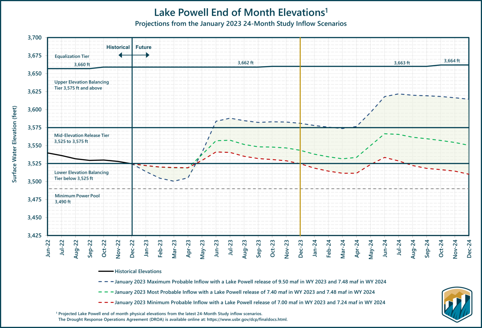
Starting Tuesday [March 7, 2023], the US Bureau of Reclamation will suspend extra water releases from Utah’s Flaming Gorge reservoir – emergency measures that had served to help stabilize the plummeting water levels downstream at Lake Powell, the nation’s second largest reservoir…
The decision to suspend the monthly water releases, which were slated to continue through April, comes in the wake of a winter that has brought well above-average snowfall and precipitation in much of the West, which state and federalofficials are hoping will buy them some more time as they scramble to come to an agreement on significant water usage cuts from the Colorado River Basin. The suspension of Flaming Gorge releases was initially requested by four states in the upper Colorado River Basin – Utah, Colorado, Wyoming and New Mexico. The system is like a water loan program from Flaming Gorge to Lake Powell “in times of crisis,” said Chuck Cullom, executive director of the Upper Colorado River Commission.
“With snowpack in the upper Colorado River system running upwards of 130% of the 30-year median, we have a unique opportunity – perhaps once-a-decade opportunity – to repay the loan,” Cullom told CNN. “Aridity is our present and future and we’re trying to adapt to this unique set of circumstances.”
Click the link to read the release on the USGS website (Heidi Koontz):
BOZEMAN, Mont. — The western bumble bee was once common in western North America, but increasing temperatures, drought, and pesticide use have contributed to a 57% decline in the occurrence of this species in its historical range, according to a new U.S. Geological Survey-led study.
Using data from 1998-2020, scientists determined that increasing summer temperatures and drought partly drove declines of the native western bumble bee in recent decades, with rising temperatures being particularly important. The decline in pollinators is a cause for concern because most flowering plants depend on pollinators such as the western bumble bee to promote reproduction. Pollinators are also essential to our agriculture industry and economy and provide fruits, seeds and nuts that both humans and wildlife rely on. To further complicate matters for the western bumble bee, climate change continues to make rising temperatures and drought more common in the western states.
“There has been an ongoing global decline in pollinators, including in North America,” said Will Janousek, USGS scientist and co-lead author of the study. “The decline in the once common western bumble bee shows that common, widespread species are not excluded from this trend and our study showed that climate change is an important reason for the decline of this native bee species.”
Death by a thousand cuts: Global threats to insect diversity. Stressors from 10 o’clock to 3 o’clock anchor to climate change. Featured insects: Regal fritillary (Speyeria idalia) (Center), rusty patched bumble bee (Bombus affinis) (Center Right), and Puritan tiger beetle (Cicindela puritana) (Bottom). Each is an imperiled insect that represents a larger lineage that includes many International Union for Conservation of Nature “red list” species (i.e., globally extinct, endangered, and threatened species). Illustration: Virginia R. Wagner (artist).
The research team found another reason for the reduced distribution of the once common western bumble bee in a pesticide use dataset spanning 2008-2014: a group of insecticides called neonicotinoids, which are commonly used in agriculture. In areas where neonicotinoids were applied, the western bumble bee was less likely to occur and as the rate of neonicotinoid application increased, the bumble bee’s presence declined further.
The scientists also projected the future status of the western bumble bee in 16 regions of the western United States in the 2050s under different future scenarios, considering increasing levels of future climate stressors, changing forest and shrub cover, and other factors.
“Even considering the most optimistic scenario, western bumble bee populations are expected to continue to decline in the near future in nearly half of the regions across the bumble bee’s range,” said Tabitha Graves, USGS scientist and co-lead author on the study. “Considering the more severe, but probably more likely scenarios, western bumble bee populations are expected to decline an additional 51% to 97% from 2020 levels depending on the region.”
This study was a collaborative effort between the USGS, U.S. Fish and Wildlife Service, U.S. Department of Agriculture-Agriculture Research Service, Dickinson College, Canadian Wildlife Service, Montana State University, Xerces Society for Invertebrate Conservation, University of Colorado Boulder, The Ohio State University, and the University of Wyoming. It is published in the journal Proceedings of the National Academy of Sciences. For more information on bumble bee research in the West, please visit the USGS Northern Rocky Mountain Science Center website.
Sources/Usage: Public Domain.
USGS scientist Tabitha Graves collects western bumble bee samples in eastern Montana.
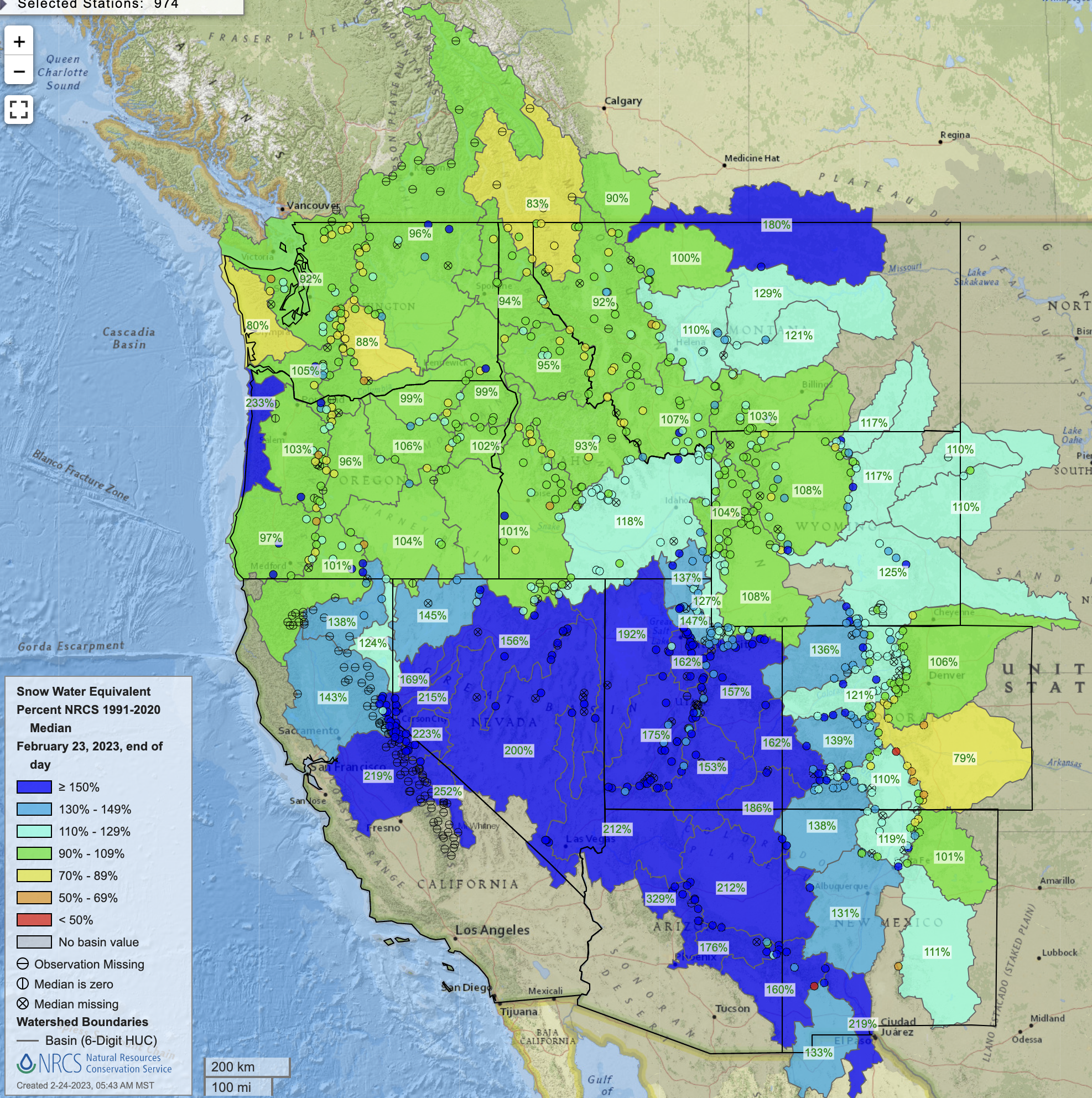
This SNOTEL site at about 8,774 feet at the top of McClure Pass was measuring 154% of median snowpack on March 1, 2023. Lower elevation SNOTEL sites across the West Slope are showing a higher percentage of median snowpack than those at a higher elevation (above 10,000 feet). CREDIT: HEATHER SACKETT/ASPEN JOURNALISM
Snowpack on the Western Slope is tracking above average for this time of year, which has some forecasters feeling optimistic about spring runoff. But there is also an interesting phenomenon that they don’t yet know what to make of.
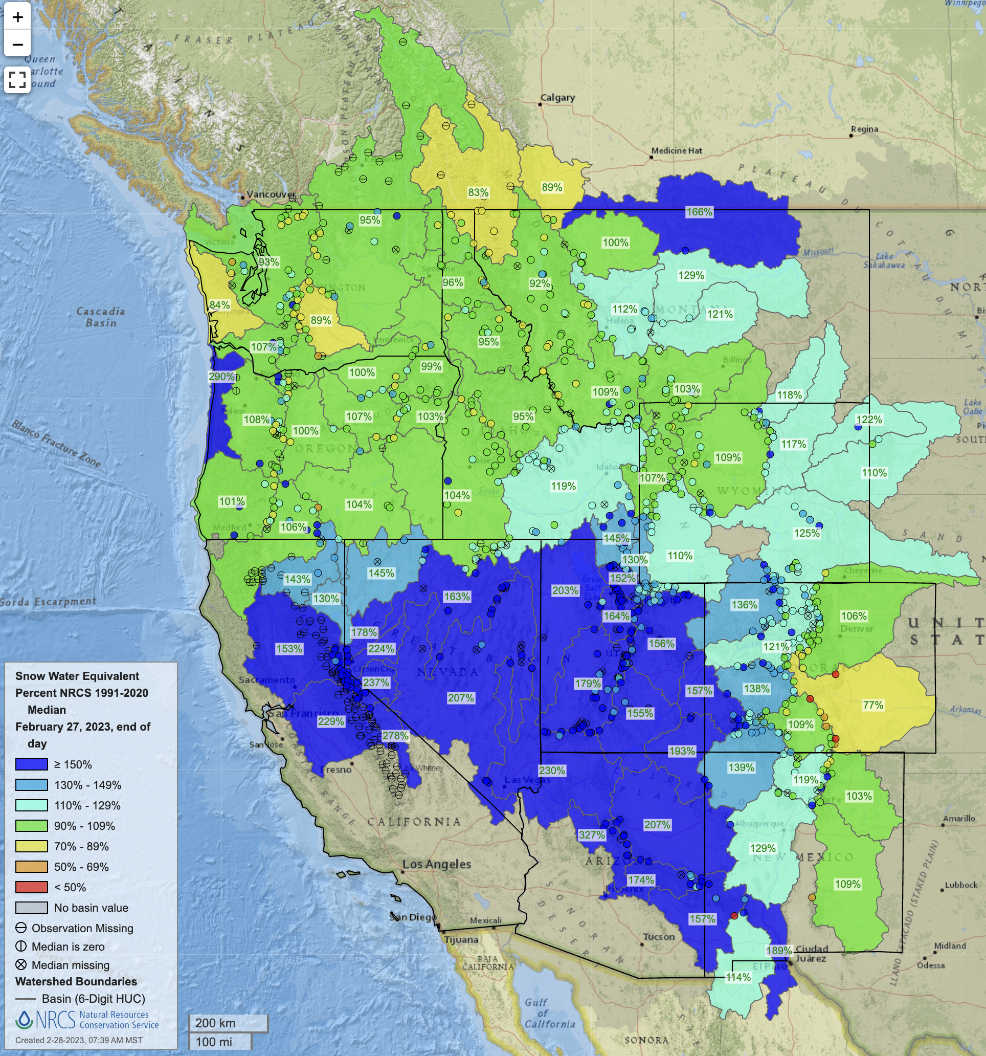
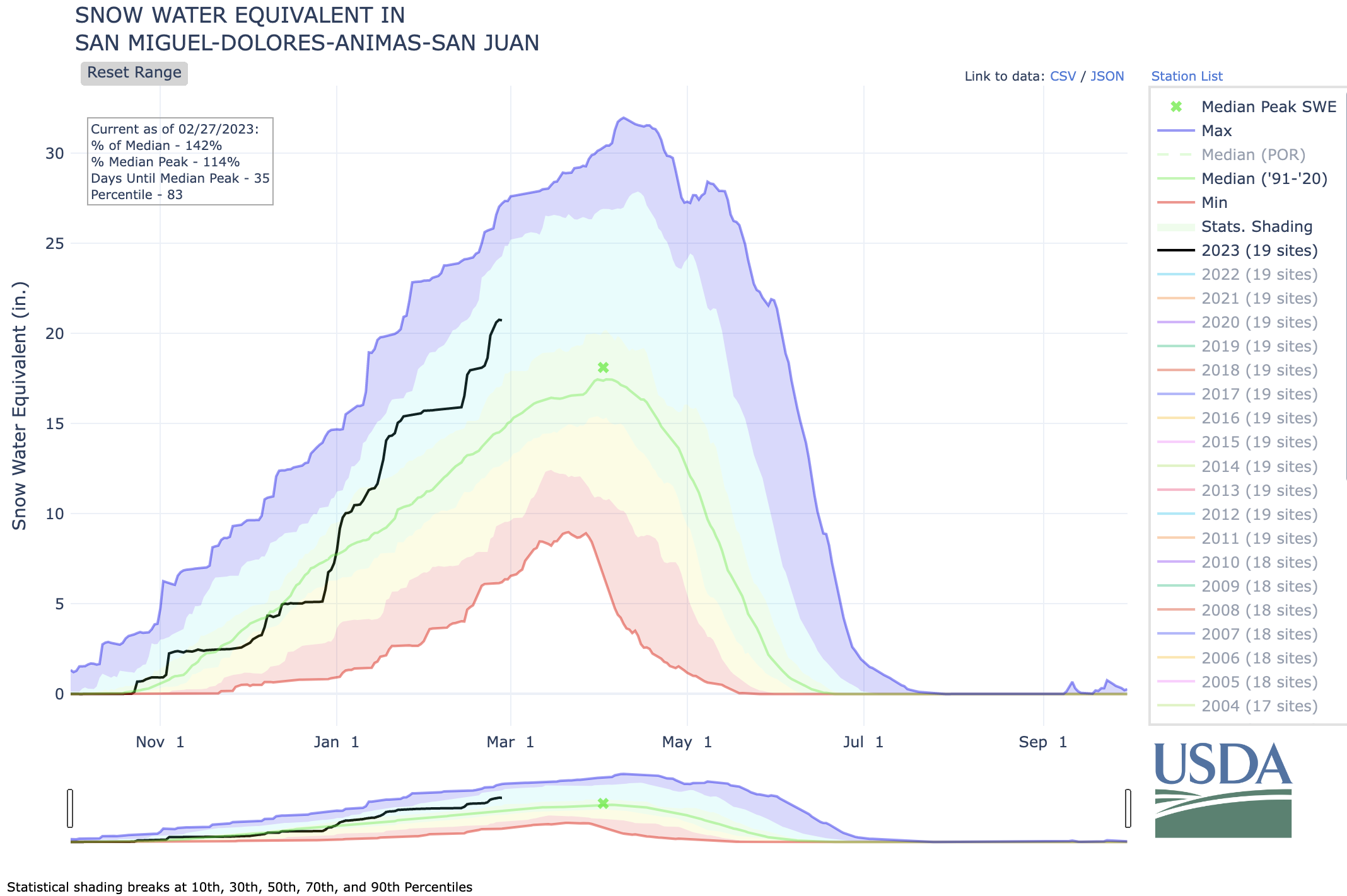
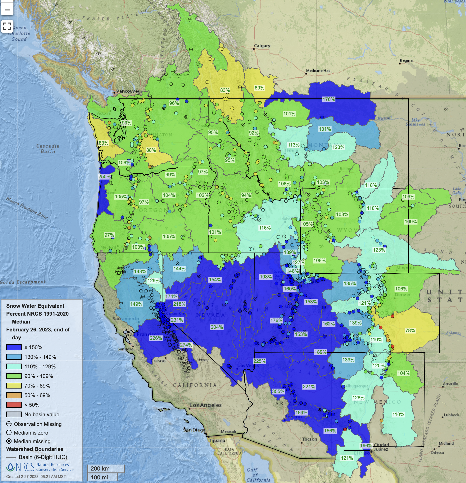
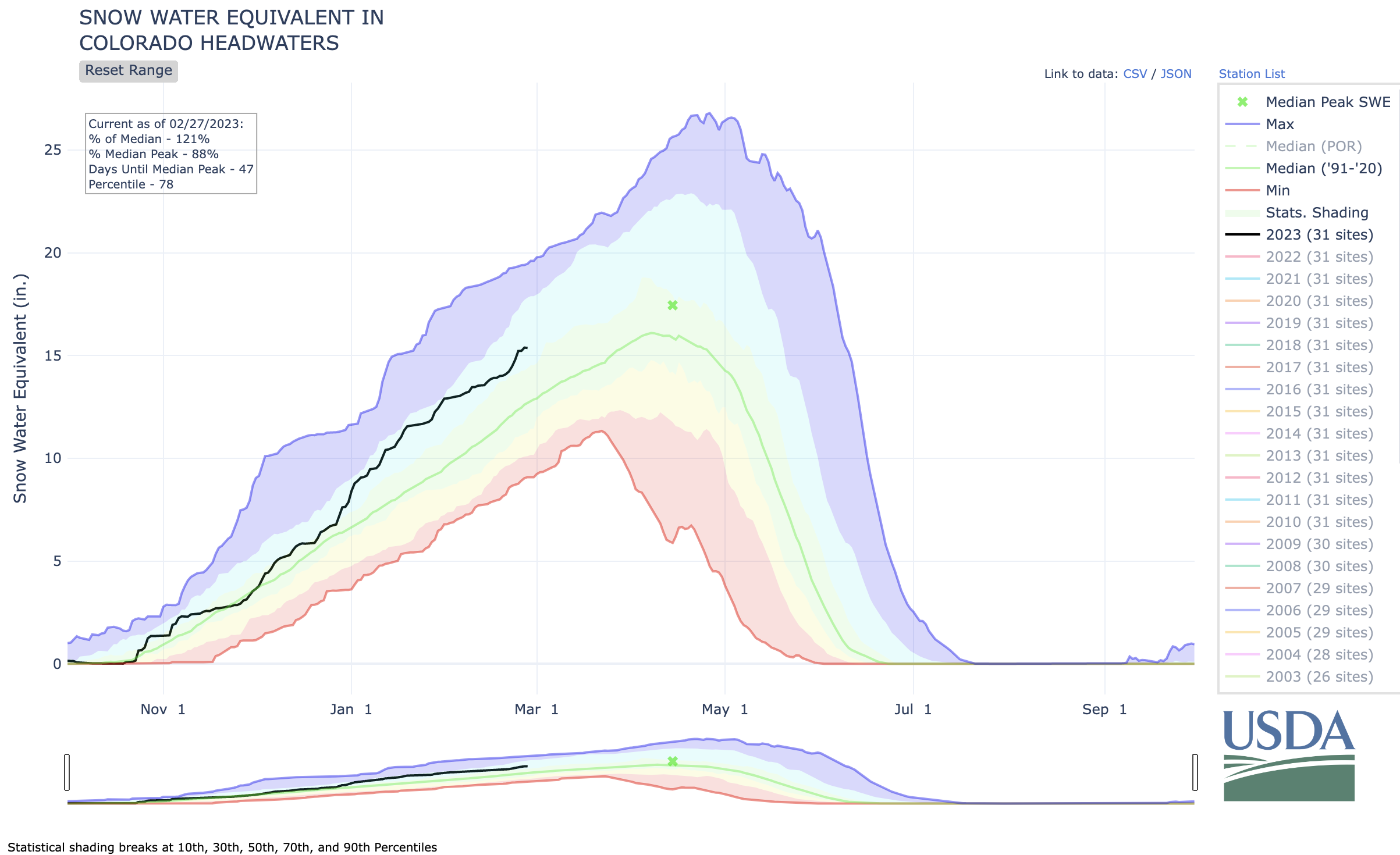
The snow-water equivalent — a measure of how much water is contained in the snowpack — for the headwaters of the Colorado River stands at 116% of average. That number is measured by snow telemetry (SNOTEL) sites, which are remote sensing stations throughout the West’s mountainous watersheds that collect weather and snowpack data.
Most of the lower-elevation SNOTEL sites (10,000 feet and below) have a higher percentage of median snowpack than high-elevation sites (above 10,000 feet). For example, in the Colorado basin, low-elevation SNOTELs are at a combined 121% of average while high-elevation ones are at 112% of average.
This trend holds true across the Western Slope with the Gunnison, Southwest and Yampa/White/Green river basins at 155%, 152% and 142% of average, respectively, for low-elevation sites and 119%, 136% and 122% for high-elevation sites. In the Roaring Fork basin, snowpack is at 110% for the four high-elevation sites and 134% for the four low-elevation sites.
“I can pretty confidently say sites below 10,000 feet have that trend pretty clearly exhibited,” said Karl Wetlaufer, a hydrologist and assistant supervisor at the National Resources Conservation Service’s Colorado Snow Survey. “It’s certainly an interesting observation.”
Why this counterintuitive trend is occurring is unclear. This winter’s storm patterns may be favoring lower elevations. Or colder-than-average temperatures and overcast days in February may have allowed the snowpack at lower elevations to continue accumulating. The February temperatures for western Colorado were on average about 2 degrees below normal, according to the NRCS.
“We’ve been cloudier, colder, and that has probably helped prevent some melting at lower elevations that might typically take place,” said assistant state climatologist Becky Bolinger. “We will definitely want to look into why the lower elevations are performing so much better than the higher elevations.”
Snowpack above average
Snowpack overall on the Western Slope is above average, with some basins — the southwest, which includes the San Miguel, Dolores, Animas and San Juan rivers and the northwest, which includes the Yampa, White and Little Snake rivers — already surpassing the average seasonal peak. Snowpack typically peaks the first week or two in April.
What more snow at lower elevations means for the timing of this spring’s runoff is also unclear, but forecasters say runoff volume should be above average.
“Big picture, this year is looking very, very favorable for all of western Colorado, and it’s a really big turnaround from the last couple of years,” Wetlaufer said. “It’s kind of tough to parse out the impact of this lower-elevation snow being at a higher percent of median than higher-elevation snow, but, in a general sense, I would certainly say it’s quite encouraging for ample snowmelt runoff this season.”
This is partly because lower elevations encompass more surface area than higher ones; there is simply more land below 10,000 feet than above, and if it is covered in an above-average snowpack, that is a good thing for streams and soils.
“Having that lower-elevation snowpack is going to help keep soil-moisture levels high, which can help the efficiency of the higher-elevation snow when it does melt at a later date,” Wetlaufer said. “Substantial low-elevation snow is going to wet up the soil conditions and allow most of that snowmelt to actually transition to the stream channel.”
In recent dry years, thirsty soils have sucked up runoff before it made it to streams. For example, 2021 was historically bad, with an upper basin snowpack that peaked about 90% of average but translated to only 36% of average runoff into Lake Powell, according to the U.S. Bureau of Reclamation. It was the second-worst runoff on record after 2002.
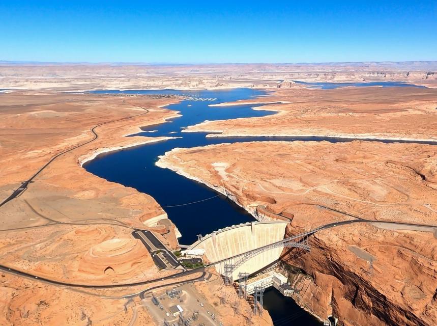
Although water managers are feeling confident that this year will be better and give a boost to depleted reservoirs in Colorado, they caution that one good year is not enough to pull the entire system out of a crisis. Lake Powell, which is the storage bucket for the upper basin states of Colorado, Utah, New Mexico and Wyoming, is at about elevation 3,521 feet, or about 23% full, the lowest since filling.
“Is this going to solve the Lake Powell and Lake Mead crisis? Not even close,” Bolinger said. “But the forecasted inflows into Powell are above average right now. There’s a silver lining there.”
Aspen Journalism covers water and rivers in collaboration with The Aspen Times.
In Colorado, farmers must enroll in a four-state program by March 1, if they want to get paid for fallowing their fields perhaps the best option to plump up the Colorado River’s giant reservoirs, Mead and Powell.
Andy Mueller, the general manager of the Colorado River District, speaking at the district’s annual seminar on the Colorado RIver, on Sept. 14, 2018 in Grand Junction. Muller expressed concerns about how the state of Colorado might deal with falling water levels in Lake Powell and Lake Mead. Photo credit: Brent Gardner-Smith/Aspen Journalism
Not everyone is a fan, including Andy Mueller, director of the Colorado River District. He doesn’t like programs that pay farmers to stop farming. Mueller also didn’t ask for the Inflation Reduction Act’s $125 million to pay the farmers he represents. Mueller’s organization exists to keep Western Colorado’s rural water away from growing cities across the Rockies.
State Sen. Dylan Roberts, D-Avon, who chairs the Committee for Agriculture and Natural Resources, has a more nuanced view. He says he understands that rural communities fear a “buy and dry” scenario. Where annual leases become routine, and once-verdant fields and farms wither. He insists that any water leasing must be temporary, voluntary and well compensated.
A water-leasing program called demand management was created for Colorado irrigators under former Colorado Gov. John Hickenlooper — it was tested, but never used. It would have allowed farmers to lease and store their water in a Lake Powell account under state control. Under Gov. Jared Polis’ administration, however, demand management was quietly shelved.
Now, this new, multi-state program for leasing agricultural water, called a “system conservation pilot program,” isn’t getting much traction. The program was announced two and a half months ago by Utah, Colorado, New Mexico, and Wyoming.
Its major drawback, says Tom Kay, an organic farmer in western Colorado, is that the Upper Colorado River Commission is offering a “stupid price of $150 an acre-foot.”
“Farmers like to farm; you have to pay them more than they make farming to interest them,” Kay adds. He gets around $650 per acre-foot of water growing mostly organic corn and dry beans on his 350-acre farm near the town of Hotchkiss.
Kay says he recently toured California’s Imperial Valley, where farmers are getting $679 an acre-foot. They sell their 200,000 acre-feet of Colorado River to the San Diego County Water Authority and consider the price reasonable.
Water prices are also rising. In California last summer, when the Bureau of Reclamation was looking hard for water, large irrigation districts in the Lower Basin were asking $1,500 per acre-foot to lease their water to cities, reported Janet Wilson of California’s Desert Sun.
If farmers got more money for their water under the new pilot program, says State Sen. Roberts, Colorado “could get more participation (and) show the federal government we are doing our part.” He also says that many state legislators think California and Arizona should bear the brunt of water cuts.
Getting farmers to fallow their land could build resilience in the Colorado River Basin, says Aaron Derwingson of The Nature Conservancy. A few years ago, he worked with grower Kay and Cary Denison, formerly of Trout Unlimited, to develop an “organic transition” program whose concept was simple: Lease two-thirds of your water for three years so pesticides and fertilizers leach off the land, then apply for organic certification. The demand management trial was largely funded by the Bureau of Reclamation.
So the question remains: Why is the Upper Colorado River Commission offering farmers so little for their irrigation water? The commission’s executive director, Chuck Cullom, explains: “$150 per acre-foot was chosen to discourage drought profiteering.”
Kay guesses that the low price was set to discourage participation. While $150 is the floor, and farmers can negotiate for more, commission representatives haven’t gone to agricultural communities to beat the drum for its program.
Kay says, “That $125 million is a lot of money, and it belongs to Upper Basin farmers.”
Meanwhile, in mid-November, 30 western cities agreed to cut “non-functional” turf grass by up to 36%, including big water guzzlers such as Utah’s Washington County, which wants to siphon more water out of Lake Powell.
What’s unclear is how much water from not watering grass stays in the river. Mueller points out that Aurora, a fast-growing Denver suburb, “is cutting water to sell more water taps. They’re building more houses.”
Kay admires Mueller’s rural leadership but thinks the way forward is clear: “Denver has a junior water right. Why isn’t it paying us in western Colorado to fallow ground, just like what Los Angeles and San Diego are doing?”
Dave Marston is the publisher of Writers on the Range, writersontherange.org an independent nonprofit dedicated to spurring lively conversation about the West. He owns a small, irrigated parcel in Western Colorado.
Click the link to read the article on the Pagosa Sun website (Randi Pierce and Josh Pike). Here’s an excerpt:
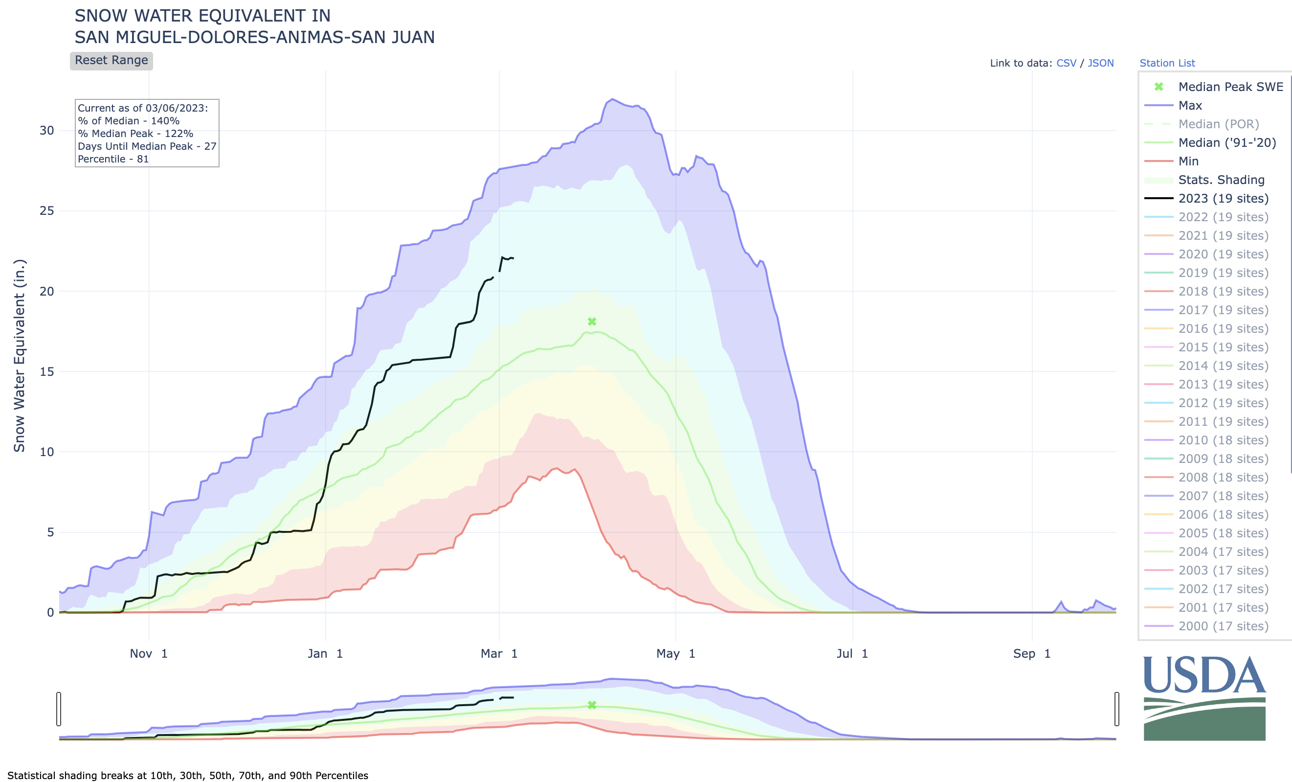
A snow report from Wolf Creek Ski Area dated approximately 6 a.m. on March 1 indicates that Wolf Creek has received 9 inches of snow in the prior 24 hours and 11 inches in the prior 48 hours. According to the report, this brings the midway snow depth to 119 inches and the year-to-date snowfall total to 339 inches. According to the U.S. Department of Agriculture National Water and Climate Center’s snowpack report, the Wolf Creek summit, at 11,000 feet of elevation, had 32.6 inches of snow water equivalent as of 10 a.m. on March 1. TheWolf Creek summit was at 134 percent of the March 1 snowpack median.
The San Miguel, Dolores, Animas and San Juan river basins were at 140 percent of the March 1 median in terms of snowpack.
Now that the 2022-23 meteorological winter is over, it’s safe to say that it was an abnormally wet and snowy winter. Some places in the Sierra Nevada, for example, have seen two to four times the normal amount of snow.
Even southern Californians grappled with blizzards (not normal) and an avalanche was triggered on Mount San Jacinto near Palm Springs (not normal). Silverton, Colorado, was buried in several feet of snow, suffered an hours-long power outage, and was isolated from the outside world when the passes in both directions closed due to avalanches. Two skiers were killed by an avalanche near Vallecito Reservoir in southwestern Colorado. The tragedy was made all the more shocking by the relatively low-elevation (8,400 feet) at which the accident occurred, in a place that normally doesn’t receive enough snow to create significant avalanche hazards.
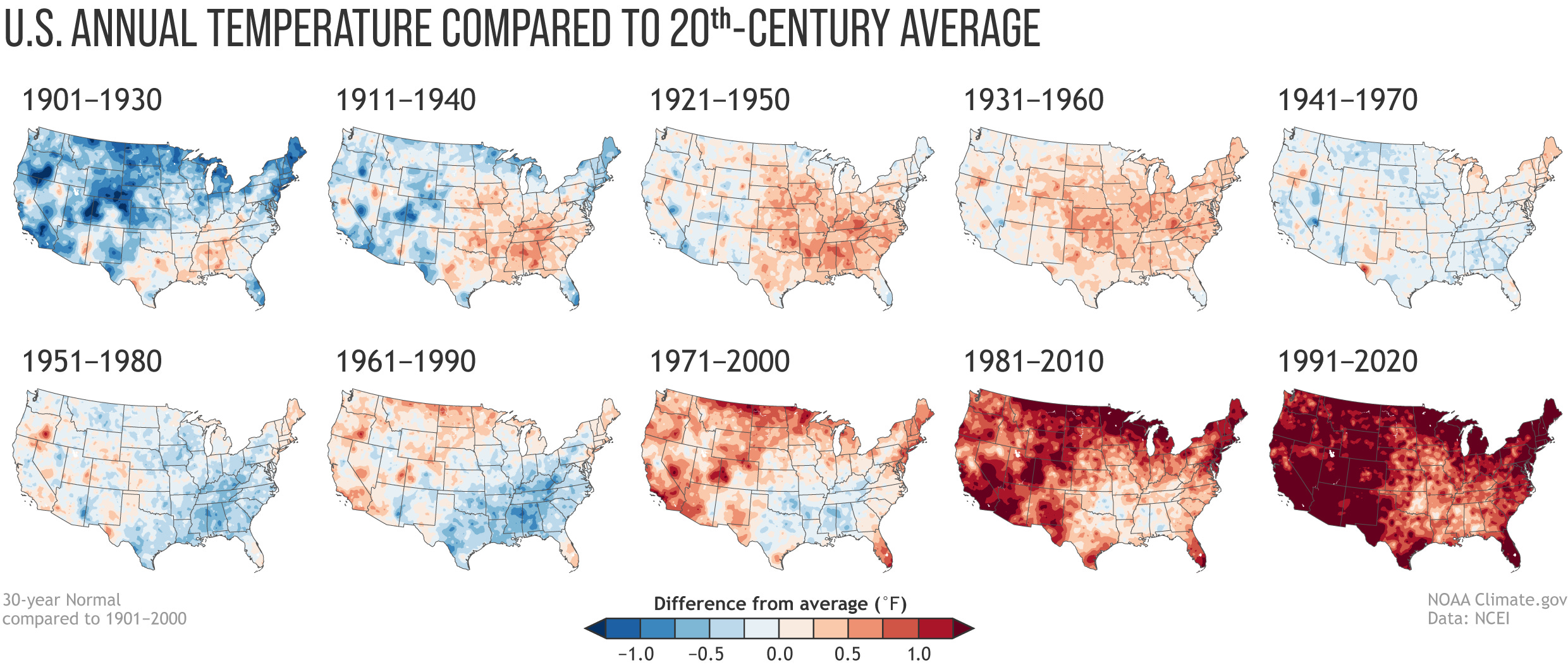
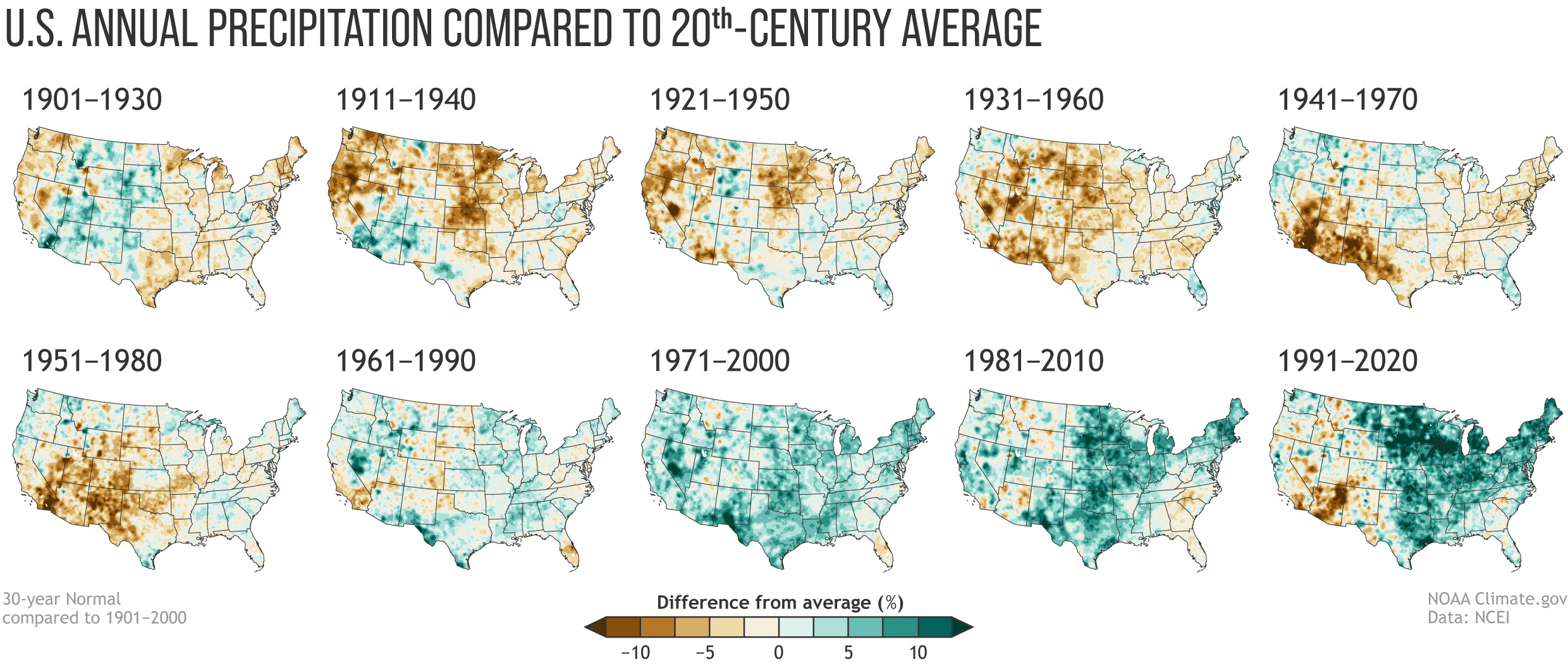
You may have noticed that I used the term “normal” several times in the preceding paragraphs. But what does normal really mean? It seems so subjective, a somewhat derogatory descriptor of something boring. And yet, meteorologists and climate scientists use the term all the time to let us know whether a winter’s snowfall or temperatures fall within an average (or median) historic range or not.
That makes sense. But weirdly, the National Oceanic and Atmospheric Administration determines its normals by looking only at the most recent three decades. So, for example, if one were to say the snow water equivalent at the Spratt Creek SNOTEL station in northeastern California is currently 450% of normal (the actual reading on March 3), they would mean that it’s four and a half times greater than the 1991-2020 median…
That, understandably, irks some folks, since it seems like a rather short period of time to use to define “normal.” Also, if those three decades were, say, drier than the decades that preceded them, wouldn’t that skew things? Why not go back to the beginning of record keeping? The National Weather Service has an answer: the criteria was chosen by the international meteorological community in the 1930s because many countries didn’t have reliable record keeping prior to 1900. So, the thirty-year standard was a bit of an accident of timing, and it stuck.
Which is fine and good but it still leaves me feeling empty, kind of like when I eat a Blake’s Lotaburger and they forget to add the green chile. It just seems far more valuable to be able to compare current conditions to as deep a historic record as possible. The good news is, in addition to using the 30-year normal, NOAA also tracks the 20th century averages, so we can at least easily compare the new normal to the old and compare both to the 20th century average.
IRRIGATED agricultural land in the San Luis Valley is worth $250,000 for 160 acres, or $2,000 per acre-foot of groundwater withdrawn.
At least those are the valuations on irrigated acres that the Rio Grande Water Conservation District board agreed to during a special meeting Tuesday when it debated requirements for farmers and ranchers to apply for a $30 million pool of state money.
The water conservation district board will meet again on Friday, March 3, to formally adopt the requirements.
Developing the criteria to access the $30 million tied to state law SB22-028 and its Groundwater Compact Compliance Fund was a painstaking process for the water conservation district board, which has met for hours and hours over a series of meetings to hash out the requirements.
Cleave Simpson, the architect of SB22-028 and general manager of the Rio Grande Water Conservation District, always said drafting the requirements would prove to be more difficult than getting the legislation adopted, and he was right.
“This whole plan is not easy to understand,” said board member Peggy Godfrey in her pleas for simplicity in drafting the requirements.
The state law is intended to help irrigators in the Upper Rio Grande Basin and Republican River Basin meet their water obligations by retiring irrigated acreage. Each basin has an earmark of $30 million. In the case of San Luis Valley farmers and ranchers, the money has to be spent to permanently retire groundwater pumping wells to help the Upper Rio Grande meet the state’s groundwater pumping regulations and stabilize the two aquifers in the San Luis Valley.
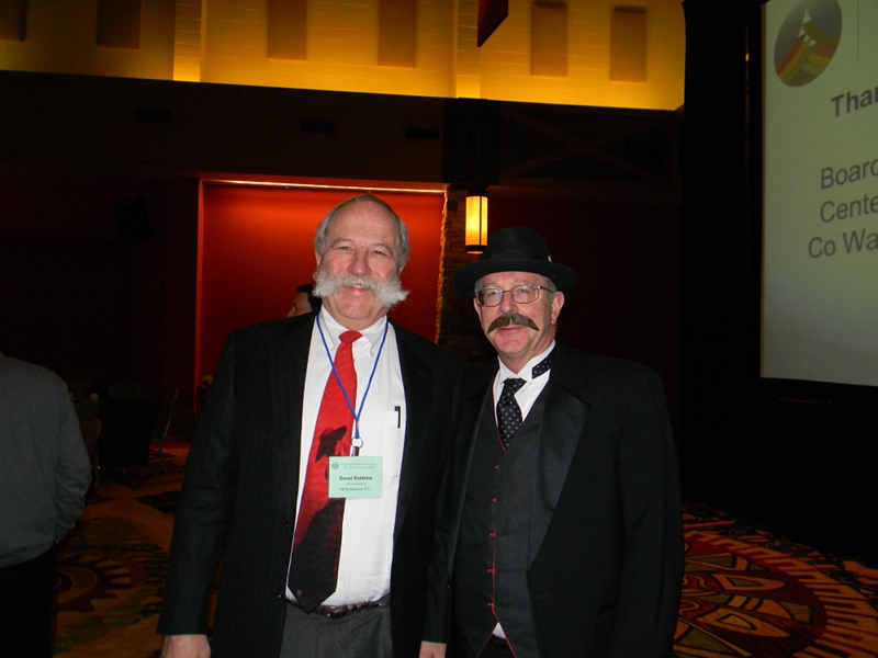
David Robbins and J.C. Ulrich (Greg Hobbs) at the 2013 Colorado Water Congress Annual Convention
David Robbins, the water conservation district’s long-standing attorney, emphasized that the requirements have to result in a “verifiable reduction in groundwater wells.” The state program is essentially a $30 million “buy and dry” for irrigated acres in the Valley, Robbins has said.
Once adopted, the Colorado Division of Water Resources will review the requirements before they go into effect. The state takes at least a month to review and approve the requirements adopted by the water conservation board, according to Robbins.
That means it would be sometime in April and into the spring that the Rio Grande Water Conservation District would begin to accept applications and start to spend down the $30 million earmark. Amber Pacheco, acting general manager, said the water conservation district is already getting phone calls from groundwater well irrigators looking to apply for the money.
Under the state law, any of the $60 million not spent by the Rio Grande Water Conservation District and Republican River Conservation District by Aug. 15, 2024, goes into the state’s kitty for spending. The money is part of Colorado’s federal appropriation of COVID-19 relief funding.
In opting to establish a “base payment” that values a quarter section of irrigated land (160 acres) at $250,000, the board knew that it may overpay on some properties and underpay on others.
“We’re going to hear that,” said board member Steve Keller. “This is where simplicity works against accuracy.”
Ahead of Tuesday’s debate when some revisions were made to the draft, Robbins advised board members to be careful not to advocate for criteria that could benefit their own farm operations. That prompted board member Mike Kruse to recuse himself from the deliberations. Kruse has said he plans to submit an application for some of the $30 million.
The water conservation district board had to account for different sizes of farming operations that may apply for the money. The section on land compensation reads, in part: “Applications that seek to include parcels of property that are either larger or smaller than a standard quarter section (160 acres) will receive a prorated base payment that will rely on the decreed and/or permitted irrigated acres for the serving well(s), using $250,000 for 160 acres as the base. [For example: a half quarter at 80 acres would have a base payment of $125,000 or a parcel of 240 acres would have a base payment of $375,000].”
“I don’t want this $30 million to go away. I want to spend it all,” said Greg Higel, president of the Rio Grande Water Conservation Board.
Once the state approves the requirements, the Rio Grande Water Conservation District will publicize them on its website. A draft of the requirements is posted here, but note that this draft was slightly modified in language in a few sections during Tuesday’s special meeting of the Rio Grande Water Conservation District and is not the final draft.
The Las Vegas Wash is the primary channel through which the Las Vegas Valley’s excess water returns to Lake Mead. Contributing approximately 2 percent of the water in Lake Mead, the water flowing through the Wash consists of urban runoff, shallow groundwater, storm water and releases from the valley’s four water reclamation facilities. Photo credit: Southern Nevada Water Authority
While western states work to hash out a plan to save the crumbling Colorado River system, officials from Southern Nevada are preparing for the worst — including possible water restrictions in the state’s most populous county. The Nevada Legislature last week introduced Assembly Bill 220, an omnibus bill that comes from the minds of officials at the Southern Nevada Water Authority. Most significantly, the legislation gives the water authority the ability to impose hefty water restrictions on individual homes in Southern Nevada, where three-quarters of Nevada’s 3.2 million residents live and rely on the drought-stricken Colorado River for 90 percent of their water…
The bill, if approved and signed into law in its current form, would stand as another substantial step toward conserving Nevada’s tiny 1.8 percent share of the Colorado River, a river that has seen far less water in recent years than what current management plans allow to be taken out between the seven states that rely upon it for drinking water and agriculture irrigation…Under the bill’s current language, the water authority’s board of directors could limit residential water use to as little as 0.5 acre-feet per home annually, or about 163,000 gallons…
The average single-family home in Southern Nevada uses about 130,000 to 132,000 gallons annually, according to the water authority, meaning that such restrictions would be felt more by the valley’s larger residential water users…Such restrictions could be approved by the authority if the federal government declares water shortages in the Colorado River — which has been the case for each of the past two years, and projections for Lake Mead’s water levels show that shortage conditions likely will remain in place into the foreseeable future…
Bronson Mack, spokesman for the water authority, said the change would allow the agency to be more flexible and responsive in dealing with water shortage situations, especially if conditions along the river degrade to a point where the federal government was forced to impose restrictions across the entire basin and significantly limit water deliveries.
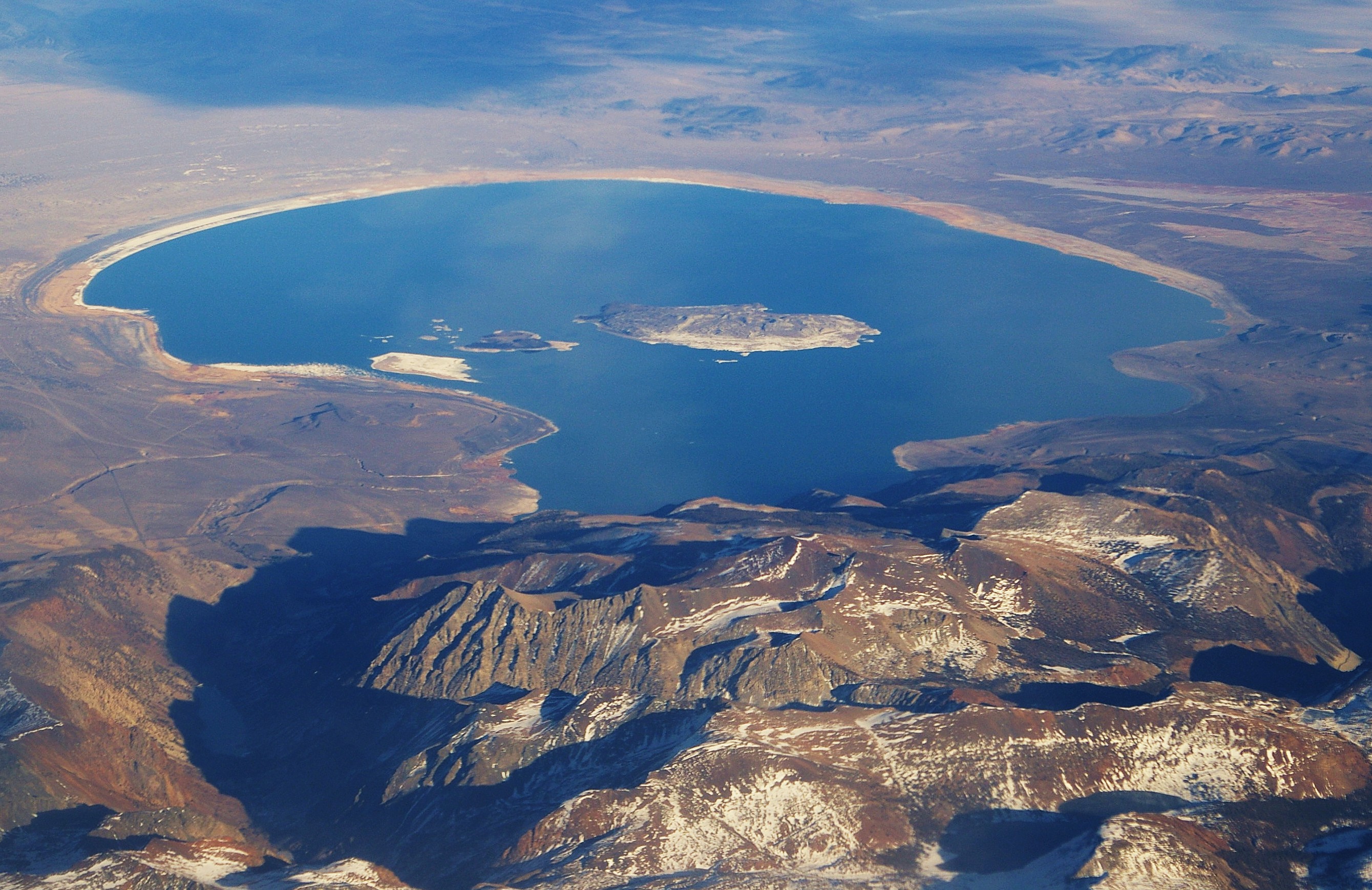
A grove of tufa towers along the south shore of Mono Lake, California, where long-term drought, global warming and water diversions threaten an ancient ecosystem. Credit: Bob Berwyn
The Kootzaduka’a says the state water board should live up to its recently adopted environmental justice promises to save their cultural and natural heritage.
Against the backdrop of a severe drought linked with global warming, conservation advocates and Native Americans in California are calling for a temporary emergency stop to all surface water diversions from Mono Lake, contending that continuing to drain the watershed, along with the long-term drought, threaten critical ecosystems, as well as the Kootzaduka’a tribe’s cultural connection with the lake.
In a pair of letters written in December 2022, the Mono Lake Committee and California Indian Legal Services claimed that Mono Lake’s water has dropped to a level requiring emergency action, and asked that all surface water diversions be curtailed until the lake’s elevation gets closer to an elevation of 6,392 feet. That was set as a protective level for Mono by the state in 1994, but the lake has never come close to reaching it.
The “urgent and developing ecological crisis” threatens Mono Lake with “imminent harm,” Mono Lake Committee executive director Geoff McQuilkin wrote in a Dec. 16 letter to the state’s Division of Water Rights, asking the agency to suspend the “export of water diverted from Rush and Lee Vining creeks from the Mono Basin and requiring delivery of that water into Mono Lake.”
Writing on behalf of the Kootzaduka’a Tribe, which has lived in the area around Mono Lake for thousands of years, California Indian Legal Services attorney Michael Godbe supported the request in a Dec. 22 letter to the state water board. He asked that “alldiversions be halted until the Lake reaches a level of at least 6384’ above sea level, at minimum, in order to prevent further deterioration of the Tribe’s cultural connection with the lake.”
Los Angeles Denies Emergency
The Los Angeles Department of Water and Power, which drained Mono Lake’s ecosystem by diverting its tributary streams, responded to the Mono Lake Committee’s ecological concerns in a Jan. 11 letter to the board, but did not address the Kootzaduka’a Tribe’s concerns about its cultural connections to the unique watershed.
“First and foremost, no ‘emergency conditions’ exist that would warrant an emergency regulation,” senior assistant general manager of LADWP’s water system Anselmo Collins wrote. The actions proposed by the Mono Lake Committee would “likely violate LADWP’s procedural and substantive rights,” he added.
Mono, an ancient salt lake, is located in the high desert of Eastern California and replenished by several freshwater streams flowing out of the Sierra Nevada Mountains. The inflowing stream water maintained a balanced ecosystem for at least 1 million years, nurturing breeding and feeding birds, as well as Indigenous people, for millennia.
That balance was disrupted in 1941 when Los Angeles started diverting millions of gallons of water from the watershed every year and sending it 300 miles south for municipal use through the Los Angeles Aqueduct without due consideration of Indigenous water rights or environmental protection.
A science-based grassroots effort to protect the lake started in the 1970s, and in 1983, the California Supreme Court ruled that Mono Lake’s public trust values must be considered in making decisions about allocating waters in the Mono Lake Basin, which includes the tributary streams.
A Los Angeles Department of Water and Power diversion dam on Lee Vining Creek, one of places where the city blocks flows to Mono Lake and shunts water 300 miles south through an aqueduct. Credit: Bob Berwyn
About 10 years later, the state water board finalized a restoration plan that limits diversions. It requires specific seasonal stream flows to rehabilitate streams, and also mandates that Mono must rise to an elevation of 6,392 feet, the lowest level deemed protective of the lake’s ecosystem.
The 1994 plan said the lake would reach that level in 20 years, but it was based on projections made before global warming started shriveling the Sierra Nevada snowpack with a multiyear drought.
And it was finalized without meaningful consideration of the lake’s value as a cultural resource for the Kootzduka’a Tribe, Godbe wrote in his letter to the board. Prompt action is critical to protect the tribe’s “previously unconsidered” connection with the lake, he added.
Mono Lake and the five creeks that feed it have “indisputable cultural significance for the Mono Lake Kutzadika’a people,” he wrote. “In the words of the Tribe, ‘Kootzabaa’a (Mono Lake) is the physical, cultural and spiritual center of the Kootzaduka’a people.’”
The tribe’s position is that Los Angeles should not be allowed to continue to divert water each year “when the lake has failed to even once” reach the mandated level, “and all diversions must immediately cease until the Lake rises out of its current crisis.”
The tribe has about 90 members, mostly living around Mono Lake and in the wider region, and the cultural history of its subsistence relationship with the lake has been continuously passed down by tribal elders from generation to generation to the present. It’s been well-documented by historians, Godbe wrote.
The collective gathering of the brine fly pupae that the tribe call kootzabe from Mono’s groves of spiky tufa—rocky spires that rise from the water—plays a central role in that history. The life cycle of the brine flies is intimately linked with the level of the lake and the freshwater flowing, because it’s the combination of those two things that form the tufa towers upon which the flies lay their eggs.
“These tufa grove shallows are where the Tribe harvests kootzabe, as waves dislodge the puparium from the columns so that they float in the shallows and become available for harvest,” the tribal letter to the water board explained. “However, when the lake level recedes below the bottom of the tufa column, the flies cannot go underwater to lay eggs, and the Tribe cannot then harvest the fly pupae in the shallows.”
The abundance of kootzabe was “life-sustaining to tribal members, who relied on the processed fly pupae as a source of protein to get them through the long cold winters,” but all previous mandates on stream flows and lake levels have “failed to formally or meaningfully involve the Tribe,” Godbe wrote.
Mono Lake, located in the eastern foothills of the Sierra Nevada mountains, east of Yosemite National Park. Paoha Island in the middle of the lake. By Ron Reiring – Mono Lake, CAUploaded by X-Weinzar, CC BY 2.0, https://commons.wikimedia.org/w/index.php?curid=11269094
A series of Pacific low pressure and frontal systems moved across the western contiguous U.S. (CONUS) during this U.S. Drought Monitor (USDM) week (February 22-28). The weather systems dropped copious amounts of rain and snow across the West, especially over the Sierra and coastal ranges and Rocky Mountains. The weather systems re-intensified as they crossed the Plains and into the Midwest, tapping Gulf of Mexico moisture to spread several inches of rain over northeast Texas to the Appalachians and Ohio Valley, with several inches of snow falling in the below-freezing air across the northern tier states from the Dakotas to New England. A high-pressure ridge over the Gulf of Mexico generated a southerly flow that spread warmer-than-normal air from the Gulf Coast to southern Great Lakes. It also pushed the low-pressure systems along a storm track that went northeastward from the southern and central Plains to the Great Lakes. Temperatures averaged cooler than normal across the snowy northern states, across the central to northern Plains, and over the West. Little to no precipitation fell across the Gulf Coast, western portions of the southern and central Plains, and over the northern Plains near the Canadian border. It was also drier than normal over parts of the Pacific Northwest, northern New England, and the Mid-Atlantic states. Wetter-than-normal conditions were widespread across the rest of the West, parts of the northern and central Plains and Northeast, and much of the Midwest. Drought or abnormal dryness expanded where it continued dry in parts of Texas, Florida, and other Gulf Coast states. Drought or abnormal dryness contracted or reduced in intensity where it was wet across much of California and other parts of the West and Plains, as well as part of the Great Lakes region…
The High Plains region experienced a patchwork pattern of precipitation this week. The Rocky Mountain areas of Wyoming and Colorado, as well as the eastern half of Kansas, received half an inch to locally 2 inches or more of precipitation, and half an inch fell across South Dakota and northern and eastern parts of Nebraska. But North Dakota, eastern Colorado, and adjacent parts of Kansas and Nebraska were drier, receiving less than half an inch. This winter has been particularly wet for central to northern portions of the High Plains region, while Kansas and parts of southeast Colorado have missed out on the above-normal winter precipitation. The heat and dryness of last summer and fall dried out soils, and as winter set in the soils froze in the northern states, locking the dryness into place. The precipitation this week and earlier weeks resulted in contraction of moderate to severe drought in the Dakotas to Nebraska, and exceptional drought in Nebraska, but abnormal dryness was kept to reflect the leftover dry state of the frozen soils. Abnormal dryness contracted in parts of Colorado and Wyoming, and abnormal dryness and moderate to exceptional drought contracted in eastern Kansas…
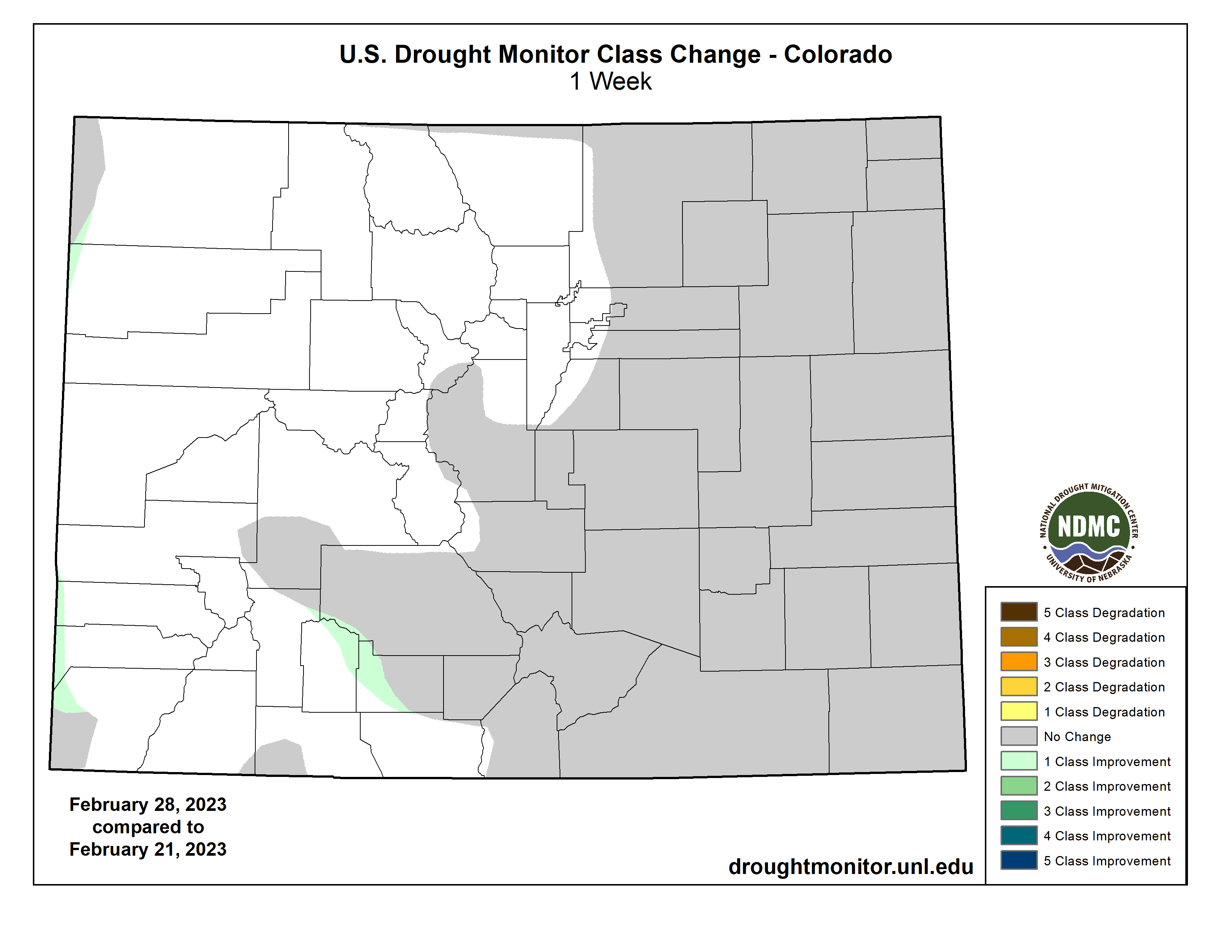
Colorado Drought Monitor one week change map ending February 28, 2023.
Much of the western CONUS has suffered from episodes of drought since 1999. The most recent drought episode has lasted up to 3 years. The lack of precipitation was accompanied by excessive heat, which increased evapotranspiration and further dried soils. The prolonged drought lowered groundwater and reservoir levels. The Pacific weather systems of this week and last week added to copious precipitation that has been received from atmospheric rivers since December 2022, especially over California and states to the east. The coastal mountain ranges, Sierra Nevada, and central to southern Rockies received 2 inches or more of precipitation this week, with totals exceeding 5 inches in parts of California. The heavy rains this week resulted in widespread flash flooding in parts of California. Some interior parts of the West had half an inch or more of precipitation, but favored rainshadow areas received less than a fourth of an inch. According to SNOTEL observations, 4 feet or more of new snow fell across the Sierra Nevada range this week. The SNOTEL station at Css Lab reported 78 inches of new snow, bringing the total snow depth to 178 inches as of February 28. Mt. Rose Ski Area reported 178 inches of snow on the ground, Ebbetts Pass reported 176 inches, and Echo Peak had 172 inches. The Hanford, California, area received 9.59 inches of precipitation during December 1, 2022-February 26, 2023. This is the third highest amount for the December 1-February 26 period in the 1900-2023 history for the Hanford area. The rain has improved California soil moisture and streamflow levels, while the snow has increased mountain snowpack to much above-normal levels. Most California reservoirs have refilled with water levels near or above average, but groundwater levels remain low and may take months to recover. Abnormal dryness and moderate to severe drought were contracted across much of California to reflect the above-normal precipitation of recent months, above-normal snowpack, and improved reservoir levels. According to USDM statistics, central California’s Sierra Nevada mountains and foothills are now free of drought and abnormal dryness for the first time since January 2020. Abnormal dryness and moderate to extreme drought were trimmed in Montana, abnormal dryness and moderate to severe drought contracted in New Mexico, and abnormal dryness and moderate drought were pulled back in Arizona. Soil moisture and mountain snowpack have improved in Utah, but groundwater and many reservoirs continue at very low levels. Abnormal dryness and moderate to severe drought were trimmed in Utah in areas where reservoir levels have improved sufficiently. The precipitation in the Pacific Northwest, especially Oregon, was not sufficient to warrant improvement in the drought depiction. In Oregon, reservoirs remain depleted at record to near-record low levels. The southwest Oregon reservoirs have improved only a couple percent over the last two weeks: Emigrant reservoir’s level rose from 21% full on February 16 to only 22% full by February 27; Hyatt increased from 14% to only 15%; Howard Prairie from 17% to 18%; and Agate from 35% to 37%…
Two inches or more of precipitation fell in strips across Arkansas and eastern Oklahoma, with half an inch or more stretching from northeast Texas to Tennessee. But little to no precipitation fell across western and southern areas of the region. Abnormal dryness and moderate to extreme drought were trimmed in parts of eastern Oklahoma and north-central Texas, but abnormal dryness expanded along the Gulf Coast in Louisiana and Mississippi. Abnormal dryness and moderate to extreme drought expanded in parts of the southern half of Texas as streamflow, soil moisture, and groundwater continued at very low levels. High winds, low humidity, and hot temperatures continued to dry out the soils. Two years of drought in the southern Plains were capped this week by raging dust storms. The continued dry weather, and now 100+ mph winds with low humidity, have desiccated crops, with the media reporting that the dryland wheat crop in parts of Texas, Oklahoma, and Kansas could see abandonment rates up to 80%…
Looking Ahead
As this USDM week ended, one weather system was moving across the Northeast and another was slamming into the West. More Pacific weather systems will follow during March 2-7, bringing half an inch or more of precipitation to the West Coast and higher elevations of the West, parts of the Great Plains, and much of the CONUS to the east of the Plains. Another 4 inches or more of precipitation can be expected for the Sierra Nevada and coastal ranges, and from northeastern Texas and eastern Oklahoma to the Ohio Valley and southern Appalachians. An inch or more of precipitation should be widespread from eastern Kansas to the southern Great Lakes, and from the eastern Great Lakes to the Northeast and Mid-Atlantic states. Western and some central parts of the Great Plains, especially Nebraska, western Texas, and southeast New Mexico, as well as southern California to the Great Basin, are forecast to receive less than half an inch of precipitation. Temperatures are predicted to be warmer than normal in the south and southeast to cooler than normal in the West. A cooler- and wetter-than-normal pattern is likely for March 8-15 across the CONUS. The Gulf of Mexico coast and much of Alaska likely begin this period warmer than normal, but odds favor cooler-than-normal temperatures as the period progresses. At the beginning of this period, below-normal precipitation is favored in the Northeast and Great Lakes, but below-normal precipitation is expected to dominate the southern half of Alaska through the period.
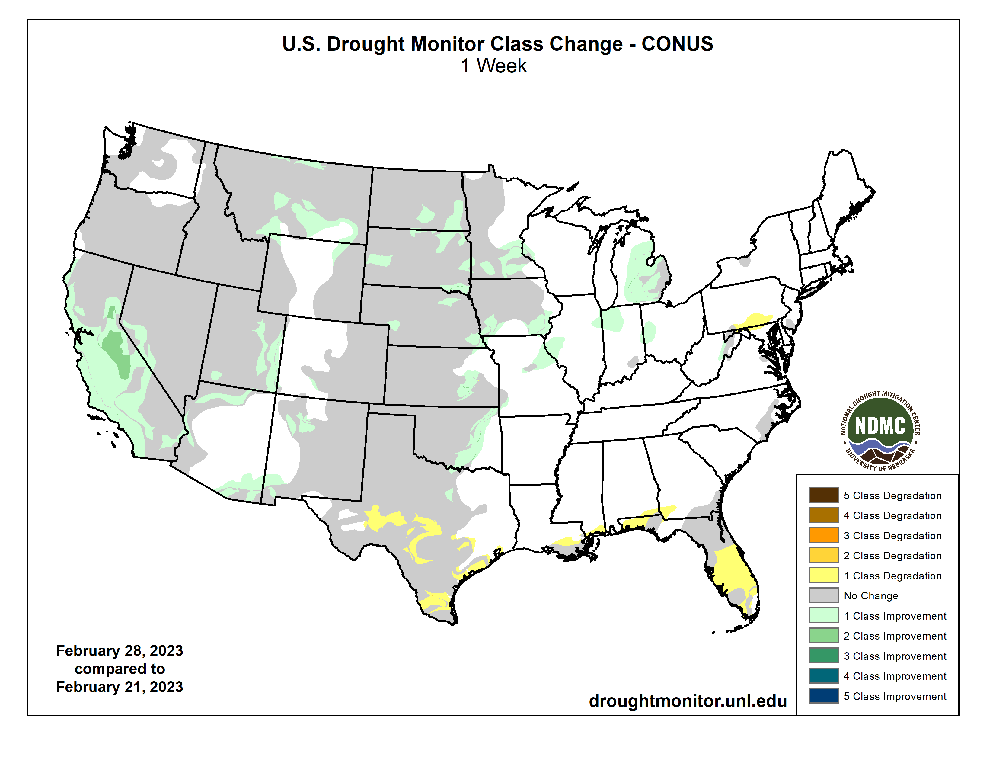
US Drought Monitor one week change map ending February 28, 2023.
Homestake Reservoir circa 2010. Photo credit Aurora Water.
Click the link to read the article on The Denver Post website (Saja Hindi). Here’s an excerpt:
Aurora residents will have to decrease their lawn watering use by one day starting May 1 because of low water storage levels — the city is likely the first in Colorado to make such a decision so far this year. The reservoir levels are projected to get to about 48% capacity by mid-April, triggering the city’s Stage 1 drought restrictions. The City Council passed a declaration to move to “Stage 1 Water Availability” at a meeting earlier this month. Members also voted on first reading, 9-1, to implement a surcharge on lawn watering. A final vote is expected Monday, and the plan has received little opposition from members.
Residents will receive letters from the city’s water department alerting them to which days they can water their lawns, down from three to two — even-numbered home addresses will have different days than odd numbers and the department will advise residents to water within certain hours. Any properties that have watering variance allowances for irrigation will also have to reduce their consumption. Multifamily and commercial properties without irrigation variances will need to restrict watering to twice a week as well. City officials say that residents’ water bills should remain the same as their bills from last summer (when they could water three times a week) even with the surcharge in effect as long as they stick to watering their lawns twice a week. If they go beyond that, they could see higher costs that will make their bills go up…
The goal is to reduce outdoor water use by 20% citywide — officials hope the surcharge will incentivize lower use — and these restrictions would remain in effect until the City Council approves a change. If water conditions improve, city staff says the restrictions will be lifted.
Northern Water is embarking on a new source water protection program to safeguard the high-quality water that comes from the watersheds that supply water to the Colorado-Big Thompson (C-BT) and Windy Gap projects, as well as the Northern Integrated Supply Project, and to reduce the risk of contamination of our water sources. Our source water program includes an initial planning phase, and we have begun the process of developing a strategic source water protection plan (SWPP) to help guide our efforts.
By developing a SWPP, we will be part of a state and nationwide effort to protect water sources from the ground up. At the state level, Colorado’s Source Water Assessment and Protection (SWAP) Program is a voluntary program designed to help public water systems take preventative measures to keep their sources of drinking water free from potential contaminants. The SWAP program came about due to the 1996 Safe Drinking Water Act amendments.
By developing a SWPP, we will be part of a state and nationwide effort to protect water sources from the ground up. The typical development of a SWPP involves identifying a source water protection area(s), creating an inventory of potential contaminants to the water sources, and subsequently developing best management practices to help mitigate those potential contaminants. We anticipate that the SWPP development and process will span a few years and are currently kicking off the first phase with outreach to key constituents. Following the completion of our SWPP, we will move into the implementation phase which will involve execution of the BMPs identified in our SWPP.
We will be communicating with various stakeholders throughout the process and providing periodic updates of the plan throughout various channels. Once the SWPP is finalized, it will be made available to the public via our website.
If you have any questions or comments about this process, please contact Kimberly Mihelich, Source Water Protection Specialist by emailing kmihelich@northernwater.org or calling 970-622-2211.
To help watersheds recover quickly from catastrophic wildfires, federal and state funds need to be available continuously, rather than on an as-needed basis, and water districts and local governments need to be shielded from the liability that normally comes when working with federal wildfire recovery programs, according to a new report.
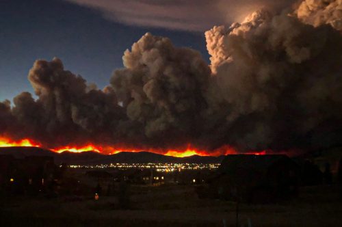
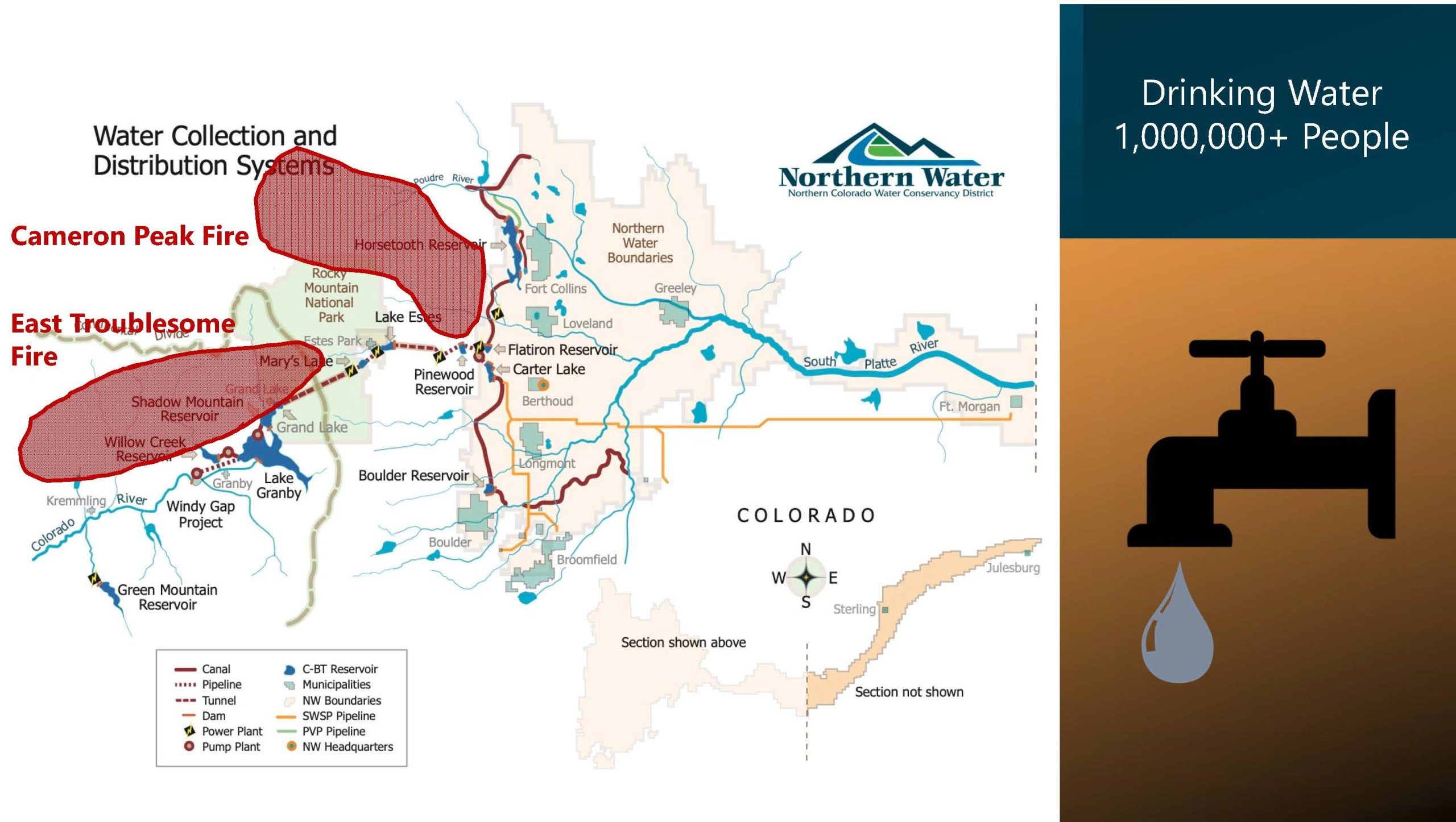
The draft report, 2020 Post-Fire Watershed Restoration: Lessons Learned, was presented two weeks ago at the annual convention of the Colorado Water Congress in Aurora. It focused on the post-fire recovery response to the East Troublesome and Cameron Peak fires in 2020. The fires are the largest in Colorado history and engulfed Northern Water’s system in Rocky Mountain National Park as well as water systems that serve Fort Collins, Larimer County and the city of Greeley. Those systems deliver water to more than 1 million people on the northern Front Range and help irrigate hundreds of thousands of acres of farmland.
Source: Northern Water
“Having predictable annual funding for wildfire recovery is urgent because these events are going to happen,” said Esther Vincent, who led the report team and who serves as director of environmental services at Northern Water.
After the two fires were contained, local communities and water districts began working quickly using funding from the U.S. Department of Agriculture’s Emergency Watershed Protection (EWP) Program. But that federal fund is replenished on an as-needed basis and is used by all 50 states when disasters occur. When it runs out, as it sometimes does, it can take years for Congress to approve more cash.
“Waiting until there is enough political will is an inefficient way to fund the EWP Program,” said Sean Chambers, who also served on the report team and who is the director of water and sewer utilities for the City of Greely. Greeley coordinated much of the recovery work on the Cameron Peak Fire.
“When we started recovering from Cameron Peak there was money available and we were able to start immediately addressing some high-risk slope stability issues on tributaries, around reservoirs, on private property. But then we ran out of money,” Chambers said.
More money was found in the EWP Program by asking other states to turn over unused funds, but it took months during a critical time window when the watershed restoration teams only had a few weeks to work before the burn scars were covered with snow and became inaccessible, Chambers said.
Nearly $70 million has been spent on the Emergency Watershed Protection (EWP) programs used to recover from these 2020 fires. The Natural Resources Conservation Service (NRCS) provided the majority of the funding, with local sponsors contributing matching funds. Source: Northern Water
Another issue that hampered the immediate post-fire recovery effort is the liability that must be assumed by those who partner with key federal programs that provide funding, including the EWP Program.
Northern’s Vincent said the Northern Water Board was deeply concerned about assuming the liability, which requires local partners to assume full financial responsibility for the work, which can cost millions of dollars. But ultimately the board agreed to do so.
As a result, the report recommends that Congress remove the liability requirement from its disaster contracts and also suggests that a new insurance pool be created to limit the liability of restoration partners, according to Peggy Montaño, an attorney who serves as Northern’s legal counsel and who also served on the report team.
Todd Bolt is the state coordinator of the EWP Program and a member of the work group that wrote the report. He declined to comment on the federal funding and liability recommendations, but he said the report was “eye-opening.”
“It brought a lot of people together who have first-hand experience, state, federal, local. And it has opened everybody’s eyes that there are things we can do better with the post-fire effort in Colorado,” Bolt said.
Two additional recommendations that the report makes are to streamline data collection and modeling analyses and to refine them so that they can be used to make decisions faster. The second is to have “local navigators,” who are trained and ready to help immediately after a fire.
More than a half dozen agencies can be on the ground post-fire, gathering data and trying to understand what might happen with rain storms, sediment loads and debris flows. But agencies often use different parameters for collecting the data they use in their modeling. Some, for instance, might use only the burn area itself for modeling, when a broader watershed boundary is needed to understand what’s happening on streams above and below the burn scar.
Fire-stained debris from the East Troublesome fire gathers in Willow Creek Reservoir. It is part of Northern Water’s collection system. Source: Northern Water
Northern’s Vincent said there were so many different modeling and data collection efforts underway that it made it difficult to know which would be the best to use.
“Bringing all of this information together and digesting it when you are the practitioner on the ground and you have to make decisions about what these models mean and what mitigation strategies are going to work is difficult. We were swimming in this downpour of modeling outputs, with little guidance and understanding of ‘OK this is where we have a problem. This is where we need to take action and do mitigation.’”
Bolt said that a “local navigator” program would specialize in connecting local residents and local governments with the resources they need to begin restoration work post-fire.
“Someone who could lead them through the process would be helpful,” he said.
Looking ahead, report authors plan to share their findings with lawmakers and others who are working on protecting Colorado from the wildfires they say are sure to come.
“No matter how successful we are with forest management and helping our watersheds be more resilient, it is going to take a long time to do the projects that need to occur at a landscape scale,” Vincent said. “We are still going to have devastating, large-scale megafires. We need to focus on paths to being prepared and getting better at the post-fire recovery process.”
Jerd Smith is editor of Fresh Water News. She can be reached at 720-398-6474, via email at jerd@wateredco.org or @jerd_smith.
The East Troublesome fire as it tore through the Trail Creek Estates subdivision on Oct. 21, 2020. (Brian White, Grand Fire Protection District)
Groups call for CDPHE to issue strongest possible water discharge permit for refinery
DENVER, CO —
A new study conducted by Westwater Hydrology LLC connects PFAS pollution in Sand Creek and the South Platte River, as well as river water used by Commerce City, Brighton, Thornton, Aurora, and other municipal drinking water systems, to the Suncor refinery in Denver. The study found that Suncor’s 2021 discharges from just one outfall, 020, account for 16-47% of the total PFAS loading in Sand Creek and 3-18% of the total PFAS loading in the South Platte.
Municipalities, including Commerce City, Brighton, Thornton, and Aurora, utilize water intake wells along the South Platte downstream of Suncor. Due to the hydrology of the river and the underlying aquifer, any PFAS in the river gets drawn into the drinking water system when it enters these intake wells. The South Platte is also a major source of agricultural irrigation water; Suncor’s PFAS pollution is likely taken up by crops, creating another exposure point for the humans and animals that consume them.
“The communities surrounding the refinery have faced disproportionate health impacts and threats from Suncor for far too long,” said Caitlin Miller, senior associate attorney with Earthjustice’s Rocky Mountain office. “This facility continues to pollute the air that people breathe and the water that they drink with relative impunity. It is time for the Colorado Department of Public Health & Environment (CDPHE) to issue the strongest possible water discharge permit that prohibits Suncor from discharging any more PFAS.”
The PFAS levels studied at Outfall 020 do not account for additional pollution from Suncor’s other outfalls, including process water and stormwater outfalls, which only add to the overall impacts to Colorado’s waterways and drinking water.
CDPHE’s Water Quality Control Division has put forth a draft water permit that reduces the amount of PFAS that Suncor can discharge but fails to limit it to levels that are safe. Suncor installed a temporary treatment system in October 2021 to reduce its PFAS discharges at Outfall 020, but even with these measures in place, the pollution remains at toxic levels according to updated toxicity assessments from the Agency for Toxic Substances and Disease Registry (ATSDR) and the U.S. Environmental Protection Agency (EPA).
In its initial comments on the draft permit, Suncor requested that CDPHE dramatically weaken the pollution limits and monitoring requirements in its final permit for multiple pollutants, including PFAS.
“We have endured pollution to our sources of life through environmentally-racist policies in Commerce City for so long without restoration that even state and federal agencies have normalized trauma to our communities without protection or regulation from extractive industries,” said Renée Millard-Chacon, co-founder and executive director of Womxn from the Mountain, an Indigenous Womxn-led nonprofit based out of Commerce City. “However, we are all connected, and it is never okay to harm disproportionately impacted communities this way, including our future generations, without respecting our right to live and thrive without severe environmental degradation for an economic gain that has never benefited residents’ health.”
PFAS are toxic pollutants that persist in our bodies and the environment for decades. Drinking water is one of the most common routes of exposure to PFAS. Studies of the best-known PFAS have shown links between the chemicals and kidney and testicular cancer, as well as endocrine disruption in people.
The EPA recently objected to Suncor’s draft Title V air permit, finding that CDPHE failed to scrutinize changes to the company’s operations, including those that allow the company to emit even more harmful pollution into surrounding communities. EPA’s objection directs CDPHE to no longer rubberstamp proposed changes to the refinery’s operations.
When it was released, the Westwater Hydrology report indicated that South Adams County Water and Sanitation District (SACWSD) had at least one intake well – Well 119 – impacted by Suncor’s PFAS discharges. It found that these PFAS discharges could therefore impact Commerce City drinking water. Since releasing the report, we have learned and verified that this well is not hooked up to SACWSD’s general municipal supply, but rather provides underground irrigation water for portions of Commerce City.
SACWSD has created a dual water system for its northern service area where one set of water infrastructure supplies potable drinking water and another separate system supplies non-potable underground irrigation water. Irrigation water, including irrigation water for domestic use, in the area north of 96th Avenue and east of Highway 2 is impacted by Well 119. This remains a concern if residents use the water for home vegetable or fruit gardens.
The new information about Well 119 does not change any of the other conclusions in the report.
Colorado- Governor John Hickenlooper on Feb. 26, 2012. USDA Photo by Lance Cheung.
Click the link to read the article on the KUNC website (Alex Hager):
Senators from the seven Western states that use water from the Colorado River have been convening to discuss its future. John Hickenlooper, a Democrat from Colorado, spearheaded the caucus and said the group has been meeting for “about a year,” though news of its existence only recently became public. The caucus meets as a growing supply-demand imbalance threatens the water supply for 40 million people in the Southwest and a multibillion-dollar agricultural industry…
“Our role is not to take the place of the state water councils or the state governors,” Hickenlooper said. “It is really to facilitate and try to create an environment where we can find the right compromise and be able to use collaboration and cooperation in such a way that we create as little hardship, as little sacrifice for the farmers and ranchers of the Colorado River basin as possible.”
[…]
Hickenlooper said the caucus is designed to help bridge gaps between states that have been at odds over how to share the Colorado River’s water. Efforts to agree on cutbacks to water use are often hamstrung by the river’s varied users and esoteric legal structure…Hickenlooper said the caucus is unlikely to draw up a federal law that would change water allocations, but could still produce some actionable steps, such as legislation to help states incentivize more efficient water use.
Click the link to read the article on the NOAA website (Nat Johnson):
Another meteorological winter is drawing to a close, though it feels like some of us in the East are still waiting for winter to arrive (not a single inch of snow here in central New Jersey so far!). I realize that this winter has been more eventful in other parts of the country, notably in the western U.S., where torrential rains and heavy mountain snows occurred in December and January. Such heavy precipitation was unexpected prior to the season in a region afflicted with a multi-year severe drought, especially given that we are in the third consecutive winter of La Niña. How unusual were these Southwestern wet conditions in the first two-thirds of a La Niña winter? And did tropical sea surface temperatures contribute? In this blog post, I hope to get this conversation rolling!
Percent of normal U.S. precipitation over the past 30 days (December 25, 2022, through January 23, 2023) after a series of weather events known as atmospheric rivers, fueled by tropical moisture, flooded the U.S. West with rain and snow. Places where precipitation was less than 100 percent of the 1991-2020 average are brown; places where precipitation was 300 percent or more than average are blue-green. NOAA Climate.gov image, based on analysis and data provided by the Climate Mapper website.
Western drenching
As the figure above shows, much of the western U.S. was pummeled from late December through mid-January, as a series of nine atmospheric rivers dumped more than a season’s worth of rain and snow in a few short weeks. The relief from an unrelenting drought was welcome, but too much of a good thing also meant flooding, mudslides, and dangerous debris flows.
Average December–January precipitation anomalies (percent of the 1991-2020 climatology) for all La Niña events from 1951-2020, defined as La Niña occurring in December–February. Places where precipitation was less than the 1991-2020 average are brown; places where precipitation was above average are blue-green The white box defines the Southwest U.S. region (32° – 40° N, 109°-125° W) that is the focus of further investigation. NOAA Climate.gov image, based on precipitation data from NOAA’s Precipitation Reconstruction over Land (PREC/L).
This atmospheric river onslaught surprised many who were expecting a dry season, especially in the Southwest, not only because of the prolonged drought, but also because La Niña tends to bring drier-than-average winter conditions to the region. Here, I am focusing on the Southwest region south of 40 °N that covers most of California, Nevada, Utah, and Arizona, in early winter (December–January). The figure below shows that most (13 of 21) of the La Niñas from 1951-2020 had below-average December-January precipitation in this region (1), although wet early winters during La Niña clearly are not that unusual. This early winter, the Southwest had 65% more precipitation than normal according to this precipitation dataset, which is the second highest La Niña total since 1951. The bottom line is that La Niña may tilt the odds toward dry early winter conditions in the Southwest, but La Niña clearly does not eliminate the chance of wet conditions either.
Distribution of December–January precipitation anomalies (percent of the 1991-2020 climatology) in the Southwest U.S. (region defined in the figure above) for all 21 La Niñas from 1951-2020. The precipitation anomalies are divided into 10 evenly spaced bins, and the number of La Niña events is totaled for each bin. The brown bars indicate events with below-average precipitation, and the green bars indicate events with above-average precipitation. This figure indicates that the Southwest December-January precipitation was below the 1991-2020 average in 13 of 21 La Niñas during the period. NOAA Climate.gov image, based on precipitation data from NOAA’s Precipitation Reconstruction over Land (PREC/L).
Was it predictable?
The million-dollar question for seasonal forecasters and climate scientists alike is whether this unusually wet Southwestern U.S. could have been anticipated more than a few weeks in advance. This question often boils down to whether there were subtle variations in the sea surface temperature pattern that preconditioned the atmosphere for wetter-than-usual conditions in the region (2). These variations include the magnitude and location of the strongest tropical Pacific sea surface temperature anomalies—a particular “flavor” of La Niña.
One way we could try to address this question is to group both the wettest and driest La Niñas over the Southwest in December-January and then see if there are notable differences in the sea surface temperature patterns that occurred during wetter La Niñas versus drier La Niñas. The problem with this approach, however, is that our record of reliable observations is just too short to slice and dice the data in this way. We don’t end up with enough events in each group, and the noise of chaotic weather variability hides the signal we are trying to identify.
A common approach to overcome this limitation of not enough real cases is to use global climate models to create hypothetical ones. We can run multiple simulations in which the ocean is always the same—forced to match observed sea surface temperatures, including all La Niñas from 1951-2020—but the starting atmospheric conditions are very slightly different each time. Since the ocean is the same in all the simulations, the models will produce a range of outcomes that account for the role of atmospheric chaos for each individual La Niña. When we average across all outcomes, we filter out the effects of chaotic climate variability (3).
30 alternate realities
For this analysis, I am using simulations of monthly climate from the Geophysical Fluid Dynamics Laboratory (GFDL) climate model called SPEAR, the same model that contributes seasonal forecasts to the North American Multi-Model Ensemble (NMME), but here the experiment is designed to analyze the climate effects of the observed sea surface temperature evolution from 1951-2020 (4). This set consists of 30 simulations, and since there are 21 winter La Niña events between 1951-2020, I have 30 x 21 = 630 simulations of December-January La Niña conditions—a much larger sample size than if I just relied on the 21 observed La Niña winters.
Difference in December–January precipitation anomalies (percent of the 1991-2020 climatology) between the wettest 20% and driest 20% of Southwestern U.S. La Niña outcomes simulated by the GFDL SPEAR climate model. The climate model produces a total of 630 possible climate outcomes covering all La Niñas from 1951-2020. This figure indicates that SPEAR produces very wet early winter conditions in the Southwest for some of the La Niña simulations, with the largest differences between the wet and dry groups exceeding twice the 1991-2020 climatology (more than 200%). NOAA Climate.gov image, based on precipitation data from the NOAA GFDL SPEAR climate model.
To analyze the effect of different sea surface temperature patterns on early-winter precipitation in the Southwest during La Niña, I first defined two groups: the wettest 20% and driest 20% of simulations. The figure above shows the high-minus-low precipitation average differences between these two groups. This figure confirms that SPEAR simulates very high Southwest U.S. precipitation totals in December-January in at least some of the simulated winter La Niñas. The question is, what’s different about those years?
Difference in December–January sea surface temperature anomalies (° C) between the wettest 20% and driest 20% of Southwestern U.S. La Niña outcomes simulated by the GFDL SPEAR climate model. The notably small sea surface temperature differences between the wet and dry groups indicate that the sea surface temperature pattern plays a very minor role in the Southwest precipitation differences during La Niña, according to the climate model. NOAA Climate.gov image, based on precipitation data from the NOAA GFDL SPEAR climate model.
We know that all La Niñas feature below-average surface temperatures in the central and eastern equatorial Pacific, by definition, but the details vary from event to event. So, next, we want to know if there are any consistent differences in the sea surface temperature pattern between La Niñas that lead to wet versus dry early winters in the Southwest. The figure above shows the sea surface temperature differences between the high- and low-precipitation groups in the SPEAR simulations. If you’re struggling to identify any meaningful sea surface temperature differences in the map above, then you and I are in the same boat (5).
The pattern in the map is very weak, with very small departures between the two groups. The logical conclusion is that, according to the climate model, unusually heavy Southwest U.S. precipitation during December-January of La Niña has very little to do with the sea surface temperatures and instead is more closely tied to short-term and seasonally unpredictable weather conditions, as captured by the variations among the 30 simulations for a given La Niña.
To solidify this conclusion, I continued my investigation by calculating how much the variations in the La Niña sea surface temperature pattern contribute to the variations in Southwest U.S. December–January precipitation in the SPEAR simulations. I first averaged the 30 simulations for each of the 21 La Niña winters, giving me 21 precipitation outcomes. These represent the range of variation when the only thing we’re taking into account is “it’s a La Niña winter.” Then, for each of those 21 years, I looked at the range of outcomes across the 30 simulations, thus including the chaotic, unpredictable weather variability. My conclusion: the chaotic weather variations are about 14 times more important than the variations in La Niña amplitude or flavor for Southwest U.S. precipitation, which is consistent with the figure above. (Head to footnote 6 for all the gory math details.)
That doesn’t mean that the different flavors of La Niña cannot be important for Southwest U.S. precipitation, and it’s worth trying to better understand the simulated La Niña precipitation variations. Even modest variations could tip the scale toward wetter or drier conditions in a particular winter. But if these big picture findings hold up to further scrutiny, then it means that the typical or averaged La Niña precipitation pattern still may be the most reliable guide for seasonal predictions of Southwest precipitation in early winter, but we may have to rely on subseasonal and weather forecasts rather than seasonal outlooks to anticipate the sort of soaking that occurred in December and January of this winter.
Familiar caveats
All good scientific studies note their limitations, and this analysis carries some caveats that are familiar to most climate scientists. Because the observed record is too short to tease out the relationships we seek with sufficient precision, we rely on climate models to sharpen the signal relative to the noise of random weather variability. Although such climate models are rather sophisticated and reliable, they are imperfect. We cannot rule out the possibility that the model is missing some sort of predictable connection between a particular “flavor” of La Niña sea surface temperatures and Southwest precipitation. I did just one set of analyses focused on one particular region with one climate model, and that’s why I stated up front that this is just the start of the conversation. That means that this post is definitely not the last word on this topic!
Footnotes
It’s interesting to note that the La Niña dry signal over the Southwest U.S. appears to be a little more robust in February-March than December-January, as 15 of the 21 events classified as La Niña in December-February had drier-than-average conditions in February-March. Even the wettest December-January event before this year, 1955/56, was drier-than-average in February-March, demonstrating that a wet early winter doesn’t necessarily mean a wet late winter. I saw this same behavior in my analysis of the SPEAR climate model simulations, which increases confidence that this more robust dry signal in February-March is a real phenomenon.
For completeness, I will mention that there are other potential sources of seasonal predictability, such as stratospheric, cryosphere, land surface or radiative forcing variations, but sea surface temperature variations generally are the most important.
This procedure of ensemble averaging is the same procedure we perform with seasonal forecast models. The difference here is that we are not identifying a forecast signal, but instead we are trying to isolate the effects of the sea surface temperature pattern on the climate, i.e., the effects of La Niña on southwestern U.S. precipitation in this example.
I don’t want to be guilty of self-promotion, but I recently published a paper that demonstrates that SPEAR does pretty well at simulating the historical impacts of El Niño and La Niña.
If we were to zoom into the tropical region, where sea surface temperatures have the greatest global climate impact, we would see some sea surface temperature differences of up to 0.2° C in the tropical Pacific and Indian Oceans. It’s conceivable that such differences could influence precipitation in the Southwest U.S., but these differences are much smaller than the amplitude of the largest average La Niña tropical Pacific sea surface temperature anomalies, which approach 2° Therefore, it is difficult to see how such small sea surface temperature differences could have an influence that is comparable with the average La Niña influence. My calculation that follows confirms this suspicion.
If you’re wondering what sort of calculations led to this conclusion, then I will give you all the details here. I’m basically doing a signal versus noise calculation. The signal of interest is Southwest U.S. precipitation variations due to the sea surface temperature variations during all La Niñas. To determine this signal, I first calculated the average of the December-January Southwest U.S. precipitation across all 30 ensemble members for each La Niña. This results in 21 values covering all historical La Niñas during the period for which the noise of chaotic weather variability has been largely averaged out. Therefore, the variations among these 21 ensemble-averaged values, quantified as a standard deviation of 0.194 mm/day, largely reflect the effects of the different sea surface temperature patterns among the 21 La Niñas. Technically, this value also will reflect, in part, the increases in greenhouse gas increases in the simulation, but this effect on precipitation is relatively small.Next, I tackled the noise part of the calculation, which represents the Southwest precipitation variations that are unrelated to the sea surface temperature patterns. This is calculated as the deviation of the 30 ensemble members from the average for each individual La Niña event, and so I wind up with a total of 630 deviations from the ensemble average that capture precipitation variations resulting from the uncertainty in the initial conditions, i.e., chaotic weather variability. The standard deviation of this set of values is 0.725 mm/day.The signal-to-noise ratio is typically calculated as a ratio of variances, which are the squares of the standard deviations. I follow that convention here, though I’m really calculating the inverse, meaning the noise-to-signal ratio. When we plug those values in, we get (0.725)2/(0.194)2 = 14, which is why I conclude that chaotic weather variations are about 14 times more important than the variations caused by sea surface temperature variations for December-January Southwest U.S. precipitation during La Niña events. The exact value may change depending on what metric you use, but the overall conclusion shouldn’t change.
White-throated swifts carry insects to feed their young, nestled against the bottom of bridges along the Rio Grande. (Photo by Diana Cervantes for Source NM)
SUNLAND PARK — Below the crags of Mount Cristo Rey, a string of little pools in the riverbed reflect its steep hills and white cross perched atop the peak. Black-necked stilts pick their way across on shocking pink legs, pushing through vibrant grass. A lone peacock, gone feral, zips through the streambed, interrupting the mountain’s reflection.
Diana, quietly stalking the stilts, nearly misses my wild pantomiming, trying to point out the bright blue bird just a few yards away. We both catch a glimpse of indigo wings as he flaps into the brush, and melts away unseen.
We came to this place to see the year-round pools. The high groundwater squeezes through the earth in a space between state and international borders — nearly a no-man’s land. A truck occasionally rumbles across the bridge, or a cyclist pauses to look over the river. Most city sounds sink away, replaced by the flutter of young cottonwoods, the rustle of grasses, the squawk if we get too close to a stilt, a frog gently peeping.
People from all walks of life, all along the river spoke a poetry of place. Each shared a memory of the Rio Grande — taking a fishing trip with grandparents or being struck for the first time by the lush green of a wetland in the desert.
We return again and again. At dawn and dusk, the place is filled with the raucous twittering of white-throated swifts, corkscrewing to alight on precarious lumpy nests, cradling their young. We pick in the mud under the bridge, looking up to see bright-eyed chicks peeping out their heads — next to the empty imprints of broken nests.
Groundwater pools into the Rio Grande riverbed, offering refuge to black-necked stilts, waterfowl, even a rogue peacock. (Photo by Diana Cervantes for Source NM)
This is just one of thousands of small places on the river, already reshaped by a different climate, an echo of a river system that no longer runs naturally. It is a place where creatures belong, but none express rights to its water.
Diana and I set out to tell stories about the memory of a river and document the Rio Grande as it is now. One of those aims was to foster a sense of place, even if people had never seen these portions of the river before.
“I feel oftentimes, we don’t get outside enough,” Diana said in a talk with Estela Padilla at the outset of this project. “If people don’t get a chance to love a place, they don’t understand it’s fragile — it’s not here forever.”
Black-necked stilts alight in the pools in Sunland Park, where the high groundwater creates year-round pools that offer sustenance and a home to creatures in the desert landscape. (Photo by Diana Cervantes for Source NM)
Even with all of this time, all of these miles on the river, I don’t have any simple answers.
But extinction is not a promise. It’s a process.
Trucks occasionally rumble over the Sunland Park pools, cut by a train horn in the distance. Otherwise, sounds of the city slip away, and the twittering of swallows dominates the pools. (Photo by Diana Cervantes for Source NM
People alter processes and their trajectories all the time. Sometimes just a few people’s efforts build the backbone of transformation. But across place, across life experience, many value the river. They fight to sustain it, as it sustains life here.
Any real shift takes time, and there’s not much left. The Rio Grande remains suspended on the bleeding edge of climate change. I fear one day all of these little pools will just be a memory of ours. That our prayer for this river, too, will be a lamentation.
But the fear subsides a little, slipping into the rustle of long grasses. This moment remains, suspended aloft, like young swifts.
Swifts fly to and from a bridge near the Sunland Park pools to roost for the night in nests they have built out of sediment from around the river. (Photo by Diana Cervantes for Source NM)
Utah, Colorado, Wyoming and New Mexico are asking the federal government to pause some releases from Flaming Gorge Reservoir, which straddles the border between Wyoming and Utah. The reservoir, pictured here in 2021, is the third-largest in the Colorado River system.
Click the link to read the article on the KUNC website (Alex Hager). Here’s an excerpt:
Utah, Wyoming, Colorado and New Mexico, which make up the river’s Upper Basin, voted to suspend additional releases starting March 1. Delegates from those states say the federal government should let heavy winter precipitation boost water levels in Flaming Gorge. The reservoir, which straddles the border of Wyoming and Utah, is the third largest in the Colorado River system, behind only Lake Mead and Lake Powell.
The Bureau of Reclamation, the federal agency which manages dams and reservoirs in the arid West, has turned to Flaming Gorge to help prop up Lake Powell, where record low levels are threatening hydropower production inside the Glen Canyon Dam. Under the 2019 Drought Response Operations Agreement, those states outlined plans for water releases that would be triggered by dipping levels in Lake Powell. This current schedule of releases was set to finish by the end of April, so this week’s vote is suggesting that releases end two months early. Utah’s top water negotiator, Gene Shawcroft, cited two reasons for the decision – the releases did their job and helped boost Powell, and this winter’s above-average snow totals will soon help refill Powell and decrease the need for water from Flaming Gorge.
“[Suspending releases] preserves all of our future options,” Shawcroft said. “I expect Reclamation to consider that, and recognize that we still have options if we need to reinstate the releases. But at this point, I think it’s fairly obvious that water left in Flaming Gorge makes more sense than to release it where we can never get it back.”
[…]
Wahweap Marina on Lake Powell at low water. Jonathan P. Thompson photo
The four Upper Basin states often claim that they must adapt their water use each year in response to the ebb and flow of mother nature, while the Lower Basin states of California, Arizona and Nevada can rely on a legally-obligated water delivery from the Upper Basin each year. Pausing these extra releases from Flaming Gorge, Shawcroft said, helps to send a message.
“The Upper Division states and Reclamation should be the ones that determine how and when that water gets released so that we don’t simply have the Lower Basin believing that they can access Upper Division storage at whatever time they want,” he said.
First debate in race for Denver mayor: Candidates give their views on affordability and the cost of living in Denver Photo: 9news.com
With only three weeks until ballots go out, 59 percent of Denver voters have little idea as to who they will vote for on April 4th, election day. Kelly Brough appears to be the front runner (8%) in a field of candidates few know. Her lead is less than the margin of error over second place Leslie Herod (6%).
Brough is the last name on the ballot, but first in fundraising. The March financial reports will likely show her in an ever more substantial lead. Expect media advertising to begin shortly.
The poll was sponsored by a business political committee, no doubt concerned that voters are not yet engaged.
Colorado’s forests and regional water supplies are inextricably linked. Trees capture pollutants before they enter rivers, streams and reservoirs. Effectively managed forests have a lower risk of uncharacteristic wildfire that may scorch the earth and lead to mudslides and floods, damaging municipal water infrastructure, such as reservoirs and pipelines.
The Powderhorn Wilderness Area in the southern Rocky Mountains is home to part of the Gunnison River watershed. Photo: Bob Wick, BLM
Colorado is a headwaters state. Mountain snow provides water for four major rivers in the region: the Colorado, Arkansas, Rio Grande and South Platte. Colorado’s high-country watersheds provide water to Colorado and 18 other states; the need for effective forested watershed management cannot be overstated. The Colorado State Forest Service works with partners all over the state and region on projects to protect these vital resources.
Stressors on Colorado’s Watersheds
Forests have a critical impact on water quality. In addition to removing pollutants, forests keep sediment out of water supplies, regulate stream flows, reduce flood damage and store water. They also provide habitat for wildlife and increase biodiversity, which improves the resiliency of the entire forest.
Unfortunately, Colorado’s forests are vulnerable to increasing stressors:
Uncharacteristic wildfire can trigger cascading effects. Areas that burn completely tend to have slower regeneration of trees and other plants, resulting in changes in snowmelt timing and a higher potential for flooding and debris flows that harm water infrastructure.
Population increases in the wildland-urban interface (WUI) put more pressure on wildfire mitigation resources, heighten demand for water-intensive agricultural products and inflate the number of people recreating in Colorado’s forests.
Insects and diseases can cause a slow but steady change in forests, frequently making wildfire in areas dense with beetle-killed trees more intense and more difficult to suppress.
Climate change affects snowpack levels and the timing of precipitation. For example, the Colorado Water Center at Colorado State University describes how the timing of peak snow runoff historically occurred in June. Recently, runoff has occurred in pulses that disrupt water storage systems and some runoff may not be captured.
These stressors already affect watersheds across Colorado, threatening water quality and availability for millions of Americans. Future water security requires direct and immediate action.
How the Colorado State Forest Service Protects Watersheds
As a headwaters state, actions taken in Colorado affect water security in other states. The CSFS addresses forested watershed protection in many ways, and it’s important to remember that the success of this work depends on effective collaboration and constant work with contractors, landowners and partners, whether they’re federal, local, private or non-governmental.
Identify Priority Watersheds
The Colorado Water Plan is the framework developed to meet the state’s water needs, and it describes a shared stewardship ethic to protect the health of watersheds. As part of this shared stewardship, staff at the CSFS consults with partners and other entities to identify priority areas for watershed protection projects. The CSFS’ 2020 Colorado Forest Action Plan identifies key watersheds that affect agriculture, downstream communities, recreation and ecosystem function.
The CSFS is uniquely positioned to lead cross-boundary, watershed-level projects that have large impacts on communities and individuals. Some examples of the agency’s partnerships include the Forests to Faucets program and the Forest and Land Management Services Agreement with Denver Water, which has supported healthy forest practices in Boulder, Clear Creek, Douglas, Eagle, Grand, Jefferson, Park and Summit counties since the mid-1980s.
Manage Forests
CSFS staff regularly completes and oversees on-the-ground work in forests across Colorado. When insects or diseases have left swaths of standing dead trees, foresters take on fuels reduction to remove trees that increase the risk of uncharacteristic wildfire. This also happens in areas that have experienced decades of fire suppression and consequently have dense undergrowth that raises the risk of a high-intensity crown fire.
After disturbances such as wildfire, insect infestation or flooding, forests may require some management to improve the speed and quality of regeneration. These management techniques may include reseeding, planting seedlings, removing slash or spreading mulch to prevent landslides or flooding. All management activities require monitoring and adaptive management to ensure success over time.
High Priority Watershed: The Colorado River
The Colorado River originates from the high-elevation snowfields in Rocky Mountain National Park and supplies water to 40 million people downstream.
Decades of drought combined with higher demands on the water from growing populations have dramatically decreased the amount of water in the river, as well as the reservoirs it feeds. The Glen Canyon Dam, filled by the Colorado River, produces power for 5 million people in seven states. The dam holds back Colorado River water to create Lake Powell. KUNC reported that in 2022 the lake held less than 25 percent of its capacity.
Concerns about water availability are not hypothetical; shortages are already being felt and observed. As soon as June 2023, the Glen Canyon Dam may no longer produce electricity due to continuing low water levels in Lake Powell. The effects will not just be downstream. Front Range agriculture and municipal water consumption may be affected.
Assist Communities
The CSFS is a forestry and outreach agency, dedicated to educating and assisting communities and individuals across Colorado with forest management, especially how it relates to watershed protection. For example, each May the CSFS works with partners to promote Wildfire Awareness Month and provide information to homeowners about steps they can take to reduce the risk of wildfire to their homes and properties.
A volunteer helps thin an area of lodgepole regrowth in northern Colorado. Photo: CSFS
CSFS foresters in 17 field offices across Colorado provide direct assistance to landowners in their areas. They create forest management plans and advise on development of Community Wildfire Protection Plans (CWPPs). By working so closely with community groups, foresters can include watershed protection expertise when planning projects.
Support Timber Industry
Reduction and removal of hazardous, flammable materials is an important aspect of managing forests for watershed protection. Ideally, these materials can be used by the timber industry in some manner, whether it’s for firewood, building materials or furniture. Profitable Colorado wood products help offset the costs of forest management that protects our forested watersheds.
It’s impossible to separate watershed protection from other forest management goals and objectives. Activities that help reduce the risk of uncharacteristic wildfire often reduce the risk of damage to municipal water infrastructure. Reforestation goals also promote watershed health by growing trees that remove pollutants from waterways. Protecting the forested watersheds that are the source of water for millions of Colorado residents, as well as residents of other states, is an immense responsibility and a guiding priority of the work of the CSFS.
View below Flaming Gorge Dam from the Green River, eastern Utah. Photo credit: USGS
From email from The Colorado River Authority of Utah (Mary Carpenter):
Utah and its three sister states in the Upper Colorado River Basin voted to suspend additional releases at Flaming Gorge, starting March 1.
“The releases from Flaming Gorge succeeded in protecting critical elevations at Lake Powell” said Utah’s River Commissioner Gene Shawcroft, who chairs the Colorado River Authority of Utah. “Given the operation’s success and improving hydrology, it’s time to stop sending water downstream and start focusing on restoring Flaming Gorge.”
Now experts agree there is little chance that Lake Powell will fall to elevation 3,490 in the near term.
The Bureau of Reclamation has yet to approve the modification.
Why it matters For almost a year, water has flowed from Flaming Gorge to Lake Powell to protect critical infrastructure and continue the generation of electricity at Glen Canyon Dam. However, given wetter-than-average conditions in the Colorado River Basin and resulting increases in levels at Lake Powell projected to occur this spring, water managers in Utah say the releases achieved their intended purpose and now it is time to stop additional releases and begin putting water back into Flaming Gorge reservoir.
Go deeper In March 2022, Lake Powell dropped below 3,525 feet in elevation, raising concerns water levels would soon drop to an elevation of 3,490 feet, limiting the release of water from Lake Powell and jeopardizing the ability to generate hydroelectric power.
In response, Utah, Wyoming, Colorado and New Mexico, together with the U.S. Bureau of Reclamation, created a plan to release 500,000 acre-feet of water from Flaming Gorge to Lake Powell over a twelve-month period.
The plan was authorized by the Drought Response Operations Agreement, an element of the Drought Contingency Plan passed by Congress in 2019 and signed into law by President Donald Trump, which outlines specific actions to avoid dangerously low water levels at Lake Powell.
Colorado River Authority of Utah Established in 2021, the Colorado River Authority of Utah is a state agency with a mission to protect, use, conserve, and develop Utah’s Colorado River system interests. The Authority collaborates with peer agencies in the six other Colorado River Basin states. Wyoming, Colorado, New Mexico, and Utah make up the Upper Division States, while Arizona, California, and Nevada are the Lower Basin States. Follow the Authority on Twitter @AuthorityUT
Map of the Colorado River drainage basin, created using USGS data. By Shannon1 Creative Commons Attribution-Share Alike 4.0
Click the link to read the article on the Land Desk website (Jonathan P. Thompson):
The calamitous headlines have come fast and furious: Lake Powell’s water levels reach record low. The new low-water mark, the stories said, is emblematic of the Colorado River crisis and the dreaded dead pool — when Lake Powell gets so scraggly that its water can’t even make it through Glen Canyon Dam — is imminent.
I suggest taking this news with a grain of salt.
It’s true that the reservoir hasn’t been this low since 1968, five years after the Colorado River began backing up behind Glen Canyon Dam. It’s also true that the river on which some 40 million people depend is caught in what appears to be an irreversible decline. Dead pool is inevitable. But it’s not happening this year, because once that massive snowpack upstream from the reservoir starts melting, Lake Powell’s going to get a bit of a reprieve.
In fact, Lake Powell’s record low is actually a good sign — if looked at from a certain angle — because it indicates that water managers are confident enough in this year’s snowpack to release a bit more water from Lake Powell than they otherwise would. That has helped Lake Mead recover, slightly, with water levels climbing five feet since December.
So far 2023’s snowpack levels are tracking identically to snowy 2011’s on this date. But current trends will have to continue for two more months in order for this year to match the bounty of 2011. Source: USDA NRCS.
And the snowpack is looking good. Very good. As of Feb. 28, snow levels in the Upper Colorado River Basin were well above average and tracking similarly to 2011, one of the most bountiful water years of the last two decades. That spring and summer saw rivers swelling up, overflowing their banks, and giving river runners a good — yet dangerous — time. Lake Powell’s level climbed 45 feet that year, in spite of larger than average releases from the dam.
Note that this forecast is from Feb. 3. The snowpack has continued to grow, substantially, since then, meaning the forecasts are somewhat out of date. So far the snowpack is comparable to 2011, when 16.4 million acre feet ran into Lake Powell. Contrast that with 2021, when just 4 maf ran down the Upper Colorado River. Source: USBR.
It’s certainly too early to count on a repeat of the 2011 Colorado River runoff. Snowfall trends could flip. Early springtime temperatures could soar, as they did in 2021, which not only speeds up the runoff but also diminishes it by increasing evaporation. The parched ground could suck up some of the snowmelt, taking it away from the streams.
Yet there is still plenty of reason to be optimistic. Here’s one of them:
The Upper Dolores River watershed in southwestern Colorado, which has been especially hard hit by aridification and overallocation over the last couple decades, currently has 37% more snow than it typically does in early April, when snowpack normally peaks. The snowpack hasn’t been this good since 1993. That means if it stopped snowing now, there’d still be a healthy runoff into McPhee Reservoir, which would mean farmers would get their full share of water and the Lower Dolores might actually get enough water to be called a river.
And yet, aridification is not over. And even if snowfall trends do continue, officials must not backslide on efforts to cut water consumption. Nature has granted a reprieve — but only a temporary one.
The Navajo Dam on the San Juan River.Photo credit Mike Robinson via the University of Washington.
From email from Reclamation (Susan Novak Behery):
On the morning of March 20th, 2023 (Monday), the release at Navajo Dam will be transferred to the 4×4 Auxiliary outlet, where the release will be reduced to the minimum of 250 cfs. The outage at the main outlet works and minimum release will accommodate maintenance work at the City of Farmington’s hydroelectric plant and instream work for the Turley Manzanares Ditch Company Diversion Dam Rehabilitation Project. The release will be transferred back to the power plant and increased back to its current level on the morning of March 24th, 2023 (Friday). The exact times are to be determined, and will be announced the week prior to the operation. You may expect some silt and discoloration downstream in the river during this time due to the location of the 4×4.
According to the USDA, statewide snowpack is currently at 124 percent of the to-date median. The largest gap between the current snowpack and the 30-year to-date norm is found in the western half of the state, particularly in the northwest and southwest corners. The southwest corner, home to Durango and much of the San Juan mountain region, is at 141 percent of the to-date median, with the northwest corner, home to Steamboat Springs, at 136 percent of the to-date median. The Gunnison river basin is also quite a bit about the to-date median, at 139 percent. The only part of the state lagging behind the 30-year to-date median is the Arkansas river basin, which includes Colorado Springs and Pueblo. It’s a 79 percent of the to-date median.
West snowpack basin-filled map February 27, 2023 via the NRCS.
Last month, six of the seven proposed a sweeping plan to share the burden and bring the river’s supply and demand into balance. But California, the river’s largest water user, refuses to play fair. As climate change shrinks the river, California argues, it’s Arizona that should take the biggest cuts. If the water in Lake Mead dips below 1,025 feet above sea level, California’s proposal would cut Arizona’s allocation in half, but California’s share, which is already larger, would be cut only 17 percent. That would mean central Arizona’s cities, farms and Native American communities would suffer, while California’s farmers in the large desert agricultural empire of the Imperial Valley — by far the region’s largest agricultural water user — would receive more water from Lake Mead than the entire state of Arizona…
California justifies this imbalance with an outdated interpretation of the river’s allocation laws, but it’s really just an excuse to hoard resources on behalf of the farmers who raise alfalfa, the valley’s most dominant crop, and the cows that eat it. Alfalfa and other animal feed crops are grown across the West, and other regions must decide whether to continue this use of water in an ongoing drought. But nowhere are the stakes as high as in California…
Photo credit: Kim Bartlett via the Center for Biological Diversity
Many Native American communities in Utah, Colorado, New Mexico, Arizona and California that were left out when the water subsidies were handed out in the 20th century deserve a much bigger share of the river than they have received. California’s intransigence is making it harder to meet that legal and moral challenge. The fish, birds and vegetation of the Colorado River also need water to survive. Collaboration among all seven basin states has, over the last decade, returned a modest supply to once-dry stretches of the river’s bed. California’s intransigence makes that harder, too…
If we approach the challenge with a sense of fairness and shared sacrifice it will be possible to save the West that we know and love. But this can only happen if California joins in, rather than trying to hoard the water for itself.
American White Pelican and Double-crested Cormorants at Bill Williams Wildlife Refuge in Arizona. Photo: Gary Moore/Audubon Photography Awards
What’s missing is a water-sharing agreement among the Lower Basin states. In contrast to the Upper Basin states — Colorado, New Mexico, Utah and Wyoming — the Lower Basin states never decided how to divvy up their part of the river.
A U.S. senator put it this way: “The trouble is that there is not enough water in the river available to the Lower Basin to satisfy the demands of the Lower Basin states, particularly … Arizona and California. Somehow, somewhere, the issues must be settled.” Those were the words of California’s William Fife Knowland at the beginning of Senate committee hearings on the Colorado River 75 years ago…
The Upper Basin states completed that task in 1948. To deal with uncertainties in the water supply and the obligation to the Lower Basin states, the Upper Basin compact allocates water by share of what’s available. My home state of Colorado, for example, can consume 51.75% of the water available for use in the Upper Basin. If more water is available, Colorado can use more; if there is less, Colorado must use less. The Upper Basin compact did much more than that. It also includes provisions for assessing system reservoir evaporation and an interstate agency to administer the subcompact…
So what should California do? I believe the state has only two alternatives: Engage in another round of contentious and unpredictable litigation or, preferably, encourage its fellow Lower Basin states to get their house in order by finally negotiating their own subcompact. California, Arizona, Nevada and the tribal communities of the Lower Basin are in a position to take advantage of what has worked for the Upper Basin. A Lower Basin subcompact could allocate water based on how much is available, not what we thought we had decades ago. It could also include provisions for assessing evaporation and a commission to administer the deal. And it could encourage the cooperative banking, water recycling and agricultural efficiency projects that the Lower Basin desperately needs to meet future demand. To be successful, the negotiators for all parties would have to check their historical grievances at the door, make difficult compromises and be open to new and innovative solutions. Given that Arizona and California couldn’t agree on water use before, why is such a deal possible now? The answer is that no better option exists. This is the only way for California and its neighbors to control their own water destiny.
As we keep seeing the lack of Western Water in the news, it’s time to start taking action to reduce outdoor water use. Eagle River Watershed Council is developing an outdoor water conservation program along with Eagle County Conservation District and we need your help. Through this survey, we will learn how our community wants to interact with programming and how we can help you make a measurable change in outdoor water use. Please take a few minutes to think about your outdoor water usage and take this survey. Those who take this survey will be entered into a drawing for a YETI Hopper soft cooler.
Last November, the Great Salt Lake, iconic landmark of the Great Basin Desert, fell to its lowest surface elevation ever recorded. The lake had lost 73% of its water and 60% of its area. More than 800 square miles of lakebed sediments were laid bare to become dust sources laden with heavy metals.
Without emergency action to double the lake’s inflow, it could dry out in five years. “We’re seeing this system crash before our eyes,” warns Bonnie Baxter, director of the Great Salt Lake Institute at Salt Lake City’s Westminster College.
Settlers colonized the eastern shoreline 175 years ago, displacing Native peoples, and all of us who followed have mostly taken this desert lake and its fiery sunsets for granted. But the lake is an economic engine as well as an ecological treasure.
Stephen Trimble: Photo credit: Writers on the Range
Its waters and wetlands yield thousands of jobs and an annual $2.5 billion for Utah from mineral extraction and brine shrimp eggs used worldwide as food for farmed fish and shrimp. The lake also suppresses windblown toxic dust, boosts precipitation of incoming storms through the “lake effect,” and supports 80% of Utah’s wetlands.
The Great Salt Lake has no outlet. It can hold its own against evaporation only if sufficient water arrives from three river systems, fed by snowmelt in the lake’s 21,000-square-mile mountain watershed. When that flow declines, the shallow lake recedes.
In each of the last three years the lake has received less than a third of its average streamflow, recorded since 1850. And as the lake shrinks, it grows saltier, currently measuring 19 percent salinity. This is six times as salty as the ocean and well past the 12 percent salinity that’s ideal for brine shrimp and brine flies.
More than 10 million birds depend on the lake’s tiny invertebrates for food. Half of the world’s population of Wilson’s phalaropes feasts on Great Salt Lake brine flies in summer, taking on fat reserves for their 3,400-mile, non-stop migration to South America. For phalaropes, the lake is “a lifeline,” says conservation biologist Maureen Frank.
All these wonders do best with a minimum healthy lake level of about 4,200 feet in elevation, which the Great Salt Lake hasn’t seen for 20 years.
You could say that the crisis snuck up on us.
Our big build-up of dams, canals and pipelines to harness incoming water throughout the lake’s watershed began soon after 1900. With a lake this big and with natural fluctuations in weather, “unsustainable behavior doesn’t get noticed until you are really far down the line,” says Ben Abbott, ecologist at Brigham Young University.
By the 1960s, diversions had bled the lake to levels nearly as low as we see today. But then an extraordinary wet period masked the downward trend. In the mid-1980s, the lake hit an historic high, flooding wetlands and highways and threatening the Salt Lake City Airport.
When precipitation dropped to normal, lake levels declined again, aided by today’s drying and warming climate, which is reducing natural flows and increasing evaporation, a recent but growing impact.
But agriculture is the primary driver of the disappearing lake. Two-thirds of the diversions in the Great Salt Lake watershed go to farms and ranches. With climate change accelerating, experts say the only way to bring back the lake is to decrease diversions and crank open the spigots of incoming streams.
Because Utah manages its own water, it’s up to the state Legislature to save the lake. “We can’t talk water into the lake” through studies and task forces, as Salt Lake City Rep. Joel Briscoe puts it. The State Legislature can—and must—pass mandates and incentives to reduce water use, purchase water rights, pay farmers to fallow fields and increase streamflow.
To pass such legislation, lawmakers must withstand unremitting pressure from a chorus of high-paid and powerful water lobbyists.
The 2023 Utah legislative session ends on March 3. If the members don’t take sufficient and difficult action to save the Great Salt Lake from collapse, the lake will face ruin. As the Brigham Young University scientist Ben Abbott says, “Unlike politicians, hydrology doesn’t negotiate.”
Waiting another year may be too late. Utah—the second driest state in the nation—must come to grips with its arid heart.
Stephen Trimble is a contributor to Writers on the Range, writersontherange.org, an independent nonprofit dedicated to spurring conversation about the West. A 35th-anniversary update of his book, The Sagebrush Ocean: A Natural History of the Great Basin, will be published next year.
PHOTO CREDIT: McKenzie Skiles via USGS LandSat
The Great Salt Lake has been shrinking as more people use water upstream.
Another heavy winter storm hit Pagosa Country this week, bringing the closure of schools and other facilities, U.S. 160 over Wolf Creek Pass and Wolf Creek Ski Area on Feb. 22. According to the Community Collaborative Rain Hail and Snow Network website, snowfall ranged widely, with 1.5 to 7 inches of snow falling across Archuleta County be- tween Feb. 21 and 1 p.m. on Feb. 22. A 6 a.m. snow report from Wolf Creek Ski Area indicates that the slopes would be closed on Wednesday [ due to high winds, low visibil- ity and blowing snow, although it stated that Wolf Creek is expected to reopen on Thursday, Feb. 23. The report also notes that Wolf Creek had received 10 inches of snow in the storm so far, bring- ing the midway snow depth to 98 inches and the year-to-date snowfall total to 289 inches.
According to the U.S. Department of Agriculture National Water and Climate Center’s snowpack report, the Wolf Creek summit, at 11,000 feet of elevation, had 27.9 inches of snow water equivalent as of 1 p.m. on Wednesday, Feb. 22. The Wolf Creek summit was at 121 percent of the Feb. 22 snowpack median.
The San Miguel, Dolores, Animas and San Juan river basins were at 132 percent of the Feb. 22 median in terms of snowpack.
The Pagosa Area Water and Sanitation District (PAWSD) Board of Di- rectors discussed the San Juan Water Conservancy District’s (SJWCD’s) recently set target reservoir size of 11,000 acre-feet and the future of the Running Iron Ranch property at its Feb. 9 meeting. PAWSD secretary Bill Hudson opened the discussion, highlight- ing that SJWCD commissioned a water demand study by Wilson Water Group and that he had distributed his criticism of this study to the board. He added that SJWCD adopted the goal of an 11,000 acre-foot reservoir and that PAWSD estimates of growth for the district are lower than those indicated in the Wilson Water Group study, with PAWSD’s drought management plan expect- ing approximately 2 percent annual population growth.
Hudson commented that the Growing Water Smart group, which was largely funded by SJWCD, had estimated approximately 1.7 or 1.6 percent annual growth.
“So, I don’t see any real justification for coming to a conclusion that the Dry Gulch reservoir should be 11,000 acre-feet and that … we should guess at 5 percent growth — three times what the Growing Water Smart group advised us,” Hudson said.
PAWSD vice president Glenn Walsh commented that 5 percent growth is “literally impossible.”
The Government Highline Canal flows past Highline State Park in the Grand Valley. The Grand Valley Water Users Association is proposing that participants in a System Conservation Program be paid per acre of land taken out of production instead of per acre-foot of water conserved. CREDIT: BETHANY BLITZ/ASPEN JOURNALISM
Water managers in Western Colorado are helping to shape a water conservation program with policies they say are aimed at protecting water users.
Last week, board members of the Glenwood Springs-based Colorado River Water Conservation District unanimously approved criteria that the organization will use to evaluate applications for the System Conservation Program.
To gain approval from the River District — whose mission is to protect, conserve, use and develop water in the 15 Western Slope counties that it covers — an applicant must be a farm operator, not just a landowner. And the entire payment must go to the farm operator — an increase from the 40% of the payment the River District initially proposed.
This is intended, in part, to prevent a situation where a landowner enters their acres in the fallowing program, leaving a tenant farmer with no land to farm and the resultant loss of their livelihood.
“This is a fairly simple situation where it would just be paid to the farm operator and we stay out of the contractual relationship between the owner and the farm operator,” said River District General Manager Andy Mueller.
The policy also says that no more than 30% of the irrigated land in any one sub-basin and no more than 30% or 240 acres, whichever is less, of land owned by a single entity or person shall be fallowed in any given year. For small farm operations with less than 100 irrigated acres, participants can fallow up to 50% of their land.
In December, the Upper Colorado River Commission (UCRC) announced details of a restarted System Conservation Program (SCP) that aims to lessen the impacts of drought and to boost depleted reservoirs by paying Colorado River water users in the upper basin states (Colorado, Utah, New Mexico and Wyoming) to cut back.
The program initially ran from 2015 to 2018, saving about 47,000 acre-feet of water at a cost of about $8.6 million. An acre-foot is the amount of water needed to cover an acre of land to a depth of one foot.
Applications for the 2023 program will have to be approved by the UCRC, the Colorado Water Conservation Board and, for those within its boundaries, the River District.
The SCP will be funded with $125 million of federal funding from the Inflation Reduction Act and proposes to pay water users a starting price of $150 per acre-foot of saved water.
The rebooted program is one arm of the UCRC’s 5-Point Plan, released in July, which is aimed at protecting critical elevations at the nation’s two largest reservoirs: Lake Powell and Lake Mead.
Fueled by a two-decade drought and climate change, the reservoirs have fallen to historically low levels, threatening the ability to make hydroelectric power at the dams.
The Grand River Diversion Dam, also known as the “Roller Dam”, was built in 1913 to divert water from the Colorado River to the Government Highline Canal, which farmers use to irrigate their lands in the Grand Valley. Water Asset Management owns land irrigated by the water in this canal.CREDIT: BETHANY BLITZ/ASPEN JOURNALISM
Grand Valley Water Users Association proposes alternative framework
The Grand Valley Water Users Association (GVWUA) is rejecting the concept of paying farmers based on an amount of unused water, even as the association’s board voted to participate in the rebooted program. Instead, the association is proposing to pay farmers for each acre they take out of production, thereby tying the payments to the land.
According to an information sheet for water users, “cooperators” would get $1,306 for each acre fallowed for the entire 2023 irrigation season. Fallowing from the beginning of the season through Sept. 30 would get $1,237 per acre; fallowing through Aug. 31 would get $1,073 per acre; and fallowing just through the summer season, from May 15 to Aug. 31, would get $686 per acre.
“We are really hesitant on anything that would make it appear we are removing that water right from the land or even using verbiage that hints at that,” GVWUA General Manager Tina Bergonzini said. “The way we put it in our application (to the UCRC) is we would be requesting a certain amount of money per acre that’s not farmed. We basically are telling them: We are not accepting your $150 per acre-foot; we are basing it on per acre.”
A maximum of 1,000 acres of the association’s roughly 24,000 would be enrolled in this year’s program and farmers would have to go through GVWUA; they cannot submit applications on their own. If the applications total more than 1,000 acres, the association will hold a drawing to choose participants.
Applicants must meet the definition of “actively engaged in farming” as defined by the U.S. Department of Agriculture Farm Service Agency and be farming a minimum of 30 irrigated acres within the GVWUA service area. There is a minimum of 15 acres and maximum of 240 acres that one applicant can enroll, and enrolled acreage cannot exceed 50% of the applicant’s acreage.
The GVWUA application must be approved by the UCRC, the CWCB and the River District before its proposed program is implemented.
The Grand Valley, where the 55-mile-long Government Highline Canal snakes through farmland, turning the desert green, has been ground zero in recent years for discussions about water conservation and the speculation concerns that come with it. New York City-based private equity firm Water Asset Management (WAM) has been acquiring land in the Grand Valley and fueling fear that speculative outside investors could be seeking to profit from Colorado’s water.
Bergonzini said that WAM’s farmers, who she said irrigate around 1,200 acres of GVWUA system lands, are invited to apply for the program through the association just like any other water user.
She said the issue of whether GVWUA should participate in SCP was contentious and the nine-voting-member board was split 5-4 in favor.
Fruita farmer and GVWUA board member Tom Wood voted against participation because he said the tight timeline doesn’t give water users enough time to plan for this irrigation season. Wood said he participated in the original pilot program but is undecided if he will do so this time.
“It’s not that I’m against the program,” he said. “I just didn’t think the timing was right for this year. If people are going to participate, they probably need a little more time to consider their cropping sequence.”
The deadline for applications, originally set for Feb. 1, has been extended to March 1.
WAM bought this 57-acre parcel as part of a $6 million deal in January 2020, leading some to suspect the company was engaging in investment water speculation. WAM’s activity in the Grand Valley helped prompt state legislators to propose a bill aimed at curbing speculation.
CREDIT: BETHANY BLITZ/ASPEN JOURNALISM
Bringing balance to the river
The Grand Valley is well positioned for a water conservation program because water left in the river at this location near the state line is almost certain to reach Lake Powell; there are few major diversions between there and the nation’s second-largest reservoir.
But water managers caution that using SCP to boost water levels in Lake Powell is not a guarantee. Unlike the much-studied and conceptually similar “demand management” program, SCP does not have a dedicated pool in Lake Powell for the upper basin states to store water and there is no mechanism to “shepherd” conserved water past downstream users and into depleted reservoirs.
Any water saved by Western Slope water users will probably end up being used by the lower basin states (California, Arizona and Nevada) instead of bolstering reservoirs, Mueller said. He said just because the River District has created a policy for approving SCP applications doesn’t mean it endorses the program.
“I don’t think that it’s a well-designed program to actually achieve the stated goal, which is to assist in bringing balance to the river,” Mueller said. “Any water produced under system conservation — to the extent it makes it past your neighbor’s headgates and makes it into Lake Powell — is going to get sucked right through the Glen Canyon Dam and into Mead and right through Hoover and on to some lawn or swimming pool in Southern California or Arizona. And I don’t think that’s a great idea.”
Upper basin water managers have called on the lower basin states to bear the brunt of the cuts needed to sustain the system, given that the lower basin regularly uses its full annual appropriation of Colorado River water, while the upper basin uses far less overall.
Bergonzini said it’s not up to GVWUA to fix a problem they didn’t create. But she said the association stands in solidarity with the state of Colorado and the UCRC on the 5-Point Plan.
“We are trying to show the state we have their back in negotiations with the lower basin to try to come to a conclusion that supports some stability in the Colorado River,” she said. “That’s the biggest reason why we are doing this.”
Aspen Journalism covers water and rivers in collaboration with The Aspen Times.
The final report from the Stormwater Study is available here. The draft report was presented to City Council at the Study Session on Sept. 20th for review, and the final report was accepted by City Council at their meeting on Dec. 14th, 2022.
In fall 2021, City Council directed staff to seek further analysis of the High Line Canal Stormwater Master Plan (Master Plan) as it pertains directly to the three-mile segment of the Canal within the Village, as well as craft short and long-term strategies for capital improvements and annual maintenance of this segment of the High Line Canal. The Master Plan explores the analysis associated with utilizing the Canal for stormwater purposes but cannot be construed as acceptance or approval of the drainages analyzed or improvements recommended. The City desires to know what additional considerations are necessary to transition the City’s segment of the irrigation Canal to a stormwater channel and how to address certain considerations to accomplish that goal.
Stormwater Capital Improvement and Operations Analysis
Icon Engineering, Inc. has been hired to complete the study in 2022 for a total cost of $59,000. The analysis will include modeling of High Line Canal areas beyond what was completed in the Master Plan to ensure safety, constructability, and ease of maintenance. Additionally, the City will receive a detailed cost model verifying the costs outlined in the Master Plan for the construction and maintenance of: (1) the proposed improvements; and (2) the entire High Line Canal conveyance channel, including the ditch and bank vegetation, within the municipal boundaries, as the City will become responsible for these costs if the stormwater improvements are constructed. Further, the analysis will give the City guidance on possible phasing and timing plans for the capital projects, based on prioritization determined during the analysis process.
DENVER – Today, Governor Jared Polis signed into law administratively the bipartisan HJR23-1007 Water Projects Eligibility Lists sponsored by Representatives Karen McCormick and Marc Catlin and Senators Dylan Roberts and Cleave Simpson to support water projects across the state that design and construct safe drinking water, wastewater, and stormwater infrastructure projects.
“We are here to serve the people of Colorado, and must continue working together to solve pressing problems and help improve the lives of Coloradans. I appreciate the legislature sending this bipartisan bill to my desk, sponsored by the vast majority of Colorado’s General Assembly with the goal of providing clean and safe water to the people of our state,” said Governor Polis.
In his State of the State address to the General Assembly in January, Governor Polis outlined his vision for Colorado at 150, including making sure Colorado has the water resources necessary for farms, communities, and industries to thrive. The Polis administration has dedicated significant resources toward protecting Colorado’s water resources and the Governor’s budget proposal includes new, ongoing resources for climate action and preparedness for water quality, defending Colorado’s water rights.
L to R: Alma Merendón, Rosa González, Cristal Galindo, and Celedonia Alvarado leaders in native vegetation production restoration and monitoring activities at Laguna Grande site. Image credit Rabi Hernandez Sonoran Institute
The Colorado River has not connected to the sea for a generation, and its Delta is dying out. This once lush region of 3,000 square miles teeming with plant, bird, and marine life lived only in the memory of older community members.
Most had abandoned hope that nature would ever return. No water means no life. However, the inverse is also true.
Funding for this project will help the Sonoran Institute (SI) revive, enhance, and maintain 751 acres of this area and reconnect the Colorado River to the sea. By reintroducing water, landscapes, wildlife, and communities thrive together.
A women-led restoration team
Led by Edith Santiago, who has 22 years of experience in the restoration of wetlands, this project comprises a diverse team of biologists, ecologists, hydrologists, community planners, environmental educators, and economists. Women hold over 50% of these positions.
Monitoring and growing native species
Support will allow this team to monitor the water and surrounding wildlife and conduct restoration activities that include irrigation, weeding, fire prevention, vigilance, and signage to prevent vandalism.
It will also help grow native species at the SI nursery near the Delta. Producing vegetation closer to restoration activities prevents plant damage and reduces transportation time.
As the restored area has increased and water presence has been permanent in the last two years, beaver (Castor canadensis) sightings are more common. Beavers feed on cottonwoods (Populus sp.) at Laguna Grande restoration site. Image credit: Guadalupe Fonseca, Sonoran Institute
Local outreach and education
Environmental education and outreach activities are essential to inspire the local community to help restore and conserve the Colorado River Delta. SI will achieve this through an online course about wildlife and vegetation, guided visits to restored areas, talks, presentations, and workshops. Building a training and multiple-use site will serve as a gathering and educational spot for the community.
SI has already engaged people through the visitor center at Laguna Grande, guided tours, and “Family Saturdays.” Through these programs, nearly 26,000 people have reconnected with the river.
The importance of centering on community
The recovery and stewardship of the Delta ultimately depend on the commitment of people who live in the region. Having local community groups, leaders, and government agencies participate in the restoration work, operate plant nurseries, manage restoration sites, and welcome guests is a significant part of this project.
With a flowing river and a steady stream of visitors, the conservation site will become the heart of an economy based on working with nature, and a living, learning laboratory for the one million residents of Mexicali.
A group of Environmental Laboratory Technician (high school) students at Laguna Grande restoration site. Learning about native vegetation, wildlife and connecting with the Colorado river. Image credit: Rabi Hernandez, Sonoran Institute
Long-term goals to protect more land and reach more people
By 2024, the project’s main objective is to enhance and maintain 751 acres. The long-term plan is to restore and protect 30,000 acres of habitat. Another prime goal is to connect the river and sea for an average of 146 days a year.
Through education and social media, it aims to reach more than 400,000 people who will get to know the endangered beaver and many of the 380 bird species in the Delta. It will continue implementing virtual and in-person activities with students from kindergarten through college, families, national and international media, and donors.
Collaborating governments mean successful conservation
As a leader in restoration, SI and its partners have been working in this region for over 20 years. Their work extends along the main channel of the Colorado River, from the US and Mexico border to the upper estuary of the Gulf of California, and includes a key tributary, the Rio Hardy.
Rio Hardy, Baja California. Photo credit: Zona Turística
SI’s work has been crucial to adopting agreements between the United States and Mexico that have become a global example of collaboration. The Minute 319 and 323 accords between the two governments support the complete restoration of the Colorado River Delta.
By advancing agreements governing the river, restoration can succeed in the Delta as people connect with their natural resources. SI’s team is optimistic that bringing the river back to life will make the local communities flourish harmoniously as one with nature.
With the substantial amount of snow that has fallen across the Colorado River basin over the past couple of months, I have been asked many questions about the state of the drought, and whether all this precipitation will reverse the severe declines in both Lake Powell and Lake Mead. Will all this snow “save” the Colorado River basin from further declines and cutbacks? Can we all just go back to normal now and not worry about conservation so much?
Spoiler alert – Not likely.
Certainly, all this snow will help quench the basin’s immediate thirst. It may also serve to have much of the basin delay confronting what has been shaping up to be a real emergency, with real consequences for everyone who relies on the Colorado River – but not for long. If we experience another low snowpack year which has been predicted, the situation from the top of the basin to Mexico will be pretty dire – and if this recent snow funnel turns off, it still could be. But for now, it appears that, while the current snow conditions will certainly not save the day, they might help side-step having to immediately endure worst-case scenarios beginning as early as this spring, which hopefully can provide the states and Federal government some space to come together and bring the rest of the Colorado River community along in support of workable solutions for the basin by the end of the summer.
Through my role with American Rivers, I am honored to be one of the two Environmental Representatives on the GLEN CANYON DAM ADAPTIVE MANAGEMENT PROGRAM (GCD-AMP) TECHNICAL WORK GROUP (TWG) which is intimately involved with much of the science conducted in the Grand Canyon and Lake Powell. As part of that role, how Glen Canyon Dam operates and is managed is of central consideration, and the impacts of decisions around how water flows through the dam are of critical importance to the ecological, recreational, and cultural values of the Grand Canyon and the overall natural heritage it provides.
Last week, at a meeting in Phoenix, we got detailed readouts around the hydrologic conditions in the Upper Basin of the Colorado River (Colorado, Wyoming, Utah, and New Mexico make up the Upper Basin) and so far, the data looks positive for this current water year.
West snowpack basin-filled map February 23, 2023 via the NRCS.
All those purple and blue blobs are great news and something to cheer about. These numbers all play into how the Bureau of Reclamation (BOR), the Federal agency that oversees and manages the federal infrastructure for the Colorado River system, forecasts likely water supply scenarios in different areas of the basin. But for the time being, let’s stick with Glen Canyon Dam and Lake Powell.
Most recent 24-month study projects that Lake Powell will stay above Minimum Power Pool according to current conditions. Graphic credit US Bureau of Reclamation
The chart above may look confusing but bear with me. The vertical axis is the elevation of the water stored behind Glen Canyon Dam in Lake Powell. The horizontal axis is time, looking ahead across the next two years. Modeling experts at BOR run dozens of simulations based on 30-year average hydrology, current snowpack conditions, soil moisture, projected meteorology, and water use estimates to identify potential probabilities around how much water may be coming through the system, including how much water may reasonably be expected to flow into Lake Powell in a given year. Then, understanding these “inflows” projections in combination with other resource considerations, the BOR projects the volume and timing of water to be released out of Lake Powell, through the Grand Canyon, and into Lake Mead on an annual basis.
If you look carefully at the chart above, you will see three dotted lines undulating from left to right. Those three lines are the “Minimum, Maximum, and Most” probable storage scenarios for Lake Powell based on different inflow and other inputs (Maximum being the top, a blue line which reflects where 90% of the scenarios will land at or below in storage elevation, meaning the maximum probable amount of water to be stored at Lake Powell for the relevant year; Minimum being the bottom, red line which reflects where 10% of the scenarios will land or fall below in storage elevation, meaning the minimum probable amount of water to be stored at Lake Powell for the relevant year; and, Most being the middle, green line, which reflects that 50% of the scenarios are likely to be at or below in Lake Powell storage elevations for the year. Each of these projections is based on CURRENT conditions and is subject to change as we learn more about actual, as opposed to modeled, conditions in the basin.
As you can see, the line trends down from now until about mid-April 2023, then makes a sharp curve upwards. This represents spring runoff – it is current, frozen snow (very low runoff in the rivers) transitioning into spring (lots of snowpack melting and the rivers flowing vigorously.) Then as we get into summer and fall, things more or less flatten out as the snowpack depletes and levels in Lake Powell stabilize.
The most important line on the chart above (at least for this blog) is the bottom line (Minimum Probable,) and, in particular, the April 2024 timeframe, the lowest point on the chart. Below that lowest point is a grey dashed line marked “Minimum Power Pool – 3,490ft.” This represents the elevation where Lake Powell can no longer produce any hydropower electricity because the water has fallen too low to turn the turbines.
As recently as last December, there was a real probability that Lake Powell could fall below Minimum Power Pool (the elevation where hydropower could no longer be generated) as early as December 2023. Graphic credit US Bureau of Reclamation
Just a couple of months ago, it looked like Lake Powell may fall below that Minimum Power Pool elevation sometime around the April 2024 timeframe, and if this winter’s snowpack was dismal, the threat to the minimum power pool could be much higher much sooner. Last fall, BOR Commissioner Touton instructed that the Basin must come up with an additional 2- and 4-million-acre feet of Colorado River water to avoid critical threats to infrastructure and the system between now and the time new long-term operating criteria can be finalized (est. 2026). This directive, along with several other factors, also inspired BOR to consider partially modifying the current operating criteria through a process called a Supplemental Environmental Impact Statement (SEIS).
A SEIS is, in essence, a comprehensive study around some options that could guide operations at the Glen Canyon Dam and other facilities to forestall threats to the health, safety, and continuing functionality of the system until more comprehensive management plans can be assessed and considered. Short-term adjustments to system operations will likely consider, among other things, the release of less water (and potentially MUCH less water) from Lake Powell in the current and next years with the assumption that storage at Lake Powell could continue to decline. That study is in process, but we all need to continue to press the urgency of this situation and find every way possible to reduce the consumption of Colorado River water, from every user across the entire basin. Just because the snowpack looks good today, doesn’t reduce the immediate need to find a way to live within the means that the river can provide starting now.
Now, some caveats to all this optimism. First, it could stop snowing, like it did last year, and this trend of piles of happy snow could go away. Second, the basin overall is in a serious water deficit across nearly all reservoirs in the Upper Basin. BOR has had to release a lot of water over the past two years under emergency and drought contingency actions, including the implementation of a Drought Response Operations Agreement to try to keep Lake Powell from falling even farther and even faster. Lastly, runoff matters, and the combination of how soon spring arrives and how warm it gets, combined with how moist the soil is as that snow begins to melt will dictate how much water makes its journey down the river. With the solid monsoon seasons over the past two summers, the soil moisture is much better than it was a couple of years ago. But dry soils absorb water as the snow melts, and if the soils are too dry, runoff water never makes it to the rivers in the first place. In fact, many believe that relying on the 30-year average hydrology conditions in the basin as part of the modeling foundation leads to potentially overly optimistic results in storage conditions.
So, there is cause for optimism, and cause for skepticism, but at least at this point in early 2023, things are looking as good as they likely could to provide a little room to keep working toward collaborative solutions than in years past. Keep those snow dances coming!
Barefoot Dance In The Snow New York, New York March 8, 1916. Girls of the Marion Morgan School of Dance in Los Angeles perform barefoot in the snow in Central Park. Underwood Archives by Underwood Archives
An upper-level ridge over the northeastern North Pacific Ocean deflected Pacific storm systems away from the West Coast of the contiguous U.S. (CONUS) during this U.S. Drought Monitor (USDM) week (February 15-21). This resulted in a generally drier-than-normal week over much of the West. An upper-level trough developed over the western CONUS downstream from the ridge, and the trough was responsible for a cooler-than-normal week over the West. Strong high pressure over the Gulf of Mexico extended into a ridge across the East Coast. A southerly flow between the trough and eastern ridge spread warm, moist air from the Gulf of Mexico across the eastern CONUS and directed weather systems northeastward from the southern Plains to Great Lakes. Two weather systems early in the week generated above-normal precipitation across parts of the central to eastern CONUS. As the week ended, weather systems moved across the northern tier states, bringing areas of snow. The week was wetter than normal across parts of the northern Rockies, from the Four Corners states to western Great Lakes, and from the central Gulf Coast states to Ohio Valley and Mid-Atlantic states. It was a drier-than-normal week across much of the West, southern Plains, coastal Southeast, and southern Great Lakes to New England, and parts of the northern to central Plains. Drought or abnormal dryness expanded where it continued dry in parts of the Pacific Northwest, southern Plains, and Florida. Drought or abnormal dryness contracted or reduced in intensity where it was wet over parts of the Four Corners area, southern and central Plains to Upper Mississippi Valley, and the Big Island in Hawaii…
A storm system tracked across southern parts of the High Plains region early in the week, with another late in the week tracking across northern Wyoming. Weekly precipitation totals were half an inch to over an inch in parts of Wyoming, Colorado, northern and eastern Kansas, southern and eastern Nebraska, and southeast South Dakota. The rest of the region received little to no precipitation. Moderate to exceptional drought was trimmed in a few areas of northwestern and eastern Kansas, and adjacent parts of Nebraska, while abnormal dryness and severe drought were trimmed in southern Colorado. No change was made to the drought areas in the rest of the region…
Colorado Drought Monitor one week change map ending February 21, 2023.
Half an inch of precipitation fell over a few areas in the Four Corners states and in western Oregon, while 2 inches or more of precipitation occurred over parts of the Washington Cascades and northern Rockies. But for the most part, little to no precipitation fell across large parts of the West region. Abnormal dryness and moderate to severe drought were trimmed in northwest New Mexico where this week was wet and moist conditions were evident in soil moisture, snowpack, and Standardized Precipitation Index (SPI) indicators. But low streamflow, snowpack, soil moisture, and SPI values prompted expansion of abnormal dryness and moderate drought along coastal Oregon and southwest Washington, as well as in the Idaho panhandle. While many reservoirs in California have recovered from the recent atmospheric river events that have struck that state, reservoirs in Oregon continue at drastically low levels and some reservoirs in Utah remain at low levels. As of February 21, 2023, the water level in Lake Powell was 3521.53 feet above sea level, which is the lowest level recorded since the lake was filled in the 1960s. As noted by the media, Lake Powell is a man-made reservoir that sits along the Colorado River on the Arizona-Utah border. It generates electricity for about 4.5 million people and is a key part of the Colorado River Basin system, which supplies water to more than 40 million people. Further north, an extension agent in Blaine County, Montana, reported the drought is causing reduced water for irrigation, later emergence of spring grasses, and grazing must be supplemented and water hauled for livestock…
Two inches or more of precipitation fell across eastern portions of the South region, specifically parts of Mississippi and much of Tennessee. Half an inch or more occurred from there to eastern Oklahoma and northeast Texas. For the rest of Oklahoma and Texas, the week continued a dry pattern. Abnormal dryness and moderate to extreme drought contracted in eastern Oklahoma, due to wet conditions this week and previous weeks and improved soil moisture and streamflow conditions, and abnormal dryness contracted in northeast Texas. But extreme to exceptional drought expanded in western Oklahoma and the Texas panhandle, while abnormal dryness and moderate to severe drought expanded in parts of southern Texas along the coast and along the Rio Grande River where streamflow and soil moisture conditions deteriorated and precipitation deficits continued to grow. According to media reports, 80-mph winds created a dust storm in the Oklahoma panhandle that caused a multiple car pileup, killing a driver…
Looking Ahead
A strong Pacific weather system moved across the West on February 22, with a low pressure and frontal system spreading rain and snow from the Plains to Mississippi Valley and across northern states. A series of weather systems will follow during February 23-28, spreading an inch or more of precipitation from Oklahoma to the Great Lakes, from the Tennessee to Ohio Valleys, and across much of the Northeast, as well as along the West Coast and into the interior West. Some precipitation totals will exceed 2 inches in the Upper Mississippi Valley and western Great Lakes, and exceed 4 inches along coastal Washington and California and into the Sierra Nevada range. The Gulf of Mexico Coast, western parts of the Great Plains, and parts of the Mid-Atlantic Coast will see little to no precipitation. High pressure over the Gulf of Mexico will keep temperatures warmer than normal from the southern Plains to Ohio Valley and Gulf Coast to Mid-Atlantic Coast, while temperatures will be cooler than normal across the Far West to northern Plains. For February 28-March 8, the outlook favors colder-than-normal weather across the West and Alaska, with warmer-than-normal weather from the southern Plains to Atlantic Coast and Great Lakes. Above-normal precipitation is likely across Alaska, the western CONUS, and much of the CONUS east of the Rockies except along the Gulf Coast where below-normal precipitation is favored.
US Drought Monitor one week change map ending February 21, 2023.
All American Canal Construction circa. 1938 via the Imperial Irrigation District. The All-American Canal in far southern California under construction, to carry water to the Imperial Valley – so called because it lies entirely with the United States, unlike an earlier canal that was mostly in Mexico.
‘Caliphobia’ is a cultural germ that infects many Americans everywhere. ‘Caliphobia’ is fear and loathing of the State of California, the state that always seems to be ahead of everyone else in everything, bringing us everything from new entertainments and toys, to new laws on cultural frontiers the rest of us know we ought to be brave enough to embrace ourselves. I’m thinking of things like auto emission standards where the size of the California market brought the automobile industry to heel, with the nation eventually falling in line too. We hate them when they’re right.
Californians also occasionally take a big step backward in a deliberate way, and the nation eventually falls in step there too – remember ‘Proposition 13,’ California’s 1978 property tax revolution to protect existing homeowners at the expense of community health, a battle which ultimately generated the national ‘Tea Party’ and the Trumpian ‘I’ve got mine Jack’ culture. We hate them when they’re successfully wrong.
California always seems to be first with the worst as well as the best. For this they are generally disliked, even hated, in a subrational way that is often tinged with envy – Caliphobia. This leads to things like bumper stickers saying ‘Don’t Californicate us!’ and the perception of Californians as emigrants from the gridlock of their success, spreading through the West with fistfuls of money to drive up our housing prices.
California’s impact nationally has to do mostly with its size and population. Close to one of every eight Americans lives in California – approaching 40 million. One-eighth of our Congresspeople are part of the 53-person California delegation.
But where California – and Caliphobia – has had its largest and most ingrained impact may be in the Colorado River Region – the seven states through or between which the Colorado River meanders. California has close to twice as many people and Congressmen as the other six states combined.
We see Caliphobia rearing its head today on the Colorado, as six of the seven Basin states have put forward a plan for major cuts in water use in the Basin – cuts the Interior Department says are essential if their system of storage and distribution structures are going to remain functional. But California refuses to sign onto that plan, in which they would take a big hit; instead, they have put forward their own plan in which they would take a moderate hit, but only after Arizona and Nevada have taken big hits, demanding that their large senior priority rights be honored. This is engendering media headlines like ‘California Isn’t Playing Nice on the Colorado River’ or ‘Unlike California, Vegas isn’t gambling with its future by squandering water.’
Upper Basin States vs. Lower Basin circa 1925 via CSU Water Resources Archives
Caliphobia is nothing new along the Colorado River, however. It goes back to the early 20th century. All seven states in the Region – Arizona, California, Colorado, Nevada, New Mexico, Utah, and Wyoming – had adopted the first come, first served appropriation doctrine for the distribution of the use of water. Appropriation law – free water for free land, permanently if you get there early – became a powerful growth engine that contributed to growth in all seven states in the early 20thcentury, but California’s population quintupled in that time.
This gavethe six ‘slower’ states reason to fear that, in an unchecked seven-state horse race to appropriate use of the Colorado River’s water, California had the pole position and a fast start, and might put most of the river’s water to use while they were still getting started. The fact that the developers of the Salton Sink, aka the Imperial Valley, down at the end of the river, had a 1901 appropriation filing for more than two million acre-feet of river water lent substance to their fear. Caliphobia spread along the river.
Herbert Hoover presides over the signing of the Colorado River Compact in November 1922. Members of the Colorado River Commission stood together at the signing of the Colorado River Compact on November 24, 1922. The signing took place at the Palace of the Governors in Santa Fe, New Mexico, with Secretary of Commerce Herbert Hoover presiding (seated). (Courtesy U.S. Department of Interior, Bureau of Reclamation)
Their Caliphobia led to the convening, in 1922, of the Colorado River Compact commission, with the original intention to make an equitable seven-way division of the use of the river that would override the appropriation doctrine at the interstate level, assuring each state of a share of the river to develop in its own good time. But a seven-way split proved impossible to attain; they lacked necessary information about how much water was even in the river, and the only information they had about their own futures came from their own overheated imaginations. So in something close to desperation, with time running out, they came up with a big sloppy broad stroke: dividing the river in two, an Upper Basin with the four states above the unsettled canyon region (Colorado, New Mexico, Utah, and Wyoming), and a Lower Basin with the three states below the canyons (Arizona, California, and Nevada). Basically, each Basin would get the consumptive use of 7.5 million acre-feet (maf), to further divide among themselves as their futures unfolded.
It is hard to see the Compact as a real success – certainly not an achievement deserving the reverence most water mavens hold it in today. It gave the four Upper Basin states relief from having to compete for water with California, but it left Arizona and Nevada in the cage with California, and Arizona refused to ratify the Compact as a result. California officials said their state would not ratify the Compact until there was solid assurance that the storage dam would be built. All the Compact really achieved was a minimum show of agreement by six out of the seven states, which Congress found acceptable enough, and proceeded with the Boulder Canyon Project Act that finally passed in 1929.
The Act itself relieved the Lower Basin states of the stress of dividing up their 7.5 maf – difficult given Arizona’s bad case of Caliphobia – by doing the division for them: 4.4 maf for California, 2.8 maf for Arizona, and 300,000 af for Nevada. Why so little for Nevada? All the action in Nevada then was in the western part of the state, in the relatively well-watered mining and ranching area just east of the Sierra Nevada Mountains, four hundred miles from the Colorado River. The only town in southeastern Nevada was Las Vegas, a little flag-stop collection of ranchers and prospectors.
Caliphobia was enough of a presence in Congress so that, before the representatives would vote on the Boulder Canyon Project Act, California was required to pass a state law that the state would limit its use of Colorado River water to the 4.4 maf specified in the Act. California passed that law docilely enough in 1929; the Act contained not just the big dam to control the river, but the weir dam and All-American Canal for getting water to their Imperial Valley, so they had a lot to gain by complying.
But then, once the Act was passed and construction had begun, the seven largest California users got together in 1931 to divvy up their 4.4 maf – and an additional 962,000 acre-feet that they said the Upper Basin wouldn’t be using for decades, so why shouldn’t they use it in the meantime?
They were, in other words, going to use the Upper Basin’s unused share of the river to grow on, in hopes that there would prove to still be excess undivided water in the Basin when the Upper Basin needed its water – or that the engineers would have figured out how to bring new water in from some other river with water to spare. Early Anthropocene thinking: something would come along to keep them from being limited to their 4.4 maf. The intrastate Seven-party Agreement became part of the ‘Law of the River,’ along with the 1929 California Limitation Law.
The Metropolitan Water District, created to serve the Los Angeles-San Diego metropolitan area with Colorado River water, bet on the permanence of that surplus water in a big way: they built the 250-mile Colorado River Aqueduct to carry twice their share of the 4.4 legal allotment – a concrete conviction that they would not be limited.
The Bureau went along with this, given California’s assurance that it would only use ‘surplus water’ so long as it existed; it was consistent with the Bureau’s optimistic outlook for the future of the river’s flow – even though in 1931, the river’s flow dropped to half of the allotted 15 maf, the beginning of a droughty decade. The myth of a surplus flow, above and beyond the Compact allotments, was born, and would persist on paper too – well, to the present: it has been the increasingly fictitious surplus that supposedly ‘paid’ the 1.5 maf of evaporation and other system losses on the lower river.
The surplus was also supposed to take care of most of the Mexican allotment too, once that was negotiated in 1944. Anticipating an eventual allotment to Mexico, the Compact had said that ‘such waters shall be supplied first from the waters which are surplus over and above the aggregate’ allotted to the states, and ‘if such surplus shall prove insufficient for this purpose, then, the burden of such deficiency shall be equally borne’ by the two basins. More about that in a moment.
Caliphobia in the Upper Basin states increased as it became increasingly obvious after the 1930s drought that there was probably never going to be enough water in the river consistently for them to get a full 7.5 maf share. Yet the Compact committed them to ‘not cause the flow at Lee Ferry (the division point) to be depleted’ below 75 maf in any 10-year period. So even though there was not enough for their full allotment, they had to let the Lower Basin’s full allotment go downriver, or else – well, the Compact said nothing about what would or should happen if the flow at Lee Ferry fell below the Compact minimum, but that only enabled the Caliphobic imagination to run wild on what California would do to Upper Basin users in such an instance.
September 21, 1923, 9:00 a.m. — Colorado River at Lees Ferry. From right bank on line with Klohr’s house and gage house. Old “Dugway” or inclined gage shows to left of gage house. Gage height 11.05′, discharge 27,000 cfs. Lens 16, time =1/25, camera supported. Photo by G.C. Stevens of the USGS.
Source: 1921-1937 Surface Water Records File, Colorado R. @ Lees Ferry, Laguna Niguel Federal Records Center, Accession No. 57-78-0006, Box 2 of 2 , Location No. MB053635.
That clause could have been interpreted as a mere caution to make sure the Upper Basin users themselves were not responsible for a seriously diminished flow of the erratic river past Lee Ferry. But it could also be interpreted as a delivery commitment even if the diminished flows were caused by something other than human uses, like a two decade drought – which would already have seriously impacted the Upper Basin. Would the Lower Basin – California – add insult to injury by placing a call on them to further diminish their own uses to meet the 7.5 maf ‘obligation’? Letting the Lower Basin escape sharing any of the pain from the erratic river?
I find no evidence that California and Arizona ever officially threatenedthat, but the Caliphobic imagination believed it would happen, so the 1948 Upper Colorado River Compact in a sense codified it as a delivery obligation no matter what, and even included punishment in a ‘call’ situation, for Upper Basin states who might have had gone above their percentage of the river’s highly variable flows.
Why did the Upper Basin not take advantage instead of the Compact’s Article VI invitation, ‘should any claim or controversy arise between any two or more of the signatory States,’ to work out a more equitable modification to the Compact? Caliphobia: fear that California was so big and powerful that it would just roll right over the four states. The six Davids were basically too timid to take on their Goliath.
Lake Powell, a key reservoir on the Colorado River, has seen water levels drop precipitously as a result of two decades of drought. (Source: The Water Desk and Lighthawk Conservation Flying)
Another insult was added to the cumulative inequity to the Upper Basin in 1970 when, with Powell Reservoir filling behind Glen Canyon Dam, ‘Operating Criteria for Colorado System Reservoirs’ were developed that set a desired minimum release from Powell for the Lower Basin, not the 7.5 maf Compact allotment, but 8.23 maf, the Compact allotment plus half of the Mexican obligation, to be shared among the four states. But was the Lower Basin subtracting their half of the Mexican obligation from their allotments? No, they were still relying on ‘surplus’ flows, even though with ever increasing Upper Basin use, and the Central Arizona Project under construction, that surplus was steadily diminishing.
It wasn’t until 2003 that the Interior Department – perhaps also a little fearful of California – cleared its throat and told California that it was time to give up the use of a no longer existing surplus. To everyone’s surprise, California agreed that, yes, it probably was time, and the terms of the ‘California Quantification Settlement Agreement’ were worked out, and California is now back to 4.4 maf, sometimes even a little less.
Does this mean that the basic mythic story of the past century is no longer Goliath and the six Caliphobic Davids, but is more Gulliver getting tied down by the Caliphobic Lilliputians? How the current situation among the seven states shakes out will tell us more on that.
On the one hand, there are probably thousands of farmers on spreads of all sizes throughout the Basin quietly hoping that California’s stand for the primacy of appropriation law succeeds. The future of that body of law may hang in the balance. Too many people are asking questions like, how can we resolve anything with an appropriation law when everything is already appropriated? The farmers are probably happy to have one of the really big dogs making their case.
On the other hand, the six-state plan is not really an appropriation issue; it is primarily an effort to clean up an error left standing too long: the Lower Basin has no surplus left in the water bank to cover its system losses – or its Mexican obligation, for that matter. (Why has that not been mentioned yet?) The resulting ‘structural deficit’ is why Mead Reservoir outflow is exceeding available inflow, and the logical thing to do is the ‘Nevada solution’ of simply parceling out that deficit in some equitable way among the three states, reducing their allotments accordingly. There is not really a priority issue involved in the six-state plan.
However it all shakes out in the next several months, we might hope that the irrational aspects of Caliphobia might phase out, and no question about equity in the Basin be left unasked out of fear. There is not enough love for California anywhere, even on the national level, for it to get away with throwing its weight around.
The Colorado Department of Natural Resources and the Colorado Water Conservation Board (CWCB) announced the creation and appointment of members to a water conservation focused Urban Landscape Conservation Task Force. Over the next year, the Task Force will work to identify practical ways to advance outdoor water conservation through state policy and local initiatives, to meet the pressing challenges of urban water conservation in Colorado.
The Task Force arose out of the Governor’s initiatives announced during his 2023 State of the State highlighting the need to prioritize the intersections of climate change, water and housing. The Task Force is also informed by the newly finalized Colorado Water Plan calls for “Transformative Landscape Change”—understanding the need to start building the landscapes of tomorrow, today and more closely aligning land use plans, water use, and water conservation.
“Rather than just pointing to other states’ methods, the Urban Landscape Conservation Task Force will strive to find solutions that work in our state’s unique environment,” said Dan Gibbs, Executive Director of the Colorado Department of Natural Resources. “The Task Force will focus on actionable recommendations like setting standards for turf-alternative ‘Colorado Scaping,’ gallons-per-square-foot water budgets, as well as evaluating land use development, water affordability, and much more.”
Sustained outdoor water savings are often difficult to realize. These goals require water providers and other groups working together in ways that extend beyond turf removal and work to advance landscape transformation in ways that provide lasting water savings.
“There’s not one single solution to urban water conservation success in Colorado,” said Becky Mitchell, CWCB Director. “It will require a cumulative effort, everyone doing a little bit—so I’m happy to have such a robust team of experts on this Task Force including water providers, urban planning experts, land use experts, developers and more, from all across the state.”
The 21-member task force is now set, consisting of 8 water utilities, 2 water conservation districts, 2 environmental non-governmental organization representatives, and several single seats. Additional Task Force consultation may also include coordination with specialists like: affordable housing professionals, water rate experts, arborists, transportation specialists or other groups as determined by the Task Force. The team will aim to meet 4 times over the next year, wrapping up in January 2024.
We are seeing the best start to our snowpack in over a decade. But it is only a start – most of the winter season has yet to unfold, major reservoirs hold below-average storage, and last years’ experience demonstrates that powerful #storms can punctuate but not end a #drought. Photo credit: California DWR
Continued climate warming is reducing seasonal snowpacks in the western United States, where >50% of historical water supplies were snowmelt-derived. In the Upper Colorado River Basin, declining snow water equivalent (SWE) and altered surface water input (SWI, rainfall and snowmelt available to enter the soil) timing and magnitude affect streamflow generation and water availability. To adapt effectively to future conditions, we need to understand current spatiotemporal distributions of SWE and SWI and how they may change in future decades. We developed 100-m SnowModel simulations for water years 2001–2013 and two scenarios: control (CTL) and pseudo-global-warming (PGW). The PGW fraction of precipitation falling as snow was lower relative to CTL, except for November–April at high elevations. PGW peak SWE was lower for low (−45%) and mid elevations (−14%), while the date of peak SWE was uniformly earlier in the year for all elevations (17–23 days). Currently unmonitored high elevation snow represented a greater fraction of total PGW SWE. PGW peak daily SWI was higher for all elevations (30%–42%), while the dates of SWI peaks and centroids were earlier in the year for all elevations under PGW. PGW displayed elevated winter SWI, lower summer SWI, and changes in spring SWI timing were elevation-dependent. Although PGW peak SWI was elevated and earlier compared to CTL, SWI was more evenly distributed throughout the year for PGW. These simulated shifts in the timing and magnitude of SWE and SWI have broad implications for water management in dry, snow-dominated regions.
Key Points
Projections show lower peak snow water equivalent (SWE) below 3,000 m and earlier peak SWE, peak surface water input (SWI) at all elevations
Greater future peak SWI and reduced annual snow-derived SWI for all elevations, with a more even SWI distribution throughout the year
A greater fraction of future SWE will be in high elevations that are currently unmonitored
Plain Language Summary
Snowpack water storage has historically functioned as a reliable extension of manmade reservoir storage. Loss of this storage has consequences for water resource management, ecological communities, and natural hazards including wildfire. We modeled snow accumulation and melt at high spatial resolution in the Upper Colorado River Basin to assess patterns in the timing and magnitude of snow storage and snowmelt for historical and future scenarios. We analyze these patterns in relation to existing snow monitoring station coverage, and ask how this coverage may need to change in future decades to better represent water availability. Our results indicate widespread future snow storage losses at lower elevations, but limited change at higher elevations that will likely remain conducive to seasonal snow accumulation and melt for decades to come. Peak snow storage and peak snowmelt occurred earlier for all elevations in future years, with increased peak surface water input noted at all elevations. A greater fraction of future snow storage will be in currently unmonitored high elevations. Projected elevation dependent changes from this study have implications for other dry, snow dominated regions, and additional work is needed to evaluate combined effects of widespread snow loss and earlier, flashier input on coordinated water management.


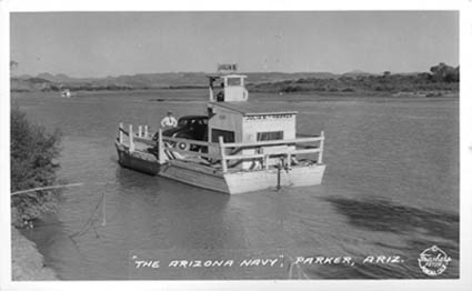
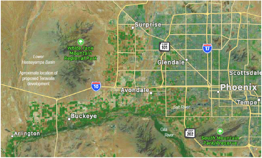

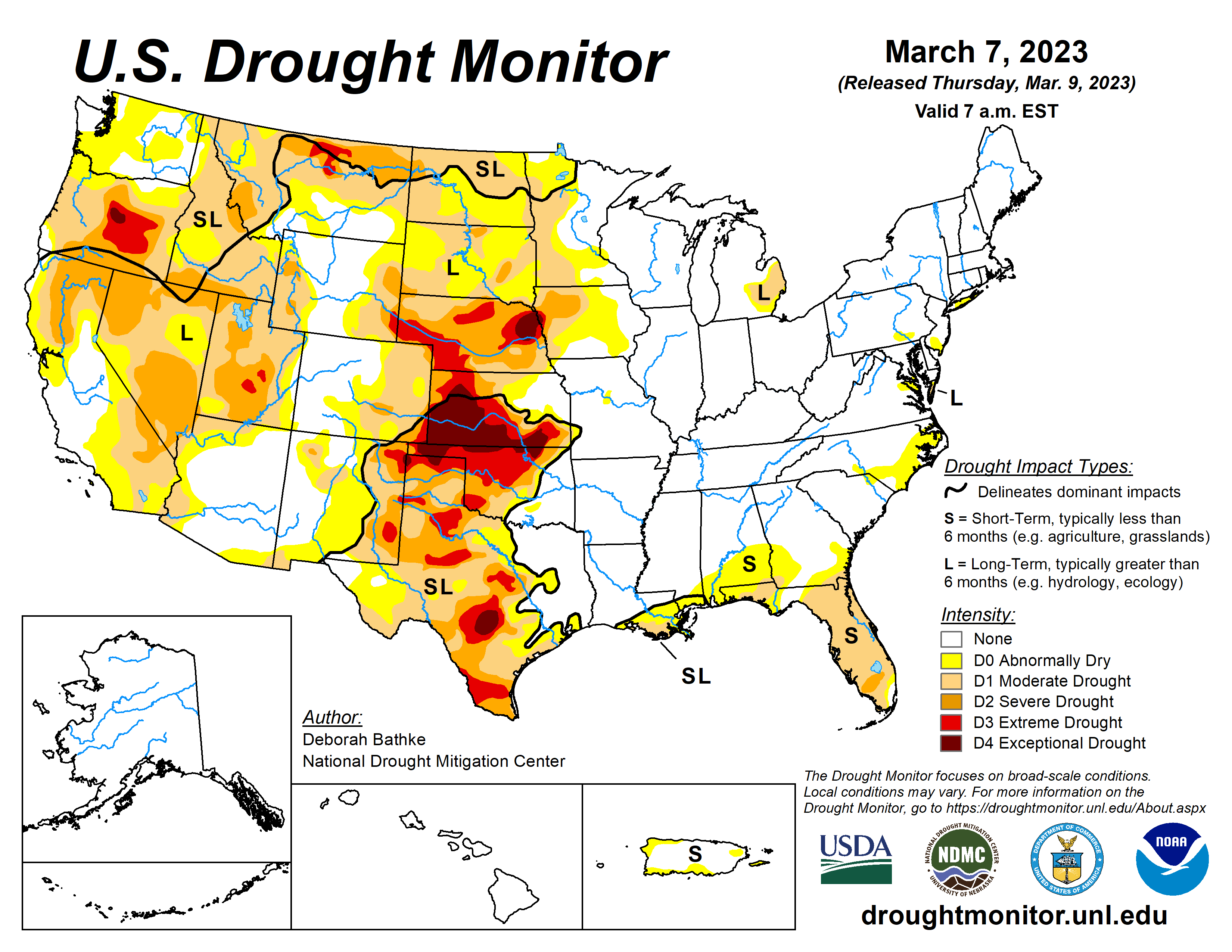
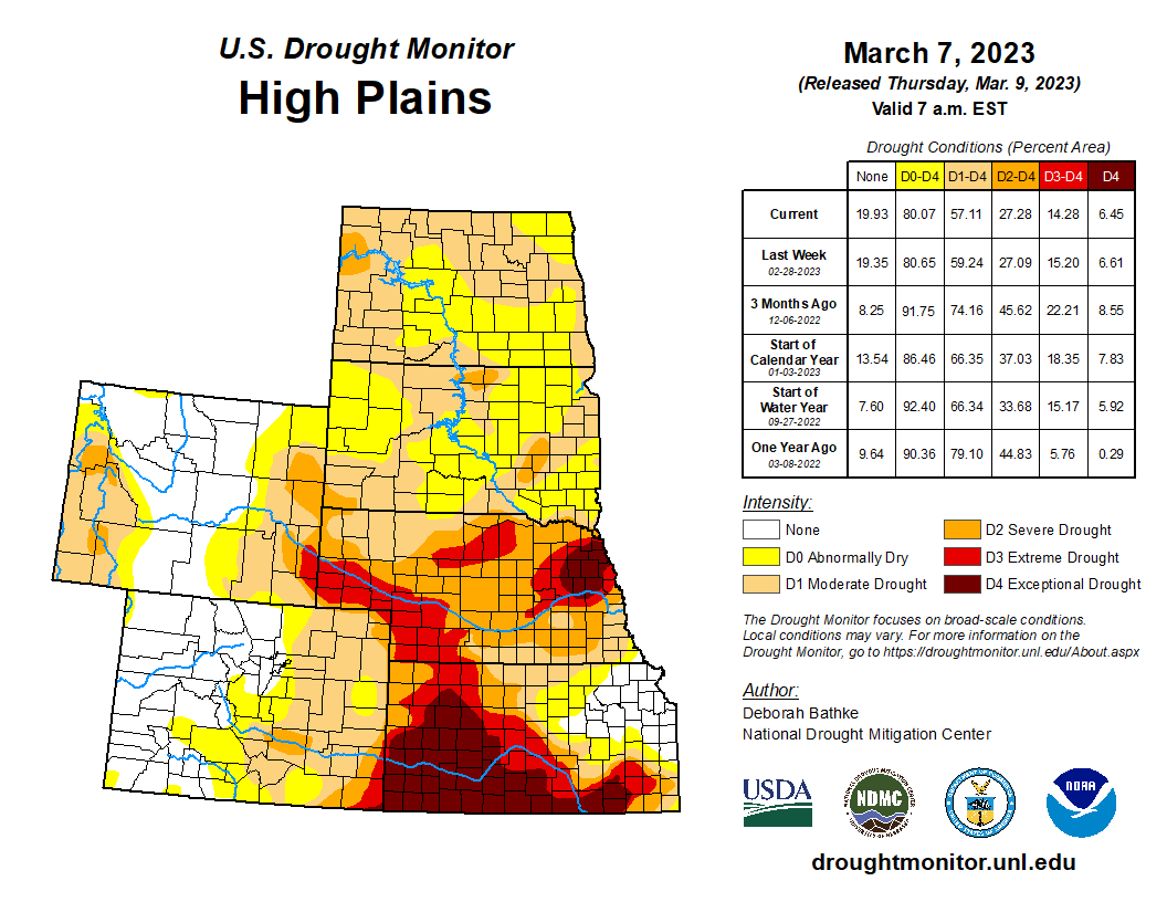

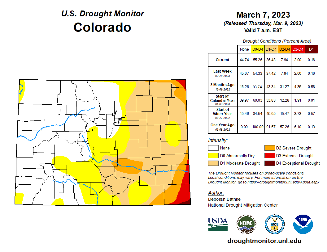

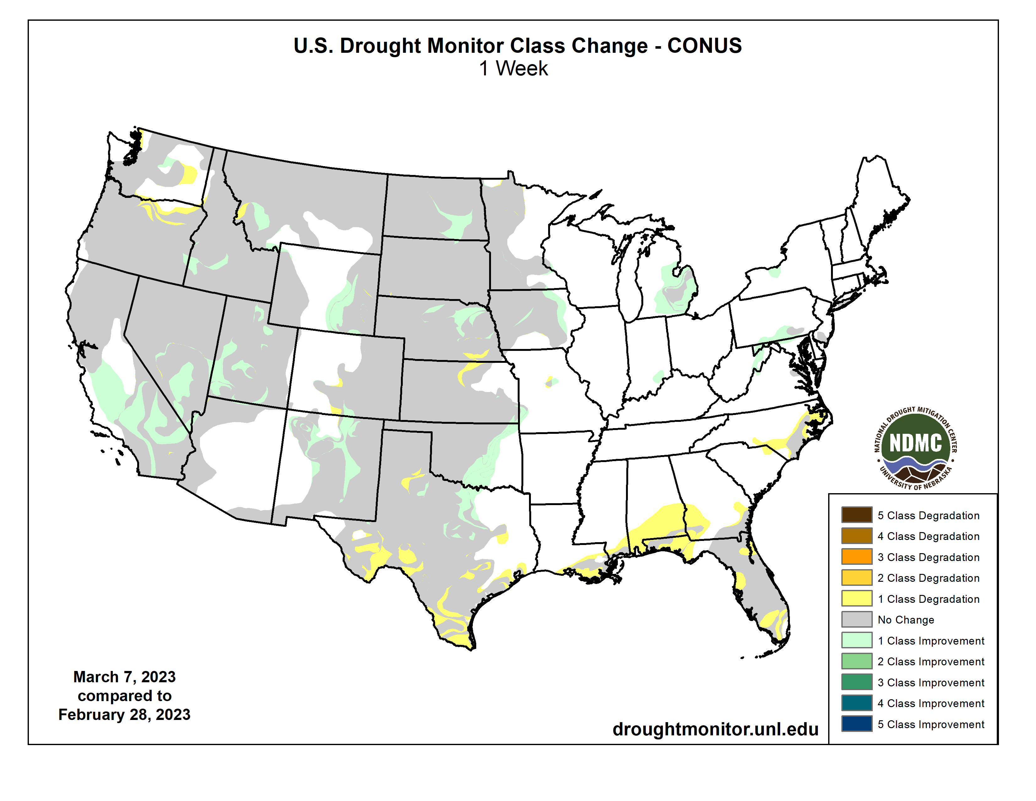


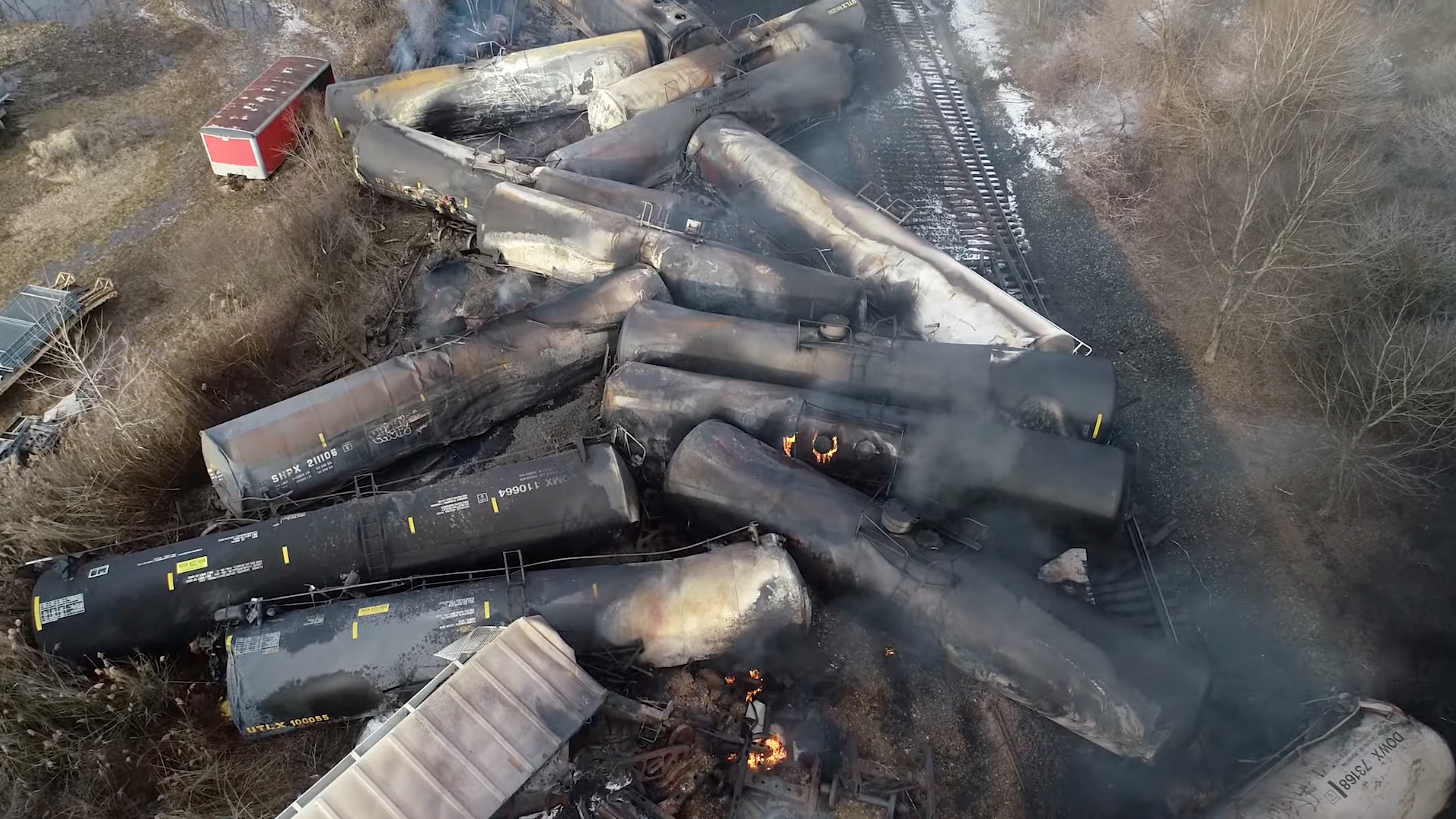
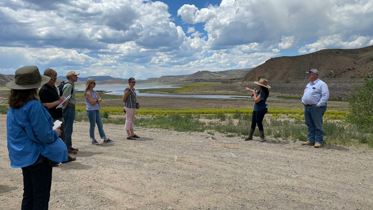
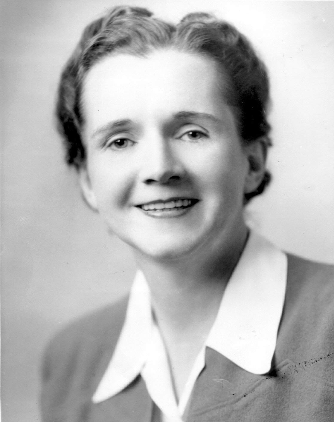


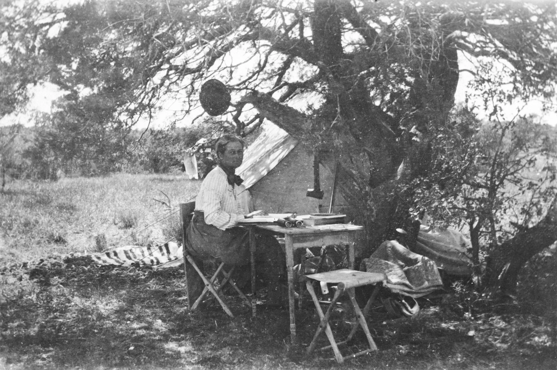

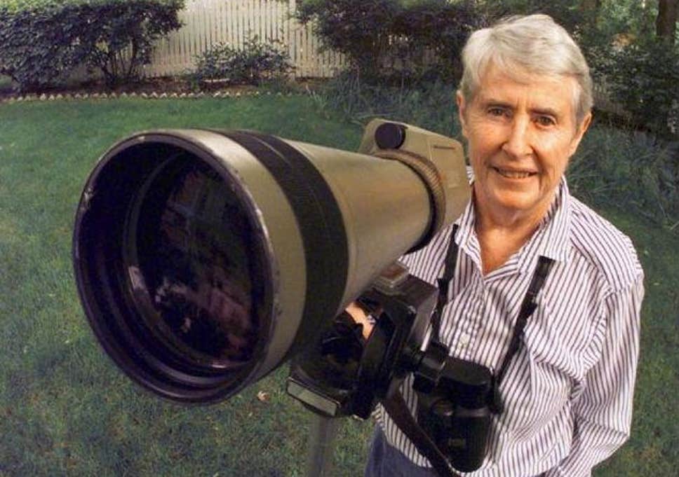
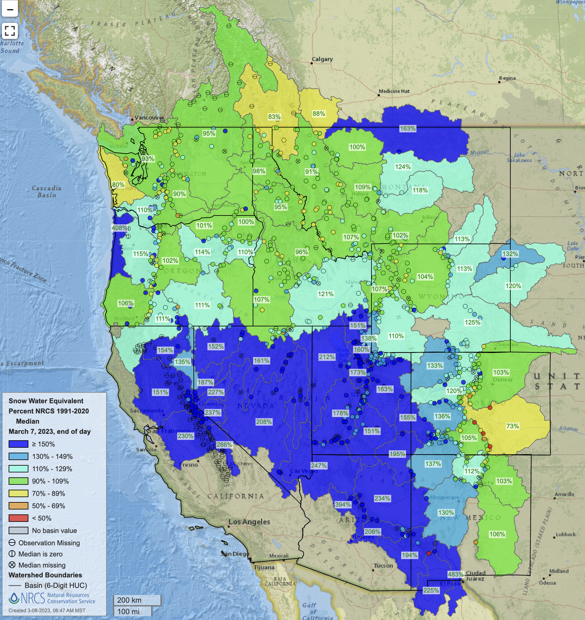


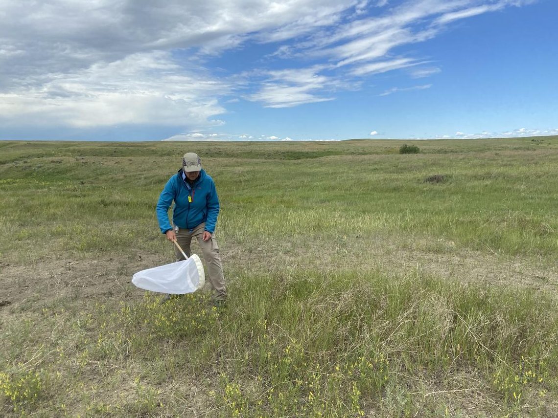
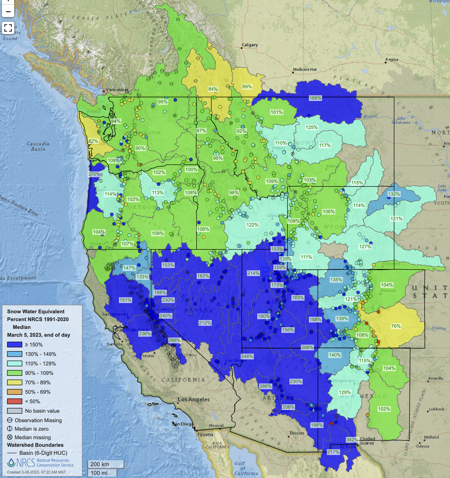
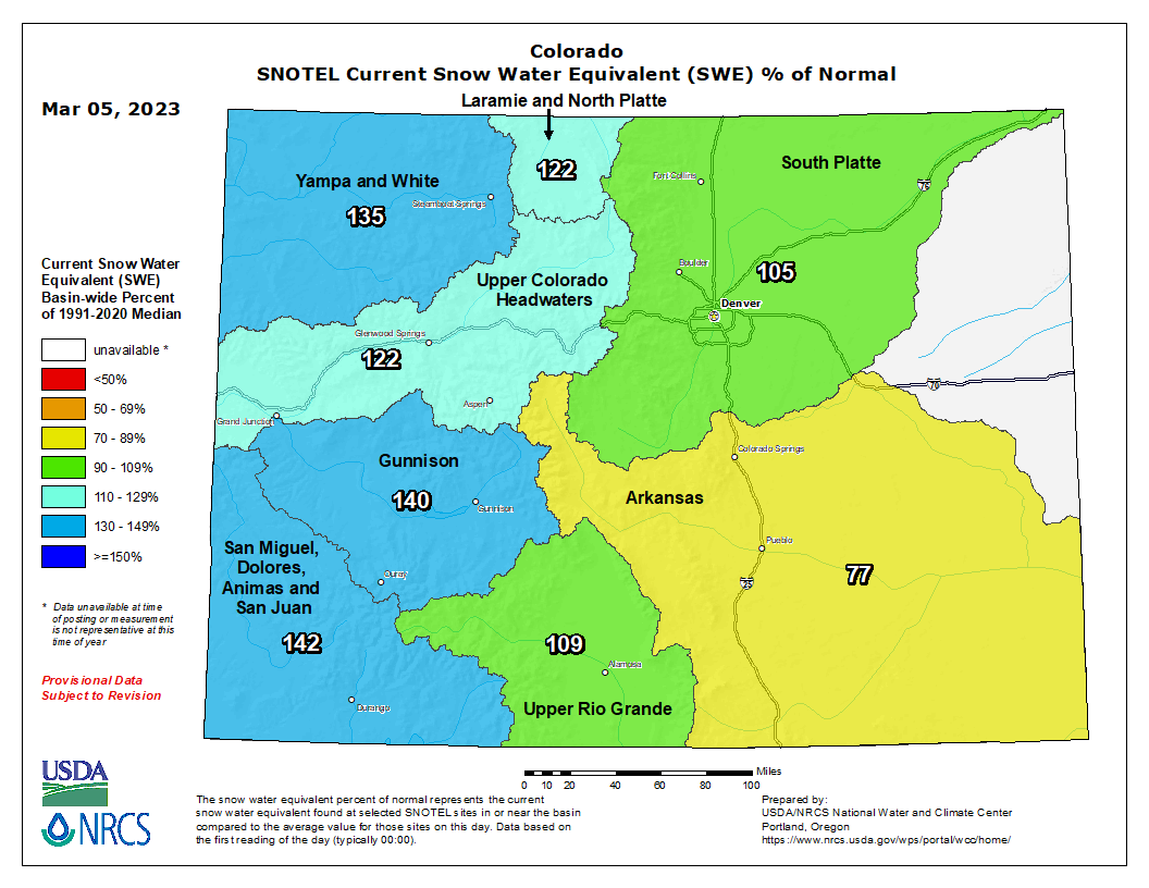
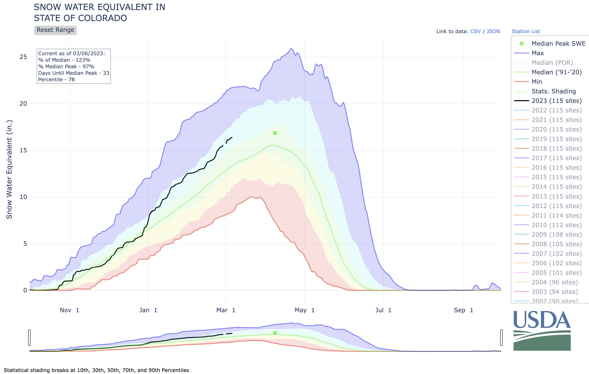
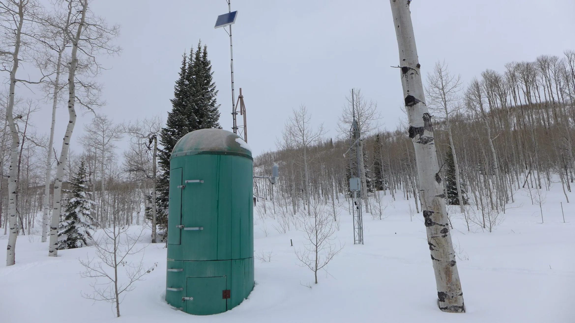

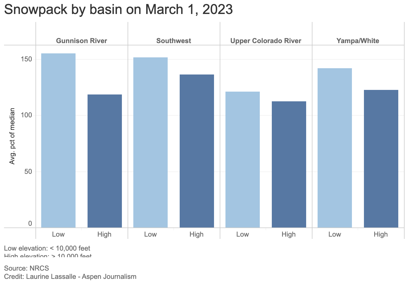
perhaps the best option to plump up the Colorado River’s giant reservoirs, Mead and Powell.