Arizona’s “Nexus of Vulnerability”

In a letter published by Environmental Research Letters, Andrew Berardy and Mikhail V. Chester of Arizona State University examined the agricultural and beef industry’s dependency upon water and power. Athough their research was focused the effects of climate change in Arizona, their findings could be applied almost anywhere in the American Southwest.

“Arizona’s predominately irrigated agriculture relies on water imported through an energy intensive process from water-stressed regions. Most irrigation in Arizona is electrically powered, so failures in either energy or water systems can cascade to the food system, creating a food-energy-water nexus of vulnerability.” Using data provided by the USDA, the U.S. Geological Survey, Arizona crop budgets and region-specific literature, the two scientists predicted that a temperature increase above the baseline could decrease yields by up to 12.2% per 1° centigrade for major Arizona crops and would require increased irrigation of about 2.6% per 1° centigrade.1

Modern agricultural production is made possible by systems working together to deliver energy and water resources necessary to provide a reliable food supply. This interdependency creates the food-energy-water nexus. Arizona is a major agricultural producer, supplying considerable animal feed, livestock, milled grain products, meat, and other food products to cities throughout the U.S.

U.S. map showing percentages of food-related imports from Arizona by state, categorized by color codes: animal feed, live animals/fish, milled grain products, other foodstuffs, and meat/seafood.
Figure 1. Importance of agricultural exports from Arizona. This map displays the food related goods shipped from Arizona as a percentage of total food related goods shipped to each state in the freight category where that percentage is highest based on 2012 Freight Analysis Framework data (Center for Transportation Analysis 2016). Cities with 5% or more of a category imported from Arizona are labeled with an icon representing the freight category and labeled with the percent of that category they receive from Arizona out of their total imports of that category. For example, Los Angeles receives 22% of their Live Animals and Fish imports from Arizona.

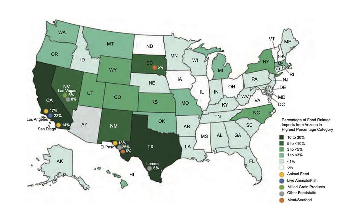
The Phoenix region’s large volume of food related exports means that reduced yields would have a signifcant impact on overall export capacity for Arizona. The most significant food related exports are to cities near Arizona – including Los Angeles, San Diego, El Paso, and Las Vegas. Tucson receives 100% of its live animals and fish, 85% of its other agricultural products, 83% of its other foodstuffs, and 69% of its meat and seafood from within Arizona. Phoenix receives 87% of its other agricultural products, 73% of its animal feed, 57% of its cereal grains, 51% of its other foodstuffs, and 51% of its live animals and fish from within Arizona. Therefore, disruptions to the agricultural system in the greater Phoenix area would have both a local impact, and would be felt across the Southwest in California, Nevada, and Texas.2

Shocks and strains on energy and water production and delivery systems may result in failures which cascade to food systems. In addition, feedback loops across the nexus could create compounding vulnerabilities, as failures in one system may propagate to another. Potential disruptions such as population growth, climate change, and interruptions to energy and water supply cause problems in food, energy, and water systems that combine and cascade to have downstream impacts on food supply and farm viability, which feed back into population growth in an iterative cycle.

Pie chart illustrating various factors affecting water availability, including shortage of surface water, ground water shortage, irrigation equipment failure, high water salinity, loss of water rights, cost of purchased water, energy price increases or energy shortage, and other factors.
Farms with diminished yields by cause. In 2013, Arizona farms reporting reduced yields attributed them primarily to water shortage and irrigation equipment failure, while the cost of water or energy shortage and price increases accounted for most of the remaining diminished yields (Vilsack and Reilly 2014). Arizona farms relied on irrigation for 100% of their total sales and 419 farms discontinued irrigation in 2013 (Vilsack and Reilly 2014).

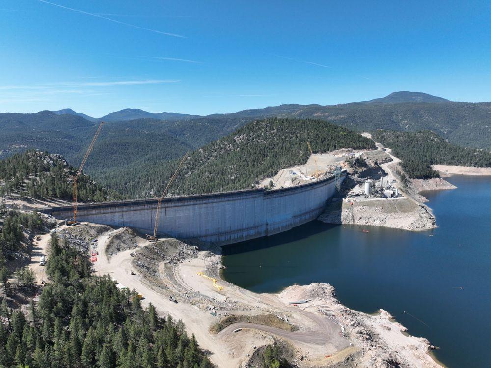
Climate change already has significant negative impacts on agriculture in the United States, causing substantial economic costs and raising serious questions about the vulnerability of food supply chain3. The Southwest is especially challenged due its rapidly increasing population, changing land use and land cover, limited water supplies, and long-term drought4. Arizona is largely a semi-arid desert receiving only 20.4 cm of rain across only 36 days per year on average and with an average yearly temperature of 24° centigrade. Despite a resulting reliance on imported water and sprawling housing developments reducing available arable land, Arizona has a strong agricultural history and significant specialty crop production.5 The strain of irrigation required for agriculture is manifested in crop losses for Arizona farmers, as reflected in figure 3, showing key drivers of yield loss as water shortage, water costs, energy costs, and equipment failure. In 2013 these problems affected about 15% of irrigated farmland in Arizona.

Failures in the Arizona food-energy-water nexus could cause disruptions throughout the Southwest as food supply chains for urban centers like El Paso, Los Angeles, and San Diego shift. There is also the potential for cascading impacts because these cities have their own exports which might be disrupted. As cities throughout the Southwest look to meet their own needs, there may be a significant change in food supply across the region. Regardless of potential systematic failures and reductions in crop yields, it is very likely that consumptive water use will increase as average temperature increases. Sustainable food supplies in Phoenix and Tucson, as well as other agriculturally productive regions of the Southwest, will require a greater amount of water drawn from sources that are already strained.

Please read the entire study, here

Historic intergovernmental agreement to protect the #CrystalRiver includes Pitkin County — The #Aspen Times

The Crystal River flows through the Gunnison County town of Marble, seen here with Beaver Lake. A representative from the Town of Marble is expected to participate in a subcommittee focused on an intergovernmental agreement to protect the river. CREDIT: ECOFLIGHT

May 27, 2026

Five Colorado governments, including Pitkin County, and water entities have officially entered into a landmark intergovernmental agreement to protect the Crystal River from mainstem dams and out-of-basin water diversions.

The official commitment of all five entities comes after Pitkin County gave its signature April 22.

The agreement comes at the recommendation of the Crystal River Wild and Scenic and Other Alternatives Steering Committee from March 2024, suggested as one of three potential long-term preservation measures, according to a press release. Along with Pitkin County, the Colorado River Water Conservation District, Gunnison County, town of Marble and West Divide Water Conservancy District formalized their shared commitment to oppose any new on-channel reservoirs on the mainstem of the Crystal River and any trans-basin diversions that would export water out of the watershed.

Push to the top at Gross Dam, in two parts: Major 2026 construction brings new challenges — Jay Adams (DenverWater.org) #FraserRiver #SouthBoulderCreek

Click the link to read the article on the Denver Water website (Jay Adams):

May 22, 2026

Each stage of a big construction project has its own challenges and puzzles to solve along the way. Raising Gross Dam is no different.

Denver Water is raising the height of the dam by 131 feet, with the final 22 feet going up this spring in two sections that are separated by a giant gap. The Gross Reservoir Expansion Project, which began construction in 2022, is designed to nearly triple the reservoir’s storage capacity. Major construction work resumed in April following a winter break.

And this year’s construction puzzles included:

  • How to move concrete across a 160-foot gap between where the concrete is made and where it’s placed?
  • And, how do you move construction vehicles across that same gap when work on the first section is finished?

“We are building the top of the dam in two sections because we need to leave a 160-foot gap in the middle of the dam for the spillway channel,” said Casey Dick, Denver Water’s deputy program manager for the Gross Reservoir Expansion Project.

Denver Water is building the last 22 feet of Gross Dam in two sections. The photo shows the left side at its new height. The right side’s last 22 feet will be finished in June. Photo credit: Denver Water.

Spillway channels are safety features on dams that allow water to safely flow out of a reservoir if needed due to flooding rains or exceptionally high and rapid snowmelt.

Raising the dam’s last two major sections, while leaving a 160-foot gap between them, meant coming up with a new way to move concrete across the construction site.

On the lower portion of the dam, crews worked on one continuous structure, which allowed trucks and equipment to easily move from one side of the dam to the other, and to move concrete from the batch plant down a large chute to where it was put into place.

However, with the final 22 feet going up in two sections, construction crews had to find a way to deliver concrete from the batch plant and across the 160-foot spillway gap as the first section went up.

The solution to this puzzle? A series of conveyors positioned in the middle of the dam that tilted higher as the first section rose higher.

“Building the new conveyor system is just another example of all the ingenuity we go through out here to build the dam,” Dick said. “With each new phase, there are new challenges that our team has to figure out.”

The new conveyor system moved concrete across the gap where the spillway channel will be to the far side of the dam. Photo credit: Denver Water.

Construction crews finished placing roller-compacted concrete on the dam’s left side on May 12.

But once that was done, crews faced the second challenge: How do you move the equipment off the finished, 22-foot higher section of the dam, across the spillway gap, down to where they are needed to complete the second section?

Short answer: If you can’t go over, go around.

Cranes lifted equipment off the higher section of the dam to the road, where the machines convoyed about 4.5 miles around to the other side using the dam’s access road.

A crane lifts a piece of equipment off the dam. Because of the new spillway gap, equipment was driven across the dam’s access road to get into position on the other side of the dam. Photo credit: Denver Water.

Construction on the final 22 feet of the second side of the dam began at the end of May and is expected to be completed in June.

Once the second section is done this summer, a year’s worth of remaining work includes: finishing the top of the dam, building safety walls; constructing the actual spillway; building a bridge over the spillway and completing the stilling basin at the bottom of the dam.

This view from the bottom of the dam shows the new baffle blocks on the bottom of the stilling basin. The baffle blocks reduce the energy of the water that flows down the spillway. Photo credit: Denver Water.

Full construction on the dam raising project is expected to wrap up in mid-2027.

“There are hundreds of logistical challenges throughout this project, but our team has been able to meet every one of them along the way,” Dick said. “We’re making good progress so far in 2026 and are looking forward to getting a lot of work done in the coming months.”

The Gross Reservoir Expansion Project involves raising the height of the existing dam by 131 feet. The dam will be built out and will have “steps” made of roller-compacted concrete to reach the new height. Image credit: Denver Water

#Clifton Water District implements drought rates — The #GrandJunction Daily Sentinel #ColoradoRiver #COriver #aridification

F Road (US Highway 6) in Clifton looking toward Grand Mesa. By Jeffrey Beall – Own work, CC BY 3.0, https://commons.wikimedia.org/w/index.php?curid=25479675

Click the link to read the article on the Grand Junction Daily Sentinel website. Here’s an excerpt:

May 27, 2026

The Clifton Water District announced Wednesday that it would join the list of utility providers implementing temporary drought rates, with a press release about the change calling for community members to take action with other drought mitigation efforts.

“The Clifton Water District urges all customers to take immediate steps to reduce water usage wherever possible,” the press release said. “Small changes — such as limiting outdoor watering, repairing leaks, and using water-efficient appliances — can collectively make a significant impact … By working together, Clifton residents can help ensure that safe and reliable water remains available for essential needs now and in the future.”

The change won’t alter billing for those using less than 3,000 gallons of water per month, much like similar rate restrictions recently announced by other providers. Clifton Water said it hoped to encourage prudent water usage with the higher rates. The district said the rates would remain in place “only until watershed conditions show meaningful improvement,” a stipulation that could mean Clifton Water customers are in for a long summer, with forecasts suggesting a historically dry year and winter snowpack widely observed at record-low levels.

Colorado River District launches emergency water plan to protect Western Slope communities during #drought — #Colorado Public Radio

Green Mountain Reservoir is owned by the U.S. Bureau of Reclamation and located in Summit County north of Silverthorne along the Blue River. Photo credit: Denver Water.

Click the link to read the article on the Colorado Public Radio website (Tegan Wendland). Here’s an excerpt:

May 22, 2026

The state and the Colorado River Water Conservation District, a public water policy and planning agency on the Western Slope, have a new plan to protect mountain towns from losing their water supply during an unprecedented drought this summer. The District’s proposed emergency water supply plan was approved at the Colorado Water Conservation Board meeting on Wednesday, May 20, 2026…The emergency plan would protect certain water users on the main stem of the Colorado River by replacing water that would have historically come from Green Mountain Reservoir. This year forecasts say it won’t fill up for the first time in history…A portion of the reservoir is reserved for what’s called the “historic users pool,” which holds 66,000 acre-feet of water…It’s an important emergency water supply plan that protects approximately 250 municipal and domestic water entities across the Colorado River Basin from being called out due to senior water rights claims. It was created as part of the Colorado Big Thompson project, a massive water engineering project that created reservoirs and redirected Colorado River water to Front Range cities…After a drought in 1977, water managers set aside the historic user pool for agricultural and domestic users. It’s historically always been filled and available to protect those water rights from being usurped by more senior users…Every year, a group of agricultural and utility entities in the Grand Valley near Grand Junction makes what’s called the “Cameo call” to use water from it. It’s the largest and most senior call on the main stem of the river and demands that they get enough water for their needs. That includes the Grand Valley Water Users Association, Grand Valley Irrigation Company, Orchard Mesa Irrigation District, Palisade Irrigation District, and Mesa County Irrigation District. The call is made annually, generally between June and August. This year, the fear is that if that water demand is called early, there won’t be enough water for upstream towns and municipalities, including Silverthorne, Eagle River, and Grand, Garfield and Mesa counties…

The River District plans to borrow water from other reservoirs — the nearby Wolford Mountain and Ruedi reservoirs — to replace the water that would have come from Green Mountain and to prevent the Cameo call from being made…At the meeting, the board committed to support the move with $585,000, in addition to $342,000 the District committed last month.

“Instead of having to turn off all of these cities’ water rights up here and the farms and ranches up above the Grand Valley, the Green Mountain historic user pool would release water to meet the Cameo call and protect the West Slope users. It is a really appropriate use of that water,” Mueller told CPR News.

Colorado-Big Thompson Project map. Courtesy of Northern Water.

#Colorado’s race to cut water use off to a slow start — Jerd Smith (Fresh Water News) #conservation

A sprinkler waters the gardens at Washington Park in Denver. July 12, 2019. Credit: Jerd Smith

Click the link to read the article on the Water Education Colorado website (Jerd Smith):

May 28, 2026

Denver Water customers have yet to embrace a strict water diet this year, cutting water use just 5% this month as the outdoor watering season begins.

The utility, which serves 1.5 million customers, has asked residents and businesses to slash water use by 20% this summer to combat extreme drought.

At the same time, reservoirs, unable to refill after melting snows evaporated early due to a surprising March heatwave, are dropping. The utility said its storage system is just 79% full, down from the 89% mark normally seen at this time of year.

Denver Water officials said they’re not disappointed with their customers, in part because they’re asking homeowners and businesses to adopt habits they haven’t had to use in years.

“We didn’t expect them to be saving 20% right away,” said Greg Fisher, Denver’s manager of water supply planning. “It’s been 13 years since we were under mandatory drought restrictions. It takes a few months to get up and running on this.”

Aurora homeowners and businesses have cut use 6.5%, Aurora Water spokesperson Shonnie Cline said. And the city’s reservoirs are similarly low, standing at just 56% full. This time last year they were 66% full.

At issue is Colorado’s drought emergency. Mountain snows, which provide the majority of the state’s water supplies, hit critical lows this year and then melted off in a March heat wave that also set records, with temperatures soaring into the 80-degree to 90-degree range.

In response, cities across the state imposed strict watering restrictions, pleading with customers to sharply limit water use so that water stored in reservoirs can be preserved as long as possible.

That reservoir levels are dropping in May is unprecedented, Fisher said. “Levels usually  would be rising now,” he said. “But ours are dropping.”

Rains this month have helped. The most recent forecasts indicate that summer monsoons may be wetter than normal and a developing El Niño weather pattern later this year could deliver more liquid relief, according to Russ Schumacher, director of Colorado State University’s Colorado Climate Center.

Rains won’t necessarily help refill reservoirs, but they will help reduce the summer demand for water, meaning less needs to be released from the giant storage pools.

Utilities hope their customers will use the rains that may come as a good reason to turn off their sprinklers.

“We need to use Mother Nature as much as we can,” Fisher said. “You can literally just take a week off.”

Colorado Springs is one of the few cities that hasn’t imposed special water restrictions because its reservoirs, at the start of the watering season, were fairly full. Its normal watering schedule limits sprinkler use to three days a week, according to Colorado Springs Utilities spokesperson Jennifer Johnson. The utility actually saw water use rise slightly in May. 

On Colorado’s Western Slope, the situation is also dire. This month the Colorado River District and the Colorado Water Conservation Board agreed to use water from special conservation pools in Ruedi and Wolford Mountain reservoirs to help small towns that are in danger of running out of water, and to provide some help to Western Slope farmers and the fish trying to survive in streams that are drying out.

Roughly half of the water that serves Denver and other Front Range communities comes from the Western Slope and the Colorado River. It is transferred through tunnels to the Front Range. Reductions in water use by Denver and other cities will take some of the stress off the Colorado River. 

Lindsay DeFrates, deputy communications director for the Colorado River District, said the district is asking Western Slope towns to water just one day a week.

The district manages the Colorado River and represents 15 Western Slope counties. It has no authority to impose restrictions on mountain communities, but it is still pushing hard for a broad-based commitment to turn off the sprinklers.

“And obviously,” DeFrates said, “we’re hoping Front Range cities will do the same.”

More by Jerd Smith