Workers begin raising the dam at Gross Reservoir — News on Tap

Click the link to read the article on the Denver Water website (Jay Adams):

June 6, 2024

Take an animated tour of the unique construction process.

Raising the height of a dam involves many steps, literally and figuratively. 

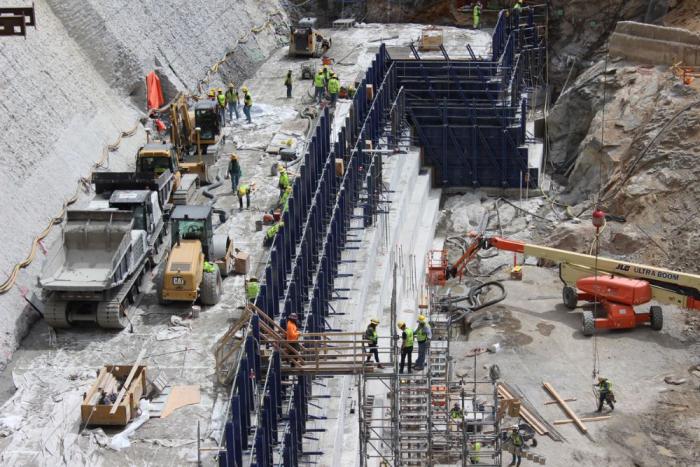
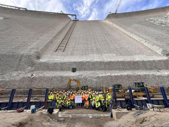
After two years of excavation and preparation work on the canyon around Gross Dam, workers in May began placing concrete, starting the three-year process of raising the height of the dam itself.

Denver Water is raising the height of Gross Dam by 131 feet as part of the Gross Reservoir Expansion Project. Once complete, the dam will be able to store nearly three times as much water in Gross Reservoir, which will add more resiliency and flexibility to Denver Water’s water storage system.

Workers from Denver Water and contractor Kiewit Barnard stand in front of Gross Dam in May to mark the start of the dam raise process. Photo credit: Denver Water.

Raising the dam is being done by building 118 steps made of roller-compacted concrete. Each step will be 4 feet wide with a 2-foot setback. The existing dam is 340 feet tall. The completed dam will be 471 feet tall. 

Check out this animated video to see how the process works.

This animation shows how Denver Water plans to raise the height of Gross Dam in Boulder County, Colorado, as part of the Gross Reservoir Expansion Project. #grossreservoir #civilengineering #howtoraiseadam

The construction site at the bottom of Gross Dam with equipment used to place concrete and build the new steps. Photo credit: Denver Water.

It will take roughly three years to complete all the steps, with a final completion date set for 2027.

The dam raise process begins at the bottom of the dam using roller-compacted concrete to build the new steps that will go up the face of the dam. Photo credit: Denver Water.

Planning and permitting for the Gross Reservoir Expansion Project began in 2002. Take a look at this video to learn about the process and major accomplishments.

Denver Water is raising the height of Gross Dam in Boulder County, Colorado as part of the Gross Reservoir Expansion Project. This video looks at the history of the project and the work being done to raise the dam.

Hurricane Beryl’s rapid intensification and Category 5 winds are alarming: Here’s why more tropical storms are exploding in strength

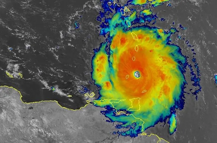
Hurricane Beryl hit the island of Carriacou, Grenada, on July 1, 2024, with 150 mph sustained winds. NOAA

Brian Tang, University at Albany, State University of New York

Hurricane Beryl was the latest Atlantic storm to rapidly intensify, growing quickly from a tropical storm into the strongest June hurricane on record in the Atlantic. It hit the Grenadine Islands with 150 mph winds and a destructive storm surge on July 1, 2024, then continued to intensify into the basin’s earliest Category 5 storm on record.

The damage Beryl caused, particularly on Carriacou and Petite Martinique, was extensive, Grenada Prime Minister Dickon Mitchell told a news briefing. “In half an hour, Carriacou was flattened.”

Beryl’s strength and rapid intensification were unusual for a storm so early in the season. This year, that is especially alarming as forecasters expect an exceptionally active Atlantic hurricane season.

Rapidly intensifying storms can put coastal communities in great danger and leave lasting scars. In 2022, for example, Hurricane Ian devastated portions of Florida after it rapidly intensified. To this day, residents are still recovering from the effects. As Beryl continued across the Caribbean Sea on July 2, Jamaica and the Cayman Islands were under hurricane warnings.

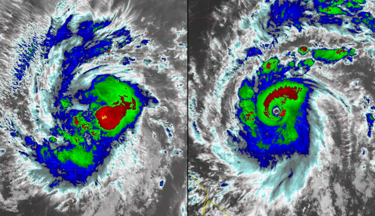
Two satellite images show how the storm became more organized around the eye over a short period of time.
Two satellite images of Beryl taken on June 29, left, and June 30: As Beryl rapidly intensified, an eye formed, and deep thunderstorms wrapped around it. Cooperative Institute for Research in the Atmosphere

What causes hurricanes to rapidly intensify, and has climate change made rapid intensification more likely?

I research hurricanes, including how they form and what causes them to intensify, and am part of an initiative sponsored by the U.S. Office of Naval Research to better understand rapid intensification. I also work with scientists at the National Atmospheric and Oceanic Administration to analyze data collected by reconnaissance aircraft that fly into hurricanes. Here’s what we’re learning.

How did Hurricane Beryl intensify so quickly?

Rapid intensification occurs when a hurricane’s intensity increases by at least 35 mph over a 24-hour period. Beryl far exceeded that threshold, jumping from tropical storm strength, at 70 mph, to major hurricane strength, at 130 mph, in 24 hours.

A key ingredient for rapid intensification is warm water. The ocean temperature must be greater than 80 degrees Fahrenheit (27 Celsius) extending more than 150 feet below the surface. This reservoir of warm water provides the energy necessary to turbocharge a hurricane.

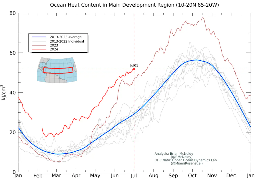
Scientists measure this reservoir of energy as ocean heat content. The ocean heat content leading up to Beryl was already extraordinarily high compared with past years. Normally, ocean heat content in the tropical Atlantic doesn’t reach such high levels until early September, which is when hurricane season typically peaks in activity.

A chart shows ocean heat content over the main development region for hurricanes in the Atlantic much higher in 2024 than any year of the past decade.
Ocean heat content of the Atlantic Ocean region where a large proportion of hurricanes form. The bold red line is 2024’s ocean heat content, and the blue line is the 2013-2023 average. Brian McNoldy/University of Miami

Beryl is a storm more typical of the heart of hurricane season than of June, and its rapid intensification and strength have likely been driven by these unusually warm waters.

In addition to the high ocean heat content, research has shown other environmental factors need to typically align for rapid intensification to occur. These include:

My research has shown that when this combination of factors is present, a hurricane can more efficiently take advantage of the energy it gathers from the ocean to power its winds, versus having to fight off drier, cooler air being injected from around the storm. The process is called ventilation.

Simultaneously, there is an increase in air being drawn inward toward the center, which quickly increases the strength of the vortex, similar to how a figure skater pulls their arms inward to gain spin. Rapid intensification is akin to a figure skater pulling in both their arms quickly and close to their body.

Has climate change affected the likelihood of rapid intensification?

As oceans warm and ocean heat content gets higher with climate change, it is reasonable to hypothesize that rapid intensification might be becoming more common. Evidence does suggest that rapid intensification of storms has become more common in the Atlantic.

Additionally, the peak intensification rates of hurricanes have increased by an average of 25% to 30% when comparing hurricane data between 1971–1990 and 2001–2020. That has resulted in more rapid intensification events like Beryl.

This increase in rapid intensification is due to those environmental factors – warm waters, low vertical wind shear and a moist atmosphere – aligning more frequently and giving hurricanes more opportunity to rapidly intensify.

A chart shows an increase in rapidly intensifying hurricanes over 36 years.
Two long-term datasets show an upward trend in the proportion of Atlantic hurricanes that rapidly intensified from 1982 to 2017. Bhatia et al. (2022)

The good news for anyone living in a region prone to hurricanes is that hurricane prediction models are getting better at forecasting rapid intensification in advance, so they can give residents and emergency managers more of a heads-up on potential threats. NOAA’s newest hurricane model, the Hurricane Analysis and Forecast System, shows promise to further improve hurricane forecasts, and artificial intelligence could provide more tools to predict rapid intensification.

This article has been updated with Cayman Islands hurricane watch upgraded to a hurricane warning.

Brian Tang, Associate Professor of Atmospheric Science, University at Albany, State University of New York

This article is republished from The Conversation under a Creative Commons license. Read the original article.

Coyote Gulch’s excellent EV adventure: Baseball!

Coyote Gulch’s Leaf charging at a -chargepoint+ facility in Oakley, Kansas July 2, 2024.

I took a few days off to drive to Kansas City, Missouri for a baseball game between the Kansas City Quitters and the St. Louis Skeletons. The Skeletons are a new team having formed from an extended circle of friends in St. Louis, just over a year ago, and they emerged from the game victorious over the home team. The Quitters fell behind early but staged a furious comeback in the late innings and came up one run short at the end. I love the diverse player rosters which included women in key positions.

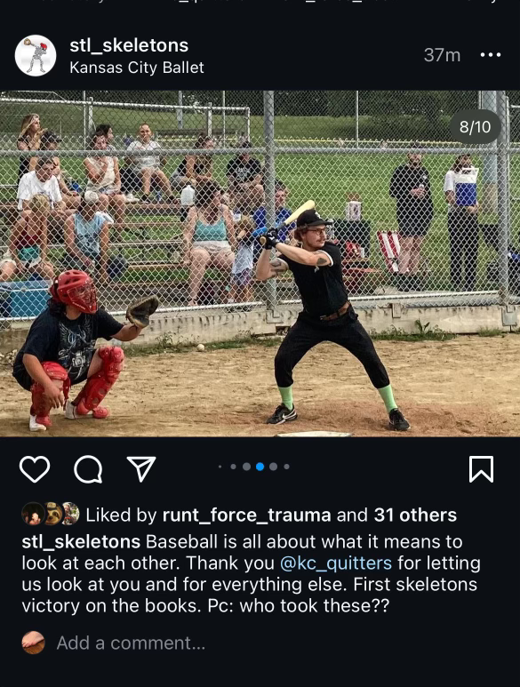
“Skeleben” trying to keep the Skeletons ahead during the late innings June 29, 2024. Coyote Gulch is in the photo upper left white t-shirt.

At least for this game the league has an innovative format. The game was paused after the 4th inning for a Punk Rock concert with two local bands. The players got the chance to relax with some dancing and some time to hydrate (It is hot in Kansas City in June). I don’t often listen to Punk Rock but I have great respect for the musicians that played on Saturday. How many times is the venue a baseball diamond facing home plate? Probably not many.

4th inning Punk Rock concert during the baseball game between the Kansas City Quitters and the St. Louis Skeletons June 29, 2024 at Penn Valley Park in Kansas City, Missouri.

I don’t like to take my Leaf on these long drives. It has an old charging technology and it takes planning to find chargers with CHAdeMO connectors. This trip was necessitated by Hertz cancelling my Tesla rental the day before I was to leave — they said a hail storm had left them short of Teslas to fulfill my contract.

I charge fairly often so that I don’t have to spend too much time at each stop and so I can chew up charge at highway speeds without concern.

Charging was a breeze however as -chargepoint+ chargers were available in Limon, Burlington, Oakley, and Topeka and -chargepoint+ has CCS and CHAdeMO connectors on all of their chargers that I’ve used. There is a sort of CHAdeMO desert in Kansas but in Hays the Walmart has an Electrify America facility with one CHAdeMO connector and in Salina I’ve charged at Casey’s General Store near I-70. That charger was out of service however both ways on this trip but I was able to charge at Marshall Motor Company (a Nissan dealership) in Salina. It is very fast but only available during business hours. After Salina I charged in downtown Topeka (I unplugged an F-150 Lightning that had a full charge since there is only one -chargepoint+ charger there) then proceeded to my hotel in Kansas City.

Charging for the way home was at Wyandotte Plaza in Kansas City, Kansas on a very fast EVGO charger, then Topeka, Salina, Hays, Oakley, Burlington, and Limon.

If you are looking to buy an EV I don’t recommend the Leaf if you plan to go on long drives, charging just adds too much time. I don’t have any experience with the newer EVs with CCS connectors but they potentially charge very quickly if the KW potential at charging infrastructure is a fair indicator.

The Tesla charging network is fantastic and is integrated with their vehicle navigation system so that is my EV of choice for long trips. The navigation system takes you to the Tesla Superchargers and they are all about getting you in, charged, and out. Hopefully Hertz will get their supply in order before I need to rent the next one.

What’s next after Supreme Court curbs regulatory power: More focus on laws’ wording, less on their goals — The Conversation

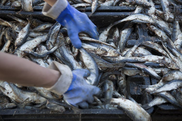
Two fishing companies challenged regulations that required Atlantic herring fishers to pay some costs for observers on their boats. Joe Raedle/Getty Images

Robin Kundis Craig, University of Kansas

Federal Chevron deference is dead. On June 28, 2024, in a 6-3 vote, the Supreme Court overturned the 40-year-old legal tenet that when a federal statute is silent or ambiguous about a particular regulatory issue, courts should defer to the implementing agency’s reasonable interpretation of the law.

The reversal came in a ruling on two fishery regulation cases, Loper Bright Enterprises v. Raimondo and Relentless, Inc. v. Department of Commerce.

This decision means that federal courts will have the final say on what an ambiguous federal statute means. What’s not clear is whether most courts will still listen to expert federal agencies in determining which interpretations make the most sense.

While courts and judges will vary, as a scholar in environmental law, I expect that the demise of Chevron deference will make it easier for federal judges to focus on the exact meaning of Congress’ individual words, rather than on Congress’ goals or the real-life workability of federal laws.

Who decides what the law means?

Chevron deference emerged from a 1984 case that addressed the Environmental Protection Agency’s interpretation of the term “stationary source” in the Clean Air Act. The EPA asserted that a “source” could be a facility that contained many individual sources of air pollutant emissions. This meant, for example, that a factory with several smokestacks could be treated as a single source for regulatory purposes, as if it were enclosed in an imaginary bubble.

In upholding the EPA’s decision, the Supreme Court created a two-step test for deciding whether to defer to a federal agency’s interpretation of a statute that it administers.

In Step 1, the court asks whether Congress directly addressed the issue in the statute. If so, then both the court and the agency have to do what Congress directs.

In Step 2, however, if Congress is silent or unclear, then the court should defer to the agency’s interpretation if it is reasonable because agency staff is presumed to be experts on the issue. Justice John Paul Stevens reportedly told his colleagues, “When I am so confused, I go with the agency.”

The central question in both the Loper Bright and Relentless cases was whether the U.S. secretary of commerce could require commercial fishers to pay for onboard observers they were required to bring on some fishing voyages to collect catch data. Lower courts in these cases deferred to the agency’s interpretation that, under the Magnuson-Stevens Fishery Conservation and Management Act, it could require fishers to pay.

However, in an opinion by Chief Justice John Roberts, the Supreme Court majority concluded that Chevron deference contradicts the Administrative Procedure Act. This broad law governs both the procedures that federal agencies must follow and, more importantly, the standards that federal courts must use to review agency actions.

As the majority pointed out, under the Administrative Procedure Act, “courts must ‘decide all relevant questions of law’” – explicitly including interpreting statutes.

Curbing the administrative state

Since 1984, Chevron deference has become pervasive in federal administrative law. By the Supreme Court’s count, 70 of its own decisions in that time have turned on Chevron deference.

More importantly, thousands of lower federal court decisions – more than 400 a year on average – have deployed Chevron deference on issues ranging from Social Security benefits to workplace safety standards, immigration eligibility and environmental protection requirements.

Chevron deference gave many federal agencies broad flexibility to use laws to address new and emerging problems that Congress did not anticipate. But some members of the current Supreme Court – as well as some federal appellate judges – criticized this doctrine, for two key reasons.

First, it authorized executive branch agencies to interpret federal law and forced courts to accept agencies’ reasonable interpretations. However, since the Supreme Court’s 1803 decision in Marbury v. Madison, it has been the duty of courts – not federal agencies – to say what the law is.

Second, Chevron deference arguably allowed federal agencies to grab more regulatory authority than Congress intended them to have, usurping the legislative branch’s responsibility to make law and delegate authority.

EPA infographic outlining the regulatory process.
Regulatory agencies take general directions written in laws from Congress and develop specific policies to achieve the goals Congress defined. EPA

How much does Loper Bright undo?

The court majority emphasized that prior court decisions upholding agency interpretations based on Chevron deference cannot be challenged solely because of that fact. As Roberts wrote, these holdings “are still subject to statutory stare decisis.”

Stare decisis, or “the thing is decided,” is legalese for why courts will respect prior decisions. In other words, no challenger can go back to a court that relied on Chevron deference and ask the court to change its original decision that the agency’s interpretation was OK.

That’s good so far as it goes. However, many agency interpretations of statutes can be challenged multiple times.

For example, the Clean Water Act protects “waters of the United States.” In 2023, the Biden administration issued new regulations interpreting which bodies of water the law covers. Challengers who disagree with that interpretation can attack the regulations directly and argue that the agencies’ reading of the law is wrong, as the fishing companies did in the Loper Bright cases.

However, under many laws, businesses and individuals can also challenge an agency interpretation at the moment when the agency decides that a general regulation applies specifically to them. These are called “as applied” challenges. After Loper Bright, any time an agency that benefited from Chevron deference goes to apply its interpretation to a new regulated entity, that regulated entity can challenge the agency interpretation – and this time the agency won’t get Chevron deference.

Will federal courts still listen to regulators?

Eliminating Chevron deference will likely worsen an existing division among judges, and justices, about how to go about interpreting statutes. It centers on how much a statute’s purpose and context should matter – or, instead, how much the judge should focus on the “plain meaning” of the particular words that Congress chose to use.

Suppose, for example, that a federal court faced the issue of how to define a vegetable for purposes of determining whether import taxes apply to imported tomato sauce. A plain meaning approach would emphasize that Congress decided to tax vegetables and that tomatoes are fruits; hence, tomato sauce is not subject to the import tax.

An approach focused on Congress’ purpose, in contrast, would emphasize that Congress wanted to tax all imports of savory foods that the public generally considers to be vegetables. Using this approach, the Supreme Court in 1893, in fact, decided that tomatoes were vegetables subject to import taxes.

Federal agencies typically take Congress’ purpose and the context in which regulators act very much into account when they decide what laws mean. For example, when the Food and Drug Administration had to distinguish proteins, which qualify as biologics for regulatory purposes, from chains of amino acids, which qualify as drugs, it focused on Congress’ reasons for creating the two categories. Ultimately, the agency decided that a molecule made up of amino acids had to have a certain level of complexity to qualify as a protein, and hence a biologic.

In contrast, ever since the late Justice Antonin Scalia joined the Supreme Court in 1986, federal judges – and especially Supreme Court justices – have taken an increasingly “plain meaning,” or textualist approach, to statutory interpretation. The current Supreme Court, for example, would almost certainly never have allowed a tomato to be a vegetable.

Dissenting Justices Elena Kagan, Sonia Sotomayor and Ketanji Brown-Jackson, along with many other legal experts, foresee serious problems for future cases that turn on highly technical issues. What will happen when a statute’s nonexpert plain meaning makes no practical sense in a highly technical or scientifically nuanced regulatory regime, such as the FDA classifying biologics and drugs?

Gorsuch, seated, gestures during testimony.
Supreme Court Justice Neil Gorsuch, shown during his confirmation hearing on March 22, 2017, argued in 2022 that Chevron deference ‘deserves a tombstone no one can miss.’ AP Photo/Susan Walsh

How long will the APA matter?

This ruling also may signal that the court plans to pay greater attention to the 1946 Administrative Procedure Act’s primacy in federal administrative law. This statute had been in place for almost 40 years when the Supreme Court decided Chevron in 1984, and the Chevron majority did not see it as a problem at the time.

Now, however, it has become a reason to overturn Chevron deference. Other court-created glosses on administrative law may also be dead doctrines walking.

Congress can and has created different standards of review in other statutes, including the Clean Air Act that led to the Chevron decision. What if a future Congress specifically directs that the implementing agency should take the lead in interpreting a particular statute?

I expect that the Supreme Court would reach for the Constitution and declare any such delegation unconstitutional. In other words, it is probably only a matter of time before Loper Bright’s overruling of Chevron deference becomes a matter of federal constitutional law.

This is an updated version of an article originally published January 17, 2024.

Robin Kundis Craig, Professor of Law, University of Kansas

This article is republished from The Conversation under a Creative Commons license. Read the original article.

Farmers in El Paso area cope with hotter weather, drier days

by Priscilla Totiyapungprasert, El Paso Matters
June 27, 2024

CLINT, Texas – When pecan farmer Guadalupe Ramirez glanced up at the overcast skies last Friday morning, he felt a sense of relief. The drizzle that came wasn’t much, he said, not like the burst of rainfall parts of El Paso received earlier that week. But still, he welcomed the light sprinkle of rain and cooler temperatures – a break, finally, from the relentless stretch of dry, 100-plus degree weather.

“The skies were gray, but not gray in sadness,” Ramirez said. “I thought ‘Oh, this is nice. It’s going to be a nice day.’”

Ramirez was flood irrigating his trees at Ramirez Pecan Farm that morning. The family-run farm, located in the small town of Clint east of the El Paso city limits, has 300 trees whose fruit are small and green in the summer. As the pecans ripen, the husks will turn brown and crack open, ready for harvest in late fall and winter.

But if the trees don’t get enough water, the pecans drop too early. Last summer’s brutal, record-breaking heat could even affect the quality of this year’s pecans if the orchard doesn’t experience a decent monsoon season, Ramirez said.

El Paso is already on track to have a summer that’s hotter than historical average. Last year, the U.S. Department of Agriculture updated its plant hardiness zone map based on decades of temperature data. El Paso shifted half a zone up because of warmer winters.

New pecans, tiny and green, appear in the foliage of trees at Ramirez Pecan Farm, June 21, 2024. Co-owner Lupe Ramirez says that o save resources, a tree stressed by heat and drought may drop its pecans early, leaving him with a far-reduced crop. (Corrie Boudreaux/El Paso Matters)

As climate change and human activities cause higher temperatures, longer heat waves and lower water levels, local farmers have no choice but to adapt if they want to keep their crops alive.

Longer stretches of hotter days “not a one-time deal”

About 9 miles north of Ramirez Pecan Farm, the Loya family also received a sprinkle – not the amount of rain they wanted. Ralph and Marty Loya manage Growing with Sara Farms in Socorro, selling fruit and vegetables from their farm store Bodega Loya, as well as through Desert Spoon Food Hub in El Paso.

Their farm has lost a couple rows of squash already. Workers will have to replant the lost crops, which requires more seed and compost, Marty said.

This June, workers had to harvest crops more quickly because the food can’t sit out in the sun, Marty said. Some food will dry out. Other foods, such as okra, grow bigger and harder. Timing is more critical than ever.

Ralph Loya finds ripe tomato on the vine at Growing With Sara farm, where he employs growing practices he learned from his father and grandfather. (Corrie Boudreaux/El Paso Matters)

It’s not just the timing of harvest. The timing of planting has also affected some crops, said Raymond Flores, farm assistant at La Semilla Food Center in Anthony, New Mexico, just west of El Paso.

Last year the first crop of corn planted in early spring didn’t do well, he said. The area experienced a streak of more than five consecutive weeks of triple-digit temperatures in June and July. Prolonged heat stress sterilized the pollen and affected the flowers, which couldn’t produce much corn.

The second planting around the end of May fared better, Flores said. The extreme heat wave had begun to subside by the time the corn stalks began flowering.

Tomato fertility is also particularly sensitive to the heat, he added. Last year’s tomato harvest came later than usual because the plants couldn’t produce until it cooled down. Workers use shade covers for the tomatoes.

Farmers in general are resilient and have already made changes because of the ongoing drought,” said Tony Marmolejo, operations development manager at Desert Spoon Food Hub. But the duration of last year’s high temperatures caught people off guard.

“When we got hit with the heat wave last year, everyone knew it wasn’t a one-time deal,” Marmolejo said. “Local farmers started making adjustments before this one came about.”

A basket of locally-grown carrots at Desert Spoon Food Hub on May 31, 2023. (Corrie Boudreaux/El Paso Matters)

Marmolejo coordinates with suppliers, mostly organic farms in El Paso and New Mexico, to place orders based on what they have available.

Desert Spoon Food Hub would usually get baby carrots around this time from a farm in Vado, New Mexico. But the carrots came earlier in the year and for a shorter time, Marmolejo said. So far, he’s seen less tomatoes and asparagus coming in. The squash and peaches aren’t coming in as early either.

“Not everybody got rain,” Marmolejo said of the recent break in weather patterns. “They have to use more water because there’s less moisture in the air, less moisture in the soil. But there’s less water supply, so it’s a no-win situation here.”

The El Paso area normally receives an inch of rain from May through June, but has only received 0.07 inches in the past two months, according to National Weather Service data.

Dwindling water supply also a concern

While most of the Ramirez farm is dedicated to pecan trees, it also grows alfalfa for livestock. But Ramirez said they stopped planting alfalfa in the last couple years because they need to save all the water for the pecan trees.

A grackle flies through an irrigated orchard at Ramirez Pecan Farm, June 21, 2024. The water that floods the orchards attracts animals in the summer heat. (Corrie Boudreaux/El Paso Matters)

To plan ahead, workers trim down the trees in the winter so, come summer, there’s less branches to hydrate. It’s a balancing act of quantity and quality. When water is limited, Ramirez has to be efficient if he wants his trees to produce quality pecans.

Ramirez waters his trees through flood irrigation every two to three weeks. 

Letting the soil get too dry and start cracking will stress the roots and make it difficult to retain moisture, he said. Older trees have deeper roots that can tap into the underground water basin, but if it’s a dry year, the water basin level also goes down.

If he receives less water from his allotment, he reduces irrigation to just enough to keep the trees alive, but that’s not enough to have the healthiest trees, he said.

His water allotment fluctuates depending on water levels at Elephant Butte reservoir in New Mexico. The reservoir feeds the Rio Grande canal system from which he and other El Paso farmers draw their water.

Lupe Ramirez, co-owner and manager of Ramirez Pecan Farm, shows the size difference between what he says is an average-sized pecan leaf and a leaf whose growth is stunted by heat and drought, June 21, 2024. (Corrie Boudreaux/El Paso Matters)

Rain helps in ways beyond water conservation. Rainwater has a different profile of nutrients, which includes nitrates, a form of nitrogen, Ramirez explained. The rain also knocks down pests such as aphids from the leaves, he added.

“Maybe it’s wishful thinking,” Ramirez said. “I’m hoping for a good wet season, but climate is changing.”

Monsoon, when the region normally receives the majority of its rainfall, runs from June 15 to Sept. 30. Last year, El Paso received 4 inches of rain, below its historic annual average of 9 inches.

Farmers plan for the future

Ralph Loya has had to water his crops more than usual this past month, using flood irrigation with canal water for the fruit trees and drip irrigation with municipal water for the vegetables. Like Ramirez, he also depends on his allotment from the Rio Grande – a river that’s been a source of irrigation for centuries, but has been choked by increasing development.

His wife, Marty, said they’re considering putting more shade structures on their produce fields as well as a new cover on their greenhouse next year. The shade creates cooler temperatures, which help the soil retain moisture.

Ramirez said he has a shallow well and has thought about installing a deeper well. But wells come with a hefty price tag and don’t address tightening water restrictions, he said.

Lupe Ramirez, co-owner and manager of Ramirez Pecan Farm, poses for a portrait in front of his farm store, where he sells homemade pecan candies and baked goods and raw, unshelled pecans, June 21, 2024. (Corrie Boudreaux/El Paso Matters)

If drought and extreme heat waves continue, small farms with less capital and access to resources could get pushed out of the industry, Flores said.

“The best time to take action against climate change is as soon as possible, but there’s only so much we can do,” Flores said. “It’s a giant system. It’s going to take the collective effort of everyone to change.”

This article first appeared on El Paso Matters and is republished here under a Creative Commons license.

Opinion: Hoping for a miracle to save the #OgallalaAquifer? Prepare for the new Dust Bowl — The #KansasReflector

In this archive photo, an ATV races along the dry bed of the Arkansas River at Dodge City, Kansas. Because of irrigation and other factors, the river has been dry since the late 1970s. Max McCoy

Click the link to read the guest column on the Kansas Reflector website (Max McCoy):

June 30, 2024

In the summer of 1894, a curious railway car plied the tracks of western Kansas, a chemical soup wafting to a sky ruled by a demon sun and chastened by moisture-devouring winds. At the helm of this experiment on wheels, owned by the Rock Island railroad, was a 32-year-old train dispatcher who had convinced railway officials and town leaders across the state that he had the secret to make it rain.

The aspiring rainmaker, Clayton B. Jewell, was an instant celebrity in a parched land thirsting for heroes. Rock Island officials were so confident of his ability they eventually designated three cars for his rain-making experiments, which by their count had succeeded in all of 52 attempts.

Jewell kept the concoction of chemicals he sent to the sky a closely held secret and scoffed at others who said they had achieved similar results with his method. In an 1895 letter to his hometown newspaper, the Topeka State Journal, he boasted that if only he had the necessary equipment he would “wager my life itself that I could produce rain in ten minutes in the clearest of skies.”

Jewell traversed western Kansas in his rainmaking car during the worst drought in Kansas that anybody could remember and the seventh straight year of crop failures. The drought had lasted an agonizing 20 months. The resulting economic chaos had ruined farmers and threatened the businesses, like railroads, that depended on profits from hauling and selling crops.

At Clay Center, W.I. Allen, assistant general manager of the Rock Island line, had in April sat in his private car at Clay Center, and surveyed the dry Kansas prairie.

“We will stop this thing,” Allen declared, as reported by the Kinsley Mercury. “We will send our rainmakers into southern and western Kansas, temper this heat and save the corn crop.”

But no relief was to come.

Map of the Arkansas River drainage basin. Created using USGS National Map and NASA SRTM data. By Shannon1 – Own work, CC BY-SA 4.0, https://commons.wikimedia.org/w/index.php?curid=79039596

“The great Arkansas Valley, one of the richest west of the Missouri River, with its great underflow of water, is to-day a vast desolate waste,” reported the New York Times in August 1894. “Hundreds of square miles of fine crops have been burned up in less than three days, and the cornstalks are scarcely worth cutting for fodder, as all the blades will fall to pieces when handled.”

The harsh reality of agriculture beyond the 100th Meridian, which runs through Dodge City and roughly separates the arid western third of the state from its more humid majority, was already well known. John Wesley Powell, the Grand Canyon explorer and director of the U.S. Geological Survey during the late 19th century, had argued that plans for settlement and development west of the line should be different because of the lack of water. Powell’s warning was ignored, according to Wallace Stegner’s 1954 book on Powell and the West, “Beyond the Hundredth Meridian.”

After the Civil War, a myth took hold on the Great Plains that “rain follows the plow.” This phrase, which expanded on previous notions that once broken the sod would absorb rain like a sponge, was coined in 1881 by Charles Dana Wilber, a journalist and land speculator. Simply planting lush green crops, Wilber wrote, would cool the earth and attract showers.

Many homesteaders staked their futures on the belief that simply breaking ground for crops would attract enough precipitation to allow rain beyond the 100th Meridian, and for a few years it seemed to work. Then came trials that must have seemed Biblical in nature: the locusts and the periodic droughts and terrifying twisters. The economic spasms of bust and boom continued until the Dust Bowl of the 1930s wiped just about everyone out, with southwest Kansas and the Oklahoma panhandle at the center of the disaster.

The Dust Bowl of the 1930s wiped out Midwestern farmers and prompted a mass migration. (Arthur Rothstein/Library of Congress)

The Dust Bowl was the result of severe drought, economic collapse, and poor soil conservation. It was an environmental crisis made worse by greed and bad decisions, and it prompted one of the largest migrations in American history. By 1940, some 2.5 million people had abandoned the plains states. Powell’s warning about settlement west of the 100th Meridian had proven true.

After World War II, technology provided a solution to the problem of farming in the arid West: irrigation.

Flood irrigation — photo via the CSU Water Center

In western Kansas and most of the Great Plains in the first decades of the last century, irrigation meant “flood irrigation.” It was an inefficient method of flooding cropland by diverting the flow of water from a river by way of a canal (or “ditch” as they are mostly called in the West). Ditches are still used to move water from one place to another, but by far the most water used in agriculture in western Kansas is groundwater from the Ogallala Aquifer. The aquifer is one of the world’s largest and lies beneath eight states, from South Dakota to Texas.

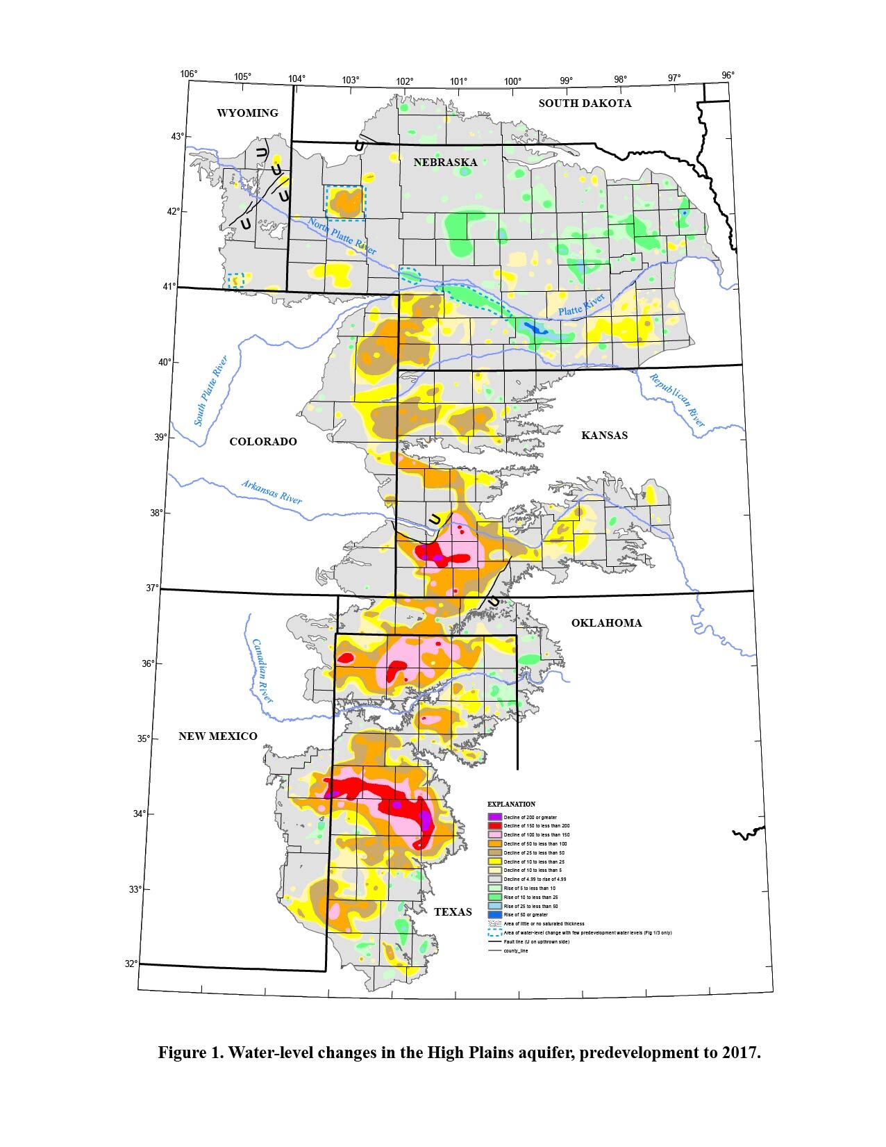
McGuire, V.L., and Strauch, K.R., 2022. Data from U.S. Geological Survey.

In the 1950s, it was thought the water in the aquifer was inexhaustible. More and more wells were drilled to reach the aquifer and new delivery methods, chiefly center point irrigation, revolutionized farming. But unlike surface water such as that found in a river, with a relatively quick recharge from rain and snow, the groundwater in the Ogallala Aquifer is prehistoric. It is recharged on a geological time scale. Now we know the aquifer is not inexhaustible. In some places, such as beneath the community of Jetmore, north of Dodge City, the aquifer is already nearing depletion. That depletion is accelerated by climate change and continued over pumping of water.

Once the water is gone, it’s gone for the rest of our lifetimes — and because geologic recharge is so slow, several hundred or perhaps thousands of lifetimes to come. Kansas Reflector’s Allison Kite, in partnership with Stateline reporter Kevin Hardy, reported in May that despite the grim prognosis, one of the state’s locally controlled water management districts has resisted adopting meaningful water conservation methods.

Southwest Kansas Groundwater Management District 3, perched just above the Oklahoma panhandle in the extreme southwest corner of Kansas, is under fire for its travel expenses, lack of a formal conversation policy and its alienation of farmers who would like to conserve water. Despite a budget of $1 million, it has spent little of it on conservation, although executive director Mark Rude argues everything the district does is in the name of conservation. But in contrast to other districts, District 3 is clearly lagging.

The state’s five groundwater management districts were established in the 1970s, according to the Kansas Geological Survey. In 2020, for example, Groundwater Management District 1 used a state law that allows for the creation of “Limited Enhanced Management Areas” to commit farmers to reduce consumption by 50% over seven years.

By 2026, according to a new state law, all districts — including District 3 — will be forced to submit reports to the Legislature and file a water conservation action plan with the state’s chief engineer.

Much of the resistance in District 3 is cultural. Locals like being in control, dislike being told what to do, and consider their legacy water rights sacred. On the district’s website you can read about how the district was organized to “provide for the stabilization of agriculture by establishing the right of local users to determine their own destiny with respect to the use of groundwater.”

Such declarations ignore the rest of us, who have a reasonable right to expect that prehistoric groundwater in the Ogallala Aquifer should belong to us all. But Kansas water rights are based on the “first in time — first in right” principle, which means the earliest users are given priority.

Kansas Aqueduct route via Circle of Blue

Perhaps the thinking of District 3 officials is best represented by a couple of stunts in which thousands of gallons of Missouri River water was trucked 400 miles to southwest Kansas. The project was meant to drum up support for an aqueduct that would take water from the Missouri River in northeast Kansas to a reservoir in Utica. Since water flows downhill, and taking water to the west in Kansas is literally an uphill battle, 15 pumping stations would be required. The ground-hugging aqueduct — really, just a glorified ditch — would cost an estimated $18 billion to build and another billion a year in ongoing costs.

The Kansas aqueduct is a nutty idea, but one that has taken root among some individuals in western Kansas desperate for a solution to continue irrigation after the depletion of the Ogallala Aquifer. Aside from its expense and impracticality, it is a regressive idea that harkens back to the days of ditches and avoids a conversation about us having squandered the resource beneath our feet. It also ignores any objections the folks on the other side of the Missouri River, in Iowa and Missouri, might have to say about us taking water from a river we share.

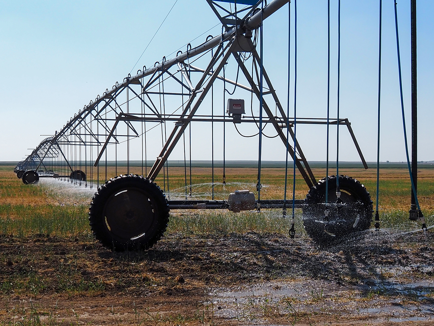
Sprinklers irrigate a field in Hamilton County, Kansas, where some farmers have petitioned to be removed from a local groundwater management district. State lawmakers are pressuring the district to do more to conserve water in the Ogallala Aquifer. (Allison Kite/Kansas Reflector)

The aqueduct is something our 1890s rainmaker, Clayton B. Jewell, might have understood. At least, he might have appreciated how desperate some folks are to believe in a solution that doesn’t really address the problem.

The problem is that agriculture in the state is unsustainable beyond the 100th Meridian without irrigation. Instead of an anomaly, the magnitude of drought that drove the Dust Bowl can be expected to occur with alarming frequency.

“Paleoclimatic data collected for western Kansas indicate a drought as severe as the Dust Bowl occurs there, on average, three to four times a century, according to a Kansas Geological Survey circular. “Based on that probability, there is a 35% chance for a severe drought year in any decade, a 70% chance within a 20-year span, and a 100% chance over the estimated 40-year working lifetime of a western Kansas farmer.”

The new law that requires District 3 to deliver a water conservation action plan was passed in response to the Kansas Water Authority saying last year that the state’s longstanding policy of simply slowing depletion was insufficient to protect the Ogallala aquifer. The law is a step toward the state taking control of water management from local districts if consumption continues to outpace conservation.

The battle over the aquifer’s decline pits good policy against powerful agricultural and political interests. Add to the mix the independence that seems woven into the cultural fabric of southwestern Kansas, and you have the ingredients for a water war that might define the region for decades to come.

But this is one war we may already have lost.

We’ve already killed the Arkansas River in western Kansas, leaving just a dry bed behind. Every other river and stream and creek in that third of the state has also vanished. The natural recharge just isn’t enough to keep water in them. Worse, climate change appears to be driving the arid zone to the east, creating an even bigger water crisis.

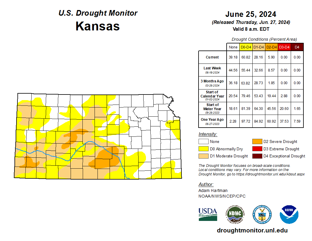
About a third of Kansas counties are currently in a moderate to severe drought, with some of the worst conditions in the area served by District 3, according to the U.S. Drought Monitor. The drought puts pressure on farmers to pump more water instead of voluntarily committing to conserve. It’s difficult to get people to do the right thing when it’s against their economic interests.

If only Jewell’s apparatus had really worked.

The rainmaking railway car was inspected in 1892 by a newspaper reporter who described the mysteries within.

“Inside the laboratory part of the car a wide shelf about two feet from the floor extends from one end to the other,” the correspondent wrote. “On this are many curious-looking bottles and boxes said to contain the chemicals from which the rain producing gases are made.”

There were also pipes, bottles, other laboratory apparatus, and a 24-cell battery. Jewell said the gases produced would rise to 8,000 feet, then condense, creating a vacuum that would be filled with moisture — and produce rain.

“There are many thinking people in Kansas who believe absolutely in Jewell’s rain-making system, and they are encouraging him in every possible way,” wrote the observer. In other quarters, however, Jewell’s work was received with skepticism, and sometimes superstition, as those who prayed for rain regarded his apparatus as the work of the devil.

Jewell died in Coffeyville in 1906, aged 44, from pneumonia.

“For two or three seasons Mr. Jewell did little else besides operating this (rainmaking) car and apparatus,” noted his obituary in the Topeka Capital, “but it was finally abandoned.”

No rainmaker, no aqueduct, and no prayer will save western Kansas from the depletion of the Ogallala Aquifer. The best we can hope for is to reduce consumption, buy a little more time, and adjust to a changing climate and economy. It is time to heed the warning John Wesley Powell gave us so long ago — and prepare for the new Dust Bowl.

Max McCoy is an award-winning author and journalist. Through its opinion section, the Kansas Reflector works to amplify the voices of people who are affected by public policies or excluded from public debate. Find information, including how to submit your own commentary, here.

Rivers of Kansas map via Geology.com

#Aurora defends plans to export #ArkansasRiver Basin water — Heart of the Rockies Radio

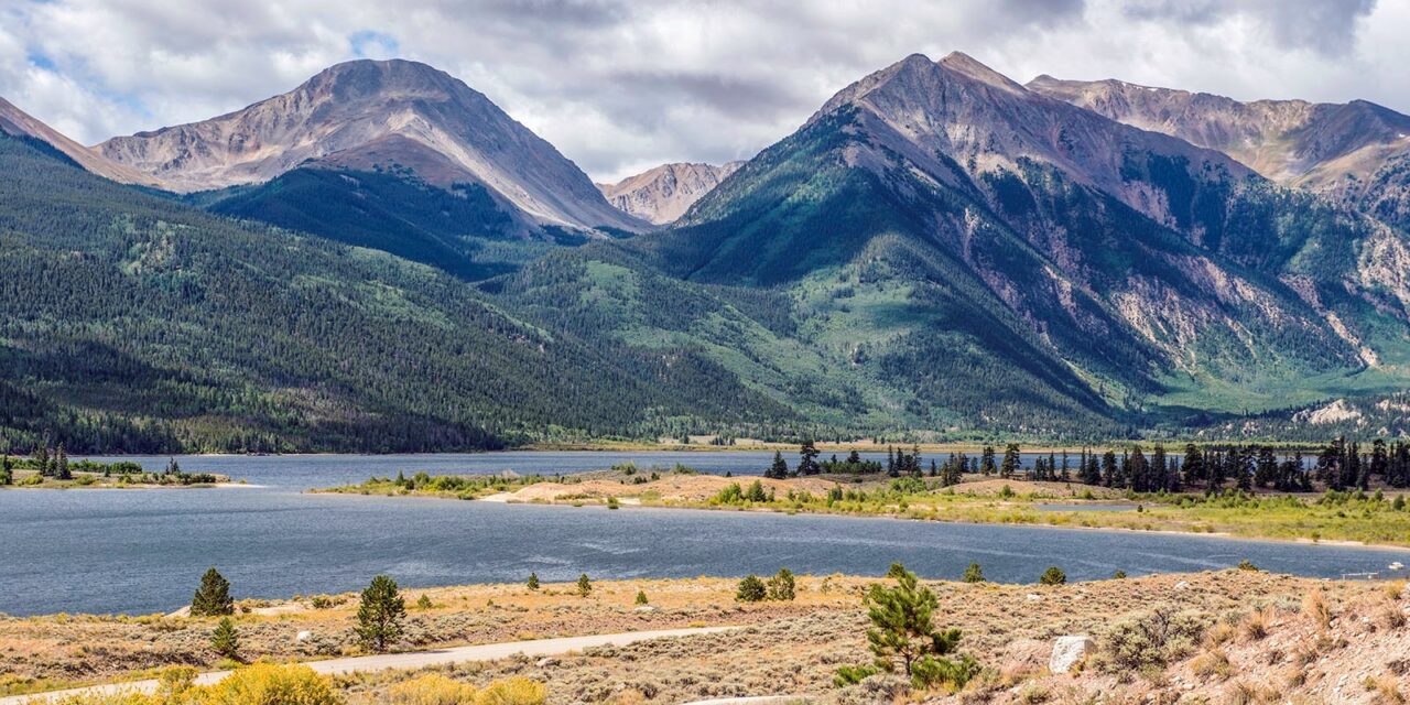
Rocky Mountain vista from State Highway 82 near Twin Lakes, Colorado, U.S.A. Photo credit: Joe Stone/Heart of the Rockies Radio

Click the link to read the article on the Heart of the Rockies Radio website (Joe Stone):

July 1, 2024

Multiple officials with the City of Aurora, the third-largest municipal water provider in Colorado, attended the June board meeting of the Upper Arkansas Water Conservancy District in Salida to discuss their recent purchase of water rights in the Arkansas River Basin.

Aurora paid $80.4 million to buy an Otero County farming operation, including water rights used to irrigate 4,806 acres – about 7,500 acre-feet of water per year, depending on the annual conditions like snowpack and streamflows. Most of those rights are shares in the Catlin Canal Co.

The purchase has been condemned by Chaffee County and the Upper Ark Conservancy District as well as the Southeastern Colorado Water Conservancy District. Both conservancy districts claim that exporting the water to Aurora will violate various terms of intergovernmental agreements, or IGAs, signed in 2003.

The 2003 IGA between Aurora and the Southeastern District states, “Aurora shall not initiate or seek to implement any further permanent transfer of water rights … from sources in the Arkansas River basin” for the next 40 years.

Interruptible Water Supply Agreements

During the meeting, Rick Kienitz, Arkansas Basin water resources manager for Aurora, acknowledged that the city plans to export its newly acquired water three out of every 10 years for at least 30 years using an Interruptible Water Supply Agreement, or IWSA.

IWSAs allow the State Engineer (Division of Water Resources) to approve temporary changes of water use for three out of 10 years without the due process provided by Water Court, which provides a higher degree of protection for water rights that could be injured by changes in water use.

In 2003, the same year that Aurora signed its IGAs with the Southeastern and Upper Ark water conservancy districts, the General Assembly passed legislation (HB 03-1334) allowing these temporary changes of water use.

IWSAs allow water rights owners to lease water for uses other than the court-approved use for that water – e.g., a farmer who owns an irrigation right can lease his water to a city for municipal or industrial use. In this case, Aurora is leasing out the farm and promising to keep the water on the farm for seven out of 10 years.

Prior to 2003, changes of water use had to be approved in Water Court. HB 03-1334 circumvented Water Court, and 10 years later, HB 13‐1130 allowed for IWSAs to be re-approved twice for a total of 30 years.

Aurora was a major supporter of this legislation, which allows the city to export 30% of its Ark Basin water out of the basin over the course of 30 years, and as Kienitz noted, Aurora already gets 25% of its municipal water from the Arkansas Basin.

At the Upper Ark meeting, board member Mike Shields emphasized that Aurora’s plans would take 30% of its newly purchased water out of the basin for decades, which seems to be at odds with the IGAs.

Kienitz asserted that the transfer of this water does not violate the IGAs because it is temporary.

Upper Ark board member Tom Goodwin, who also serves on the Southeastern District board, said the original intent of the IGAs was that “Aurora would not buy more water in the Arkansas Valley.”

Aurora’s plan “seems like a shell game,” Goodwin said. “It gives the impression that, ‘We’ll try to manipulate this any way we can.’ And a lot of our constituents are saying very loudly, ‘Don’t let Aurora take another drop of water.’”

Upper Ark attorney Kendall Burgemeister pointed out that state law does not allow Aurora to use an IWSA “in perpetuity. So eventually, you’ll have to go to Water Court.”

Kienitz said Aurora would “go to the legislature to address that” in order to avoid Water Court, essentially admitting that Aurora will continue to use its political influence to erode state water law enshrined in the Colorado Constitution* – i.e., to continue taking 30% of its Ark Basin water for as long as possible.

Moving Water Upstream

When Upper Ark General Manager Terry Scanga asked if Aurora is planning on drying up all 4,800 acres of farmland in a single year, Kienitz replied, “We can’t rotate acreage” for more than 4,000 acres because the IGAs are more restrictive than the IWSA legislation.

Scanga asked how Aurora plans to move that much water out of the basin in a single year.

“When this is needed, it will be a dry year,” Kienitz responded. “There should be storage space in reservoirs.”

Aurora needs reservoir storage because the process of transferring water from Aurora’s Otero County farming operation into the city’s municipal water system is complicated.

First, it requires a “reservoir exchange” of water – i.e., Catlin Canal water is traded for water stored upstream in Pueblo Reservoir, normally Fryingpan-Arkansas Project water.

Moving water upstream through an administrative or decreed physical exchange is only possible when river flows are sufficient to permit the exchange without injuring senior water rights between the two exchange points.

In dry years exchange potential is limited, but Kienitz did not address this limitation when responding to Scanga’s question.

Little by little, when river flows allow, Aurora can exchange its water into Pueblo Reservoir, built as part of the Fryingpan-Arkansas Project, which brings water into the Arkansas River from the West Slope.

Once Aurora exchanges its Catlin Canal water into Pueblo Reservoir, it plans to trade that water for Fry-Ark Project water in Twin Lakes.

From Twin Lakes, the water could then be diverted and pumped into the South Platte Basin through the Otero Pipeline, jointly owned by Aurora and Colorado Springs.

As stated in the Upper Ark District’s resolution opposing Aurora’s plan, trading water from Pueblo Reservoir for water in Twin Lakes and then exporting it through the Otero Pipeline would reduce Arkansas River flows between Twin Lakes and Pueblo Reservoir.

Preserving Agriculture

Kienitz repeatedly emphasized Aurora’s commitment to preserving agriculture in the Arkansas Basin. He said Aurora plans to maintain ag production on the newly acquired Otero County property by leasing it to “a farming company.”

Upper Ark board member Bill Donley, a rancher in Custer County, asked Keinitz, “How do you keep an alfalfa field if you dry it up?” (Alfalfa is a perennial crop, but in Colorado, it requires irrigation to survive year-to-year.)

“You can’t,” Kienitz replied, so we’ve addressed that through the lease with the farmer to compensate for that loss,” adding that the farmer could also look at growing dryland crops.

According to long-time farmers like Matt Heimrich, attempts at dryland farming on dried-up Ark Basin farmland have not succeeded.

Heimrich farms in Crowley County, which borders Otero County, and he said he’s never seen a dryland crop in Crowley County, nor has his family, which came to the county in the 1950s.

Heimrich told the Colorado Springs Gazette that dryland farming “is a terrible challenge” because soils change after decades of farming. “It’s not that healthy, native soil that you would see on the prairie. … It’s very silty, and when the ground has been used for crop rotation, its ability to sustain dryland seeding or farming is diminished.”

Farmer vs. Developer

The “farmer” with whom Aurora has contracted to run a profitable agricultural business is C&A Companies.

C&A Companies is registered with the State of Colorado as a “holding company,” and its website identifies C&A as “a diversified real estate firm based in Denver.”

The website also states, “C&A and its stakeholders currently own and control one of the largest privately owned water holdings in the West. … The principals … sit on the boards of various metropolitan districts,” which include municipal water operations.

One of those principals is C&A co-founder Karl Nyquist, whose background is in real estate and investment banking.

As Marianne Goodland wrote in a 2018 Colorado Springs Gazette article, “Nyquist isn’t a farmer. He’s a developer with a portfolio of multimillion dollar deals all along the Front Range. He’s also been generous with political contributions over the past half-dozen years.”

Writing for the Pueblo Chieftain in 2011, Chris Woodka reported that Nyquist attempted to export up to 12,000 acre-feet of water per year from the Arkansas Basin to growing Front Range communities in the South Platte Basin.

Nyquist proposed building a $350-million, 150-mile pipeline to move the water but withdrew the proposal in the face of stiff opposition from Lower Ark Basin farming communities.

“Mr. Nyquist claims his pipeline would benefit Prowers County,” reads a Chieftain editorial from 2011. “We think he’s peddling snake oil.”

The Chieftain criticized another of Nyquist’s efforts to remove water from Ark Basin farmland in 2016, stating, “Nyquist has a notorious history of diverting agricultural water from the Arkansas River Valley to the Northern Colorado cities surrounding Denver. … We don’t trust Nyquist.”

Photo: Twin Lakes Reservoir is part of the Fryingpan-Arkansas Project. For Aurora to use its newly acquired water, it will need to get the water into Twin Lakes and then pump it into the South Platte River Basin through the Otero Pipeline.

* During the past 15 years, Ken Baker’s reports to the Upper Arkansas Water Conservancy District have warned that legislative efforts to bypass Water Court are undermining constitutional water law. Baker played a key role in establishing the District, served as its attorney for many years, and consulted with the District on legislative matters until his recent retirement.

Related coverage:
Conservancy District opposes major water purchase by Aurora
Upper Ark District, Chaffee County condemn Aurora water plans

How conservative judges secured a ‘chain saw’ to derail environmental rules — The Washington Post

Coyote Gulch’s Leaf charging at Red Rock Hyundai in Grand Junction May 23, 2023. The Biden administration’s effort to boost sales of electric vehicles while cutting emissions from gasoline-powered vehicles could face a tough test in the courts

Click the link to read the article on The Washington Post website (Maxine Joselow). Here’s an excerpt:

July 1, 2024

Three years ago, President Biden promised to “deliver a whole-of-government approach to the climate crisis,” including by making half of all new cars electricby 2030. Now the Supreme Court has imperiled that broad agenda — and possibly other climate and environment rules for decades to come. In recent rulings, particularly two last week, the high court added obstacles tothe government’s ability to regulate air pollution, water pollution and the greenhouse gases that are heating Earth. The decisions could empower conservative judges on lower courts throughout the country to block even more environmental regulations — not only under Biden but presidents who follow him. The recent rulings are “especially valuable for conservative judges who are inclined towards striking down [environmental] regulations,” said Sam Sankar, senior vice president for programs at the environmental law firm Earthjustice. “They had a knife before; they have a chain saw now.”

On Thursday, the Supreme Court put on hold the Environmental Protection Agency’s plan for cutting industrial air pollution that wafts across state lines. On Friday, the justices overturned the so-called Chevron doctrine, severely limiting the power of federal agencies to regulate fundamental aspects of American life, including the environment. And court rulings in 2022 and 2023 targeted the EPA’s authority to curb greenhouse gases and to protect wetlands from runoff. Together, the decisions underscore how a multiyear campaign by industry and conservative groups is successfully weakening the power of the administrative state, and the EPA in particular.

Group to focus on water for the environment: State officials want more flow targets in stream management plans — @AspenJournalism #EagleRiver

The Eagle River, left, flows into the Colorado River near Dotsero. The Eagle River Coalition recently completed its community water plan, which outlines environmental flow deficits, but does not make recommendations on how to get more water into rivers. CREDIT: BETHANY BLITZ/ASPEN JOURNALISM

Click the link to read the article on the Aspen Journalism website (Bethany Blitz):

June 13, 2024

In an effort to elevate the needs of the environment in water management, the state of Colorado is convening a new committee that is scheduled to begin meeting this summer. 

The Colorado Water Conservation Board and Boulder-based nonprofit River Network are creating a pilot program known as the Environmental Flows Cohort, which will assess how much water is needed to maintain healthy streams and how to meet these flow recommendations. The cohort will include not just environmental advocates, but agricultural and municipal water users, who may initially feel threatened by environmental flow recommendations. 

The goal of the program is to address the barriers that lead to these recommendations being excluded from local stream management plans. The cohort was one of the recommendations in a January 2023 analysis of SMPs by the River Network.

“The idea is how can the environmental and recreation side of things better partner with the agricultural users on trying to find win-win projects for keeping more water in the stream,” said Brian Murphy, director of the healthy rivers program at the River Network. “An emphasis on making sure stream management plans identify and prioritize projects that include environmental flows, that’s been kind of a shortfall.”
An objective of Colorado’s 2015 Water Plan was to create SMPs for most of the state’s important streams by 2030. SMPs are meant to focus on water for the environment and recreation, which are “nonconsumptive” needs where “using” the water means that it stays in streams. The idea is that these flow targets could then result in projects designed to get that agreed-upon amount of water in streams.

SMPs were originally intended as a tool to legitimize and enhance the role of environmental and recreation groups in water management, but a 2022 report by the River Network found that focusing on water to maintain a healthy environment was inconsistent, problematic and unpopular among the stakeholders who were creating the SMPs. Just 6% of project recommendations at the time focused on environmental flow targets and only 1% focused on recreation flow targets, even though SMPs were supposed to have been a tool specifically for the benefit of nonconsumptive water uses. 

In some cases, the SMPs broadened in scope and morphed into Integrated Water Management Plans that included an agricultural water needs assessment and ditch inventories.

“One of the big challenges, it was found, was just a lot of perceived negativity regarding flow recommendations,” said Andrea Harbin Monahan, a watershed scientist with CWCB. “There’s a perceived animosity between the recreation community versus agriculture, for example. Figuring out a way to get all those people into one room and start those conversations early and build trust early in the process are hopefully the outcomes of this environmental cohort.”

Under the bedrock principle of Colorado water law, the oldest water rights, which belong to agriculture and cities, get first use of rivers and other user groups have historically had trouble making inroads. The actions of the biggest irrigators often have an influence on how much water is left flowing in the stream, and there are few ways to guarantee there is enough for ecosystems and wildlife. The CWCB holds instream flow water rights intended to “preserve the natural environment to a reasonable degree.” But the oldest of these date to the 1970s — about a century younger than the most powerful agricultural water rights, which limits their effectiveness. 

As climate change squeezes water supply and creates shortages for all users, it also ratchets up the tension between groups that take water out of the river and groups that want to leave it in. 

Homestake Creek is a tributary of the Eagle River. The Eagle River Coalition recently completed its community water plan, which outlines environmental flow deficits, but does not make recommendations on how to get more water into rivers. CREDIT: BRENT GARDNER-SMITH/ASPEN JOURNALISM

Eagle River Community Water Plan

The Eagle River Coalition is an organization dedicated to advocating for the health of the Eagle River. After five years of community meetings and technical work, the group recently released the Eagle River Community Water Plan. The plan provides an assessment of current conditions on the Eagle and its tributaries, and what conditions may look like with future risks such as climate change, more municipal water demands and new reservoir projects that take more water to the Front Range. 

“The main takeaway to me is that we’re going to see low flows and less water in the river, so we as a community have to figure out how are we going to prioritize keeping our river flowing,” said James Dilzell, executive director of the Eagle River Coalition. “Figuring out how to have more water in the river is going to be absolutely critical.”

The plan is meant, in part, to provide an understanding of environmental and recreational needs gaps and how they are affected by high and low flows and increasing demands for water in Eagle County and on the Front Range. 

But although the plan includes a section about environmental flow deficits, which is the amount of water that would be needed to meet the CWCB’s instream flow water right during a typical year, it — like most SMPs — does not set a target amount for flows. 

This map in the Eagle River Community Water Plan shows the environmental flow deficits on the Eagle River and its tributaries. The EDFs reflect the amount of water that would be needed to meet the Colorado Water Conservation Board Instream Flow water right in a typical year. CREDIT: EAGLE RIVER COMMUNITY WATER PLAN

Seth Mason, a hydrologist with Carbondale-based Lotic Hydrological, helped author the Eagle River plan and will be participating in the cohort. He said putting a number on exactly how much water the river needs at different times of year under different future climate and development scenarios is complicated. For example, it might be the case that the only way for a section of river to meet a certain flow target is to build a reservoir to control releases, but a new reservoir project could be at odds with what the community wants. 

“What we didn’t do was develop a prescriptive flow regime,” Mason said. “And that, I think, is what a lot of people end up looking for. … I think providing the nuance necessary for people to do critical thinking about trade-offs is more valuable than drawing the perfect stream flow regime, which there is no such thing.”

Dilzell said he is interested in learning more about flow recommendations on the Eagle River and its tributaries, and the completion of the community water plan is just the first step in local watershed management.

Still, river flows can be a proxy for ecosystem health, and some say target recommendations are essential. Bart Miller, healthy rivers director with environmental group Western Resource Advocates, said stream flow recommendations are the bedrock for protecting the environment. WRA is helping to facilitate the cohort.

“Flow has an impact on water quality, temperature, habitat — everything from spawning cues for fish to just keeping them alive when flows are getting low at the end of the summer,” Miller said. “There’s a wide range of benefits from having a clear picture of what stream needs are and articulating recommendations on how to improve or protect what the flows look like.”

Although they are not required in order to get state funding for SMPs, CWCB officials would still like the groups that develop SMPs to come up with flow recommendations. Harbin Monahan said the cohort will be a way to work through barriers, understand the contentious nature of the topic and build trust among stakeholders so that more SMPS can have flow recommendations in the future. 

“The entire idea behind stream management plans was to help support the environment and recreation community and help them meet the flow needs for specific uses,” she said. “It’s OK if stream management plans don’t come out with a flow recommendation. It’s not typically required, but it is a desired outcome.”

The River Network and CWCB are taking applications for the Environmental Flows Cohort and plan to choose 15 to 20 participants to begin meeting in July. The cohort plans to meet five times between July and next spring and will develop a training program for local watershed groups to follow when they create SMPs. 

This story ran in the June 17 edition of The Aspen Times and the Glenwood Springs Post-Independent, the Craig Daily Press, the Steamboat Springs Pilot & Today and the Grand Junction Daily Sentinel.

Map of the Eagle River drainage basin in Colorado, USA. Made using USGS data. By Shannon1 – Own work, CC BY-SA 4.0, https://commons.wikimedia.org/w/index.php?curid=69310517

In #Colorado, new scrutiny and possible fixes coming for drinking water in mobile home parks: State officials got a head start on a new testing program at one community in Western Colorado — The Water Desk

New Castle back in the day via the Red Slipper Diary

Click the link to read the article on The Water Desk website (Eleanor Bennett):

May 16, 2024

In western communities, mobile home parks provide a more affordable place to live, but residents often face problems with their drinking water. 

In Colorado, a new law gives the state authority to test water quality in these communities and force owners to fix any issues.

The state plans to start testing the water at hundreds of parks across the state this summer. Officials have already gotten a head start at one community in Western Colorado that helped spur the legislation.

Apple Tree Park sits on the banks of the Colorado River just across from the town of New Castle. 

Silvia Barragán moved to the park in 2015. Her street is lined with trees and she has a big yard with a garden. 

“Some people might look at this as just a trashy mobile park, but it’s not,” Barragán said. “It’s a nice, nice neighborhood. There’s a lot of kids in the summer running around and there’s a lot of elderly people that have lived here most of their lives.”

Barragán is originally from Michoacán, Mexico, and she raised her family in western Colorado. Her experience at Apple Tree Park over the last decade has mostly been positive. 

“Since I moved here, I felt peaceful and at home,” Barragán said. “My neighbors are great neighbors and I haven’t had any issues in Apple Tree except the water.”

For years, Barragán and her neighbors have been speaking out about the discolored water that comes out of their taps. 

“It’s kind of brownish, yellowish. It’s kind of nasty,” she said. “It’s like river water, like if I’m camping and I go get river water, that’s what it looks like.”

Barragán only wears black now because the water stains her clothes and laundry, and it ruins her appliances.

It has an unpleasant smell and taste, so she fills up water jugs at the local grocery store.

“I buy water,” Barragán said. “I buy water for cooking, I buy water for drinking, I buy water for the dogs.” 

When the state tested the water at Apple Tree Park, they found it meets federal EPA standards under the Safe Drinking Water Act, passed in 1974, but it has higher than normal levels of heavy metals such as iron and manganese. The park is supplied by groundwater wells, and is outside the limits of the nearby town of New Castle, which draws the majority of its drinking supply from a nearby creek.

Joel Minor used to manage the Colorado Department of Public Health and Environment’s environmental justice program, and said Apple Tree’s situation — of heavy metals showing up in underground well water — is pretty common. 

“Because of the taste and color and odor of the water, it can be unpleasant to drink and can cause other issues,” Minor said. “We recognize that that creates challenges for park residents and may require them to spend money on things like bottled water or repairing or replacing appliances.”

While Apple Tree’s overall water system meets federal health standards for drinking, a recent round of testing this winter found that a few samples out of the 200 taken had manganese levels that were above the EPA’s health advisory for infants. High levels of manganese can negatively impact babies’ brain development.

When the state got the test results back in February, they worked with the park owner—Utah-based company Investment Property Group (IPG)—to notify residents and local health officials about the issue. 

“What we want folks to know is to be cautious about using tap water from the park for making formula for infants under the age of six-months-old,” Minor said. “These particular locations where this occurred seem to be spots where maybe the water isn’t being flushed quite as well.”

With the passage of the Mobile Home Park Water Quality Act in 2023, the state’s been working with IPG to do more regular testing and to fix the water issues. The company didn’t respond to multiple requests for comment. 

In 2020, IPG bought the mobile home park from the local Talbott family, which had owned the park since its inception. The company has properties across 13 states, including more than 110 mobile home parks, according to the Mobile Home Park Home Owners Allegiance’s online database.

The state has been having regular meetings with IPG, Garfield County health officials, local advocacy groups and park residents to come up with a variety of ways to improve the water. 

“One key short-term solution that we’ve been working with the park on is flushing the water system more frequently, which can help remove iron and other metals that have accumulated in the system,” Minor said. “We’ve also worked with that same coalition to put on an informational webinar about how to do in-home flushing for appliances like water heaters and pipes so that residents are also able to flush their own water systems.”

Another short-term fix already underway is putting in water stations where residents can fill up jugs for cooking and drinking. 

The state is providing direct funding to the park in the form of an assistance grant to help install these stations. One has already been installed at a local school across from the mobile home park that’s also owned by IPG, and the company plans to install a second by early June in a communal area near the entrance to the park. 

“That was something we came up with based on feedback from park residents that folks are having to drive across the river and across the highway into New Castle to fill water jugs for drinking and other purposes,” Minor said. “So these are key short-term solutions, but we recognize they don’t address the root cause of the problem.”

To address the root cause, the state is proposing bigger engineering solutions like installing a filtration system, or even connecting Apple Tree to a municipal water supply. 

But Apple Tree is just one of about 750 mobile home parks in Colorado. The new legislation gives the state authority to test, but the full scope of just how bad water quality could be at those parks, and the costs to fix the various causes could easily begin to rise as testing ramps up.

There is additional funding available for park owners to make these system-wide changes, and if they don’t, the state could impose fines until the problem is fixed. 

“We are really trying to prioritize solutions that won’t increase rent for park residents by either looking at lower cost options or ways of getting outside funding that can ensure that some of those costs don’t get passed on to residents,” Minor said. “We know that passing along the cost could potentially make the equity challenges that are already at play worse if residents have to pay more for their water bills or their space rents.”

Alex Sanchez leads the Glenwood Springs-based Latine advocacy nonprofit Voces Unidas, which worked with Apple Tree residents and Democratic Colorado House Representative Elizabeth Velasco of Glenwood Springs to pass the water quality legislation. 

“We’re not opposed to getting state dollars and federal dollars to be able to support or incentivize some of these solutions,” Sanchez said. “But ultimately, we believe it’s the responsibility of those corporate owners who have been making a lot of profit off the backs of hardworking folks without having access to, you know, quality water, potentially sidewalks, infrastructure and other benefits that many of us take for granted.” 

For Sanchez and Voces Unidas, the new law is just the first step in addressing a widespread environmental justice issue — many people living in these communities have lower incomes, don’t speak English as a first language, don’t have access to resources to file complaints, and are Latines or other people of color. 

“The issue is not just contained to one or two parks. Something is happening in these mobile home park communities and because they’re not regulated, there’s not a lot of accountability,” Sanchez said. “Many of these communities across Colorado are owned by corporations that are from out of state.” 

In a recent statewide poll in Colorado, Voces Unidas found 41% of mobile home park residents surveyed did not trust or drink their water. 

Since 2020, the state’s health and environment department has received 66 formal water quality complaints from 42 parks. State officials estimate that it will take them four years to test the water at all of Colorado’s roughly 750 parks. 

For her part, Apple Tree Park resident Silvia Barragán is glad that her community is at the top of the state’s list. 

“When I bought this place, I thought I was gonna retire here,” Barragán said. “So I would be sad to think that I need to buy another place just because, you know, I haven’t seen any change.”

Barragán hopes the new legislation will speed things up, but she doesn’t know how much longer she can wait for clean water. 

This story was produced by Aspen Public Radio, in partnership with The Water Desk, an independent initiative of the University of Colorado Boulder’s Center for Environmental Journalism. 

‘Let’s get this river fixed up’: #ColoradoRiver to benefit from restoration efforts proposed as part of land exchange in Summit and Grand counties — Summit Daily #BlueRiver #COriver #aridification

Map of the Blue River drainage basin in Colorado, USA. Made using USGS data. By Shannon1 – Own work, CC BY-SA 4.0, https://commons.wikimedia.org/w/index.php?curid=69327693

Click the link to read the article on the Summit Daily website (Ryan Spencer). Here’s an excerpt:

June 8, 2024

The restoration work is proposed along a section of the Blue River near its confluence with the Colorado River in Kremmling

If a land exchange in Summit and Grand counties is completed, this ¾ mile stretch of the river could be Rosgen’s next project. The Bureau of Land Management approved the Blue Valley of Land Exchange last year. After dismissing public protests against the exchange last month, the federal bureau is now queuing up the final steps required to complete the land swap. The land exchange between the federal government and Blue Valley Ranch, which is owned by billionaire Paul Tudor Jones II, has been decades in the making. It was first proposed in some form in 2001 with the stated purpose of addressing the “checkerboard nature” of ownership in the area.

A map shows the existing public and private parcels, left, as well as how the land ownership would change if the Blue Valley Ranch land exchange goes through. `Bureau of Land Management/Courtesy illustration

As part of the deal, the federal government would convey nine parcels totaling 1,489 acres to Blue Valley Ranch, while the ranch would transfer nine parcels of private land totaling 1,830 acres to public ownership. Blue Valley Ranch has also agreed to provide Summit County with $600,000 for new open space acquisitions as well as to construct a seasonal takeout and rest stop near the Spring Creek River Bridge and another rest stop 3 miles downstream. But Rosgen said what makes the land exchange a “win-win,” in his eyes, is Blue Valley Ranch’s commitment to cover the costs of river restoration work on that ¾ mile stretch, and the creation of the Confluence Recreation Area, which would have more than 2 miles of new walking trails and offer wheel-chair accessible fishing.