Over the past week, remnants of Beryl made their way up into the Midwest, bringing with them significant precipitation from east Texas all the way into Michigan. Another shot of significant rain at the end of the current period in the Midwest kept the region quite wet overall. Significant precipitation along the eastern seaboard from New Jersey into the Carolinas was welcomed, but isolated to coastal areas. Much of the rest of the country was quite dry with only pockets of light precipitation. The warmest temperatures were over the West, with departures of 3-6 degrees above normal widespread, and from Washington to California, with departures 9-12 degrees above normal. The coolest temperatures were also associated with areas that picked up the best rains as temperatures from Texas into Arkansas and Missouri were up to 3 degrees below normal. Areas of the Northeast were also warmer than normal with departures of 6-9 degrees above normal…
A few pockets of above-normal precipitation were recorded in northwest South Dakota and north central North Dakota as well as in areas of eastern Kansas at the end of the current period. Much of the rest of the region was dry or received minimal amounts of precipitation. Abnormally dry conditions were expanded in northwest and southeast Kansas as well as in eastern Colorado and western Nebraska. Moderate drought was introduced over eastern Colorado and expanded in northwest Nebraska and southwest South Dakota as well as in eastern portions of Wyoming. Moderate and severe drought expanded in central Colorado as the foothills remained dry. After several weeks of wet weather, some drying out is taking place in portions of the region, which is welcomed in some circumstances…
Colorado Drought Monitor one week change map ending July 16, 2024.
Warmer-than-normal temperatures dominated the region, with only portions of western Colorado and New Mexico below normal for the week with departures of up to 3 degrees below normal in New Mexico. Portions of central Washington and Oregon into northern California had temperatures 9-12 degrees above normal. Isolated rains in New Mexico and Arizona as well as portions of central California were the only precipitation events of significance in the region. In response to the recent heat and dryness, a large swath of abnormally dry conditions was expanded this week from northern Nevada and southern Idaho into northern Utah. Abnormally dry conditions were also expanded in northwest California, western Nevada, southern Colorado and southwest Utah. Moderate drought was expanded over more of central Oregon with more abnormally dry areas added in the west. Moderate drought was expanded in western Wyoming, and Montana had severe drought expand broadly in the west while a new pocket of extreme drought was introduced…
It was a mostly dry week over the region with much of the area experiencing temperatures that were 2-3 degrees below normal. With short-term dryness returning to portions of north Texas and southern Oklahoma, abnormally dry conditions were expanded this week. Throughout the rest of the region, no other significant changes were made this week, with status quo common across the region…
Looking Ahead
Over the next 5-7 days, an active pattern appears to be developing from the Southwest, Plains, and into the Southeast and eastern seaboard. The most significant precipitation is anticipated over New Mexico, southern Colorado, northeast Texas, and from Louisiana through Virginia. Dry conditions are anticipated over much of the West and Midwest during this period. Cooler-than-normal temperatures are anticipated over much of the Plains, South and into the Southeast, with some departures from normal approaching 9-11 degrees below normal in portions of Nebraska, Kansas and into Colorado and New Mexico. Warmer-than-normal temperatures will dominate the West with departures of 11-13 degrees above normal over the Great Basin and into the northern Rocky Mountains. Near-normal temperatures are anticipated over other areas.
The 6-10 day outlooks show that the greatest chances of below-normal temperatures will be over the southern Plains into portions of the South, Southwest and southern Midwest. The greatest probability of experiencing above-normal temperatures during this time will be over the West and the Florida peninsula and portions of the Northeast. The highest probability of above-normal precipitation will be over Texas with the area from the Southwest into the Mid-Atlantic also expected to have above-normal chances of above-normal precipitation. The area with the greatest chances of below-normal precipitation will be over the northern Rocky Mountains into the northern High Plains.
US Drought Monitor one week change map ending July 16, 2024.
American beaver, he was happily sitting back and munching on something. and munching, and munching. By Steve from washington, dc, usa – American Beaver, CC BY-SA 2.0, https://commons.wikimedia.org/w/index.php?curid=3963858
From email from the Beaver Institute (Matt Moseley):
BOULDER, Colo – As drought, climate change and wildfires become more challenging around the country, the intriguing beaver has become a hot topic these days.
BeaverCON is the premier global gathering for knowledge-sharing and celebration of beavers. The Beaver Institute will host the third biennial global gathering on October 19-24 at the University of Colorado Boulder. It will feature presentations, science, field trips, panels, discussion, art and storytelling about the castor canadensis.
“Beavers are more important than ever in water management and creating habitat,” said Adam Burnett, executive director of the Beaver Institute. “This conference is an opportunity for multiple organizations, disciplines, and experiences to converge and learn how to create a future of ecological balance with beavers. We are thrilled with the speakers and energy around this unique and special conference.”
Highlights of BeaverCON:
Saturday, October 19: Cameron Peak Wildfire Field Trip with Dr. Emily Fairfax.
Sunday, October 20: Urban Beaver Field Trip
Monday, October 21: Opening Ceremony with Tribal Recognition, activating of Artist Commission; featured presenters include Dr. Emily Fairfax on wildfires, USDA FSA Administrator Zach Ducheneaux on beavers and farmers, Dr. Ellen Wohl on beavers in Colorado, California’s Natural Resources Secretary Wade Crowfoot on beaver reintroduction, Brock & Kate Lundquist on the Bring Back the Beaver Campaign, and Jim Vaile & Alicia Yellow Owl on Blackfeet Nation’s beaver management plan.
Tuesday, October 22: Multiple speakers on beaver-related restoration, coexistence, relational conservation, partnering with Tribal Nations, youth leadership, subsistence living, relocation, and policy. Leading voices in the field Molly Alves, Mark Beardsley, Dr. Roisin Campbell-Murphy, Janine Castro, Derek Gow, Dr. Chris Jordan, Dr. Jordan Kennedy, Sarah Marshall, Torrey Ritter, Gerhard Schwab, Dr. Colin Thorne, and Alexa Whipple, will present and participate in panels. A Beaver Storytelling Circle will be held at the Dairy Arts Center in the evening.
Wednesday, October 23: A sprawling “State of the Beaver Union” session, Low-Tech Process-Based Restoration (LTPBR) technical sessions, film screenings, and presentations on permafrost, rewilding, youth leadership, policy, and more.
Thursday, October 24: Wetland Field Trip and a beaver coexistence workshop with Mike Callahan (Beaver Solutions, Beaver Institute)
Photo of a zebra mussel veliger discovered by CPW in the Colorado River near Grand Junction after routine testing in early July. A veliger is the mussel’s free-floating (planktonic) larval stage that can only be seen under a microscope. Photo Credit: CPW
Colorado Parks and Wildlife (CPW) announces the discovery of zebra mussel veligers in the Colorado River and Government Highline Canal after routine testing in early July.
On July 1, staff from CPW’s Aquatic Nuisance Species (ANS) team collected a plankton sample from the Government Highline Canal near Clifton. This sample was evaluated at the ANS Lab in Denver where a suspected single zebra mussel veliger was found. The Sample was then sent to CPW’s Aquatic Animal Health Lab (AAHL) for further analysis. On July 9, the lab notified Robert Walters, Invasive Species Program Manager, that the sample was positive for zebra mussel DNA.
The Government Highline Canal, in Palisade. The Government Highline Canal near Grand Junction. The Grand Valley Water Users Association, which operates the canal, has been experimenting with a program that pays water users to fallow fields and reduce their consumptive use of water. Photo: Brent Gardner-Smith/Aspen Journalism
On July 8, CPW ANS staff collected plankton samples from two locations in the Colorado River upstream of the Grand Valley Water Users Canal diversion. On July 10 ANS technicians identified single suspect zebra mussel veligers in both samples. The samples were sent to the AAHL for confirmation. On July 11, the lab confirmed the samples were positive for zebra mussel DNA.
With single detections in both waters, these locations are now considered “suspect” for the presence of zebra mussels. In response to this detection, CPW has initiated their Invasive Species Rapid Response Plan and increased sampling is underway to determine if the classification should be changed to “positive,” a designation given when two or more subsequent sampling events detect mussel veligers in a water body.
A veliger is the free-floating (planktonic) larval stage of the mussel. At this stage of their life cycle, zebra mussels can only be seen under a microscope. No adult zebra mussels have been found at this time at either location.
“This challenging discovery has ecological and economic impacts not only on the Grand Valley but potential statewide impacts as well. CPW is committed to working with all of our partners as we work to better understand the extent of this discovery and the next steps in protecting the natural resources and infrastructure,” said CPW Director Jeff Davis.
Zebra mussels pose an extreme risk of ecological impacts to Colorado. The establishment of zebra mussels in the Colorado River is likely to negatively impact native fish populations due to their filter-feeding strategies that strip essential prey items, such as plankton, from the water. Slower-moving sections of the Colorado River, such as pools, eddies, and backwaters, are especially prone to invasion.
Zebra mussels also pose a risk to infrastructure that pulls water from the Colorado River. Female zebra mussels can produce up to 1,000,000 eggs in a spawning season. As they mature, the mussels bond to surfaces with byssal threads making them extremely difficult to remove. This rapid reproduction coupled with their attachment by byssal threads can lead to clogged water infrastructures creating long-term maintenance issues.
“We are disappointed in the situation we find ourselves in,” said Ed Warner, Area Manager, BOR Western Colorado Area Office. “We know how much effort CPW has put into keeping the Colorado River clear of zebra mussels. This is an extremely difficult scenario for all who rely on the Upper Colorado River system. We look forward to partnering with CPW, our stakeholders, and all involved to do what we can to address the situation.”
“This news is devastating,” said Tina Bergonzini, Grand Valley Water Users Association General Manager “Having our canal and the Colorado River test positive increases the threat of this invasive species and could impact everyone in the Grand Valley. From irrigation to drinking water, the ramifications cannot be underestimated or overstated. Our efforts, alongside our partners at CPW and the BOR, will be increased to protect our infrastructure, the livelihoods of so many, and water security for us all.”
CPW staff will continue working closely with our partners at the Bureau of Reclamation and Grand Valley Water Users Association on the next steps. Signs alerting the public of the river status will be posted at river access points starting in the De Beque Canyon to the Loma Boat Ramp.
“Detecting mussels in the Colorado River highlights how critical it is for boaters, paddlers, anglers, and any person recreating in Colorado’s waters to do their part in preventing the spread,” said Robert Walters, Invasive Species Program Manager.
CPW strongly encourages anyone boating, floating, paddling, or fishing in the Colorado River to clean, drain, and dry their vessels and equipment, including motorized boats, rafts, paddle boards, kayaks, and fishing gear after exiting the river.
CPW is evaluating options for the future management of Highline Lake based on this new information. Updates regarding access, fishing regulations, and water management will be provided once those decisions have been made.
Questions from the media for the Bureau of Reclamation can be directed to BOR Public Affairs Specialist Justyn Liff at 970-248-0625 or jliff@usbr.gov.
Questions from the media for the Grand Valley Water Users Association can be directed to GVWAU General Manager Tina Bergonzini at 970-242-5065 or tbergonzini@gvwua.com.
🚨 This is big news—we’ve discovered zebra mussel larvae in the Colorado River and Government Highline Canal near Grand Junction. No adult zebra mussels have been found at this time. pic.twitter.com/HIPoau5PQd
— Colorado Parks and Wildlife (@COParksWildlife) July 16, 2024
SPANISH TRANSLATION:
CPW anuncia el descubrimiento de mejillones cebra en el río Colorado y el canal Highline del Gobierno
GRAND JUNCTION, Colorado. – El Departamento de Parques y Vida Silvestre de Colorado (CPW, por sus siglas en inglés) anuncia el descubrimiento de veligers de mejillón cebra en el río Colorado y el canal Government Highline después de hacer pruebas de rutina al principio de julio.
El 1 de julio, el personal del equipo de Especies Acuáticas Molestas (ANS) de CPW recolectó una muestra de plancton del Canal Highline del Gobierno, cerca de Clifton. Esta muestra fue evaluada en el Laboratorio ANS en Denver, donde se encontró un presunto veliger de mejillón cebra. Luego, la muestra se envió al Laboratorio de Salud de Animales Acuáticos (AAHL) de CPW para más análisis. El 9 de julio, el laboratorio notificó a Robert Walters, Gerente del Programa de Especies Invasoras, que la muestra era positiva de ADN de mejillón cebra.
El 8 de julio, el personal de CPW ANS recolectó muestras de plancton de dos lugares en el río Colorado aguas arriba del desvío del Canal de Usuarios de Agua de Grand Valley. El 10 de julio, un técnico de ANS identificó a un solo sospechoso de mejillón cebra en ambas muestras. Las muestras se enviaron a la AAHL para su confirmación. El 11 de julio, el laboratorio confirmó que las muestras eran positivas de ADN de mejillón cebra.
Con detecciones únicas en ambas aguas, estos lugares ahora se consideran “sospechosos” de la presencia de mejillones cebra. En respuesta a esta detección, CPW ha iniciado su Plan de Respuesta Rápida de Especies Invasoras y se está llevando a cabo un aumento de muestreo para determinar si la clasificación debe cambiarse a “positiva”, una designación que se da cuando dos o más eventos de muestreo posteriores detectan mejillones veligers en agua.
Un veliger es la etapa larvaria flotante (planctónica) del mejillón. En esta etapa de su ciclo de vida, los mejillones cebra solo se pueden ver bajo un microscopio. No se han encontrado mejillones cebra adultos en este momento en ninguno de los dos lugares.
“Este desafiante descubrimiento tiene impactos ecológicos y económicos no solo en el Gran Valle, sino también posiblemente en todo el estado. CPW está comprometido a trabajar con todos nuestros socios para comprender mejor el alcance de este descubrimiento y los próximos pasos para proteger los recursos naturales y la infraestructura”, dijo el director de CPW, Jeff Davis.
Los mejillones cebra representan un riesgo extremo de impactos ecológicos para Colorado. Es probable que el establecimiento de mejillones cebra en el río Colorado tenga un impacto negativo en las poblaciones de peces nativos debido a sus estrategias de alimentación por filtración que despojan del agua a las presas esenciales, como el plancton. Las secciones más lentas del río Colorado, como pozas, remolinos y remansos, son especialmente propensas a la invasión.
Los mejillones cebra también representan un riesgo para la infraestructura que extrae agua del río Colorado. Las hembras de mejillón cebra pueden producir hasta 1,000,000 de huevos en una temporada de desove. A medida que maduran, los mejillones se adhieren a las superficies con hilos bisales, lo que los hace extremadamente difíciles de eliminar. Esta rápida reproducción, junto con su fijación por roscas bisales, puede provocar la obstrucción de las infraestructuras de agua, lo que crea problemas de mantenimiento a largo plazo.
“Estamos decepcionados con la situación en la que nos encontramos”, dijo Ed Warner, Gerente de Área de la Oficina del Área Occidental de Colorado de BOR. “Sabemos cuánto esfuerzo ha puesto CPW para mantener el río Colorado libre de mejillones cebra. Este es un escenario extremadamente difícil para todos los que dependen del sistema del río Colorado. Esperamos asociarnos con CPW, nuestras partes interesadas y todos los involucrados para hacer lo que podamos para abordar la situación”.
“Esta noticia es devastadora”, dijo Tina Bergonzini, Gerente General de la Asociación de Usuarios de Agua de Grand Valley, “El hecho de que nuestro canal y el río Colorado den positivo aumenta la amenaza de esta especie invasora y podría afectar a todos en Grand Valley. Desde el riego hasta el agua potable, las ramificaciones no pueden subestimarse ni exagerarse. Nuestros esfuerzos, junto con nuestros socios en CPW y BOR, se incrementarán para proteger nuestra infraestructura, los medios de vida de tantas personas y la seguridad hídrica para todos nosotros”.
El personal de CPW continuará trabajando en estrecha colaboración con nuestros socios en la Oficina de Recuperación y la Asociación de Usuarios de Agua de Grand Valley en los próximos pasos. Se colocarán letreros que alerten al público sobre el estado del río en los puntos de acceso al río, comenzando en el cañón De Beque hasta la rampa para botes de Loma.
“La detección de mejillones en el río Colorado pone de manifiesto lo importante que es para los navegantes, remeros, pescadores y cualquier persona que se recree en las aguas de Colorado hacer su parte para prevenir la propagación”, dijo Robert Walters.
CPW recomienda encarecidamente a cualquier persona que navegue, flote, reme o pese en el río Colorado que limpie, drene y seque sus embarcaciones y equipos, incluidos botes motorizados, balsas, tablas de remo, kayaks y equipos de pesca después de salir del río.
CPW está evaluando opciones para la futura administración del lago Highline en función de esta nueva información. Las actualizaciones sobre el acceso, las regulaciones de pesca y la gestión del agua se proporcionarán una vez que se hayan tomado esas decisiones.
Las preguntas de los medios de comunicación para la Oficina de Reclamación pueden dirigirse al especialista en asuntos públicos de BOR, Justyn Liff, al 970-248-0625 o jliff@usbr.gov.
Las preguntas de los medios de comunicación para la Asociación de Usuarios de Agua de Grand Valley pueden dirigirse a la Gerente General de GVWAU, Tina Bergonzini, al 970-242-5065 o tbergonzini@gvwua.com.
Click the link to read the article on the Sibley’s Rivers website (George Sibley):
July 17, 2024
In the last post, I suggested that the Colorado River Compact with its ‘temporary equitable division’ into two basins could now be considered irrelevant (or worse, obstructive) because we have finally effectively accomplished, over the past century, the goal that brought the seven-state Compact commission together in 1922, but which they were unable to achieve then: a seven-way division of the use of the river’s waters.
They wanted a legally constituted seven-way division that would override the appropriation doctrine at the interstate level, to avoid a seven-state horserace for water in which California was already lapping the field, but in 1922 they lacked, for that goal, both a sufficient knowledge of the river’s flows and reasonable expectations for their own growth. Finally they settled on the two-basin division that was, from the start, problematic (Arizona refused to even ratify it), but which sufficed to persuade Congress that the states were enough in agreement so that Congress could go ahead with funding the big mainstem structures the Bureau of Reclamation was champing at the bit to build (perhaps the real goal of the Compact).
But now, after a century of Colorado River development, we ought to be able to say, with resignation if not confidence, that, yes, we have accomplished an eight-way division of use of the river’s waters (seven states plus Mexico). We can say this because all of the waters of the river have been put to use; what each state has to use now is almost certainly all the water it will ever have to use – at best.
Is it an ‘equitable’ division? The Compact intended for each basin to have the use of half of the river’s waters; what has evolved over the century is roughly two-thirds of the river being used by the Lower Basin, one third by the Upper. But a huge majority of the 35-40 million people served by the river live in the Lower Basin; the majority of the best land irrigable by the river is there. Speaking as an Upper Basin inhabitant, I would rather see the water go where the people are, than the people coming to where the water is (although too much of that is happening anyway).
Map credit: AGU
But to my point: the seven-way (plus Mexico) division of the use of the waters that the Compact commissioners wanted has been achieved – like it or not. (Water for the 30 First People tribes is shoehorned into the state allotments.) So can we not finally jettison the two-basin division that has really proven to be nothing but divisive? As indicated by the current situation, with each basin producing a plan for the future that is unacceptable to the other basin?
We seem to have two options for the post-2026 operation and management of the river systems and structures at this point: one, add another set of ‘Law of the River’ modifications, corrections, crutches and bandaids to the beat-up Compact. Or two, start to do what we keep telling ourselves we need to be doing today: ‘thinking outside the box’ – the Compact being the box we’re in. Nested in a larger box, the appropriation doctrine as the ultimate answer, no matter what the question.
So with the seven states currently deadlocked in the two-basin box, we might take the moment to at least haul ourselves up onto the edge of the box to look around – and we might find a start in looking at the basic nature and function of our river, underneath all the physical, legal and economic structures we’ve laid over it to control and contain its basic nature. There is also some interesting science happening around the river I want to get into….
The basic function of every stream is to collect and carry off water from precipitation that the precipitation ‘catchment basin’ could not ‘catch’ and put to work in some way nurturing other life, soaking into the root zone of the plant life or accumulating in surface pools and lakes. When it comes too fast (as when a snowpack is melting), or the slope is too steep or rocky, the ‘catchment basin’ becomes a ‘watershed,’ shedding water. This is not to say that a living stream is just a ‘drainage ditch’; the water itself gives intimations of trying to stay with the land, slowing itself with picking up everything from sand and gravel to whole trees; and when the slope gentles enough, it drops what it is carrying in its own path and forces itself into looping meanders and wetlands that maximize contact with the land and opportunities to stay there.
A stream becomes a ‘gaining’ or ‘losing’ stream, depending on what is happening in the watershed it is moving through: precipitation causes direct runoff from the land, and also raises the water table, the level of saturation in whatever geological structures underlie the watershed. Both of those can add water to the stream, making it a ‘gaining’ stream. If there is no precipitation, or only enough to wet the root zone for whatever plant life is trying to hold the watershed together, and if the stream is carrying a flow that is higher than the water table in the stream’s riparian zone, then the stream will give some of its water to its riparian zone in what hydrologists call a ‘hyporheic exchange,’ making it a ‘losing’ stream. (Personally, I think of it as a ‘giving stream.’)
You can probably see where this is going for a river in an arid region like most of the Colorado River Basin. Humid-region rivers like the Mississippi and its eastern tributaries tend to be ‘gaining streams’ all the way to the oceans, due to precipitation throughout the basin, but an arid-region river is more likely to be a ‘losing (giving) stream’ once it leaves its relatively wet headwaters.
This Trail Ridge Road view of the Colorado Front Range shows how the upslope conditions are created. Photo credit: Texas A&M University
A state-of-the-science study by the Western Water Assessment (based at the University of Colorado), compiling work from many river scientists, reported that 85-90 percent of the Colorado River’s total water supply is runoff from the mountain headwaters of the Colorado River. The mountains force air upward into cooler atmospheric levels, where any moisture in the air condenses and falls as precipitation, mostly above 8,000 feet in elevation. There would be no Colorado River were it not for the mountain ranges rising to 14,000 feet in the Southern Rockies – which constitute less that 15 percent of the Basin’s 250,000 square miles. The river’s desert reaches receive very little dependable precipitation – a lot of which comes in violent summer storms powerful enough to break through the ‘heat shield’ that creates the virga – the afternoon would-be storms when rain is seen trailing out of clouds, but being vaporized before reaching ground by the rising desert heat.
The Colorado River, despite its mountain origins, is a desert river. Below the 7,000-foot elevation the river’s tributary streams flow onto (and deeply into) the high deserts of the Colorado Plateau, then out of those canyons and into the subtropical Sonora and Mojave Deserts. Desert rivers, as a rule, are gaining streams only in their headwaters highlands; once in the deserts, they are losing (giving) streams that begin to disappear, through evaporation, plant transpiration, and ‘giving’ to low water tables – and now, of course, to humans diverting the river to irrigate rich but dry desert lands, or to water great desert cities: human practices that go back 6,000 years to the ‘Fertile Crescent’ of the Tigris and Euphrates Rivers and the floodplains of the Nile.
The Colorado River, despite its mountain origins, is a desert river. Below the 7,000-foot elevation the river’s tributary streams flow onto (and deeply into) the high deserts of the Colorado Plateau, then out of those canyons and into the subtropical Sonora and Mojave Deserts. Desert rivers, as a rule, are gaining streams only in their headwaters highlands; once in the deserts, they are losing (giving) streams that begin to disappear, through evaporation, plant transpiration, and ‘giving’ to low water tables – and now, of course, to humans diverting the river to irrigate rich but dry desert lands, or to water great desert cities: human practices that go back 6,000 years to the ‘Fertile Crescent’ of the Tigris and Euphrates Rivers and the floodplains of the Nile.
The Colorado River, as it ran before we went to work on it, still carried enough water so there would be some left after its passage through the deserts, to ‘waste’ into the Gulf of California – most of in a 2-3 month flood as the snow melted, then dropping to a trickle in the delta that probably went intermittent in drier periods. But the Great Basin north of the Colorado River region has good current examples of what happens more or less naturally with desert rivers.
Credit: USGS
Forty streams and rivers flow into the Great Basin from the Sierras, the Wasatch, the Colorado and Columbia Plateaus, and the smaller Nevada ranges within its basin-and-range landscape, and most of those streams just disappear there. Some of them are substantial like the Truckee and Humboldt Rivers as they emerge from the mountains, and flow into salty fluctuating lakes similar to but much smaller than the Great Salt Lake (also in the Great Basin). But most of those streams disappear in shallow silty playas that are dry most of the year, or they just dribble off into the riparian scrub growth they nurture in passing.
Evaporation and plant transpiration from those ‘dying’ Great Basin desert rivers is probably responsible for some of the precipitation that falls on the Southern Rockies and creates the Colorado River. As the dried-out westerlies pass over the Sierras where they’ve dumped their load of Pacific moisture – a lot of it on the Sierras’ east slopes (Tahoe Lake regularly gets 8-20 feet of snow), the dried air warms up as it flows down the mountains and begins picking up vapor evaporated from the 40 Great Basin streams and rivers, carrying it on to the Rockies where it is again condensed to precipitation.
Colorado River water is thus at the end of a line of freshwater transformations beginning with water vapor from the Pacific Ocean, condensed to rain over California’s coastal mountains, running off as liquid water to the Central Valley, then to vapor again under the hot sun, picked by the westerlies, then condensed to serious rain or snow over the high Sierras, then back to water running off the Sierras, then evaporated again in the Great Basin and again picked up by the westerlies, then condensed again to snow as it is cooled over the Southern Rockies, then melted as runoff and groundwater for the Colorado River.
The freshwater dance: less than three percent of the planet’s water is in the freshwater cycle at any time, but all land-based life depends on that fraction, mostly in its liquid state. One notices, however, that the sun and wind that create it over the ocean and move it onto land work hard to return it to its vaporous state – and what we are doing to our atmosphere is making it easier for the vaporizing forces, and more difficult to keep enough liquid water for all life everywhere.
When it comes to contemplating the management and operation of a desert river, it’s useful to begin by trying to ignore all of the artificial boundaries drawn over the river basin, especially the state boundaries which (except for where the river divides California from Arizona) bear absolutely no resemblance to or reflection of any real geography. Dividing unsettled lands into large ‘territories,’ bounded by straight lines useful only in oceanic navigation, is an imperial ploy used to create weak political and economic states with a developed dependence on the powers that drew the lines – in our case, setting up resource supply territories for the ever-expanding industrial juggernaut ‘back east.’
Western US
If you can forget the state lines and look at nature’s usually blurrier or fuzzier lines – you don’t need to be hydrologist to see that a desert river divides naturally into two regions: a water-production region in the mountains and other uplands that receive most of the river-creating precipitation, and a water-consumption region, the deserts where the river’s water gradually disappears into atmospheric vapor, groundwater, or riparian life – now including extensive human activities taking some of the water a long way from the natural river channel.
Obviously the two regions require different management strategies, in a time of water-stress. In the Colorado River’s ‘water-consumption’ region, with humans now the largest consuming entity, the management challenge is in the broad range of activities that can be called ‘conservation’: implementing systemic changes like requiring low-flow fixtures in all construction or remodeling; determining the best balance of water uses and providing the carrots and sticks to work toward those balances; doing what can be done to capture whatever precipitation does fall rather than treating it as ‘storm runoff’; where possible ‘hiding’ stored water away from the sun through recharging underground aquifers; developing internal and inter-community water reuse and sharing systems for the metropolitan sprawls – et cetera.
Rendering of Phoenix’s proposed Cave Creek direct potable reuse project. Source: City of Phoenix
A lot of work is already being done in these ventures – mostly initiated by the cities themselves, or by large irrigation entities – sometimes working together with the cities. Such measures are expensive – some of them very expensive, like reuse systems requiring substantial disruptive replumbing, but they do ‘increase the water supply’ to the extent that water not needed in one place can fill a shortage somewhere else.
But an entirely different set of management challenges await up in the ‘water-production’ region – the 15 percent of the basin that produces 85-90 percent of its water – and not a lot is being done about those challenges, so far as I can tell, at least not in a conscious and deliberate way. Most of the water-production region is public land, and most of it is administered by the U.S. Forest Service which has a lot of other challenges on its plate.
But there is a factoid from the aforementioned Western Water Assessment study of Colorado River science that intrigues: they say that as much as 170 million ace-feet of precipitation falls on the Colorado River Basin, the majority of it in the mountain headwaters tributaries – yet only about 10 percent of that shows up in the river. What happens to the rest of it?
I’m reupping this in case you missed it. $9,000 to go.
Laurna Kaatz photo credit Aspen Global Change Institute.
From email from Taylor Winchell:
June 26, 2024
Hi all,
I hope this message finds you well. I am reaching out to let you know about a GoFundMe campaign to support Laurna Kaatz as she continues her recovery from a traumatic brain injury suffered in October 2021.
Laurna’s impact on climate adaptation, water resource management, and in supporting her many colleagues is simply immeasurable. This GoFundMe campaign is an opportunity for us to come together and show our support to Laurna during this ongoing challenging experience.
If you have any questions or need further information, please feel free to reach out (taylorwinchell@gmail.com). My apologies if this email has reached you and you do not know Laurna – this email distribution was assembled from a variety of lists that generally know Laurna and therefore includes some people that may not know Laurna well or at all.
“New plot using the nClimGrid data, which is a better source than PRISM for long-term trends. Of course, the combined reservoir contents increase from last year, but the increase is less than 2011 and looks puny compared to the ‘hole’ in the reservoirs. The blue Loess lines subtly change. Last year those lines ended pointing downwards. This year they end flat-ish. 2023 temps were still above the 20th century average, although close. Another interesting aspect is that the 20C Mean and 21C Mean lines on the individual plots really don’t change much. Finally, the 2023 Natural Flows are almost exactly equal to 2019. (17.678 maf vs 17.672 maf). For all the hoopla about how this was record-setting year, the fact is that this year was significantly less than 2011 (20.159 maf) and no different than 2019” — Brad Udall
In 2022, Lake Powell was at its lowest since it was originally filled in the 1960s. [Amy] Haas noted an ongoing concern that there is currently no mechanism to ensure the conserved water from the upper basin states is flowing down to Lake Powell and staying there.
The relationship between the upper and lower basin states is not always pleasant, but [Gene] Shawcroft noted that recently, agreements and understandings have been made between the entities…In their post-2026 operations proposal, the lower basin states said they would cut water use by 1.5 million acre-feet per year as long as Lake Powell and Lake Mead’s combined storage remains at a certain level. Shawcroft added that the question now is, at what point, do these cuts in water use begin?
“The upper division states feel very strongly that we need to improve our storage (and) that we need additional storage. And so our concept would be that we would have that one-and-a-half reduction occur at an elevation that was higher than what they would propose. Their position, or their thought process is, if there’s water in the system, we ought to put it to use,” he said.
Haas added, “The lower basin is proposing actions based on total system contents as they define it, which includes not only Lake Powell and Lake Mead but also the upstream initial units, right? So this would be Flaming Gorge, the Aspinall unit in Colorado and Navajo.”
Contractors move equipment as part of a 2021 study of removing per- and polyfluoroalkyl (PFAS) from the aquifer under Cannon Air Force base, near Clovis, New Mexico. New Mexico asked a judge to require the federal government to pay current and future damages from PFAS in court documents filed Monday, July 8, 2024. (Courtesy U.S. Air Force Staff Sgt. Maxwell Daigle)
Click the link to read the article on the SourceNM.com website (Danielle Prokop):
July 10, 2024
New Mexico requested a judge order the federal government to pay the past and future costs of cleaning up ‘forever chemicals’ from military bases across the state, per court documents filed Monday.
New Mexico officials argue the federal government needs to be accountable for PFAS contamination costs at Cannon Air Force Base, Holloman Air Force Base, Kirtland Air Force Base, White Sands Missile Range and Fort Wingate.
Now, after a federal rules change on Monday, they hope it will allow the state to recover damages and future cleanup costs for PFAS contamination left by the U.S. Department of Defense at military bases across New Mexico.
“We applaud the EPA’s listing of certain PFAS, or ‘forever chemicals,’ as hazardous substances under the Superfund statute,” New Mexico Attorney General Raúl Torrez said. “This enables us to pursue monetary damages and costs at federal facilities, as stated in our amended complaint.”
Torrez said the change means a federal law requiring polluters to pay to clean up contamination now applies to PFAS.
The designation of PFAS as a hazardous substance is separate from the EPA’s efforts to remove the forever chemicals in drinking water.
The filing makes the federal government liable to pay for current and future costs, repair damages to water, land, air and address impacts to wildlife and the state’s economy.
“This opens the door for us to really help communities like Clovis who have been suffering for far too long with this threat, if not actuality of PFAS,” New Mexico Environment Secretary James Kenney said.
He told Source New Mexico that if a judge grants the request, the timeline for payment would be uncertain, but pointed to a similar process on the Gold King Mine, which took several years.
The state has spent an estimated $8 million to $10 million on technical, legal costs and clean-up at Cannon and Holloman, Kenney said, but the estimates for cleanup at all sites will be expensive.
“We could easily be looking at up to 150 million, if not more, especially once we understand the magnitude of the damages,” Kenney said.
He said it’s unclear when the state will have an estimated cost of damages available.
“It depends if we have cooperation by the United States,” Kenney said. “I would say to be five and-a-half years in, and to be where we are today, does not scream – to me – cooperation.”
As part of those costs, New Mexico is looking to recoup at least $850,000 for the removal of thousands of PFAS-contaminated cow carcasses from a dairy farm next to Cannon, another $1.3 million for investigation contamination around bases, according to the complaint.
The filing amends a five-year old civil case before the federal District of South Carolina Court. That case combined 500 claims from across the country seeking damages from contamination caused by the use of a fire-fighting foam containing PFAS. The case has been in a discovery phase since 2020.
Specifically, New Mexico said the U.S. Army and the U.S. Air Force broke state law by failing to contain or “address contaminants, hazardous wastes, and hazardous substances,” listing how PFAS was found in groundwater and surrounding environment.
The original 2019 complaint only focused on Cannon and Holloman Air Force bases, but the amended complaint filed Monday expands to five sites.
New Mexico argued in their 65-page motion that while the federal government has acknowledged that PFAS poses “an imminent and substantial danger,” at Cannon, that they have failed to take action to clean up.
The complaint asked that the court grant the state the power to direct the federal government to “to take all steps necessary” on clean-up.
The U.S. Department of Defense deferred comment to the U.S. Department of Justice Tuesday.
New Mexico is embroiled in a second, separate federal lawsuit with the U.S. Department of Defense over PFAS, which is still in mediation, and is not part of the effort to recoup damages.
The Klamath River is experiencing an amazing transformation. The remaining 3 of 4 dams are coming down. This winter, Yurok crews hand planted 8.5 tons of native seeds in the former reservoirs. Now, an array of locally adapted wildflowers & grasses cover much of the clay soil. pic.twitter.com/WidDSihHxV
On July 5 2024, a court in Quito, Ecuador ruled that the Machángara River, which runs through the city, is a subject of rights. The Machángara River case was filed as a Protection Action by the Kitu Karu Indigenous people to address the serious pollution of the river. The fundamental rights that have been affected by this situation include the rights of nature, the right to water, a healthy environment, sanitation and health, as well as the right to the city. The court recognized that since the river is alive, it is subject to rights under the Constitution of Ecuador, which establishes that nature possesses a right to protection, promotion, and restoration. The Constitutional Court of Ecuador previously recognized that rivers are protected under Chapter 7 of the Constitution in 2022.
The judge determined that the Municipality of Quito had breeched the rights of the Machángara River by failing to treat 98% of wastewater that runs into the river from the municipality. As a result of this decision, the judge ordered the implementation of a decontamination plan, following the precedents established by the Monjas River ruling in the north of the city. This plan must include specific measures to reduce the levels of contamination, in addition to considering alternative and sustainable solutions for water treatment. The Municipality of Quito will have to manage the available resources and request financial support from the central government to expand these projects. This ruling must be complied with immediately and the municipality must start implementing the necessary measures for the decontamination of the Machángara River without delay.
The municipality filed an appeal against this decision and the litigation will continue in the Provincial Court of Justice.
Aerial image of entrenched meanders of the San Juan River within Goosenecks State Park. Located in San Juan County, southeastern Utah (U.S.). Credits Constructed from county topographic map DRG mosaic for San Juan County from USDA/NRCS – National Cartography & Geospatial Center using Global Mapper 12.0 and Adobe Illustrator. Latitude 33° 31′ 49.52″ N., Longitude 111° 37′ 48.02″ W. USDA/FSA, Public domain, via Wikimedia Commons
From email from Reclamation (Susan Novak Behery):
July 15, 2024
Due to falling flows in the critical habitat reach, the Bureau of Reclamation has scheduled an increase in the release from Navajo Dam from 600 cubic feet per second (cfs) to 700 cfs for Wednesday, July 17th, at 4:00 AM.
Releases are made for the authorized purposes of the Navajo Unit, and to attempt to maintain a target base flow through the endangered fish critical habitat reach of the San Juan River (Farmington to Lake Powell). The San Juan River Basin Recovery Implementation Program recommends a target base flow of between 500 cfs and 1,000 cfs through the critical habitat area. The target base flow is calculated as the weekly average of gaged flows throughout the critical habitat area from Farmington to Lake Powell.
Click the link to read the article on The Denver Post website (Lauren Penington). Here’s an excerpt:
Rocky Mountain Lake — located at 3301 West 46th Avenue in Denver — closed Thursday after recent testing found toxic levels of algae around the shoreline, the Denver Department of Public Health and Environment said in a statement on social media…Recent routine testing at Lake Arbor in Arvada also revealed blue-green algae was approaching toxic levels, forcing the city to close the lake indefinitely Thursday, Arvada officials said in a news release…
The number of algae blooms will increase as Colorado’s climate becomes warmer, according to previous reporting. The blue-green algae found in the lakes are naturally occurring and an important part of the ecosystem, but the blooms can produce toxins if they grow big enough. Harmful algae looks like thick pea soup or spilled paint with a green, red, gold or turquoise color. They also often have foam or scum.
Toxic-algae blooms appeared in Steamboat Lake summer of 2020. The lake shut down for two weeks after harmful levels of a toxin produced by the blue-green algae were found in the water. As climate change continues, toxic blooms and summer shutdowns of lakes are predicted to become more common. Photo credit: Julie Arington/Aspen Journalism
Precipitation conditions ranged from much-below to much-above normal for the region in June. The Four Corners region experienced 400-800% of normal June precipitation while other areas of the region experienced record-dry conditions. Temperatures were above to much-above normal throughout the region in June. Snowpack completely melted out in Colorado, Utah, and Wyoming by June 23. Most regional streamflow gauges recorded normal to above normal flows. Drought conditions improved in Colorado but worsened in Wyoming. The NOAA seasonal outlook for July-September suggests an increased probability of below normal precipitation and above normal temperatures for the entire region.
The region experienced mixed conditions in June. 200-400% of average precipitation fell throughout southwestern Colorado and much of southeastern Utah, with 400-800% of normal precipitation in the Four Corners region and south-central Colorado. Large portions of the region experienced much-below average precipitation, with less than 2% of average precipitation west of the Great Salt Lake, in southwestern Utah, and in a small pocket in southwestern Wyoming. Record-dry conditions occurred in northern and eastern Wyoming, southwestern Utah, and east of Denver. Boulder experienced its driest June in exactly 100 years.
The majority of the region experienced above to much-above normal temperatures. Temperatures of 6-8°F above normal occurred in many pockets throughout the region including eastern Colorado, southern Wyoming, and particularly in northern and southwestern Utah. Temperatures of 8-10°F above normal occurred in northwestern and southeastern Wyoming. Record-warm temperatures occurred throughout the region, particularly in southern Utah.
Regional streamflow conditions were near average, with above average streamflow at many sites in northern Colorado and northern Utah. Much-above average streamflow occurred at one site near Logan, Utah and at many sites in northern Colorado along the Front Range and in the Central Mountains, from Larimer County down to Chaffee County.
Regional drought conditions worsened during June and now cover 9% of the region, compared to 8% at the end of May. Moderate (D1) drought expanded in eastern Wyoming and emerged in northern Colorado including the Denver Metro area, with severe (D2) drought emerging in Laramie County in southeastern Wyoming. D2 drought was removed from Prowers and Baca Counties in southeastern Colorado.
West Drought Monitor map July 9, 2024.
ENSO-neutral conditions continue in the Pacific Ocean. However, as ocean temperatures continue to cool, there is a 50% probability of La Niña conditions existing during September-November. The NOAA monthly outlook suggests an increased probability of below normal precipitation for northern Utah, eastern Colorado, and all of Wyoming, and an increased probability of above normal temperatures for the entire region, with a 70-80% chance of above normal temperatures for western and central Colorado, southwestern Wyoming, and all of Utah. The NOAA seasonal outlook for July-September suggests an increased probability of below normal precipitation, with a 50-60% chance of below normal precipitation in the Four Corners region, and it suggests an increased probability of above normal temperatures, with a 70-80% chance of above normal temperatures in the Four Corners region and the majority of eastern Utah.
Significant weather event: Flash flooding in Moab. On June 21, 2024, Moab experienced severe flash flooding due to a violent storm that drenched the region in over an inch of rain in just 15 minutes. Major roads, including Highway 191 and city streets such as 500 West, were temporarily closed due to flooding and downed power lines. Water overflowed banks and bridges and people were evacuated by authorities at places in town as a precaution to the flash flooding. In a conversation with the Moab Sun, Grand County Emergency Management Director, Cora Phillips, said she was encouraged by improvements in flood alarm systems from the historic flooding in August 2022, but that more work needs to be done. According to Moab City Manager, David Everitt, this flash flood could leave years of repair work, as he says the city is still doing repairs from the aforementioned floods in 2022.
Milky Way Arches National Park October 2013 via the National Park Service
Click the link to read the article on the NOAA website:
July 12, 2024
Highlights:
Temperatures were above average over much of the globe with Africa, Asia and South America having their warmest June on record.
Sea surface temperatures were record warm for the 15th consecutive month.
Northern Hemisphere snow cover extent and global sea ice extent were both below average.
Global tropical cyclone activity was below average, with only two named storms.
Temperature
Surface Temperature Departure from the 1991–2020 Average for June 2024 (°C). Red indicates warmer than average and blue indicates colder than average. Credit: NOAA
The June global surface temperature was 2.20°F (1.22°C) above the 20th-century average of 59.9°F (15.5°C), making it the warmest June on record and the 13th consecutive month of record-high global temperatures. According to NCEI’s Global Annual Temperature Outlook, there is almost a 60% chance that 2024 will rank as the warmest year on record and a 100% chance that it will rank in the top five.
June temperatures were above average across most of the global land surface except for western Canada, most of Greenland, southern South America, northwestern Russia, eastern Asia, eastern Australia and much of eastern Antarctica. Africa, Asia and South America each had their warmest June on record while Europe had its second warmest. Sea surface temperatures were above average over most areas, while parts of the tropical eastern Pacific and southeastern Pacific were below average. The global oceans have been record warm since April 2023.
Temperatures in the mid-troposphere (approximately 2–6 miles above the Earth’s surface) were record warm in June, according to satellite data from NESDIS. Each of the past 12 months set global records for the mid-troposphere.
The year-to-date (January–June) global surface temperature was 2.32°F (1.29°C) above the 20th-century average, making it the warmest such period on record. South America, Europe and Africa each had their warmest year-to-date period, whereas North America was second warmest.
Snow Cover
Northern Hemisphere snow cover extent in June was the 12th smallest on record. Both Eurasia and North America were below average (by 310,000 and 290,000 square miles, respectively). In general, snow cover was below average over most areas except for parts of western Siberia and small parts of China, Pakistan and far-western Canada, which were above-average.
Sea Ice
Global sea ice extent was the second smallest in the 46-year record at 8.75 million square miles, which was 810,000 square miles below the 1991–2020 average. Arctic sea ice extent was below average (by 150,000 square miles), and Antarctic sea ice extent was also below average (by 660,000 square miles), ranking second lowest on record.
Tropical Cyclones
Two named storms occurred across the globe in June, which was below the 1991–2020 average. Both storms formed in the Atlantic Basin. The first was Tropical Storm Alberto, which made landfall in northern Mexico. The second was Hurricane Beryl, which ultimately became a Category 5 storm that caused extensive and severe damage across the Windward Islands. Beryl was the earliest Category 5 Atlantic hurricane on record.
In his book “Rifle In Hand: How Wild America Was Saved,” renowned hunter-conservationist Jim Posewitz wrote, “In 1776 freedom and equality were radical thoughts. It took a Declaration of Independence, a Revolutionary War, a United States Constitution, and a Bill of Rights to validate these ideas and launch the American aspirations.”
However, a recent Supreme Court decision granting U.S. presidents immunity for any “official acts” has upended these aspirations. For an example of what may follow see the June 2024 op-ed in the Washington Examiner, “Solve the housing crisis by selling government land,” written by William Perry Pendley.
Pendley led the Bureau of Land Management for former President Donald Trump.
Pendley is an anti-public lands zealot and a dire threat to our great public lands hunting and angling heritage. To prove the point, in a July 2020 Vail Daily op-ed I wrote: “In July 2019, Interior Secretary Bernhardt signed an order naming Pendley — a lawyer with a long history of opposition to public lands — acting director of the Bureau of Land Management.”
I added, “During his three-plus years in the White House, Donald Trump has orchestrated the largest reduction of protected public lands in U.S. history, according to a study published in Science, an academic journal … The Trump administration has worked to weaken safeguards for nearly 35 million acres — nearly 1,000 times more than the administration has protected.”
“In addition, the Trump administration has attempted to roll back nearly 100 environmental rules,” I explained. “America’s greatest hunter-conservationist, Theodore Roosevelt, encountered extremists like Donald Trump and William Perry Pendley during his day too. ‘This country has nothing to fear from the crooked man who fails. We put him in jail. It is the crooked man who succeeds who is a threat to this country,’ Roosevelt said.”
Unfortunately, since the Supreme Court ruled that Trump cannot be prosecuted for anything a president’s lawyer might spin as an “official act,” the chances of him ever seeing the inside of a jail cell is slim to none, and you can bet he will double down on his efforts to dispose of our public lands should he regain the presidency.
If anyone has any doubts that American law is now just politics (i.e., the Supreme Court is captured), consider that nowhere in the Constitution is it ever suggested that the holder of the highest office may have free rein to break the law.
In fact, it explicitly states that public officials may be subject to “indictment, trial, judgment and punishment, according to law.” This nation was founded on the principle that there are no kings in America, but Trump’s Supreme Court has paved the way for him to be one, if we let him.
A June 2024 Accountable.US press release documents Pendley’s plans to dispose of our public lands estate: “Controversial former Trump administration official and author of Project 2025’s section on the Department of the Interior William Perry Pendley is calling for a massive sell-off of lands owned by all American taxpayers.”
In “Beyond Fair Chase,” Jim Posewitz wrote: “The natural world sustains us with clean air, unpolluted water, recreation, and natural resources. If we destroy nature, we destroy ourselves.” If you’re a hunter, angler, hiker, climber, mountain biker or anyone who recreates on or values our great public lands estate, beware.
Pendley and Project 2025 are coming for our public lands, and democracy, if “We The People” let them. In the words of Supreme Court Justice Sonia Sotomayor, “With fear for our democracy, I dissent.”
Save The Poudre is suing the city of Thornton and the Larimer County commissioners. The lawsuit, filed in Larimer County District Court, specifically names Commissioners John Kefalas, Jody Shadduck-McNally and Kristin Stephens. It asks the court to find that the board exceeded its jurisdiction and/or abused its discretion in granting permission for a 10-mile water pipeline that would convey Poudre River water to Thornton…
The lawsuit said Save The Poudre was denied due process rights because it and members of the public weren’t allowed to combine public comments into an extended group presentation exceeding three minutes, while the commissioners placed no time limits on Thornton’s presentations, “which lasted hours and allowed for group presentations.” It said the board erred in not requiring Thornton to present an alternative that would use the Poudre River itself to convey the water and not requiring presentations outlining alternative water diversion locations.
The lawsuit also cited several sections of the county’s land use code that it believes Thornton’s application did not meet. Save The Poudre alleges the project:
does not have “benefits, in terms of physical improvements, enhanced services, or environmental impacts, of the proposed project” that “outweigh the losses of any natural resources or reduction of productivity of agricultural lands.”
does not, “to the greatest extent possible,” mitigate impacts to the environment and natural resources.
will “exacerbate or worsen climate change.”
does not “mitigate impacts on rivers, streams and wetlands to the greatest extent possible.”
“will have a significant impact on natural resources of statewide importance.”
does not significantly mitigate and will have significantly adverse impacts on water quality and quantity in the Poudre River.
does not “implement the vision and policies of the Larimer County Comprehensive Plan.”
does not “regulate development in a manner consistent with legitimate environmental concerns.”
does not “reflect principles of resource stewardship and conservation.”
The lawsuit also states the board exceeded its jurisdiction and/or abused its discretion by not requiring “complete co-location of the Northern Integrated Supply Project (NISP) pipeline, a separate project also set to run through Larimer County. And it says the board was wrong in its finding that water diversion and water right are beyond the scope of the 1041 review.
In 1953, the Anaconda Minerals Company leased nearly 8,000 acres of land in central New Mexico from the Pueblo of Laguna to mine uranium for nuclear weapons. The company gouged and blasted away at the earth, constructing the three massive holes known as the Jackpile-Paguate Mine.
The Jackpile-Paguate became the world’s largest open-pit uranium mine, producing some 24 million tons of ore. It employed hundreds of Laguna Pueblo members and transformed the community’s economy. But mining companies and regulators gave little thought to the safety of miners and nearby residents. Miners were exposed to radioactive and toxic heavy metals daily, even spending their lunch breaks sitting on piles of radioactive ore. Blasting sent tremors through the pueblo’s adobe homes, and a cloud of poisonous dust drifted into the village of Paguate, just 2,000 feet from the mine, coating fruit trees, gardens, corn and meat that was set out to dry.
In 1982, uranium prices plummeted, and Atlantic Richfield, Anaconda’s successor, shut up shop, conducted a cursory reclamation and walked away.
Aerial view of Laguna Pueblo, Rio San Jose, and Interstate 40 in New Mexico. This file is licensed under the Creative Commons Attribution-Share Alike 4.0 International license.
But the pollution didn’t end when the Jackpile closed. A toxic plume continued to spread through groundwater aquifers, and the Rio Paguate, a Rio Grande tributary, remains contaminated more than a decade after the facility became a Superfund site, despite millions of dollars in cleanup work. And Laguna residents and former mine workers still suffer lingering health problems — cancer, respiratory illnesses and kidney disease — from the mine and its pollution.
There are at least 250,000 abandoned mining “features,” including at least 4,000 involving uranium, scattered across the Western U.S. — mines, waste piles, prospect holes and other infrastructure. Some are harmless and invisible to the untrained eye. Others continue to threaten the environment, people and wildlife, even after millions of dollars have been spent attempting to clean them up. Mining is hard — but healing the earth and the health of the communities affected by it is immeasurably harder. [ed. emphasis mine]
Data visualization by Jennifer Di-Majo/High Country News
Data visualization by Jennifer Di-Majo/High Country News
Data visualization by Jennifer Di-Majo/High Country News
❶ The Iron Mountain Mine operated from the 1870s until it was abandoned in the 1960s. It was listed as a Superfund site in the 1980s and cleanup continues, including round-the-clock treatment of draining, heavily contaminated water so acidic it can devour a metal shovel blade in less than 24 hours.
❷ Cold War-era uranium mining companies left behind more than 100 waste piles contaminated with radium and heavy metals in and around the Navajo Nation community of Cove. This March, some 50 years after mining ended, it was designated as the Lukachukai Mountains Mining District Superfund site.
❸ The Formosa Mine — shuttered and abandoned in the early 1990s — discharges millions of gallons of acid mine drainage into the Umpqua River each year. It was designated a Superfund site in 2007, and cleanup efforts received additional Infrastructure Act funding in 2021.
❹ Mining ended and groundwater pumps shut down at the Berkeley Pit in the early 1980s, allowing the massive hole to fill with acidic, heavy metal-laden water. More than 3,000 snow geese died in 2016 after landing on the Berkeley “lake,” which is part of the Silver Bow Creek/Butte Area Superfund site.
❺ The Bonita Peak Mining District Superfund site — nearly 50 abandoned mines and related features — was designated following the 2015 Gold King Mine blowout, when some 3 million gallons of acid mine drainage spewed into the Animas River drainage.
❻ Mining occurred at the Questa Molybdenum Mine from 1920 until 2014, contaminating soil, surface- and groundwater. A water treatment plant operates in perpetuity to keep contaminants from streams at a cost of more than $5 million annually.
❼ Thousands of uranium mines were abandoned after the Cold War in the Lisbon Valley, White Canyon, and Uravan Mineral Belt in Utah and Colorado. (The USGS labels many of this area’s uranium sites as “unknown.”)
Data visualization by Jennifer Di-Majo/High Country News
Hardrock mining introduces oxygen and water to sulfide-bearing rocks, and the resulting reaction forms sulfuric acid. The now-acidic water dissolves and picks up naturally occurring metals such as zinc, cadmium, lead, arsenic, mercury and even uranium, ultimately depositing these harmful minerals in streams or lakes long after mining ceases. Acid mine drainage is mining’s most insidious, pervasive and persistent environmental hazard.
Data visualization by Jennifer Di-Majo/High Country News
SOURCES: U.S. Geological Survey, U.S. Environmental Protection Agency, Government Accountability Office, Congressional Research Service, University of New Mexico Native American Budget & Policy Institute, Mining and Environmental Health Disparities in Native American Communities, by Johnnye Lewis et al.
A double rainbow arches over the Painted Wall in Black Canyon at Gunnison National Park.
Photo Credit: Dave Showalter
From email from Reclamation (Erik Knight):
Releases from the Aspinall Unit will be increased from 1900 cfs to 2200 cfs by Friday, July 12th. Releases are being increased in response to declining river flows on the lower Gunnison River.
Flows in the lower Gunnison River are currently below the baseflow target of 1500 cfs. River flows are expected to remain low into next week.
Pursuant to the Aspinall Unit Operations Record of Decision (ROD), the baseflow target in the lower Gunnison River, as measured at the Whitewater gage, is 1500 cfs for July and then drops to 1050 cfs in August.
Currently, Gunnison Tunnel diversions are 1050 cfs and flows in the Gunnison River through the Black Canyon are around 950 cfs. After this release change Gunnison Tunnel diversions will still be 1050 cfs and flows in the Gunnison River through the Black Canyon will be nearing 1200 cfs. Current flow information is obtained from provisional data that may undergo revision subsequent to review.
Craig station. Photo credit: Allen Best/Big Pivots
Click the link to read the article on the Big Pivots website (Allen Best):
July 9, 2024
Colorado legislators said coal communities should be helped in the energy transition. This agreement with Craig and Moffat County provides a picture of what that looks like in practice.
No other place in Colorado may be so dependent upon one company, one industry, as Craig and Moffat County.
Snow matters greatly to Aspen and Vail and the other ski towns who are linked at the hip, sometimes uncomfortably, with the big ski companies who sell the thrill of sliding downhill. But summer tourism, less dependent on uphill conveyance, has been coming on for decades. In Crested Butte, summer surpassed winter in the 1990s. Second-home development itself is a major economic sector, skiing just one of the amenities. Sales tax figures between a good snow year and a bad year vary relatively little.
In Craig, the mining and burning of coal has delivered the community a paycheck for nearly a half-century. The coal plant and the two primary coal mines that deliver fuel to the plant generate 43% of the total property taxes paid to Moffat County and various school, fire, and other districts this year. The 437 jobs in this smaller community that are being lost are, according to one analysis, the equivalent of 141,000 jobs in metropolitan Denver-Aurora.
Now, with the last coal-burning units to close down by 2028, a settlement agreement has been reached that some call a landmark. Tri-State Generation and Transmission Association, the operator and primary owner of the three coal-burning units at Craig Generation Station and Colowyo, one of the two coal mines that supply it, has agreed to pay the local community up to $73 million in payments beginning in 2026.
In addition, Tri-State has also agreed to give Moffat County augmentation water rights with a value estimated by Moffat County at $2 million to $3 million.
This agreement has been submitted to the Colorado Public Utilities Commission which can amend it, even reject it. If the past is precedent, the PUC commissioners are likely to approve it with little change.
Local officials involved in the negotiating say that it won’t make their community economically whole, but it will help them as they try to figure out how to rebuild their economy. One hope is that a revitalized rail service authorized by state legislators this year from Denver to Craig may interest manufacturers or create a stronger, safer connection to the Steamboat resort economy. Others have suggested that expanding tourism amenities can soften the departure of coal; others stoutly reject the idea of becoming “sheet changers.”
The Tri-State settlement agreement also applies to the broader electric resource plan being reviewed by the PUC. It has several major provisions:
Addition of 940 megawatts of renewable generation and 310 megawatts of battery storage to its generating capacity in its territory.
Retirement of Craig Unit 3, previously scheduled for 2030, by Jan. 1, 2028.
Solicitation of 290 megawatts of dispatchable combined-cycle gas plant, with first preference in Moffat County but somewhere in western Colorado or southwestern Wyoming if the bids for a Craig-area plant aren’t competitive.
Retirement of a coal-burning unit in eastern Arizona called Springerville 3 that was commissioned in 2006. That unit is to be closed by September 15, 2031, leaving Tri-State with ownership in just one coal-burning unit at the Laramie River Station in Wyoming.
Tri-State expects to achieve an 89% reduction in greenhouse gas emissions by 2030 as compared to 2005 levels.
Important in Tri-State’s pivot from coal in Colorado and Arizona is whether Tri-State gets federal aid. The Inflation Reduction Act of 2022 carved out $9.7 billion to assist electrical providers in rural America with stranded assets. Individual G&Ts can apply for up to 10% of the total amount in the New ERA program. That means that Tri-State may have applied for up to $970 million. Tri-State has not disclosed publicly how much it has applied for. The agreement, however, is not dependent upon whether Tri-State gets federal money. It will be needed, though, given the existing debt on the coal infrastructure.
Matt Gearhart, an attorney representing the Sierra Club in the proceeding, noted the importance of the New ERA funding in allowing utilities to think about retiring even relatively new coal-fired plants. Springerville came on line in 2006.
He also noted that the major natural gas plant in Craig is not a given. Whether that makes sense beyond providing local tax base and jobs is a discussion for a later day…
The settlement agreement can be found in the PUC files; it’s proceeding number 23A-0585E.
The three units of Craig Station were constructed from 1974 to 1984. Photo credit: Allen Best/Big Pivots
Coal is abundant in northwest Colorado. That’s why Public Service Co., now a subsidiary of Xcel Energy, in the 1960s built a coal plant near Hayden, 15 miles to the east of Craig and far distant from most of the utility’s consumers in metro Denver and elsewhere in the state.
Construction of the coal-burning units at Craig were started in 1974, a time when demand for electricity was soaring and utilities had learned how to build ever-bigger coal plants. Coal-plant construction was also induced by the expectation that oil shale in the nearby Piceance Basin would drive demand for greater amounts of electricity. That demand did not materialize, and in the late 1980s the utility, Colorado Ute, was forced into bankruptcy. Tri-State and other utilities picked up the pieces.
Tri-State owns the third unit outright but is a minority owner in the first two units. Other owners are Arizona-based Salt River Project (29%), the Oregon-based PacifiCorp (19.28%), Fort Collins-based Platte River Power Authority (18%), and Public Service Co., a.k.a. Xcel Energy (9.2%).
In 1979, during the construction years, I was in Craig briefly to work on local newspapers but returned rarely until 2015.
New EPA regulations governing pollutants had dampened the prospects of coal. WildEarth Guardians had launched an anti-coal campaign. Among its supporters was New Belgium, the brewery in Fort Collins.
I arrived on a September Sunday to conduct interviews. Later, out of curiosity, I wandered into a liquor store just before a Denver Broncos game. Beer was moving by the case, but none were Fat Tire or other New Belgium brews. They had become brews non grata in Craig, a place where coal was akin to religion.
In September 2015, Craig was feeling under siege as enforcement of federal regulations began drawing a smaller circle around emissions from the three coal-fired electrical generating units. Photo/Allen Best
But while locals virtuously posted signs that said “Coal: It Keeps Our Lights On,” renewables were increasingly doing so, too, and with rapidly declining prices.
In April 2018, Tri-State brought on board a new chief executive, Duane Highley, with a clear mission to begin the pivot. In January 2020, in a ceremony at the Colorado Capitol, Highley announced that Tri-State planned to shut down the last of the coal units at Craig by 2030.
If the writing had been on the wall, there was still disbelief among many. That was evident in a March 2020 session at the high school in Craig. Anger was evident in remarks made to state representatives, but the more common thread was disbelief. What would replace the jobs, the tax base? And why was this necessary?
Among those listening that night and in a session the following day at Northwest Colorado Community College was Wade Buchanan. That week he had started as the first administrator of Colorado’s new Office of Just Transition. The department had been created by state legislators the previous spring. At that time, he had no staff and not much budget.
While adopting sweeping legislation to accelerate Colorado’s response to climate change, state legislators in 2019 had made it clear that coal-dependent communities were to be given a helping hand as Colorado made the necessary pivot from coal because of the climate and health impacts of burning coal.
The just transition law, HB19-13140, said this: “Colorado must ensure that the clean energy economy fulfills a moral commitment to assist the workers and communities that have powered Colorado for generations, as well as the disproportionately impacted communities who have borne the costs of coal power pollution for decades, and to thereby support a just and inclusive transition.”
What exactly that means in practice for Craig, though, was not spelled out. Other legislation more precisely laid out the expectations of Xcel Energy for its remaining coal communities. Legislators clearly thought that Xcel Energy, the state’s largest utility, and its customers needed to help out the Pueblo and Hayden communities, where coal plants will be retired, and at Brush, where the coal plant will be converted to burn natural gas.
Tri-State, if the state’s second largest electrical generator, has a different business model. It’s an electrical cooperative that was formed by its member cooperatives to deliver power. It has no overt profit motive.
Coal for the Craig units comes principally from two coal mines in Moffat County. Photo credit: Allen Best/Big Pivots
Tri-State insisted, even days prior to the settlement agreement, that it was not required by state law to submit a community assistance plan or a workforce transition plan. It further pointed out that, unlike Xcel Energy, its member cooperatives “serve some of the most economically disadvantaged rural consumers in the West, many of whom reside outside of Colorado.” Indeed, Tri-State has members in four states, including Arizona, Wyoming and Nebraska.
However, even in 2022, Tri-State had agreed in a prior settlement to participate in planning that would provide community assistance.
Discussions about what that would look like became more vigorously discussed in monthly meetings facilitated by the Great Plains Institute that were held in Craig beginning in June 2023.
Tri-State’s first proposal was for community improvement projects, such as a new swimming pool.
Craig Mayor Craig Nichols says that after considering the offer, the local leaders quickly decided that wasn’t the best option.
“Once they closed the local plants and were gone, how would we continue to pay for those things?” says Nichols. “So we switched our No. 1 priority to the payments into a perpetual trust for the community.”
Joseph Pereira, the deputy director of the Office of Utility Consumer Advocate, the state agency charged with looking after the interests of consumers in utility matters, entered key arguments.
“This is an issue of fundamental fairness,” said Pereira in a May filing. “It would be fundamentally unfair to treat coal communities differently dependent upon what type of utility (investor owned or cooperative) generated energy. Moreover, it is difficult to conceive the intent of the legislature was to ensure a community like Pueblo, served by PSCo (Xcel), should be provided community assistance, but Craig is left to fend for itself.”
Buchanan, in his filing on behalf of the Office of Just Transition, painted a dark picture.
“Craig and Moffat County face a near-existential threat by the end of this decade. When a handful of entities that generate 43% of the property taxes in a community go out of business at the same time, it signals the potential for a broad, deep, and long-lasting – perhaps even permanent – decline in economic activity and opportunities from which no community can quickly or easily recover.”
Jennifer Holloway, the executive director of the Craig & Moffat County Chamber of Commerce, points to a memorial at the one-time mining coal mining camp of Mt. Harris where her grandfather lost his life in 1942. Mt. Harris lies about 25 miles east of Craig. Mining no longer occurs there. Photo credit: Allen Best/Big Pivots
In his testimony, Buchanan compared Craig and Moffat County with other places in Colorado. The property tax hit is probably twice that of local jurisdictions where the Comanche and Pawnee coal plants are located in Pueblo and Morgan counties, and 2.9 times that of the coal plant at Hayden, in Routt County.
The job loss was also outsized compared to the other locations: 5.1 times the percentage loss in nearby Routt County, 16.8 times the expected percentage loss in Morgan County and 33.7 times the expected percentage loss in Pueblo County.
“Those three will also warrant sizable community and worker assistance commitments by Xcel Energy, the primary owner and operator of the coal plants,” Buchanan said in his testimony. “But none of the impacts in these counties will come close to those faced by Moffat County.”
Since it created the Office of Just Transition with a skimpy budget, legislators have allocated $35 million to the office and its efforts. Buchanan estimated that more than $17 million of that money will be awarded to Yampa Valley communities, mostly in Craig and Moffat County, in grants or to assist in what are called pre-closure strategies for potentially dislocated workers and their families. Somebody with the very unusual job description of “transition navigator” has been hired to help workers figure out their futures.
One grant of $40,000 went to Moffat County and Craig to develop infrastructure in the Yampa River to attract outdoor-based tourism.
Another $150,000 was given Moffat County to fund a socio-economic study to assess the impacts of a proposed pumped-storage hydro power project that could create 300 construction jobs and 30 high-paying permanent jobs — and also generate property tax.
Still another grant of $50,000 was given to help Moffat County retain independent legal counsel. In PUC proceedings, Denver and Boulder routinely enter filings in cases they deem important to their interests. Pueblo does, too. But this was something of foreign terrain for the northwest Colorado communities.
The settlement “is a big deal,” said Buchanan when I talked with him after the settlement agreement had been filed. He identified what he saw as several key elements.
One, he and his staff found their footing. “We realized that from the state’s perspective, that if we were going to do our job, we first and foremost had to be an effective partner with the affected communities. No coming and telling them what to do or how to do it or that we had the answers for the challenges they were facing,” he said.
The message was that “we are here to stand with you in this transition.“
That’s why the money was allocated for an outside attorney, to give the local communities an opportunity to have a voice.
The Office of Just Transition plans to make the same offer for Hayden and Routt County, he said.
Part of it was the stakeholder process facilitated by the Great Plains Institute.
A second key element was that Tri-State, despite its legal protestations of exemption from requirements, decided to step up. “The commitment they made in that settlement agreement is pretty significant.” It will “greatly empower the communities to have the resources to drive their own transition in the future.”
Third is that these communities have evolved in their thinking. The transition remains a huge challenge, and for the most part, “they don’t like the idea” of making this change. But they have “resolved to do what they can to take control of the transition they are a part of. That’s a very important thing.”
In summary, “we found our footing about how to do our work, Tri-State stepped up to the plate, and Craig and Moffat County found their voice in the process.”
Buchanan recommended that the PUC require Tri-State to provide $118 million in community assistance. How should the settlement of $73 million be seen? One individual involved in the case, talking only for background, said that it reflects the normal negotiating process. You ask for high and accept something less.
Nichols, the mayor of the city of 9,000 people, praised Tri-State for doing “more than they had to do. They had to do nothing. It really set the bar for future transitions.”
“This shows what the actual cost of decarbonization looks like,” he added.
Randy Looper, now a city council member, at the Elk Run Inn that he operated in 2020. Photo credit: Allen Best/Big Pivots
Randy Looper, a city council member and retired hotelier, said he doesn’t expect overnight transformation but he expects Craig can achieve a more diversified economy.
Looper especially likes the structure of the aid. Moffat County and Craig are to get $22 million in direct payments from 2026 to 2029. The money is to be used at their discretion.
From 2028 to 2038, Tri-State has agreed to provide up to $48 million more. But the agreement also specifies that this can be reduced if Tri-State reinvests in Craig and Moffat County. If Tri-State builds a natural gas plant that pays $2 million in property taxes, that can be deducted from the $7 million that Tri-State would ordinarily pay the city and county.
“They have incentive to build new things in Moffat County,” Looper said. “It’s a win-win for Craig and Moffat County.”
I met Looper maybe 10 years ago on a visit to Craig. He himself had left a job in banking in downtown Denver many years before, first to run a motel in Iowa until, becoming weary of the muggy summers, relocated to Craig. The older motel that they operated in Craig was wonderfully esoteric. His wife had advised wildlife themes for each room, and this went far beyond hanging photos or other art. Even toilet fixtures managed to have that unit’s theme. I stayed in the sheep, elk, and antelope rooms– and many more — but not the rattlesnake room. I wouldn’t have slept well.
In March 2020 I was there for the mildly stormy meeting at the high school. Two days later, Gov. Jared Polis arrived in Craig and toured a boating store. It was just Polis and the two store owners – and me. That afternoon, he was at the Hayden Town Hall to hear testimony. Sometime that afternoon, word was sent out that Colorado had its first confirmed case of Covid-19.
That summer, instead of sinking real estate prices, Craig’s market actually gained. People were ready to leave behind the cities, whether in Colorado or Utah or wherever, for more rural living, if they could. Today, Craig hasn’t gained population, but neither has it lost any, said Looper. That has occurred even as the employment at the coal plant has dropped significantly, from about 300 to about 110.
Colorado Gov. Jared Polis stopped by a store in Craig devoted to boating gear prior to a meeting about coal closures in early March 2020. Photo credit: Allen Best/Big Pivots
The larger question is what exactly does this agreement represent and how may it influence other cases in Colorado? Xcel even now is readying an application for a just transition electric resource plan that will speak to how it can help Pueblo, Hayden, and Morgan County as the coal plants close or, in the case of the latter, get converted to natural gas. The application is due Aug. 1.
No doubt, this settlement agreement will in some way influence the other cases in Colorado. How could it not.? (And to be fair, some of Xcel’s agreements to Pueblo influenced this settlement).
“I don’t want to speculate about how this one will inform other commitments, but I’m pretty sure it will,” Buchanan told me.
A still larger question is how do we see this component of just transition in the broader conversation of this energy transition?
The coal communities thought they were doing good, meaningful work — and work that happened to pay well. Not like the high-tech jobs in Boulder or Denver, but good enough for a solid living. Craig is not a place of extremes in wealth. It’s solidly working class, middle class. Big pickups, sure, but not enormous houses.
Inevitably, when your job is digging and burning coal, your identity gets tied up in those duties. Then, to be told that what you’re doing is somehow wrong? That would be hard to reconcile.
True, even in the 1950s and 1960s, we had very strong, very firm evidence that putting carbon dioxide into the atmosphere was a very risky endeavor. A book I recently read, “Fire Weather: A True Story from a Hotter World,” makes that even more clear than I had previously understood. But as a society, we had not made that decision.
In the absence of other technologies, electricity generated by combustion of coal made our lives easier.
Now, at least in Colorado, and to a large degree in the United States and the world, we have concluded we must change directions. How, as the legislators put it, do we achieve a just transition, not leaving the coal communities behind?
Buchanan, in his filings and in our conversation, repeatedly emphasized the enormity of change for fossil fuel communities. “They served our economy well, and now they are being asked to do something that is extraordinarily difficult and potentially quite painful.”
What Colorado is trying to do is make this transition a little less painful. Pereira, at the Office of Utility Consumer Advocate, emphasized the social contract between energy communities and the broader society.
“If you create bogeymen out of communities, you’re undercutting the ultimate goal you are trying to achieve. We are not trying to decarbonize for the sake of climate. We are trying to decarbonize for social reasons, so we have a better place to live. If you are not including the social aspect of taking care of the communities, you are undercutting your overall goals.”
Downtown Craig has freshened up but has lost business to the chain retailers on the city’s edge. Photo credit: Allen Best/Big Pivots
This particular case was more difficult because there was no defined policy solution in regulations.
“The Legislature defined what it wanted for investor-owned utilities. This was unique because it required purely novel arguments. So there was new advocacy by our office, these novel arguments, to come to a position that worked for them.”
To get there required strong community advocacy, which Craig and Moffat County delivered.
The result was a very rare outcome over public policy. It was not a matter of somebody wins, somebody loses. “You know how rare that is in policy making?” he said.
How much of this applies to Pueblo? There, an advocacy group aligned with Xcel has made the case that Xcel should build a nuclear power plant to replace the lost jobs and revenue from Comanche Generating Station. That argument is hard to accept divorced from the reality of the current cost of nuclear technology. We’ll see where this lands.
As the mayor of Craig mentioned, there is a cost to the decarbonization. True, renewables are coming in cheaper, but there is a cost. Every utility manager recites “cost and reliability” morning, noon, and night. So what do we make of the cost here? Tri-State will spread its costs among its members, as will Xcel among its customers.
Among the parties to the settlement agreement was a member cooperative based in Holyoke called Highline Electric. Dennis Herman, the general manager, did not speak to the assistance to Craig and Moffat County, but he did testify in a press release that Tri-State’s plans will add significant renewable resources while demonstrating how to deliver reliable power to its members, even in extreme events.
Less than 20 years ago I traveled to Holyoke for a story about why the farmers there supported another Tri-State coal plant in Kansas. There, in the land of center pivots, they’ve made a big pivot in their thinking, as has Tri-State altogether and Colorado altogether.
The first landfalling tropical storm of the season came ashore in east Texas and brought significant precipitation to the area and up into the Ozark Plateau. Temperatures were cooler than normal over a large extent of the country from the Rocky Mountains and into the Plains and Midwest where departures from normal temperatures were 3-9 degrees below normal. Excessive heat dominated the West Coast where departures from normal temperatures over much of California were 12-15 degrees above normal. Many records were set, including 120 degrees in Las Vegas, beating the old record by 3 degrees, while Death Valley had 5 consecutive days with high temperatures over 125 degrees topping out at 129 on July 7. Near-normal to slightly above-normal temperatures dominated much of the East and Southeast. Along with the heat, much of the West was dry during the last week. Areas of the Plains recorded well above-normal precipitation with some areas receiving 400-800% of normal precipitation for the week. Spotty rains were common over the Southeast with a very typical summertime pattern of widely scattered thunderstorms accounting for most of the precipitation. The driest areas were from Mississippi and northern Alabama into Tennessee and the Mid-Atlantic. Portions of northern Illinois eastward into Ohio were also dry throughout the week…
Like the Midwest, most of the region recorded precipitation during the week with pockets of heavier rains in Nebraska, Kansas, South Dakota and southeast Colorado. Cooler-than-normal temperatures dominated the region with almost all areas below normal for the week. The greatest departures were in Nebraska, South Dakota and Wyoming with temperatures 6-8 degrees below normal. With much of the region drought free, there were pockets of improvement over Nebraska, western Kansas and southeast Colorado where abnormally dry and moderate drought areas were reduced. Dryness in the Black Hills of South Dakota remained, and some expansion of severe drought took place this week. The driest areas remained in eastern Wyoming and eastern Colorado, where most places did not record much precipitation this week and moderate and severe drought conditions expanded along with more abnormally dry areas…
Colorado Drought Monitor one week change map ending July 9, 2024.
It was a hot and dry week over the region with only some spotty precipitation in areas of California and Idaho and more widespread precipitation over Montana, western Colorado, and New Mexico. Temperatures were above normal over most all the West with only Idaho, Utah, Montana, Colorado and northern New Mexico below normal for temperatures. Abnormally dry conditions were expanded over a large area of northern California, western Nevada, and Oregon as well as in central Idaho. A significant expansion of moderate drought was introduced over much of Oregon where the short-term dryness coupled with the recent heat has worsened conditions in the state. Additional expansions of abnormally dry conditions were over northeast and southwest Utah, eastern Washington and southwest Wyoming. Moderate drought expanded over central Washington while severe drought expanded over northern Idaho. Improvements were made this week in western Montana to the severe drought and the moderate drought in northern New Mexico. Abnormally dry conditions were removed over much of southwest Colorado and portions of northeast Arizona…
Outside of western Oklahoma and north Texas where temperatures were 4-6 degrees below normal, most of the rest of the region was 4-6 degrees above normal for the week. The greatest rains fell over Oklahoma and into portions of central and north Texas. Significant rains were associated with Beryl in east Texas into Louisiana and Arkansas. Those areas that did miss out on rains coupled with the warmer-than-normal temperatures did see drought expand and intensify, mainly over west Texas. Severe and extreme drought expanded over west Texas while all the moderate drought was improved over Arkansas with some additional abnormally dry areas removed. Even with the significant rains in western Oklahoma, only slight improvements were made to the moderate drought and abnormally dry conditions as long-term conditions remained dry in this region…
Looking Ahead
Over the next 5-7 days, some monsoonal precipitation is anticipated over portions of the Southwest, but most of the West overall remains quite dry. The dryness is anticipated to develop over much of the Plains and continuing over much of the Southeast. Coastal areas of the Gulf of Mexico and along the eastern seaboard are anticipating the most precipitation, with the greatest amounts from South Carolina into the Mid-Atlantic. The Midwest is anticipated to remain wet with this pattern extending into the Northeast. Temperatures are anticipated to be above normal over most of the country with the greatest departures from normal over the Pacific Northwest and in the Southeast into the Mid-Atlantic. The Southwest into western and southern Texas is anticipated to be cooler than normal, albeit slightly.
The 6-10 day outlooks show that much of the country is anticipated to have above-normal temperatures during the period, with the greatest chances over the northern Rocky Mountains and the Southeast. The highest chances of above-normal precipitation will be over the Four Corners region and along the Rio Grande in Texas as well as over the coastal regions of the Carolinas. The best chances of below-normal precipitation occurring are from the northern Rocky Mountains into the Great Basin and into central California.
US Drought Monitor one week change map ending July 9, 2024.
Rainbow and brown trout are free to move as they please through Eleven Mile Canyon once again, following the removal of an unused dam on the stretch of South Platte River near Lake George. The 1952 Colorado Springs Utilities diversion dam was removed last year as part of a $4.8 million project to unite 45 miles of river. The river and its surrounding ecosystems have already seen significant benefits, particularly for fish who make their home in the clear waters of the mountain canyon.
“We have photos of fish attempting to jump the dam when it was in place,” said Charles M. Shobe, a Research Geomorphologist with the Forest Service’s Rocky Mountain Research Station. “Now that they’re able to move upstream, they’re bringing their biomass upstream which provides a better distribution of nutrients throughout the watershed.”
[…]
Scientists from the Rocky Mountain Research Station along with members of the South Park Ranger District conducted river sampling on April 25, mapping the bottom of the riverbed to get information on the shape of the river channel, collecting sediment samples to look at the aquatic habitat of the riverbed and bagging insect larvae to get a measure on who’s there. Measuring in April was essential for the team, Shobe explained, as it was after the dam’s disassembly but before the river that was diverted through a spillway while the dam was taken down, filled the canyon once again. Another sampling will be taken likely in June and then annually through 2027…
Returning the stretch of the South Platte to its pre-dam state will likely first improve habitat for the little insects that live in the stream bed, which in term will revitalize the whole system as fish feed on the insects, and bigger animals like eagles feed on the fish. While the research is still in the works, Shobe said they’ve observed anecdotally a change in the former pond area from finer sediment like mud and sand to coarser, larger sediments like gravel which will be a positive change for the aquatic organisms that swim in the stream as they tend to not do as well in a muddier environment. The buildup of sediment is a unique aspect of the Eleven Mile Canyon dam removal project as unlike other dams where removal of the river obstruction has flushed a wave of collected sediment downstream, a lot of the sediment was able to be dug out from behind the dam before removal. For that reason, downstream impacts aren’t expected, and the scope of the ongoing research will only include a couple 200 feet downstream of the former dam.
The traditional homelands of the Navajo (Diné) are marked by four sacred mountains that stretch across modern-day Colorado, New Mexico, and Arizona. Credit: Native Knowledge 360º
A bipartisan coalition of Arizona’s congressional delegation introduced legislation to address one of the longest-running water issues facing three Arizona tribes.
“This legislation and the settlement it ratifies represent a historic step forward in resolving a decades-long water rights dispute, providing certainty and stability for the Navajo Nation, Hopi Tribe, and the San Juan Southern Paiute Tribe,” Democratic U.S. Sen. Mark Kelly said in a written statement.
Kelly and Kyrsten Sinema, an independent, introduced the act in the U.S. Senate on July 8. Identical legislation was also introduced in the U.S. House of Representatives, where it is cosponsored by Reps. Juan Ciscomani (R-Tucson), Raúl Grijalva (D-Tucson), Greg Stanton (D-Phoenix) and David Schweikert (R-Scottsdale).
“Our historic bipartisan legislation delivers real, lasting results for the Navajo Nation, Hopi Tribe, and San Juan Southern Paiute Tribe by strengthening water security, creating economic opportunities, and providing certainty and stability so their communities can continue to thrive,” Sinema said in a press release.
The Northeastern Arizona Indian Water Rights Settlement Agreement will settle the Navajo Nation, the Hopi Tribe, and the San Juan Southern Paiute Tribe’s claims to the main stem of the Colorado River, the Little Colorado River, and relevant groundwater sources in Arizona.
“Securing water rights for these tribes upholds their sovereignty and lays the path for their growth and prosperity through increased investment in water infrastructure,” Kelly said. “Ratifying this settlement honors our commitment to the tribes and helps secure our state’s water future, and we’ll work together as Republicans and Democrats to get it done.”
The bill states that the legislation aims to achieve a fair, equitable and final settlement of all claims to rights to water in Arizona for the three tribal nations.
In addition to settling the tribes’ ongoing water claims in the Colorado River Basin, it includes billions in funding for essential water development and delivery projects for the tribes.
Ciscomani said in a written statement that the settlement and legislation will provide a “long-lasting partnership” between Arizona and the tribes.
“This not only gives much-needed certainty to the Tribes but allows Arizona to better plan for a secure water future while providing for improved water infrastructure throughout the region,” he said.
As part of the settlement, the three tribes would gain access to reliable and safe water for their community through various outlets, including the upper and lower basins of the Colorado River, aquifers, shared washes and water infrastructure development.
“The Northeastern Arizona Indian Water Rights Settlement Agreement is a monumental achievement and the product of negotiations spanning almost 30 years,” said Leslie A. Meyers, the associate general manager of water resources for the Salt River Project. “Salt River Project has participated in the negotiations from their inception.”
Meyers said SRP enthusiastically supports the bills because the settlement provides the three tribes with the desperately needed water supplies and infrastructure to secure their futures.
The water settlement authorizes $5 billion to acquire, build, and maintain essential water development and delivery projects, including a $1.75 billion distribution pipeline.
The three tribes would be guaranteed access to over 56,000 acre-feet of Colorado River water and specific groundwater rights and protections.
Grijalva said that the legislation deserves the full support of Congress because the settlement was the historic culmination of a decades-long effort to bring water to the three tribes.
“As the climate crisis continues to exacerbate an already devastating multigenerational drought, the federal government’s obligation to deliver clean, safe water and water infrastructure to the tribes could not be more pressing,” he said. “I urge my colleagues to move this legislation to the president’s desk quickly.”
Tribal leaders commend legislation introduction
Leaders from the Navajo Nation, Hopi Tribe and the San Juan Southern Paiute Tribe commended the work of everyone involved in writing the settlement and introducing legislation to Congress.
Tribal councils from all three tribes initially passed bills supporting the water settlement in May. However, Congress must approve the settlement before it can go into law.
“For decades, our Navajo people have lived without piped water in their homes, with many of our elders hauling water over 30 miles roundtrip,” Navajo Nation President Buu Nygren said during a press conference on Tuesday. “More than 30% of the homes on the Navajo Nation lack running water. This is unacceptable.”
Nygren said that the Navajo people are American people, and no one in America should be denied access to water because of where they live.
“This settlement ensures that the Navajo people will have rightful access to water, providing certainty for our homeland’s future and an equal opportunity for health and prosperity,” he added.
If the act passes Congress, the Navajo Nation water infrastructure it would fund will bring substantial clean, safe and reliable drinking water to Navajo communities in Arizona, according to Nygren’s office. The infrastructure will allow tens of thousands of Navajo people in Arizona to have piped water in their homes for the first time.
“It is a great opportunity here to claim what is ours as Navajo people,” Navajo Nation Council Speaker Crystalyne Curley said Tuesday. “Water is essential to every living thing that we possess in the Navajo way.”
She said this is the first time a tribe is bringing this large of a water settlement to Congress, and she said it is unfortunate that the Navajo Nation is one of the last tribes in Arizona to bring its water settlement to a federal level.
Curley said it’s as if the Navajo Nation is going up to Congress with an empty cup and begging for both what is rightfully theirs and what they deserve.
“Without this settlement, our communities will remain disproportionately vulnerable to diseases, and development on the Reservation will continue to be restricted by the lack of water infrastructure,” she said in a press release.
Curley noted how the COVID-19 pandemic hit the Navajo Nation particularly hard due to the tribe’s lack of access to clean water and plumbing.
Through the water settlement, the Navajo Nation would gain access to 44,700 acre-feet per year of the Upper Basin Colorado River Water and 3,600 acre-feet per year of the Lower Basin Colorado River Water.
The Navajo Nation will also lease, exchange, and accrue long-term storage credits for its Arizona water as part of the settlement. The tribe could store Arizona water in two reservoirs in New Mexico and aquifers on the Navajo Navajo for later recovery.
The Navajo Nation would also be able to engage in inter-basin transfer of Colorado River water in Arizona and divert its water from New Mexico and Utah for use in Arizona. [ed. emphasis mine]
Explorer John Wesley Powell and Paiute Chief Tau-Gu looking over the Virgin River in 1873. Photo credit: NPS
The San Juan Southern Paiute Tribe, which spans Arizona and Utah, will not only receive water rights from the settlement but also ratify the treaty and create their reservation boundaries.
“We are so thankful to Senator Kelly and Senator Sinema for introducing legislation that will not only provide our Tribe with water but will also ratify a treaty negotiated and entered into by the San Juan Southern Paiute Tribe and the Navajo Nation decades ago,” Robbin Preston Jr., president of the San Juan Southern Paiute Tribe, said in a press release.
“The Tribe has waited far too long to have an exclusive reservation of its own,” Preston added. “The opportunities made available through this legislation will change the lives of our Tribal Members and the trajectory of our Tribe.”
As part of the settlement, the tribe will gain 5,400 acres of land within the Navajo Nation, which will be proclaimed the San Juan Southern Paiute Reservation. The land will be held in trust by the United States.
Preston said the settlement would provide the San Juan Southern Paiute people with reliable electricity, water, and housing.
“Our people will have opportunities that have never been available to us before,” he added. “This legislation is more than a settlement of water rights; it is the establishment of an exclusive reservation for a Tribe that will no longer be forced to live like strangers in our own land.”
For the Hopi Tribe, the settlement guarantees access to 2,300 acre-feet per year of the Upper Basin Colorado River Water and a little over 5,900 acre-feet per year of the Lower Basin Colorado River Water.
Hopi Chairman Timothy Nuvangyaoma expressed his gratitude to the state, tribes and neighboring communities for working to make the settlement a reality.
“Our collective action means a more secure water future for the Hopi Tribe and all of our neighbors in Northern Arizona,” Nuvangyaoma said.
As part of the settlement, the Hopi Tribe can lease, exchange, and accrue long-term storage credits for its water, store it in aquifers on Hopi land for later recovery and engage in inter-basin transfer of the Colorado River within Arizona.
Native America in the Colorado River Basin. Credit: USBR
Writing about weather in the climate crisis-era is like navigating an obstacle course littered with critics. One faction chides me if I write about insane rainstorms and flash flooding without attributing them to human-caused climate change; another blasts me for bringing up climate change too often, whether it’s to explain an especially active avalanche cycle or a long-term drought. Even the spate of “billion-dollar disasters” in recent years could be blamed on climate change, sure, but also on more development and humanity in the path of those disasters.
Quite often those critics are the voices in my own head. Part of this is due to my hankering to learn the history of a place, particularly southwestern Colorado. Every time there’s an “unprecedented” drought or flood, I can look back into my mental archives and find an example of an equally severe one. There was the huge snow year of 1932, when the Durango-to-Silverton train was blockaded for 90 days straight; the great floods of 1911, 1884, 1927, and 1970, which wreaked havoc along the region’s streams and rivers; the dismally dry and warm winter of 1878-79 that preceded the Lime Creek Burn; and the grainy 1918 photo of a water-wagon doing dust control on Silverton’s streets — in January.
Weather is and always has been wacky, with or without human-caused climate change. So I’m always careful before saying some meteorological event is “unprecedented.”
But this heat? Damn. It sure does look unprecedented — if the temperature alone isn’t shattering records, the duration of the heat waves are.
A better term than climate change is climate heating, because that’s exactly what’s happening: The planet is heating up as a result of Industrial (and Information) Age humans spewing oodles of greenhouse gases into the atmosphere. And while it may be difficult to find climate change’s figurative fingerprints on every incidence of severe weather, its coal-smudged paw-prints appear to be all over the longer and more severe spells of extreme heat we’ve been perspiring through in recent years. No, every record-breaking high temperature cannot be attributed unequivocally to climate change, but climate change does make these events far more likely to occur.
Last year was the warmest year on our planet since global record-keeping began in 1850, clocking in at 2.12 degrees Fahrenheit warmer than the 20th century average of 57° F. And guess what? This year will likely be even hotter: This June was the hottest June on record, globally, and the 13th consecutive monthly high temperature record. Eeek.
So, when the mercury in Las Vegas tops out at 120 degrees F and shatters the previous record of 117° F, as occurred last week, I think it’s not a stretch to attribute this specific weather wackiness to the warming climate (with a helping hand from the urban heat island effect, of course). And when this sort of heat stretches across a good portion of the West, follows record-setting, flash-flooding rainfall by a few weeks, and coincides with a hurricane ripping through the Carribean, well, it’s probably safe to assume that it’s all connected, via a warming climate. It is not safe, however, to go outside.
So, with that out of the way, here’s a rundown of some of the wackiness of late:
Phoenix just endured its hottest June on record, with an average monthly temperature of 97°F, or nearly six degrees above the 1990-2020 normal. So far this summer the daily high temperature has reached 110° F or warmer on 21 occasions, and 118° F on two days; the city has received just .02 inches of precipitation since April 2. Maricopa County officials have confirmed heat caused or contributed to 13 deaths so far this year, with another 162 fatalities under investigation. That’s significantly more than last year at this time.
Dozens of monthly maximum high temperature records were broken across the West in June and early July, especially along the West Coast, where the mercury was — and still is — reaching the triple digits day after day. Oregon officials suspect five deaths in the western part of the state in recent days are heat-related.
A new daily record was set in Death Valley, at 129 F. A motorcyclist touring through the national park died of heat exposure.
Sixteen locations in the West set monthly precipitation records in June, including:
Hovenweep National Monument, with 1.05 inches on June 28;
Arches National Park, 1.58” on June 28;
Panguitch, Utah, 1.50” on June 26;
Quemazon, New Mexico, 5.50” on June 21;
Arivaca, Arizona, 2.25” on June 24;
Ely, Nevada, 1.58” on June 26;
Mormon Mountain, Arizona, 2.30” on June 27.
Major wildfires are burning across the West. Before I get into the details, do spare a thought for the thousands of people fighting these fires. Not only do the flames and smoke threaten their health and lives, but so does the brutal heat. This is a sampling of some of the new starts (stats as of early a.m. July 9):
Silver King in Piute County, Utah, at 10,026 acres, 0% containment;
Deer Springs in Kane County, Utah, (north-northeast of Kanab) at 11,000 acres, 0% containment;
Fisher in Socorro County, New Mexico, at 2,500 acres, 1% containment;
Lake in Santa Barbara County, California, at 21,763 acres, 8% containment;
Shelly in Siskiyou County, California, at 4,203 acres, 0% containment (this one is likely to burn a “carbon offset” forest, where corporations pay the owner to not chop down trees so they can continue polluting). Whoops.;
Salt Creek Rd in Jackson County, Oregon, 1,700 acres, 2% containment;
North in Modoc County, California, 4,380 acres, 50% containment;
Thompson in Butte County, California, which is 100% contained after burning 3,789 acres. I include it here because it forced the shutdown of transmission lines, taking the Oroville Dam hydropower plant offline and depriving the California grid of valuable energy when it needs it to keep air-conditioners running. It’s yet another example of how extreme weather can strain the power grid.
It’s difficult to see how this is sustainable. Consider for a moment the misery the more than 9,000 unhoused people in Phoenix must be experiencing each and every day this summer. Many of them live on the streets and sidewalks, literally, where the concrete and asphalt can reach 160° F or more, hot enough to cause severe burns. Poorly insulated housing without cooling can be nearly as bad. Public cooling centers provide refuge, of course, but are there enough?
Sure, if you can afford it, you can hunker down in your home and crank up the air-conditioner and simply wait out the heat. But you could be waiting for quite some time these days; meanwhile, the growing fleet of air-conditioners will strain the grid, increasing the risk of a widespread power outage, which literally could be deadly in this heat.
There is a limit to this sort of thing, and it seems as if we must be getting close to the point where some places simply become uninhabitable. But if we’ve already reached that point, a lot of folks aren’t aware of it: Maricopa County remains one of the fastest growing metros in the U.S. And during the 12 months from June 2023 through May 2024, 48,000 building permits were issued in the metro area for new, private housing structures — numbers not seen since the great housing bubble of a couple decades ago.
Surely the housing bubble will burst, as it has in the past, before too long. But what about the air-conditioning bubble? Can it really last forever?
🏠 Random Real Estate Room 🤑
Speaking of people moving to hostile environments, the Amangiri resort near Lake Powell (and the polygamist settlement of Big Water) is now selling lots to those who can afford it. But don’t worry! While homeowners can avail themselves of the resort amenities, they are separated from those low-brow folks (who are forking out up to $6,500 per night to stay there) by a big slab of sandstone — saving them from having to rub elbows with the Kardashians next to the pool under 100°+ heat. And it will only cost you between $5 million and $12 million. For the lot, that is. Gross.
Follow Up
Remember my diatribe from a couple weeks ago about data centers’ excessive power use? Well, the pitfalls of all of that are playing out as I write this. Arizona Public Service, the state’s biggest utility, predicts its customers collectively will set new electricity-demand records this year. And it’s not because of all those new folks moving in or the new homes being built — efficiency gains have actually led to a 5% decrease in overall residential power consumption. It’s thanks to those data centers, of which there are 79 in the state (71 in Phoenix, seven in Tucson, and one in Nogales). It’s all fine and good until the grid crashes on a 118° F day.
Last night’s storm (July 30, 2021) was epic — Ranger Tiffany (@RangerTMcCauley) via her Twitter feed.
Click the link to read the article on the NOAA website:
Key Points:
The average temperature of the contiguous U.S. in June was 71.8°F, 3.4°F above average, ranking second warmest in the 130-year record.
Approximately 24 million people across portions of the West, South and Northeast experienced their warmest June for overnight temperatures.
Heat waves impacted the Southwest, Great Lakes, Northeast and Puerto Rico this month, breaking temperature records and creating life-threatening conditions.
The South Fork fire, one of the most devastating fires in New Mexico history, burned over 17,000 acres, destroyed around 1400 structures and claimed two lives.
Catastrophic flooding occurred in parts of the Midwest after days of heavy rains caused rivers and streams to overflow their banks, forcing residents to evacuate as water destroyed roads and bridges and led to the partial failure of the Rapidan Dam in Minnesota.
On June 30, Beryl became the earliest Category 4 hurricane and the only Category 4 on record during the month of June in the Atlantic Ocean.
June temperatures were above average to record warm across much of the contiguous U.S. Arizona and New Mexico each had their warmest June on record with 18 additional states ranking among their top 10 warmest Junes on record.
The Alaska statewide June temperature was 52.8°F, 3.6°F above the long-term average, ranking sixth warmest in the 100-year period of record for the state. Above-average temperatures were observed throughout most of the state, with near-average temperatures observed across much of the Aleutians and South Panhandle.
For the January–June period, the average contiguous U.S. temperature was 50.9°F, 3.4°F above average, ranking second warmest on record for this period. Temperatures were above average across nearly all of the contiguous U.S., while record-warm temperatures were observed in parts of the Northeast, Great Lakes, southern Plains and Mid-Atlantic. New Hampshire, Vermont, Pennsylvania and West Virginia each saw their warmest January–June period. An additional 24 states had a top-five warmest year-to-date period. No state experienced a top-10 coldest event during this six-month period.
The Alaska January–June temperature was 24.6°F, 3.3°F above the long-term average, ranking in the warmest third of the historical record for the state. Much of the state was warmer than average for this six-month period while temperatures were near average across parts of the Panhandle.
Precipitation
June precipitation for the contiguous U.S. was 2.74 inches, 0.18 inch below average, ranking in the driest third of the historical record. Precipitation was below average across much of the Southeast, Mid-Atlantic and Ohio Valley and across portions of the Plains and California to the Northern Rockies. Portions of the Southeast experienced dry soils, low streamflow and distressed crops in June. Virginia had its driest June on record and North Carolina had its second driest June. Conversely, precipitation was above average across much of the Upper Midwest and Southwest and in portions of the Northeast, Plains and southern Florida. Minnesota had its fourth wettest June, while Wisconsin had its sixth wettest.
Alaska’s average monthly precipitation ranked fifth driest in the historical record. Much of the state was drier than average for the month of June, while near-average precipitation was observed in the North Slope region.
The January–June precipitation total for the contiguous U.S. was 17.36 inches, 2.06 inches above average, ranking 11th wettest in the 130-year record. Precipitation was above average across a large portion of the Upper Midwest, Northeast and Deep South as well as in pockets across much of the contiguous U.S., with Rhode Island having its second-wettest year-to-date period on record and Minnesota and Wisconsin ranking third wettest. Conversely, precipitation was below average across parts of the Northwest, northern Plains, west Texas and eastern North Carolina during the January–June period.
The January–June precipitation for Alaska ranked in the middle third of the 100-year record, with below-average precipitation observed across parts of the Central Interior, Cook Inlet, Northeast Interior and South Panhandle regions, near-average precipitation in the Aleutians, Northwest Gulf, Northeast Gulf and North Panhandle and above-average precipitation observed across the remaining climate divisions.
Billion-Dollar Disasters
Four new billion-dollar weather and climate disasters were confirmed in June 2024, including two hail events that impacted Texas and Colorado at the end of April and end of May, respectively, one severe weather event that impacted the central, southern and eastern U.S. in mid-May and a tornado outbreak that impacted portions of the Central U.S. in mid-May.
There have been 15 confirmed weather and climate disaster events this year, each with losses exceeding $1 billion. These disasters consisted of 13 severe storm events and two winter storms. The total cost of these events exceeds $37 billion, and they have resulted in at least 106 fatalities.
The U.S. has sustained 391 separate weather and climate disasters since 1980 where overall damages/costs reached or exceeded $1 billion (including CPI adjustment to 2024). The total cost of these 391 events exceeds $2.755 trillion.
Other Notable Events
The Correll Fire, which started on June 1 in San Joaquin County, CA burned over 14,000 acres.
The Darlene 3 Fire, which started on June 25 in Deschutes County, OR burned over 3,800 acres, prompted emergency evacuations and left thousands without power.
On June 2, an extreme rotating thunderstorm dropped cantaloupe-size (>6.25 inches in diameter) hail in the Texas Panhandle—this could be the new state record for largest hail diameter.
A series of heat waves brought record-breaking temperatures to portions of the U.S. during June:
The National Weather Service office in Caribou, Maine, issued its first-ever Excessive Heat Warning due to “feels-like” temperatures getting close to 110 degrees on June 19.
For the first time on record, the entire island of Puerto Rico and the U.S. Virgin Islands were placed under a heat advisory or warning by the National Weather Service on June 24.
Alberto, the first named storm of the 2024 Atlantic hurricane season, made landfall in Mexico on June 20 as a tropical storm.
Some Texas communities saw nearly three times their June average for rainfall over 48 hours from Tropical Storm Alberto, including the Gulf Coast-area city of Rockport, Texas, which received 9.97 inches of rain from the storm; its June average is 3.66 inches. Similarly, Alice, Texas, received 6.57 inches of rain—nearly triple its June average of 2.32 inches.
Drought
According to the July 2 U.S. Drought Monitor report, about 19% of the contiguous U.S. was in drought, up about 6% from the end of May. Drought conditions expanded or intensified across most of the Southeast, much of the Mid-Atlantic and portions of the Ohio Valley, Tennessee, eastern Oklahoma and northern Plains this month. Drought contracted or was reduced in intensity across much of the Southwest, Kansas, the panhandle of Oklahoma, southern Texas and southern Florida.
US Drought Monitor map July 2, 2024.
Monthly Outlook
Above-average temperatures are favored to impact areas across the western and southern portions of the U.S. in July, while below-average precipitation is likely to occur in the Northwest and south-central Plains. Drought is likely to persist in the Mid-Atlantic, Southwest, Northwest and Hawaii. Visit the Climate Prediction Center’s Official 30-Day Forecasts and U.S. Monthly Drought Outlook website for more details.
Significant wildland fire potential for July is above normal across portions of the Mid-Atlantic, West, Hawaii and Alaska. For additional information on wildland fire potential, visit the National Interagency Fire Center’s One-Month Wildland Fire Outlook
Most of the Plains, Midwest, and Southeast improved. Most of the Northwest, Central Rockies, Northeast, and Mid-Atlantic worsened. The 2 states at 90% s/vs: MD and WV.
The case concerned a 40-year-old precedent known as “Chevron deference.” That doctrine held that when a federal law is ambiguous, the courts must defer to the interpretations offered by the agencies the law covers — as long as those interpretations are “reasonable.” On Monday, the court discarded Chevron deference. This may sound like an abstruse legalistic squabble, but it has massive implications for Americans in all walks of life. It could subject agency decisions on scientifically based issues such as clean air and water regulations and healthcare standards to endless nitpicking by a federal judiciary that already has displayed an alarming willingness to dismiss scientific expertise out of hand, in favor of partisan or religious ideologies. The ruling amounts to an apogee of arrogance on the part of the Supreme Court’s conservative majority, wrote Justice Elena Kagan in a dissent joined by Justices Sonia Sotomayor and Ketanji Brown Jackson. But it’s not a new development.
“The Court has substituted its own judgment on workplace health for that of the Occupational Safety and Health Administration,” Kagan wrote; “its own judgment on climate change for that of the Environmental Protection Agency; and its own judgment on student loans for that of the Department of Education…. In one fell swoop, the majority today gives itself exclusive power over every open issue — no matter how expertise-driven or policy-laden.”
Conservatives have had it in for the Chevron doctrine for a long time; given their current majority on the court, the doctrine’s death has been a foregone conclusion, awaiting only the appearance of a suitable case to use as a bludgeon. Indeed, the majority was so impatient to kill the doctrine that the court’s six conservatives chose to do so by using a case that actually is moot. That case arose from a lawsuit brought by the herring industry, which objected to a government policy requiring herring boats to pay for government observers placed on board to make sure the boats were complying with their harvesting permits. The rule was imposed under the Trump administration, but it was canceled in April 2023 by Biden, who repaid the money that had been taken from the boat owners — so there’s nothing left in it for the court to rule on.
Interestingly, Chevron deference was not always seen as a bulwark protecting progressive regulatory policies from right-wing judges, as it’s viewed today. At its inception, it was seen in exactly the opposite way — as giving conservative policies protection from progressive-minded judges.
Once settled in Colorado, Audrey and Chris reached out to their local FSA office to apply for a farm ownership loan to purchase their land. Photo courtesy of Billy Goat Hop Farm LLC.
The Heritage Foundation’s policy document for a second Trump term has more to say about horses than healthcare.
Project 2025 has been so much in the news lately that former President Donald Trump had to respond to the right-wing policy proposals, which the Heritage Foundation put together in hopes of implementation under another Trump presidency.
“I know nothing about Project 2025. I have no idea who is behind it,” Trump said. “I disagree with some of the things they’re saying and some of the things they’re saying are absolutely ridiculous and abysmal. Anything they do, I wish them luck, but I have nothing to do with them.”
In a familiar rhetorical pattern, Trump says two contradictory things at the same time: Parts of Project 2025 are “absolutely ridiculous and abysmal” and “anything they do I wish them luck.”
Well, there is a third contradictory thing: “I know nothing about it.”
But anyone reading through the nearly 1,000 pages of Project 2025 might easily be two-minded, or three-minded, about it. It is vast and dense.
Nevertheless, there is a predominant theme threaded throughout: Federal government must be downsized, decentralized, and disempowered as much as possible, as rapidly as possible, just as soon as conservatives gain control the federal government. And embedded within this theme is a prominent second thread: that the enemy – variously named “that institutionalized cadre of progressive political commissars,” “LGBT advocates,” “the pursuit of racial parity,” “racial and gender ideologies,” etc. — must be vanquished.
You may see different patterns, but this is what I discerned. Readers should look for themselves. Find the chapter(s) that matter to you. You may choose from sections titled “Taking the Reins of Government,” “The Common Defense,” “The General Welfare,” “The Economy,” and “Independent Regulatory Agencies,” with each major federal government agency discussed. I spent a couple days reading through the 1,000 pages to glean what is being proposed to support healthy rural populations and thriving rural communities. Not very much.
In fact, the entire subsection “Rural Health” (Chapter 14, Department of Health and Human Services, at p. 449) is shorter than the subsection on “Wild Horses and Burros” (Chapter 16, Department of the Interior, at p. 528). Empathy for the four-footed ungulates is conveyed by discussion of their “iconic presence” described as “not a new issue … not just a western issue- it is an American issue.” We two-footed humans rate similar patriotic rhetoric – “seeking space for one’s family and cultivating the land are valued goals that are deeply rooted in America’s fabric” – but the paltry few policy proposals – less than one page out of nearly 1,000 – are insulting.
For example, to increase the supply of health care providers by reducing regulatory burdens on “volunteers wishing to provide temporary, charitable services across state lines,” and to encourage “less expensive alternatives to hospitals and telehealth independent of expensive air ambulances,” Challenge me if I am wrong, but these proposals explicitly, in writing, advise that rural communities can, at best, expect “second class,” maybe just “third class,” treatment from Project 2025 Conservative elites. But at least Project 2025 doesn’t advise “humane disposal” for sick rural folks as it does for the horses and burros.
Moving on to some other rural concerns Project 2025 advises:
Mobile technologies: “[W]idespread deployment of infrastructure for 5G adoption in rural and exurban areas, which will be a key factor in future economic competitiveness for these under-served communities” [Note: Those charitable volunteers may not come help us without that.]
Veterans: Department of Veterans Affairs should “reimagine the health care footprint in some locales, and spur a realignment of capacity through budgetary allocations,” for example “Community Based Outpatient Clinics (CBOCs) as an avenue to maintain a VA footprint in challenging medical markets without investing further in obsolete and unaffordable VA health care campuses” and “facility-sharing partnerships between the VA and strained local health care systems to reduce costs by leveraging limited talent and resources” [Note: The context of these proposals is aging facilities and declining patient numbers, particularly in rural areas, that are too expensive and inefficient to replace; but considering the weak proposals for rural health care, these proposals are not likely viable and rural veterans will be treated like other rural residents, “second” and “third” class.]
Farms: Numerous programs that moderate risk faced by family farms are axed: “Elimination of the Conservation Reserve Program. Farmers should not be paid in such a sweeping way not to farm their land. … The USDA should work with Congress to eliminate this overbroad program.”
And “repeal the ARC (Agriculture Risk) and PLC (Price Loss) programs. … The ARC program is especially egregious because farmers are being protected from losses, which is another way of saying minor dips in expected revenue. This is hardly consistent with the concept of providing a safety net to help farmers when they fall on hard times.” [ note: there is considerable curiosity in distant elites advising farmers about “hard times” and the risks of farming]
Food security: Numerous proposals in Project 2025 intend to reduce numbers and eligibility for Supplemental Nutrition Assistance Program (known commonly as the food stamp program) and for school meals [Note: Food insecurity is rising faster in rural areas.]
Eliminating nutritional labeling and dietary guidelines: “There is no shortage of private sector dietary advice for the public, and nutrition and dietary choices are best left to individuals to address their personal needs. This includes working with their own health professionals.” [Note: Rural residents are less likely to have “their own health professionals” or reliable access to any health professional, or other specific dietary advice.]
Throughout Project 2025’s 1,000 pages are hundreds upon hundreds of proposals. But perhaps these few gleanings advise that despite bashing progressive elites, Project 2025’s conservative elites know and care little about rural realities, problems, values, and priorities.
Palisade peaches ripening on the vine on June 5, 2024. Photo credit: Allen Best/Big Pivots
Click the link to read the article on the Big Pivots website (Allen Best):
July 8, 2024
June was a hot month in Colorado, among the two or three hottest Junes ever recorded.
Temperatures for the state didn’t top those of June 2012, a very notable one with attendant repercussions for river flows on the Western Slope. But on July 1, with records still being tabulated, Russ Schumacher, the state climatologist, said that June ranked either second or third among records that go back to the 1880s. He expects to have the definitive report filed soon.
The heat of June came after a comparatively cool May. It was close to the long-term average across much of Colorado, but cooler than average across northwestern Colorado.
The 10 months prior to May, however, had all been warmer than the 20th century average.
You can study the precise temperature rankings for each month in Colorado (and every other state) at this website maintained by the National Oceanic and Atmospheric Administration and the National Centers for Environmental Information.
Colorado’s coolish May and barn-burner June come even as NASA warns of a climate crisis after an unprecedented 12 months of record highs. Each of the 12 months had a global high.
The last 10 consecutive years have been the warmest 10 since record-keeping began in the late 19th century.
“We’re experiencing more hot days, more hot months, more hot years,” said Kate Calvin, NASA’s chief scientist and senior climate advisor. “We know that these increases in temperature are driven by our greenhouse gas emissions and are impacting people and ecosystems around the world.”
Schumacher, a professor at Colorado State University, said the really extreme warmth during the last year or so has been over the oceans.
“Colorado and the western US have been warmer than average over the last year or so but not breaking records like the globe as a whole,” he told Big Pivots.
NASA has put together a visualization of the rise in global temperatures that might fascinate you – or leave you unsettled. See that visualization here.
Morrow Point Dam, on the Gunnison River, Aspinall Unit. Photo: Brent Gardner-Smith/Aspen Journalism
From email from Reclamation (Erik Knight):
Releases from the Aspinall Unit will be increased from 1600 cfs to 1900 cfs between Wednesday, July 10th and Thursday, July 11th. Releases are being increased in response to declining river flows on the lower Gunnison River.
Flows in the lower Gunnison River have been dropping quickly towards the baseflow target of 1500 cfs. River flows are expected to continue to decline over the next couple weeks.
Pursuant to the Aspinall Unit Operations Record of Decision (ROD), the baseflow target in the lower Gunnison River, as measured at the Whitewater gage, is 1500 cfs for July and then drops to 1050 cfs in August.
Currently, Gunnison Tunnel diversions are 1050 cfs and flows in the Gunnison River through the Black Canyon are around 600 cfs. After this release change Gunnison Tunnel diversions will still be 1050 cfs and flows in the Gunnison River through the Black Canyon will be near 900 cfs. Current flow information is obtained from provisional data that may undergo revision subsequent to review.
Click the link to read the article on the USDA website (Jocelyn Benjamin):
June 13, 2024
A new study reveals that managing habitat for songbirds like the golden-winged warbler also benefits insect pollinators like the at-risk monarch butterfly.
Exploring the young forests and shrublands within the eastern deciduous forests of the United States, this study, which was highlighted in a Science to Solutions report by the Indiana University of Pennsylvania, thoroughly unravels the co-benefits that managing for early-successional habitat offers to both the golden-winged warbler and monarch butterfly. Managing for forest-age diversity improves the overall long-term health of forest communities and wildlife habitat. This research will help USDA strengthen conservation solutions for the Monarch butterfly and other pollinators.
Golden-winged Warbler Male and Female (Vermivora chrysoptera). By Louis Agassiz Fuertes. – 300 ppi scan of the National Geographic Magazine, Volume 31 (1917), page 308, panel C., Public Domain, https://commons.wikimedia.org/w/index.php?curid=167346
Common management solutions promoting early-successional communities like shrublands and young forests, are expensive, due to the management tools needed to simulate natural disturbances like wildfire, beaver activity, and severe weather that revert older sites to early-successional young forest conditions.
To combat these challenges, USDA’s Natural Resources Conservation Service (NRCS) offers cost-effective management tools and technical assistance to private landowners through the Working Lands for Wildlife (WLFW) initiative.
WLFW offers management planning to improve forest stand quality and structure while promoting conservation benefits for specific wildlife species, which may also impact non-focal species. In this case, the golden-winged warbler is a focal species for multiple NRCS working lands programs in the Appalachian Mountains and Great Lakes, and shares common habitat goals with pollinators, including butterflies and native bees.
The report outlines several recent studies that assessed how pollinator species respond to avian-focused early successional habitat management in the Great Lakes and provides evidence that breeding habitat management efforts for the Warbler not only benefit pollinators but also many other non-focal species of conservation concern, including the American Woodcock and Eastern Whip-poor-will.
The monarch butterfly populations have declined significantly over the past few decades due to critical population stressors, including reductions in milkweed and nectar plant availability, driven by the loss and degradation of habitat across its range.
This drastic decline has sparked concerted efforts to create and enhance monarch habitat. The studies found that abundant blooming plants within forested landscapes, with emergent herbaceous wetlands nearby, combine habitat components for pollinators by containing pollen and nectar at a single site. Given that many disturbance-dependent flowering herbaceous plants like goldenrod colonize recently managed golden-winged warbler sites, coupling insect pollinators with warbler habitat creation benefits multiple species.
NRCS continues to offer this multispecies benefits approach through its working lands initiative, which nets a win-win for songbirds, pollinators, and owners and operators of working forests.
NRCS will host a free, one-hour Conservation Outcomes Webinar during National Pollinator Week that shares findings on the value of voluntary conservation practices to support pollinators nationwide. Additional details are available on the Conservation Outcomes Webinar Series webpage.
A monarch caterpillar on a common milkweed leaf. (Image by Argonne National Laboratory/Lee Walston.)
Monarch butterfly on milkweed in Mrs. Gulch’s landscape July 17, 2021.Monarch butterfly. Photo: Jim Hudgins/USFWSPhotograph of a Male Monarch Butterfly. Photo by and (c)2007 Derek Ramsey (Ram-Man)Photograph of a Female Monarch Butterfly. By Kenneth Dwain Harrelson, CC BY-SA 3.0, https://commons.wikimedia.org/w/index.php?curid=14917505Photograph of a Female Monarch Butterfly. By Kenneth Dwain Harrelson, CC BY-SA 3.0, https://commons.wikimedia.org/w/index.php?curid=14917505
Because the town argues that Craft was not qualified to serve on the water provider’s board, the complaint says that legally, “a vacancy existed since his appointment in 2022 by the Town.” The Kiowa Board of Trustees — the equivalent of a town council — object to Craft’s activity on the water provider’s board, according to the suit.
“Mr. Craft has publicly stated an intent to unlawfully terminate a separate operating agreement between the Town and KWWA,” the complaint says. “Mr. Craft’s actions create a risk of irreparable harm to the Town of Kiowa and the Board of Trustees, because he is exercising authority and duties to which he has no lawful right.”
According to the complaint, in order to serve on the water provider’s board, a person must meet one of three criteria:
• They are a resident of the town who is registered to vote in Colorado;
• They own “real property” within the town boundaries;
• Or they are the person designated by the owner of real property within the boundaries of the town to be qualified to serve on the board by such owner. (The designation by an owner does not require that the person be appointed to the board.)
Craft’s designation to serve did not meet the third criteria, the complaint argues.
A beaver dam on the Gunnison River. Photo: Brent Gardner-Smith/Aspen Journalism
Click the link to read the article on the EPA website (Melissa Payne):
June 11, 2024
Considered nature’s engineers, beavers build dams across streams to create ponds. The lodges within these dams can only be accessed through underwater entrances, keeping beavers safe from predators like bears and wolves. After historical overhunting, beaver populations are growing—in part because of recent reintroduction programs—and are settling down in places they’ve never been found before, including Tierra del Fuego and the Arctic. Beavers are a keystone species because of their significant impact on streams, the movement of water, water quality, and the other animals that live there. Beavers can alter their environments in many ways, especially through dam construction. The effects of these dams can be different in geographical regions (also known as biomes), but scientists do not have a clear understanding of how they impact water quality, habitat, and sedimentation in floodplains.
“Due to limited study in many biomes, some research scientists and land use managers must make decisions on how the conservation, expansion, and reintroduction of beavers can alter their local streams based on findings from ecosystems that are more frequently studied and better understood,” said EPA researcher Ken Fritz.
The Scientific Question
Because stream ecosystems are complex, it can be difficult to understand how disturbances and changing environmental conditions will impact the ecosystem. Additionally, the impacts of beaver dams may vary widely across biomes because the underlying watershed characteristics are different.
EPA scientists Ken Fritz, Tammy Newcomer-Johnson, Heather Golden, and Brent Johnson, in collaboration with researchers from Miami University, Ohio, conducted a scientific literature review to better understand how beaver dams impact stream systems across different biogeographical regions. Their paper, “A global review of beaver dam impacts: Stream conservation implications across biomes,” used 267 peer-reviewed studies to quantify the effects of beaver dams. Literature reviews summarize the main points of scientific research already published on a specific topic, which helps determine future efforts. The paper provides a current understanding for environmental managers on how the conservation, expansion, and reintroduction of beavers can alter streams in different geographical locations.
Fig. 1. Distribution of beaver home ranges (A) and studies examined across biomes by category; B) morphology, C) hydrology, D) water chemistry, E) aquatic biota, F) habitat. Home range distribution data was attained from the International Union for Conservation of Nature (https://www.iucnredlist.org/).
What the Scientists Discovered
The literature review found that beaver dams had significant environmental effects across all studied biomes. The impacts on stream morphology (the shape of river channels and how they change in shape and direction over time) and stream hydrology (water movement) were similar across geographical regions. Stream integrity, or health, also appeared to improve with beaver conservation in all biomes. The geographical region influenced how water quality and plant and animal life changed in response to beaver dams.
Specifically, results show that while nitrate and suspended sediments (which block the sunlight that bottom-dwelling plants need to survive) decreased downstream from beaver dams, pollutants like methyl mercury, dissolved organic carbon, and ammonium concentrations increased. Total nitrogen and phosphorus concentrations tended to not be affected by beaver dams. The effects beaver dams have on pollutants vary depending on environmental conditions —like temperature, sunlight, water velocity and depth – that aid in changing and transporting certain pollutants. EPA scientist Heather Golden noted that “the effects of beaver dams on water quality can often vary with time of year, or season.”
On a larger scale, beaver dams slow water flow and increase sedimentation, and most pollutants likely settle out of the water into sediments upstream of the beaver dam. These areas could become zones of high concentration of some pollutants and harmful hotspots for exposed wildlife. For certain pollutants like nitrogen, this temporary storage can provide time for microbes to convert nitrate pollution into harmless nitrogen gas, a process known as microbial denitrification.
“When you clean your drinking water in your home, you throw away the dirty filter and put in a new one. This doesn’t happen with beaver dams,” said EPA researcher Tammy Newcomer-Johnson. “Dams slow the flow of water so that heavier particles settle out. Over time, storms and floodwaters can damage the dams and wash the sediments stored behind them downstream.”
The paper found that beaver dams can significantly influence the areas around them. These findings can be useful for stream conservation and restoration efforts that introduce or protect beavers. The review also found that the impacts of beaver dams were most often studied in temperate forests. Additional studies are needed in dry or cold biomes historically occupied by beavers and in new environments where beaver populations are currently expanding.
Several small loʻi (pondfields) in which kalo (taro) is being grown in the Maunawili Valley on Oʻahu, Hawaiʻi. The ditch on the left in the picture is called an ʻauwai and supplies diverted stream water to the loʻi. CC BY-SA 3.0, https://commons.wikimedia.org/w/index.php?curid=2149237
Click the link to read the article on the Associated Press website (Jennifer Sinco Kelleher). Here’s an excerpt:
About two years after 13 children and teens sued Hawaii over the threat posed by climate change, both sides reached a settlement that includes an ambitious requirement to decarbonize the state’s transportation system over the next 21 years. It’s another example of a younger generation channeling their frustration with the government’s response to the climate crisis into a legal battle. Navahine v. Hawaii Department of Transportation is the world’s first youth-led constitutional climate case addressing climate pollution from the transportation sector, according to statements from both sides…
The lawsuit said one plaintiff, a 14-year-old Native Hawaiian, was from a family that farmed taro for more than 10 generations. However, extreme droughts and heavy rains caused by climate change have reduced crop yields and threatened her ability to continue the cultural practice.
The next Aspinall Operations meeting is officially scheduled for Thursday, August 15th. We have moved from the August 22nd date due to the conflict with Water Congress. Start time will be the usual 1:00pm
The meeting will be held at the Western Colorado Area Office in Grand Junction. Due to the ongoing repairs of the US50 bridge over Blue Mesa Reservoir we have decided not to hold the meeting at the desired location of the Elk Creek Visitor Center at Blue Mesa Reservoir.
This term, the court’s conservative supermajority handed down several rulings that chip away at the power of many federal agencies. But the environmental agency has been under particular fire, the result of a series of cases brought since 2022 by conservative activists who say that E.P.A. regulations have driven up costs for industries ranging from electric utilities to home building. Those arguments have resonated among justices skeptical of government regulation. On Friday [June 28, 2024], the court ended the use of what is known as the Chevron doctrine, a cornerstone of administrative law for 40 years that said that courts should defer to government agencies to interpret unclear laws. That decision threatens the authority of many federal agencies to regulate the environment and also health care, workplace safety, telecommunications, the financial sector and more…
But more remarkable have been several decisions by the court to intervene to stop environmental regulations before they were decided by lower courts or even before they were implemented by the executive branch. On Thursday, the court said the E.P.A. could not limit smokestack pollution that blows across state borders under a measure known as the “good neighbor rule.” In that case, the court took the surprising step of weighing in while litigation was still pending at the United States Court of Appeals for the District of Columbia Circuit.
Iron Fen. Photo credit from report “A Preliminary Evaluation of Seasonal Water Levels Necessary to Sustain Mount Emmons Fen: Grand Mesa, Uncompahgre and Gunnison National Forests,” David J. Cooper, Ph.D, December 2003.
The court also acted in an unusually preliminary fashion last year when it struck down a proposed E.P.A. rule known as Waters of the United States that was designed to protect millions of acres of wetlands from pollution, acting before the regulation had even been made final…Similarly, in a 2022 challenge to an E.P.A. climate proposal known as the Clean Power Plan, the court sharply limited the agency’s ability to regulate greenhouse gas emissions from power plants, even though that rule had not yet taken effect.
That kind of intervention has little in the way of precedent. Usually, the Supreme Court is the last venue to hear a case, after arguments have been made and opinions have been rendered by lower courts…Collectively, those decisions now endanger not only many existing environmental rules, but may prevent future administrations from writing new ones, experts say…
Imagine Westerners waking up one morning only to discover that many of their most cherished wetlands have dried up, gone. This is not fiction during these times of determining the true value of water.
Most wetlands in the arid West owe their existence to the “inefficiencies” of unlined irrigation canals and flood irrigation. But when well-intentioned urban folks insist that irrigation companies use water more efficiently by piping their ditches, the result may be more about loss than water “saved” for rivers.
One of the least-known truths in the West is that many of our wetlands are the result of irrigated agriculture. For example, an irrigation company in northern Colorado irrigates about 24,000 acres, thanks to 146 miles of ditches.
The area served by the irrigation company also has approximately 1,300 acres of wetlands, and it’s no accident that most of those wetlands lie below a leaking ditch. A study by Colorado State University discovered this connection using heavy isotopes to create hydrographs of groundwater wells, ditch levels and precipitation. This is a West-wide issue.
We all know that climate change has been causing hotter, drier weather, and that helps reduce the flow of the Colorado River that 40 million Westerners depend on. In the Laramie Basin of Wyoming, 67% of its wetlands are attributed to agriculture. In North Park, Colorado, close to 75% of all wetlands are byproducts of irrigated agriculture.
Decades ago, Aldo Leopold wrote, “There are two spiritual dangers in not owning a farm. One, you think that heat comes from the furnace and two, you think that breakfast comes from the grocery store.”
May I add a third? We don’t know much about the water we depend on.
Farmers and ranchers produce two “goods,” a private good and a public good. They’re compensated for the private one by producing food. Their public goods, ecosystem services, are not compensated, though they include wetlands, biodiversity and plants sequestering carbon.
But knowing that rural agriculture uses 79% of the Colorado River’s water, our urban neighbors tell their rural counterparts to conserve water or, better yet, sell it to them.
Meanwhile, the environmental community would like rural agriculture to use less water so more could stay in the rivers to help fish and provide recreational opportunities.
Clearly, there are too many demands for the West’s diminishing water supply. Drinking water, ag water, river health. Where do wetlands fit in?
Wetlands cover 1% of the West’s land surface, yet half of our threatened and endangered species rely on them. Wetlands serve a similar function to our kidneys: They filter out impurities from human land uses, making our environment healthier.
Perhaps it’s time for all of us to wise up a little. Many of these wetlands are human created; that is, they were created by farmers and ranchers and are not “natural.” Many will disappear in the pursuit of water conservation. Must it be water conservation and efficiency at all costs?
Will we prioritize water for urban uses, including urban sprawl? Or will we support more water staying in our rivers to create a healthier environment? Will water for food production be considered a necessity? Do green lawns trump healthy rivers and wetlands?
Richard Knight
With more informed conversations about our region, talks between rural and urban neighbors, perhaps we could pursue a triple bottom line: water for food production, water for urban uses, and, yes, water for our region’s rivers, streams and wetlands
Wouldn’t we all like that? Let’s figure out how to make that happen.
Rick Knight is a contributor to Writers on the Range, writersontherange.org, an independent nonprofit that seeks to spur lively conversation about the West. He works at the intersection of land use and land health in the American West.
NREL researcher Diana Acero-Allard presents the University of Oklahoma Team GeoTribe with their first-place certificate for the 2023 Geothermal Collegiate Competition. Photo by University of Oklahoma
Click the link to read the release on the NREL website (Kelly MacGregor):
June 10, 2024
The University of Oklahoma Won 2023 Technical Track With Their Design for Sustainable Greenhouse Heating and Cooling Using Geothermal Energy
How can we sustainably keep greenhouses cool in the summer and warm in the winter?
On May 2, 2024, the first-place team in the Technical Track of the 2023 Geothermal Collegiate Competition held a community event to showcase its innovative geothermal system, developed in partnership with the Osage Nation, which aims to do just that.
The team designed a system of geothermal wells in Pawhuska, Oklahoma, to heat and cool the Tribe’s 40,000-square-foot greenhouse, supporting efforts for native food sovereignty.
The proposed geothermal system design would help alleviate the challenge of maintaining a constant year-round growing temperature, which is critical in an area recognized as a food desert.
“The Harvestland greenhouse was created to provide the Osage Nation access to fruits and vegetables, especially during the food shortage during the pandemic,” said Jose Aramendiz, a Ph.D. candidate in petroleum engineering at The University of Oklahoma and a member of the GeoTribe team. “Helping the greenhouse be self-sufficient could lead to cut energy costs, allowing redirection of funds to increase the benefits the greenhouse provides to the community.”
Nabe Konate, Ph.D. candidate at the University of Oklahoma, explains the team’s winning project, which included partnership with the Osage Nation. Photo by University of Oklahoma
Through a geothermal resources assessment, the team found there is enough energy at about 2,000 feet below the surface to directly heat and cool the 40,000-square-foot greenhouse, as well as a nearby fish farm.
The team also investigated converting inactive oil and gas wells near the site, but they were not suitable because of their age and disrepair. But these wells could provide a great deal of information about the geological deposition and temperature of the site, helping inform the geothermal system design.
The students—Cesar Vivas, Nabe Konate, Jose Aramendiz, Gurban Hasanov, and Vagif Mammadzada—received $10,000 as a first-place prize, as well as additional funding to host the May 2 event. Their stakeholder engagement event included a networking session, presentations by the team and school leadership, and a tour of the Mewbourne School of Petroleum and Geological Engineering laboratories.
“In our experience, the stakeholders were a key part of our success,” said Konate, University of Oklahoma Ph.D. candidate and Team GeoTribe member. “Stakeholder engagement is important because it aligns people with common interest in working together to develop geothermal energy.”
“The most important aspect was listening to the Tribal community’s past experiences, concerns, and advice,” said Aramendiz, also a Ph.D. candidate at The University of Oklahoma and a member of Team GeoTribe. “Learning from them and integrating their beliefs into our concept was key for our group to understand how we could collaborate respectfully.”
Administered by NREL and funded by the Geothermal Technologies Office at the U.S. Department of Energy, the Geothermal Collegiate Competition is an annual challenge that offers college students experience in the renewable energy industry and the chance to win cash prizes for developing real-world geothermal solutions.
C.C. Cragin (Blue Ridge) Reservoir. Photo taken March 30, 2017 by Deborah Lee Soltesz. Credit: USFS Coconino National Forest. Learn more about the C.C. Cragin (Blue Ridge) Reservoir and the Coconino National Forest.
The Yavapai-Apache Nation approved its water rights settlement June 26, which will bring new water supplies to the Verde Valley and settle the tribe’s decades-long water rights claims. The settlement is the latest after Arizona Gov. Katie Hobbs reversed a state policy that complicated tribes’ efforts to claim their rights to water. Yavapai-Apache Chairwoman Tanya Lewis said the agreement, which was negotiated with local communities, the Salt River Project, and state and federal officials will bring real “wet” water to her tribe. At the center of the settlement: constructing a pipeline from the C.C. Cragin Reservoir on the Mogollon Rim along Forest Service roads to the Verde Valley. SRP manages the reservoir and the water it holds…
In the deal, the pipeline will deliver dedicated sources of water from the Cragin Reservoir to the Yavapai-Apache Nation. It will also allow the tribe to exchange 1,200 acre-feet of its Central Arizona Project water with SRP for an additional delivery of water from C.C. Cragin in the same amount. The settlement will also confirm the Yavapai-Apache Nation’s historic irrigation rights as well as certain rights to pump groundwater, including when C.C. Cragin Reservoir levels are low. The tribe also has the right to acquire future water rights under the settlement. The Yavapai-Apache Nation will also waive, among other things, claims for damages to water rights against existing water users in the Verde River watershed and against the United States.
Central New Mexico’s Rio Grande water users are perched on the edge of a dangerous precipice because of our failure to deliver enough water to Elephant Butte Reservoir, according to a June 28, 2024, letter from the New Mexico Office of the State Engineer to the Middle Rio Grande Conservancy District.
We’re currently 121,500 feet behind in deliveries, up from basically zero six years ago. If our debt rises above 200,000 acre feet, according to the letter:
To be clear, this is separate from the ongoing Texas v. New Mexico litigation on the Lower Rio Grande. This is the scary new Compact threat that Norm Gaume and others have been warning about as the Compact debt creeps inexorably higher.
The full letter is included at the tail end of Monday’s (7/8/2024) MRGCD board packet, and is on the agenda for a possible discussion at that meeting.
The City of Grand Junction will host a ribbon cutting on Tuesday, July 2 at 1 p.m. celebrating the reopening ofCarson Lake (also known as Hogchute Reservoir) on the Grand Mesa now that improvements are complete and the reservoir has been refilled. Carson Lake is part of the City of Grand Junction’s water supply network. Following the ribbon cutting, Colorado Parks and Wildlife (CPW), in collaboration with the city, will restock Carson Lake with fish.
In 2021, the City initiated the dam improvement project for Carson Lake which included proactive measures to preserve the life of the dam, improve operations, and enhance safety for residents in the Kannah Creek basin. The improvements required the draining of the reservoir and included reconstructing the outlet pipe assembly and the overflow spillway and channel. An early warning telemetry system was also added to provide real-time monitoring and communication to emergency services agencies and the public should there be a dam emergency. The work was funded in part with a low-interest, $4.3 million loan from the Colorado Water Conservation Board.
In addition to having to drain the reservoir, during construction, the U.S. Forest Service closed National Forest System Road #108 between Land’s End Road and Carson Lake, the parking lot and access to upper trails that start at Carson Lake which have now reopened.
El Vado Dam and Reservoir back in the day. Photo credit: USBR
Click the link to read the article on the Grist website (Jake Bittle):
July 6, 2024
Mark Garcia can see that there’s no shortage of water in the Rio Grande this year. The river flows past his farm in central New Mexico, about 50 miles south of Albuquerque. The rush of springtime water is a welcome change after years of drought, but he knows the good times won’t last.
As the summer continues, the river will diminish, leaving Garcia with a strict ration. He’ll be allowed irrigation water for his 300 acres just once every 30 days, which is nowhere near enough to sustain his crop of oats and alfalfa.
For decades, Garcia and other farmers on the Rio Grande have relied on water released from a dam called El Vado, which collects billions of gallons of river water to store and eventually release to help farmers during times when the river runs dry. More significantly for most New Mexico residents, the dam system also allows the city of Albuquerque to import river water from long distances for household use.
New Mexico water projects map via Reclamation
But El Vado has been out of commission for the past three summers, its structure bulging and disfigured after decades in operation — and the government doesn’t have a plan to fix it.
“We need some sort of storage,” said Garcia. “If we don’t get a big monsoon this summer, if you don’t have a well, you won’t be able to water.”
The failure of the dam has shaken up the water supply for the entire region surrounding Albuquerque, forcing the city and many of the farmers nearby to rely on finite groundwater and threatening an endangered fish species along the river. It’s a surprising twist of fate for a region that in recent years emerged as a model for sustainablewater management in the West.
“Having El Vado out of the picture has been really tough,” said Paul Tashjian, the director of freshwater conservation at the Southwest regional office of the nonprofit National Audubon Society. “We’ve been really eking by every year the past few years.”
Surface water imports from the El Vado system have generally allowed public officials in Albuquerque to limit groundwater shortages. This echoes the strategies of other large Western cities such as Phoenix and Los Angeles, which have enabled population growth by tapping diverse sources of water for metropolitan regions and the farms that sit outside of them. The Biden administration is seeking to replicate this strategy in water-stressed rural areas across the region, doling out more than $8 billion in grants to support pipelines and reservoirs.
“New plot using the nClimGrid data, which is a better source than PRISM for long-term trends. Of course, the combined reservoir contents increase from last year, but the increase is less than 2011 and looks puny compared to the ‘hole’ in the reservoirs. The blue Loess lines subtly change. Last year those lines ended pointing downwards. This year they end flat-ish. 2023 temps were still above the 20th century average, although close. Another interesting aspect is that the 20C Mean and 21C Mean lines on the individual plots really don’t change much. Finally, the 2023 Natural Flows are almost exactly equal to 2019. (17.678 maf vs 17.672 maf). For all the hoopla about how this was record-setting year, the fact is that this year was significantly less than 2011 (20.159 maf) and no different than 2019” — Brad Udall
But the last decade has shown that this strategy isn’t foolproof — at least not while climate change fuels an ongoing megadrought across the West. Los Angeles has lost water from both the Colorado River and from a series of reservoirs in Northern California, and Phoenix has seen declines not only from the Colorado but also from the groundwater aquifers that fuel the state’s cotton and alfalfa farming. Now, as Albuquerque’s decrepit El Vado dam goes out of commission, the city is trying to balance multiple fragile resources.
El Vado is an odd dam: It’s one of only four in the United States that uses a steel faceplate to hold back water, rather than a mass of rock or concrete. The dam has been collecting irrigation water for Rio Grande farmers for close to a century, but decades of studies have shown that water is seeping through the faceplate and undermining the dam’s foundations. When engineers tried to use grout to fill in the cracks behind the faceplate, they accidentally caused the faceplate to bulge out of shape, threatening the stability of the entire structure. The Bureau of Reclamation, the federal agency that manages the dam, paused construction and is now back at the drawing board.
Without the ability to collect irrigation water for the farmers, the Bureau has had no choice but to let the Rio Grande’s natural flow move downstream to Albuquerque. There’s plenty of water in the spring, when snow melts off the mountains and rain rushes toward the ocean. But when the rains peter out by the start of the summer, the river’s flow reduces to a trickle.
“We run really fast and happy in the spring, and then you’re off pretty precipitously,” said Casey Ish, the conservation program supervisor at the Middle Rio Grande Conservancy District, the irrigation district that supplies water to farmers like Garcia. “It just creates a lot of stress on the system late in the summer.” The uncertainty about water rationing causes many farmers to forego planting crops they aren’t sure they’ll be able to see to maturity, Ish added.
Construction crews attempt to repair the El Vado dam along the Rio Grande in New Mexico. The federal government has been unable to find a way to stop seepage behind the steel faceplate dam. U.S. Bureau of Reclamation
The beleaguered dam also plays a critical role in providing water to the fast-growing Albuquerque metropolitan area, which is home to almost a million people. As the city grew over the past 100 years, it drained local groundwater, lowering aquifer levels by dozens of feet until the city got a reputation as “one of the biggest water-wasters in the West.” Cities across the region were mining their groundwater in the same way, but Albuquerque managed to turn its bad habits around. In 2008, it built a $160 million water treatment plant that allowed it to clean water from the distant Colorado River, giving officials a new water source to reduce their groundwater reliance.
The loss of El Vado is jeopardizing this achievement. In order for Colorado River water to reach the Albuquerque treatment plant, it needs to travel through the same set of canals and pipelines that deliver Rio Grande water to the city and farmers, “riding” with the Rio Grande water through the pipes. Without a steady flow of Rio Grande water out of El Vado, the Colorado River water can’t make it to the city. This means that in the summer months, when the Rio Grande dries out, Albuquerque now has to turn back to groundwater to supply its thirsty residential subdivisions.
This renewed reliance on groundwater has halted the recovery of local aquifers. The water level in these aquifers was rising from 2008 through 2020, but it slumped out around 2020 and hasn’t budged since.
“We have had to shut down our surface water plant the last three summers because of low flows in Albuquerque,” said Diane Agnew, a senior official at the Albuquerque Bernalillo County Water Utility Authority, which manages the region’s water. Agnew stresses that aquifer levels are only flattening out, not falling. Still, losing El Vado storage for the long run would be detrimental to the city’s overall water resilience.
“We have more than enough supply to meet demand, but it does change our equation,” she added.
The Bureau of Reclamation is looking for a way to fix the dam and restore Rio Grande water to Albuquerque, but right now its engineers are stumped. In a recent meeting with local farmers, a senior Reclamation official offered a frank assessment of the dam’s future.
“We were not able to find technical solutions to the challenges that we were seeing,” said Jennifer Faler, the Bureau’s Albuquerque area manager, in remarks at the meeting.
The next-best option is to find somewhere else to store water for farmers. There are other reservoirs along the Rio Grande, including one large dam owned by the Army Corps of Engineers, but repurposing them for irrigation water will involve a lengthy bureaucratic process.
A spokesperson for the Bureau of Reclamation told Grist that the agency “is working diligently with our partners to develop a plan and finalize agreements to help alleviate the lost storage capacity” and that it “may have the ability to safely store some water” for farms and cities next year.
In the meantime, farmers like Garcia are getting impatient. When a senior Bureau official broke the bad news at an irrigation district meeting last month, more than a dozen farmers who grow crops in the district stood up to express their frustration with the delays in the repair process, calling Reclamation’s announcement “frustrating” and “a shock.”
“If we don’t have any water for the long term, I have to let my employees go, and I guess start looking for ramen noodles someplace,” Garcia told Grist.
Even though there are only a handful of other steel faceplate dams like El Vado in the United States, more communities across the West are likely to experience similar infrastructure issues that affect their water supply, according to John Fleck, a professor of water policy at the University of New Mexico.
“We’ve optimized entire human and natural communities around the way this aging infrastructure allows us to manipulate the flow of rivers, and we’re likely to see more and more examples where infrastructure we’ve come to depend on no longer functions the way we planned or intended,” he said.
As the West gets drier and its dams and canals continue to age, more communities may find themselves forced to strike a balance between groundwater, which is easy to access but finite, and surface water, which is renewable but challenging to obtain. The loss of El Vado shows that neither one of these resources can be relied upon solely and consistently — and in an era of higher temperatures and aging infrastructure, even having both may not be enough.
The headwaters of the Rio Grande River in Colorado. Photo: Brent Gardner-Smith/Aspen Journalism
“New plot using the nClimGrid data, which is a better source than PRISM for long-term trends. Of course, the combined reservoir contents increase from last year, but the increase is less than 2011 and looks puny compared to the ‘hole’ in the reservoirs. The blue Loess lines subtly change. Last year those lines ended pointing downwards. This year they end flat-ish. 2023 temps were still above the 20th century average, although close. Another interesting aspect is that the 20C Mean and 21C Mean lines on the individual plots really don’t change much. Finally, the 2023 Natural Flows are almost exactly equal to 2019. (17.678 maf vs 17.672 maf). For all the hoopla about how this was record-setting year, the fact is that this year was significantly less than 2011 (20.159 maf) and no different than 2019” — Brad Udall
The University of Colorado Boulder has earned a major grant to boost drought monitoring and prediction on the Colorado River.
The $750,000 award from the National Oceanic and Atmospheric Administration (NOAA) to the Cooperative Institute for Research in Environmental Sciences (CIRES) on campus and the Department of Civil, Environmental and Architectural Engineering (CEAE) is part of $4.9 million in funding being distributed nationally by the Biden-Harris Administration to help western communities better prepare for droughts.
The project, “Improving Hydroclimate Forecasts by Multi-Model Combination Approaches for Enhanced Reservoir Operations on the Colorado River,” aims to develop models that will help water managers and stakeholders enhance the reliability of water supply in the Colorado River Basin. CEAE Professor Rajagopalan Balaji, who is also a CIRES fellow, serves as the principal investigator of the project.
Balaji said the Colorado River’s water supply, the “lifeblood of the southwestern U.S. socio-economy,” has been under severe stress since 2000 due to streamflow reduction from the Millennium Drought and increasing demand.
Professor Rajagopalan Balaji. Photo credit: University of Colorado
“The lack of skillful streamflow forecasts beyond a season has likely contributed to suboptimal water management during this prolonged dry period, exacerbating the water supply stress,” he said. “Developing a skillful streamflow forecasting system is crucial for enabling efficient water resource management and ensuring a sustainable and reliable water supply in the river basin.”
The CEAE-led project will develop new Colorado River Basin streamflow forecast models at 0-24 months lead time. The project will use NOAA’s advanced seasonal prediction systems and new machine learning techniques to improve lead predictions key to water management in the Basin. In addition, the forecasts will be used in the Colorado River Basin Operational Prediction Testbed and with stakeholder engagement to enable efficient water resources decisions.
Hot air masses, born from the blazing summer sun, expand vertically into the atmosphere, creating a dome of high pressure that diverts weather systems around them. These heat domes can stall and persist over the same region for days to weeks at a time. By U. S. National Weather Service/National Ocean Service
Hot air masses, born from the blazing summer sun, expand vertically into the atmosphere, creating a dome of high pressure that diverts weather systems around them. These heat domes can stall and persist over the same region for days to weeks at a time. As high-pressure systems become firmly established, subsiding air beneath them heats the atmosphere and dissipates cloud cover. The high summer sun angle combined with those cloudless skies then further heat the ground.
But amid drought conditions, the vicious feedback loop doesn’t end there. The combination of heat and a parched landscape can work to make a heat wave even more extreme, intensifying the risk of wildfires as well. With very little moisture in soils, heat energy that would normally be used on evaporation — a cooling process — instead directly heats the air and the ground. Jane Wilson Baldwin, a postdoctoral researcher at the Lamont-Doherty Earth Observatory at Columbia University, explains how feedbacks between the land and the atmosphere combine to make heat domes worse.
“When the land surface is drier, it can’t cool itself through evaporation, which makes the surface even hotter, which strengthens the blocking high [heat dome] further,” she said in an interview.
Comanche Generating Station. Photo credit: Allen Best/Big Pivots
Click the link to read the article on the Big Pivots website (Allen Best):
June 26, 2024
In one sense, Adam Frisch was an anomaly on the agenda of an energy conference held in Pueblo last Friday. He’s a Democrat, making a second run for Congress after narrowly losing in 2022 to Lauren Boebert in Colorado’s Republican-leaning 3rd Congressional District. The district’s largest city, Pueblo, once was reliably Democratic but has become a political toss-up.
Republican legislators, both current and former, were present at the conference, but I didn’t notice any Democratic legislators, even from Pueblo. Why that is, it’s hard to say.
Credit Frisch with knowing how to play to his crowd. He tipped his hat to natural gas several times even as he talked about how geothermal would use much the same skills sets and machinery.
He talked extensively about domestic energy mining and energy production. “There’s no green energy without mining, just none,” he said. He suggested that even now, burning wood may produce more energy than solar – although he did acknowledge Colorado has far more solar capacity than the national average. He took swipes at the “Colorado Capitol,” a reference to the Democrats who have run the show since the 2018 election and who have passed dozens of bills with the intent of pushing and pulling Colorado into a giant pivot that will dramatically reduce greenhouse gas emissions.
For the conference on the Pueblo campus of Colorado State University, Frisch dressed in a style that suggested allegiance to his party: blue jeans, blue shirt and blue sports jacket. But he has some tip-toeing to do in this Congressional district. He’s an Aspen resident, a member of the city council when that city’s municipal utility, Aspen Electric, succeeded in achieving 100% renewables. And Frisch by no means disavows climate change.
“Whether I’m in Durango or Boulder or up in Rangely, Colorado, I would say the same thing, that there is a climate crisis,” he said at the outset of his remarks in the conference’s opening session. “It’s hotter and drier. Everybody knows this. People are planting at different times, they’re harvesting at different times, they’re hunting at different times. But we need to figure out if we truly want to try to solve this problem.”
When running as an “outsider,” it’s useful to point to perceived hypocrisies among the elites. In Colorado, the prime candidate is Boulder.
“I need to poke fun a little bit at my former zip code, because in 2019 Boulder County, of the 3,147 counties in the country, (had) on a per-capita basis the most greenhouse gas emissions per person in the country.”
Congressional candidate Adam Frisch explains why generation will be important. Photo/Allen Best
True? Well, not really. It wasn’t Boulder County but one zip code within the county that spawned many stories in 2020. And it wasn’t total greenhouse gas emissions per capita, but only those provoked by buildings. For that matter, the University of Michigan researchers reported that were able to include only two-thirds of the nation’s counties in the study.
With those caveats in mind, they did find that the buildings in zip code 80510 produced 23,811 pounds of carbon dioxide per person. That zip code is in and around Allenspark, along the road between Boulder and Estes Park. It’s a place of knotty-pined cabins that burn a lot of propane gas as well as newer and some very large homes that likely use electricity.
The methodology of the researchers also examined the sources of electricity, and by that measure the heavy coal in the electrical mix bumped the figures higher. That area is served by a member cooperative of Tri-State Generation and Transmission or Xcel Energy, and in 2019 both were still very heavily invested in coal — including coal burned at Pueblo.
One other detail: that same study found that a zip code in San Francisco, the bastion of woke politics, actually had the nation’s lowest per-capita greenhouse gas emissions for buildings.
Details, details, details
That was par for the day. Just as important as who was at this energy summit and the information they shared was who was not there and what was not said.
The event was sponsored by Action Colorado, formerly known as Colorado 22, a reference to the counties of southwestern Colorado and the San Luis Valley that are included. Think of it as patterned after the much older Club 20.
The morning agenda had various speakers, but most notable was a defense of natural gas in buildings. The afternoon was almost entirely about the promise of nuclear energy.
Interspersed through the day were speakers from the International Brotherhood of Electrical Workers, or IBEW. They told about their lives and about their work. They spoke very well, very effectively. I spent eight years in Toastmasters trying to smooth my tongue of rusted iron into moments of silver. These guys were like professionals as they talked about growing up on ranches, about the dangers of working with electricity, about building better lives for themselves and their families.
The background question for the day’s conversation was what will happen when the last of Pueblo’s three coal-burning units becomes quiet. One of the three coal-burning units at Comanche Generating Station has closed, another will in 2025, and the third is to become silent no later than Jan. 1, 2031, as per the decision by the Colorado Public Utilities Commission.
(In my message to Big Pivots subscribers of June 13, I vaguely and imprecisely referred to 2030. To add some confusion, Gov. Jared Polis last week said 2029.)
What will replace the tax base and jobs in Pueblo and Pueblo County?
President Joe Biden visited the CW Wind factory in Pueblo, the world’s largest manufacture of towers for wind turbines, in November 2023. Photo/Allen Best
Pueblo is a river town, bisected by the Arkansas River. It’s a transportation hub for both highways and rail. It is above all a place that makes things. I am sure it has Ph.D.s among its 111,000 residents, but it has blue-collar DNA. Work gloves could be the city’s logo.
The steel mill was first and maybe even now remains foremost, hulks of rust rising above I-25 even as a new mill is now taking shape. The mill began producing rail in 1882, and that’s still the primary product, if the lengths have been extended to quarter-mile sections. It was called CF&I when I was young, and although I have no personal memories, Pueblo was still a rich ethnic stew in the mid-20th century, a cauldron of immigrants who labored under a film of coal smoke. You don’t have to go far to find people whose fathers and grandfathers and perhaps great-grandfathers had walked to the mill, lunch buckets in hand, from their houses in the Bessemer and other close-by neighborhoods.
That includes the former mayor, Nick Gradisar, and the fellow I had lunch with at the conference, Joseph Griego. Gradisar, a former board chair for Action Colorado, the organization sponsoring this conference, had a vison of pivoting Pueblo to a green-energy economy. He was handily defeated in the election last year.
Some of that pivot, however, had already started before he even became mayor.
On Saturday morning, after the conference, I awoke in our motel room on Pueblo’s north side soon after daybreak and set out to get photographs. I drove south on I-25, pausing during shift change at the gates of the steel mill, which is now owned by EVRAZ North America. Based in London, majority ownership was held by Russian oligarchs, cronies of Putin, most notably Roman Abramovich, who alone owned between a quarter and a third of the company. Evraz said in 2022 after the Russian invasion of Ukraine that it would sell its North American assets, but nothing has come of that. As best I can tell, Putin cronies still have a stake in Pueblo.
Continuing south out of the city, I turned off from I-25 at the Stem Beach turnoff, then headed northeast on Lime Creek Road, putting Greenhorn Mountain in the rearview mirror.
Greenhorn was originally Cuerno Verde, the name given by Spanish colonizers to two leaders, the father and son, of a band of Comanches. They were known for their distinctive headdress.
The younger Cuerno Verde was killed there in 1779 by the Spanish troops led by Juan Batiste de Anza and their Apache, Ute and Pueblo allies. And with the Comanche weakened, the Great Plains in Colorado with their plentiful bison became more available to some other immigrants, the Cheyenne and Arapahoe.
The alignments of what became Colorado were, in the 18th century, as convoluted as they are in the 21st century, but the conflicts for the time being now draw only figurative blood. By that measure, these disagreements about the energy transition are mild indeed even if one former legislator at the Pueblo conference described the politics he left behind at the Colorado Capitol as “toxic.”
The Lime Creek Road constitutes Pueblo’s industrial alley. First in this sequence is the former wind turbine factory formerly owned by the Danish company Vesta but purchased in 2021 by CS Wind, a South Korean company. The factory produces towers that are 90 meters tall and weigh 240 tons. President Joe Biden was there last November to give a pep talk about the clean energy agenda.
A little farther along is a turnoff to another set of gray industrial buildings rising up from the plains, the GCC cement plant and limestone quarry, one of two remaining cement plants in Colorado with the recent closure of a plant at Lyons.
The day before, a speaker at the conference – in the morning, non-nuclear session — representing a company called Carbon America, had spoken about the hopes to sequester carbon dioxide under cap rock in a geologic formation northeast of Pueblo. Two potential partners exist in the Pueblo area, this one and another near Florence. They manufacture cement from lime.
Carbon America sees carbon dioxide created in this process –none of it through combustion — as being one market for carbon sequestration along with the almost pure stream of carbon dioxide being emitted by corn ethanol plants. The company’s office is about a mile from my own in suburban Denver.
As I continued north, the three giant smokestacks of Comanche 3 rose higher. Before I got there, though, I first saw the low-rising rows of solar panels, a virtual sea of them amid the cacti.
The first solar farm, located directly east of the coal plant, was developed by Eric Blank, who has now become the chair of the Colorado Public Utilities Commission. Then, in 2021, completion of a far larger array of solar panels was completed. This project, Bighorn, was on land owned by Evraz around Comanche Station. It can generate 300 megawatts of direct current or 240 megawatts of alternating current. Through the artifice of credits, the solar production allows the steel mill to proclaim it has solar-made steel. (It also matters that the plant works with recycled steel, which requires less heat).
Still heading toward Comanche, I drove under transmission lines. whether generated by solar or for by coal units. However electricity is generated, it must be transmitted to metro Denver and wherever else. Will a nuclear plant transmit electricity at Comanche sometime in the 2030s?
The Pueblo area has Colorado’s two remaining limestone quarries and cement kilns, including this one along Lime Creek Road. Photo/Allen Best
The tone for the conference was set by the panel that followed Adam Frisch.
The panel consisted of representatives of three of Colorado’s four privately-owned utilities that sell methane, the primary constituent in natural gas, to consumers for building heat and water cooling.
Curbing methane emissions from Colorado’s buildings may be Colorado’s most difficult nut to crack. We don’t swap out buildings the way we do cars or cell phones.
Ken Fogle is a marketing vice president for Atmos Energy, one of Colorado’s two regulated gas-only utilities, meaning that they don’t also sell electricity. Black Hills Energy does sell both electricity and gas, but not necessarily in the same place. It was represented by Tom Henley, the senior public affairs director. And there was Michael Sapp, the state public affairs director for Xcel Energy, with sells both gas and electricity, and in largely the same areas.
The Monday prior to the conference, the Colorado PUC commissioners had issued their formal 141-page decision about Xcel’s proposed clean heat plan. The PUC commissioners rejected a lot of Xcel’s ideas.
The plan was in response to legislation adopted in 2021 that said that the gas utilities needed to figure out how to start reducing emissions from the natural gas they delivered to their customers for heating of space and water. It’s one of maybe a half-dozen bills taking aim at methane, a powerful greenhouse gas that the Environmental Defense Fund says is responsible for about 30% of today’s global warming driven by human action.
“For those of you don’t know, natural gas has been kind of under the microscope, shall we say, for a number of years now down at the state capitol,” said Black Hills’ Henley.
The panelists in Pueblo said they thought the clean-heat legislation adopted in 2021 required too much, too soon. A major grievance is that the legislation required a 4% reduction in emissions by 2025 compared to a 2015 baseline – but ignoring the role of population growth. In effect, said several panelists, this means a 20% reduction.
Nobody argued whether climate change is real or the role of greenhouse gas emissions in causing climate change. That debate has, at least formally, passed. The argument is whether the reduction goals are realistic.
It’s a legitimate question. But this was not a panel created to further the dialogue. Instead, aided by softball questions, the remarks drifted toward preserving the status quo. These are companies who don’t want to change their business models in light of the evidence of climate change.
“How do we support legislators who favor an all-of-the-above energy mix,” they were asked.
“We’ve got to talk to people that are electing their officials to make sure they know what their officials are doing in Denver,” said Fogle, the Atmos representative. “I don’t think a lot of folks would agree with what’s happening in Denver when you go to these places like the Western Slope or Southeastern Colorado. I don’t think they’d agree with what’s happening in Denver. So you got to get the people involved and activate the base.”
Then another question. “Dems control the House, Senate and governor’s office, how do you navigate policies that are aimed at mandated, forced beneficial electrification, and what strategies do you try to deploy to work with that agenda?”
The key strategy that emerged in the remarks of panelists is to emphasize cost of adopting other technologies that will end the need for natural gas in buildings. Going electric is expensive, and natural gas is affordable. And there’s truth to that. Staying the course is the cheapest alternative. Cost can matter.
Ironically, along the way in this discussion about natural gas, there was a plug for nuclear. But when the agenda moved to nuclear that afternoon that cost almost entirely disappeared from the conversation.
That seems to be a pattern.
Former PUC commissioner Frances Koncilja explains the task force perspective as to what Pueblo needs after all the units in the Comanche Generating Station close. Photo/Allen Best
While some reading this might conclude otherwise, I am actually neutral about nuclear as a long-term solution. As I’ve written before, one of the leading climate change scientists, James Hansen, has embraced the need for nuclear. I know people in Boulder County – yes, in that place that many want to see as a hotbed of cross-breeding of privilege and wokeism — who believe it is necessary.
It would certainly solve a lot of problems. Even now, 20% of U.S. power comes from nuclear power plants.
Then there’s the matter of Colorado’s declared intention of not leaving behind coal communities in this transition. Frances Koncilja, a former PUC commissioner, in 2023 co-chaired a task force created by Xcel Energy that produced a report in January. The Pueblo Innovative Energy Solutions Advisory Committee Report heartily recommended a nuclear power plant to replace Comanche.
Pueblo County has done its part to reduce emissions, she said. Pueblo County will be responsible for a 36% reduction in greenhouse gas emissions by Xcel Energy and 20% statewide from the electric sector.
She emphasized the obligation of Colorado. “Just transition means that coal communities should not only be no worse off with the closure of coal facilities but also replace the coal generation with high-paying and highly-skilled jobs and lost tax base so that coal communities have an opportunity to prosper, grow and reimagine their local economies.”
Koncilja did not specifically cite the 2019 law, which in my read is a little more fuzzy than how she summarized it. Colorado does not owe Pueblo a one-for-one replacement.
The law says the “effects of coal plant closures on works and communities have the potential to be significant if not managed correctly.” It also mentions the state’s intention to “assist workers and communities impacted by changes in Colorado’s coal economy.” It also mentions a “moral commitment.”
The Pueblo Innovative Energy Solutions Advisory Committee she co-chaired recommended nuclear because of the 300 jobs with a salary range of $60,000 to $200,000 and annual tax payments of $95 million. In 2021, Xcel and its two co-owners of Comanche 3, one of the coal-burning units, collectively paid $31 million.
She also pointed to strong comparisons in wealth to other counties in Colorado, specifically Aspen/Pitkin County, Vail/Eagle County, Boulder County and Denver.
Exploitation of fossil fuels has left Pueblo far, far behind these other locations.
One unit of Comanche Generating Station has ceased operation and the other two will before 2031 gets underway. Photo/Allen Best
The afternoon was rich with speakers with a wealth of information about different types of nuclear technology that are in some stage of development. There were many details, but almost entirely absent were those most useful for relevancy in Pueblo and Colorado altogether. That begins with cost.
One speaker said his company’s technology will be able to deliver electricity for 3 cents a kilowatt-hour – making it competitive with renewables. But, of course, it has not been deployed yet.
When the representative from nuclear powerhouse Westinghouse concluded, she took several questions. The first was: What is the cause of the most significant pushback you get?” Cost, she replied.
Cost infamously rose to $35 billion, more than double original projections, on the two Vogtle units that have come on line recently in Georgia.
But what about the advanced nuclear designs? True enough, the Nuclear Regulatory Commission in early 2023 approved the design of small modular reactors. But NuScale, the company that had sought the approval for deployment at Idaho Falls, just a few months later cancelled the order. The problem? Escalating costs.
Can Bill Gates disprove us naysayers? He was in Wyoming on Monday to help break ceremonial ground for a nuclear plant near the site of a coal plant at Kemmerer. The company has a pending application with the U.S. Nuclear Regulatory Commission for the plant design. Gates and company hope for completion in 2030, a brisk pace.
Gates has put in $1 billion into TerraPower and the U.S. Department of Energy has $2 billion promised for the project. Gates, in an interview on Face the Nation on Sunday morning (see transcript), said he expects to invest several billion more. He estimated completion price at $10 billion. He also said he hopes to 100 projects using the same nuclear technology “to really make an impact.”
A sea of solar panels exists around Comanche Generation Station along with many transmission lines that export the power to Xcel Energy’s customers. Photo/Allen Best
In a seminar several weeks before, Duane Highley, chief executive of Tri-State Generation and Transmission, said he thought the price will not be bent down until about 2035 or beyond to a point where it can be justified for his members in places like the San Luis Valley and the corn-and-millet and wheat-and-ranch country of eastern Colorado.
To be fair, Highley said the cost of geothermal for electrical production is no better at this point. The comparison may not be the most useful. The technologies compete in two different cost arenas. Simply put, nuclear is a bigger gamble, the entry bid at a higher level.
But the larger point is that we have a whole host of technologies competing to be the final answer to 100% emissions-free energy — and nuclear is just one.
So why the bandwagon for nuclear? Will Colorado really throw cost considerations out the window and became the test lab for advanced nuclear technologies?
Highley, in his interview,(which you can read elsewhere in this issue), said he wished the federal government would bankroll the next-generation nuclear technology, such as for use on military bases. That would get us over this gigantic hump of price.
It would still leave us with puddles of radioactive waste hither and thither with that huge issue unresolved. Our past recklessness in places such as Rocky Flats, between Arvada and Boulder, leaves many uncomfortable.
And finally, there is this question: Why do nuclear advocates in Colorado think they can continue to make their case without addressing these hard questions.
The best I can figure is that nuclear has become a stand-in for coal and a political statement that borders on religion. Because Aspen, Boulder and Denver likes renewables, we need to be for nuclear. That’s why I found the talking points of the congressional candidate from Aspen so interesting. (And, to be honest, speaking to a Pueblo crowd and leading with the fact that you’re from Boulder likely would not be the wisest way to introduce yourself).
But what was Xcel Energy up to in creating this task force? What did it truly hope to accomplish? A mere distraction, a way to gain leverage against the Democratic majority at the Colorado Capitol?
I’m still scratching my head. I probably will be still until Xcel submits its proposal to the PUC in five weeks.
The outflow at the bottom of Navajo Dam in New Mexico. Photo: Brent Gardner-Smith/Aspen Journalism
From email from Reclamation (Susan Novak Behery):
As the forecast weather becomes warmer and drier again, the Bureau of Reclamation has scheduled an increase in the release from Navajo Dam from 350 cubic feet per second (cfs) to 500 cfs for tonight, July 3rd, at 9:00 PM.
Releases are made for the authorized purposes of the Navajo Unit, and to attempt to maintain a target base flow through the endangered fish critical habitat reach of the San Juan River (Farmington to Lake Powell). The San Juan River Basin Recovery Implementation Program recommends a target base flow of between 500 cfs and 1,000 cfs through the critical habitat area. The target base flow is calculated as the weekly average of gaged flows throughout the critical habitat area from Farmington to Lake Powell.
This scheduled release change is subject to changes in river flows and weather conditions. If you have any questions, please contact Susan Behery (sbehery@usbr.gov or 970-385-6560), or visit Reclamation’s Navajo Dam website athttps://www.usbr.gov/uc/water/crsp/cs/nvd.html
Ridgway’s Rail. Photo: Robert Groos/Audubon Photography Awards
Click the link to read the release on the Audubon website (Jennifer Pitt):
May 21, 2024
The Colorado River is flowing again in its delta. While this is welcome news for birds and people, the long-term progress to keep the Colorado River alive in Mexico with habitat restoration and water deliveries depends on high stakes negotiations currently underway.
For the third time since 2021, the United States and Mexico are collaborating to deliver water to improve conditions in the long-desiccated delta. Environmental water deliveries began mid-March and will continue into October, ensuring the river flows through the summer’s heat, making restored riverside forests and wetlands more hospitable to birds like Abert’s Towhees and Crissal Thrashers and other wildlife including beavers and lynxes. We know that birds rely on water in the Delta as they migrate to locations all over the United States.
Restoration in the Colorado River Delta is implemented by Raise the River, a coalition of NGOs including Audubon, in partnership with U.S. and Mexican federal agencies. Funds, water, and collaboration for this work were committed first in Minute 319 and again in Minute 323, the United States–Mexico treaty agreements that have been widely hailed for modernizing Colorado River management with a host of benefits to water users in both countries including rules for sharing water shortages, as well as work to use relatively small volumes of water to revive the delta for wildlife and people. The terms of Minute 323 sunset in 2026, but delta restoration efforts remain a work in progress.
The good news: the United States and Mexico are poised to negotiate a successor agreement to Minute 323 in parallel with new federal rulemaking in the United States for Colorado River management. Domestic Colorado River rules, like the binational agreements, have for decades been the result of consensus-based negotiations, in this setting between the seven Colorado River Basin States with concurrence of the U.S. Bureau of Reclamation. This domestic rulemaking also has a 2026 deadline.
The bad news: at the moment, the Colorado River Basin states appear to be nowhere near consensus, with disagreements about which states, and which water users, will cut back when there’s not enough to satisfy all. These are difficult and high stakes negotiations. Failure to reach agreement increases the risk of water supply crises and could even throw the dispute in front of the U.S. Supreme Court.
That brings me back to the Abert’s Towhees and Crissal Thrashers, the beavers and lynxes in the Delta. If the Colorado River Basin states fail to reach consensus, there’s considerable risk that the work of restoring the Colorado River in its delta comes to a halt. Delta restoration depends on binational consensus, and binational consensus depends on a U.S. domestic consensus. It’s an extraordinarily complex decision-making framework for governance of water supply for 40 million people. The failure to reach consensus may create problems for some people who use Colorado River water, but it is certain to create collateral damage in Colorado River ecosystems including the Delta.
East of the Rocky Mountains, there was a mixture of worsening and improving drought conditions this week. With the passage of a couple of frontal boundaries across the eastern contiguous U.S. (CONUS), in addition to a steady moisture flow from the southwestern CONUS into parts of the Central Plains, several areas across the eastern two-thirds of the U.S. received heavy precipitation. However, heavier amounts varied greatly from region to region and were highly localized east of the Mississippi River. Rates of evaporation of moisture from land and vegetation (known as evapotranspiration) are high across the eastern CONUS, due in large part to several days of excessive heat. Therefore, targeted improvements are depicted in regions picking up above normal precipitation (at least 1 inch above normal rainfall for the week) and where improvements to soil moisture and stream flows were apparent. Given the very dry and hot antecedent conditions leading up to this week, drought degradation is merely halted in most other areas receiving above normal rainfall, as indicators did not show marked improvements. Conversely, for locations receiving below normal rainfall, another week of degradation is warranted. In the West, the Four Corners region was the beneficiary of yet another wet week, aided by a couple of low pressure systems bringing an influx of moisture into the region. Elsewhere in the West, conditions worsened, with several pockets of abnormal dryness (D0) popping up and the expansion of drought conditions, particularly across the northern Rockies. A slight westward expansion of abnormal dryness and moderate drought (D1) in the Alaska Mainland and the introduction of abnormal dryness near the Kenai Peninsula is warranted, supported by short-term derived drought indicators and precipitation deficits. A status-quo drought depiction is depicted in Hawaii this week, but stream flows are slowly falling as the trade winds continue to lack meaningful moisture. Puerto Rico continues to remain drought-free…
The High Plains region experienced a mixture of both deteriorating and improving drought conditions this week, which has also predominantly been the case over at least the last month. A couple of troughs of low pressure moved across the western and central U.S. this week, helping to tap into some moisture from the Pacific Ocean and draw it into the region. This resulted in heavy rainfall across parts of the Four Corners and extending eastward into the Central and Eastern Plains. Parts of Kansas and eastern Nebraska received well in excess of 3 inches of rainfall. Unfortunately, several locations across the western High Plains region were not so lucky and received below normal weekly rainfall. Temperatures were also unseasonably warm, running anywhere from 4°F to 8°F above average for the week in many areas, helping to exacerbate worsening conditions…
Colorado Drought Monitor one week change map ending July 2, 2024.
In the Western U.S., drought improvements were limited to southern parts of the region, where a couple of troughs of low pressure were able to bring some moisture from the Pacific Ocean northward into the Desert Southwest and Four Corners. Elsewhere across the West, conditions have slowly dried out in recent weeks. With another week of below normal precipitation and above normal temperatures, with much of the Great Basin running 4°F to 8°F above average for the week, conditions worsened…
Expansion of drought and abnormal dryness is warranted this week in the South, as much of the region experienced another week of hot and dry conditions, and this has been the case since the start of June for many locations. The only areas where improving conditions were observed is across northern Oklahoma, extending into Kansas, where another week of heavy rain fell (locally more than 3 inches in north-central Oklahoma). After a very wet May, precipitation has been lacking entirely across large parts of central and eastern Texas, extending eastward into Louisiana. Indicators have shown a drying trend and topsoil moisture has really started to dry out. These areas will bear watching in the coming weeks…
Looking Ahead
During the next five days (July 3 – July 7), High pressure is likely to build over the western U.S., leading to hot, potentially record-breaking temperatures and below normal precipitation. Farther eastward, East of the Rockies, temperatures are forecast to become more seasonal for the most part. In addition, parts of the Middle and Upper Mississippi Valley are likely to experience a couple of rounds of heavy rainfall. Rainfall in excess of 1 inch is favored across parts of the Ohio Valley, Mid-Atlantic, and Southeast.
The Climate Prediction Center’s 6-10 day outlook (valid July 8 – 12), favors enhanced chances of above average, potentially record-breaking, temperatures across parts of the Intermountain West, with above normal temperatures changes extending into the Western Plains, along the Gulf Coast, and into the eastern U.S. Below normal temperatures are favored in the interior central U.S. Near and below normal precipitation is likeliest across the western and north-central U.S., with above normal precipitation favored elsewhere. Eyes will be on the tropics over the next 6 to 10 days, with enhanced chances for above normal precipitation across southern Texas and the western Gulf Coast. Near to below normal temperatures and above normal precipitation is favored in Alaska and Hawaii.
US Drought Monitor one week change map ending July 2, 2024.
Just for grins here’s a slideshow of early July US Drought Monitor map for the past few years.
American beaver, he was happily sitting back and munching on something. and munching, and munching. By Steve from washington, dc, usa – American Beaver, CC BY-SA 2.0, https://commons.wikimedia.org/w/index.php?curid=3963858
Beavers were once abundant in North America. Bringing them back could have serious climate benefits.
After a decade of work, the Tule River Tribe has released nine beavers into the nation’s reservation in the foothills of California’s southern Sierra Nevada mountains. The beavers are expected to make the landscape more fire and drought resistant. Beaver dams trap water in pools, making the flow of water slower so the surrounding ecosystem can reap the benefits of the moisture while making it more difficult for forest fires to start. They can also help a forest heal after a fire by rehydrating the area.
“We’ve been through numerous droughts over the years,” Kenneth McDarmet said, who is a Tule River tribal member and former councilman. “It’s going to be wonderful to watch them do their thing.”
Around 80 percent of the Tule River Reservation’s drinking water comes from the Tule watershed. Because the area is so important for the health of the community, the tribe has been preparing the area since 2014, building man-made dams to help the new beavers adapt more quickly.
Temperatures worldwide are expected to get hotter, increasing drought and creating conditions that make wildfires bigger and more deadly. In California, some of the worst wildfires on record have happened in the last five years partly due to drought. In 2020, three fires burned almost a million acres in the Sierra Nevada Forest, and in 2021 a wildfire burned an additional 1.5 million acres. Bringing beavers back may offer a break.
Prior to colonization, the North American beaver population was estimated to be around 200 million. But in the 1800’s, beavers were hunted for their pelts by settlers, decimating the population, while farmers and landowners viewed — and still view them — as pests. Today, the beaver population is estimated to be about 12 million.
But in recent years there has been a growing interest in traditional ecological knowledge from tribes, and the beaver has become celebrated as an ecological engineer.
In 2022, the California Department of Fish and Wildlife, or CDFW, secured funding for the Beaver Restoration Program, a program designed to restore the beaver population and support conservation efforts. In 2023, the CDFW recognized beavers as a keystone species, an animal that affects other animals on the landscape like bison or bees, and thus influences the ecosystem in major ways. Their absence typically has negative effects on the landscape and its interconnected ecosystems.
Today, the CDFW program partners with tribes, non-profit organizations, land-owners, and state and federal entities to restore beaver populations and habitats in an effort to improve climate change, drought, and wildfire resilience in California.
“We expect better habitat conditions for native critters on the land,” said Krysten Kallum, a public information officer with the CDFW. “It creates a refuge for plants and wildlife.”
More water means more plants that can attract other types of animals to the area. The CDFW expects to see better habitat development for amphibians like the western pond turtles, southern mountain yellow-legged frogs, and southwestern willow flycatchers, which will help increase biodiversity.
McDarment, of Tule River, said that tribal pictographs show beavers living in the area, and it’s good to see them here again.
“My hope is to have beaver throughout the reservation,” he said.
Map showing the Tulare Lake Basin in Central California, USA. Shaded relief data from USGS. Solid blue: Perennial streams Dashed blue: Seasonal streams Dashed light blue: Man-made aqueducts Beige: Dry lake beds. By Shannon1 – PNG version of File:TulareBasinMap.jpg, CC BY-SA 4.0, https://commons.wikimedia.org/w/index.php?curid=46989267

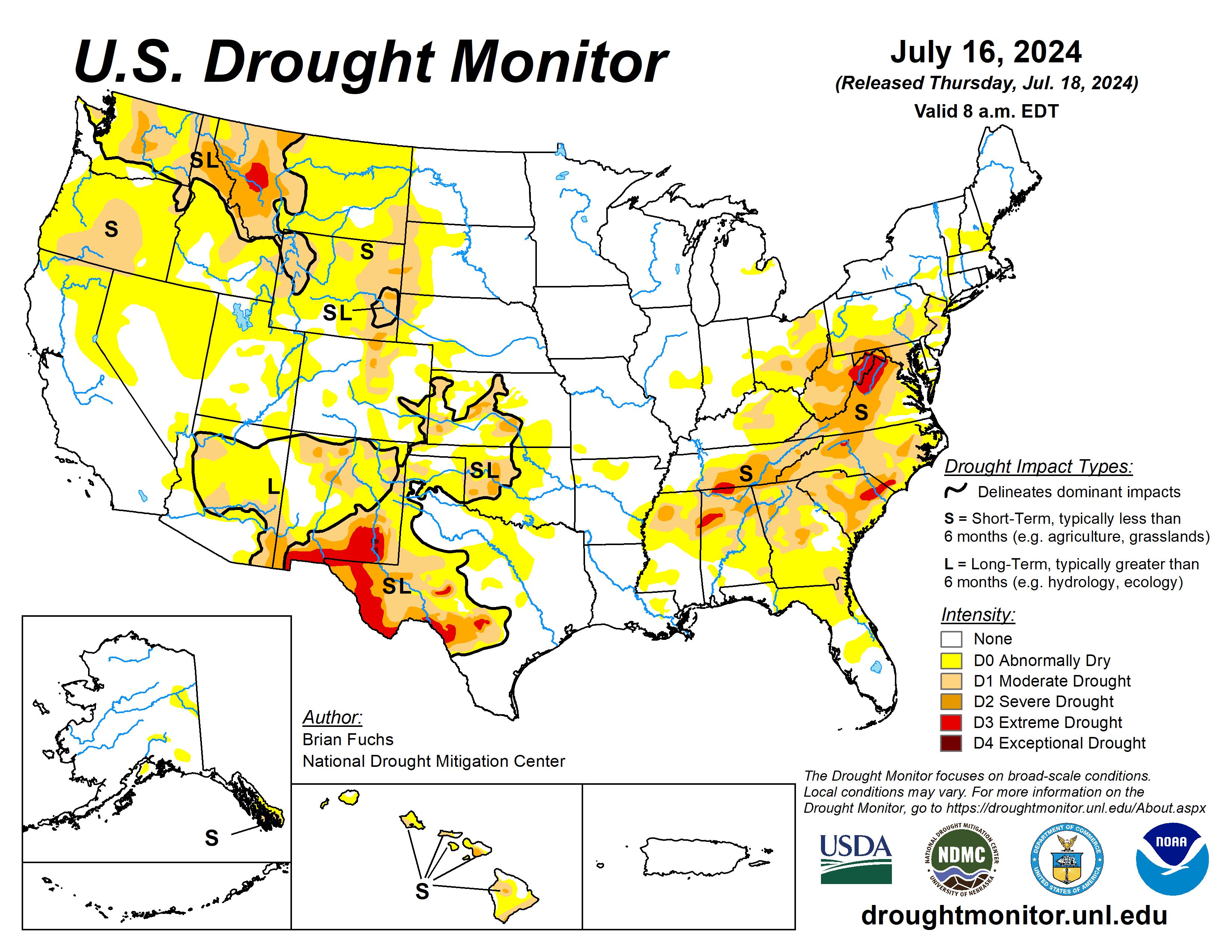
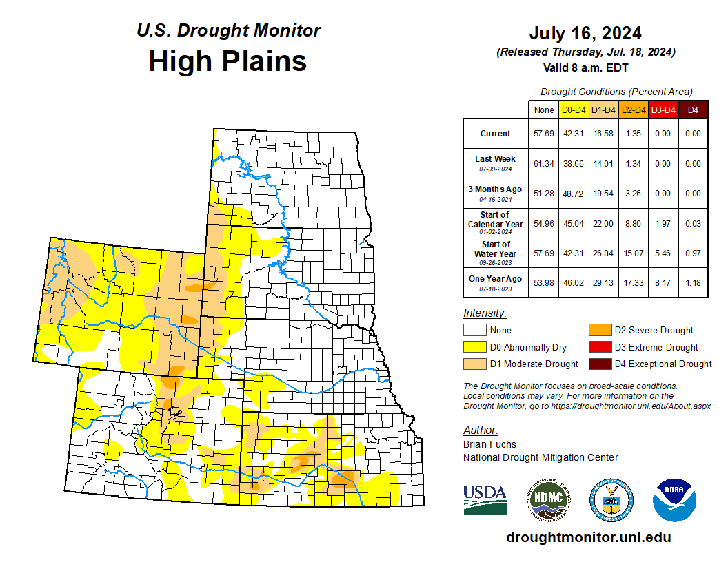
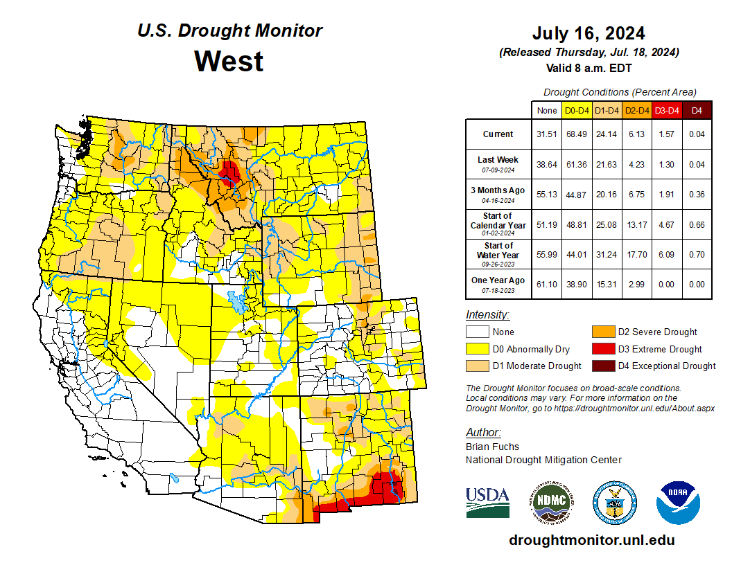
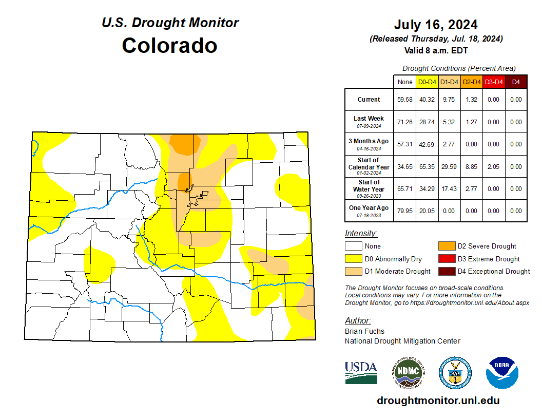
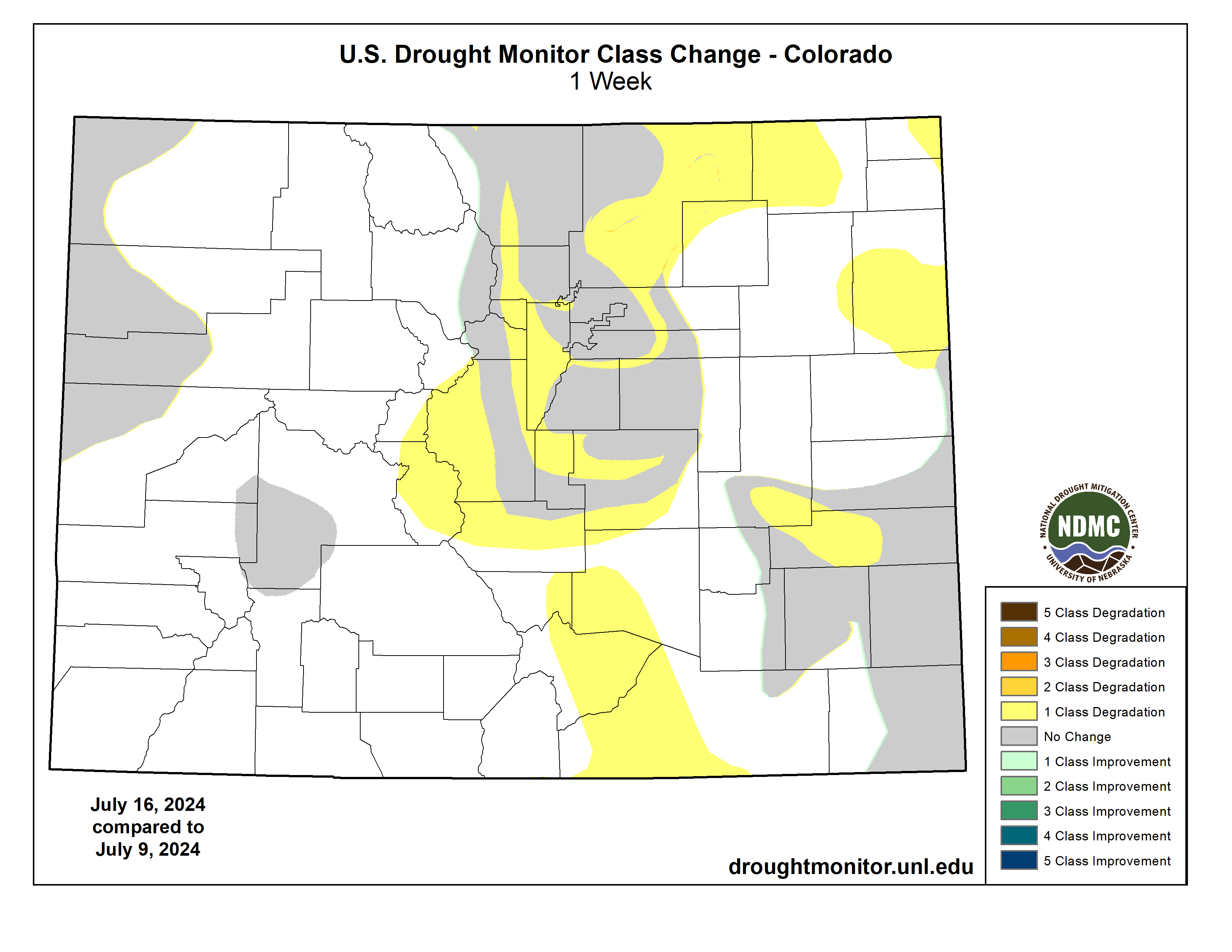
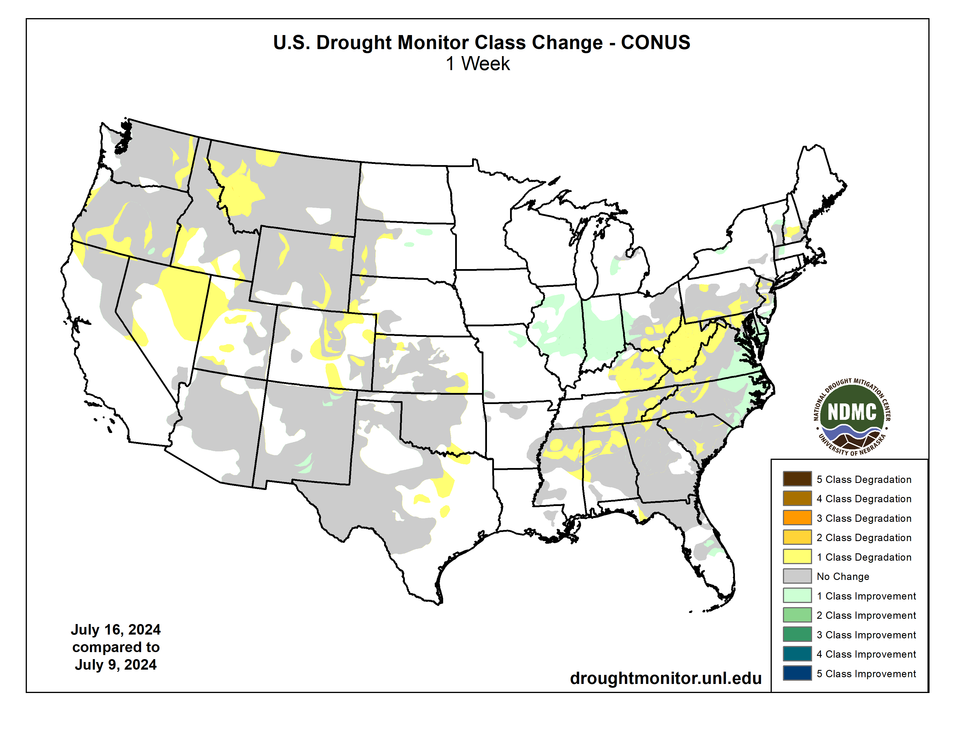


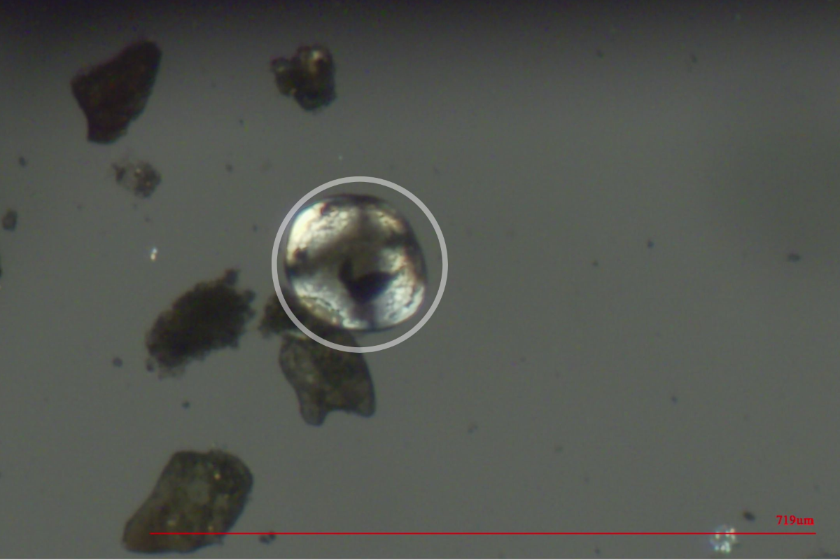
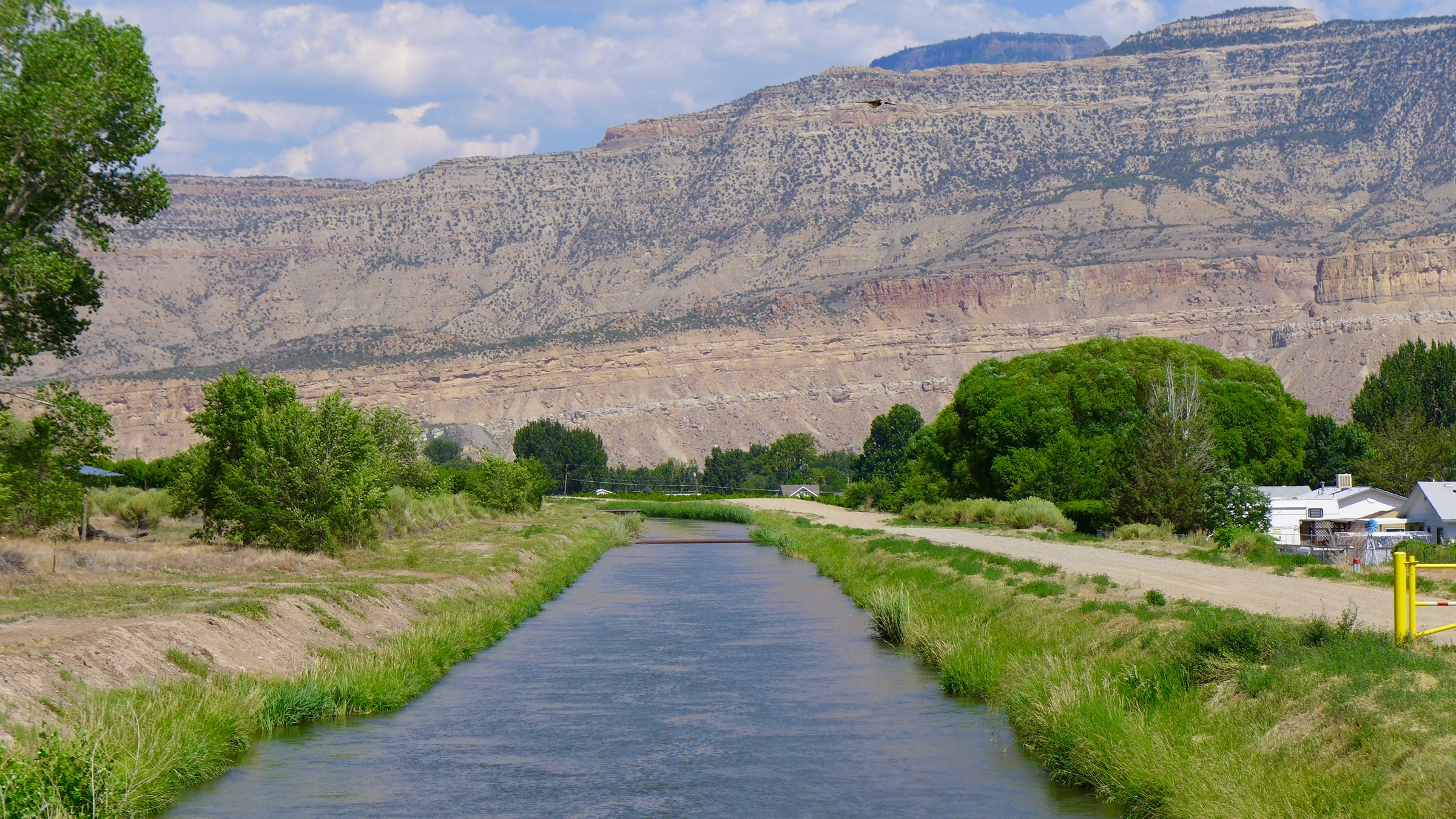
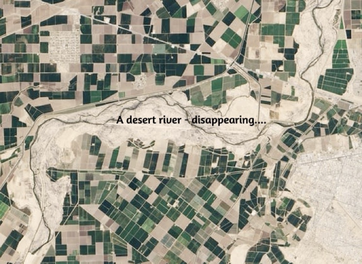

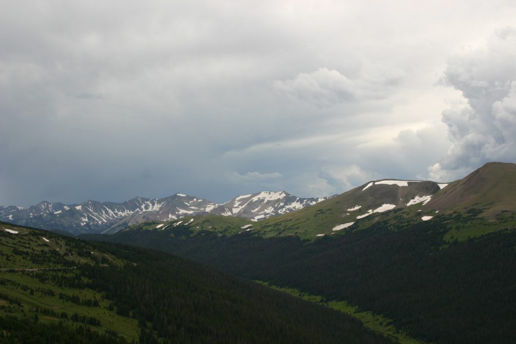
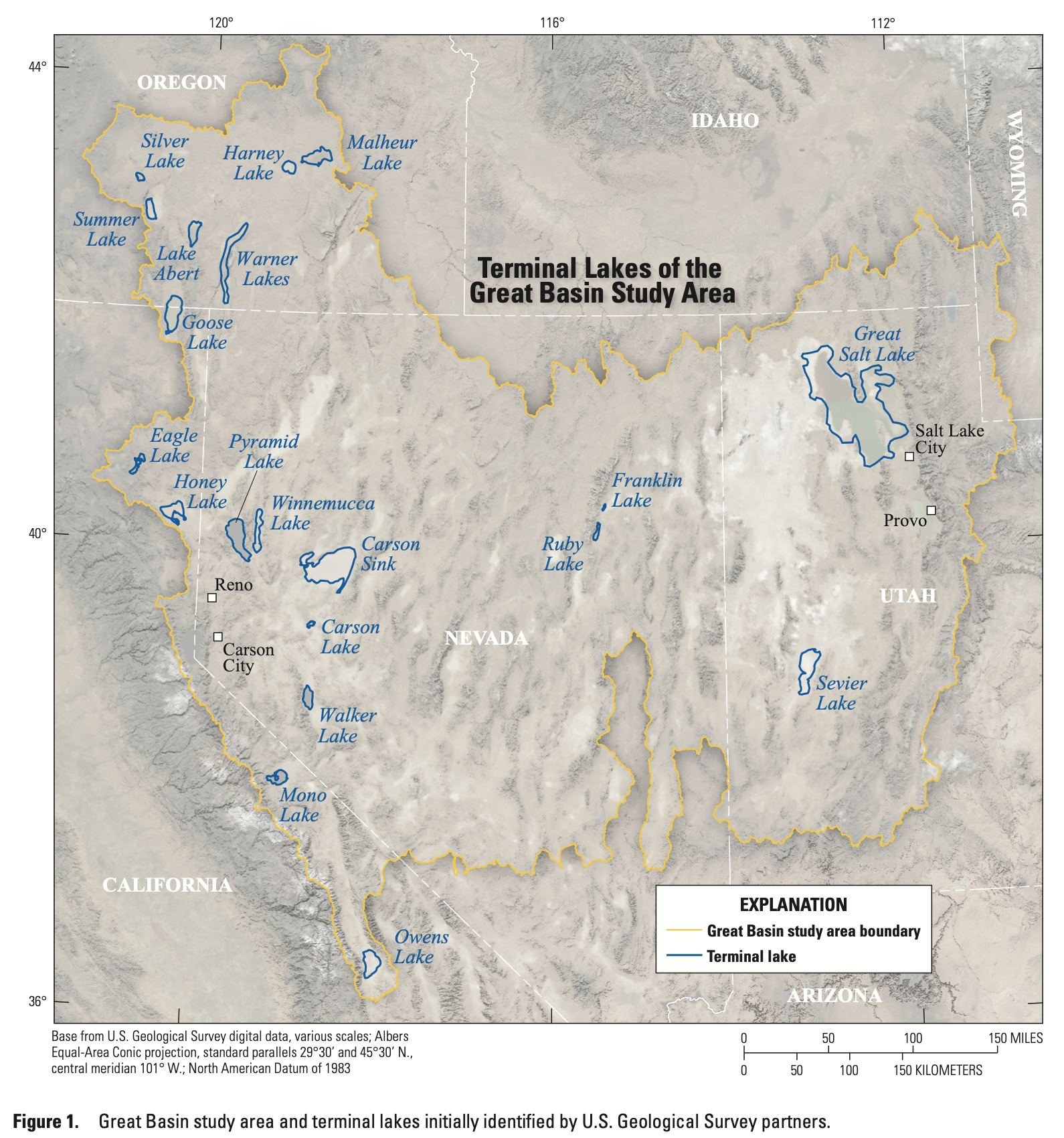
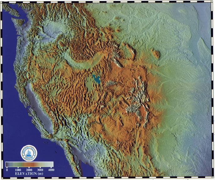


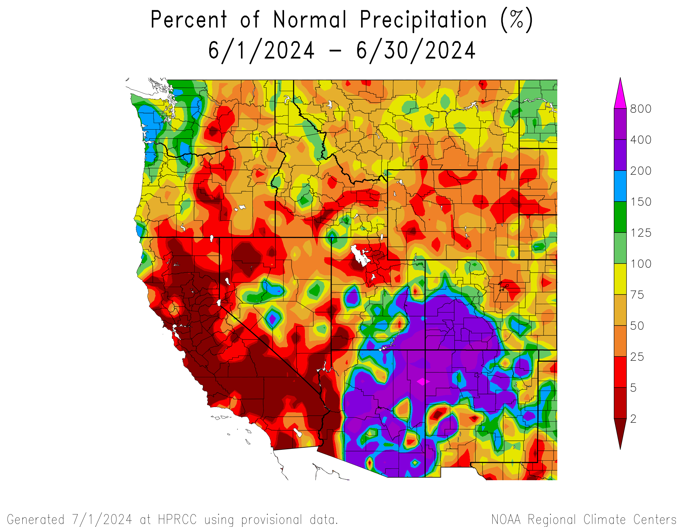
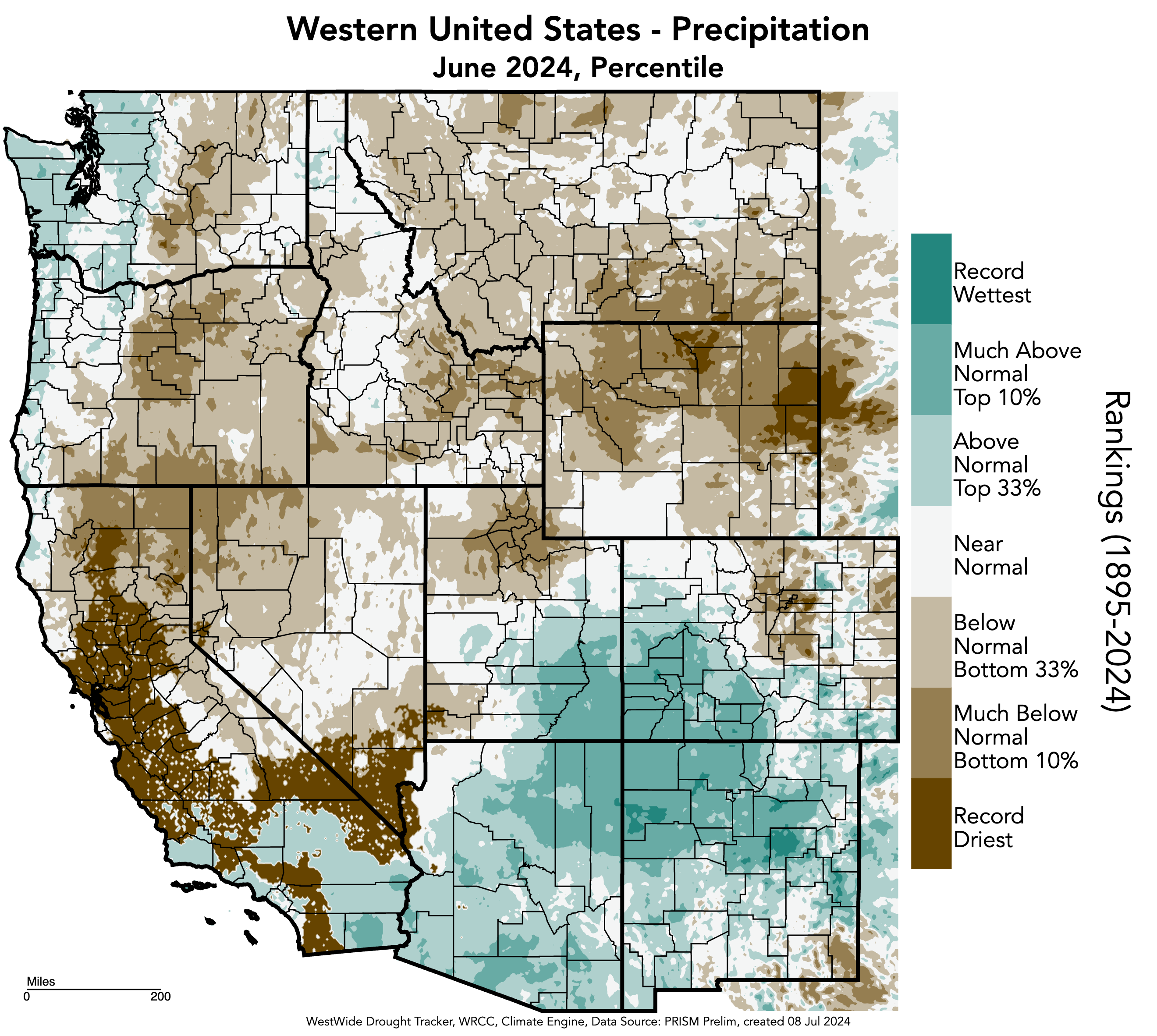
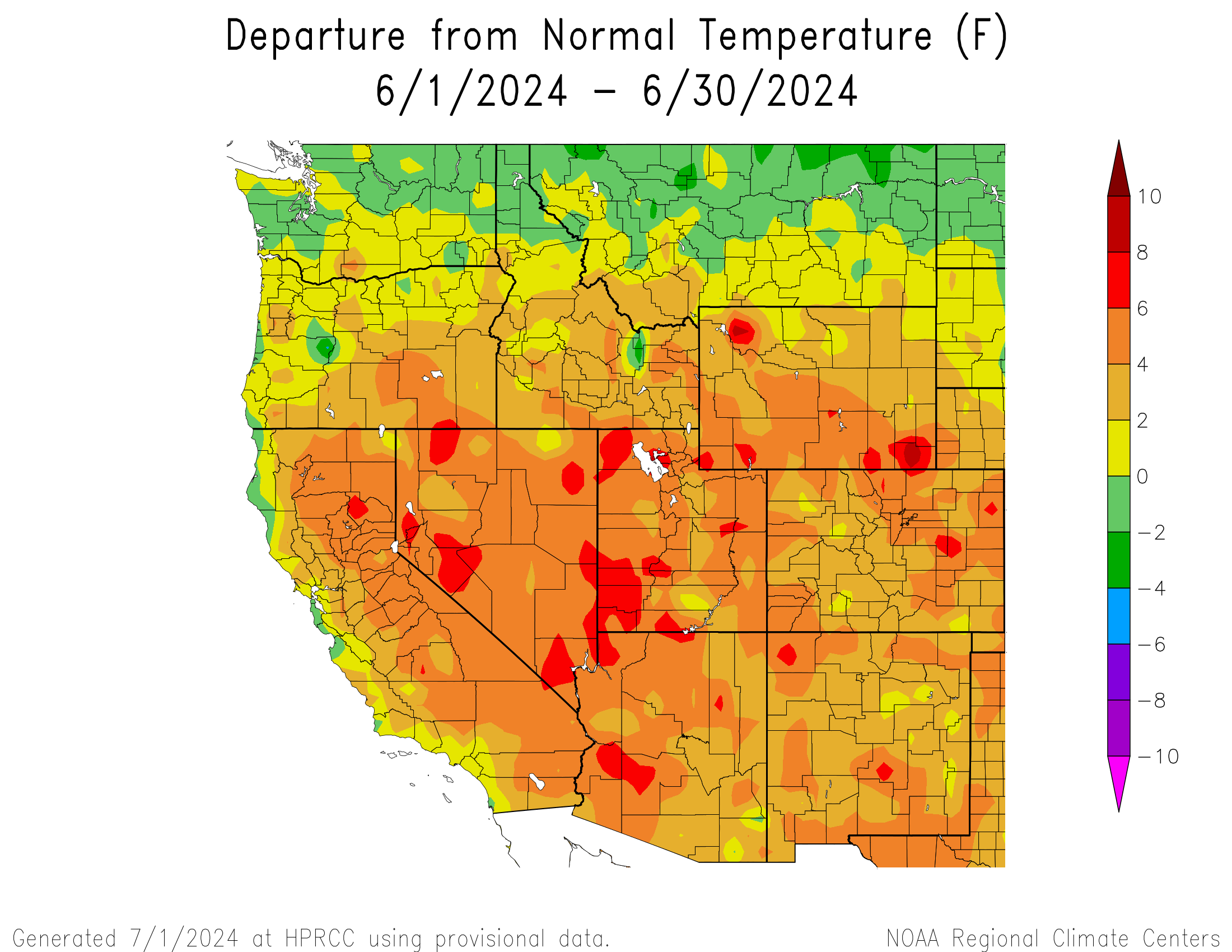
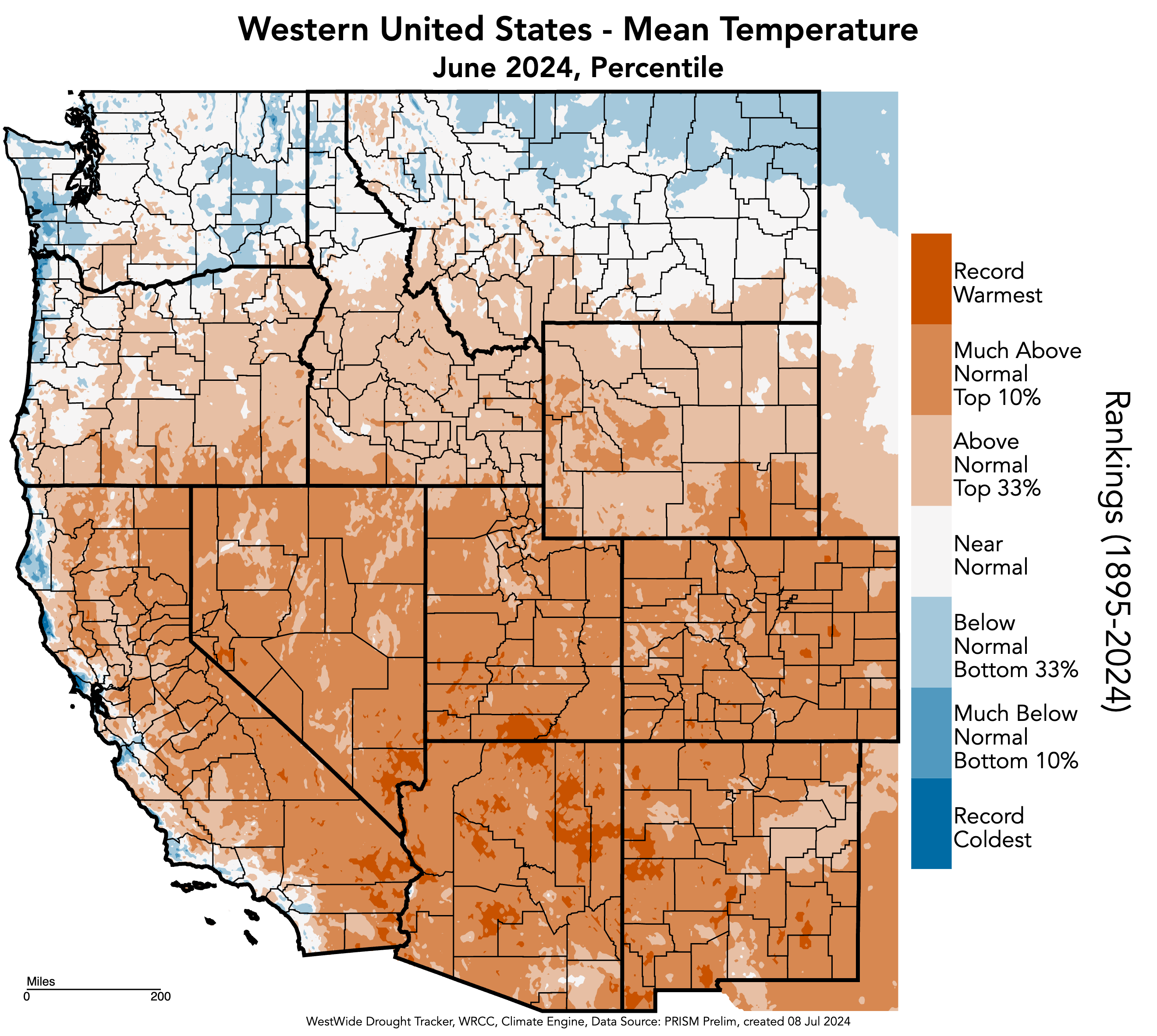
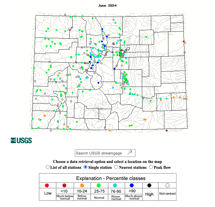
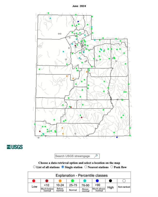
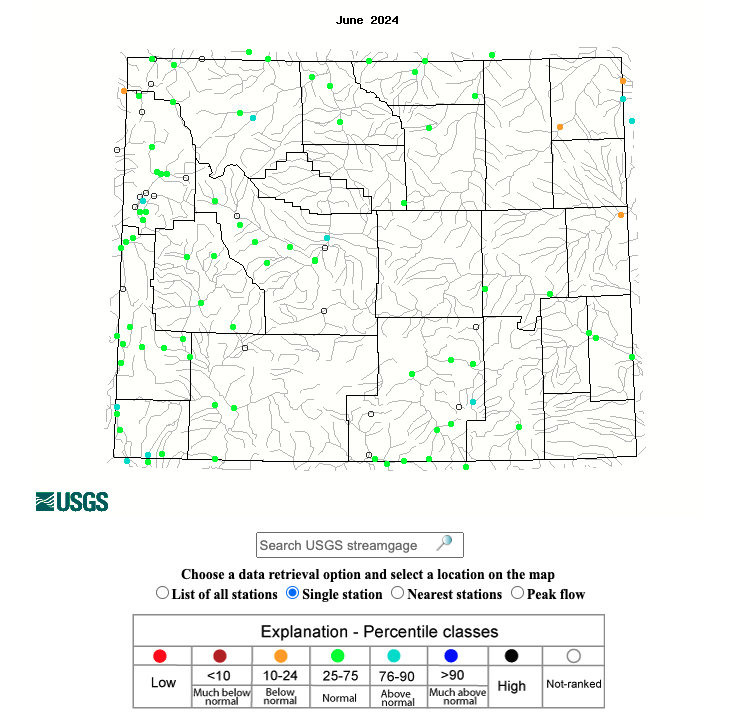
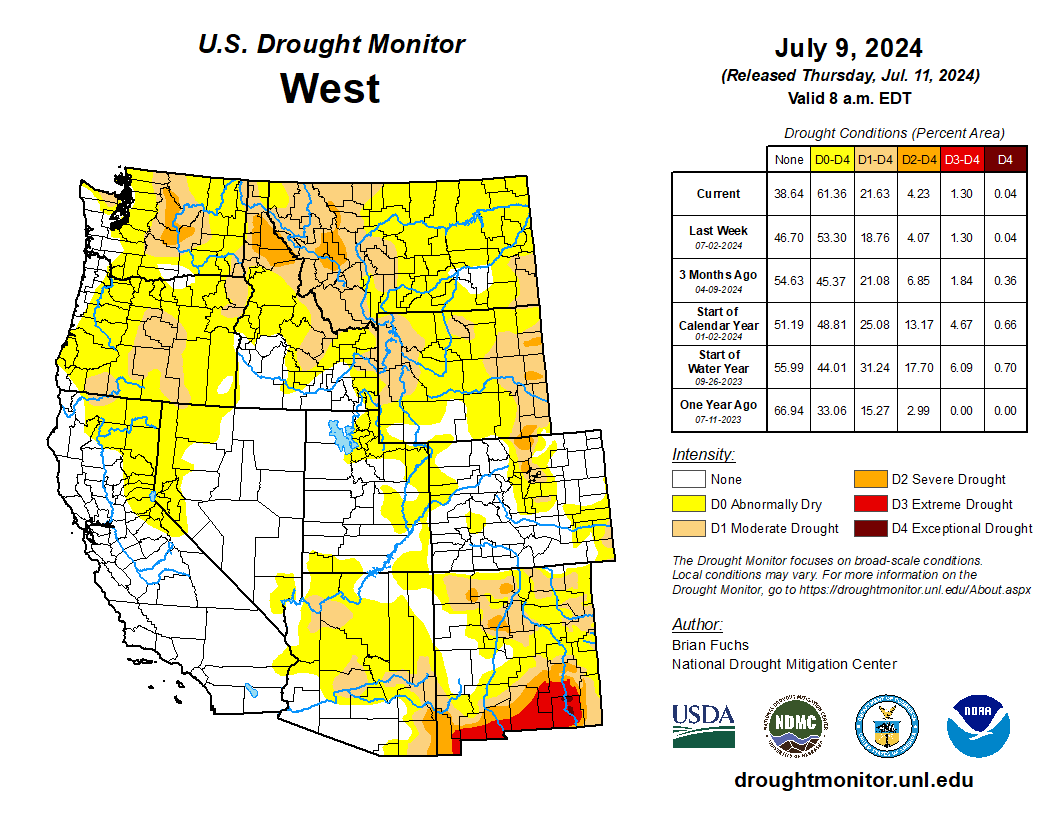
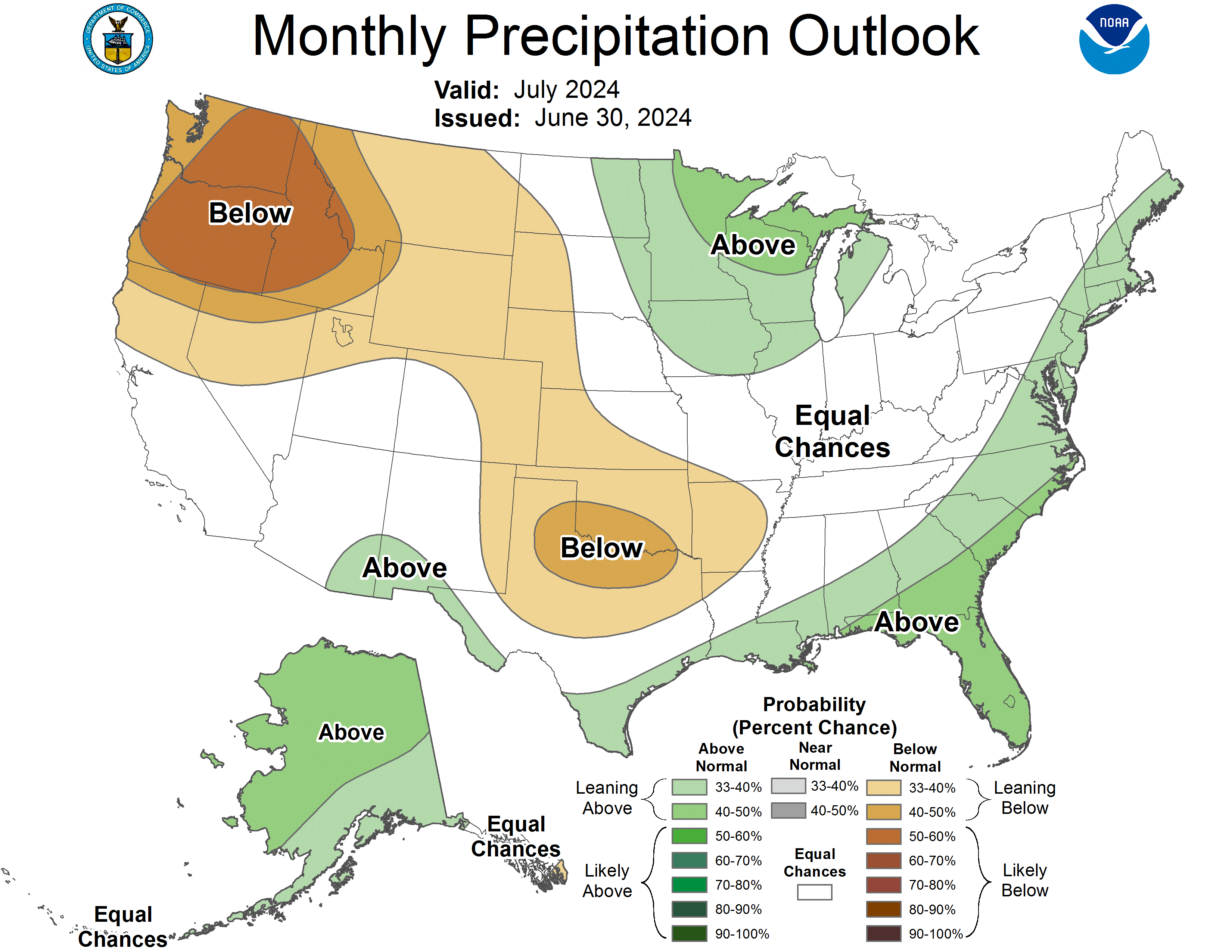
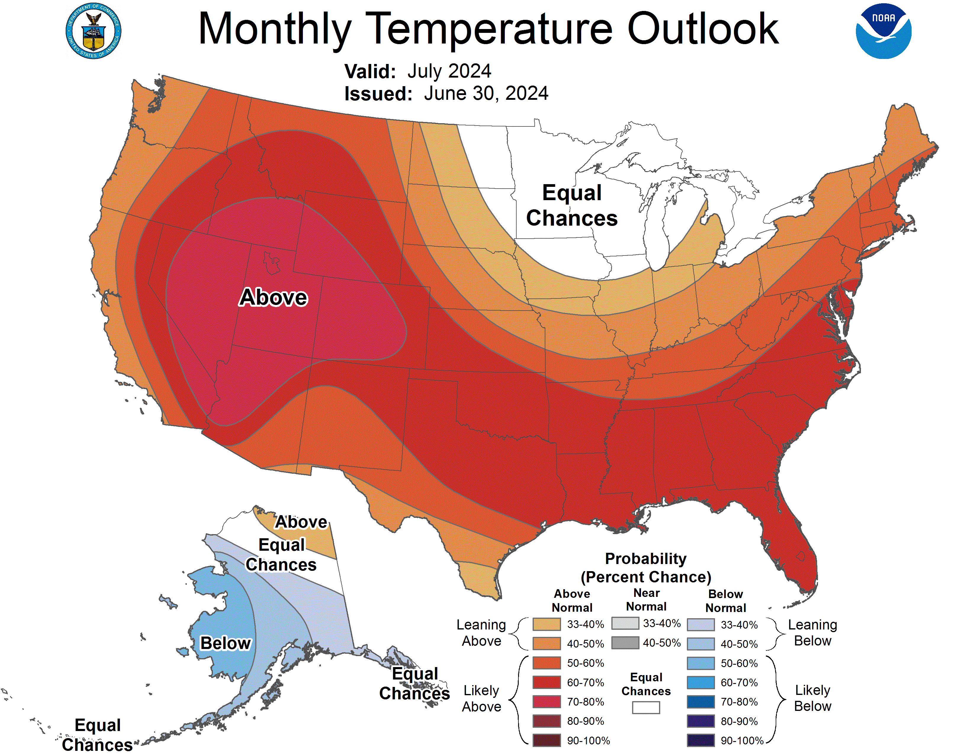
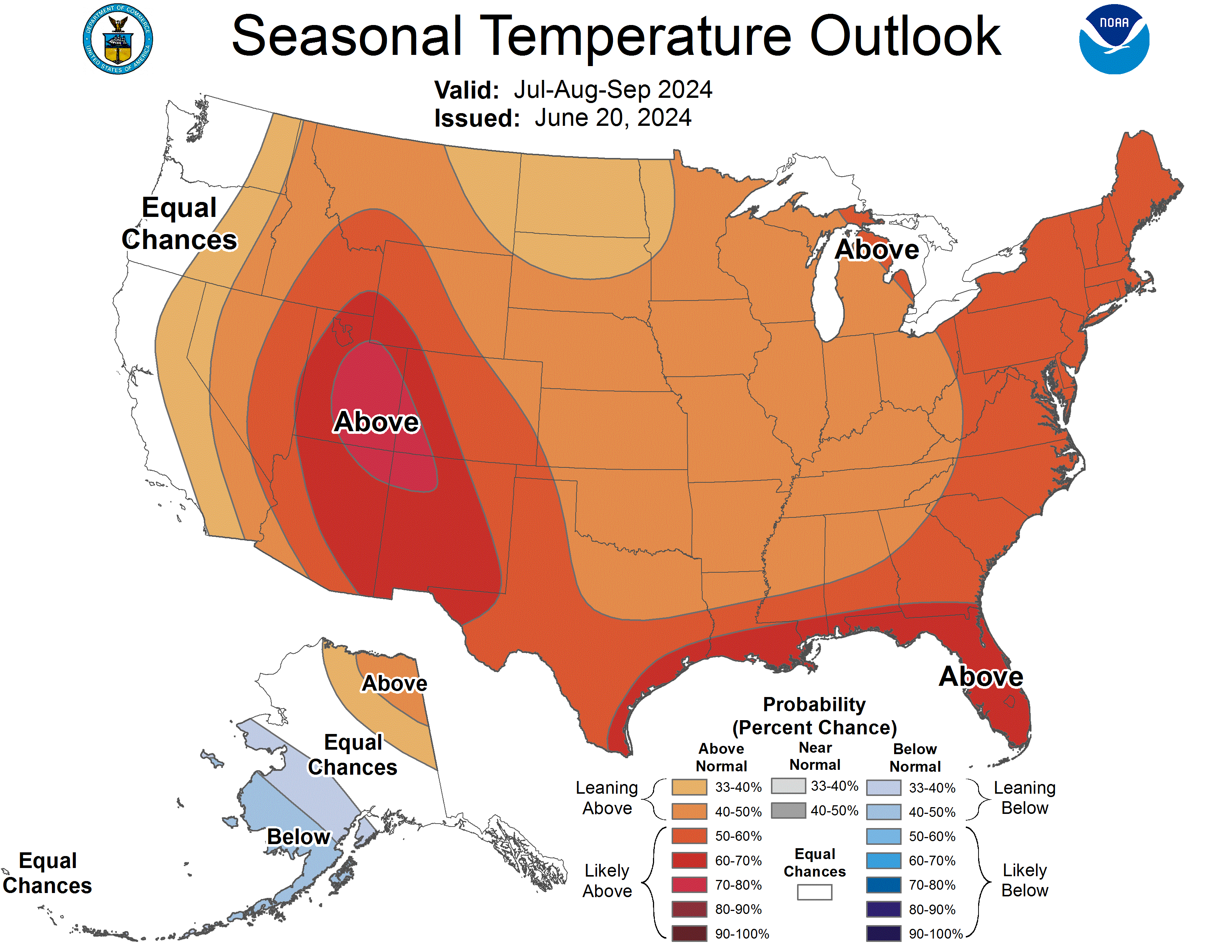
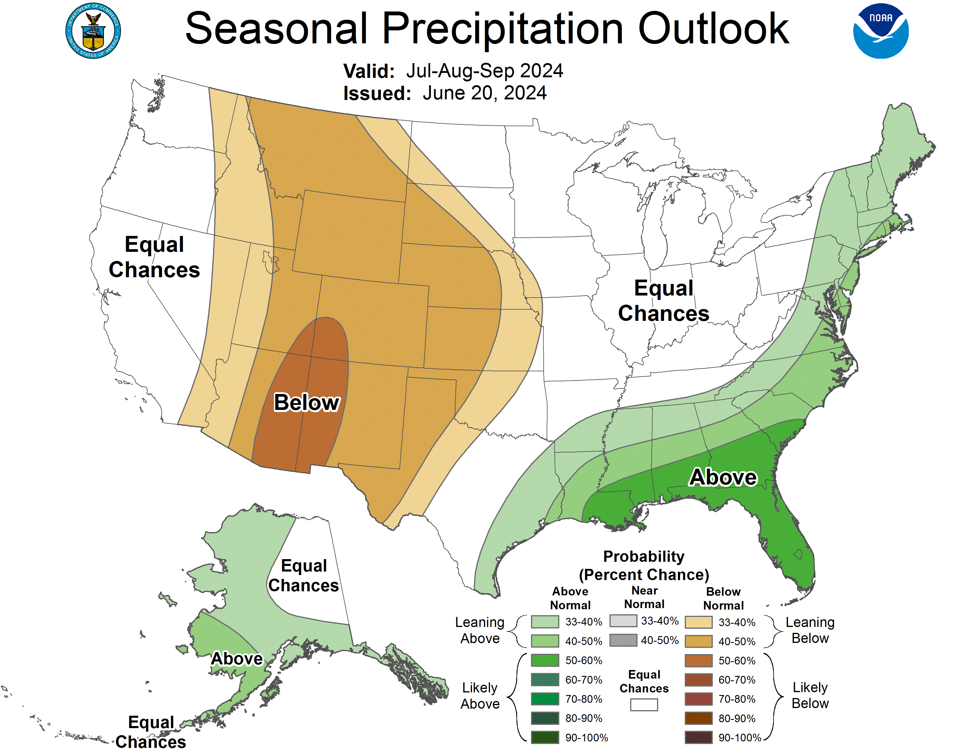
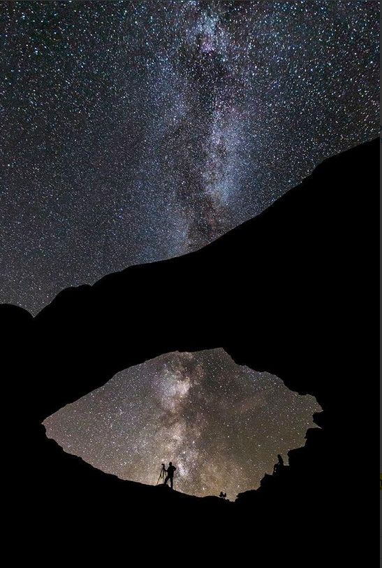
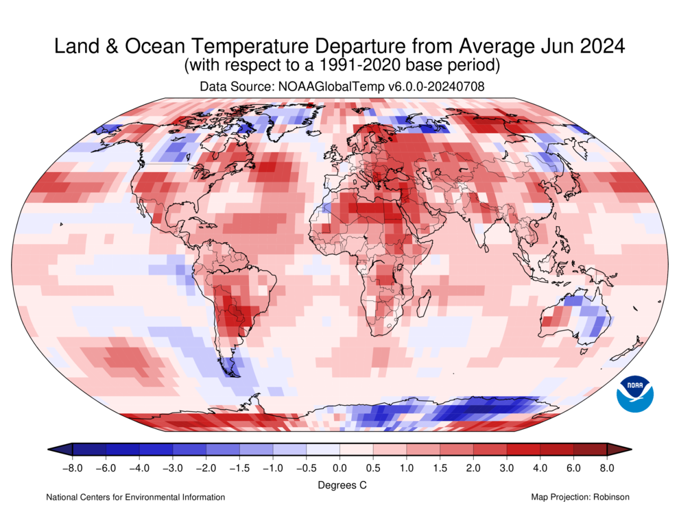
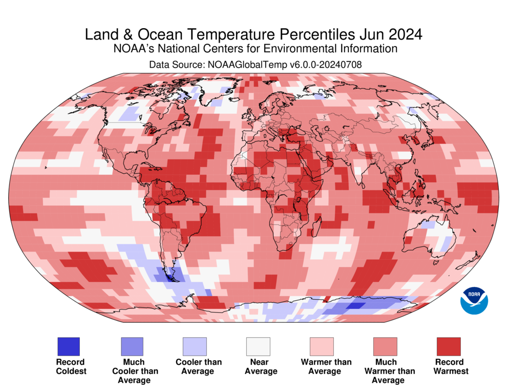
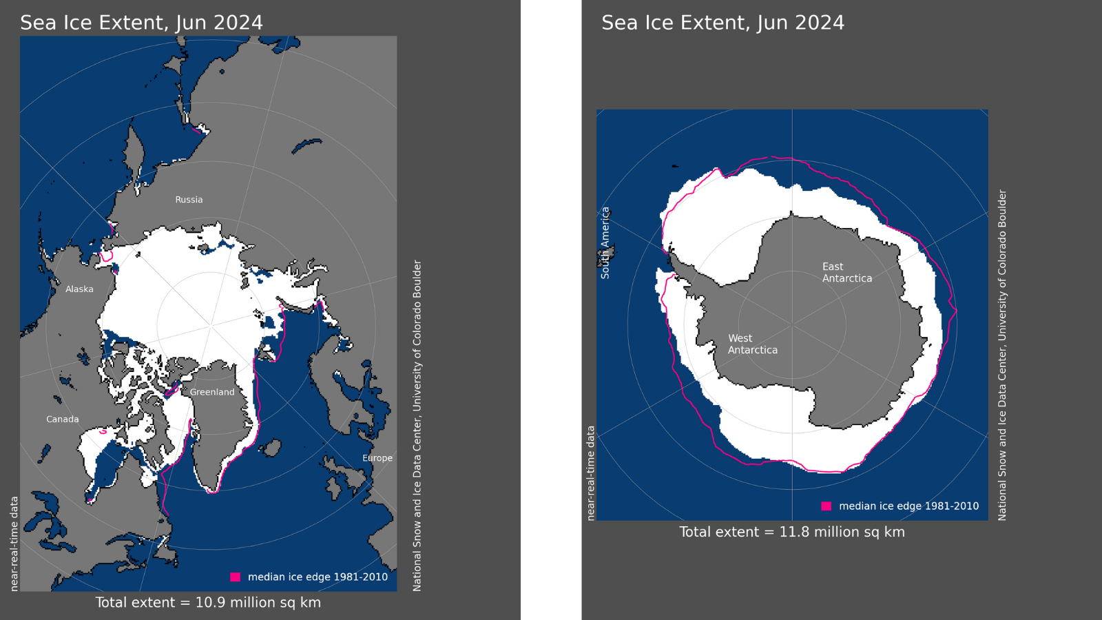
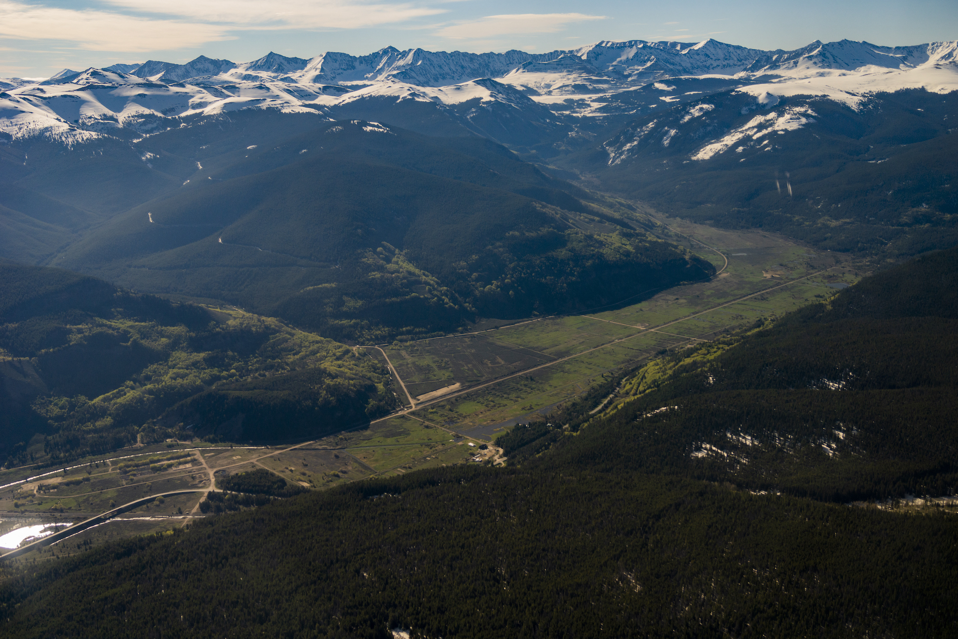
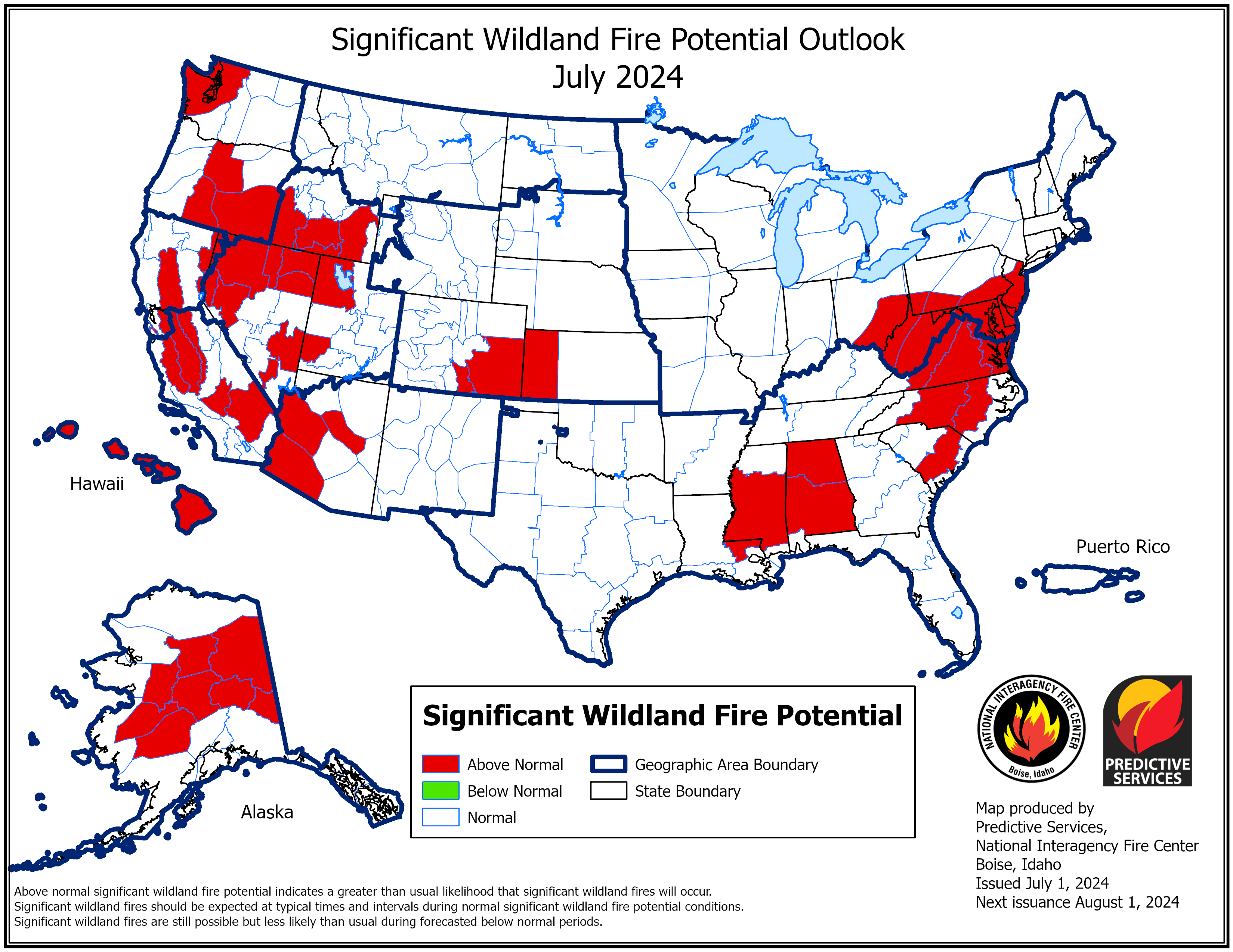
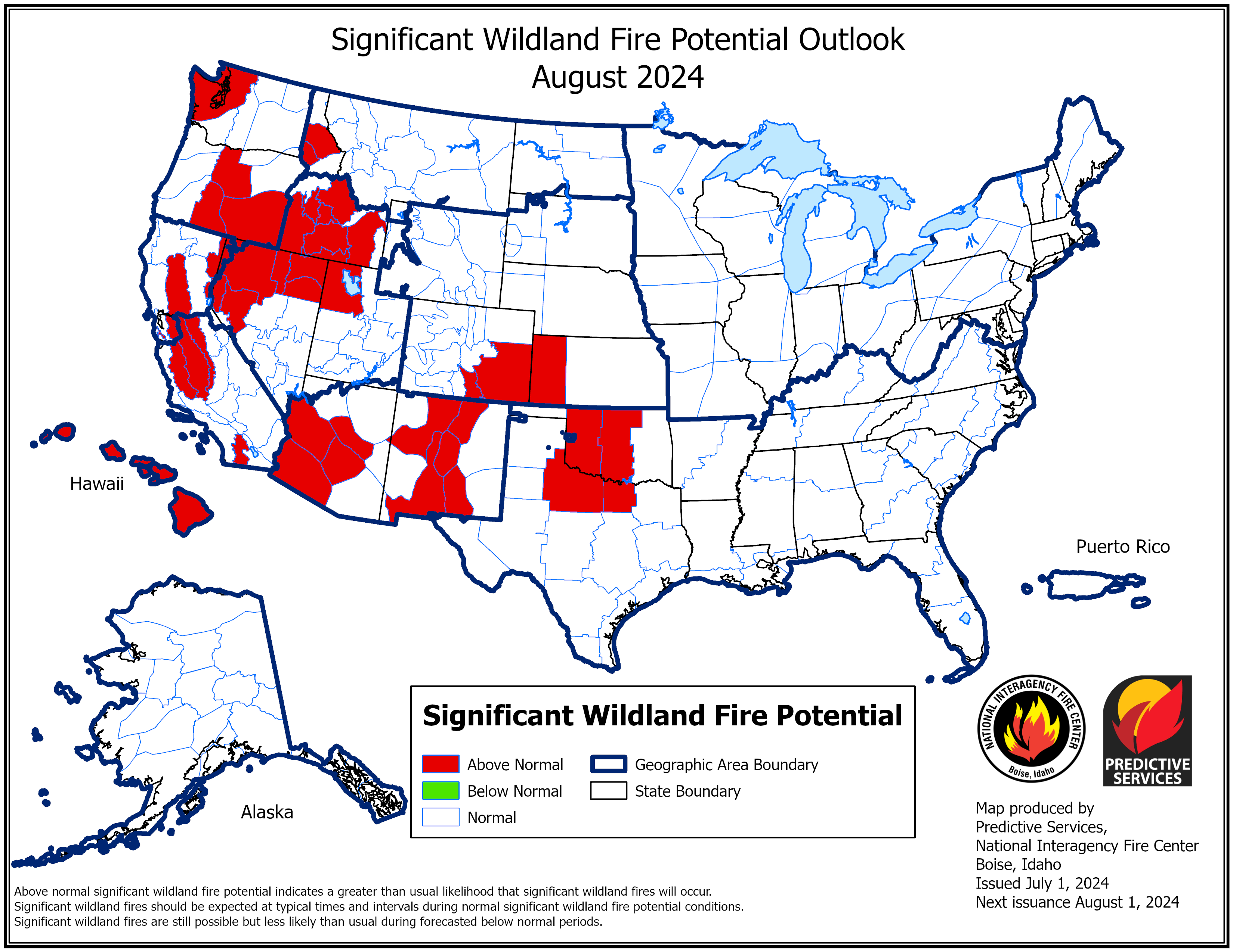
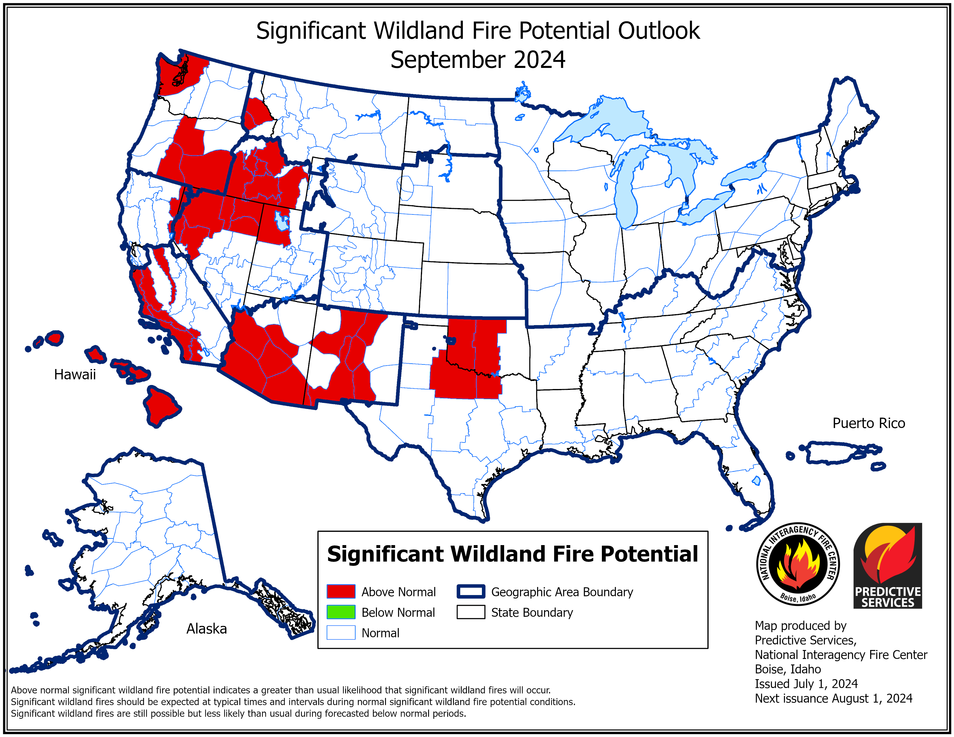


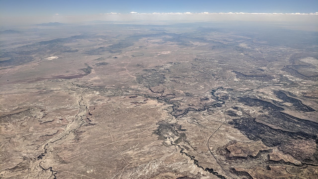


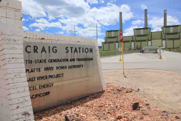
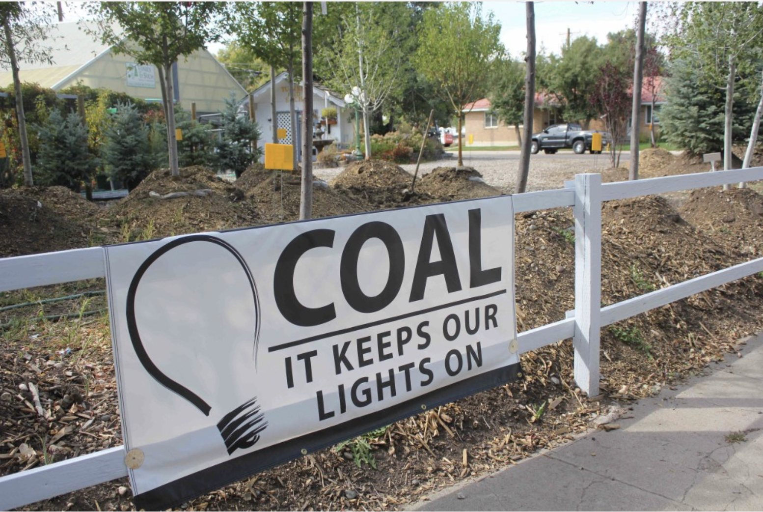
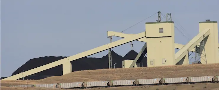
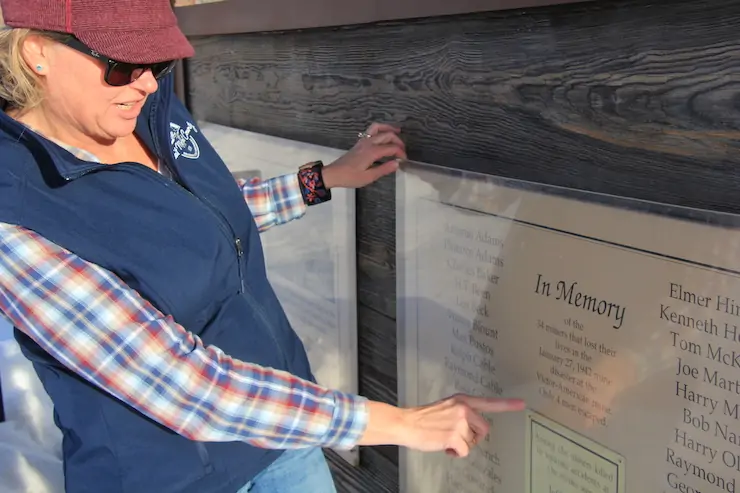


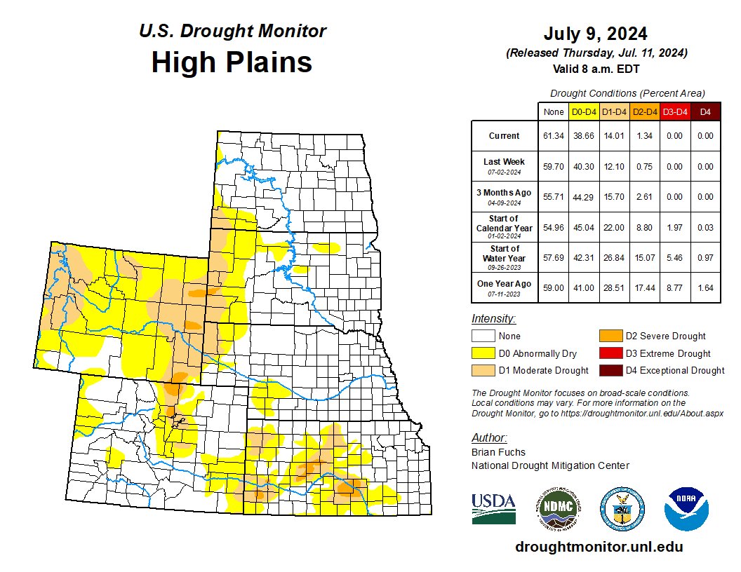
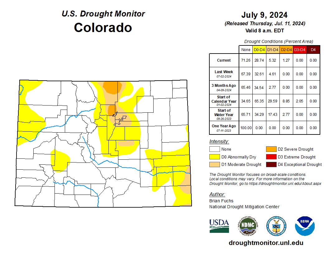

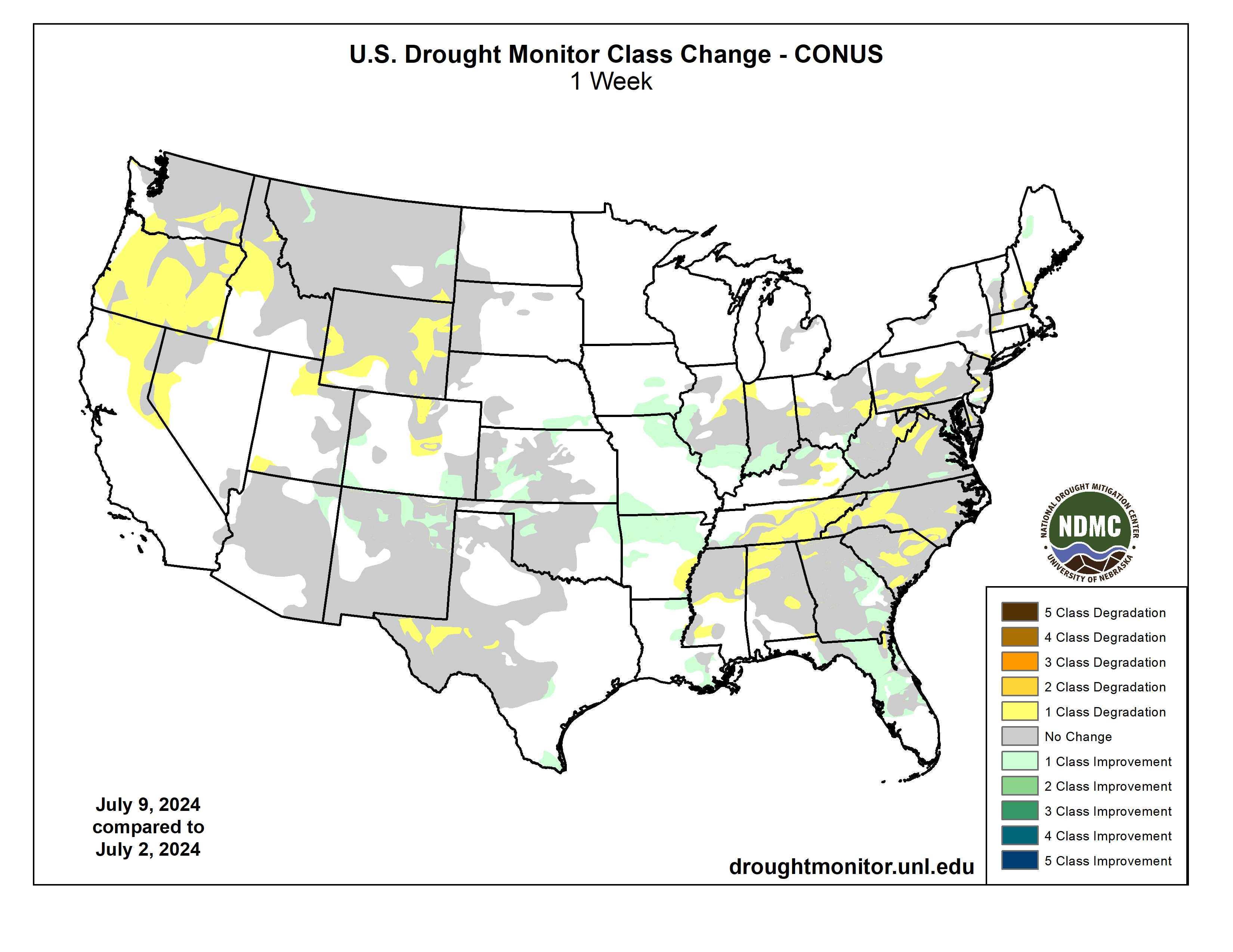


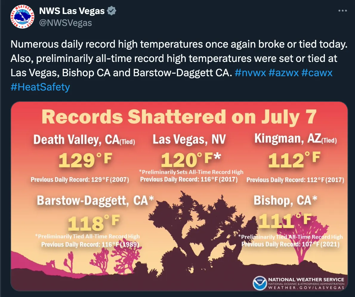

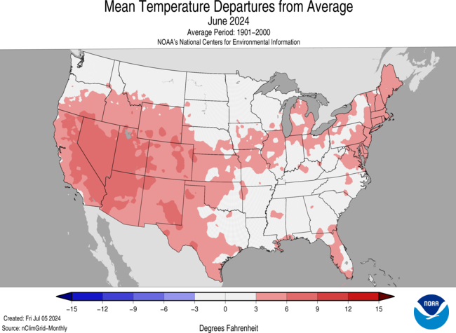
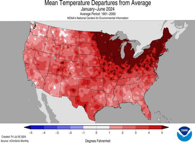

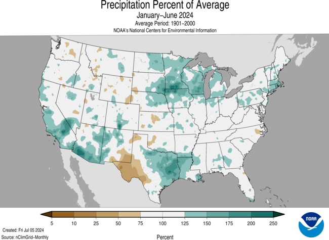
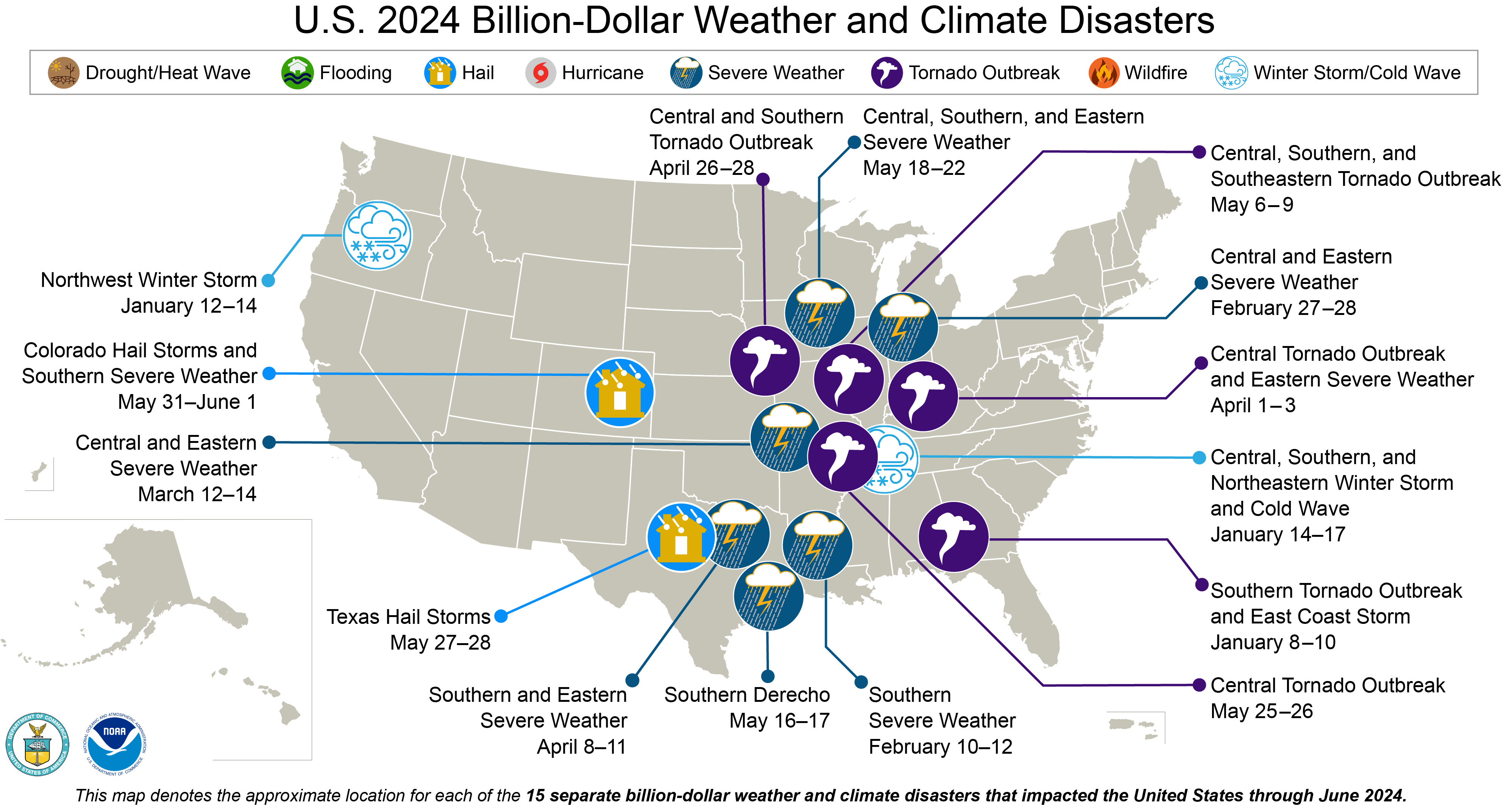
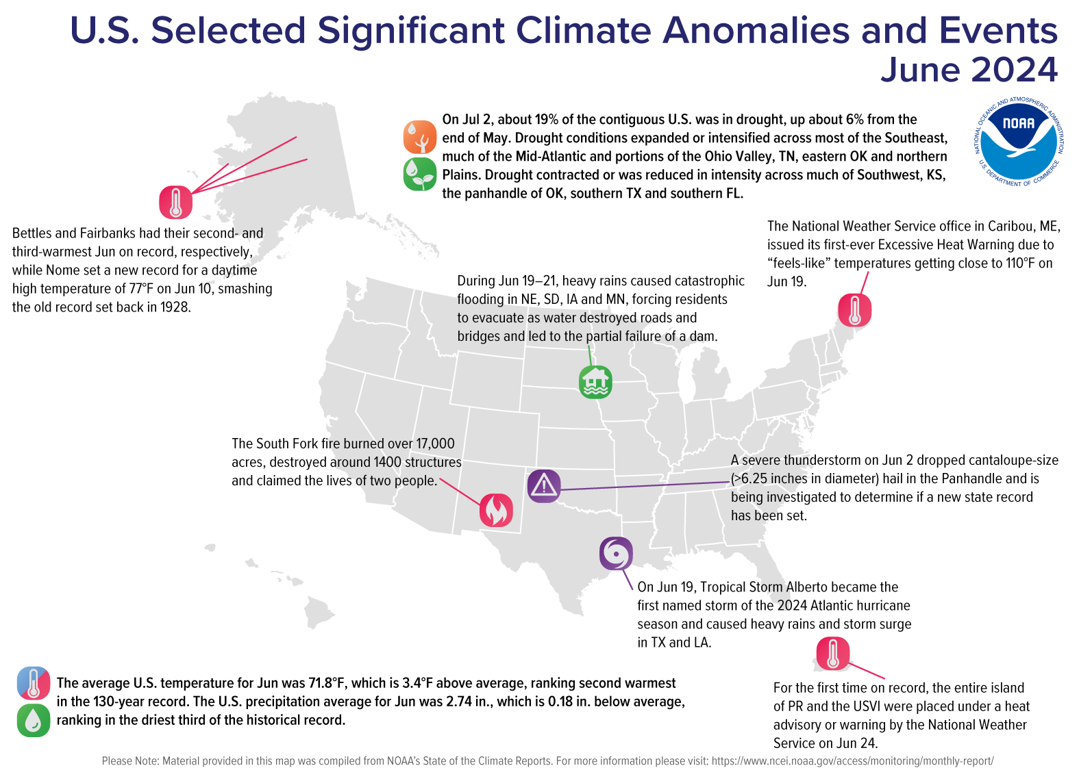
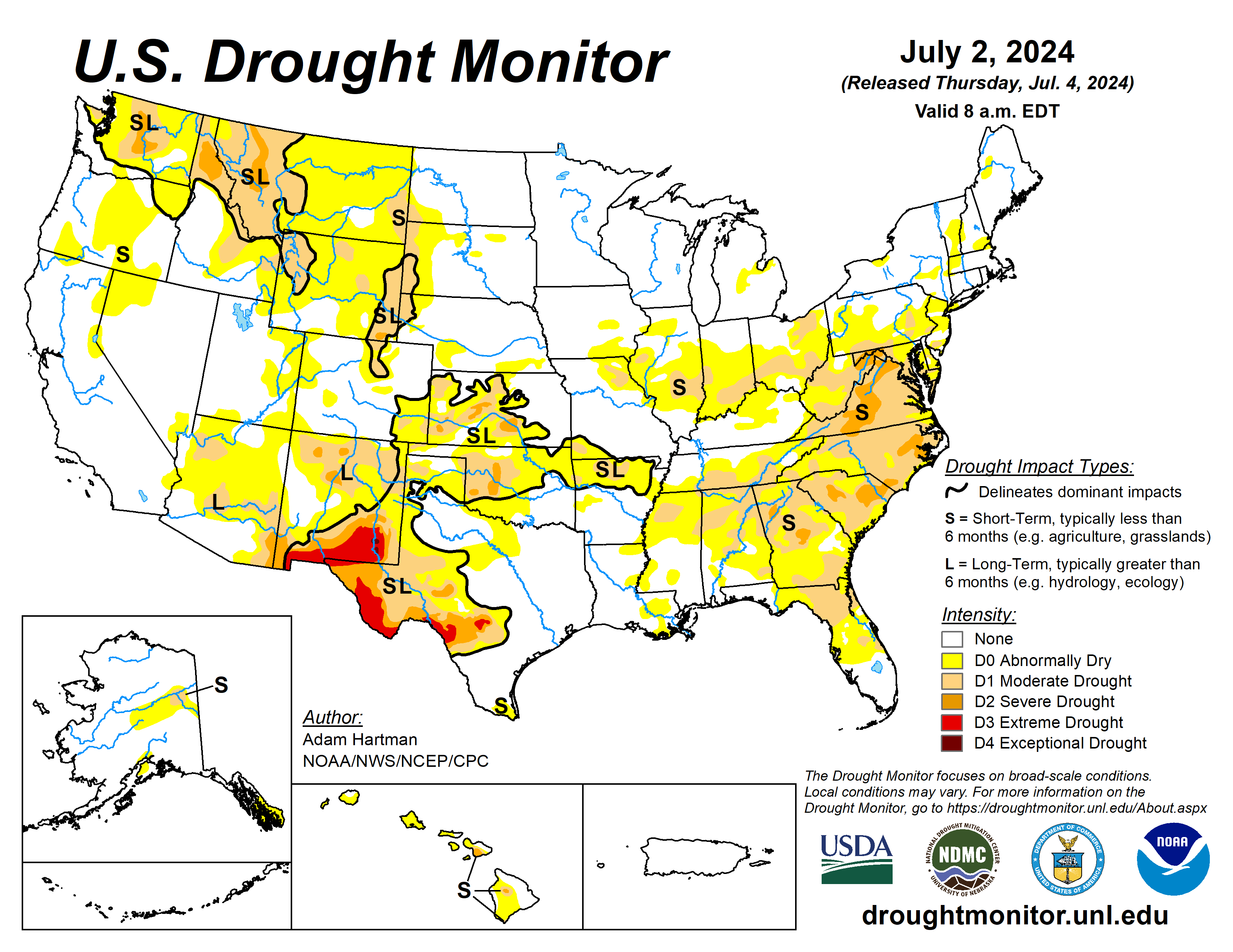


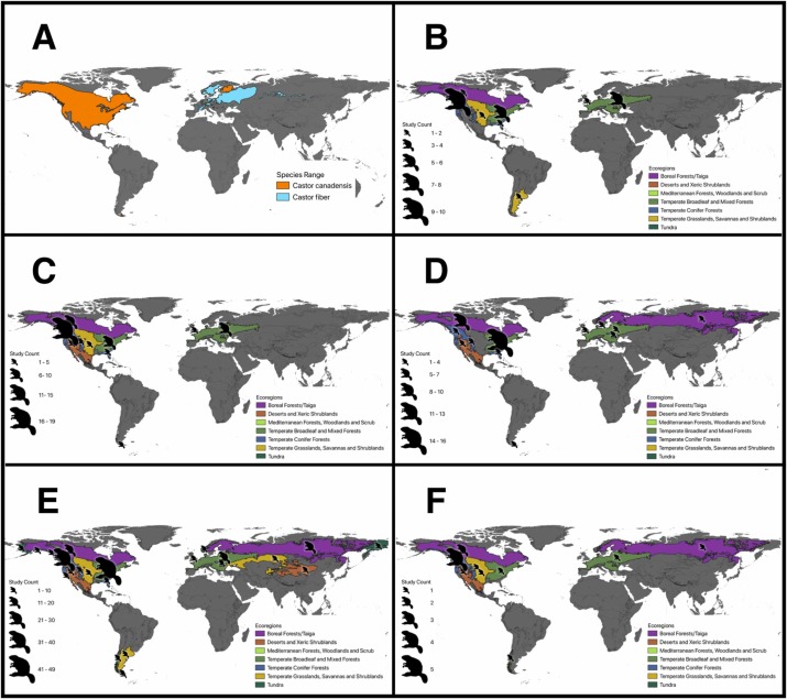


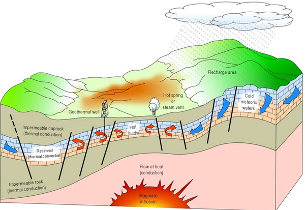


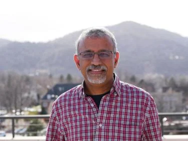
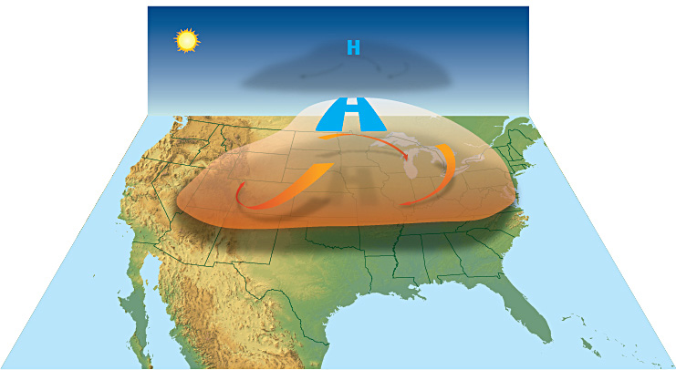


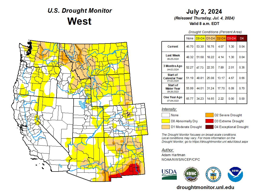
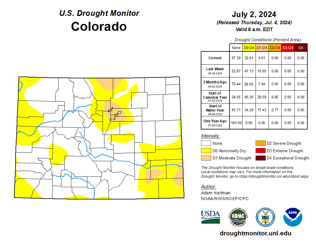
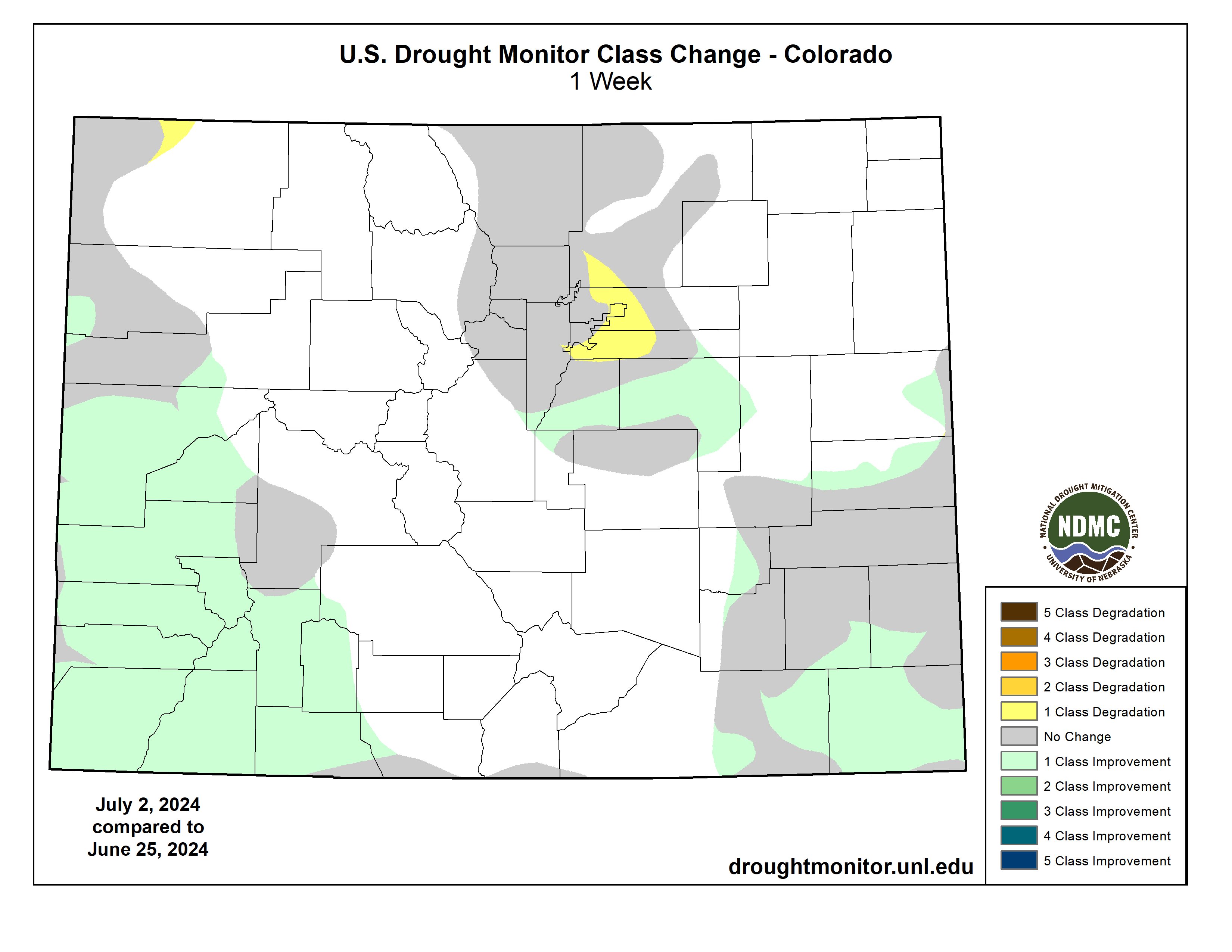
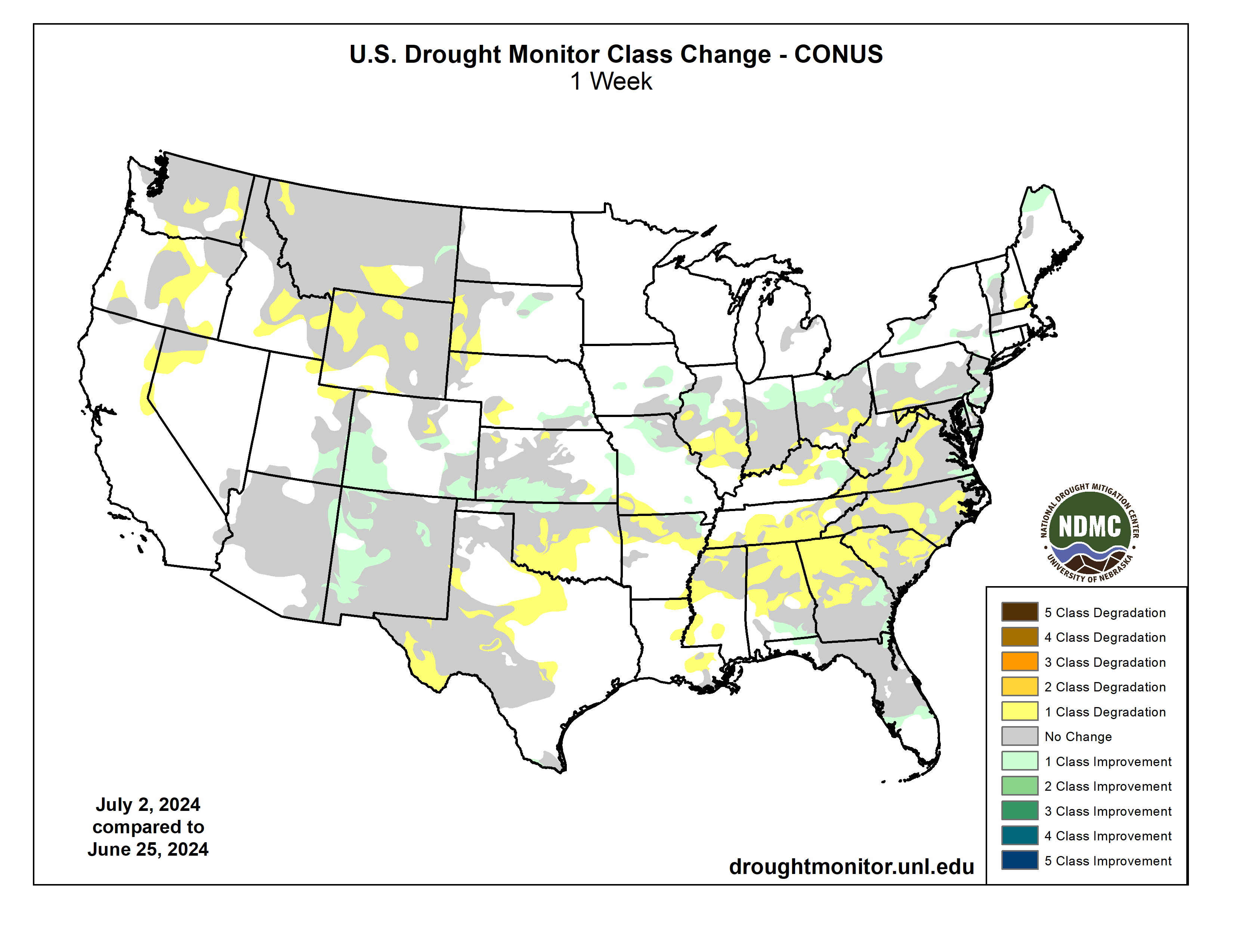

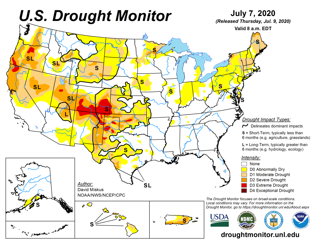
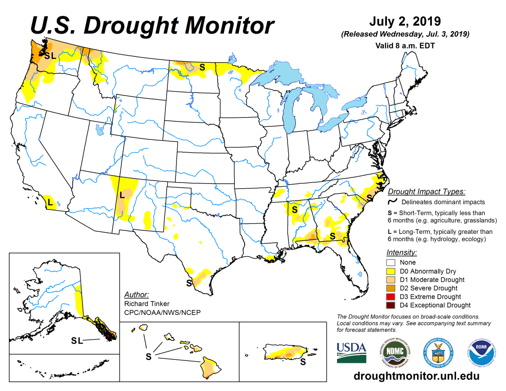
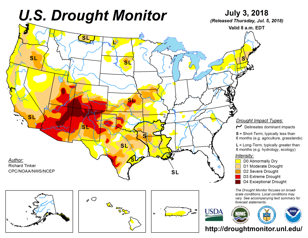

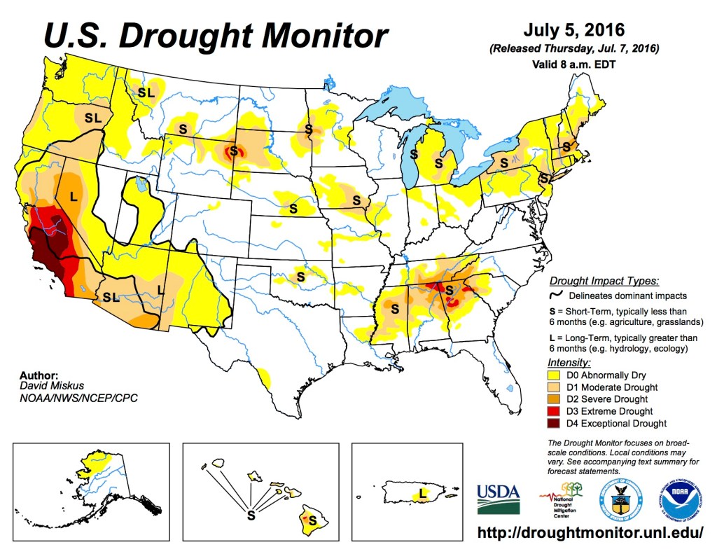
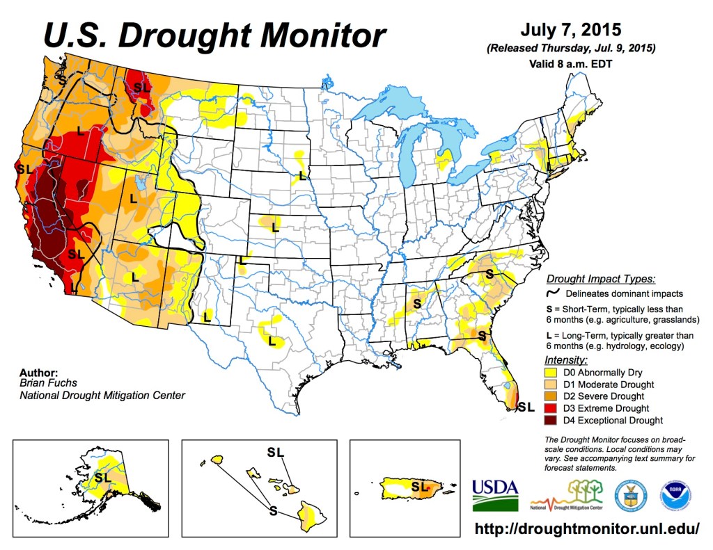
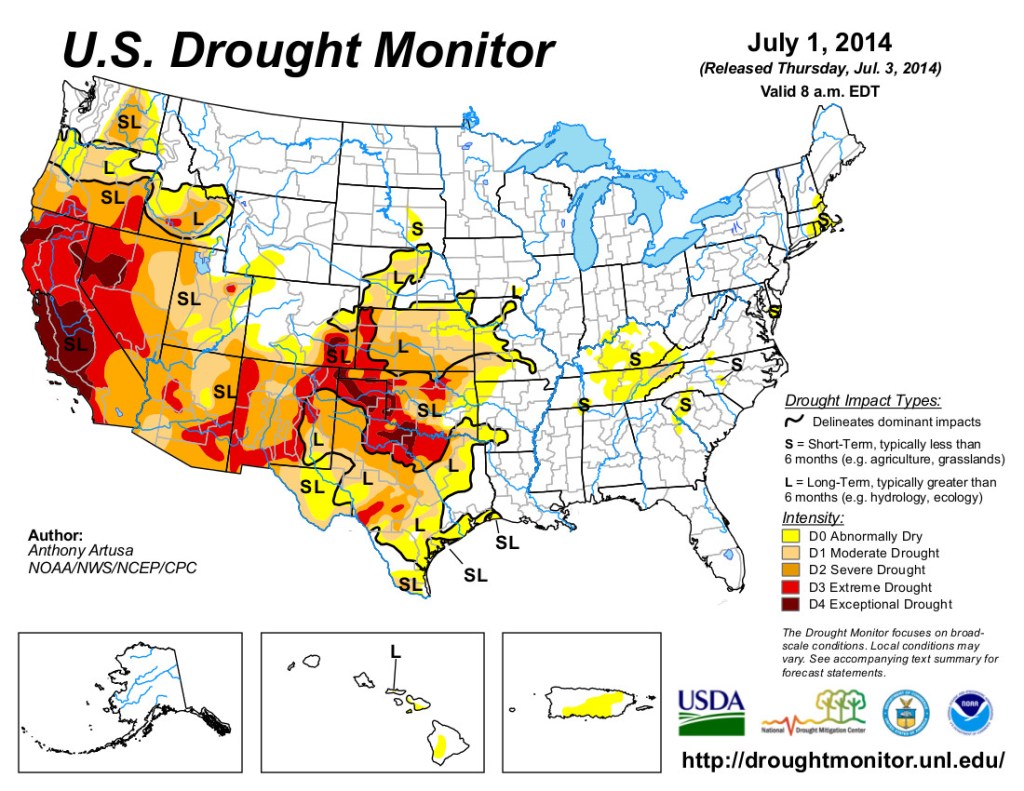
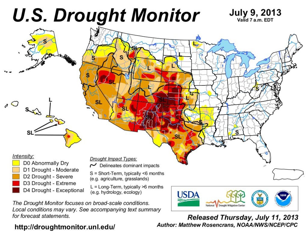
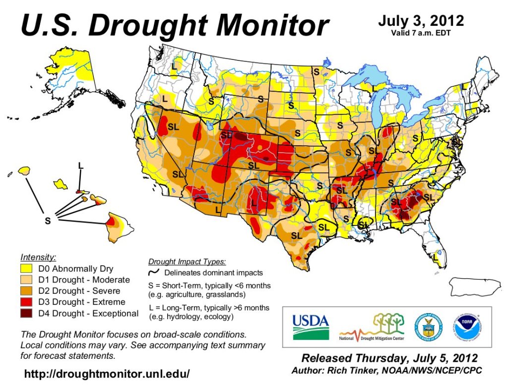
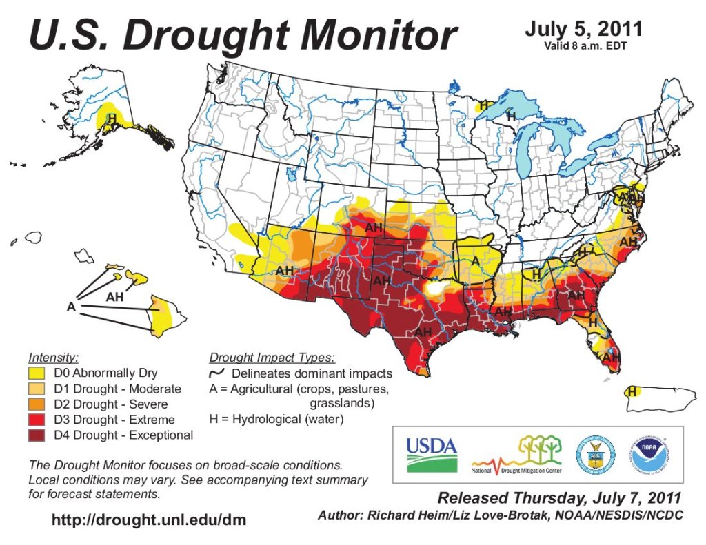

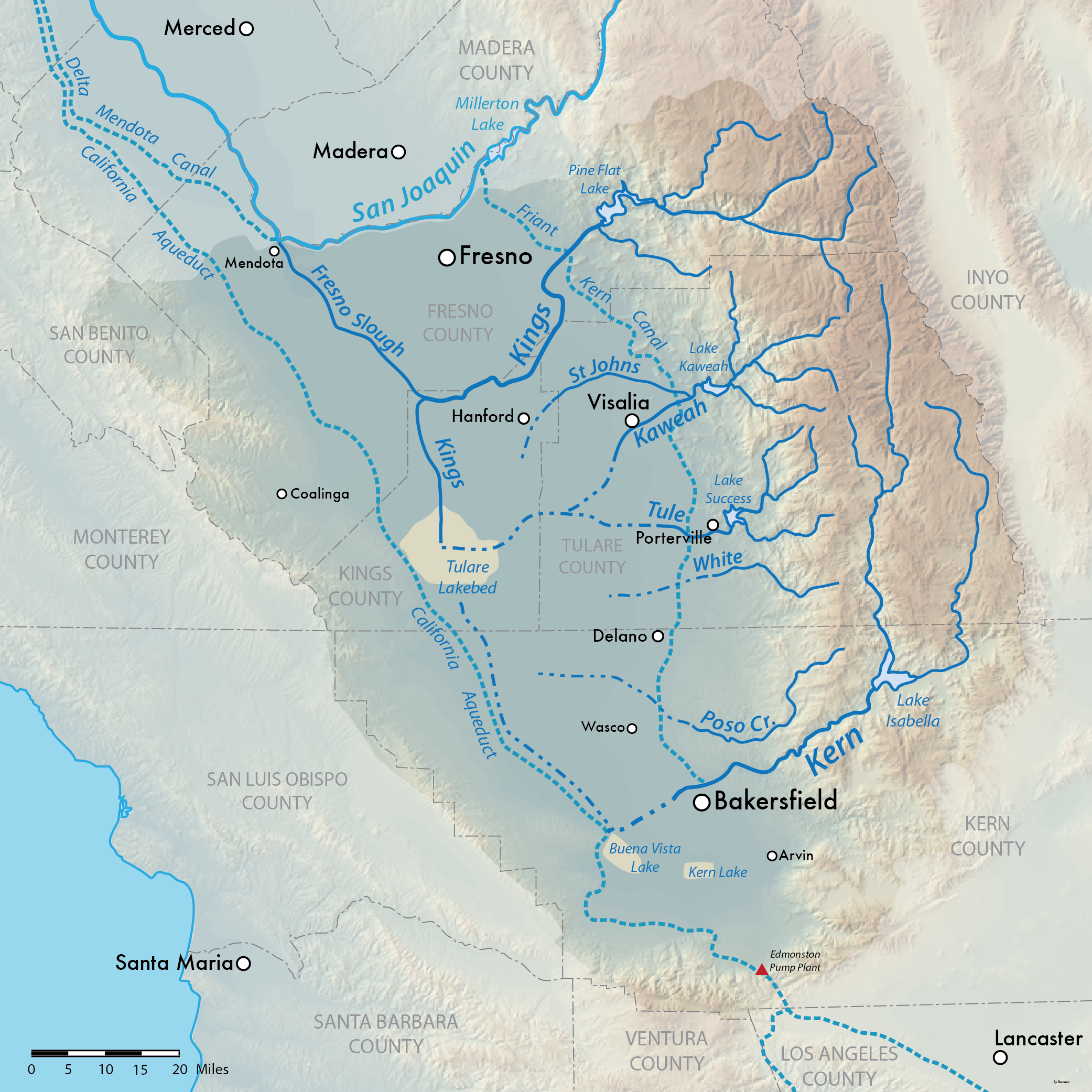