Fort Collins had a very dry and warm December 2023
The city received no measurable snowfall in December, which is the first time that happened since 2002. Before 2002, it happened only three other times, the last of which was in 1935.
The city received 0.14 inches of precipitation, which fell as rain. It was the driest December since 2018.
The average temperature was 37.3 degrees, which was the warmest for December since 1980.
December reached above 60 degrees five times, including the high of 65 degrees on Dec. 6 and the last balmy day of 62 degrees on Dec. 21.
It never got colder than 15 degrees. That happened on Christmas night and was the highest minimum temperature for the month since the beginning of city weather record-keeping in 1889. Compare that to December 2022, when we dropped to minus 17 degrees, the coldest temperature recorded of any month since the 1990s.
Despite a dry December, 2023 was a wet one for Fort Collins
2023 was the fourth-wettest year on record, ending with 24.36 inches of precipitation, which was 153% of our 1991-2020 normal of 15.88 inches.
The last wetter year was in 1997, the year of the Spring Creek Flood, when we received 25.23 inches.
The city’s record for precipitation in a calendar year is 28.28 inches in 1961.
Following the U.S. Supreme Court’s decision narrowing the reach of the Clean Water Act, states including Colorado must now pick up the slack to protect water the federal government no longer will.
The new definition of “waters of the United States,” or WOTUS, excludes a large number of wetlands that now require state regulation if they are to be protected. Brett Hartl, government affairs director at the Center for Biological Diversity, said the clear impact of the 2023 Sackett v. Environmental Protection Agency case is that many small streams and wetlands are no longer protected by the Clean Water Act.
Hartl said the sooner Colorado acts to create regulations around wetlands the better, because right now it would be legal if someone wanted to dredge and fill a wetland for development. He said the state should start by simply looking at what used to be protected by the Clean Water Act and create a similar regulation system where people need to apply for a permit and mitigate damage.
Millions of acres of wetlands recently lost federal protection under the Clean Water Act after a U.S. Supreme Court ruling. Some states are attempting to fill the void, but permitting programs — and the staff needed to enforce them — have proven costly. Flickr/USDA NRCS TX
“My guess is that the state has a fairly good idea of what areas within the state face the most development pressure at any given time — a wetland high up in the mountains inside a park or wilderness area or state forest or whatever is probably not at as great a threat as something maybe on the outskirts of Boulder or Denver where there’s intense pressure to develop,” Hartl said.
Katherine Jones, a spokesperson for Colorado Gov. Jared Polis, said up to 50% of state waters are at risk of no longer being protected by the Clean Water Act following the Sackett decision. Colorado’s Department of Public Health and Environment’s Water Quality Control Division said the Sackett ruling “will likely result in all ephemeral and many intermittent waters, which constitute the majority of Colorado’s stream miles, being outside the scope of federal Clean Water Act jurisdiction.”
Polis’ proposed 2024 budget included “a placeholder of $600,000” to serve as an initial investment toward a clean water program, Jones said. CDPHE requested supplemental funding from the Colorado Legislature so it can prepare for development of a program to protect vulnerable waters and has engaged with interested stakeholders since the Trump administration’s efforts to change the Clean Water Act in 2020.
“One of Governor Polis’ top priorities is protecting Colorado’s environment and our precious, clean water resources for the health and safety of Coloradans, as well as industries like agriculture and recreation,” Jones said in a statement.
As the state gets started, Hartl said it could quickly establish an interim standard to maintain the status quo and to prevent anyone from “cynically taking advantage of the situation” as it takes the time to determine the best course of action.
‘Enforcement actions’
The Water Quality Control Division approved an enforcement policy in July so the state can track unpermitted discharges of dredge and fill material into state waters. The new policy encourages entities to notify the state when they plan to dredge and fill in state waters, and it also leaves room for unspecified “enforcement actions” in cases when an entity pursues dredge and fill activity in waters that would have been protected before the Sackett ruling. It does not apply to larger projects that would require significant mitigation and previously would have required a federal 404 permit.
Kelly Hunter Foster, senior attorney for Waterkeeper Alliance, said it’s good how quickly CDPHE took action after the Sackett decision, but that action is not a long-term solution. Creating a permanent system can be complex, she said, as the state must develop a permitting system, standards and mitigation requirements.
“There is a need to figure out what can be added to existing regulations and what statutory changes are necessary in order for the state to step in,” Foster said. “In particular, a permitting program will have to be set up for dredging and filling of wetlands and other waters that lost federal protections, and I think that the state agency needs additional resources to fill the major hole in clean water protections that was left as a result of the Sackett decision.”
Colorado Parks and Wildlife has a Wetland Wildlife Conservation Program that offers funding for projects that will protect wetland habitats, with over $1.1 million available. Joey Livingston, spokesperson for Parks and Wildlife, said the program has been around since 1997.
“The level of federal protection for wetlands has fluctuated over the years, so the importance of voluntary, incentive-based wetland conservation programs (like ours) is highlighted during times like these,” Livingston said of the Sackett decision.
Hartl said the loss of any one wetland won’t have drastic consequences, but more cumulative impacts arise as more and more wetlands are destroyed. In particular, he said wetlands help with flood mitigation as they soak up excess water, and floods have continuously gotten worse the more wetlands are lost. Hartl said it’s well documented how the U.S. has seen evidence of this with wetlands being dredged and filled since colonization, and “the court just ignored it.”
“Wetlands store pollution, they address flooding and runoff, they are very much part of what helps maintain clean water and drinking water as well as healthy ecosystems that support wildlife,” Hartl said. “If you get rid of all of those natural functioning systems and you pour concrete over them, when rain happens and when there is a wet year or floods, this is why oftentimes floods get worse, because we’ve eliminated all the natural ability to slow those floods.”
Healthy mountain meadows and wetlands are characteristic of healthy headwater systems and provide a variety of ecosystem services, or benefits that humans, wildlife, rivers and surrounding ecosystems rely on. The complex of wetlands and connected floodplains found in intact headwater systems can slow runoff and attenuate flood flows, creating better downstream conditions, trapping sediment to improve downstream water quality, and allowing groundwater recharge. These systems can also serve as a fire break and refuge during wildfire, can sequester carbon in the floodplain, and provide essential habitat for wildlife. Graphic by Restoration Design Group, courtesy of American Rivers
There is an ongoing debate in the Pacific Northwest around whether hydropower as a whole is “good” or “bad”. But this conversation misses important details and nuance.
There are thousands of dams blocking rivers across the Northwest. Many dams provide energy, transportation, flood control, and irrigation. But many are causing more harm than good – and they are falling apart. As a society, we are making choices about the costs and benefits of dams: Which ones can be operated in a more environmentally friendly and economically viable way? And which dams need to be removed?
Dams harm rivers. They can destroy fish and wildlife habitat, degrade water quality, and turn free-flowing rivers into slow moving reservoirs that emit methane, a potent greenhouse gas that causes climate change. Dams in the Pacific Northwest have been a main cause of salmon extinction and a source of painful injustice for the region’s Tribal Nations.
American Rivers has always taken a pragmatic, solutions-oriented approach to dams and hydropower. While we lead the movement to remove outdated dams, we are also a founding member of the Hydropower Reform Coalition, working to improve the operations of dams whose continued operation is important for our energy supply and economy. For the past several years, we’ve also been working with the hydropower industry in the “Uncommon Dialogue on Hydropower, River Restoration, and Public Safety” – finding common ground on plans to retrofit and rehabilitate dams that still serve an important purpose and remove dams that pose a safety risk.
Simply put: American Rivers is ensuring our nation prioritizes healthy rivers, whether that’s by making hydro dams more river- and fish-friendly, maximizing the performance and efficiency of dams, and removing dams whose costs outweigh their benefits.
So, what does this look like in the Pacific Northwest where 50 percent of our annual energy generation comes from hydro? Major dams, including those on the Columbia River, helped build our world-class economy and will continue to support our vibrant region. But we must take a hard look at dams that are causing far more harm than good.
The lower four Snake River dams, which stretch between Tri-Cities, WA and Lewiston, ID, were constructed between 1957 and 1972. These dams provide around 900 average megawatts of power — around 4% of the Northwest’s energy generation. They also provide irrigation for crops grown around the Tri-Cities, as well as transportation for barge traffic between the Tri-Cities and Lewiston. While the services the lower four Snake River dams provide are valuable to surrounding communities, those services can be replaced with alternative technologies. Breaching the earthen portion of the dams is the best solution we have to solve the significant impacts the dams are having on salmon, steelhead, killer whales, Tribal Nations, and economies that rely on these species.
Unlike the mainstem Columbia dams, the lower four Snake River dams are “run of the river” projects that do not provide flood control and store relatively little water in the reservoirs behind each dam. In summer months, those reservoirs bake in the hot sun, raising water temperatures and creating harmful conditions for cold water-dependent salmon and steelhead. In 2015, warm water in the lower Snake was responsible for killing over 95% of the year’s adult sockeye salmon run. Impacts on juvenile salmon are harder to measure, but conservative estimates are that upwards of 50% of juvenile salmon die between Lower Granite Dam on the Snake and Bonneville Dam on the Columbia during their journey to the ocean, and that figure is likely much greater in years when water temperatures rise above 70 degrees.
As we mentioned before, the lower four Snake River dams combined produce an average of around 900 megawatts. Compare that with John Day Dam on the mainstem Columbia 50 miles east of Hood River, which by itself produces around 1,200 average megawatts, and you begin to see why these four dams are the target of so much attention. Four times the negative impacts from dams and their harmful slackwater reservoirs, for less power than John Day Dam alone just doesn’t make sense as we envision a new clean energy future.
Granite Dam on the Snake River | Photo: Army Corps of Engineers
Finally, no form of energy can be considered clean if it leads to the extirpation of as many species as the lower four Snake River dams continue to cause, particularly when you consider the value those species have for Tribal Nations that have lived in the Columbia Basin since time immemorial. The American Fisheries Society, the National Oceanic and Atmospheric Administration, Trout Unlimited, and many other science-based organizations all recognize that breaching the lower four Snake River dams must be the centerpiece action for restoring salmon populations in the Columbia Basin.
Tribal Nations across the Northwest are leading this initiative to breach the lower four Snake River dams because of these negative impacts. The largest impact being to the salmon populations; their dwindling numbers directly impact the culture and traditions of tribal members and their future generations. In addition, with the harm placed on salmon by these dams, treaties made between the U.S. Government and the Tribes are being violated. We have a moral and ethical obligation to uphold our treaty promises and to save Snake Basin salmon and steelhead from extinction.
As we work to develop a bold new clean energy future for the Pacific Northwest, hydropower will continue to be an important part of our generation portfolio. When measured on the whole, it becomes clear that the lower four Snake River dams cannot be a part of that vision. We must build a system that is reliable, resilient, and equitable. We must continue working together to achieve a future of healthy rivers, abundant salmon, and affordable, reliable clean energy.
Map of the Snake River watershed, USA. Intended to replace older File:SnakeRiverNicerMap.jpg. Created using public domain USGS National Map data. By Shannon1 – Own work, CC BY-SA 4.0, https://commons.wikimedia.org/w/index.php?curid=62294242
Negotiators are seeking an agreement that would prepare for extraordinary cuts in the amount of river water that can be tapped.
“New plot using the nClimGrid data, which is a better source than PRISM for long-term trends. Of course, the combined reservoir contents increase from last year, but the increase is less than 2011 and looks puny compared to the ‘hole’ in the reservoirs. The blue Loess lines subtly change. Last year those lines ended pointing downwards. This year they end flat-ish. 2023 temps were still above the 20th century average, although close. Another interesting aspect is that the 20C Mean and 21C Mean lines on the individual plots really don’t change much. Finally, the 2023 Natural Flows are almost exactly equal to 2019. (17.678 maf vs 17.672 maf). For all the hoopla about how this was record-setting year, the fact is that this year was significantly less than 2011 (20.159 maf) and no different than 2019” — Brad Udall
“How do we live with the river that we have, not the river that we hope and dream for?” said Becky Mitchell, the lead negotiator for the state of Colorado…
The rules that govern the distribution of Colorado River water expire at the end of 2026. Negotiators are trying to reach a deal quickly, in case the White House changes hands. It’s not the prospect of a Republican administration that is particularly concerning, negotiators said, but rather a change in personnel and the time required to build new relationships between state and federal officials…
“Whenever there’s an administration change, that significantly disrupts things,” said JB Hamby, chairman of the Colorado River Board of California and that state’s lead negotiator. “If we can get a draft ready and in place by the end of the year, that will ensure that we get the hard work done.”
From left, J.B. Hamby, chair of the Colorado River Board of California, Tom Buschatzke, Arizona Department of Water Resources; Becky Mitchell, Colorado representative to the Upper Colorado River Commission. Hamby and Buschatzke acknowledged during this panel at the Colorado River Water Users Association annual conference that the lower basin must own the structural deficit, something the upper basin has been pushing for for years. CREDIT: TOM YULSMAN/WATER DESK, UNIVERSITY OF COLORADO, BOULDER
The San Juan National Forest installed a new breakwater near the boat ramp at McPhee Reservoir to protect those using the ramp from dangerous waves. (Courtesy of the San Juan National Forest)
The structure installed to prevent waves from interfering with operations at the boat ramp consisted of roughly 200 oversize tires strung together with cables. The remnants of a previous breakwater – also a pile of car tires – lay stuck in the lake bed, exposed by dropping water levels. But after years of waiting, the trash was removed and an 800-foot shiny new wave attenuator was installed in 2023, thanks to a federal grant and the work of the San Juan National Forest, which manages recreation at the site.
The new breakwater near the boat ramp at McPhee Reservoir cost nearly $600,000 by the time the work and removal of the previous system was completed. (Courtesy of the San Juan National Forest)
The new breakwater, like the one at Lake Nighthorse, is a Wave Eater system composed of floating cylindrical drums that cause surface waves to break and dissipate. The total cost of the installation and removal of trash exceeded $600,000. In 2015, Montezuma County spent over $150,000 of a Colorado Parks and Wildlife grant to build a new breakwater. But the design was lacking, said Tom Rice, recreation staff officer of the Dolores Ranger District…The new breakwater is made of durable yellow and orange polypropylene drums, which, when combined with new, lighted no wake buoys, greatly improve visibility in all weather conditions, day or night, a SJNF spokeswoman said in an email.
Guided by resident input, the award-winning 39th Avenue Greenway project at the edge of Denver’s RiverNorth neighborhood is an example of One Water in action. The project restored a discontinued rail corridor to improve the aesthetic, create an accessible recreational amenity, and provide stormwater conveyance and filtration as well as 100-year flood protection for the area. (Blake Gordon, Courtesy DHM Design)
Chemically, the water that nature creates is always H2O, regardless of whether it’s suspended in clouds, falling as droplets of rain, or coursing across the land in streams. It’s all one water that cycles through earth and atmosphere. People, however, tend to form water teams that focus on singular aspects of water’s role in our environment and communities.
Some managers oversee dams and reservoirs, while others treat water for drinking. Stormwater, flood control, distribution and piping, wastewater, watersheds and the environment, agricultural ditches and canals—all of these water sectors developed as specialties that don’t, necessarily, join forces or even communicate about overlapping projects and goals. That’s largely because each specialty has had to negotiate separate regulations and policies dictating the how’s and why’s of their water niche. Over time, siloes developed that hindered communities’ and water managers’ ability to take a holistic approach to water use and planning.
But by the early 2000s, a number of water professionals across the globe started to envision a new paradigm. “What if these systems could be collaborating and together break down the divides?” asks Scott Berry, director of policy and government affairs for the US Water Alliance, established in 2008 to facilitate communication and development of what have been coined “One Water” principles. The One Water movement was initiated with a utility-centric focus that sought to create dialogue between stormwater, wastewater and drinking water divisions. But the notion of One Water has since evolved to include a broader, more diverse tapestry of stakeholders, says Berry.
The goals of One Water often vary by site, but in most places, One Water initiatives link water and land planning. Whereas integrated water resource plans usually focus on water alone, a One Water ethic recognizes water’s integration with broader landscapes. Communities can then put that ethic into action by developing a formal One Water plan, which aims to have all of a watershed’s major players at the table in order to craft more sustainable water systems. This means that local governments; private businesses; developers; farmers and agricultural industries; transit authorities; nonprofit organizations; drinking water, wastewater, stormwater, flood and watershed managers; land use planners; environmentalists; and others can all collaborate to share needs and solutions that help finite water resources go farther and achieve multiple benefits for communities and environments.
This country’s largest cities have led the movement to attempt One Water frameworks, with Los Angeles creating its influential One Water plan in 2018. Other cities, such as New York, Seattle, Honolulu and Denver have followed. And now, surveys conducted by the US Water Alliance indicate that about 80 communities across the country are currently pursuing One Water plan development. Most, including Denver, are managing the interrelated aspects of their water systems in a more collaborative way to improve resiliency in the face of climate change and to stretch water resources to serve growing human populations.
“Collaboration can be unwieldy,” acknowledges Berry. But it can also avoid costly and wasteful inefficiencies in spending, and it may even help tackle social injustice. “One Water approaches can address the ways that different neighborhoods have historically received different treatment, and can propose durable solutions that are integrated and equitable,” says Berry.
It’s up to each community to identify a set of objectives that address local priorities: One city might emphasize stormwater reuse, while another might elevate water quality higher on its list.
Sunrise Denver skyline from Sloan’s Lake September 2, 2022.
Colorado Plans and Visions
In September 2021, Denver became the first Colorado entity to pursue integrated One Water strategies through the publication of its One Water plan.
Denver collaborators include those involved in water and land use on many levels: the city’s water and wastewater providers, urban drainage and flood control, various representatives from different departments within the city and county governments, the state, and those who are looking out for the river itself. And they prioritized action items that include promoting water reuse, encouraging overlap between land use and water planning, and developing water policies that support sustainable practices.
Work implementing Denver’s plan is just getting off the ground with monthly meetings among the plan’s collaborators who share ideas, outreach opportunities, and areas where their work overlaps.
For example, the 39th Avenue Greenway project in the Cole and Clayton neighborhoods of north Denver predates the city’s One Water plan (it was completed in 2020) but exemplifies the kind of multi-benefit project that the plan will prioritize. Flood control was the development’s marquee goal, but the design also installed pollutant-filtering green spaces to improve environmental health and playgrounds for families that had historically been underserved by city parks and recreational facilities.
Of course, One Water approaches don’t have to be all-encompassing, as Denver’s is. “You don’t have to do everything, everywhere, all at once,” explains Berry.
Colorado’s leaders are calling for sweeping visions at the state level but not necessarily looking to blanket the state with full-on One Water plans. In the 2023 update to the Colorado Water Plan, the authors urge communities across the state to follow in Denver’s footsteps by including water in “every city and county’s comprehensive plan in ways that embrace the One Water ethic and support inclusion in water and land use planning at the local level.”
“The local level is where the important planning decisions are made for a more sustainable and water-conscious future,” says Kevin Reidy, senior state water efficiency specialist for the Colorado Water Conservation Board (CWCB), the agency that led the development and update to the state water plan and supports water plan goals with project funding and direction. The new 2023 water plan specifically calls out the “One Water ethic” for all communities across the state – going beyond a goal in the initial 2015 Colorado Water Plan, which said that 75% of Coloradans would live in communities that had incorporated water-saving actions into land use planning. The state hasn’t yet conducted a formal survey to measure communities’ progress.
“With more One Water planning happening there can be a growing awareness, cataloging of best practices and tools that make adoption easier as well as documenting case studies that can help achieve a larger vision,” says Reidy. “Ultimately, that vision is strongest when it can integrate water conservation, land use and community values around water.”
One community that’s begun to yoke synergies is Fort Collins.
This northern Colorado city is unusual in that, in contrast to how things work in Denver, it owns and operates all three traditional water utilities: drinking water, stormwater and wastewater. But each had become siloed, to the point that various arms of the system often competed for funding and purpose. Two years ago, the city hired a consultant to conduct an assessment of the water system, and the resulting recommendation was to align the utilities under a One Water framework.
Jason Graham was hired a year and a half ago to oversee the transformation, and although his job title, executive director of water, doesn’t reference One Water, that movement nevertheless guides his efforts with Fort Collins’ water services at the management level and regionally. That means achieving more overlap between planning, engineering and operations—sectors that had been working in a vacuum, without awareness of what one another was doing. It also requires a landscape-level view of Fort Collins’ water system, upstream to downstream. “The goal is to develop One Water from Cameron Pass through Fort Collins to the South Platte,” says Graham.
The effort is still in its early stages. The leadership team and group structures are established, and now, those teams are about to start defining the city’s strategic principles and priorities for integration. “Given what we have planned, we’re leading the One Water movement certainly within Colorado, and we’re one of the national leaders that people haven’t yet heard about,” says Graham.
The potential overlaps extend far beyond the utilities, to include businesses, developers, neighborhoods, parks, golf courses, citizens, elected leaders and their equivalents in the adjacent county. “Promoting that engagement is a big part of One Water, because that’s what creates a balanced approach to addressing water issues,” says Graham, who has already begun dialogues with area agricultural providers and neighboring water providers.
Surrounding Fort Collins’ urban boundary is an area served by about 20 different water utilities that respond independently to their communities’ widely varying attitudes toward growth—and Graham plans to have conversations in order to explore potential collaborations with all of them.
“Whether our development code and our policies on xeriscaping can be supported by those other water providers, that’s very tricky,” Graham explains. Some citizens support growth while others oppose it—and that struggle links in topics such as affordable housing and social equity, Graham notes, because if you stifle housing creation in a locale that already experiences rising property values, you price out lower-income residents. So while limiting growth may look good from a water-use standpoint, it can also heighten social inequities.
“It can be daunting,” Graham acknowledges. He doesn’t yet know what the limits will be for local collaboration, or how big is too big when it comes to the number of stakeholders involved. “But regardless of whether we can leverage all that, there is a need to have these conversations,” he concludes. And the future benefits of pursuing integration seem worth the present uncertainty, whether surrounding communities work with Fort Collins or not.
He also expects to enjoy cost savings for rate-payers once formerly separate budgets and projects are aligned. “One area would conduct a study that no one else knew about, but now, that one study can do more by serving all buckets,” he explains.
Integration also promises to make Fort Collins more resilient in the face of regional water pressures. “Looking at the Colorado River Compact and the future of northern Colorado, we want to be strategic about the resources that we have,” Graham says. The time for inefficiency has passed. Says Graham, “The community is ready for this conversation to happen. We’re the stewards of this conversation and the protection of this resource.”
Roadmaps for Future One Water Communities
On the campus of Colorado State University, just a few miles from Jason Graham’s office, Mazdak Arabi, PhD, is putting the final touches on a report that’s likely to help many communities across the country understand and embark on One Water integration. The research was performed at Arabi’s One Water Solutions Institute, established within CSU to develop science-driven, evidence-based pathways to water integration. Marrying pure science with practical application is “extremely rewarding for me and the other folks in the One Water Solutions Institute,” says Arabi.
Dr. Mazdak Arabi Photo credit: Colorado State University
The report cites a ladder that they can climb to approach One Water ideals. “It’s a self-assessment framework, not a competitive comparison,” Arabi emphasizes. But, like similar rubrics used by Leadership for Energy and Environmental Design (LEED) to recognize sustainable construction, the forthcoming self-assessment describes three levels of One Water involvement: Onboarding, Progressing and Advancing. Each level describes specific actions that municipalities can follow to identify where they’re at and how to progress.
There is no ultimate state of One Water perfection. Even the most accomplished “level three” municipalities, those who have made the most One Water advances, will continue to self-monitor and engage their communities in pursuit of ongoing innovation. That quest promises dividends for entire communities, says Arabi.
“At the core of our research, we’re looking at ways to make a community more livable, more resilient to changes in population or climate or other pressures,” Arabi explains.
Fresh Water News is an independent, nonpartisan news initiative of Water Education Colorado. WEco is funded by multiple donors. Our editorial policy and donor list can be viewed at wateredco.org.
Also on the agenda for Will, Velasco, and other Western Colorado lawmakers is water issues. Earlier this month, the lawmakers both attended the announcement of the Colorado River District’s purchase of the Shoshone water right at the Hotel Colorado in Glenwood Springs…
“Purchase of the Shoshone water rights keeps water in the river. That’s good for fish, that’s good for recreation, that’s good for agriculture, that’s good for West Slope Colorado,” Will said.
The River District will pay nearly $100 million for the water right, and is fundraising now to be able to complete the purchase. Velasco and Will were both confident the assembly would be able to help with the funding to see the deal to the finish line.
Westwide Snow Water Equivalent percent NRCS 1991-2020 Median January 6, 2024.
Click the link to read the article on the KUNC website (Alex Hager). Here’s an excerpt:
January 2, 2024
Across the West, the winter is off to a dry start. Wide swaths of the Rocky Mountains have lower-than-average snow totals for this time of year, but scientists say there’s still plenty of time to end the “snow drought” and close the gap. High-altitude snowpack has big implications for the region’s water supply. Two-thirds of the Colorado River’s water starts as snow in Colorado’s mountains before melting and flowing to about 40 million people across seven states. Nearly every part of Colorado, Utah and Wyoming has significantly less snow than usual for late December. The latest data from a region-wide network of snow sensors shows snow in many areas with snow totals around 60 or 70% of normal.
“It’s really going to be dependent on what we see in January and February,” said Becky Bolinger, Colorado’s assistant state climatologist. “We’re really going to need an active January and February to make up these deficits and be okay.”
“New plot using the nClimGrid data, which is a better source than PRISM for long-term trends. Of course, the combined reservoir contents increase from last year, but the increase is less than 2011 and looks puny compared to the ‘hole’ in the reservoirs. The blue Loess lines subtly change. Last year those lines ended pointing downwards. This year they end flat-ish. 2023 temps were still above the 20th century average, although close. Another interesting aspect is that the 20C Mean and 21C Mean lines on the individual plots really don’t change much. Finally, the 2023 Natural Flows are almost exactly equal to 2019. (17.678 maf vs 17.672 maf). For all the hoopla about how this was record-setting year, the fact is that this year was significantly less than 2011 (20.159 maf) and no different than 2019” — Brad Udall
Even a few consecutive wet winters aren’t enough to seriously fix the supply-demand imbalance that fuels the West’s water crisis. More than 20 years of dry conditions, fueled by climate change, have shrunk the Colorado River’s water supply, and policymakers have been unable to agree on significant, long-term cutbacks to water use. Experts say it would take five or six consecutive above-average winters to close that supply-demand gap, which is unlikely to happen as climate change makes the region warmer and drier. Dan McEvoy, regional climatologist at the Western Regional Climate Center and Desert Research Institute, said last year’s wet winter was an “anomaly.”
“Lots of data, lots of research, projections, modeling, all point to this continuing trend of warmer winters, less snow and in some cases, less precipitation,” he said.
U.S. winter (Dec-Feb) precipitation compared to the 1981-2010 average for the past 7 strong El Niño events. Details differ, but most show wetter-than-average conditions across some part of the South. NOAA Climate.gov image, based on data from NOAA Physical Science Lab online tool.
From the wettest three-month period along the Front Range to the state’s largest hailstone, 2023 was a year of climate extremes for Colorado — and the world. After three years of cool waters, the currents in the Pacific Ocean flipped to an El Niño cycle — an ocean climate pattern that can have a profound effect on landlocked, mountainous Colorado. Typically, a strong El Niño pattern increases the likelihood of increased snow across much of the state, said state climatologist Russ Schumacher. So far this winter, however, the state has received less snow than is typical for this time of year — a stark contrast to last winter, during which heavy snowfall and a wet spring refilled reservoirs and waterways, kicked off the growing season and tamped down on wildfires.
Historically, both the El Niño warming pattern and the related cooling pattern known as La Niña mean more predictable weather patterns for Colorado. With global temperatures soaring — 2023 was the world’s warmest ever recorded — Schumacher that predictability might not hold true for 2024 and beyond…While it has become increasingly more difficult to predict seasonal climate patterns, Schumacher said extreme weather events — from hailstorms and tornadoes to wildfires — are becoming the new [normal] for Colorado.
They find it was the warmest year on record by a large margin, at 1.48C above preindustrial levels, higher than the 1.43C that JRA-55 reported earlier this week
From left, J.B. Hamby, chair of the Colorado River Board of California, Tom Buschatzke, Arizona Department of Water Resources; Becky Mitchell, Colorado representative to the Upper Colorado River Commission. Hamby and Buschatzke acknowledged during this panel at the Colorado River Water Users Association annual conference that the lower basin must own the structural deficit, something the upper basin has been pushing for for years. CREDIT: TOM YULSMAN/WATER DESK, UNIVERSITY OF COLORADO, BOULDER
Click the link to read the article on the AZCentral.com website (Brandon Loomis). Here’s an excerpt:
December 14, 2023
The seven states that share the Colorado River’s water celebrated some conservation wins at their annual meeting here this week but quickly began sparring over who will bear the brunt of future pain that they agree a drying climate will dole out. Talk of cutbacks has long focused on the three states collectively known as the Lower Basin — Arizona, California and Nevada — and on Wednesday, representatives of California water districts and tribes signed federally funded deals to leave more water in the river’s largest reservoir over the next two years. On Thursday, interstate rivalries re-emerged as officials from the Upper Basin made clear they expect the Lower Basin to cut back much further before coming after their water. Farmers and other users in the headwaters states of Wyoming, Utah, Colorado and New Mexico already go without in dry years because they don’t have a giant storage pool like the Southwest’s Lake Mead to augment nature…
September 21, 1923, 9:00 a.m. — Colorado River at Lees Ferry. From right bank on line with Klohr’s house and gage house. Old “Dugway” or inclined gage shows to left of gage house. Gage height 11.05′, discharge 27,000 cfs. Lens 16, time =1/25, camera supported. Photo by G.C. Stevens of the USGS.
Source: 1921-1937 Surface Water Records File, Colorado R. @ Lees Ferry, Laguna Niguel Federal Records Center, Accession No. 57-78-0006, Box 2 of 2 , Location No. MB053635.
The upper and lower basins split just downstream of Lake Powell’s Glen Canyon Dam, at Lees Ferry in Arizona, though Lake Powell’s storage is primarily used to ensure the Upper Basin has enough water to fulfill its yearly obligations to the Lower Basin. The Upper Basin states use roughly half as much, and less in years when mountain streams dry up, and concerns over that disparity surfaced Thursday.
“We can’t accept something that continues to drain the system, that puts 40 million people at risk,” Colorado’s river commissioner, Becky Mitchell, told her interstate colleagues at the annual Colorado River Water Users Association conference…
“The one person that you cannot negotiate with is Mother Nature. She will win every time. She’s been telling us what to do,” Mitchell said. “I want an agreement that lessens the pain for all of us, not just some of us.”
“New plot using the nClimGrid data, which is a better source than PRISM for long-term trends. Of course, the combined reservoir contents increase from last year, but the increase is less than 2011 and looks puny compared to the ‘hole’ in the reservoirs. The blue Loess lines subtly change. Last year those lines ended pointing downwards. This year they end flat-ish. 2023 temps were still above the 20th century average, although close. Another interesting aspect is that the 20C Mean and 21C Mean lines on the individual plots really don’t change much. Finally, the 2023 Natural Flows are almost exactly equal to 2019. (17.678 maf vs 17.672 maf). For all the hoopla about how this was record-setting year, the fact is that this year was significantly less than 2011 (20.159 maf) and no different than 2019” — Brad Udall
Click the link to read the article on the NOAA website:
January 5, 2024
NOAA and its partners have released the latest Regional Climate Impacts and Outlooks, which recap fall conditions and provide insight into what might be expected this winter.
Fall Temperature Recap
The meteorological autumn (September–November) average temperature for the contiguous U.S. was 56.1°F, 2.5°F above average, ranking sixth warmest on record.
Temperatures were above average across most of the contiguous U.S., with record-warm temperatures observed in parts of New Mexico, western Texas and northern Maine. New Mexico and Texas each ranked third warmest on record, while Maine ranked fourth warmest for this autumn season. An additional 10 states ranked among their top-10 warmest on record for this period. The Alaska autumn temperature was 29.6°F, 3.7°F above the long-term average, ranking 13th warmest on record for the state. Temperatures were above average across most of the state of Alaska while some parts of south-central Alaska saw near-average autumn temperatures.
Fall Precipitation Recap
The contiguous U.S. autumn precipitation total was 5.66 inches, 1.22 inches below average, ranking 15th driest in the September–November record.
Precipitation was below average across much of the eastern half of the U.S., the Southwest, California, and in parts of the Northwest and central Plains. Tennessee ranked third driest on record with three additional states in the Mississippi and Ohio Valleys ranking among their top-10 driest autumn seasons on record.
Autumn precipitation was above average from the northern Rockies to the western Great Lakes and in parts of the Great Basin, southern Plains, Northeast and Southeast. No state ranked among their top-10 wettest autumn seasons on record. For autumn season precipitation, Alaska ranked in the wettest third of the record with wetter-than-average conditions observed across much of the state. Near-normal precipitation was observed in parts of the Interior and south Central Alaska, while below-normal precipitation occurred in parts of the Southwest and Aleutians during this season.
Winter Temperature Outlook
The January–March 2024 Temperature Outlook favors above-normal temperatures for Alaska, the west coast of the contiguous United States (CONUS), the Northern Plains, the Ohio and Tennessee Valley regions, and the Mid-Atlantic. Above-normal temperatures are more likely for western Alaska, parts of the west coast, and New England. Near normal temperatures are favored for the Central and Southern Rockies, and parts of the Central and Southern Plains.
Winter Precipitation Outlook
The January–March 2024 Precipitation Outlook depicts below-normal precipitation over southwestern Alaska and above-normal precipitation over northern Alaska. Below normal precipitation is favored from the Northern Rockies to the Great Lakes and into the Ohio Valley. Above-normal precipitation is favored over parts of the west coast, with a slight tilt toward above normal over parts of the central CONUS. The highest confidence for above-normal precipitation is over the Southeast CONUS where influences from El Niño are strongest.
Impacts and Outlooks for Your Region
Get more details for your region in the December climate impacts and outlooks summaries:
Click the link to read the article on the Sky-Hi News website (Ryan Spencer). Here’s an excerpt:
Throughout the state of Colorado, snowpack is generally about 60-70% percent of average, with no one region trending much better than the other, National Weather Service Forecaster David Barjenbruch said Tuesday, Dec. 2. That lands this snow year in the 8th percentile for the state’s historic records, according to historic weather data collected by the U.S. Department of Agriculture.
Westwide Snow Water Equivalent percent NRCS 1991-2020 Median January 6, 2024.
Meanwhile, snowpack conditions in California’s Sierra Nevada Mountains are only about 20-30% of normal, Barjenbruch said. That remains true almost all the way up the West Coast into the mountains of Oregon and Washington, he said. Landlocked states are faring a bit better than the coast, but snowpack conditions continue to trend further behind average than in Colorado. While some parts of Utah are doing slightly better, in Idaho and Nevada, snowpack lingers at about 50-60% of normal, Barjenbruch said…
Colorado Drought Monitor map December 26, 2023.
Throughout Colorado, precipitation remained at or below normal in 2023, Barjenbruch said. Though Colorado was briefly drought-free in July for the first time since 2019, drought has returned more than half the state. Southwest Colorado is experiencing the worst drought conditions, ranging from moderate to extreme drought, while abnormally dry conditions have crept into the northwest part of the state as well as Summit and Grand counties. About 63% of the state is experiencing some level of drought conditions, according to the U.S. Drought Monitor. National Weather Service hydrologist Aldis Strautins noted that in September, Dillon received just 0.65 inches of precipitation, less than half the average for the month. After coming just shy of average in October, the Colorado mountain town received ¾ of an inch of precipitation in November, a month that typically averages an inch of precipitation, and remained more than ¼ of an inch below average in December, Strautins said. Nearby, Breckenridge trended just above normal in September and October, but that was quickly undercut by a dry November that saw only a half inch of precipitation, more than ¾ of an inch shy of the month’s inch average…In Colorado’s prime ski country in and around Summit County, about 2-3 inches of precipitation — the equivalent of 2-4 feet of snow in places above 9,000 feet — would be necessary to get back to normal, Barjenbruch said.
Despite a slow start to the snowpack season “it’s not too late to catch up,” says Peter Goble, a climatologist from the Colorado Climate Institute. The El Niño year that we’re currently in could mean good spring precipitation.
“We do see sometimes that we make up early deficits in these El Niño years. So there’s a little bit of a reason to perhaps have some hope there,” he said.
Snow Water Equivalent in Upper Rio Grande January 5, 2024 via the NRCS
We’re really only in the first third of the snowfall season, but he said that snowpack values in the South San Juans and Sangre de Cristo ranges are in between the 10th and 30th percentile for snow, meaning that 70 to 90 percent of years on record we’ve had higher snowpack values at this point in the snow season than we do right now.
We have a little bit of hope on the horizon, he says, as the first and middle parts of January will be a “little on the wetter side.”
However, the snow we have now, measured through the SNOTEL sites, is the worst snow has looked since January 1, 2018. It’s not as bad as it was, but it’s the worst since then. “We definitely like to see fortunes reverse from here,” he said.
Compared to years like 2020 and 2021, “those were years where we ended up with bad drought conditions in summer in spite of pretty good snowpack numbers at this time of year.” The reason for that he said was that “we went into fall with much drier than normal soils and the spring in those years was quite dry, as well.”
We’re kind of seeing the opposite this year.
It’s been a poor performing snowpack season till this point, but “we’re a little bit shielded because our precipitation earlier this fall and our soil moisture levels are better than we’ve seen in some more recent years.”
It’s not at all a guarantee for El Niño to surprise us with good precipitation, but Goble said there’s reason to have “at least some” optimism that the spring may be on the wetter side of normal. The springs in 2020 and 2021 were on the drier side of normal. “So we may kind of see the reverse of one of those years…. Better moisture in the shoulder season could end up helping us out.”
“Some of the good that came out of conditions earlier this fall, like October,” he said, “those are benefiting us now. We’re in better shape given the snowpack than we could be if conditions last season and even this fall were different.”
Right now, the entire American West is struggling with snow drought. Snowpack for the Upper Colorado River Basin — which includes Colorado, New Mexico, Utah and Wyoming — stands at a dismal 57.7% of average as of Jan. 3…
“New plot using the nClimGrid data, which is a better source than PRISM for long-term trends. Of course, the combined reservoir contents increase from last year, but the increase is less than 2011 and looks puny compared to the ‘hole’ in the reservoirs. The blue Loess lines subtly change. Last year those lines ended pointing downwards. This year they end flat-ish. 2023 temps were still above the 20th century average, although close. Another interesting aspect is that the 20C Mean and 21C Mean lines on the individual plots really don’t change much. Finally, the 2023 Natural Flows are almost exactly equal to 2019. (17.678 maf vs 17.672 maf). For all the hoopla about how this was record-setting year, the fact is that this year was significantly less than 2011 (20.159 maf) and no different than 2019” — Brad Udall
“Because of last year and how beneficial it was, Lake Powell made a huge jump,” he said. “But we would need four-plus years like last year in a row to fill it back up.”
This year’s is an El Nino winter. That means that warmer surface temperatures in the Pacific Ocean pull the global jet stream further south, making for wetter winters in the Southwest and drier conditions in the Pacific Northwest. Latitude-wise, Utah sits in the middle. So far, northern Utah experienced one storm cycle in early December, and southern Utah has barely seen any snow. In better news, Utah’s reservoirs stand at 80% full — usually, they’re around 56% full this time of year — and good soil moisture means that this year’s runoff will head efficiently to reservoirs without soaking into the ground…
“One good year is one good year, and we can’t get complacent,” Amy Haas, executive director of the Colorado River Authority of Utah, told The Tribune. “We can’t count on good years. We have to be prepared for anything.”
Screenshot of the Colorado Basin River Forecast Center website snow conditions January 5, 2024.
From left, J.B. Hamby, chair of the Colorado River Board of California, Tom Buschatzke, Arizona Department of Water Resources; Becky Mitchell, Colorado representative to the Upper Colorado River Commission. Hamby and Buschatzke acknowledged during this panel at the Colorado River Water Users Association annual conference that the lower basin must own the structural deficit, something the upper basin has been pushing for for years. CREDIT: TOM YULSMAN/WATER DESK, UNIVERSITY OF COLORADO, BOULDER
LAS VEGAS — Around 8 a.m. Dec. 13, Becky Mitchell swapped flip-flops for heels, donned a blazer and headed out of her Las Vegas hotel room to fight for Colorado’s right to water in a drier future at the biggest water gathering of the year.
At the 2023 Colorado River Water Users Association meeting last month, Mitchell, 49, would glad-hand and spar with 1,700 of the Colorado River’s most powerful water users. As Colorado’s first full-time Colorado River commissioner, Mitchell’s job is to make sure Coloradans don’t lose out as the seven basin states vie for the critical, and limited, resource.
“There’s always some tension within the seven states whether we portray it or not,” Mitchell said. “It’s good for people to see that. We’re dealing with important issues.”
Mitchell, originally from Hawaii, is a Colorado School of Mines graduate who has worked on Colorado water issues for the state since 2009. In addition to serving as Colorado’s representative on the Upper Colorado River Commission, she has also been the director of the state’s top water agency, the Colorado Water Conservation Board.
Instability in the basin, which provides 40% of Colorado’s water, is just adding to the pressure. Cities, industries and farms could face more severe water shortages by 2050, according to the state’s water plan.
“If you’re not passionate about this, you’re not paying attention,” Mitchell said. “When you look at the science and the history, I don’t know how it doesn’t move you.”
For the federal government and the seven state commissioners the main task at hand is to plan how water is stored and released from the basin’s two largest water savings banks, lakes Mead and Powell, after 2026, when the current operating rules expire.
Based on their decisions and climate conditions, the river and its reservoirs could continue to dry up, as they nearly did in 2021 and 2022, or they could be brought back into balance, with demands for water reduced to match the river’s shrinking supplies.
“Everyone is intent on protecting the interests of their particular constituency,” said Estevan López, New Mexico’s Colorado River negotiator. “Things can get tense at times in these discussions. These are difficult issues for all of us.”
Becky Mitchell. Photo credit: Colorado Department of Natural Resources
Mitchell in action
A typical day for Mitchell involves a steady flow of meetings, either in Colorado or across the basin states, with the political leaders, experts, utility managers, water users and others in the water community. The conference represented all of that, on hyperspeed, crunched into one windowless, enormous conference hall.
“These things are overwhelming. I think people think I’m more of a people person than I am. I actually like to definitely recharge as much as I can,” Mitchell said, which mostly involved a U2 concert, karaoke and family time at the conference.
The annual gathering offers a chance to hammer home key points in a public forum with attendees from across the Upper Basin — Colorado, New Mexico, Utah and Wyoming — and the Lower Basin — Arizona, California and Nevada, Mitchell said.
Her main point: There’s only so much Upper Basin states can do when water users are already getting cut off each year, she said, while walking, coffee in hand, past slot machines and French-themed shops at Paris Las Vegas Hotel and Casino.
She headed into the first big conference meeting, where she and other state representatives on the Upper Colorado River Commission delivered prepared remarks and state updates to the audience. For Mitchell, that meant rehashing her “irrefutable truths,” a set of standards by which she’ll vet any agreement the basin states propose.
Occasionally, someone stopped her in the hallways or at meals for sidebar conversations. (“Xcel accepted!” one person shared, referencing a historic agreement to purchase some of the oldest water rights in Colorado from Xcel.)
The next morning, tensions flared at the panel as she spoke stridently about her concerns about the negotiations and limitations on the water supply in Colorado, where at least some farmers, ranchers and other water users see their water shut off early as supplies shrink.
Several Coloradans said they felt well-represented by Mitchell during the conference, including leaders of the two tribes with reservation land in Colorado, the Southern Ute and the Ute Mountain Ute.
“She’s strong in heart and mind to get the message out. Being blunt sometimes takes that,” Ute Mountain Ute Chairman Manuel Heart said. Mitchell has advocated for tribes on a whole new level, and without her, they’d be stuck in the status quo, Heart said.
“She’s letting everybody else know: She stands with the tribes, and Colorado stands with the tribes,” said Lorelei Cloud, acting chairwoman of the Southern Ute Indian Tribe. “That’s a big statement to make.”
Members of the Colorado River Commission, in Santa Fe in 1922, after signing the Colorado River Compact. From left, W. S. Norviel (Arizona), Delph E. Carpenter (Colorado), Herbert Hoover (Secretary of Commerce and Chairman of Commission), R. E. Caldwell (Utah), Clarence C. Stetson (Executive Secretary of Commission), Stephen B. Davis, Jr. (New Mexico), Frank C. Emerson (Wyoming), W. F. McClure (California), and James G. Scrugham (Nevada)
CREDIT: COLORADO STATE UNIVERSITY WATER RESOURCES ARCHIVE via Aspen Journalism
Working outside of the mold
Mitchell doesn’t fit the traditional mold of a water buffalo in Colorado. Some attendees privately groused that Mitchell’s approach at the panel was too aggressive or her tone too scolding.
Several Coloradans said they loved Mitchell’s spirited and fiery manner. Many Coloradans at the conference were proud of her, said Ken Curtis, general manager of the Dolores Water Conservancy District.
“She did have to earn some respect over some time, and I think she’s earned it,” Curtis said. “Anytime there’s somebody new appointed to a position like this, that pretty much the whole state water community is watching, it’s got to be rough.”
The slowly changing stereotype of a “water buffalo,” an insider term for negotiators of Colorado River agreements, is that of an older, white and male figurehead.
Mitchell is not those things. In her home life, she is the mother of five adult children, three of whom she adopted from Ethiopia where she frequently returns to work on water issues.
At the conference, her big laughs occasionally came with a slight snort, and once or twice, she broke out a Running Man-style dance move in the conference halls. She was frequently the most forceful speaker on the stage, and in past speaking events, she’s gotten choked up while talking about water issues.
“People really see her sincerity, speaking from the heart, and they’re willing to do the same,” said Robert Sakata, a Colorado farmer and member of the Colorado Water Conservation Board.
Mitchell said she has made a conscious decision to not shrink herself in the face of criticism. It is an example taught to her by her mother, she said, and one that she tries to teach to her daughters.
“There’s been a couple times when I’ve tried to be quieter or politer to make myself heard, and it hasn’t worked,” Mitchell said. “I’ve had to make a choice to be in a place that’s more uncomfortable for me. … What we’re fighting for is too important to make myself small to make myself feel comfortable.”
Fresh Water News was launched in 2018 as an independent, nonpartisan news initiative of Water Education Colorado.
“New plot using the nClimGrid data, which is a better source than PRISM for long-term trends. Of course, the combined reservoir contents increase from last year, but the increase is less than 2011 and looks puny compared to the ‘hole’ in the reservoirs. The blue Loess lines subtly change. Last year those lines ended pointing downwards. This year they end flat-ish. 2023 temps were still above the 20th century average, although close. Another interesting aspect is that the 20C Mean and 21C Mean lines on the individual plots really don’t change much. Finally, the 2023 Natural Flows are almost exactly equal to 2019. (17.678 maf vs 17.672 maf). For all the hoopla about how this was record-setting year, the fact is that this year was significantly less than 2011 (20.159 maf) and no different than 2019” — Brad Udall
2023’s above average snowpack gave a boost to Lake Powell’s dwindling water levels, and provided water managers more time to contemplate long-term policy changes. Photo: Alexander Heilner/The Water Desk with aerial support from LightHawk
After years of dry conditions throughout the West, 2023 gave the region’s water managers the greatest gift of all: a hefty snowpack.
This year’s winter snow eventually melted and boosted the Colorado River’s beleaguered reservoirs. The Hail Mary winter storms came just in time. Without the savior snows, the river’s second-largest reservoir, Lake Powell, was on a glide path toward losing the ability to produce hydropower at Glen Canyon Dam, not to mention the harm to the long-term ecological health of the river and its main tributaries.
But the more nightmarish scenarios of quiet turbines, empty reservoirs, and dry river beds were put on hold this past year, as more snow also means more time. When wet weather returned to the basin, the river’s top negotiators quickly turned their attention away from the short-term emergency in front of them, and toward a more long-term set of solutions. Talk of not “squandering” the gift of time became a standard talking point of decision-makers along the river that supplies more than 40 million people across seven U.S. states, 30 tribal nations and communities in northern Mexico.
One snowy year does not make for a lasting fix for the Colorado River’s fundamental gap between water supply and demand. A new year means new uncertainties over the river’s future. And as it looks now, 2024 promises to be more consequential than the last.
Here at The Water Desk, these are the top things we’re paying attention to in 2024:
Westwide SNOTEL basin-filled map January 13, 2023 via the NRCS.
1. Reimagining how we manage the Colorado River
The snowy respite in 2023 gave both federal and state-level water managers the brain space to think long-term. A set of 2007 guidelines for the river’s management expire in 2026. In October, the federal Bureau of Reclamation released its preliminary report on what should be included in the talks to renegotiate them. They’ve given the various users — states, tribes, environmental and recreation groups — until March 2024 to submit their preferred plans for analysis and eventual inclusion in a draft set of guidelines later next year.
The current guidelines have quite a few detractors across the river’s Upper and Lower Basins. And what should or shouldn’t be in the new rules has contributed to significant tension among river negotiators.
The various state leaders recently got the chance to publicly posture at the Colorado River Water Users Association conference, held annually in December in Las Vegas. All seven state-level negotiators, including representatives from California, Arizona, Nevada, Colorado, Utah, New Mexico and Wyoming, sat beside each other on stage and made clear there was still distance between their positions on the big-picture problems plaguing the river and how to deal with them. The Arizona Republic’s Brandon Loomis has this excellent recap of what went down.
Leaders from California water agencies and districts signed funding agreements with federal officials at the 2023 Colorado River Water Users Association conference in Las Vegas. Photo: Luke Runyon/The Water Desk
The panel’s biggest news was a public commitment from the Lower Basin states of California, Arizona and Nevada to address what’s known as the structural deficit. This is the well-documented supply and demand gap that would exist even without climate change sapping snowpack and runoff. The deficit is estimated to be between 1.2 and 1.5 million acre-feet annually, and it has contributed greatly to the dwindling water levels at Lakes Mead and Powell. Who has to take the necessary cuts to account for that amount of water has always been an open question. Now, we have an answer: the Lower Basin states.
The structural deficit refers to the consumption by Lower Basin states of more water than enters Lake Mead each year. The deficit, which includes losses from evaporation, is estimated at 1.2 million acre-feet a year. (Image: Central Arizona Project circa 2019)
“That makes sense. That’s our responsibility,” said J.B. Hamby, California’s river negotiator, at the Vegas gathering. “This is a historic thing coming. It’s on our shoulders to be able to resolve it.”
But in a basin that in recent months has grown increasingly reliant on injections of federal cash to incentivize temporary conservation deals, how state leaders plan to find the funds and the political will to permanently deal with the structural deficit will be something to watch. Any commitments made by those state-level negotiators will need to be sold to a broad range of constituents, who at this point will expect to be handsomely compensated for a permanent cut to their supplies, as POLITICO’s Annie Snider explained in this November piece.
An additional layer of basinwide tension can be summed up in one word: equity. It’s thrown around a lot in discussions of the Colorado River and the economic and social sacrifices needed to bring it onto a more sustainable path. Who should bear the greatest burden of the eventual cutbacks is still unclear. Upper Basin leaders, from Colorado, Utah, Wyoming and New Mexico, often point the finger toward the Lower Basin.
“We’re not interested in striking a deal that allows the continuation of depleting the storage and dragging the system into crisis,” said Becky Mitchell, Colorado’s top river negotiator. Mitchell made clear she felt users in her state were already feeling pain, while those downstream of the large reservoirs have mostly been made whole, even in the driest of years. But with Lower Basin users willing to take on big, intractable issues like the structural deficit, moving forward it will likely be more difficult for Upper Basin leaders to continue to cast all the blame downstream.
“New plot using the nClimGrid data, which is a better source than PRISM for long-term trends. Of course, the combined reservoir contents increase from last year, but the increase is less than 2011 and looks puny compared to the ‘hole’ in the reservoirs. The blue Loess lines subtly change. Last year those lines ended pointing downwards. This year they end flat-ish. 2023 temps were still above the 20th century average, although close. Another interesting aspect is that the 20C Mean and 21C Mean lines on the individual plots really don’t change much. Finally, the 2023 Natural Flows are almost exactly equal to 2019. (17.678 maf vs 17.672 maf). For all the hoopla about how this was record-setting year, the fact is that this year was significantly less than 2011 (20.159 maf) and no different than 2019” — Brad Udall
One more idea from the Las Vegas conference that’s still largely conceptual, but is gaining some interest from those in power, is to use annual measures of basic hydrology — like snowpack levels and streamflows — to determine how much water ends up being delivered to the basin’s varied users. It sounds simple: only use what nature provides.
But that idea flies in the face of the river’s foundational governing document, the Colorado River Compact, which put fixed volumes of water use on paper, regardless of whether it was a dry or wet year. For now, the idea seems to be more of a talking point than a specific policy proposal, and we will see if proponents can turn it into something Lower Basin users can get behind.
In recent years, the Colorado River’s 30 federally recognized tribes have grown their influence in the basin’s political landscape. Calls for a more formal tribal role in basinwide negotiations are being amplified by the tribes themselves, and by both state and federal leaders, such as Interior Secretary Deb Haaland.
2023 presented some significant tribal successes. The Gila River Indian Community became a key player in negotiations over the Lower Basin’s conservation plan to secure federal dollars last spring. Federal officials promised the tribe $150 million over three years to leave water they were legally entitled to in Lake Mead.
A canal delivers Colorado River water to the Gila River Indian Community south of Phoenix. Photo by Ted Wood/Water Desk
But in the long-term, deciding what that tribal role, or tribal seat at the negotiating table, could be and should be is unsettled. In June, at a Colorado River symposium at the University of Colorado Boulder’s Getches-Wilkinson Center, Gila River Indian Community Gov. Stephen Roe Lewis called for leaders from all 30 sovereign tribes to be included in talks between federal and state officials. That idea received immediate pushback from state leaders on the feasibility of expanding the table by 30 seats.
Creating a single representative seat for all of the tribes is another option. But that, too, presents challenges. Is it fair or feasible to reduce the varied economies, cultures, geographies and spiritual practices of 30 sovereign nations into a single seat?
While basinwide tribal inclusion still happens in an ad hoc rather than institutional way, a draft agreement to formalize a governing relationship among six tribes and the four Upper Basin states has taken shape. The Upper Colorado River Commission has started inviting representatives from six Upper Basin tribes to participate in regular meetings. Commissioners could formalize the new agreement this February, as The Colorado Sun’s Shannon Mullane recently reported.
There appears to be broad agreement that more formally including tribes in the river’s complex, multi-layered decision-making processes is the most just path to take. Deciding what type of basinwide governance structure will make tribal inclusion more than a talking point could make some progress in 2024 as the basin’s leaders say they finally have the brain space to take on longer-term issues, as KUNC’s Alex Hager reported in his piece from the Las Vegas conference.
Westwide SNOTEL basin-filled map January 5, 2024 via the NRCS.
3. Winter snowpack can make or break
Snowpack in the southern Rockies entered 2024 with a weak start. There is still a lot of winter left to go, but beginning a new year with a significant snowpack deficit always brings a certain amount of hand-wringing from skiers and water managers alike.
Upper Basin snowpack stands at just 64% of the long-term median. The snowiest months are still to come, but it’s much harder to get to an above-average snowpack after a slow start.
2023 was a stark example of what a wet winter can do. The sense of urgency among the river’s policymakers diminished as the snow piled high. Headlines turned from documenting record lows at the big Colorado River reservoirs, to cheering modest gains in water levels.
The past year’s heavy snows and subsequent rushing rivers came after three successive meager runoff seasons. The gains were significant, but not a total game-changer. As scientists often note, it takes multiple consecutive years of wet conditions to allow large reservoirs like Lakes Mead and Powell to fully recover.
The return of El Niño tipped the scales toward a warmer and wetter winter in the Colorado River basin’s headwaters states. So far, we’ve just been getting the warm, not the wet. No matter how you look at it, we’re having a dry start to winter, as my Water Desk colleague Mitch Tobin lays out in his latest Snow News post.
In 2023, Lower Colorado River leaders said their deal to conserve up to 3 million acre-feet between now and 2026 was enough to bring needed stability to the river’s reservoirs. But that same point was used to justify agreements like the Drought Contingency Plans in 2019 and the 500+ Plan in 2021, which did not provide the long-term stability and certainty that water managers crave.
Scientists, such as Colorado State University’s Brad Udall, say we haven’t been imaginative enoughin envisioning just how bad things could get along the river. Another series of dry winters, the likes of which we’ve seen in the past 25 years, is plausible.
2023 brought a reprieve. How the winter of 2024 will play out is still unclear. Its outcome will undoubtedly have ripple effects, and either amplify or ease the existing tensions playing out across the basin.
The Water Desk’s mission is to increase the volume, depth and power of journalism connected to Western water issues. We’re an initiative of the Center for Environmental Journalism at the University of Colorado Boulder.
A large storm system brought rain and snow to the Pacific and Atlantic coasts along with rain and snow in the eastern High Plains and Midwest. The Northeast remained largely unchanged from last week, with minor improvements in western New York, Pennsylvania and central Maryland where precipitation was 150% to 300% of normal. Further south along the Mid-Atlantic, 150% to 300% of normal precipitation fell, bringing improvements in Virgina, North Carolina and South Carolina. The southern part of the Southeast did not benefit from any of the precipitation that fell elsewhere along the Atlantic coast, bringing further degradations to an already very dry part of the country. The South remained the same as last week, with small areas of deterioration from northeast Texas into southwestern Arkansas, and north and central Louisiana.
A small part of southeastern Louisiana and southern Mississippi saw minor improvements. The High Plains benefited from a rain and snow weather system that moved through the area before the new year. Northeastern Colorado into eastern Nebraska had some improvement. Northern Colorado and Wyoming experienced deterioration without the benefit of the precipitation that fell further east and low snow water equivalent (SWE). The north-central Midwest had some improvements from the same storm that benefited the High Plains. Central, eastern and southern Midwest largely missed precipitation, causing deterioration in eastern Ohio, southern Indiana and Illinois, and eastern and northern Kentucky where groundwater and streamflow remain low. The West saw few improvements, except for New Mexico. Lack of precipitation and low SWE in higher elevations have left areas of Montana and Arizona worse off than last week…
A weather system bringing rain and snow moved through the High Plains midweek last week. Central and northern states experienced up to 400% of normal precipitation. Northeastern Colorado and eastern Colorado saw improvements in Exceptional (D4), Extreme (D3), and Severe (D2) drought conditions. These improvements are a continuation of improvements seen last week. The weather system that brought improvements to much of the High Plains largely missed north-central Colorado. Conditions worsened, introducing abnormal dryness and degrading from Abnormally Dry (D0) to Moderate Drought (D1). Northern Wyoming experienced similar conditions to Montana, leading to small Abnormally Dry (D0) and Moderate Drought (D1) expansions along the northern border with Montana…
Colorado Drought Monitor one week change map ending January 2, 2024.
Much of the West remains status quo for the week. Precipitation fell across much of the Pacific coast from Vancouver southward into central California. Montana has not benefitted from the recent precipitation, causing small degradations along its border with Idaho, Wyoming and North Dakota. Precipitation continues to miss Arizona, mainly the north. Over the past few months Abnormal Dry (D0) conditions expanded northward into southern Utah. New Mexico did see improvements in Extreme (D3), Severe (D2) and Moderate (D1) drought conditions in the interior northwest…
Little reprieve occurred across much of the South, with only 5% of normal precipitation falling. Western and central Texas remained unchanged, with a small improvement of Moderate Drought (D1) to Abnormally Dry (D0) conditions in the Panhandle. Parts of southeast Louisiana and Mississippi had small improvements with streamflows slightly improving. This is not the case for much of the South where short- and now long-term conditions continue to decline. Streamflow and groundwater continue to counteract what precipitation is received. Eastern Texas into western Louisiana and southwestern Arkansas saw 1-category degradations for all drought categories. Central Louisiana had Extreme drought (D4) conditions expand northward into Catahoula, Winn, Richland and Concordia parishes. Moderate Drought (D1) in northwest Louisiana extended west into eastern Texas and southwestern Arkansas. Mississippi stayed largely unchanged aside from the slight reduction of Moderate Drought (D1) in the far south. Tennessee saw improvements in the east, with improving soil moisture and benefits from the precipitation experienced in the Mid-Atlantic region. Central and eastern Tennessee, on the other hand, saw Severe Drought (D2) expand northward into Kentucky. Exceptional Drought (D4) was introduced in the South at the tri-boundary with Mississippi and Alabama due to the continued lack of precipitation for the past few months…
Looking Ahead
During the next five days (Jan. 2-7, 2024), more heavy precipitation is expected for the central and northern Pacific coast, with some areas of higher elevation also seeing some moisture. The Gulf Coast and southern Atlantic regions are expected to see heavy precipitation. This centers around southern Louisiana, Mississippi and Alabama.
The National Weather Service Climate Prediction Center’s 6-10 day outlook (valid Jan. 3-9, 2024) favors above-normal precipitation for most of the country, with high probabilities found in the intermountain West, east of the Ohio and Mississippi River Valleys, Alaska and Hawaii. Only southern Texas is expected to have below-normal precipitation. There is an increased probability of below-normal temperatures west of the Rockies, particularly in the southwest. Following the precipitation trend, areas of probable heavy precipitation in the east also have the probability of being warmer than normal. The Northeast has the largest probability of having above-normal temperatures.
US Drought Monitor one week change map ending January 2, 2024.
Just for grins here’s a slide show of early January US Drought Monitor maps for the past few years.
Greetings in 2024, which promises to be an interesting year, along the Colorado River and beyond it too. May we come out of it affirmed nationally in our commitment to democratic governance, and improved in our execution of it on our river.
Back in the earlier part of the last century, the great conservationist and ecologist Aldo Leopold advised us to ‘think like a mountain’ – a large entity occupied by many life forms working together, sometimes cooperatively, sometimes competitively, but keeping the whole system in a living, dynamic balance. Remove any part – the wolves, in his story – and something else would start to go out of balance (the deer) and a kind of disorder would spread through the whole system. When intruding on an ecosystem, he was saying, tread carefully and move incrementally, stop often to observe your unfolding consequences….
“New plot using the nClimGrid data, which is a better source than PRISM for long-term trends. Of course, the combined reservoir contents increase from last year, but the increase is less than 2011 and looks puny compared to the ‘hole’ in the reservoirs. The blue Loess lines subtly change. Last year those lines ended pointing downwards. This year they end flat-ish. 2023 temps were still above the 20th century average, although close. Another interesting aspect is that the 20C Mean and 21C Mean lines on the individual plots really don’t change much. Finally, the 2023 Natural Flows are almost exactly equal to 2019. (17.678 maf vs 17.672 maf). For all the hoopla about how this was record-setting year, the fact is that this year was significantly less than 2011 (20.159 maf) and no different than 2019” — Brad Udall
Were Leopold here today, as we undertake the sobering Anthropocene task of more effective management strategies for the Colorado River we’ve created from the river we found here, he might advise us to ‘think like a river’ – being careful first to be sure we are working with the river we actually have today, not the river we thought we had a century ago when we began to develop the management strategies that finally crashed at their century mark in 2022. [ed. emphasis mine]
Am I suggesting that the river actually ‘thinks,’ like we humans (supposedly) think? No. I don’t pretend to know if anything else in the universe thinks like we think (when we choose to). But it ought to be evident, here in the Anthropocene Epoch, when we are altering – consciously or unconsciously – a lot of the planet’s systems, that we could be better at thinking things through than we seem to be, and we ought to be able to learn something about thinking things through from looking closely at the systemic behavior of things that have been working much longer at the challenge of surviving, even thriving, with a measure of sustainable grace…. Like our rambunctious river, before we went to work on it.
Illustration of the Hyporheic Zone, from D. Tonina and J. M. Buffington, 2009, Hyporheic Exchange in Mountain Rivers I: Mechanics and Environmental Effects. Geography Compass 3 (2009): 10.1111/j.1749-8198.2009.00226.x
Watching a river (one of my favorite occupations), the first superficial observation might be: this is a stream of water that is leaving, flowing away from land that was not able to put it to use, so it is leaving the premises – usually carrying some of the land with it. This is an accurate perception of one of the river’s functions (without which, there would be no ‘downstream’), but that is not to say that the flowing stream is nothing but a drainage ditch. The flowing stream actually interacts with the land it is moving through as much as it can, through what hydrologists call ‘hyporheic exchange’ – either moving some of its water into the land it is flowing through, or picking up groundwater trickling into the stream. And it isn’t just purely water that gets exchanged both ways: the water is full of micro-organisms and dissolved and particulate minerals and gases, nutrients that also move into or out of the land.
A river’s boundary does not end at the channel margins. Even when not in flood, the river’s water reaches out laterally, beneath the riparian forest and floodplain, and vertically, into the substrate beneath the channel.
This underground world, where water originating in the river channel is percolating, in darkness, through the spaces between grains of gravel and sand, is called the hyporheic zone. The term Hyporheic means, literally, “beneath the river.” The distinguishing feature of this underground world is that surface water percolates down into it, moves through it for a while, and then reemerges from the streambed, becoming part of the surface water again further downstream.
This exchange of surface and subsurface water happens all along the river channel, giving the hyporheic water a character distinct from ordinary groundwater. And in the process, the surface water becomes changed as well.
One of the changes that happens when water enters the hyporheic zone is that it becomes cooler. We have all had the experience of going into the basement of an old house on a hot day, and noticing how cool the air can be down there. Temperatures below ground are cooler in the summer time, and more constant throughout the day. The streambed is no different.
The water flowing in the hyporheic zone becomes cooled, and when it reemerges, it cools the surface water as it mixes. This is one of the ways that a stream can remain cool in the sunlight, and cool off again in the shade after flowing through blistering sunlight.
Since the water flowing into the hyporheic zone carries dissolved substances from the surface water, including oxygen, carbon dioxide, and other nutrient substances that nurture growth of plants and fungi, there is life in this underground world. Each grain of gravel and sand becomes coated with a living film of microbes, a “biofilm,” that is nurtured by this flowing water and thrives in the absence of sunlight. Microscopic creatures, and even larger creatures, big enough to be seen by our eyes, such as copepods, tardigrades, insect larvae, tube worms, roundworms, and even juvenile fish enter, and live in, the hyporheic zone.
It is this biological activity that leads to another important function of the hyporheic zone: water filtration and purification. The streambed acts as a sand filter, physically straining out tiny particles of silt and organic matter, helping keep the surface water clear. The biofilm absorbs chemicals out of the water. Some of these chemicals nourish the microbes making up the biofilm. Other chemicals, including toxins from human pollution like road runoff, are absorbed by the biofilm, and in some cases broken down into harmless substances by the microbes.
Hydrologists call a stream picking up water from the land it’s moving through a gaining stream, and a stream that is giving some of its water to the land a losing stream. I think the latter ought to be called a ‘giving stream,’ but I guess we’ve got to go with the hydrologist terminology. (It’s Trumpthink to call the stream a ‘loser’ for trying to be generous with its water.) Whether a stream loses or gains water from the land it is passing through depends on the level of the water table in the groundwater in the vicinity of the stream: if the water table near the stream is higher than the surface level of water in the stream, the stream gains from groundwater that trickles in. If the stream level is higher than the water table near the stream, the stream ‘loses’ (gives) water to the surrounding land.
Another observation about how a river behaves comes from looking at the material a stream is carrying, material it has cut, ground or otherwise eroded from its mountains, and realize that a river is both a creative and destructive force creating the landscape like a sculptor. Some sculptor – maybe Michelangelo? – said that his task was to remove the excess stone from a block of marble to reveal the beautiful figure within; so does the river create our magnificent vistas of mountains, couloirs, bowls and valleys by cutting into and moving stone.
Healthy mountain meadows and wetlands are characteristic of healthy headwater systems and provide a variety of ecosystem services, or benefits that humans, wildlife, rivers and surrounding ecosystems rely on. The complex of wetlands and connected floodplains found in intact headwater systems can slow runoff and attenuate flood flows, creating better downstream conditions, trapping sediment to improve downstream water quality, and allowing groundwater recharge. These systems can also serve as a fire break and refuge during wildfire, can sequester carbon in the floodplain, and provide essential habitat for wildlife. Graphic by Restoration Design Group, courtesy of American Rivers
This reductively creative, creatively destructive process is enhanced in our river basin by the fact that most of the river’s water supply comes from a winter snowpack that melts out quickly over a couple months in what passes for spring in the mountains, and most of the river’s water goes ripping and tearing down the mountains, far too fast for more than a fraction of it to sink in as groundwater. But what does sink in is important to the river after that fast runoff; the groundwater moves at a leisurely pace through the ground – ranging from days and weeks to as much as a century – making its way down to the low places where the surface streams flow, and arriving in the post-runoff time, late summer and fall, when the stream needs the gain. The US Geological Survey has determined, through sophisticated studies of isotopes, that roughly half of the water in the Colorado River below its steeper tributaries entered the river as groundwater.
When the downhill slope gentles, even surface flows slow and the streams begin to drop the debris they have torn out and are carrying, and they move that debris around – or move around the debris themselves: so doing, they create meadows and floodplains through which they loop and meander, generating a lot of hyporheic exchange. Much of this exchange may be only into immediate riparian areas; but when streams roll into their own created floodplains, they spreads their excess bounty more broadly, raising a water table that might nurture grassy meadows, cottonwood forests – or lots of agricultural land. A good runoff makes a stream’s floodplains live up to their name, with shallow floods spreading new layers of silt and nutrients over them.
In trying to ‘think like a river,’ we do have to think about land-based life too, and the relationship of land-based life to water – which of course is existential: without water, there is no life as we know it on the planet. And land-based life depends absolutely on freshwater, which – remember from the last post here – is less than one percent of the water on the planet. And two-thirds of that modest percent is bound up in the ice sheets on Greenland and Antarctica.
All the life on the planet depends on access to the remaining tiny fraction of freshwater – which, by the time it has accumulated in streams and rivers is on its way back to the salty seas, despite their efforts to slow the process by meandering and offering their waters in hyporheic exchanges. More freshwater will come – or at least it always has – as the sun distills it again from the salty seas and precipitates it over the land, but still…. All that freshwater, essential to life, just running off to the seas where it disappears into the salt water, freshwater’s equivalent of dying….
If one wanted to let the imagination fly like an untethered kite for a moment – land-based life itself might be described as a freshwater strategy for confounding gravity’s pull back into the ocean. We – all of us, plants, animals, fungi, bacteria – are made up of highly specialized little vessels whose chief component when we are alive, is water. This is true of aquatic life that stays in the water, but it is also true of the rest of the planet’s life project that came out of the water to live on the land, a diversity of stacks and arrays and mobile units of tiny specialized cells full of a mix of minerals and gases dissolved in water. The watery cells that arrange themselves as molecular bucket brigades in trees lift water as much as three hundred feet into the atmosphere, against gravity, profligately venting most of that water back into the atmosphere to maintain that upward flow. We animals carry water everywhere, against gravity, far from the rivers. In this flight of imagination, humans, around 70 percent water, could be described as water that stood up to look around and think and dream.
Beaver ponds and meadows. Photo Credit: Sarah Marshall via American Rivers
Reeling that kite in – land-based life does interact with surface freshwater in many ways, some of which facilitate water’s willingness to carry out hyporheic exchanges with the land and the water-using organisms on the land, and some of which work against such exchanges. Beavers work to slow the flow of water through the land, pooling it up in ways that slow but don’t stop the flow, and so doing, nurture wetlands and wet-meadow ecosystems. And we humans move water out back out onto the land to irrigate it, again and again with the same water in the arid lands, using it to grow life that would never grow there at all unassisted.
Many river stretches in Colorado have been impacted by human use. In her book “Virtual Rivers,” Ellen Wohl describes how rivers and headwater systems have been degraded over time. “As land-use changes have resulted in changes to the water and sediment entering stream channels, these channels may become unsightly, pose a hazard to human life and property because of excessive scouring or sediment filling, or no longer provide some desired function, such as fishing.”
Here we see an unhealthy system with an incised stream channel that is disconnected from its floodplain, resulting in reduced water storage, less groundwater recharge, and degraded water quality. Unlike in a wetland system, runoff and flood water flow quickly out of a degraded meadow because they cannot spread out and seep in. Increased flows cause further erosion, cutting deeper and wider channels that are less meandering and sending more sediment downstream. Graphics by Restoration Design Group, courtesy of American Rivers
We are also guilty of occasionally conspiring with the vagaries of nature to destroy the hyporheic exchange between streams and the land they run through, as when we unconsciously overgraze a wet meadow in a dry year – then a summer afternoon storm drops an inch or two of cloudburst rain on the meadow, and a raging torrent rushes down through the vulnerable sun-baked meadow, creating in an hour or so a gully that deepens in subsequent years, and draws down the water table of the former meadow, causing an ecosystemic change from a wetland ecology to a dryland ecology. Or a dam is built across the river, drowning the aquatic and riparian ecosystems above the dam and altering the ecosystems below the dam. Some of these kinds of changes are unfortunate; others are just unavoidable as we try consciously to make the planet more ‘fitting’ for human survival in ever-increasing numbers.
There are two further observations about these processes that seem almost confoundingly contradictory: the slower the flow, the more the stream or river gets to interact with the land. But at the same time, the more the water is spread out in those interactions, the more vulnerable the water is to the sun’s power. Among ourselves we say ‘use it or lose it.’ But in the bigger picture, it is ‘use it and lose it’ through increased evaporation and transpiration, as we ‘spread it out to dry.’
So given all of that – what can we say about ‘thinking like a river’ today, as we start planning for the operation and maintenance of our Colorado River in the hotter and probably drier Anthropocene? Given that it is only two-thirds the river we thought it was a century ago when we started to ‘develop’ it?
The most obvious thing from observing the river at its own work is to do what can be done to ‘slow the flow’ of water back to the sea – but to do it in ways that don’t just ‘spread it out to dry’ under the sun whose power is enhanced by our atmospheric changes.
One way to do this is to get more of the water underground but retrievable. Back in the 1930s, there was discussion about how best to bring the on-again off-again firehose of the Colorado River mainstem under a measure of control. The Bureau of Reclamation and the Army Corps of Engineers wanted big bold mainstem dams, like Hoover’s dam (already under construction), but the brand-new Soil Conservation Service favored a lot of small reservoirs and erosion-restoration projects up in the headwaters of the western rivers, followed by better farming, logging and mining methods. The idea was to raise water tables and increase the quantity of groundwater making its slow way downhill underground and out of the sun, before joining the river in its hyporheic games.
We know who won that discussion. But today, there is a growing movement to restore degraded landscapes by repairing gullied valleys and raising water tables, getting more water underground and out of the increasingly brutal sun. City utilities are cautiously exploring aquifer recharge, where over-pumping hasn’t already collapsed the aquifers. And we are moving toward consent about the fact that bypassing Glen Canyon Dam would increase the amount of water available for use by a third to half a million acre-feet, with no realistic loss of storage (put it all in Mead Reservoir). Had we given fewer resources to the Bureau of Reclamation and more to the Soil Conservation Service in the ‘30s, we would probably have more water in the river today.
I am not one of those who laments the fact that ‘the Colorado River no longer flows to the ocean,’ and don’t find that fact inconsistent with ‘thinking like a river.’ The amount of active freshwater on the planet is so relatively miniscule in the big picture that I think it would be just fine if land-based life figured out ways to put all of it to work on the care and maintenance of land-based life. That will of course never happen with a vast watershed like the Mississippi – although, given the dead zone its runoff is creating in the Gulf of Mexico, it might be better if it was all used up before New Orleans. I do realize that the lack of Colorado River water flowing into the Gulf of California has impacts on sea life there, but everything seems to involve choices, and in this one, I am inclined by nature to come down on the side of land-based life….
I think it would be nice if we could dedicate one percent of the river’s water to restoration of the beautiful old Colorado River delta – but it would be even better if we could figure out how to make the vast ‘desert delta’ we have created instead (Phoenix on the east through all the Lower Colorado ag lands to Los Angeles on the west) something we could love rather than dislike so much as we seem to…. Can we not build beautiful cities, desert ‘arcologies’ that we’d like to live in rather than ‘auto-urbs’ under a carbon-gas smog spreading out like a cow pooping on a flat rock? Or agricultural lands that aren’t rural industrial slums plagued by inequity?
Thinking like a river – water driven back to sea level by gravity (‘It’s the law!’) but doing what it can to slow its flow in places where it can give water back to the land as well as carry water off the land…. The water has systematic processes going on that we can participate in – have to, being water vessels ourselves needing constant replenishment. We’ve presumed, both consciously and unconsciously, to take charge of those systems along with a lot of other planetary systems; that’s what the Anthropocene Epoch is, and either we rise to the challenges there we’ve imposed on ourselves, or we will preside over our own slow and tedious unraveling. And maybe the first big challenge is slowing our own flow enough to begin to really think through the systems we’ve often just overrun in enthusiastic arrogance.
This year was marked by incredible progress in terms of Audubon’s priorities for water conservation in the West, and yet, we have so much more to do for the birds and people who rely on clean and reliable water. In my lifetime, North America has lost more than 3 billion birds—a catastrophe reaching a tipping point. If we act now, we can reverse this trend and protect people and birds in the arid West. And while daunting, we are making an impact.
Sometimes we hesitate to celebrate or call an achievement a “win” because the work is so massive and ongoing, with climate change and drought still present, and the threats facing the rivers, lakes, and wetlands—and the essential habitats they provide to birds—are growing. Adding more water into the Colorado River, Rio Grande or Great Salt Lake can feel tiny compared to what they need, or what they once were, or could be. But we are seeing birds respond. These victories add up and show decision-makers that new solutions can work, especially when scaled up. Thanks to our supporters and partners, we’ve directed and secured more conservation funding from federal and state governments to these iconic watersheds, we’ve changed public policies and water management where it was outdated and no longer serving today’s needs, and we continue to push for better outcomes for precious water resources in the West.
Much of the work we do is often behind the scenes because of complex technical and legal requirements (such as water transactions to benefit Great Salt Lake or modeling to determine optimal timing for bird surveys). Because of this, it can be challenging to capture the impact we’re making. On top of that, this work can be politically messy—even while we maintain great relationships with many legislators, government officials, and partners.
Despite the challenges, the momentum continues to build in our work around the West and in Washington, D.C.
Championed birds and basin-wide environmental resources in regular dialogue with Colorado River decision-makers in ongoing negotiations.
The range of Audubon’s work is vast: from implementing innovation and market-based solutions, to mobilizing science partners that address knowledge gaps for priority birds, and to thought leadership in water policies and management decisions. Here’s a high-level view of that work:
Great Salt Lake Watershed Enhancement Trust in its first year
At Great Salt Lake, Audubon, along with The Nature Conservancy, has been co-leading the Great Salt Lake Watershed Enhancement Trust (aka the Trust)—a key effort among many solutions needed in protecting and enhancing the water quantity and water quality for the lake and its wetlands. These are some of the most critical habitats for birds in North America. The Trust, working with the State of Utah’s Divisions of Forestry, Fire and State Lands and Wildlife Resources, have facilitated, provided transaction costs, and contributed funding to water transactions for more than 50,000acre-feet of water for Great Salt Lake. The bulk of this water was donated or partially donated, including what is believed to be the largest-ever permanent water donation of water to Great Salt Lakefrom the Church of Jesus Christ of Latter-day Saints.
The wetlands surrounding Great Salt Lake provide crucial habitat for millions of migratory birds, recreational opportunities, and many other public benefits including protecting water quality.
This year is just the beginning, as we’ll secure more water for Great Salt Lake in 2024 and beyond. In the face of climate change, unpredictable drought, and increasing water demands, the Trust, and many other interested parties will need to work collaboratively to bring more water to the lake.
Intermountain West Shorebird Surveys after a 30-year hiatus
Understanding how migrating shorebirds are responding to habitat changes as saline lakes face the threat of desiccation due to climate change and water diversions has been an essential driver for our work with partners in the regional Intermountain West Shorebird Surveys. Now with three seasons under our belt (Fall 2022, Spring 2023, and Fall 2023), Audubon and Point Blue Conservation Science aim to fill data gaps for at least 30 species of shorebirds and their vulnerable habitats in an area bounded on the West by the Sierra Nevada Mountains and on the East by the Rocky Mountains. Conditions have dramatically changed since the last major effort like this was undertaken over 30 years ago, and the need for updated information is more important than ever. We teamed up with the U.S. Fish and Wildlife Service, several Tribes, 11 state wildlife agencies, 35 Audubon chapters, hundreds of volunteers, private landowners, and many other non-profit organizations to count shorebirds in their peak migration windows at 200 sites across the West—and we will do so through 2025—to inform shorebird conservation.
In the time since we’ve kicked off this enormous survey effort, extremes of “weather whiplash” have made for interesting results. For instance, August 2022 was the peak of this mega-drought; Spring 2023 had record-breaking runoff; August 2023 had the West Coast’s Tropical Storm Hilary. We’ve also seen surprising statistics so far, including a record-breaking maximum count of shorebirds at the Salton Sea. The previous max count was 105,000 and the most recent survey counted over 250,000 shorebirds.
We aim to fill more data gaps, but more resources and collaborations are needed to ensure a robust understanding of these species needs. From American Avocet to Wilson’s Phalarope to Snowy Plovers, many species that rely on saline lakes throughout their lifecycle are benefitting from capable partnerships like this, increasing our shared knowledge and allowing for more focused management and protection of their unique habitat needs.
Colorado River “Beginnings”. Photo: Brent Gardner-Smith/Aspen Journalism
Colorado River at a pivotal moment to reduce water use while including the needs of birds
The lifeblood of the American West received a lifeline this year with an above average winter—but the decades-long overuse problems remain. We know that it may take a decade or more of above average winters to restore the main Colorado River reservoirs to pre-2000 levels. The overall trend is that the available water in the Colorado River is declining, even while the United States and Mexico, Tribes, state governments, cities within the basin, and farmers are doing more than ever to ensure available water supply for subsequent years.
We know that to save the Colorado River, we need to use less water. And as the U.S. Bureau of Reclamation continues long-term and short-term planning on the Colorado River, it’s important to remember that while the Colorado River is unpredictable, planning for that future can help all of us in the long run. These plans need to also consider the enormous third-party impacts of reducing water uses in the Colorado River. Thank you to the Audubon network members who sent more than 31,000 comments to the Bureau of Reclamation in 2023 in favor of better outcomes for people, birds, and the environment.
Western yellow-billed cuckoo at Montezuma Well, Arizona.
Photo Courtesy of Gary Botello via the National Park Service
Wrapping up 2023 and looking ahead to next year
We remind ourselves that birds are not only essential components to a healthy ecosystem, birds are daily reminders of our interconnections. This year, a tagged Western Yellow-billed Cuckoo, a federally threatened bird, taught us a little bit of humility and awe when it passed through at least six protected areas on its international journey south. For these riparian-dependent birds, overuse and over-allocation of water in a drought and climate stressed region has led to a precipitous decline in their population. This one migrating bird had the power to remind us that the water work we’ve prioritized and progress we are making matters.
As we move in to 2024, Audubon will continue to advocate for a more secure future for water in the West. Our livelihoods, our environment, and the well-being of future generations require that we continue this hard work now in hopes of preventing catastrophes later. And for migrating birds, keeping the water needed for the network of conserved, restored, and undeveloped habitat across the Southwest adds up today and towards long-lasting solutions. While the work is important, vast, and sometimes uncertain, we remain dedicated and even hopeful that our work and the work of our partners will result in better outcomes for people and birds.
Created by Imgur user Fejetlenfej , a geographer and GIS analyst with a ‘lifelong passion for beautiful maps,’ it highlights the massive expanse of river basins across the country – in particular, those which feed the Mississippi River, in pink.
In a rather predictable — but still maddening — move, the off-road-vehicle lobby is suing the Bureau of Land Management over the agency’s Labyrinth Canyon and Gemini Bridges travel plan for off-highway vehicle use.
The BlueRibbon Coaltion, Colorado Off-Road Trail Defenders, and Patrick McKay are challenging the “illegal and arbitrary” closure of 317 miles of motorized routes on about 468 square miles of public land north and west of Moab between the Green River and Highway 191. The off-road coalition was already shot down once by the Interior Board of Land Appeals; now they’re taking their gripes to federal court, using the same spurious arguments.
Of course, these groups have every right to challenge federal agencies’ decisions; environmentalists do it all the time. But what’s maddening about these motorized-access groups is their intransigence — even arrogance — and stubborn unwillingness to compromise. They promise to “Fight for Every Inch” of motorized access to public lands, not for any real reason but as an end in itself, damn the consequences to the environment, the public, and wildlife.
The kerfuffle over the Labyrinth/Gemini plan is a perfect example.
Over the last couple of decades, vehicle traffic — and the impacts — have burgeoned on some 1,100 miles of motorized routes in the management plan’s area. The type of traffic has changed, too, shifting from the relatively slow-going and quiet jeeps and SUVs to the dune-buggyesque side-by-sides that have become increasingly popular in recent years. They go faster, are noisier, and kick up more dust than other vehicles. They also carry more people into the backcountry than a motorcycle or old-school ATV, thus multiplying the adverse effects.
For years, river runners, public lands advocates, and local residents and elected officials have been pushing the agency to get a handle on the traffic on the 300,000-acre slickrock expanse. Last year, the BLM came up with four alternatives, ranging from keeping the status quo to closing up to 437 miles of trails. Yes, the strictest alternative would have closed less than half of the routes to vehicles, leaving almost 700 miles open to some form of motorized travel. In other words it was a compromise that favored the motorized crowd.
But even that went too far for the BLM, which ultimately shut down just 317 miles of motorized routes, while limiting motorized travel (to motorcycles or smaller ATVs, for example) on 98 miles. In other words, you can still burn gasoline and spew exhaust on more than 800 miles of routes on this one relatively small swath of public land. Meanwhile motorized travel remains mostly unrestricted on more than 10,000 miles of roads, two-tracks, and old trails in southeastern Utah.
There are still a lot of roads open under the new travel plan. Credit: The Land Desk
That’s not enough for the BlueRibbon Coalition and friends, however; it’s never enough for them. They are ideologically opposed to decommissioning even the most insignificant road spur, and they and their allies in local and state government will squander millions of taxpayer dollars to fight the closures. Their reasoning? Because OHV recreation is, in the words of the lawsuit, “a way of life in the American West.”
Really? I mean, it’s the same trope rolled out whenever someone tries to get a coal plant to stop belching pollution all over folks or a mine to stop defiling the streams. In those instances it may have some validity: The move could affect the miners’ or the coal plant workers’ livelihoods, and therefore their way of life. But these folks will still be able to ride their noisy machines around on hundreds of miles of roads. Believe me: Nothing about this plan will affect their way of life.
I highly doubt the motorized coalition will prevail; even the most conservative judges are unlikely to fall for their faulty legal reasoning. And so, the plan likely will remain in place, as it should. It’s a compromise, and an admittedly crappy one for those of us who would like to see a lot fewer vehicles — and people — trampling the landscape. After all, it still leaves the sprawling road network mostly intact. But maybe it’s the best we can expect, and at least it does something. And it will make it just a little easier for the quiet users, the bighorn sheep, the coyotes, and the silence to find a bit of refuge from the incessant whirr of combustible engines and the humans driving them.
Bighorns, along the Colorado River. Photo: Brent Gardner-Smith/Aspen Journalism
I hate to start out the New Year with kind of grim news, but it’s sure not looking good out there as far as snow goes. In fact, many parts of the West are experiencing one of their thinnest Jan. 1 snowpacks in the last two decades. And the last two decades, as you probably now, were generally lousy.
A dearth of precipitation is the main problem, of course, but abnormally warm temperatures aren’t helping matters. And remember, “normal” is based on the three decades between 1991 and 2020, which was a heck of a lot warmer than the previous three decades, which in turn was balmier than all the decades before that back to 1901. Seems like something’s going on here, eh? I wonder what?
Take the Great Falls, Montana, area, where the average temperature for the month of December was 37.6 degrees Fahrenheit, nearly 12 degrees above normal. On one day, the high reached a whopping 64 F (a daily record) and the low dropped only to a balmy 51 F, for a daily average that was almost 30 degrees above normal. Meanwhile, the region received just .08 inches of precipitation for the month. Some more stats to ponder:
31: Number of monthly high maximum temperature records tied or broken across the West in Dec. 2023.
100: Number of monthly high minimum temperature records tied or broken across the West in Dec. 2023, including a 57 degree overnight low in Troutdale, Oregon, on Dec. 5 and 46 degrees in Benchmark, Montana, a whopping 5 degrees higher than the previous record low set in 2020.
0: Number of lowest minimum temperature records set across the West during December.
Wyoming seems to be bearing the brunt of the aridification this year. Statewide, the snowpack is now lower than ever recorded for the first of January. Ack.
And check out these stats from the National Weather Service’s Riverton, Wyoming, office:
Colorado is generally dry, as well, especially in the southwestern corner.
And Oregon? Blargh.
The only kind of bright spot seems to be in the Gila River Basin in southern New Mexico, where a good storm brought things up to the median for the period of record:
California’s Colorado River Board said Wednesday [December 13, 2023] that several water agencies and one tribal nation signed the first in a series of agreements that will conserve up to 1.6 million acre-feet of water. The agreements build on previous commitments by California, Arizona and Nevada to reduce water use by 3 million acre-feet over three years, cutting usage by about 14% across the Southwest. Much of the reductions are occurring in exchange for payments funded through the Inflation Reduction Act. The deals to reduce water use are aimed at boosting the levels of Lake Mead, the nation’s largest reservoir near Las Vegas, which now stands at 34% of capacity.
The latest agreements “represent another critical step in our collective efforts to address the water management challenges the Colorado River Basin faces due to drought and climate change,” said federal Reclamation Commissioner Camille Calimlim Touton. “Addressing the drought crisis requires an all-hands-on-deck approach, and close collaboration.”
[…]
A boat is shown on the Colorado River near Willow Beach Saturday, April 15, 2023. Willow Beach is located approximately 20 miles south of the Hoover Dam. Photo by Ronda Churchill/The Nevada Independent
Scientists have found that roughly half the decline in the river’s flow this century has been caused by rising temperatures, and that for each additional 1.8 degrees of warming, the river’s average flow is likely to decrease about 9%…Interior Department officials said the newly signed agreements secure conservation pledges of up to 643,000 acre-feet of water through 2025. The agreements, which were announced in Las Vegas, include $295 million in federal funds for conservation, water efficiency and protection of environmental resources. An acre-foot of water is enough to supply about three average homes for a year. The Coachella Valley Water District has agreed to save up to 105,000 acre-feet of water through 2025, roughly 10% of its supply from the river. The district’s proposal was approved earlier this year, and involves curtailing the use of Colorado River water for replenishing groundwater. In exchange, the federal government is paying $400 per acre-foot of water…
Coachella Valley. Graphic credit USGS.
In another agreement, the Quechan Tribe of the Fort Yuma Indian Reservation agreed to save up to 39,000 acre-feet of water in the next two years…Leaders of California’s Imperial Irrigation District, which delivers the single largest share of Colorado River water to farmland in the Imperial Valley, this month approved another agreement to conserve up to 100,000 acre-feet of water…That deal secured reductions in water use through an existing agricultural conservation program in the Imperial Valley and negotiations among several agencies. About half of the water had previously been earmarked to be sent to the San Diego County Water Authority under a water transfer agreement, but will instead remain in Lake Mead. The conserved water is enough to raise the reservoir’s level 1.5 feet…
The All American Canal diverts water from the Lower Colorado River to irrigate crops in California’s Imperial Valley and supply 9 cities. Graphic credit: USGS
Jack Schmidt, a professor who leads Utah State University’s Center for Colorado River Studies, recently analyzed reservoir levels and said in a blog post that “the rate of loss this year is much lower” than in all but one of the previous 10 years, “suggesting that current policies of reducing consumptive use may be working.”
Figure 4. Graph showing reservoir storage in the 21st century in three parts of the watershed, as well as the total storage. Note that conditions on 30 November 2023, at the far right hand side of the graph, are similar to conditions in early May 2021 and less than during most of the 21st century. Credit: Jack Schmidt
He noted that while this year’s ample snowpack in the Rocky Mountains brought an increase in reservoir levels, a portion of those gains have been used. He said the amount stored in the river’s reservoirs is now the same as it was in May 2021.
“New plot using the nClimGrid data, which is a better source than PRISM for long-term trends. Of course, the combined reservoir contents increase from last year, but the increase is less than 2011 and looks puny compared to the ‘hole’ in the reservoirs. The blue Loess lines subtly change. Last year those lines ended pointing downwards. This year they end flat-ish. 2023 temps were still above the 20th century average, although close. Another interesting aspect is that the 20C Mean and 21C Mean lines on the individual plots really don’t change much. Finally, the 2023 Natural Flows are almost exactly equal to 2019. (17.678 maf vs 17.672 maf). For all the hoopla about how this was record-setting year, the fact is that this year was significantly less than 2011 (20.159 maf) and no different than 2019” — Brad Udall
Melinda Adams lights a field of deergrass on fire during the Tending and Gathering Garden Indigenous fire Workshop at the Cache Creek Nature Preserve in Woodland, Calif. Photo: Alysha Beck/UC Davis
Click the link to read the article on the AZCentral.com website (Debra Utacia Krol). Here’s an excerpt:
While water managers from two countries, 30 tribes, seven states and countless other federal, state and local water managers discussed how to address the Colorado River’s structural deficit this week, Indigenous women were working to grow the next generation of water policy leaders. Some of those women were honored Wednesday [December 13, 2023] at the annual Tribes and Water Luncheon during the Colorado River Water Users Association meeting. The Indigenous Women’s Leadership Network was formed to connect emerging Native women working in environmental and natural resources fields to established women leaders, according to Daryl Vigil, co-chair of the Tribes and Water Initiative. The leadership network is part of the tribal water initiative. But to the women in the program, it’s not just about networking, learning leadership skills or scholarships. It’s a way to restore women’s rightful place in tribal societies, as leaders, culture holders and bearers, and nurturers.
Lorelei Cloud, the acting Southern Ute Indian Tribe Chairwoman, is the network’s current co-chair. The leadership positions change hands over time to give other women leadership opportunities, Cloud said. Other current co-chairs could be part of a Native Who’s Who: former Fort Mojave Indian Tribe Chairperson and environmental and cultural activist Nora McDowell; Gwendena Lee-Gatewood, the first woman chairperson of the White Mountain Apache Tribe who now serves as a policy manager for the American Indian Cancer Foundation; and Fort Yuma-Quechan Tribal Councilmember Darnella J. Melancon, who’s also a noted crisis intervention specialist.
“We wear different hats — mother, daughter, office staff, hydrologists and attorneys,” Cloud said. “But those roles don’t end when we get home.”
[…]
Colonization caused oftentimes catastrophic upheavals in social systems that had sustained communities and allowed them to thrive for millennia. Native women have labored to restore these systems ever since. Native women tend to be overlooked in a patriarchal mainstream society, Cloud said. But for more Indigenous women to enter leadership roles in tribal governments, environmental and water programs and the legal profession, women have a duty to help each other, she said…
[Autumn] Powell said her mother and aunts loomed larger than the men in the family. But when she left the nation to attend college, she learned that not everybody thinks having women in leadership roles is a good thing. “The patriarchy is misdirected,” said Powell, a geography major at the University of Maryland at Baltimore County who studies how place has value from the human perspective. She also learned that Native people on the East Coast have suffered greatly from colonial erasure. “‘They don’t live here,'” she recounted people saying about local Natives. “I said they were literally right here.”
Click the link to read the article on the InkStain website (John Fleck):
This was a big flow year on New Mexico’s Middle Rio Grande, but weird, in ways that highlight the challenges we face.
FLOW IN THE RIVER
Total flow into New Mexico’s Middle Rio Grande Valley (measured at Otowi) sits at 1.26 million acre feet with two more days’ flow to go, so round it off to 1.3maf.
Rio Grande flow at Otowi, with Brad Udall-style plots of 20th and 21st century means. Credit: John Fleck/InkStain
So a big year! Yay! Look at all that water in the picture above, a bank-full Rio Grande flowing past Rio Rancho, New Mexico, in December. And yet there I was in August watching dogs gamboling on the sand bed of a nearly dry Rio Grande. What’s up with that?
The answer involves the interaction between a climate change-driven megadrought, the use of the river by human communities, and the tangle of rules that govern management of the 21st century Rio Grande.
The short term tangle involves El Vado Dam, currently being renovated and therefore unusable for storage. That meant that by August the declining inflow of late summer with a lousy monsoon left the river nearly dry, regardless of the winter snowpack.
This problem, which will go on for several more years, means that irrigators will depend on run-of-the-river operations for late summer irrigation for a while yet. Given that irrigation water also supports environmental flows on its way to the irrigation diversions, this is also bad for things like the endangered Rio Grande silvery minnow and the river flowing through my city.
The longer term tangle involves competing community values among the various ways we use water, combined with a lack of tools to reduce that use.
Because, with climate change there is less water.
Albuquerque’s Rio Grande, drying September 3, 2023. Photo credit: John Fleck/InkStain
INKSTAIN IS READER SUPPORTED
Inkstain has been a Nazi-free zone for more than 20 years, mostly because it’s just my blog and I’m not a Nazi. (If you don’t know what I’m talking about, bless you. Google “Substack” and “Nazis”, it’s the latest digerati kerfuffle.)
But, like all your favorite Substackers, it is reader supported! Thanks as always to our readers. (And if you don’t know what Substackers are, again, bless you.)
THE TANGLE: MOVING WATER IN TIME
First let’s pin some data to our bulletin board:
Total storage on New Mexico’s Rio Grande and the Rio Chama, its main tributary. Credit: John Fleck/InkStain
There’s an old water management adage: Canals move water in space, reservoirs move water in time. We built them to store water in wet years, effectively moving it in time to dry years. So how much did we so move this year?
Inspired by Jack Schmidt’s monthly Colorado River posts, I spent my Saturday coffee wakeup this morning totaling up sorta year-end storage in the reservoirs I care about (from top to bottom Heron, El Vado, Abiquiu, Cochiti, Elephant Butte, and Caballo). It took longer than I expected because I was so distracted by all the amazing history embedded in this graph. 1986-87, yowza, what’s up with that?
Flow this year was ~440k acre feet above the 21st century average. Total end of year storage is up ~220k acre feet. There’s so much mixing of apples, oranges, durian, and pawpaw here that it’s not a straight up comparison, but it should give you a feel for the challenge: we only saved a part of the bonus water. We used a lot of it.
The Management Levers
Let’s imagine for a moment that we wanted to pull some water management levers to change that balance by reducing consumptive use (by “use” I mean evapotransporation, human and non-human) in the Middle Rio Grande Valley. We’ve basically got four different categories of use:
The cities, especially Albuquerque
The Middle Rio Grande Conservancy District, which manages irrigation water for some commercial farms and a lot of custom and culture/lifestyle stuff
Domestic wells
The river – evaporation and riparian consumption by our beloved bosque
Let’s take these in order of smallest to largest water use.
THE CITIES
We’ve already cranked down pretty hard on this lever. With a combination of water use reductions and a shift from groundwater pumping to imported Colorado River water, we’ve already cranked down extremely hard on this lever. This is the one area of the system that is already aggressively regulated.
If you want to crank down harder on this lever, the two points of entry in the legal/political/policy system are the Office of State Engineer/Interstate Stream Commission, which do the regulating, and the Albuquerque Bernalillo County Water Utility Authority Board, which is made up of elected city councilors and county commissioners.
THE DISTRICT
Consumptive use by the Conservancy District’s irrigators is several times larger than the cities. The District took voluntary action this year to reduce use, delaying the start of irrigation season and cutting diversions once they started by 20 percent to try to get more water to Elephant Butte Reservoir.
With federal money, the District paid folks irrigating a relatively small portion of the valley’s acreage to fallow this year, and the acreage is going up in 2024. But the numbers remain small relative to the size of the problem.
If you want to crank down harder on this lever, it’s not clear to me what the state’s legal authority might be. There may be some, but it’s not been tested. But the District is governed by an elected board. That’s a lever, though it’s worth pointing out that the board got a lot of crap this year from irrigators about they steps they did take. Incentives in all of this are weird, it’s tricky to figure out how to work this lever.
DOMESTIC WELLS
We don’t regulate these at all. We have no idea how much water they use, but it sure looks to use like there’s a lot. We don’t really even know how many there are, there seem to be a lot drilled illegally. (If you’re a UNM Water Resources Student, hit me up on this! We have some ideas for a really impactful masters degree research project.) We probably need to think about building a lever here, but we currently don’t have one. The state legislature might be a place to start? Maybe some un-exercised legal authority at the Office of State Engineer? (See NMAC 19.27.5.14, my day job, such as it is, is at a law school, though IANAL it sure looks like that could only apply to new wells, so horse out of barn etc.)
Birds and water at Bosque de Apache New Mexico November 9, 2022. Photo credit: Abby Burk
THE BOSQUE
The biggest water user, likely larger than irrigation, is the riparian corridor itself. It’s largely unnatural, vegetation exploiting a niche created when we built levees and constrained the river’s flow, but whatever. It feels like “nature”, and we love it. And even if we didn’t it’s not clear what a lever to reduce that use might look like.
VALUES
Each one of these uses is valued by some segment of our community, and we seem to lack the tools to reconcile these competing values, which is why I’m pretty excited about the 2023 Water Security Planning Act.
A NOTE ON SOURCES AND METHODS
The reservoir data is from the USBR’s reservoir data archive. The latest 2023 data is from Dec. 18, so I matched up this year’s with Dec. 18 in previous years. My quick sensitivity check led me to conclude “Meh, good enough for a blog post.” For the early years, the USBR just reports a single year-end number for El Vado. My quick sensitivity check led me to conclude “Meh, good enough for a blog post.”
It is, in fact, spelled “gage“, just ask Bob, he’ll tell you.
I currently have 26 browser tabs open, including one with an amazing list of obscure fruit, did you know that Mark Twain called cherimoya “the most delicious fruit known to men.”? I had a bunch more I wanted to say, but that’s enough, it’s time to hit “publish”. Thanks for reading.
Rio Grande and Pecos River basins. Map credit: By Kmusser – Own work, Elevation data from SRTM, drainage basin from GTOPO [1], U.S. stream from the National Atlas [2], all other features from Vector Map., CC BY-SA 3.0, https://commons.wikimedia.org/w/index.php?curid=11218868
Colorado’s mountains are experiencing one of their lowest snow Decembers in recent history, and this is anticipated to carry into next week…Western areas of Colorado, such as Routt and Moffat counties, will see some clouds next week and could get a dusting of snow at higher elevations according to the National Weather Service in Grand Junction.
The last time Colorado saw this little snow in December was 2013…In terms of the recent dry spell in the Rockies, Hiris said, “We’re not too far below normal at this point for most of Colorado, most of the bigger basins are sitting somewhere between 60 and 80% of snowpack.”
[…]
OpenSnow meteorologist Joel Gratz reported on the blog that the next potential significant snowstorm in the Rockies could come the week of Jan. 8.
CPW will award over $1.1 million in funds from Great Outdoors Colorado (GOCO) and Colorado Waterfowl Stamps to projects in Colorado that support the Wetlands Program Strategic Plan’s two main goals:
Improve the distribution and abundance of ducks, and opportunities for public waterfowl hunting. Applications supporting this goal should seek to improve fall/winter habitat on property open for public hunting (or refuge areas within properties open for public hunting), or improve breeding habitat in important production areas (including North Park and the San Luis Valley in Colorado, and other areas contributing ducks to the fall flight in Colorado).
Improve the status of declining or at-risk species. Applications supporting this goal should seek to clearly address habitat needs of these species. See species list on the Wetlands Priority Species page. Also see the identified threats, recommended conservation actions and progress to date for these species in the Colorado State Wildlife Action Plan (SWAP) Conservation Dashboards.
The application deadline is Monday, Feb. 12. The Wetlands Funding Request for Applications is available on our website, and can be downloaded by clicking here.
What’s new for 2024 For projects on CPW properties (State Wildlife Areas and State Parks), CPW’s Regional Water Specialist must be consulted before applying. For additional questions, contact CPW Wetlands Program Coordinator Brian Sullivan at brian.sullivan@state.co.us.
About the program The Colorado Wetlands for Wildlife Program is a voluntary, collaborative and incentive-based program to restore, enhance and create wetlands and riparian areas in Colorado. Funds are allocated annually to the program and projects are recommended for funding by a CPW committee with final approval by the Director.
“Wetlands are so important,” said CPW Wetlands Program Coordinator Brian Sullivan. “They comprise less than two percent of Colorado’s landscape, but provide benefits to over 75 percent of the wildlife species in the state, including waterfowl and many declining species. Since the beginning of major settlement activities, Colorado has lost half of its wetlands.”
Since its inception in 1997, the Colorado Wetlands Program and its partners has preserved, restored, enhanced or created more than 225,000 acres of wetlands and adjacent habitat and more than 210 miles of streams. The partnership is responsible for more than $50 million in total funding devoted to wetland and riparian preservation in Colorado.


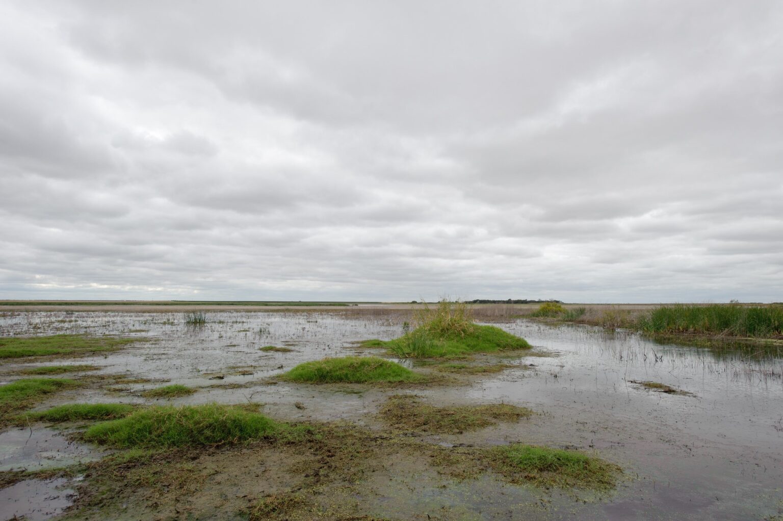

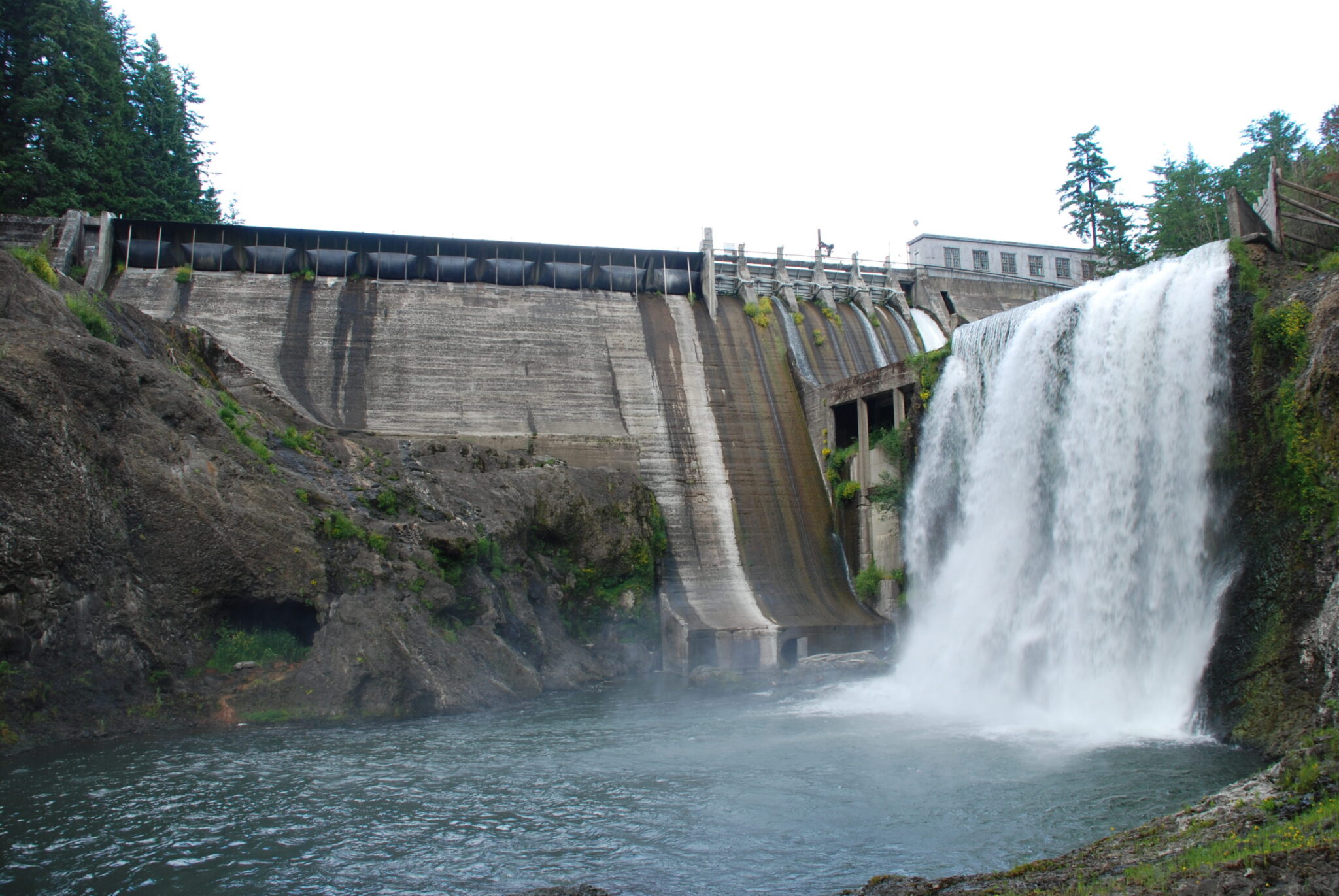
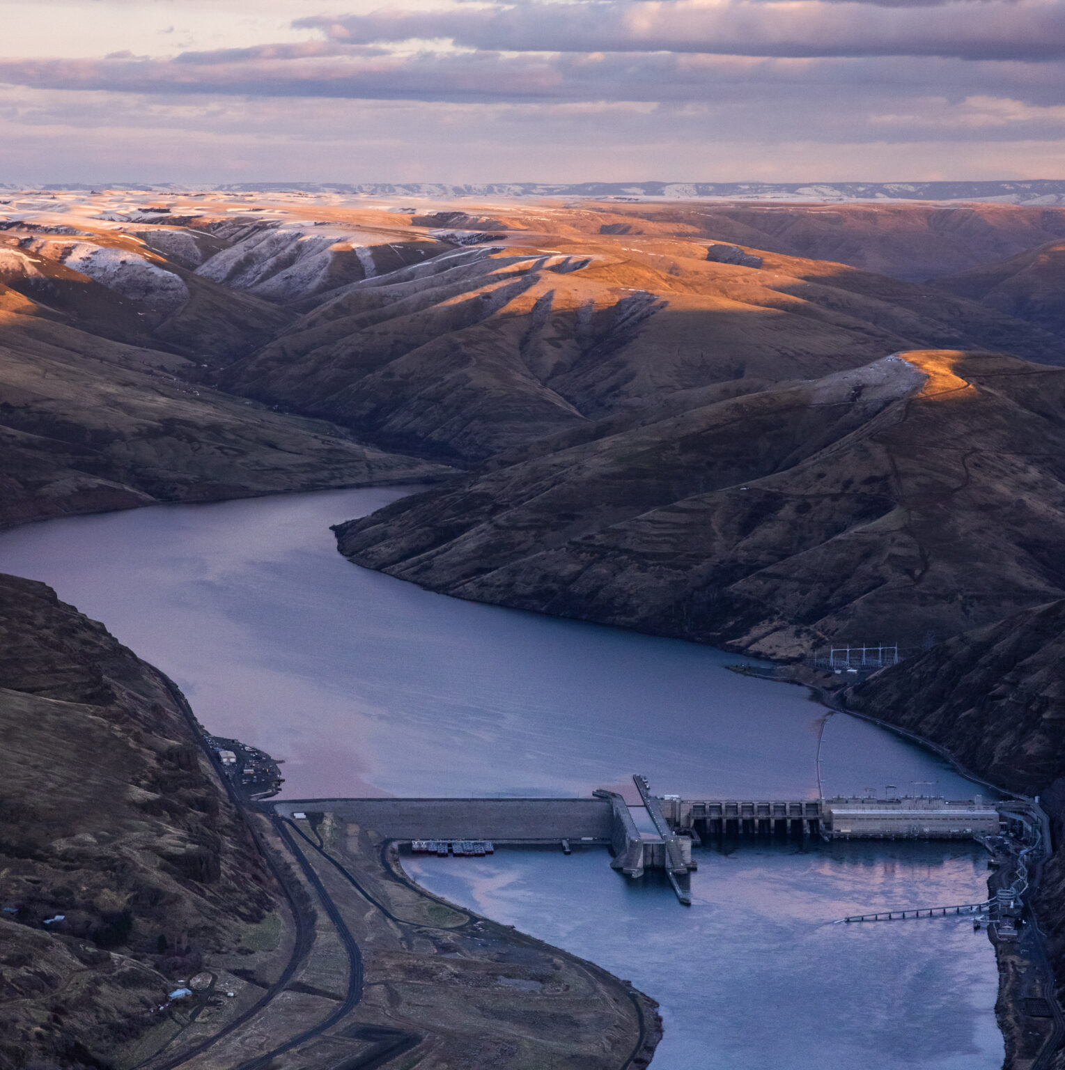
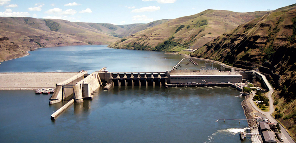
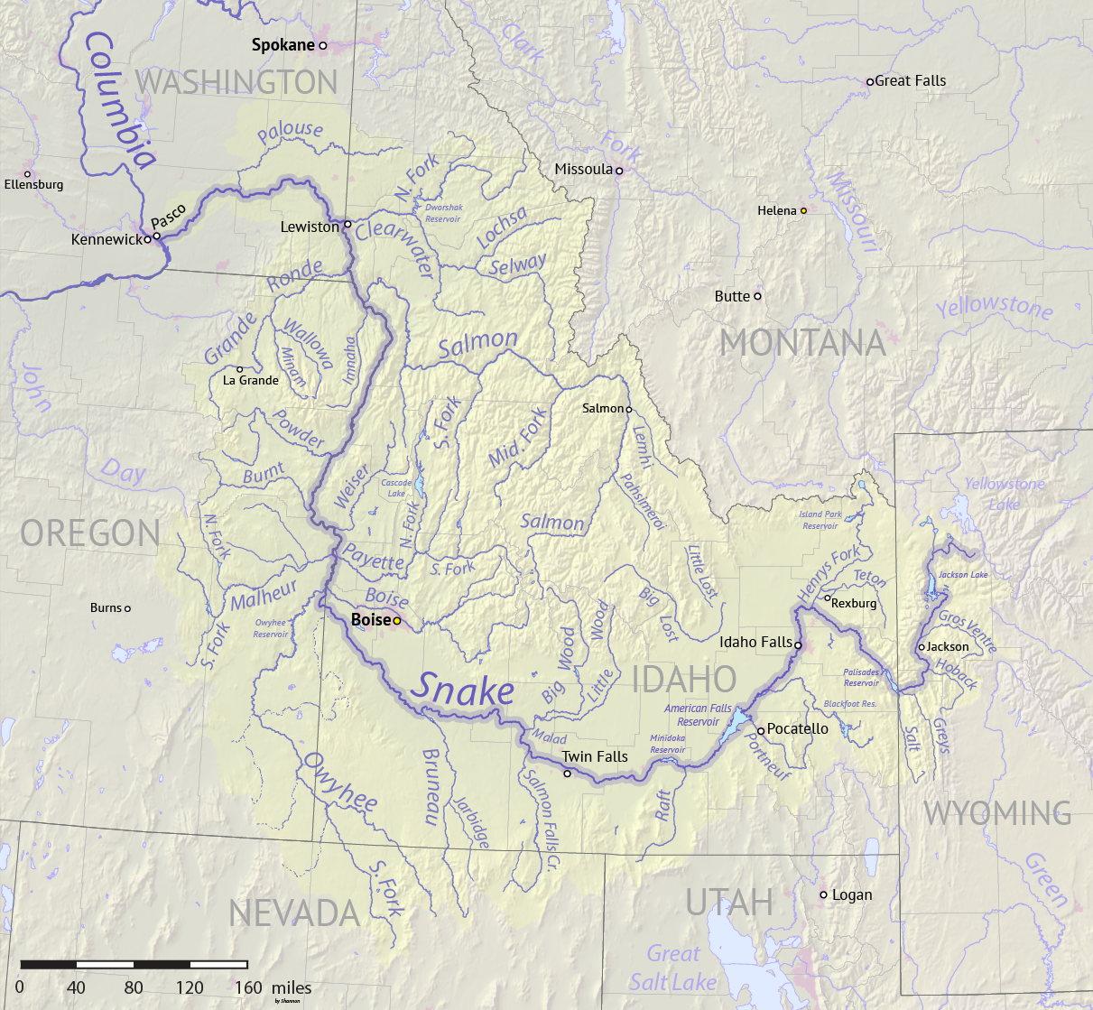
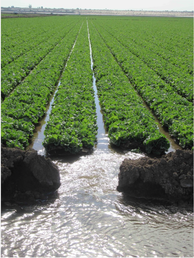


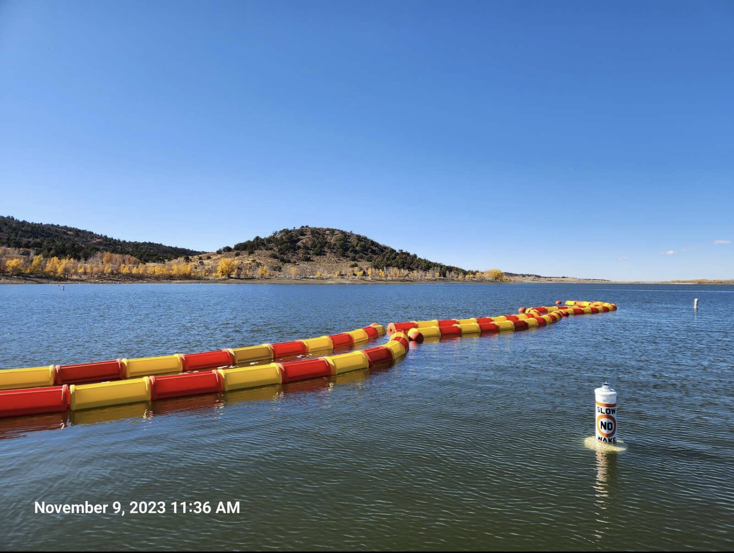

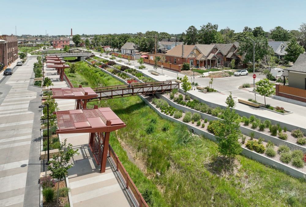


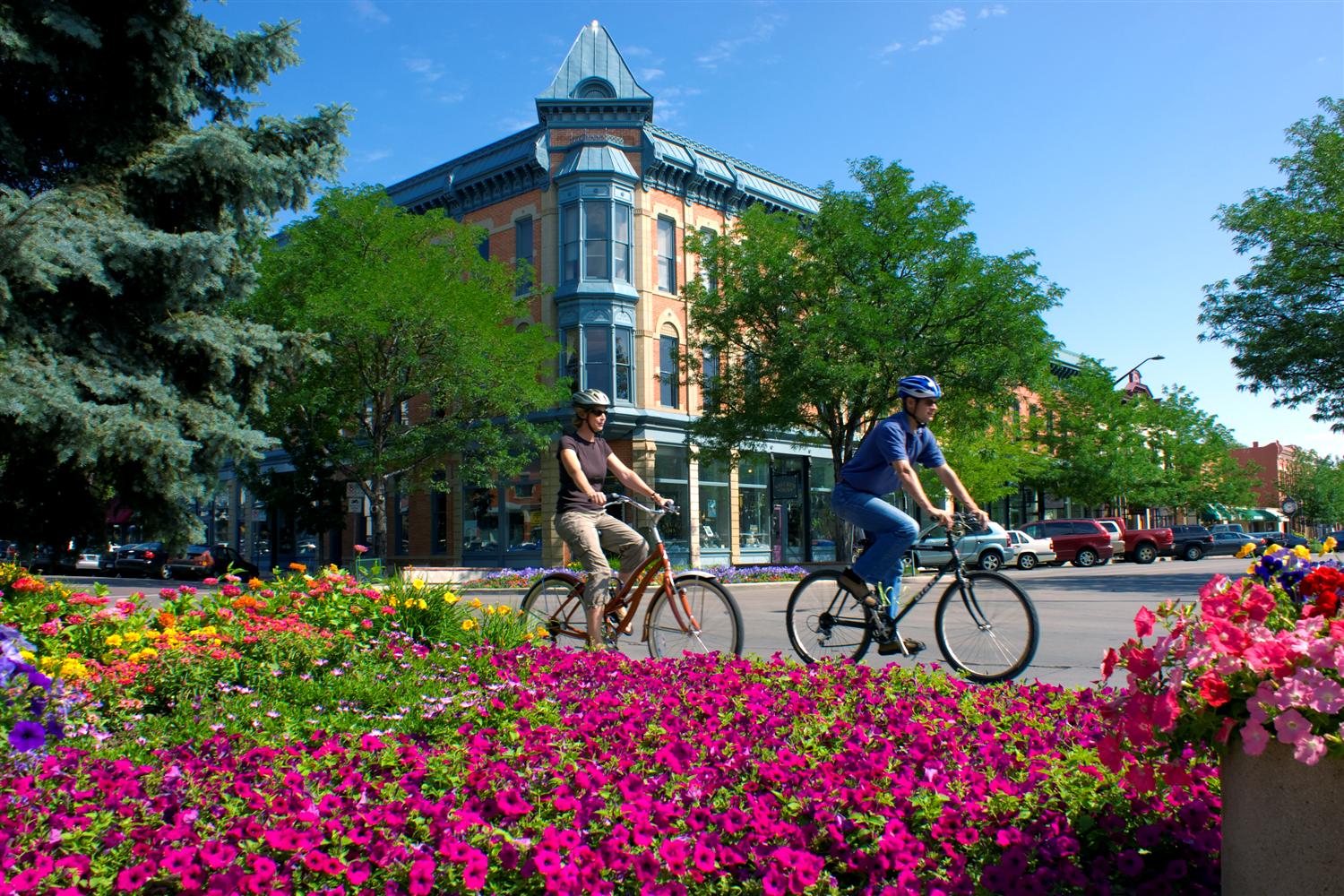


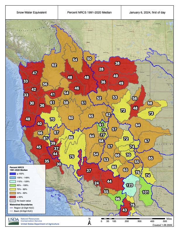
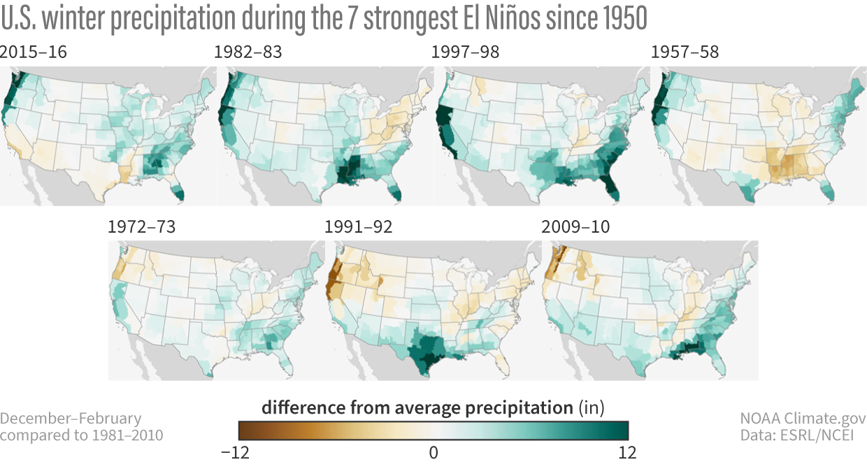
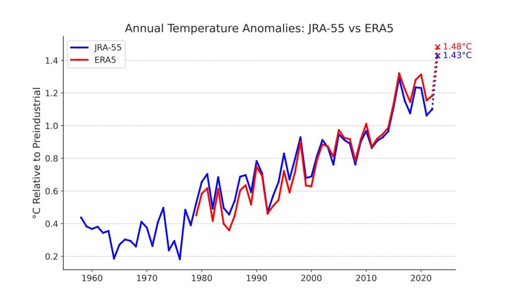

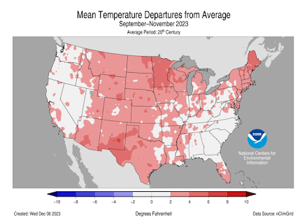
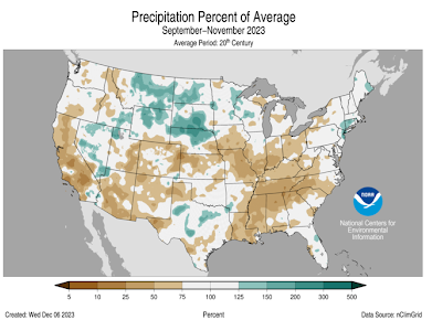


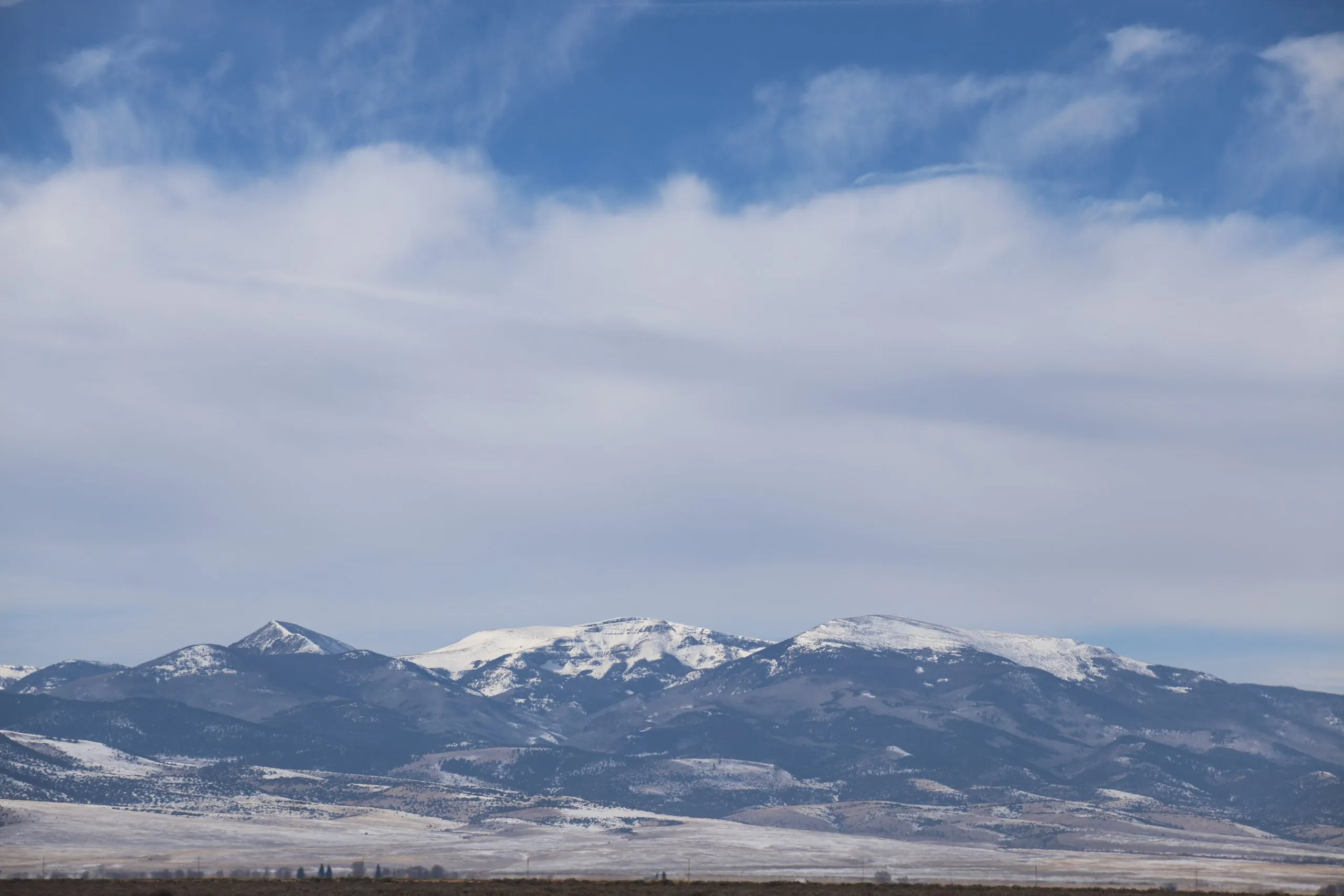
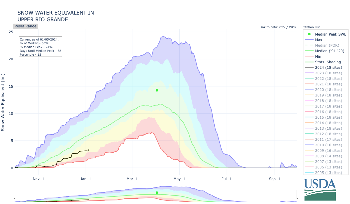
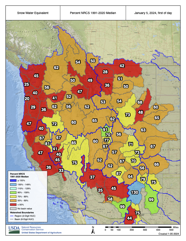


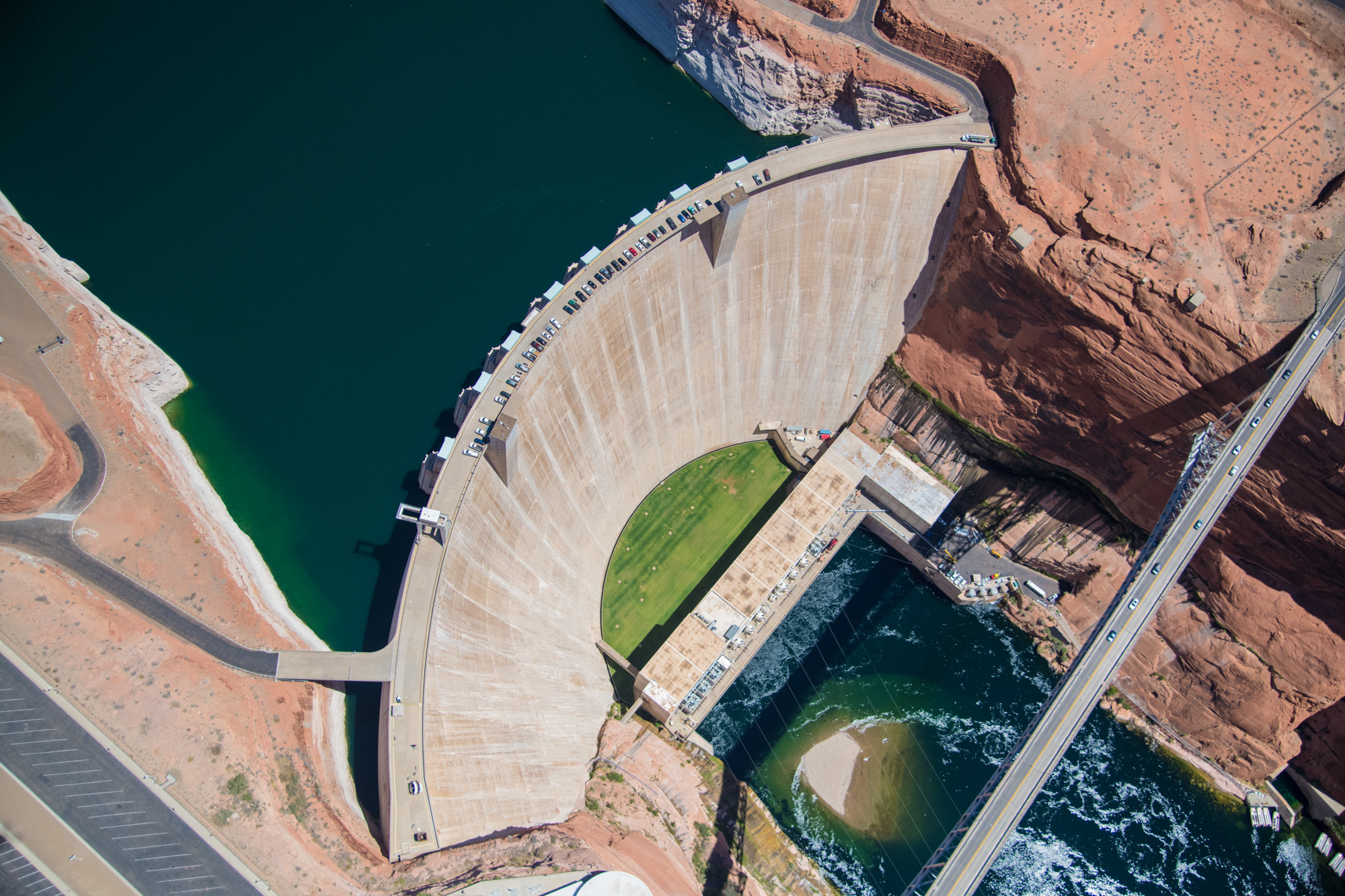
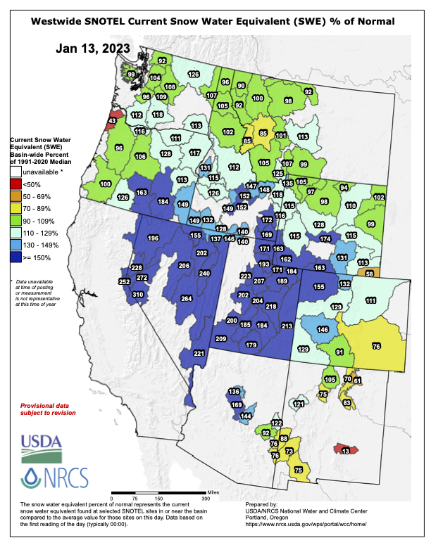


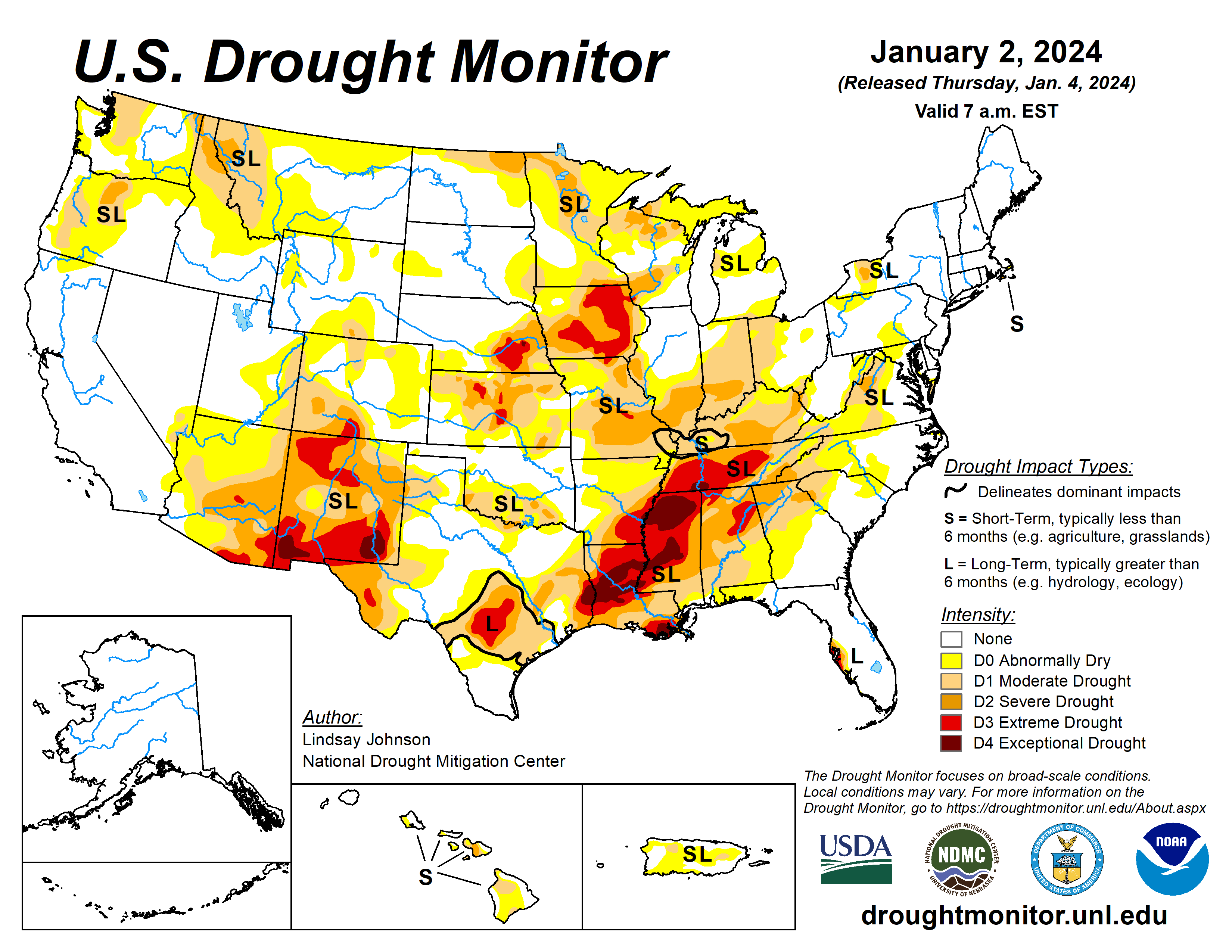
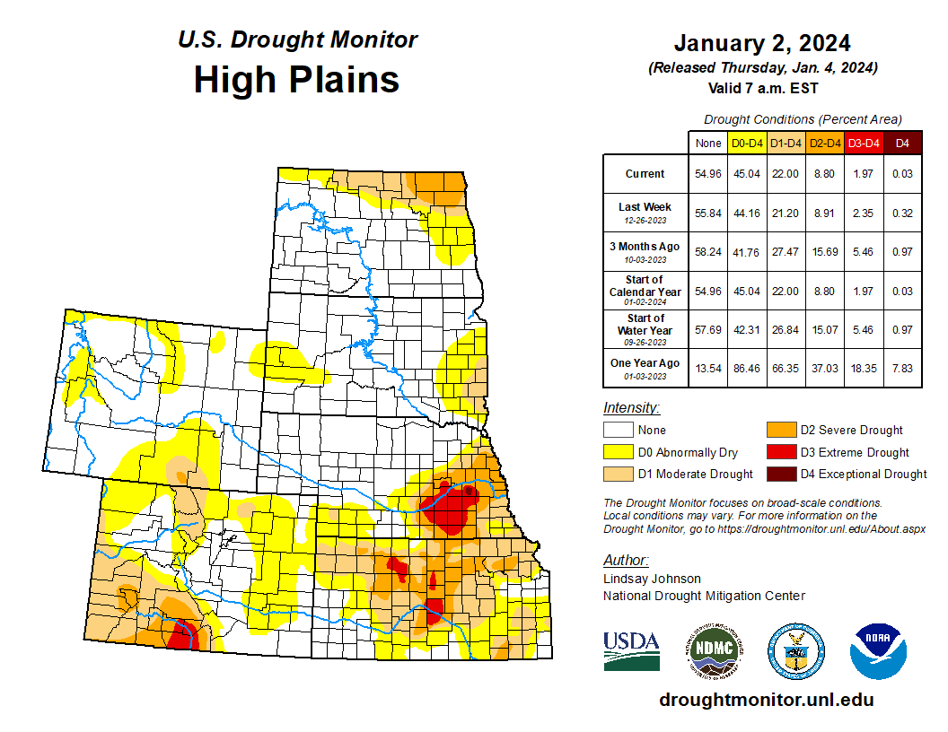

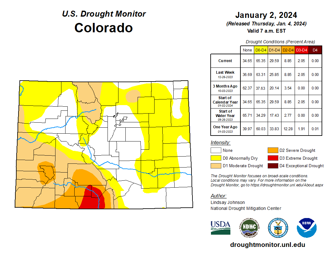
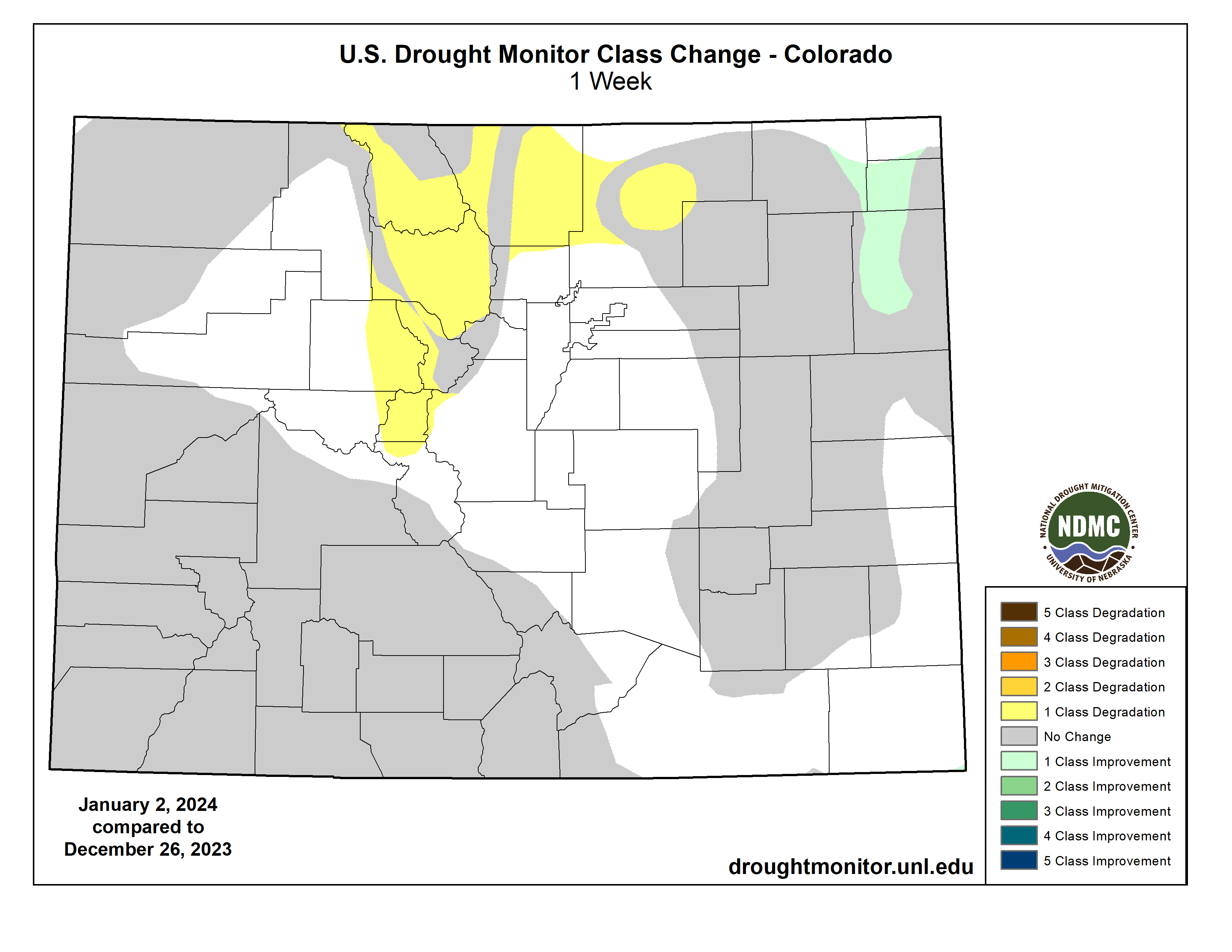
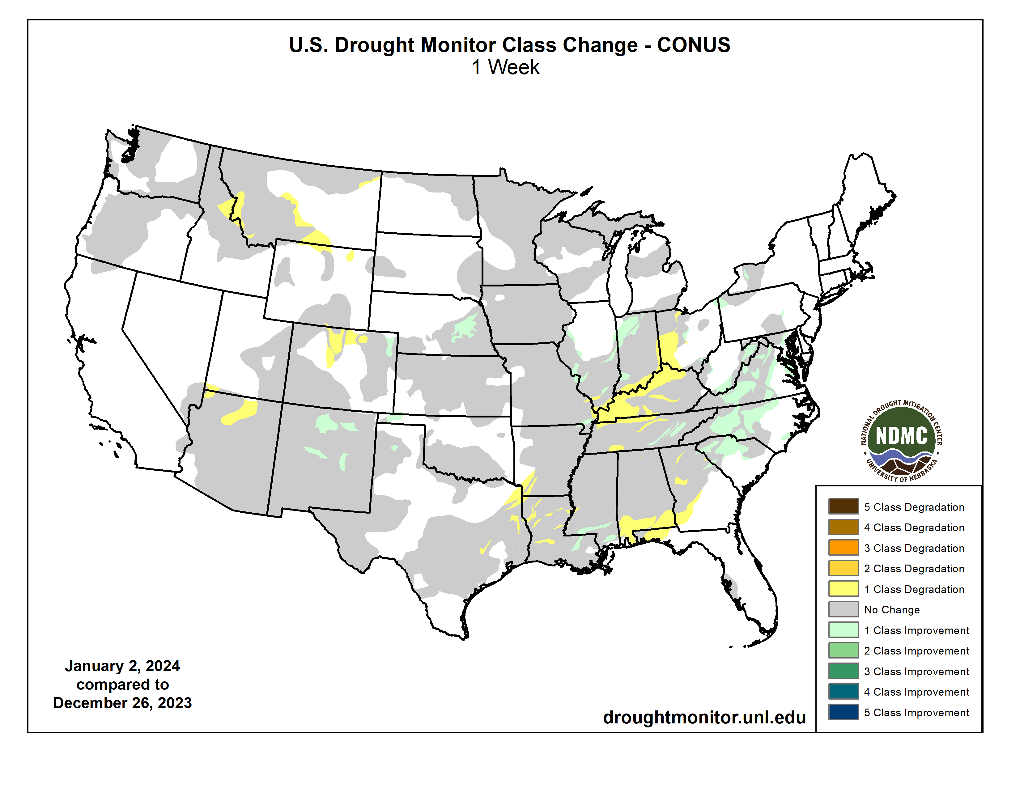

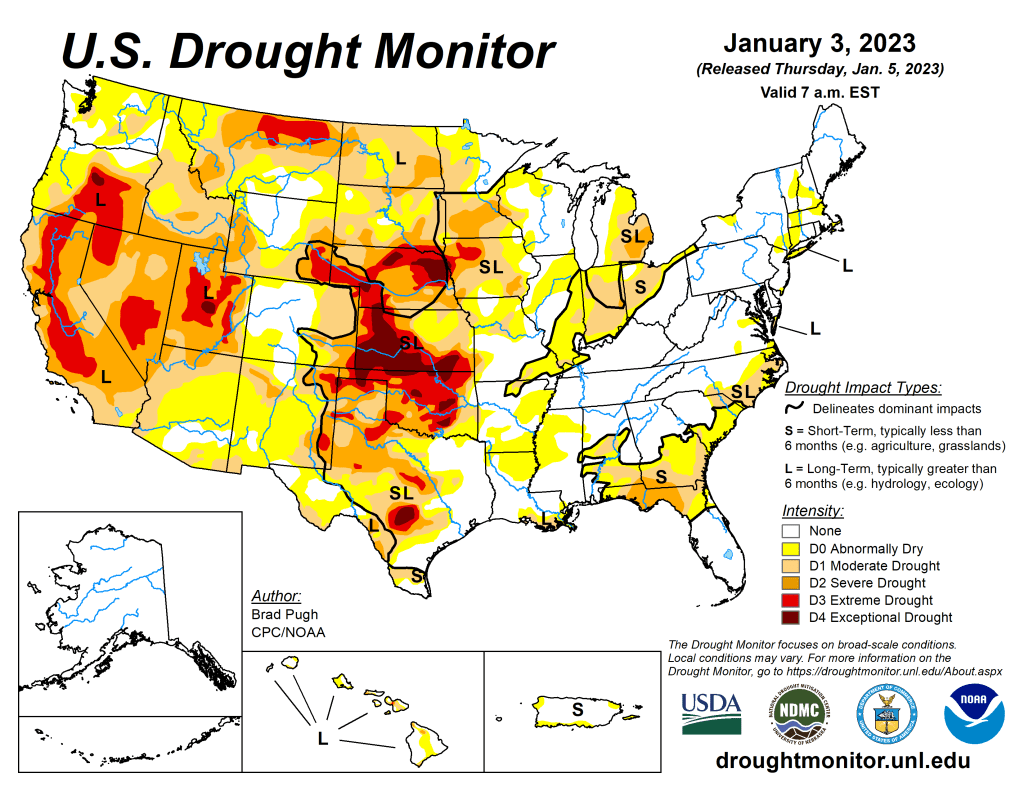


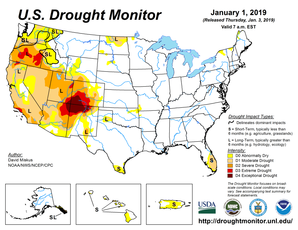
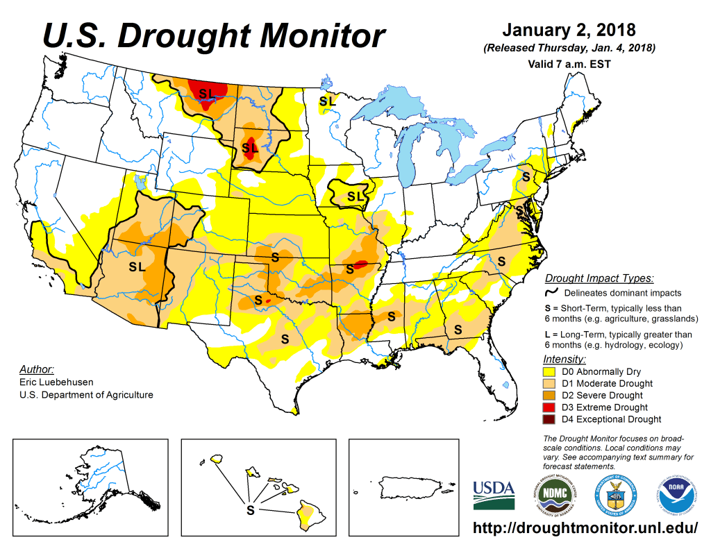
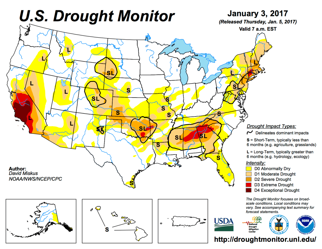

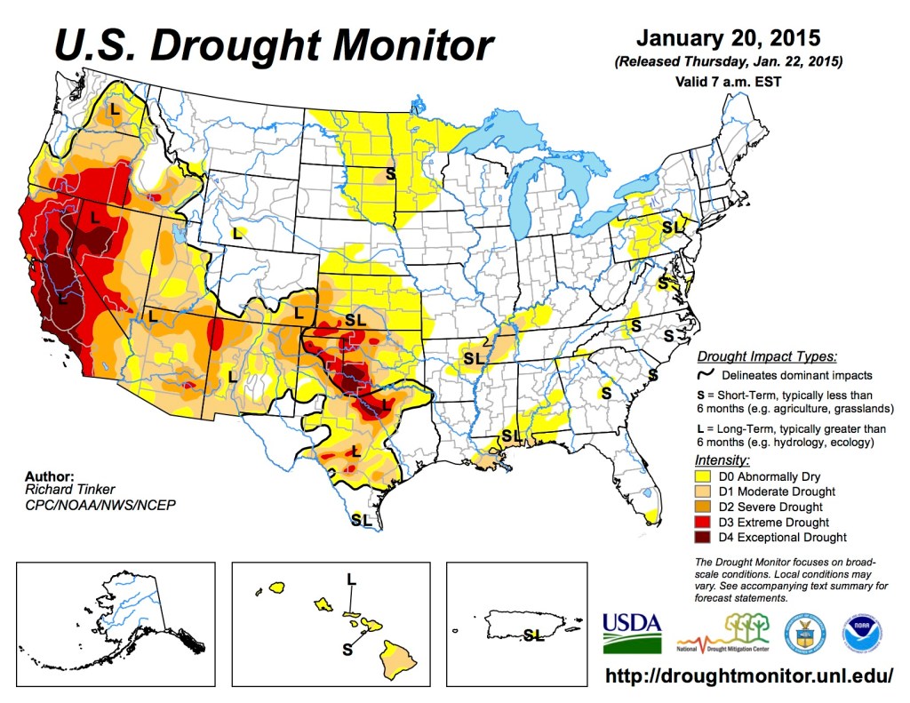

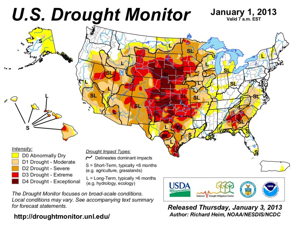
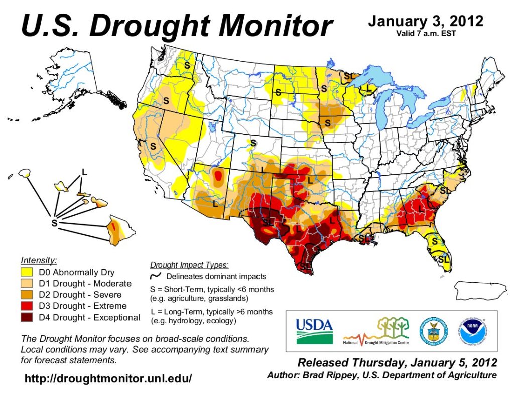
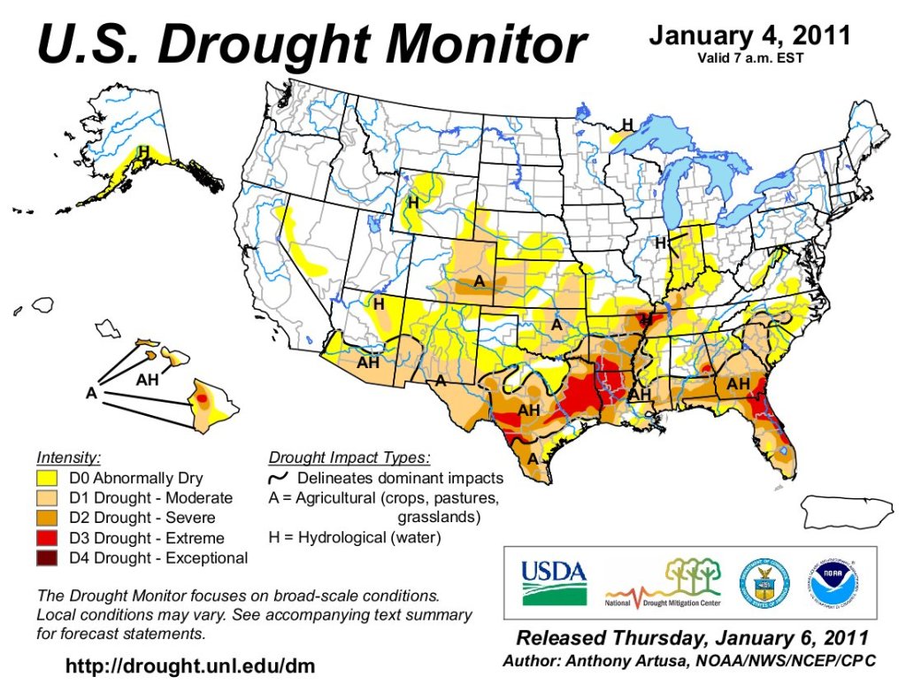


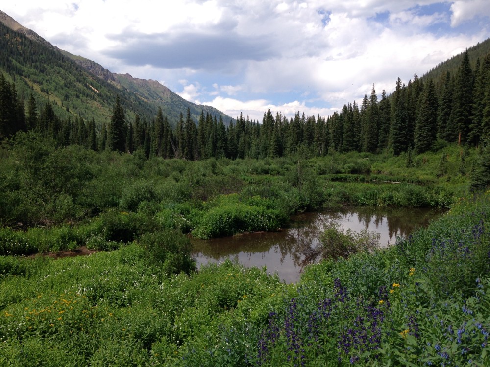
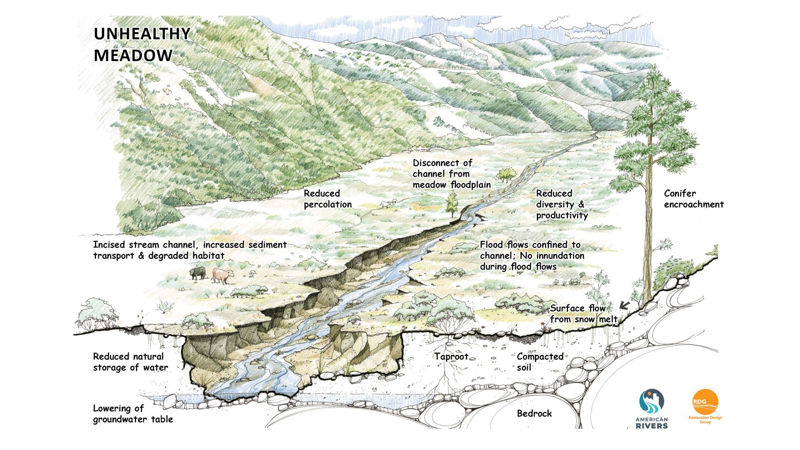


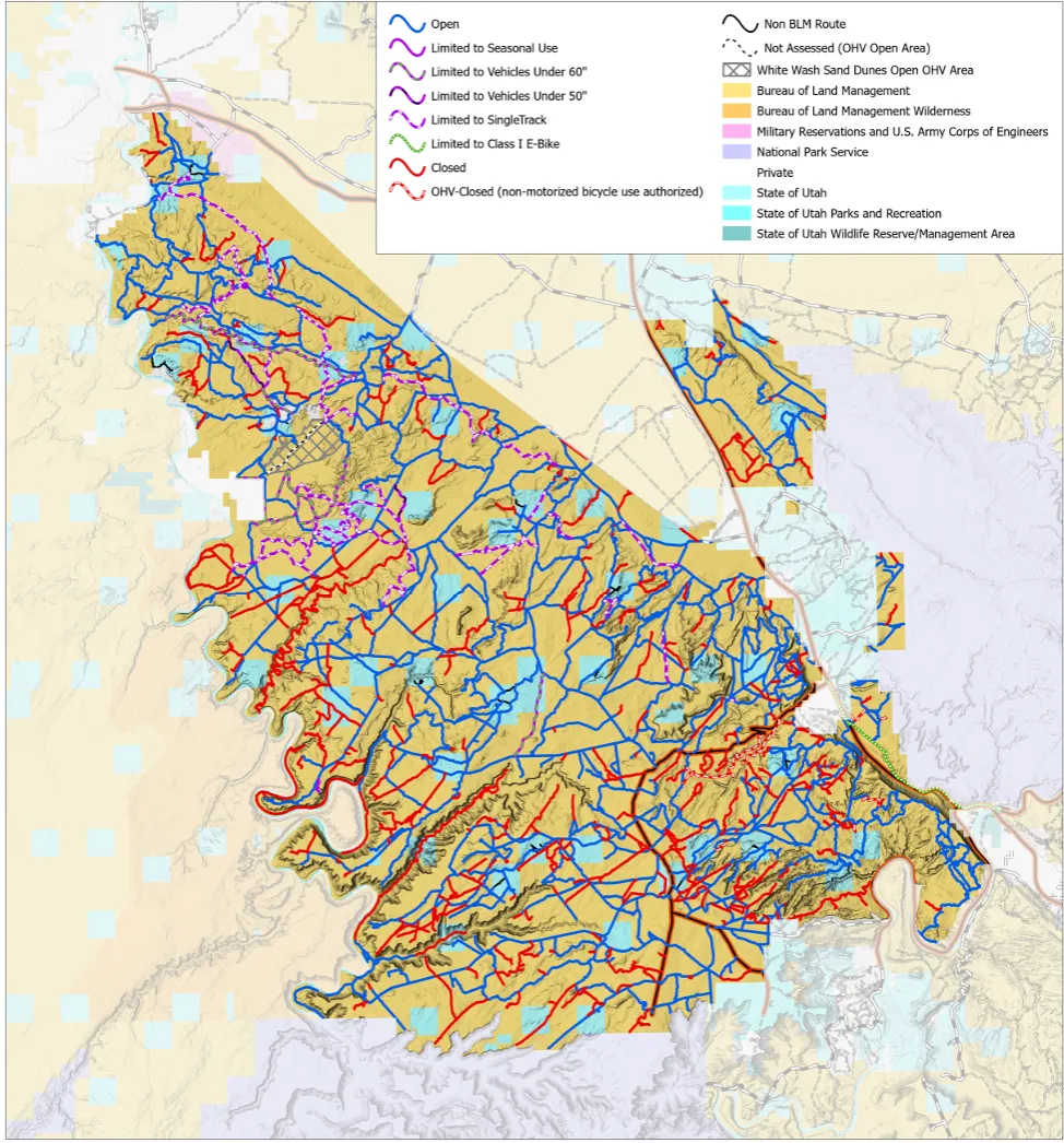
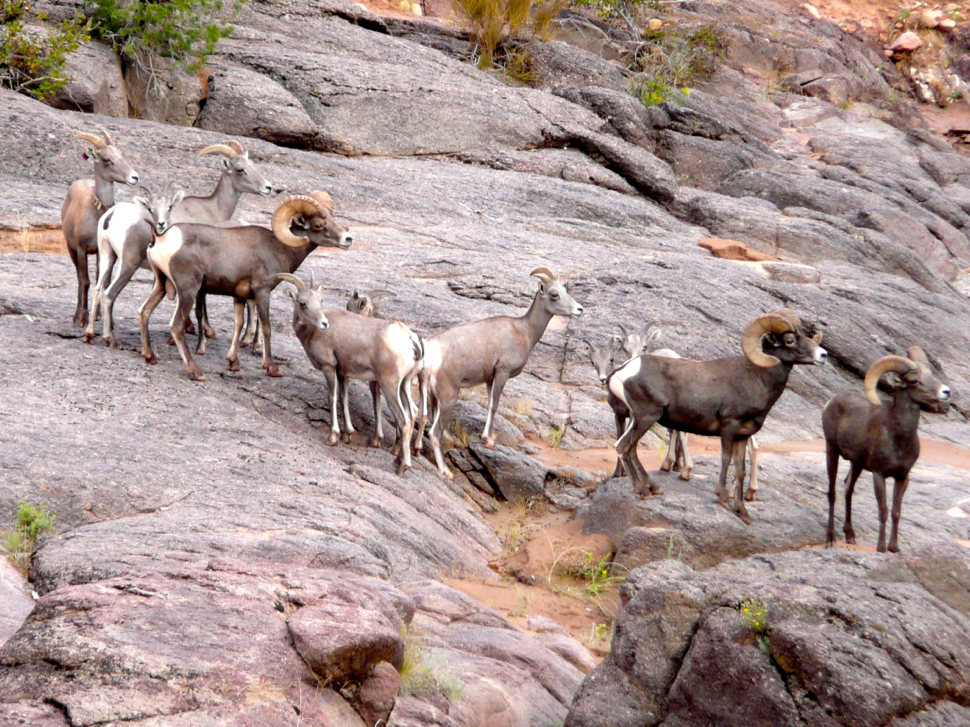
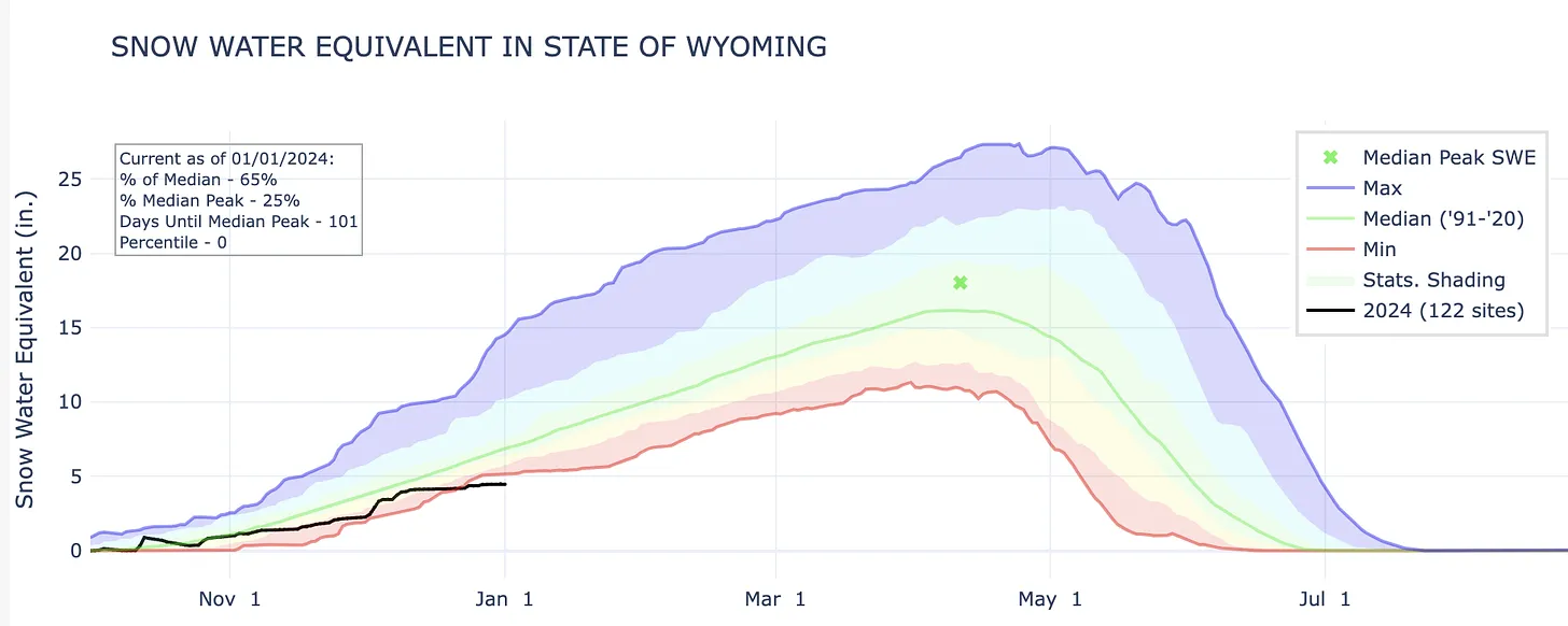
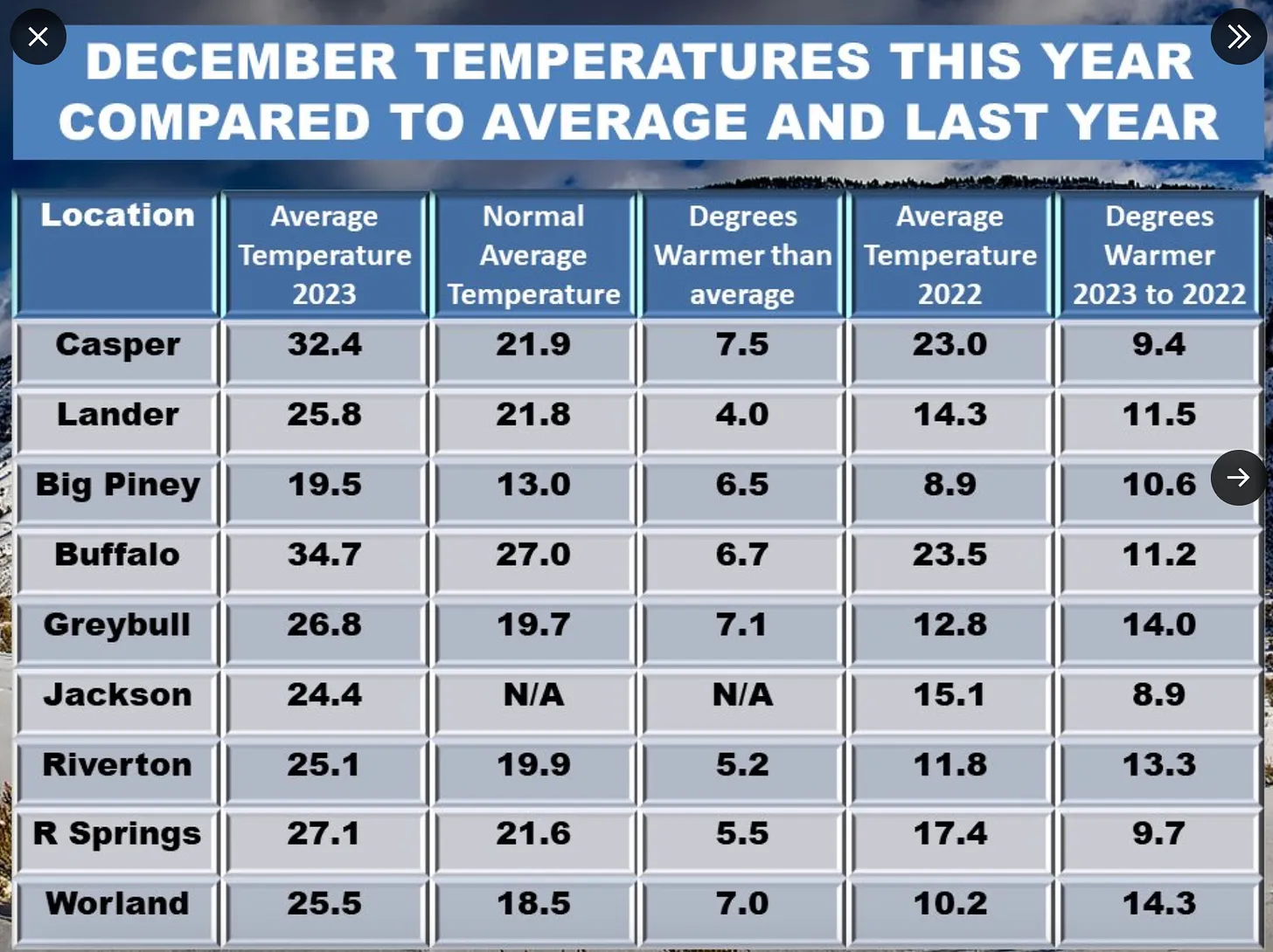

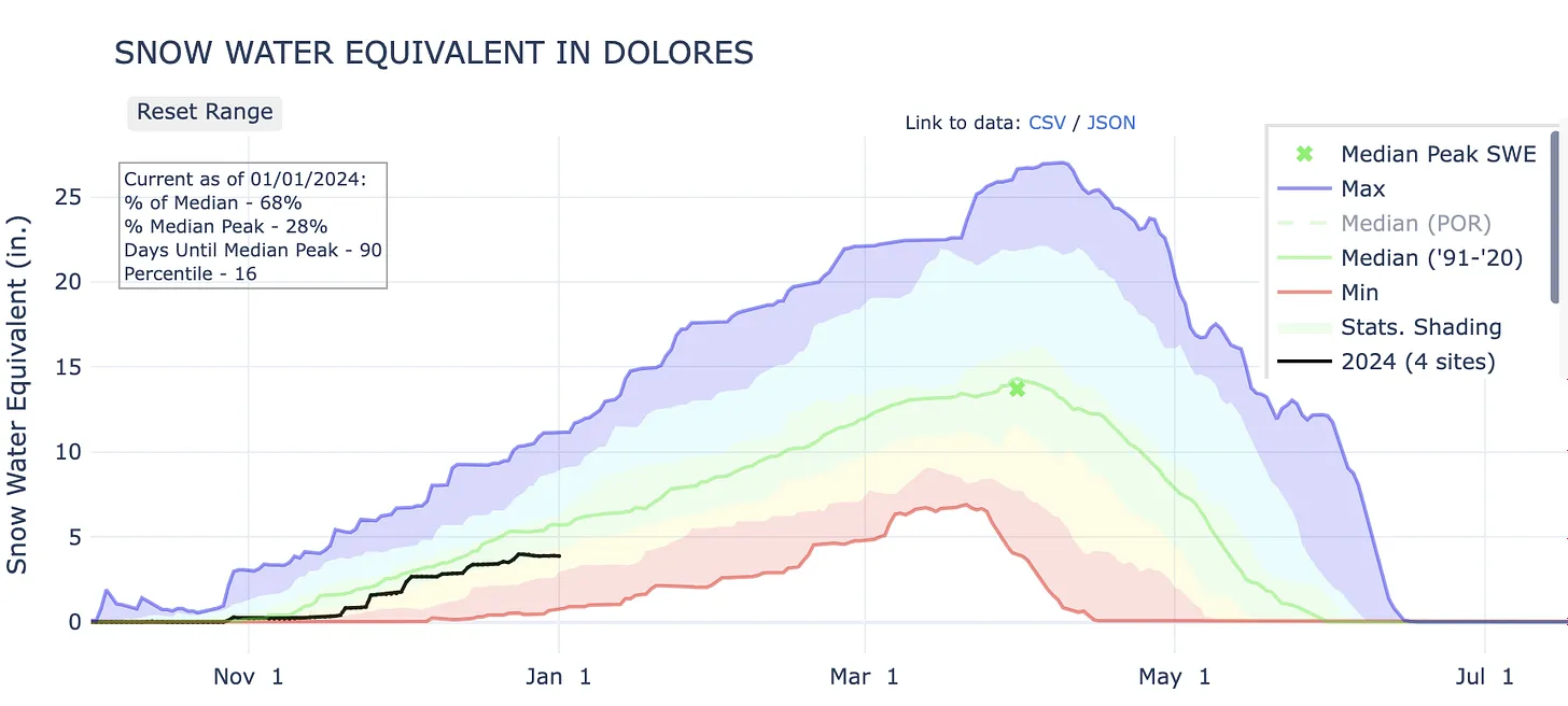


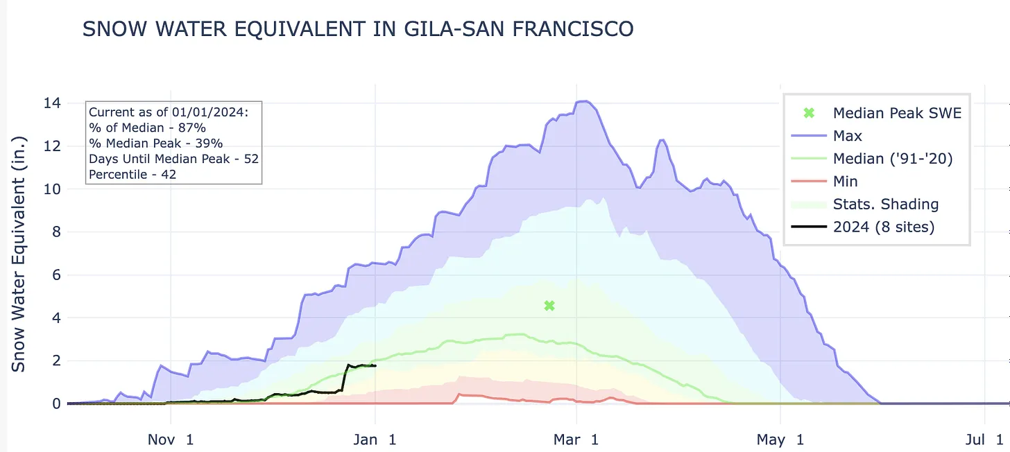

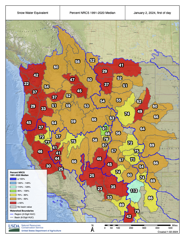
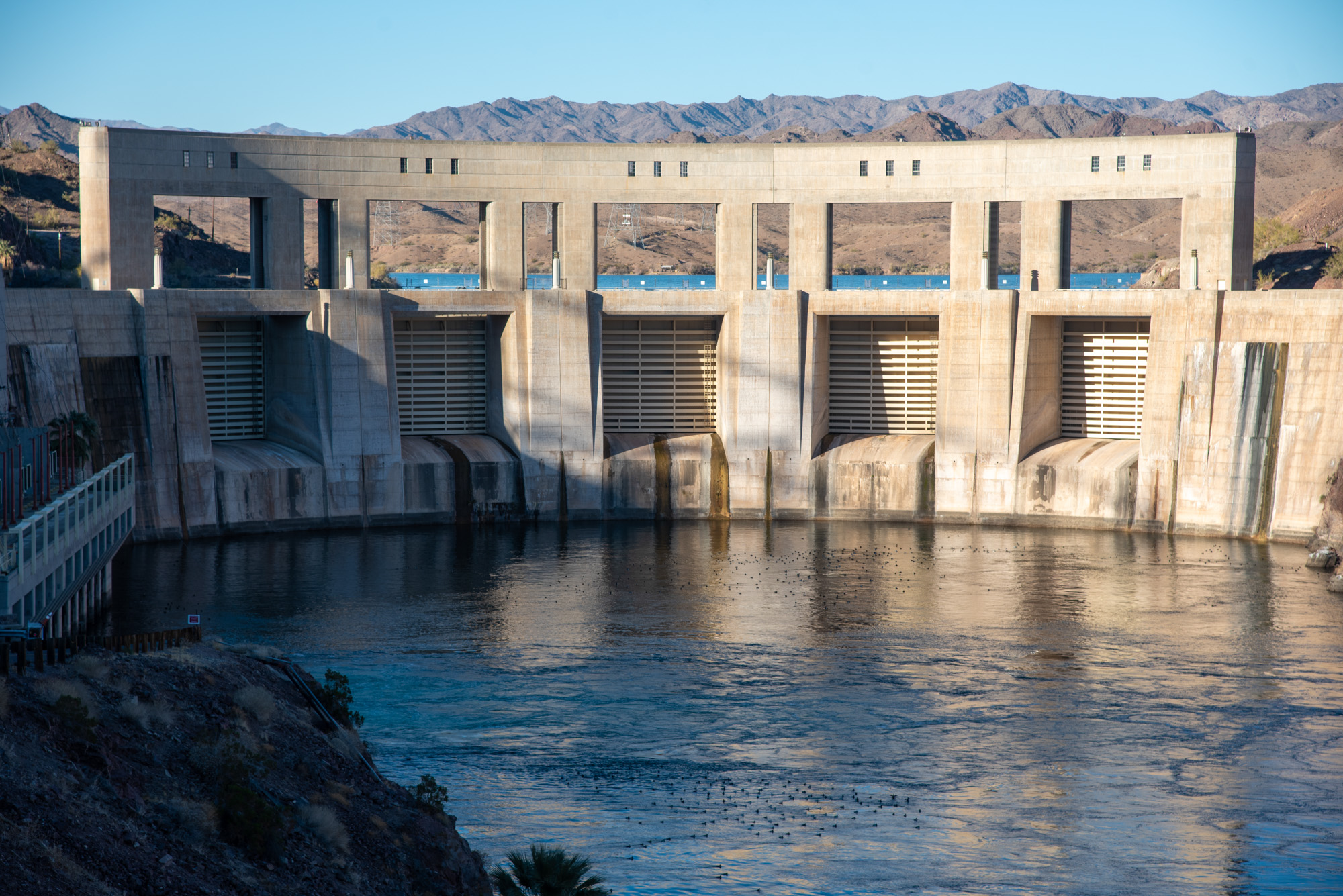
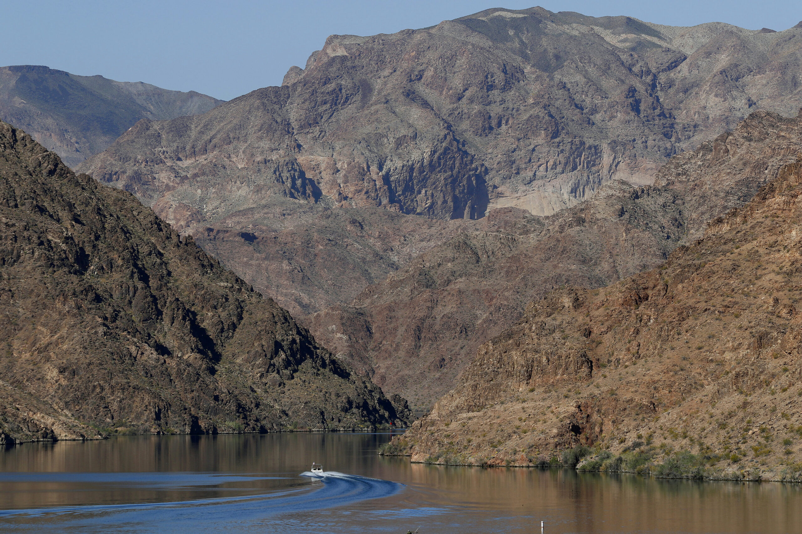
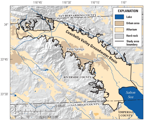
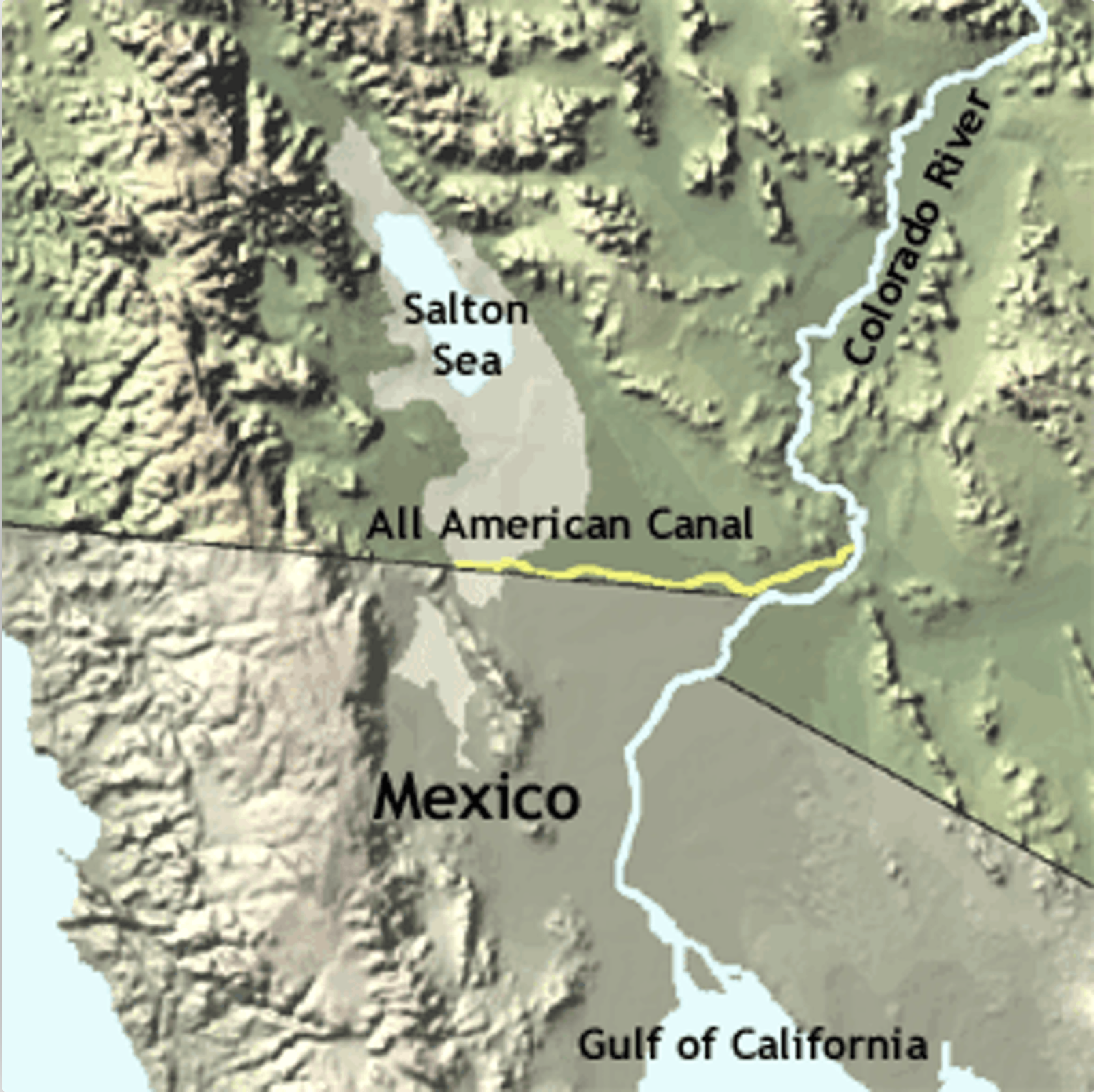
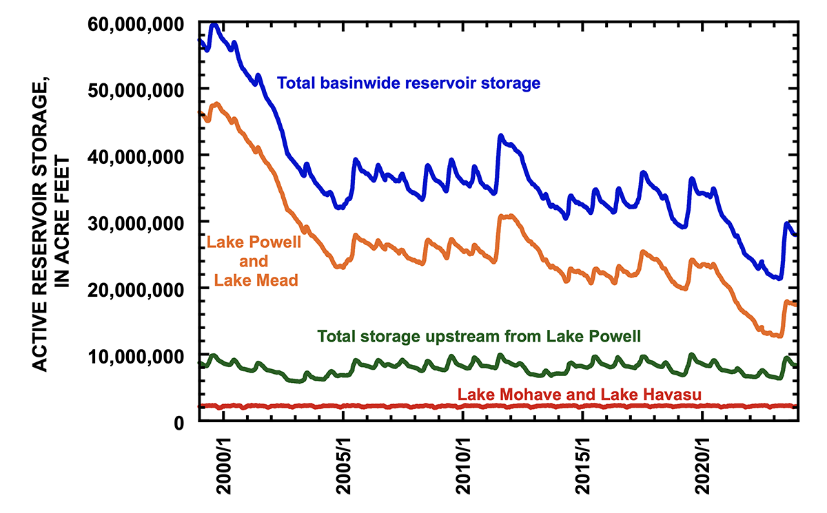
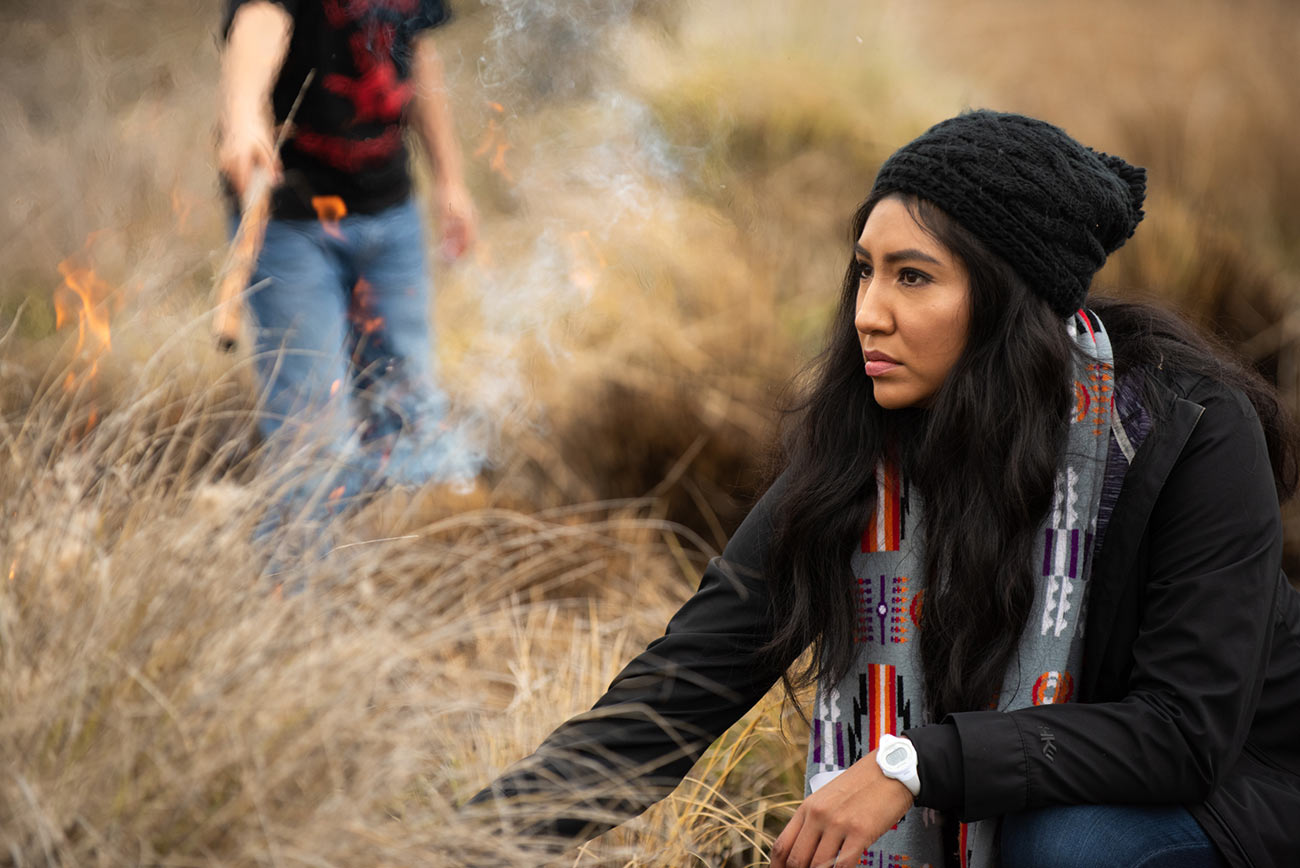
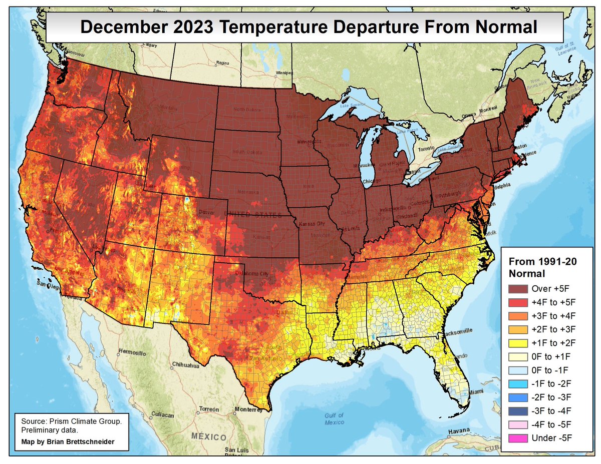
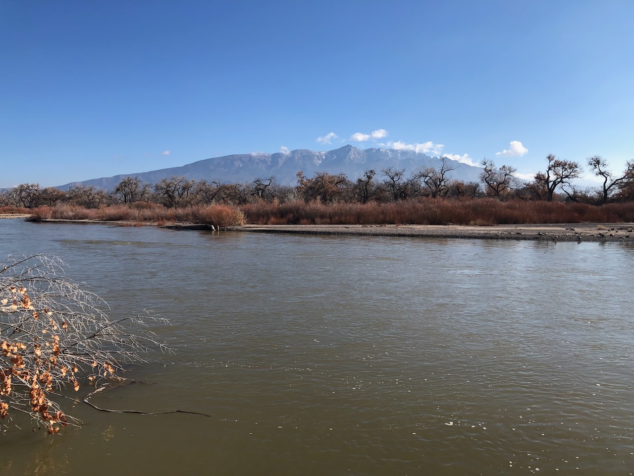
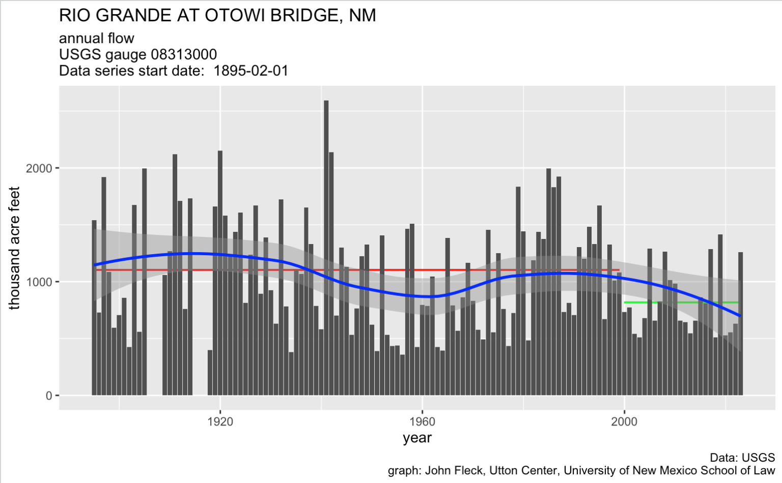
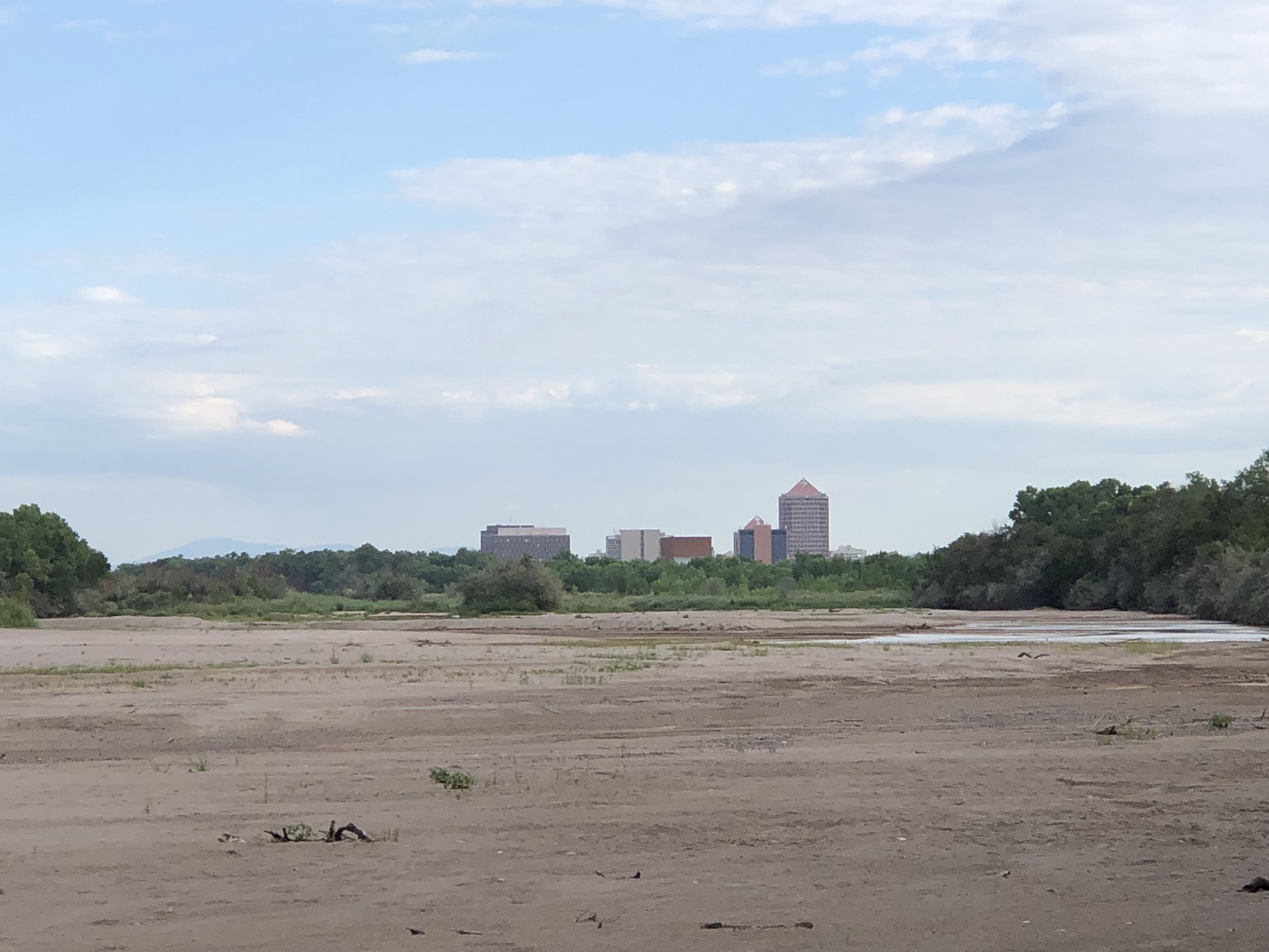
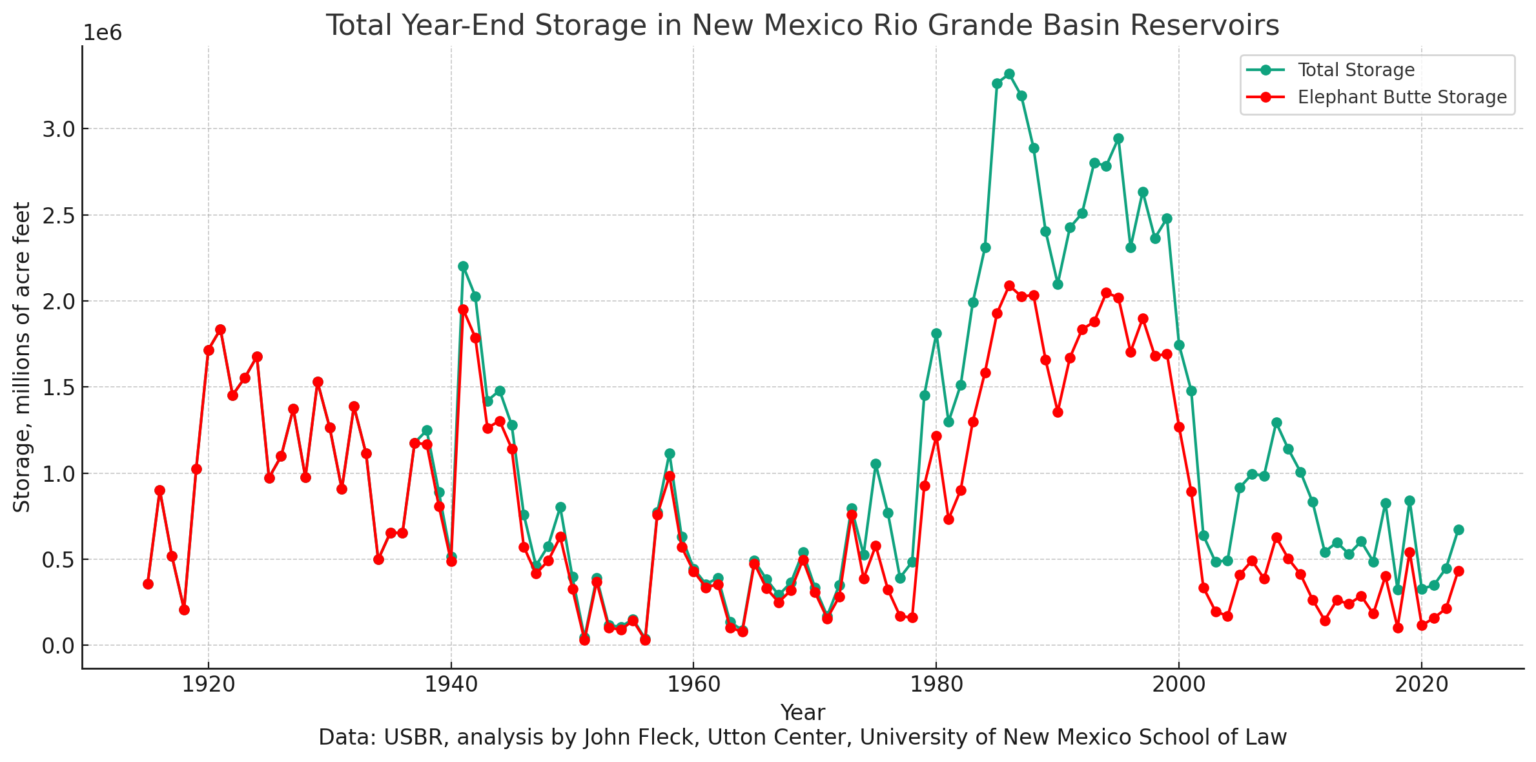


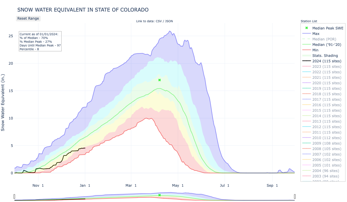
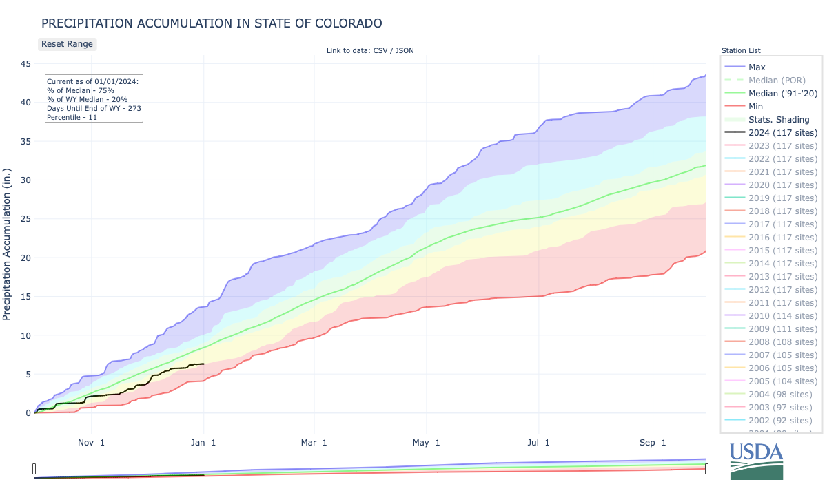

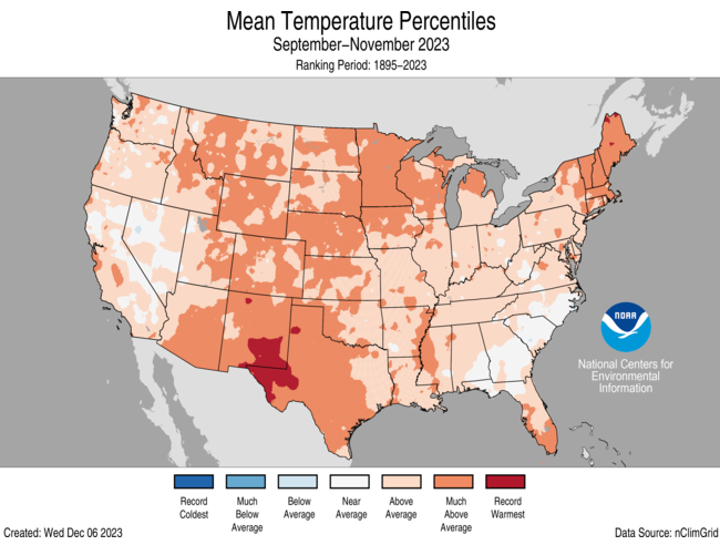
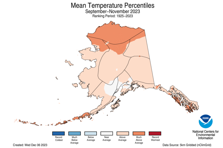
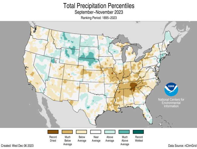