The Colorado General Assembly’s Interim Water Resources and Agriculture Review Committee recommended two bills for consideration next session, which will begin in January 2023, at its third and final meeting on Sept. 22. One would change the committee from an interim to a year-round committee, and the other would create a task force to explore the use of snowmaking by ski areas as an alternative form of water storage.
Joint Water Committee
George Washington addresses the Continental Congress via Son of the South
The committee unanimously recommended a bill that would change its status from an interim committee — limited to meeting after the legislature adjourns each session — to a year-round committee that would meet at least four times each year. Its purposes would remain the same: “contributing to and monitoring the conservation, use, development, and financing of the water resources of Colorado for the general welfare of its inhabitants; identifying, monitoring, and addressing Colorado agriculture issues; and reviewing and proposing water resources and agriculture legislation.” And its make-up would not change: 10 members, with five appointed by the president of the Senate and two by the minority leader; and five appointed by the speaker of the House of Representatives after consultation with the minority leader.
In proposing the bill, Sen. Cleave Simpson, R-Alamosa, said he was responding to a “sense of urgency, and really approaching almost emergency status in the state about water issues.” He pointed to “challenges from Nebraska on the South Platte, [and] declining reservoirs in the Colorado River system” that would benefit from giving the committee “the ability to meet as needed throughout the course of the year.”
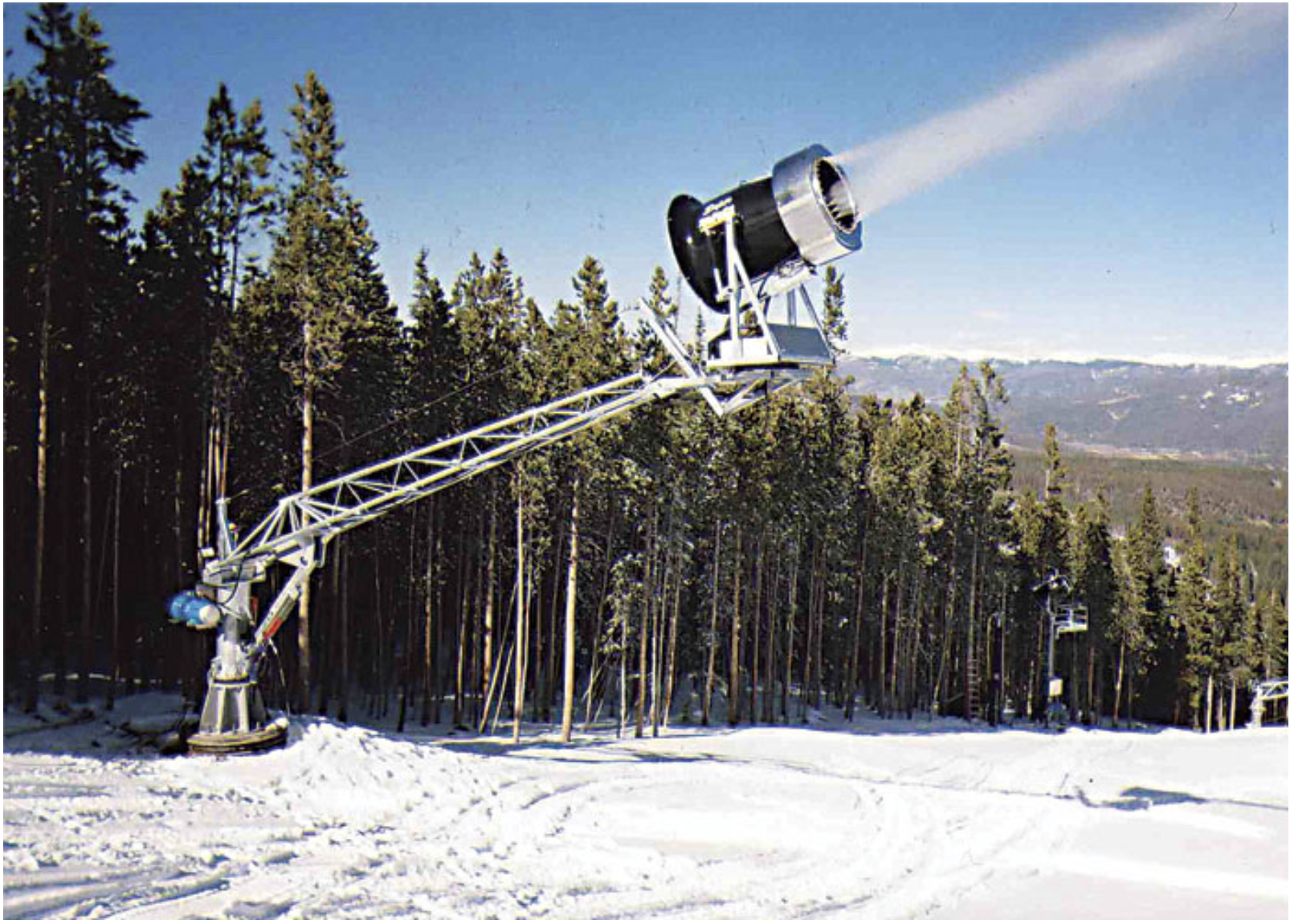
High-Altitude Storage
The committee also unanimously recommended a bill that would create a seven-member task force to study and report back on the feasibility of using high-altitude snowmaking to serve as water storage. Task force members would include the state engineer, two state legislators, a representative of the ski industry and one from the whitewater rafting industry, an engineer with experience in high-altitude hydrology, and staff from the U.S. Forest Service. If the bill passes, the task force would meet no later than Nov. 1, 2023, and report its findings and any recommendations to the committee by June 1, 2024.
Snowmaking. Photo credit: Allen Best
At an earlier committee meeting in August, Rep. Hugh McKean, R-Loveland, said he had been mulling the concept of an alternative water storage system and this approach “would allow ski resorts to blow other people’s water as snow up into the high woods to extend the snowmelt by 30-45 days and literally allow them to create storage up high as snow.” He thought this could be a “transformative way of storing water in the state of Colorado that does some things for an industry we depend on, and does some things to delay water coming down, in some cases, until we really need it.”
In introducing the bill, Rep. McKean acknowledged that “this is intended to be a conversation” to explore whether the idea makes sense. He was looking for the task force to help determine if “there is a financial and logistical way of increasing storage at high altitude.”
Other Issues
The committee had seven other bills before it but all were withdrawn by their sponsors, citing the need for additional work. Among those receiving testimony was a bill that would restrict a homeowners association from unreasonably requiring the use of either rock or turf grass on more than a certain percentage of a homeowner’s landscape and providing an option for drought-tolerant plantings on the rest of the property. Another bill would provide legal protections and financial incentives to treat nontributary water that is “developed,” or brought to the surface, as a byproduct of oil and gas operations for other beneficial uses.
Larry Morandi was formerly director of State Policy Research with the National Conference of State Legislatures in Denver, and is a frequent contributor to Fresh Water News. He can be reached at larrymorandi@comcast.net.
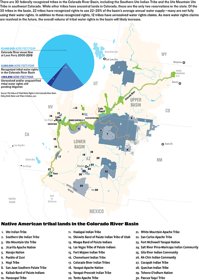
Colorado and three other Upper Colorado River Basin states have, for the first time in history, embarked on a series of formal meetings to find a way to negotiate jointly with some of the largest owners of Colorado River water rights: tribal communities.
The states, which include New Mexico, Utah, Wyoming and Colorado, began meeting with six tribes several weeks ago, according to Rebecca Mitchell, director of the Colorado Water Conservation Board who also represents Colorado on the Upper Colorado River Basin Commission.
The tribes are the Jicarilla Apache Nation in New Mexico, the Navajo Nation in New Mexico and Utah, the Ute Indian Tribe of the Uintah and Ouray Reservation, and the Paiute Tribe in Utah, as well as Colorado’s Ute Mountain Ute Tribe, based in Towaoc, and Southern Ute Indian Tribe, whose lands lie in and around Ignacio.
“We have four Upper Basin states and the six Upper Basin tribes, 10 sovereigns, in the room together saying that the table that is set is not the table that works for all, and we are going to create our own table. They are really focused on solutions and being part of the burden and part of the success,” Mitchell said.
The six tribes are among 30 tribal communities in the seven-state Colorado River Basin, which, combined, have paper water rights to roughly 25% to 30% of the river’s flows, more than 3.2 million acre-feet of water.
The news came Sept. 16 at the Colorado River District’s Annual Seminar in Grand Junction. The river district represents 15 counties on Colorado’s West Slope and is responsible for policy and managing the river within those boundaries.
For more than 100 years, modern water management in the American West has been conducted by the federal and state governments, without formal tribal leaders.
Under Western water law, water has to be measured, its historical use rates certified, and it has to be diverted so that it can be put to beneficial use. Tribal water rights are treated differently. Tribes’ water rights date back to the time when the reservations were created, based on a law that was applied retroactively – many reservations were established before the law existed and so the amount of water they received was never quantified or adjudicated. For this reason, many tribes have had to settle their water rights within the state or states where their reservation lies— some of those negotiations remain unsettled. Many tribes have never measured their water use and, even among those tribes with quantified water rights, many have never had the money to build the dams, pipelines and reservoirs that allow them to put the resource to use.
Roughly 60% of the water the tribes legally possess has never been developed or integrated into the region’s hierarchy of water rights, though they are often some of the oldest, according to tribal estimates.
Daryl Vigil, Jicarilla Apache Nation Water Administrator, said tribal leaders want the federal government to create a new framework to right past wrongs and establish a process for tribes to participate in critical river negotiations.
For too long, he said, “The policy-making process has been left up to the seven basin states and the federal government. We want to speak on behalf of our own water. We’ve heard a whole lot about scarcity and pain,” he told the Grand Junction audience of roughly 400 people. “And we know a whole lot about that. We’re asking, we’re demanding participation because it is a basic human right.”
During the past five years, as the Colorado River has sunk deeper into crisis, the tribes have begun working together and asserting their right to negotiate with federal, state and local water agencies to determine how their water will be used, how badly needed tribal water systems can be built, and how tribes can be fairly compensated for the water that has long been used by others.
Despite increased public pressure to recognize the tribes’ water rights and to include them in critical negotiations and decision-making processes, they continue to be shut out, including in the most recent talks over how to achieve the 2 million to 4 million acre-feet of cuts that U.S. Bureau of Reclamation Commissioner Camille Touton ordered back in June in order to keep lakes Mead and Powell operating.
Another set of critical talks set to begin in the near future still has no mechanism for including the tribes. These are talks that will determine how to operate the river well into the future, after the current framework for river operations, known as the 2007 Interim Guidelines, expires at the end of 2026. Tribes were not included in the talks leading up to the 2007 agreement either.
Lorelei Cloud, a member of the Southern Ute Tribal Council, said traditional water users in the Colorado River Basin won’t survive unless tribal waters are legally recognized, developed and put to use by tribes and other users in the basin.
“We are a sovereign government. We should be considered just as a state would be. If you think that we shouldn’t be involved, then don’t include our 30% allocation for anyone else’s use … We need to be included in every one of these conversations. My reservation was established in 1868. We are first in time first in line. You cannot discount us,” she said.
Jerd Smith is editor of Fresh Water News. She can be reached at 720-398-6474, via email at jerd@wateredco.org or @jerd_smith.
Native land loss 1776 to 1930. Credit: Alvin Chang/Ranjani Chakraborty
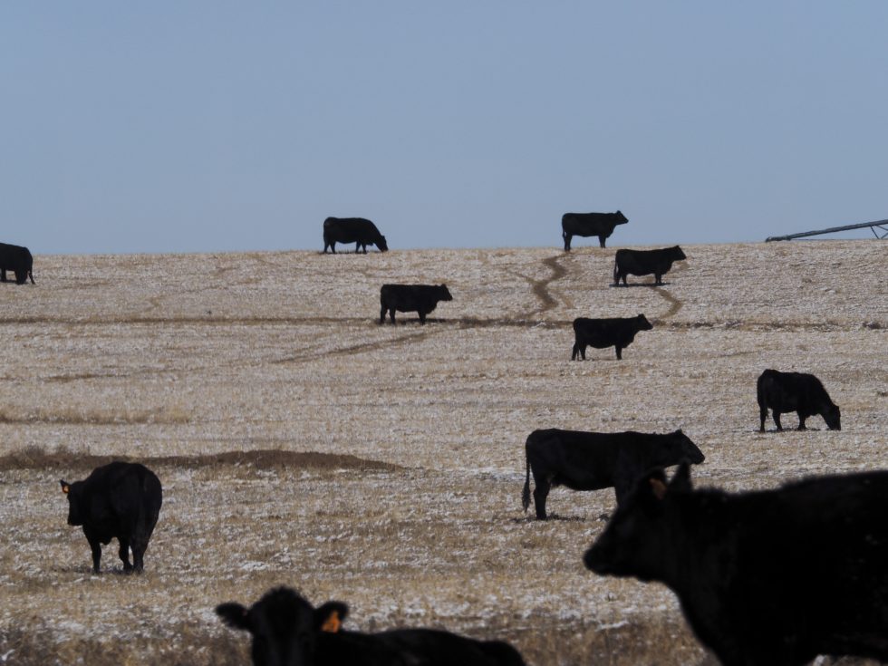
Cattle of the Bow & Arrow herd, graze in a frosted corn field on the 7,770 acre Ute Mountain Ute Farm & Ranch Enterprise near Towoac, Colorado. About 700 head of cattle, graze on the farm and ranch lands during the winter. During the summer the herd is moved to mountain pastures. (Dean Krakel photo, special to EWC)
At Spring Born, a greenhouse in western Colorado near Silt, you see few, if any, dirty fingernails. Why would you? Hands never touch soil in this 113,400-square-foot greenhouse.
You do see automation, long trays filled with peat sliding on conveyors under computer-programmed seeding devices. Once impregnated, the trays roll into the greenhouse.
Thirty days after sprouting, trays of green and red lettuce, kale, arugula, and mustard greens slide from the greenhouse to be shorn, weighed and sealed in plastic clamshell packages. Hands never touch the produce.
Spring Born says it needs 95% less water compared to leafy greens grown using Colorado River water a thousand miles downstream in Arizona and California. That region supplies more than 90% of the nation’s lettuce. At Silt, the water comes from two shallow wells that plumb the riverine aquifer of the Colorado River, delivering about 20 gallons per minute. The water is then treated before it is piped into the greenhouse. This is agriculture like nowhere else.
he all-mechanized operations at Spring Born’s large greenhouse near Silt, Colo., produce leafy greens by maximizing the use of water. Spring Born says it needs 95% less water compared to greens grown using Colorado River water 1,000 miles downstream in Arizona and California. From the Hip Photo courtesy of Spring Born
Great precautions are taken to avoid contamination and prevent the spread of pathogens. Those entering the greenhouse must don protective equipment.
There’s no opportunity for passing birds or critters to leave droppings. As such, there is no need for chlorine washes, which most operations use to disinfect. Those washes also dry out the greenery, shortening the shelf life and making it less tasty. The Spring Born packages have an advertised shelf life of 23 days.
Spring Born likely constitutes the most capital-intensive agricultural enterprise in Colorado. Total investment in the 250-acre operation, which also includes traditional hay farming and cattle production, has been $30 million. The technology and engineering come from Europe, which has 30 such greenhouses. The United States has a handful.
Agribusiness in Colorado generates $47 billion in economic activity but it ties to one reality: The future is one of less water. So how exactly can agriculture use water more judiciously?
The Thirsty Future
A Desert Research Institute study published in April 2022 concluded that the warming atmosphere is a thirstier one. Modeling in the study suggests that crops in some parts of Colorado already need 8% to 15% more water than 40 years ago. Agricultural adaptations to use less water are happening out of necessity.
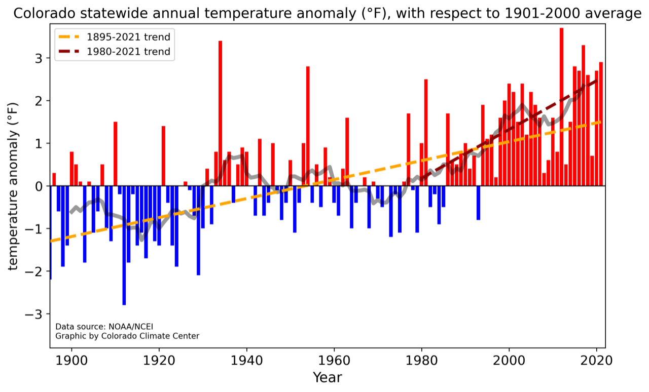
Grahic credit: Colorado Climate Center
Colorado has warmed about 2.5 degrees Fahrenheit in the last 120 years. Warming has accelerated, with the five hottest summers on record occurring since 2000.
Higher temperatures impact the amount of snowfall and amount of snowpack converted to water runoff. “As the climate warms, crops and forested ecosystems alike use water more rapidly,” says Peter Goble, a research associate at the Colorado Climate Center. “As a result, a higher fraction of our precipitation goes into feeding thirsty soils and a lower fraction into filling our lakes, streams and reservoirs. Essentially, a warmer future is a drier future.”
This year was a good example of the drying trend.
Dolores River watershed
Snowpack was around average in the San Juan Mountains, but spring arrived hot and windy. Snow was all but gone by late May, surpassed in its hurried departure only in 2018 and 2002. Farmers dependent on water from the Dolores River, still reeling from last year’s meager supplies, were required to accept lesser supplies yet again as the growing season began this year.
The Ute Mountain Ute Farm and Ranch Enterprise, the most southwesterly agriculture operation in Colorado, expected less than 30% of its regular water delivery from McPhee Reservoir. This was on top of a marginal year in 2021, too. Simon Martinez, general manager of the operation, said just 15 of the 110 center pivots had crops under cultivation in early June. Employment was cut in half, and the 650-head cow-calf operation had been slimmed to 570.
Pressured by compacts
The warming climate is not alone in spurring adaptations. In many river basins, irrigators must also worry about delivery of water to downstream states specified by interstate compacts.
Water conservation districts formed in the last 20 years are paying farmers to decrease pumping and planting to save the water that remains in the aquifers, comply with compacts, and transition to less water use.
Directors of the Republican River Water Conservation District, in northeastern Colorado were successful in voluntarily retiring 4,000 acres by June 2020. They are confident about retiring 10,000 acres in the area between Wray and Burlington before 2025. They’re less sure of achieving the 25,000 acres that compact compliance will require by 2029.
Rio Grande Water Conservation District directors in south-central Colorado have an even greater lift. They must figure out how to retire 40,000 irrigated acres by 2029. They’re at 13,000.
High commodity prices have discouraged farmer participation. The pot of local, state and federal money hasn’t been sufficient to fund high enough incentives to compete with commodity pricing. A bill, SB22-028, Groundwater Compact Compliance Fund, which passed in the Colorado Legislature in May, will allocate $60 million to both the Republican and Rio Grande basins to help them comply with interstate river compacts by reducing the acreage outlined above. The law says that if voluntary reductions cannot be attained, Colorado may resort to mandatory reductions in groundwater extraction.
From Sprinklers to New Crops
Even as center-pivot sprinklers are removed in the Republican River Basin and San Luis Valley, they are going up in the Grand Valley of western Colorado. There, instead of drafting groundwater, they are distributing Colorado River water, because they are reducing labor costs and reducing water use.
The geography of the valley from Palisade to Fruita and Loma does not immediately favor center pivots. They work best as a pie within a square, a full 40 or 160 acres. Parcels in the Grand Valley tend to be more rectangular. That means a pivot can arc maybe three-quarters of a circle. That slows the payoff on investment.
Why the pivot, so to speak, on pivots? Perry Cabot, a water resource specialist with Colorado State University’s Western Colorado Research Center near Fruita, sees two, sometimes overlapping, motivations. (Cabot also serves on the Water Education Colorado Board of Trustees.)
The greater motivation is the desire to save labor. That itself is good, he says, because the investment reflects an intention to continue farming. “People are obviously doing it for the long haul,” he says.
The other motivation appears to be water related. “The feedback I get is, to paraphrase the farmers, at some point in the future we are going to have less water to farm with and so we must prepare for that,” Cabot says.
Incremental improvements have improved efficiency. Experiments at the CSU research center in Walsh have shown conclusively the advantage of long-drop nozzles that spray the water just a couple feet off the ground, reducing evaporation.
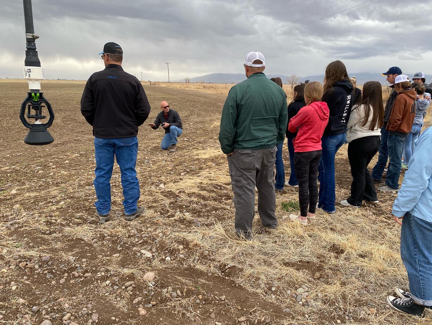
Jason Lorenz with Agro Engineering talks about irrigation, soil moisture and chemistry during a soil workshop for students in Colorado’s San Luis Valley.Courtesy of AgroEngineering
Technology can help perfect a producer’s irrigation set up. Consider work in the San Luis Valley by Agro Engineering, crop consultants who seek to assist growers in producing maximum value with minimum water application. Potatoes, the valley’s largest cash crop, thrive in warm, but not hot, days and cool nights. They need 16 to 18 inches of water per year, of which 13 to 15 inches comes from irrigation. This includes two inches applied during planting, to moisten soils sufficiently for germination. They do not do well with too much water, explains Jason Lorenz, an agricultural engineer who is a partner in the firm. That, and the need to align use with legal requirements, gives growers compelling reason to closely monitor water.
The company uses aerial surveys conducted from airplanes to analyze whether the desired uniformity is being achieved. The latest advancement, multispectral aerial photography, enables the detection of green, red and near-infrared light levels. These images indicate the amount of vegetative biomass, vegetative vigor, and the greenness of the leaves. Variations show where crops are healthier and where there are problems, including insects and diseases, water quality, or soil chemistry problems.
Any discussion of water and agriculture in Colorado must include a focus on corn. In 2021, according to the U.S. Department of Agriculture, almost 1.4 million acres in the state were devoted to corn, with well more than half of that irrigated.
Corn is also thirsty. So far, efforts to produce corn with less water have come up short, says Colorado State University water resources specialist Joel Schneekloth. But if corn still needs the same amount of water, researchers have succeeded in producing greater yields.
How about alternatives to corn? Sunflowers, used to make cooking oil but also for confections, came on strong, but acreage shrank from 132,000 acres to 59,000 acres statewide between 2010 and 2019. For farmers, corn pays far better.
Quinoa may be possible. It consumes less water. But no evidence has emerged that it’s viable in eastern Colorado. The demand is small. Demand also remains small for black-eyed peas, which a bean processing facility in Sterling accepts along with pinto, navy and other beans.
“We can find low-water crops, but they just don’t have huge markets,” explains Schneekloth who conducts studies for the Republican and South Platte basins at a research station in Akron. There has to be enough production to justify processing facilities, he said. One such processing facility proximate to the Ogallala aquifer in Colorado—it was in Goodland, Kansas—closed because it didn’t have enough business.
Nearly all of the corn in Colorado is grown to feed livestock. What if, instead of eating beef or pork, we ate plant-based substitutes? The shift, says Schneekloth, would save water. It takes seven pounds of forage and grain to produce one pound of meat. For a meat substitute, it’s closer to one for one. But that tradeoff isn’t that simple in most places. Much of the cattle raised in Colorado start on rangeland, feeding off of unirrigated forage, which is not suitable for crop production.
Besides, Schneekloth says he has a hard time imagining a mass migration to meat substitutes in the near future. Plant-based substitutes cost far more and the product, to many people, remains unsatisfactory. “Mass migration will be a hard one to sell,” he says. “Maybe eventually, but it won’t happen for a long time, I don’t think.”
Healthier Soils
Soil health has emerged as a lively new frontier of research and practice and the integration of livestock and crop production is one of its tenets—manure adds nutrients to the soil and builds organic matter, improving soil health.
Soil, unlike dirt, is alive. It’s full of organisms, necessary for growing plants. Wiggling worms demonstrate fecund soil, but most networking occurs on the microscopic level. This organic matter is rich with fungi and bacteria. Iowa’s rich soils have organic content of up to 9%. The native soils of Colorado’s Eastern Plains might have originally had 5%. The farms of southeastern Colorado now have 1% to 3%.
Derek Heckman is on a quest to boost the organic matter of his soil to 5% or even higher. It matters because water matters entirely on the 500 acres he farms in southeastern Colorado, just west of Lamar.
Derek Heckman, who farms near Lamar in eastern Colorado, is implementing various soil health practices to build the organic matter of his soil, improve water retention, and stretch limited water supplies farther.Allen Best
“Water is the limiting factor for our farms a majority of the time,” he explains. “We are never able to put on enough water.”
Heckman’s water comes from the Fort Lyon Canal, which takes out from the Arkansas River near La Junta. In a good year, he says, his land can get 25 to 30 runs from the ditch. Last year he got 16 runs. This year? As of early May, Heckman was expecting no more than 10 runs.
“The more organic matter there is, the more the moisture-holding capacity of the soil,” he explains. This is particularly important as water supplies dwindle during the hot days of summer.
“Let’s say we have 105 degrees every day for two weeks,” says Heckman. “Organic content of your soil of 3% might allow you to go four additional days without irrigation and without having potential yield loss or, even worse, crops loss.”
Heckman, 31, practices regenerative agriculture.
In explaining this, Heckman shies away from the word sustainable. It’s too limiting, he says. “I don’t want to just sustain what I’m doing. Regenerative is bringing the soil back to life.”
Growing corn in the traditional way involved plowing fields before planting. The working of the field might involve five passes by a tractor, compacting the soil and reducing its porosity. The plows disrupt microbial life.
For several decades, farmers and scientists have been exploring the benefits of less intrusive tilling of the soil. Beginning about 20 years ago, Heckman’s father was one of them. The scientific literature is becoming robust on the benefits of what is generically called “conservation tillage.”
Irrigated corn fields of eastern Colorado can require 10% less irrigation water depending upon tillage and residue management practices, according to a 2020 paper published by Schneekloth and others.
Heckman experiments continuously, trying to find the best balance of cover crops, minimal tilling, and the right mix of chemicals.
“A lot of guys are comfortable with what grandpa did and what dad did, and that’s what they do,” he says. “I want to see changes in our operation.”
On the Western Slope, soil health restoration is being tested in an experiment on sagebrush-dominated rangelands south of Montrose. Ken Holsinger, an ecologist with the U.S. Bureau of Land Management, says the intent is to restore diversity to the lands and improve the water-holding capacity of the soil.
Holsinger says the federal land was likely harmed by improper livestock grazing, particularly prior to adoption of the Taylor Grazing Act in 1934, but may well have continued until the 1970s prior to implementing modern grazing practices.
This experiment consists of a pair of one-acre plots that have lost their topsoil and have become dominated by sagebrush and invasive vegetation. Such lands produce 200 to 300 pounds of forage per acre but should be producing 800 to 1,000 pounds per acre of native grasses. The soil will be amended with nutrients to restart the carbon cycle. Afterward, 50% of the sagebrush will be removed.
“We are looking at restarting the carbon cycle and ultimately holding more water in the soil profile,” says Holsinger.
One way these enhanced, restored soils help is by preventing the monsoonal rains that western Colorado typically gets in summer from washing soil into creeks and rivers, muddying the water. If the experiment proves successful, then the task will be to cost-effectively scale it up, ideally to the watershed level.
Back in Silt, at the site of Spring Born, Charles Barr, the company’s owner, speaks to the need for innovation. “That will be the model going forward for all of these agricultural areas,” he says. “They have to find new sources of revenue, they have to find new ways of doing business, and they have to find new ways to conserve water.”
An earlier version of this article appeared in the Summer 2022 edition of Headwaters magazine.
Allen Best grew up in eastern Colorado, where both sets of grandparents were farmers. Best writes about the energy transition in Colorado and beyond at BigPivots.com.
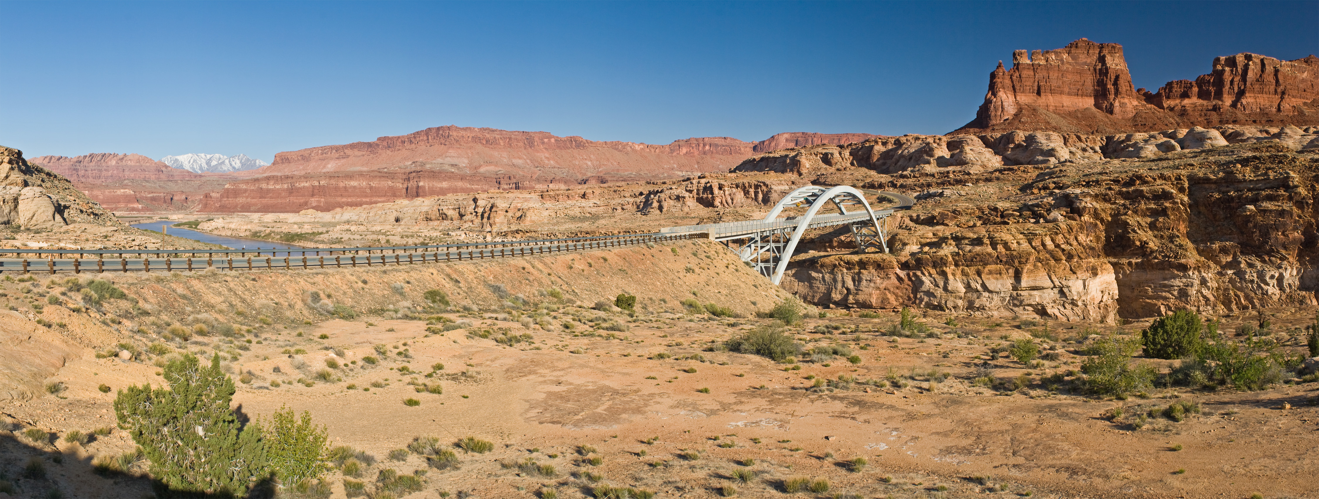
The Colorado River bridge on the Utah State Route 95 at Hite, Utah. Panorama stitched from 7 portrait format images. Photo credit: Christian Mehlführer via Wikimedia Commons
The Biden administration has given Western states a deadline to tackle the escalating emergency.
The Colorado River’s literal race to the bottom hit another low last month.
As the waterline dropped farther and shortages hit dire new levels, the Biden administration announced unprecedented cuts, giving Colorado and six other Western states 60 days to reach an agreement on how to radically reduce their water use.
There is good reason for such urgency. Last month, the U.S. Bureau of Reclamation imposed the first-ever Tier 2 water restrictions — a “break glass” emergency measure that was unthinkable even a few years ago.
The latest stark cuts mean that Arizona, Nevada and Mexico next year will see their shares of Colorado River water drop by 21%, 8% and 7%, respectively. And there are likely even more grueling restrictions ahead.
“People need to understand how important the Colorado River is for all of us,” said Elizabeth McVicker, Ph.D., J.D., a Management professor at Metropolitan State University of Denver who was instrumental in creating the One World One Water Center (OWOW). “It provides drinking water for 40 million people across seven states, fuels many major cities and generates electricity for 5 million households. If it fails, we all fail.”
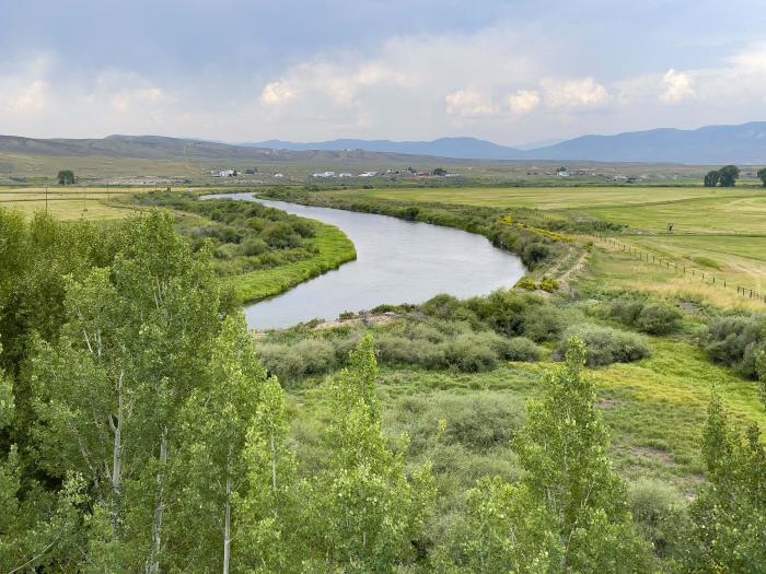
The Colorado River meanders through ranch land near Kremmling on Aug. 17, 2021. Choked by chronic overuse, a 22-year drought and the effects of climate change, the Colorado River’s flow has declined by nearly 20% this century. Photo credit: Denver Water.
Standoff among states
The crux of the current problem? Neither Upper Basin states (Colorado, Wyoming, Utah and New Mexico) nor Lower Basin states (California, Nevada and Arizona) want to make further water cuts — they each think the other side should make more sacrifices.
In essence, they are like seven people arguing over who gets the biggest bite of an ice-cream sandwich as it melts away before them.
However, McVicker sees glimmers of light. “Personally, I’m optimistic that the states will ultimately make progress because there’s a growing awareness that without serious action, we’ll all lose,” she said.
(Left to right) John McClow, Rebecca Mitchell, Gene Shawcroft, Tom Bucshatzke at the Colorado Water Congress 2022 Annual Summer Conference. Photo credit: Heather Sackett/Aspen Journalism
Unsurprisingly, she points out, state politicians are rattling their sabres and fighting their respective corners. “But we are seeing more meaningful collaboration between on-the-ground water agencies,” she added, “and that’s what counts.”
Climate consequences
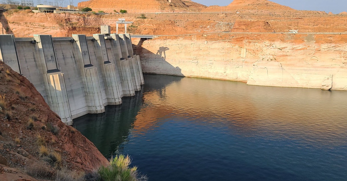
It’s no mystery how we got here. The U.S. is caught up in a historic 23-year megadrought. Our mountain snowpack is rapidly diminishing. Extreme heat is evaporating more water off the top of the great reservoirs. And unprecedented signs of depletion are seemingly everywhere.
Around the Lake Powell reservoir, a white “bathtub ring” outlines the recent steep water loss.
At Lake Mead, once-sunken boats have risen from the depths like ghoulish tombstones. Last month, receding waters in Texas revealed 113 million-year-old dinosaur tracks.
“We reached this point much more quickly than anyone thought,” McVicker conceded. “Most people thought it would be several more years before we reached Tier 2 status, but then it came along all at once.”
Students with answers
The urgency of the U.S. water shortage has long been recognized at MSU Denver, which runs a range of pioneering water-studies courses, including via the OWOW Center and a noncredit option via Innovative and Lifelong Learning. And many MSU Denver students are rolling up their sleeves to tackle an issue that will likely be around for their entire adult lives.
MSU Denver Computer Science major Victor Lemus Gomez presented a policy to lawmakers that proposed water loss audits as a way to plan for the future. Photo by Alyson McClaran
This summer, Victor Lemus Gomez took part in a Colorado fellowship program designed to give policymaking experience to STEM students. He created a proposal urging water providers to conduct water-loss audits, which would help state leaders plan better for the future. And the best part? He got to deliver it personally.
“It was such a privilege to present my policy proposal directly to lawmakers,” he said. “It gave me a firsthand look at the hard work and urgency that our state elected officials bring to this fight.”
Also in the fellowship program was fellow student Claire Sanford, who focused her efforts on water-wise landscaping. “It’s so important for water conservation,” she said. “Using native plants empowers people to tackle climate change while simultaneously lowering their water bills and encouraging biodiversity.”
Equally important, she said, it gives Coloradans a chance to connect with beautiful native landscapes that flourished in these same spaces centuries ago. “It’s always exciting to see people interacting with regionally appropriate plant life,” she said, “and it makes me feel hopeful for the future.”
Water waste
Tackling this imminent crisis will necessarily mean improving the efficiency of U.S. agriculture, which accounts for 80% of the Colorado River’s water use. But that’s a tall order, given that there is so much waste, leakage and, sometimes, plain poor judgment.
“Right now, our desert-based farmers are using billions of gallons of American water to grow crops such as cotton and hay for export to competitor countries like Saudi Arabia and China,” McVicker said. “Where is the sense in that?” The whole agricultural industry, she argues, needs to take a strong look at itself.
MSU Denver Environmental Science major, Claire Stanford, observes native plants and water wise landscaping at Botanical Gardens in Denver. Photo by Alyson McClaran
For a better example of how to do things, McVicker points to Aurora, where a new city proposal seeks to eliminate “nonfunctional turf” in almost all new developments, including residential lawns, medians and commercial properties. “They are taking real, concrete action and standing up for the simple idea that we have to preserve to thrive,” she said.
Persuading Coloradans to adopt a more responsible approach is also at the core of Sanford’s fellowship work. “People are awestruck when I show them how our native plants have complex root systems up to 5 feet deep, as opposed to the shallow Kentucky bluegrass,” she said. “These plants are literally rooted in our tradition, so we should be using them much more.”
One positive side effect of the ongoing crisis has been that the water industry is growing fast and increasingly becoming a realistic career choice for students. Smitten by the water bug himself, Gomez is encouraging others to explore potential opportunities in this fascinating field.
“Water is one of those critical elements that encompasses every aspect of our lives,” he said. “And the great courses at MSU Denver offer a pathway into a field of study that isn’t just fascinating and rewarding — it can also bring about real social change.”
John Tracy is the current director of the Colorado Water Center, and has previously served as the director of the Texas Water Resources Institute.
The U.S. Bureau of Reclamation announced Tuesday that two states plus Mexico will have a reduced supply of water for 2023 as the Colorado River basin enters a Tier 2 shortage for the first time in its recorded history.
The effort to conserve water comes as water levels in two of the river’s largest reservoirs – Lake Mead and Lake Powell – reach historic lows, stoking concerns about their respective dams’ ability to provide power. Meanwhile, roughly 40 million people in seven states rely on the Colorado River for water.
The latest federal restrictions come after the states that use the Colorado River failed to reach an agreement about how to reduce consumption in the long-term. Those conversations will continue – and could lead to changes to the 100-year-old Colorado River Compact.
“We’re almost to the breaking point where someone will have to suggest that the compact needs to be looked at, or all the states involved will have to decide, ‘we need to adjust our water usage every year because there’s no more water coming down the basin,’” said John Tracy, the director of the Colorado Water Center. “That’s the reality.”
He spoke to SOURCE about what the latest restrictions mean, what will happen next and Colorado State University’s role in researching water in the West. Read the full Q&A below:
What’s the significance of the Bureau of Reclamation declaring the current situation on the Colorado River a Tier 2 shortage, and why should we care?
There are a lot of different economies on the Colorado River that have been predicated on diverting water and carrying it long distances to cities, industries and agricultural production facilities. That’s been going on for 100 years.
If all of a sudden that water were shut off, it would be bad news for the region’s water supply. The most obvious city in that basin that would be impacted is Las Vegas, but there are other communities that would also have problems.
Being able to have certainty about how much water is available allows a wide range of communities and economic centers to prepare and work to allocate water resources between cities and for industries.
On top of that, the Colorado River is a huge power producer, so making sure the hydroelectric turbines keep flowing in the basin is a big deal. If the water levels drop below a certain point and are unable to produce power, there are cities like Las Vegas that simply can’t operate.
The U.S. government is reducing the water supply for Nevada, Arizona and Mexico. What does the crisis mean for the state of Colorado?
This gets into an interesting question, because in the U.S., the Constitution leaves decisions on water management up to individual states. The Colorado River Compact set the rules for who gets water when.
Where the federal government became involved is with the dams, and the two really big ones on the Colorado River are the Hoover Dam and the Glen Canyon Dam. Both are downstream from Colorado, so the decisions about reductions in releases there won’t have much of an impact here.
The only thing that might have some impact are instances where individual diverters enter into voluntary agreements to let water go downstream.
What can the federal government do to fix the situation?
Reclamation only has the authority to manage the facilities that they own, and that’s the Colorado River reservoirs. They can’t tell a state or irrigation district what to do. They can enter into agreements with water users, or can reduce releases from their facilities, but they have no regulatory authority on individual water users.
That’s why it’s up to the states to negotiate, and the document the Bureau of Reclamation released on Tuesday essentially says, “we’re going to punt this to next year and hope for a wet winter.”
It’s not the major cutback that’s needed. Instead, it’s trying to bring the lower states back into the allocations that were originally agreed upon by the Colorado River Compact 100 years ago. The federal government is hoping to get people to live by the agreement, and is hoping for a wet winter that will make the situation less urgent.
With climate change and the record drought, is there time to wait for a wet winter?
It’s one of those situations where you look at it via basic numbers. In essence, the Colorado River Compact from 100 years ago was predicated on a whole lot more water being available in the river than what really exists.
Climate change has made this worse and the timing worse, and it’s something we’ll have to live with in the future. So, you either do something really big, dealing with multiple states and the politics and interest groups involved, or you do year-to-year adjustments and see what happens.
What happens if no action is taken?
The solution will put itself into place. Reclamation has an obligation to keep the hydropower going for the electric grid, and if we don’t have a good winter and the water levels continue to drop, they’ll be in a position where they’ll have to reduce flows to the lower states.
It will be up to the U.S. Bureau of Reclamation to choose to either reduce hydropower production or the allocations to the lower states, because there will be no water to allocate.
This year, the Bureau said, “we can manage, but we’re right on the cusp.” But if the situation worsens, no action will not be a possibility and decisions will have to be made.
How is the Colorado Water Center furthering the scientific understanding of what’s happening in the Colorado River Basin?
There are various elements to it. You have Senior Water and Climate Scientist Brad Udall researching the climate change impacts on the Colorado River and beyond, and he has been providing very insightful basic science to inform policy makers about what they’ll have to deal with.
He’s been very important in moving this discussion forward to the point that it’s clear a crisis is coming.
Senior Water Policy Scholar Jennifer Gimbel is working to educate people on the Colorado River, and not just the physical nature, but how it impacts the seven states that utilize it. She’s teaching a graduate-level seminar course (GRAD 592) this semester focusing on the Colorado River Basin.
Research Scientist and Extension Specialist Perry Cabot is calculating water usage, and specifically helping policy makers understand how much water is utilized by crops and how much returns to rivers. He’s been collaborating with a wide variety of scientists across the West.
The Colorado Water Center is also doing lots of work to help policy makers understand the physical situation of the Colorado River, the history of the Compact, the water use in the basin and the science behind the drought’s impact.
What we don’t do is get into the discussion of where any agreement should go. We’re at the point where something’s got to give, and it will be interesting to see what happens, but that’s up to the policy makers and federal agencies responsible for the river.
To put it succinctly, our role is understanding the science and making sure everybody’s educated on the science.
Colorado and San Juan River Endangered Species Program: Julie Stahli, U.S. Fish and Wildlife Service
This map shows the snowpack depth of Castle and Maroon valleys in spring 2019. The map was created with information from NASA’s Airborne Snow Observatory, which will help water managers make more accurate streamflow predictions. Jeffrey Deems/ASO, National Snow and Ice Data Center
Colorado Airborne Snow Measurement Group: Taylor Winchell, Denver Water
Water ‘22: Jayla Poppleton, Water Education Colorado
Denver Water crews dug up old lead service lines from customers’ homes for years of study that led to the utility’s Lead Reduction Program. Photo credit: Denver Water.
Eliminating Lead in School Drinking Water Facilities: Mike Beck, CO Water Quality Control Division
Winchell told the attendees that, “ASO is an extremely powerful #climate adaption tool.”
He’s right, stationarity is dead so Colorado needs to incorporate new strategies for measurement of snowpack and that is exactly what the ASO technology provides.
Colorado needs more reservoir storage and ways to manage urban growth in order protect its water supplies, prominent politicians said Tuesday at a major gathering of water officials in Steamboat Springs.
“Water is central to our livelihoods and its increasing scarcity is a challenge of the first order for everyone who calls the American West home,” said Joe O’Dea, a Republican challenging incumbent Democratic Sen. Michael Bennet for one of Colorado’s U.S. Senate seats.
O’Dea spoke, along with Bennet, Gov. Jared Polis, and republican gubernatorial candidate Heidi Ganahl at the Colorado Water Congress’s summer convention. The Colorado Water Congress is a statewide association that represents water districts, utilities, environmental groups and tribal communities.
“You can’t solve our problem without talking about storage. We know this region is getting drier and large-scale weather events are coming at unpredictable times,” O’Dea said. “That makes it all that more important to store water resources whenever they do appear.
“But we need a more rational process to approving them. Chatfield took the better part of 23 years to permit a single common sense project. Environmental review and public comment are central to good decision making, but they shouldn’t take decades,” O’Dea said.
O’Dea was referring to the successful effort to convert some of the space in the federally owned Chatfield Reservoir southwest of Denver for storage rather than simply flood control, which was its mission when it was built in the 1960s.
Gov. Jared Polis, too, pointed at climate change as a key driver that will shape how Colorado and other states manage their water supplies in the coming decades.
“Over the past two decades we have faced forces that threaten our access to water. The chronic, extreme drought, the changing nature of precipitation across the West. These pressures threaten water security, not just of our farms, cities and rivers, but the entire region,” Polis said.
“As a headwaters state, our resources flow to 18 states and Mexico. The entire region relies on Colorado to be a good steward. We’re proud of that responsibility and we take that responsibility very seriously,” he said.
To fulfill that responsibility within and outside the state’s borders, Polis called for more major investments in water sustainability, citing as an example the $60 million that Colorado lawmakers approved this year to fallow land in the Rio Grande and Republican River basins to improve aquifer health and ensure the state can meet its obligations to deliver water to New Mexico and Texas, which also rely on the Rio Grande, and Kansas, which relies on the Republican River.
“As we look to the future of our state, we need to understand the connectedness of water to the many challenges we face,” Polis said. “We are facing consistent growth in Colorado. But we can’t afford the water profile of exurban sprawl. We need to grow in a sustainable way,” he said, citing the need to develop more housing that reduces Coloradans’ per capita water use.
Republican gubernatorial candidate Heidi Ganahl also called for more water storage and promised to limit federal intervention in Colorado’s water affairs, including negotiations over how to reduce water use among the seven states that rely on the Colorado River. These include the Upper Basin states of Colorado, New Mexico, Utah and Wyoming, and the Lower Basin states of Arizona, California and Nevada.
“The Upper Basin states have done just fine working through water issues. But expanding water storage is a must … and we must go in a different direction [regarding federal permitting requirements],” Ganahl said, adding that she would push the federal government to streamline water project approval processes.
She also criticized the Colorado Water Plan, a multi-million dollar collaborative effort by the Colorado Water Conservation Board to ensure the states’ major river basins are able to plan for and secure the water they need. Ganahl said it was too expensive and bureaucratic and that the current work to update the plan, first approved in 2015, “misses the mark. As governor I would simply work to develop more water.”
Bennet urged the conference attendees to look ahead and continue the hard work that has already been done.
“The conditions are as dire as we’ve seen, and we have a very difficult negotiation in front of us,” he said. “The people in this room have stepped up and made sacrifices,” he said. “But we know temporary Band-Aids are not going to cut it. All parties have to live with what the Colorado River can provide. This is an opportunity to make decisions that will strengthen the West for the next 100 years and fulfill our responsibility to the next generation.”
Political pollster Floyd Ciruli said that so many candidates spoke at the water conference was an indicator of the national attention that Western water shortages are generating, and he gave the politicos credit for providing on-point suggestions for what could be done.
“All four of these candidates were ready for today,” Ciruli said. “All of them talked about water.”
Jerd Smith is editor of Fresh Water News. She can be reached at 720-398-6474, via email at jerd@wateredco.org or @jerd_smith.
Coyote Gulch on the Yampa River Core Trail August 24, 2022.
Day 1 included an introduction to the The Headwaters of the Colorado Project from Pat O’Toole, a rancher on the Little Snake River near the Colorado/Wyoming border. An interesting note: He irrigates from ditches that divert in both states.
East Troublesome Fire. Photo credit: Northern Water
The Pre-conference workshop on forest and watershed health was killer. So much good work is being done across Colorado but of course due to decades of neglect the watersheds are in terrible shape and prone to the massive wildfires we have witnessed since 2000.
It was cool to hear about efforts at mitigation and restoration. There was a palpable excitement about the funding bills passed by Congress and signed by President Biden (with nearly universal non-support by Republicans) in the last 14 months including the recent $4 billion that the USBR scored for aridification relief in the Colorado River Basin. Molly Pitts drove home the need for a thriving forest products industry as part of the solution but she pointed out the need for trained workers, saying that you don’t put an inexperienced worker into a million dollar piece of equipment and turn them loose on the forest.
Much of the afternoon was a chance for the politicians running in the November election. Michael Bennet, Jared Polis, Joe O’Dea, and Heidi Ganahl all spoke. The final act was an election analysis by Floyd Ciruli.
Here’s the link to the conference web page and the agenda. Here’s the link to the Twitter fest. Note that the conference tag I’m using, #cwc2022, is shared by others.
Click on the image to enlarge. Credit: The Nature Conservancy
The Yampa River Core Trail runs right through downtown Steamboat. Photo credit City of Steamboat Springs.
I’m at the Steamboat Grand gearing up for the conference. Click th link to go to the conference website. Here’s the agenda.
I wonder if we’ll be chatting about the Colorado River?
I rode the Yampa River Core Trail from my campsite W. of town. It is a delight and a great way to get going in the morning.
Brad Udall: Here’s the latest version of my 4-Panel plot thru Water Year (Oct-Sep) of 2021 of the Colorado River big reservoirs, natural flows, precipitation, and temperature. Data (PRISM) goes back or 1906 (or 1935 for reservoirs.) This updates previous work with @GreatLakesPeck.
Carbondale rancher Bill Fales says that in 47 years of ranching in the Roaring Fork Valley, he’s never sees hay production as dismal as in 2020. “I used to think that one of the advantages of ranching here is we had a really stable climate,” he says. Photo credit: Laurine Lasalle/Aspen Journalism
In July, Cold Mountain Ranch and the Colorado Water Trust penned an agreement they hope will improve the Crystal River’s streamflow in dry years. The contract compensates the Ranch owners, Bill Fales and Marj Perry, for adjusting the timing of their water diversions when late summer flows dip.
The Crystal River has its headwaters in the Maroon Bells-Snowmass Wilderness, but as the river descends through the wide pastures above the Town of Carbondale, more than 30 agricultural diversions, representing around 300 cubic feet per second (cfs) of water rights, pull water from the Crystal and its tributaries to irrigate around 4,800 acres of land. In drought years, which are becoming more frequent, sections of the Crystal River run dry.
Created by Imgur user Fejetlenfej , a geographer and GIS analyst with a ‘lifelong passion for beautiful maps,’ it highlights the massive expanse of river basins across the country – in particular, those which feed the Mississippi River, in pink.
“A river is like a circulatory system,” says Alyson Meyer Gould, staff attorney & policy director for the water trust, “if you have a point where the circulatory system doesn’t work, it can have negative effects both upstream and downstream.”
A 2016 report on the Crystal River found there are specific stretches of the lower Crystal River that are most impaired, primarily after major ditches divert water from the river and before their return flows rejoin the Crystal downstream. This change to the river’s hydrology can impact water temperature, habitat quality and habitat availability, diminishing the ecosystem.
Cold Mountain Ranch is right next to one such beleaguered section of the Crystal River. The property has been in Marj Perry’s family since 1924. A cow-calf operation, the ranch irrigates several hundred acres for pasture and hay, utilizes grazing permits on nearby public lands and leases pasture nearby. In a typical year, Fales flood irrigates from early May through early October, moving water via ditches around his property in a three-week cycle. Fales gets two cuttings of hay, and spring and fall pasture with their water rights.
Under the new six-year agreement with the Colorado Water Trust, when river flows dip to 40 cfs or below, Cold Mountain Ranch will decide whether to enact the diversion coordination agreement. The ranch will be paid a $5,000 signing bonus for entering the updated agreement, an acknowledgment of the time and effort required to negotiate such a contract.
In addition to the bonus, for each cfs per day — up to 20 days total per year in up to five years — that they don’t divert during the contract period, they will be paid $250. The agreement will lift when flows hit 55 cfs. If the ranch is able to enact the agreement for their maximum decreed flow rate for the 100 potential days in the agreement, they could be paid $150,000 over five years.
Says Fales, “It’s the right thing to do. I’m not sure it’s a perfect thing to do, but I try not to let perfect be the enemy of the good. We’ll try it, we’ll see if it works and see what we learn from it.”
This is the second time that Cold Mountain Ranch and the Colorado Water Trust have entered such an agreement. The first ran from 2018 to 2020 but was never implemented. In 2018, flows in the Crystal were so low that “there was not enough water available to result in significant benefits instream,” according to the water trust. In 2019, flows were high enough that the threshold was never met. In 2020, heat and drought meant the ranch couldn’t afford to give up any water and still grow the hay and pasture they needed to feed their cows.
Helms Ditch irrigated acreage. Credit: Colorado Water Trust via Aspen Journalism
The water for this agreement will come from the Helms Ditch, which can divert up to around 6 cfs. In late summer this can be about 30% of the ranch’s available water. About half those rights were adjudicated in 1903 and the other half in 1936, making the diversion significantly more senior than the environmental instream flows on the river, which date to the 1970s. Cold Mountain Ranch uses water from three ditches, but the Helms Ditch is not shared with any neighbors, which makes it an easier candidate for an agreement with the water trust.
Crystal River rancher Bill Fales stands at the headgate for the Helms Ditch, with Mount Sopris in the background. As part of an agreement with the Colorado Water Trust, Fales could be paid to reduce his diversions from the ditch when the river is low. CREDIT: HEATHER SACKETT/ASPEN JOURNALISM
One barrier to in-stream water conservation is the fact that water voluntarily left in the river can simply be diverted by another user downstream. In this case, the agreement is designed to alleviate drought stress on a concise stretch of stream, an area that in the dry year of 2012 was completely dewatered. If the water stays in the river for as little as a mile or two, it can make a big difference. As Heather Tattersall Lewin, director of science and policy at the Roaring Fork Conservancy explains, “As little as 6 cfs can make a difference in temperature resiliency, the existence of a cool pool versus a shallow riffle, or the ability for a fish to move from pool to pool or not.”
This agreement with Cold Mountain Ranch is not the only one of its kind for the Colorado Water Trust. In 2012, when much of the state was in a severe drought, there were insufficient laws in place to protect water users who wanted to conserve. In 2013, the Colorado Legislature passed Senate Bill 13-19, allowing some water users to temporarily reduce their water use without jeopardizing their legal rights. Without that protection, a water user who conserved could legally be considered to be abandoning their valuable rights to water, a rule often referred to as “use it or lose it.”
Willow Creek via the USGS
Senate Bill 13-019 was first used by the Colorado Water Trust and a rancher on Willow Creek in 2016. Willow Creek is a tributary of the Colorado River southwest of Rocky Mountain National Park. The rancher had noticed Willow Creek sometimes ran dry during the late summer months and reached out to the water trust. That agreement has been used to restore flows in 2016, 2021 and 2022. According to the water trust, “The project restores a fairly small amount of water to the stream, but because there are no other diverters immediately downstream, that additional water helps to keep Willow Creek connected to the Colorado River.” This style of agreement has since been drawn up by the water trust for four other projects, including Cold Mountain Ranch.
Climate change is impacting both the supply and timing of flows in streams like the Crystal River. Average peak runoff is moving to earlier in the season, extending the amount of time in late summer when streams run low. Warmer temperatures make the soil thirstier, so more snowmelt gets absorbed by the land instead of turning into runoff, even when snowpacks are typical, increasing the frequency of low-flow years.
“The Colorado Water Trust sees diversion agreements as one of many tools in the toolbox to improve flows in Colorado Rivers in the face of climate change,” says Blake Mamich, water transactions coordinator for the water trust.
For some water users, dry years will make changing their diversions more challenging — many agricultural water users on the Crystal River and its tributaries already experience water shortages in dry years. But, continues Mamich, “these agreements may be advantageous to agricultural producers in sub-optimal production years, as a way to diversify income while supporting the health of the river.”
Agriculture represents the majority of water use in Colorado, so ranchers and farmers will need to be part of any major water conservation strategy. But it’s not as simple as just buying agricultural water rights. Farms and ranches around the state are a significant part of the state’s economy and lifestyle — permanently drying them up can have profound negative effects on local communities.
That’s why the water trust is trying these voluntary and temporary agreements, hoping to find a solution that benefits both the environment and agriculture. But, in the quest to improve flows around the state, the water trust uses many statutory tools to get more water in rivers, including purchasing and leasing water rights, creating agreements around the timing of reservoir releases, and more.
The Crystal River widens and becomes shallower just before it passes under the southern bridge into River Valley Ranch. A group of local organizations is working to restore both the stream and the banks. CREDIT: WILL GRANDBOIS / ASPEN JOURNALISM
For the Crystal River, water from Cold Mountain Ranch is just a start. The Crystal River Management Plan cites a need for 25 cfs during severe drought to meet goals for maintaining the ecosystem. The agreement between the water trust and the ranch will, at most, contribute 6 cfs for just 20 days of the year. To continue to build the river’s resilience in the face of climate change, Mamich says it will likely take a combination of various tools, from new infrastructure to additional diversion agreements with more water rights holders in the watershed.
Olivia Emmer is a freelance journalist based in Carbondale, Colorado. She can be reached at olivia@soprissun.com.
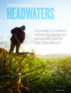
Back in the spring, we spoke with Nicholas Colglazier, a member of the Water Education Colorado Board of Trustees and executive director of the Colorado Corn Administrative Committee (CCAC), for the Summer 2022 issue of Headwaters magazine “How Are Colorado Farms and Ranches Managing Water For Tomorrow?” about the challenges facing corn growers and the organization’s work to promote water efficiency improvement measures.
CCAC is the state check-off for corn producers in Colorado, established back in 1987 through a market order to collect a 1.8 cents per bushel assessment on all grain corn grown in Colorado. CCAC uses that funding to conduct research, market development, promotion, outreach and education. That work includes sharing opportunities related to water efficiency soil health and more.
What does your water-related research and work look like?
We’re really looking at how do we help our producers be more efficient? How do we help producers operate with better management practices or best management practices?
And so a lot of that has actually been focused on water in the past. A lot of it has focused on variable rate irrigation or variable rate sprinklers. We’re also looking at, if you’re short on water, when should you irrigate to get the best yield for your crop? So we put some research dollars into that.
We’re really very much invested in how we use this scarce and very important resource efficiently and for the betterment of our industry and environment.
The latest thing we’re doing is we have really dove into soil health because what we see in terms of agriculture is a need for resilience especially as we see the climate changing, whether it’s getting hotter or drier or just hotter will be borne out in the future. But regardless, to be successful you have to be able to manage water and one of those ways is through soil health.
This monitoring station is part of a research project by Colorado State University to track soil and plant conditions in irrigated pastures. The study aims to learn more about how using less water affects high-elevation fields. CREDIT: HEATHER SACKETT/ASPEN JOURNALISM
What does soil health mean for producers?
If you can improve your soil health, whether it be through soil structure, organic matter, minimizing erosion from water as well as wind, you build a healthy foundation that you have as an agriculturalist to really be able to make it through harder times.
If you’re able to store more water in your soil, that means that you’ll have a better chance of making a crop in a hotter, dryer year.
If you have better soil structure that means that you have a higher infiltration rate. So when we get a hard rain, which we are notorious for here in Colorado—you know, getting 4 inches of rain in a couple of hours—your field has a better chance of actually absorbing and taking that water into the soil rather than letting it run off and provide no benefit for the future crops.
So we’re really investing heavily with the Colorado Department of Agriculture. We’re part of their soil health initiative and we’re trying to help farmers adopt those conservation practices that will lead to healthier soil and lead to better water retention. And a lot people recognize that this is really what we’re after water retention and healthier soil, so that we can better manage that water here and for future crops.
How are you communicating the importance of soil health out to corn growers?
What we’re trying to do is enroll about seven producers in the STAR+ program. STAR stands for Saving Tomorrow’s Agricultural Resources and it basically awards producers a star level depending upon their practices. So if you are minimizing soil disturbance, if you are building soil armor, if you’re incorporating livestock, if you have plant diversity, if you have a continual live root, these are all things we look for to increase soil health and the microbiome within it. If you’re doing this, you get awarded points.
It’s not like a test where you get answers wrong and they take points away, it is literally an accumulation of points where they look at, “OK, what are you doing? Are you doing your best management practices? Are you adopting good conservation methods? Are you looking out for ways to lessen soil erosion? Are you looking out for ways to lessen your trips across the field and while you’re doing it, lessen the disturbance of that soil so that you can build that soil health?”
And that goes into everything, like soil structure, water infiltration rates, and managing that soil so it can better take in that water resource.
So we’ve been trying to get out there and get a few people to bite.
We have some monetary incentives because these things aren’t cost-free, it takes money to change these practices and buy new equipment, to buy new cover crop seed, you name it. It takes capital investment from our producers and if we can help offset that from the very beginning so that we can learn how things work on farms and get actual practical knowledge and practice on somebody’s farm, it helps flatten that learning curve for the future so that more and more people will be willing to adopt.
So we’re really trying to incentivize producers into this program so that we can get that data and help communicate further to producers to say, you know, doing this is not only beneficial to the environment but it’s beneficial for your bottom line and that sustainability tripod of economics, environment, and social benefits are all there. Without one of them, that whole sustainability table topples right over so were really big believers in that and moving that forward.
Farmers Highline Canal Arvada.
What are the biggest challenges that Colorado Corn growers are up against today?
I’d say first and foremost is water availability.
We look at what’s going on, not only just soil health but also in terms of what water’s available and who’s out there buying it. We’ve seen a lot of agricultural operations dry up in the past and we’ve seen a lot of municipalities and people buy farms specifically for the water for later use. So the farm may be using that water now but what is it going to be like in 10, or 15 or 20 years? Are they going to keep that water on the farm or are they going to pull that off for municipal reasons? Keeping water available to farmers is definitely an issue that we see farmers facing down.
Making sure that people who have water have access to it is a big issue, but also making sure the resource is there for the longevity of the industry and community it supports.
Another one is profitability. That is always something that has been an issue within agriculture. It’s a pretty interesting time to talk about it because we’re seeing $8 corn on the board and I just looked at it today in Yuma you can contract, October and November, corn for $7.81 that’s a very, very high price for corn. But we’re also facing questions on the availability of fertilizers and pesticides that are needed to successfully grow a crop. And if you don’t have access to those tools, are you going to be able to grow a crop? Even with $7 corn.
Micha Ide of Bright Ide Acres farm, Washington, practices rotational grazing on her farm. Animals are moved frequently around the pasture to increase soil fertility and enhance the sustainability of the farm. Photo credit: Audra Mulkern
Another issue that we’re constantly trying to figure out is the sustainability of corn. We entered into the soil health arena with the department because we realized sustainability really is a big deal but it’s becoming a much bigger deal outside of our industry. Our customers are the ethanol plants and feed yards, they’re the ones who are selling, ultimately, to the consumer and the consumers are demanding more environmentally conscious sustainability in their products and their buying.
So, how can corn make sure we are on that path? That we’re providing a sustainable product to our consumers so to feed lots, to the ethanol plants, to the hog farms, to the chicken farms. How do we make sure that corn is sustainable?
It’s finding that message and delivering the fact that throughout the years we’ve been ahead of our time. Take 1980-2015, you know, we reduced erosion immensely, we’ve become much more efficient with our land use, we’ve become much more efficient with our water use, we reduced our gas footprint, but we’ve got to keep doing more.
We’re seeing companies like Mcdonald’s and Walmart come out with sustainability statements on row crops, so you know that at some point, those are going to take hold and it’s going to impact what we can and can’t do on our farms. Those producers who are able to adopt practices so they can meet those sustainability metrics are going to be successful. It’s going to impact the entire industry and how we do things.
So, making sure we keep that up, we are at the table when it comes to these sustainability discussions so we can look at a Walmart or a Mcdonald’s and, as they set their goals, we can say ‘Yeah, we can do that” or “you’re asking too much, that’s just not a feasibility.” There are limitations on what we can do and still allow profitability in the system. Because if you don’t have profitability in the system, you’re not going to have anybody there to do it.
Are most producers feeling the same pressure and push toward sustainability?
I don’t know if they are feeling it at the farm level just yet. A lot of them are probably looking at just figuring out “how do we make it through this year, how do we make it through next year?”
But a lot of them are looking at how do we become more sustainable in our operations? Maybe not because of what Walmart or Mcdonald’s are doing but because we need to become more sustainable. We realize that sustainability, the traditional definition of social, economic, environmental benefit, they’re trying to find a balance between all of those knowing that’s what they need to do for their own success in their operation. If they can find ways to impact the environment less, if they can find ways that build that soil, build that foundation, they’re going to be ultimately more successful. So I think a lot of them are looking in that direction versus what are customers’ customers demanding of them. And sometimes that’s coming from the top down.
Agriculture in Colorado is the state’s largest water diverter and user. But knowing that, ultimately, we’re doing that for consumers and we’re trying to do that in the most environmental and sustainable way possible. Being efficient, trying to conserve where we can, and doing this because ultimately, the food we grow whether it be corn for livestock or fruit and vegetables is consumed by consumers, who, most of them live in the Denver metro area. So, that relationship that everybody has to water and agriculture is there because every day, whether it’s a direct consumption of water through your faucet or consumption of water through the foods that they eat ultimately it comes back to us as a consumer when it comes to agriculture diverting water.
That’s why it’s so important to find ways to keep water in agriculture because that allows that food that we consume each and every day, for a lot of it to come from their backdoor, from their state, to not have to bring it across state lines or transport it thousands of miles, it allows them to support their farmers who are just in their backyard, out on the Eastern Plains or the Western Slope and it’s incredibly important that people realize that we’re all part of this water cycle and we’re all using that water.
Read about other ways in which Colorado’s farmers and ranchers are managing water with an eye toward efficiency and water quality improvements in the summer 2022 issue of Headwaters magazine “How Are Colorado Farms And Ranches Managing Water For Tomorrow?”
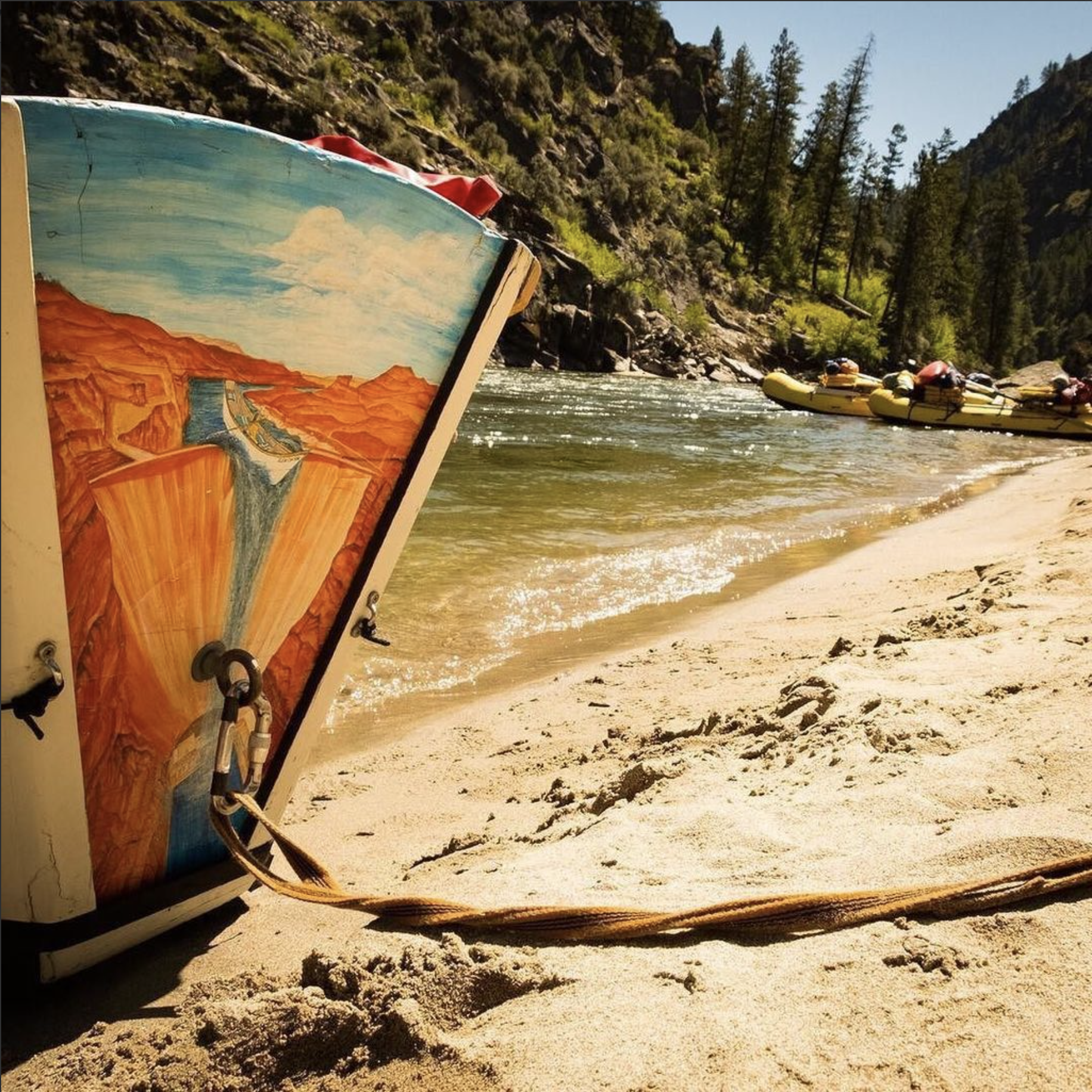
Here’s to weekends on wild rivers! And to cool boats that make a statement. There is no ride like a classic dory – and the Glen Canyon is a special boat. You must give this a try sometime if you haven’t already. So cool! @AmericanRivers
My family has been raising cattle in the Southwest for almost 50 years, and last year we experienced a first – producers in our valley did not receive any supplemental irrigation water from the reservoir. Agricultural producers in the river valleys and winding canyons of the Southwest are feeling the impacts of climate change. Temperatures are rising, snowpack is decreasing, runoff is occurring earlier in the year, and it’s becoming drier. As climate change continues to impact the Southwest, understanding how these environmental changes impact us will help farmers and ranchers like myself adjust our land management practices to remain resilient to drought and climate change.
Ecosystems Adapt & So Can We!
Areas that receive low amounts of rainfall are especially susceptible to changes in the environment. The plants and animals that live in dry areas are specialized to this unique landscape, and as the world around them changes, they must adapt or face extinction. Fortunately, healthy ecosystems respond to change, and so can we. The key to responding is diversity. Biodiversity is what gives species the genetic advantage they need to adapt to changing environments. The environment is changing, and just as genetic diversity allows for change, farmers and ranchers can proactively use innovative, versatile strategies to respond and help their enterprises survive.
Healthy Livestock Make Happy, Profitable Ranchers
Ensuring livestock remain healthy is the top priority for those who raise animals. Managed grazing that supports healthy soils and robust forage is a must. Lack of water affects the nutritional content and digestibility of forage. This leads to animals – and ranchers – becoming stressed. Adjusting stocking rates and pasture rotation are a few strategies recommended by the USDA Southwest Climate Hub that can help support the health of your pastures, which in turn supports the health of your animals.
Increased temperatures aren’t just uncomfortable; livestock consume more water when it is hot, making stock water especially important when water is scarce. Warmer temperatures also directly impact the health of our livestock, which in turn reduces profits. Providing access to pastures with trees or shade structures where livestock can get out of the sun is just as important as providing access to water.
It’s No Surprise That Plants Need Water
Photo courtesy of Sensa Wolcott
When water is limited, our fields produce less hay, forage and produce, making it challenging to grow what we need to be successful. Changing temperature will affect which crops thrive in particular areas. The Colorado State University Extension office provides many helpful strategies for how we can tackle these challenges. Prepare to make adjustments to the specific plants that you cultivate. Try planting crop varieties that require less water to thrive and research how specific crops use water. Rotate crops in a way that better promotes growth and productivity during drought and incorporate strategies that slow down water and increase infiltration, such as installing contour swales in fields.
Changes in temperature and precipitation patterns will impact the harvest timing of hay and produce and increase the likelihood of weeds popping up. Be prepared for changes in when you typically harvest and focus on increasing biodiversity by planting a mixture of different types of plants in a hayfield or pasture. Variety provides resilience as well as defense against invasive species, which are less likely to move into healthy, drought-resilient pastures and hayfields.
Healthy Watersheds Support Us All
Wetland. Photo courtesy of Sensa Wolcott
Water is critical to life in Colorado because it supports the biodiversity and health of the entire watershed, including the animals and plants so important to farmers and ranchers. Improving irrigation efficiency and upgrading diversion structures can help us adapt to rising temperatures that cause snow to melt and runoff earlier in the year. Early runoff means there is less water later in the season, when animals, plants, and irrigators all need water. Practicing irrigation strategies that encourage keeping rivers wet and implementing practices that increase groundwater storage support healthy waterways and support the needs of farmers and ranchers.
Riparian area management techniques like those mentioned in this article from Agri-Food Canada can benefit producers and the ecosystem. Try fencing livestock out of parts of the riparian corridor to support healthy riparian ecosystems. Livestock can cause erosion and water quality concerns – but well-planned access points that provide livestock with access to crucial drinking water can support both a healthy herd and a thriving waterway.
Farmers and ranchers want to see water in the river – the longer the better – which also supports the health and well-being of the aquatic ecosystem. Protecting our riparian areas is imperative; when our riparian corridors are healthy and thriving, so are we.
We Have a Choice
The future of agriculture is tied tightly to the future of our waters. Healthy ecosystems that have a variety of plants and animals are vital. Choosing innovative management strategies enables us to be good stewards of the natural world while also improving our farms and ranches so that we all can remain resilient in the face of drought and a changing climate.
Sensa Wolcottt.
Sensa Wolcott works as the Watershed Coordinator for the Mancos Conservation District. She is pursuing her Masters in Biology through Miami University’s Project Dragonfly, where her work focuses on community-based conservation and connecting people with the land through dialogue and collaboration. Sensa and her family live on their family owned and operated cattle ranch and enjoys hiking, camping, mountain biking, and photography.
Mancos and the Mesa Verde area from the La Plata Mountains.
They’re seeking opportunity, fairness, and a voice in decision making after a century of exclusion
Mid-morning in early September 2020, leaders from eight tribal nations met with Arizona state legislators, water engineers and policy experts via Zoom. One by one, each recounted their tribe’s history and efforts to secure water for their citizens. Half of the tribes in Arizona have unresolved claims to water. Of the 30 federally recognized sovereign tribal nations in the U.S. segment of Colorado River Basin, the vast majority, 22, are in Arizona.
Meeting that day was the Arizona Governor’s Water Augmentation, Innovation and Conservation Council, a committee of state legislators and water policy experts convened to plan for Arizona’s share of diminishing resources in the Colorado River Basin.
Not quite a year later, in August 2021, federal officials issued the first-ever shortage declaration on the river, resulting in substantial cuts to Arizona’s share of Colorado River water. The state has been working with some of the tribes with resolved, adjudicated water rights to help make up for low water levels.
On that September morning in 2020, two things had become clear: First, tribes like the Navajo Nation, Pascua Yaqui Tribe, and Yavapai-Apache Nation have found a couple of conditions in Arizona’s policy toward negotiating Indian water settlements unacceptable, thus their water rights remain unsettled. And second, tribal nations had been collaborative partners to surrounding communities and were, and continue to be, positioned to play an increasingly pivotal role throughout the basin as more tribal water rights are settled and basin-wide water supplies continue to decline.
Tribes have played a pivotal role in leasing water to support other water users and states as they cope with water shortage, for example. But with so many tribes who still have unsettled water rights and Colorado River flows declining, big questions remain for the 40 million people spread throughout the basin in seven U.S. States and Mexico—many of those questions center around the tribes.
Ticking Clock
Everyone in the basin can hear the clock, ominously dripping time like a leaky faucet. Drip: There is less water than ever before with the basin ensnared in a 22-year megadrought, the worst in the past 1,200 years, according to a recent study published in the journal Nature Climate Change. Drop: Without swift action to conserve water under the growing pressure of demand, the basin may be hurtling toward a water crisis. Drip: The basin’s existing water shortage management framework is set to expire in 2026 so negotiations to craft the next framework are underway; will tribal nations be included in those negotiations? Drop: How will water shortages affect the tribal nations in the Colorado River Basin and what role will those tribes play as all water users cope with shortage?
Generally, the Colorado River Basin’s tribes have some of the senior-most water rights on the river, based on federally “reserved” water rights with priority dates aligned with the dates reservations were established, some as early as 1865.
But even today, 12 of the basin’s tribes (most in Arizona) have unresolved water rights claims, and eight of those 12 have unquantified rights—meaning the amount of water they have a right to is not yet determined. Simply securing those water rights remains a time-consuming and arduous endeavor, in costly settlement negotiations amidst a scrum of other water users staking claims.
The water held by the basin tribes who have legally quantified water rights amounts to no small sum: 22 tribal nations retain 3.2 million acre-feet of water, or an estimated 22% to 26% of all annual water supplies in the basin, according to a 2021 brief from the Water and Tribes Initiative. This amount will likely increase over the years once more tribal water claims are resolved.
Even for tribes with settled or adjudicated water rights, some can’t access the full extent of that water because of lack of infrastructure or funding, or both. In total, just under half, or 1.5 million-acre-feet, of settled or adjudicated tribal rights have not yet been put to use by the tribes.
When adding together that unused water and unquantified water, and considering that tribes plan to fully develop and use their water, other water users in the basin wonder how it will look to integrate expanded tribal water use with existing water uses as water supplies continue to dwindle.
Lack of Representation
In one blinding instant, a flashbulb floods the adobe-walled room, illuminating a row of stoic men: seven state water commissioners standing behind then-Secretary of Commerce Herbert Hoover who sat at a desk. In front of them lies the 1922 Colorado River Compact, the formative agreement to carve up flows of the Colorado River. Within the Palace of the Governors in Santa Fe, N.M., these men divided the river into an upper and lower basin, apportioning the rights to consume 15 million acre-feet of water—their estimation of average annual river flow at the time—between the seven U.S. basin states: Colorado, New Mexico, Utah and Wyoming of the upper basin, and Arizona, California and Nevada of the lower basin, with the opportunity for lower basin states to develop an additional 1 million acre-feet from tributaries below Lee Ferry, Ariz.
The compact ushered in a new era of water management for the Colorado River Basin. But now, 100 years later, when facilitator of the Water and Tribes Initiative, Daryl Vigil, peers at this photograph of Hoover and the state water commissioners, he sees an “all monochromatic photo of older white gentlemen” who made no plan for apportioning any share of water to Native American tribes.
Herbert Hoover presides over the signing of the Colorado River Compact in November 1922. Members of the Colorado River Commission stood together at the signing of the Colorado River Compact on November 24, 1922. The signing took place at the Palace of the Governors in Santa Fe, New Mexico, with Secretary of Commerce Herbert Hoover presiding (seated). (Courtesy U.S. Department of Interior, Bureau of Reclamation)
Since the beginning of U.S. tribal water law, sovereign tribal nations in the basin have been excluded from cornerstone water management decisions despite having senior title to water. Native American water rights were first officially recognized in 1908, over a decade before the Colorado River Compact was signed, with the U.S. Supreme Court’s Winters v. United States decision. The court found that when the federal government “reserved” territories known as reservations, it too had “reserved” sufficient water to fulfill the purposes of the reservations—these water rights are considered established at the date when the reservation was created, making them senior to all uses that came later. But having the right to reserved water didn’t mean that the tribes had access to actual “wet” water or the legal representation to quantify their water rights.
When the 1922 compact was signed, tribes were surviving a multitude of disastrous living conditions and forced assimilation produced by federal Indian policy, established after U.S. violent colonial expansion. Indigenous peoples weren’t recognized as U.S. citizens until 1924, tribal governance wasn’t federally recognized until 1934, and Native Americans couldn’t vote in every state until the 1960s. “We were surviving here on government rations in 1922 when the Law of the River was created,” says Vigil.
A 1928 survey entitled “The Problem of Indian Administration” found that 26 Western Native American reservations and their economic bases were crumbling under management of the U.S. Department of the Interior (DOI), asserting that colonialism largely destroyed their ability to hunt, gather and fish.
The report recommended educating tribes to effectively use their land and water rights, saying that administrators “should be given the duty of seeing that the Indians secure their rightful share of water.” This recommendation was not enough. Assigning concrete legal title to tribal water succumbed to federal delay—a defining feature of water rights disputes for all tribal nations.
Tribes gained some ground when, in 1963, tribal water policy and Colorado River policy intersected in the U.S. Supreme Court’s Arizona v. California decision. Lengthy litigation led up to the decision, with Arizona filing suit in the U.S. Supreme Court to determine how much Colorado River water it could use. To answer that question, the U.S. found it had to assess what reserved water rights were needed for some of the tribes in the lower basin. A special master for the case determined the future needs of each reservation by assessing the amount of practicably irrigable acres and reserving water to irrigate that land rather than considering the reservations’ populations. In his proposed decree, which was upheld by the Supreme Court, the special master entered a quantified water right for five reservations on the mainstem of the Colorado River, granting 905,496 acre-feet of water for 135,636 irrigable acres.
After the case established the standard of quantifying the tribal reserved water right as looking at the amount of water required to irrigate the irrigable acreage on the tribal land, the push to quantify more tribal water rights ensued. But Supreme Court rulings “grew more negative,” according to a presentation from DOI. In 1989, DOI adopted the policy to resolve Indian water disputes through settlement rather than litigation, creating the Secretary’s Indian Water Rights Office. To reach agreement, Indigenous nations must negotiate their rights within a massive tangle of other users staking claims to water within the state where their reservation is located, which can take decades. Once all parties concur, Congress must approve the agreement by passing legislation to fund any tribal water infrastructure projects.
As federal tribal water policy evolved, so too did Colorado River policy. After the 1922 compact, a series of layered agreements—including Arizona v. California and other court decisions, congressional acts, legal settlements, treaties and compacts—known collectively as the “Law of the River” have come to govern the way water is managed and divided throughout the basin.
The latest layers of the Law of the River have been implemented since 2000, in response to years of drought. In 2007, the U.S. Secretary of the Interior adopted the Interim Guidelines for Lower Basin Shortages and Coordinated Operations for Lake Powell and Lake Mead. The Interim Guidelines outline a method to balance the amount of water available between the upper and lower basins. In 2019, upper and lower basin Drought Contingency Plans (DCPs) were developed as additional frameworks to address water shortages and water-saving rules.
The upper basin continues to “equalize” the contents of Lake Powell and Lake Mead per the 2007 guidelines, and continues to pursue water augmentation activities such as cloud seeding. It is also exploring the possibility of developing a demand management program in which water saved or not used in the upper basin could be stored in Powell as a 500,000 acre-foot drought pool, though the Colorado Water Conservation Board put a “hard pause” on Colorado’s demand management investigation in March 2022. For the lower basin, the DCP, a Binational Water Scarcity Contingency Plan with Mexico, and the 2007 guidelines lay out cuts in water deliveries from the Colorado River, triggered by projections of Lake Mead storage elevations. The interim guidelines already outlined cuts but the DCP added additional delivery reductions for the lower basin states and Mexico to absorb. The greatest cuts to lower basin water use will come from Arizona and California but the entire lower basin, including Mexico, will share in scarcity.
When these guidelines and plans were crafted, all but the Lower Basin DCP received little to no tribal input. These plans will expire in 2026, and negotiations for the next phase of shortage-sharing agreements are just beginning.
Native American Timeline. Credit: Water Education Colorado
Vigil, who is also water administrator for the Jicarilla Apache Nation from New Mexico, joined the Water and Tribes Initiative in 2017 to facilitate tribal discussions, protect water rights, and unify tribal interests within the Colorado River Basin. Their tribal leader forums helped spur a coalition of the tribes in the basin to call for inclusion in water framework negotiations.
When new guidelines are developed to govern river management beyond 2026, how will they affect existing tribal water rights or unresolved water claims? “Those are questions that are not yet clear to the Ute Mountain Ute Tribe and probably other tribes,” says Leland Begay, water attorney for the Ute Mountain Ute Tribe, which has adjudicated water rights in Colorado but has not yet resolved its water rights in New Mexico and Utah.
Settled Water Rights for the Colorado Ute Tribes
During the hot summers of his childhood, Lyndreth Wall of the Ute Mountain Ute Tribe would take refuge on Ute Mountain in southwestern Colorado, herding livestock at his grandparents’ sheep camp. They spoke only Ute to him, which he picked up fast, at least conversationally. In those days, the 1970s, the water on Ute Mountain was delicious. “The tribe took care of the water there,” Wall says. But his home tap water in Towaoc tasted like metal. It was “disgusting,” he says, and could make you sick. In White Mesa, their western tribal community in Utah, the water was worse—contaminated by radioactive waste.
For young Wall, his neighbors, family and livestock, the journey to procure drinkable water would be a 30- to 120-mile round trip excursion from Towaoc to Cortez or Mancos, even Durango, Colo. Wall remembers his parents packing buckets in their family pickup—the Wall’s buckets mixed with those of neighbors. This supply would last a few days before they would need more.
Today, more Ute Mountain Ute tribal members have water for drinking and irrigation thanks to the 1986 Colorado Ute Indian Water Rights Final Settlement Agreement, followed two years later by a federal settlement act, and by amendments in 2000, all of which they share with the Southern Ute Indian Tribe. The settlement places the Colorado Ute tribes among the four tribes in the upper Colorado River Basin that have completed water rights settlements, which also means that the State of Colorado is no longer negotiating any tribal settlement agreements.
For the Ute Mountain Ute Tribe, the settlement meant access to Dolores Project water, an entitlement to Animas-La Plata Project water, and rights to over 27,000 acre-feet of water from rivers that flow near or through their reservation. Most years, the Ute Mountain Ute Tribe can access their 25,100 acre-foot water storage allocation from the Dolores Project’s McPhee Reservoir in southwestern Colorado. Water from McPhee began to flow to the Ute Mountain Ute Tribe in 1994 delivering clean drinking water to the tribe for the first time in their history and supporting the development of a hotel, travel center and casino, which provide vital tribal employment and income. The tribe’s new irrigation water from the Dolores Project, up to 23,300 acre-feet per year, supported the development of the highly productive 7,700-acre Ute Mountain Ute Farm and Ranch Enterprise and Bow and Arrow corn mill.
For the Southern Ute Indian Tribe, the settlement wasn’t quite as momentous. “We have seven sources of water, seven rivers, that run to the tribe, so the tribe had been accessing those waters pre-settlement,” says Kathy Rall, head of the water resources division for the Southern Ute Indian Tribe. Before the settlement, the tribe didn’t have quantified rights to that water, Rall says. “Those rights were hammered out and solidified through the settlement,” she says. The Southern Ute Indian Tribe also received an allocation of Animas-La Plata Project water—but the infrastructure was never built for either tribe to access that water.
“Ever since [the Animas-La Plata Project] was constructed, we’ve never used a drop of it, yet we have a certain percentage, not only to us, but also our sister tribe, the Southern Ute,” says Wall, who is now a tribal councilman for the Ute Mountain Ute Tribe. The project allocated more than 60,000 acre-feet per year of municipal and industrial water to the Ute Mountain Ute Tribe and the Southern Ute Indian Tribe, but a series of obstacles has made this water inaccessible.
Lake Nighthorse and Durango March 2016 photo via Greg Hobbs.
The settlement authorized the construction of Lake Nighthorse, just south of Durango, to store Animas-La Plata water for tribal water uses. The project was envisioned to bring water for irrigation, municipal and industrial uses to the tribes and non-tribal water users. But environmental and fiscal concerns resulted in the project being downsized.
A lawsuit halted the construction of Lake Nighthorse’s Ridges Basin Dam in 1992. Groups including the Environmental Defense Fund, Sierra Club, and the Taxpayers for the Animas River argued the dam’s cost was an undue burden for taxpayers and that its construction would threaten the Colorado pikeminnow fish population, which was federally listed as endangered at the time. Christine Arbogast, lobbyist for the Ute Mountain Ute Tribe, Southern Ute Indian Tribe, and neighboring water districts and municipalities, remembers a meeting where an environmental advocate said that with the amount of funding required to build the reservoir project, they could supply the tribe with bottled water for life. “That was the kind of mentality on the side of the environmental community,” says Arbogast.
As project proponents tried to advance Lake Nighthorse, part of the permitting requirement was to propose alternatives to the project. To address the endangered fish issues, the U.S. Fish and Wildlife Service approved an alternative that would allow for reservoir construction but with certain requirements, including a new San Juan River Basin Recovery Implementation Program. The recovery program would go on to manage the river to recover the endangered Colorado pikeminnow and the razorback sucker while allowing water development to continue.
To carry out the Animas-La Plata Project, a 2000 settlement amendment restricted the water in Lake Nighthorse to municipal and industrial use, excluding irrigation. Now referred to as “Animas-La Plata Lite” there was no longer any plan to construct the irrigation canals that would have connected Lake Nighthorse to the tribes and even neighboring water districts and municipalities that were counting on these water supplies throughout the negotiations. The tribes scrapped their plans to expand farmlands as a result. “It was heartbreaking to every single one of them, including the tribes, when we had to make the decision to shelve the irrigation component in order to get this settlement,” Arbogast says.
Some positive outcomes resulted from the settlement, including quantified and adjudicated water rights for the Southern Ute Indian Tribe, access to Dolores Project water for the Ute Mountain Ute Tribe, and funding for both tribes, Rall says. But ongoing lack of access to water stored in Lake Nighthorse and the inability to use that water, if accessed, for irrigation, was “disastrous” she says.
When the project was downsized to the “lite” version “we just kind of said, ‘OK, we’re going to get what we get,’” Rall says. “The tribe went, ‘If we don’t settle now, who knows what we’ll end up with.’”
The settlement means that the tribes’ water allocations are protected, which “does offer the tribes a measure of security in their water rights,” says Amy Ostdiek, head of the Colorado Water Conservation Board’s Interstate and Federal Section. “But there are still critical needs in terms of infrastructure and access to clean drinking water.”
As the settlement stipulates, the moment the tribes begin to use water from Lake Nighthorse, they will each inherit an annual bill of around $800,000 in operations and maintenance costs for the dam and pumping facilities that the federal government is currently footing. At the moment, there is still no infrastructure to deliver the water to the tribes, and the tribes are not prepared to take on those costs, so they haven’t used any of their water. This may change due to the $2.5 billion earmarked in the 2021 Infrastructure Investment and Jobs Act for completion of authorized Indian water rights settlements. Both Colorado Ute tribes are pursuing that funding, with full support from the State of Colorado, according to the Colorado Water Conservation Board (CWCB), but whether they will receive it remains to be seen. Information sessions on the bill between tribal nations and DOI are ongoing.
“We’re trying to find alternatives and ways that we can utilize our water in [Lake] Nighthorse. We want it and it seems like we’re having a water war,” says Wall. “What’s rightfully ours is ours by God. We need to continue to save it for the future of our tribe.”
Water or Land, Not Both
Settling and quantifying tribal water rights claims isn’t just beneficial to tribal nations. The state in which a reservation is located and other water users there benefit from the certainty of knowing how much water is allocated to the tribes so they can make plans to live within and stretch their own share or to work together to send water where it’s most needed.
But Arizona is home, at least partially, to 11 of the 12 tribal nations in the basin who still have unresolved claims to Colorado River water—resulting in uncertainty for the state and the tribes. Many tribal leaders are frustrated by the state’s unprecedented condition for tribes to secure their water rights: In exchange, tribal nations must surrender their right to freely enter fee lands into trust, an essential administrative program of the Bureau of Indian Affairs that lets tribes recover their ancestral homelands. Instead, tribes would need congressional approval to have the Interior Secretary take lands into trust.
“We just believe that the congressional process is a more equitable forum for the discussion of those lands into trust,” says Tom Buschatzke, director of the Arizona Department of Water Resources. He cites the importance of hearing from local communities that could be impacted when the tribes bring additional ancestral homelands into trust and ensuring “politically elected leaders get to make the decision.”
That stipulation is a nonstarter for many tribes, and puts them in a precarious position, weighing their right to re-acquire their ancestral homelands against securing water for their people.
“That’s something we will never agree to,” Yavapai-Apache Nation Chairman Jon Huey told the Governor’s Water Augmentation Innovation and Conservation Council during that September 2020 meeting. The Yavapai-Apache Nation plans to bring land into trust, re-acquiring its homeland to build housing for the growing tribal population.
Already, leaders from the Navajo Nation, Tonto Apache Tribe, Yavapai-Apache Nation, and Pascua Yaqui Tribe in southern Arizona have worked for decades with the state and other water districts to reach a settlement. For example, the Navajo Nation has been in recurring negotiations since 1993.
Tribes also object to a condition proposed by Arizona officials that they waive their right to object to future off-reservation groundwater pumping.
Despite hearing from leaders like Huey, the state has not changed its position. Buschatzke says these conditions are just part of the “give and take” nature of settlements. “Some things you give more of, some things you give less of,” he says. “And the whole package has to fit together for both sides at the end of the day in a way that they can live with it and in a way that they believe, hopefully, that they’re better off with the package than they are without the package.”
DOI remains dedicated to facilitating settlement discussions and is aware of the tribal concerns toward Arizona’s anti-fee-to-trust policy. “We are working from the federal perspective closely with tribal partners and with non-federal entities like the State of Arizona to bring these issues to conclusion and resolution,” says Tanya Trujillo, assistant secretary for water and science at DOI, who has been part of these tribal settlement discussions.
Working Together in Shortage
Water levels in Lake Mead have dropped to historic lows over the past year, triggering a shortage declaration on the Colorado River. Some of the frameworks that govern how the river is managed are set to expire in 2026. As states and stakeholders negotiate the next management framework, tribal nations want to make sure they have a seat at the table. Photo by Jeffrey Hayes / Flickr
Despite some of the barriers to settlement, Buschatzke concedes that settlements provide certainty for tribes and other water users, as well as a way to work collaboratively. And now more than ever, the need to collaborate with tribes has hit harder than in the past.
September 21, 1923, 9:00 a.m. — Colorado River at Lees Ferry. From right bank on line with Klohr’s house and gage house. Old “Dugway” or inclined gage shows to left of gage house. Gage height 11.05′, discharge 27,000 cfs. Lens 16, time =1/25, camera supported. Photo by G.C. Stevens of the USGS. Source: 1921-1937 Surface Water Records File, Colorado R. @ Lees Ferry, Laguna Niguel Federal Records Center, Accession No. 57-78-0006, Box 2 of 2 , Location No. MB053635.
The upper basin states are subject to fluctuations in hydrology, which determine the amount of Colorado River water available for their use. While the 1922 compact allocated the consumptive use of 7.5 million acre-feet of water per year to each the upper and lower basins, the upper basin regularly uses less Colorado River water than agreed to—about 4 million acre-feet per year since 1990. That’s, in part, because the upper basin hasn’t fully developed reservoirs to store extra water in times of plenty and to use its full allocation. Per the compact, upper basin states cannot deplete the river at Lee Ferry, the dividing point between the upper and lower basins, below a certain amount. That non-depletion requirement means the upper basin will likely shoulder the burden of declining flows into the future, and may have to continue to use less water.
Lower basin states rely on supplies stored in Lake Mead, the basin’s largest reservoir, which reached a historic low of just 35% of capacity in August 2021. As Mead’s water level has receded, the lower basin has begun to take cuts to the amount of water it’s drawing from the reservoir, as outlined in the 2019 Drought Contingency Plans. The first big cuts are coming from Arizona—this year it will take 18% less Colorado River water, coming almost entirely from the Central Arizona Project (CAP), slashing its CAP water use by about 30%. The CAP pipes Colorado River water to Phoenix and Tucson, and to irrigators and tribal nations in central and southern Arizona. Agricultural water users will be the first to feel these water reductions, with CAP agricultural water deliveries, mostly in Pinal County, reduced by 65%.
If Lake Mead levels continue to fall, deliveries to lower basin states will continue to be reduced, eventually affecting all lower basin states and Mexico. In February 2022 the U.S. Bureau of Reclamation projected that the reservoir level could likely drop by another 30 feet or so over the next two years, reaching new shortage tiers and triggering more cuts to lower basin states.
Tribes play a critical role in all of this: As Colorado River water supply diminishes, and as more tribes settle their water rights, those tribal water rights could comprise a larger percentage of available senior Colorado River water resources. Take the Colorado River Indian Tribes, consisting of four tribes, the Mohave, Chemehuevi, Hopi and Navajo, with a reservation along the Colorado River at the border between Arizona and California. These tribes hold rights to more than 700,000 acre-feet of mainstem Colorado River water, with more than 660,000 acre-feet of that water in Arizona. These are the most senior water rights in the lower basin, making them the most secure in times of shortage.
Starting in 2016, the Colorado River Indian Tribes entered a short-term pilot project with Reclamation, in which they were compensated for fallowing more than 1,500 acres of farmland so that water could be left in Lake Mead. Those pilot project numbers were upped in 2018. The following year, in 2019, the tribes worked with the State of Arizona on a much larger agreement, as part of the Drought Contingency Plan, committing to fallow farmland and forego water deliveries to the tune of 150,000 acre-feet over three years to help maintain levels in Lake Mead. In exchange for this contribution of water, the tribes are paid $38 million. Now, the tribes are looking to be able to lease their water—something that wasn’t authorized in the Arizona v. California opinion that established their water rights. A bill introduced to the U.S. Senate in December 2021 could allow the tribes to lease part of their water allocation to individuals, businesses, municipalities, governments and others for off-reservation uses to provide additional drought relief and protect natural habitats in Arizona.
Colorado River Indian Tribes Chairwoman Amelia Flores greets Tanya Trujillo, the Interior Department’s assistant secretary for water and science, at the Colorado River Water Users Association December 2021 conference. Photo courtesy U.S. Bureau of Reclamation / Flickr
A January 2022 agreement on the Colorado River in New Mexico does just that. The Jicarilla Apache Nation, New Mexico Interstate Stream Commission and The Nature Conservancy announced a new deal to lease up to 20,000 acre-feet of water per year from the Jicarilla Apache Nation to the stream commission to support threatened, endangered and vulnerable fish and to increase water security for New Mexico. The tribal nation subcontracts some of its other water to users outside the reservation, providing a valuable source of income.
The Colorado Ute tribes and the State of Colorado are wondering whether a similar agreement or lease deal could put their unused Animas-La Plata Project water to work, says Peter Ortego, general counsel for the Ute Mountain Ute Tribe. (Ortego also serves on the Water Education Colorado Board of Trustees.) “The tribes have been eager to see solutions to these problems and the state has been helpful in working with us to find a consumptive use for that water,” says Ortego.
Talks are preliminary and confidential, and the tribes’ settlement legislation is somewhat narrow, Ortego says, specifying that the tribes water can be leased but must be used for municipal or industrial needs within Colorado. Because Lake Nighthorse is in the southwest corner of the state, so close to the border with New Mexico, that doesn’t leave room for a lot of Colorado users to step in and lease water. However, some nearby communities are running short on water and could benefit from the supplies stored in Lake Nighthorse, if an agreement is reached. “I think we’re starting to understand now that if we can all work together to utilize that water, it will be best for the entire region,” Ortego says. “The ultimate goal is to basically keep water in Colorado to help Colorado meet its other obligations.”
More of this water sharing and leasing work could be coming. “We are very open to more discussions with tribes about what additional opportunities may exist,” says Trujillo, who has met with tribes on their ability to contribute water and receive compensation. “I think there is a lot of interest from several different angles to try to do more of that.”
Tribes Unifying in Negotiations
When he became water administrator for the Jicarilla Apache Nation, Vigil began to see how excluded tribal nations were from river management decisions.
From the 2018 Tribal Water Study, this graphic shows the location of the 29 federally-recognized tribes in the Colorado River Basin. Map credit: USBR
No tribes were invited to provide input to the 2007 Interim Guidelines, which dictate reservoir operations in the event of water shortages. The guidelines were negotiated by representatives from each basin state, federal agencies, and with Mexico through the International Boundary and Water Commission—tribal water use was the responsibility of the state that the tribe resided in, so the tribes were treated as stakeholders within the states, not as sovereigns themselves. In 2012, when Reclamation completed the basin-wide Colorado River Basin Water Supply and Demand Study, tribes called attention to the fact that there was no meaningful inquiry into tribal water. It was only after pressure on Reclamation that the agency funded the Colorado River Basin Ten Tribes Partnership Tribal Water Study, which, in 2018 assessed water supplies for a coalition of 10 tribal nations in the upper and lower basins that had previously come together in 1992 to push for more tribal voices in basin water management. The study was not comprehensive of all basin tribes but gave a stronger sense of tribal water supplies. In developing the 2019 DCP, which outlined water-saving plans between the seven U.S. basin states and Mexico, Reclamation consulted with only a few lower basin tribes.
At this Ten Tribes Partnership Meeting in 2018, Southern Ute Indian Tribe councilwoman Lorelei Cloud approved publication of the Tribal Water Study. Photo courtesy of the Southern Ute Indian Tribe
This neglect from state and federal agencies prompted the creation of the Water and Tribes Initiative in 2017. Aiming to support tribes and give them a stronger voice in water management discussions in the region, various leaders formed the initiative, including tribal representatives, policy experts, researchers, conservation groups, state and federal officials and others, co-convened by Vigil and Matt McKinney, co-chair of the University of Montana’s Natural Resources Conflict Resolution Program. “Why wouldn’t you include 30 [tribal] sovereigns who own 25% of the volume of the Colorado River?” says Vigil. “Why wouldn’t you include 30 tribal sovereigns who have been here for millennia?”
As water managers begin to plan, negotiate and draft the next river management framework that will be implemented as the Interim Guidelines and DCP expire in 2026, many tribes are actively trying to gain a seat at the negotiating table. Twenty of the basin tribes have formed an ad hoc group for all 30 of the tribes in the basin called the Colorado River Basin Tribal Coalition. As the most substantive negotiations in developing the next river management framework are likely to unfold over the next two years, the coalition is calling to work together with federal agencies and states as soon as possible. While the next set of guidelines will not affect the status of settled tribal water entitlements, many tribes are concerned that they could affect unresolved water claims, which could still take decades to settle, and their ability to plan for their future.
Rebecca Mitchell, director of the CWCB, has been meeting with the Ute Mountain Ute and Southern Ute Indian Tribes to develop a sovereign-to-sovereign framework, a process for tribes and the State of Colorado to engage on equal ground throughout water management negotiations.
“The scope of the interim guidelines will be limited to operations of the major reservoirs, so it is important to recognize that we cannot resolve all of the issues in the basin throughout that negotiation process,” Mitchell wrote in a statement via email. “Still, it will be imperative to include tribal nations in the process.”
That relationship between the Colorado Ute tribes and state has been great, says Rall with the Southern Ute Indian Tribe. “[Mitchell] is trying to lead the way for other states to do the same, hoping that other states will enter into sovereign-to-sovereign agreements with their tribes to have a seat at the table.”
For Leland Begay with the Ute Mountain Ute Tribe, early involvement in Reclamation’s next framework for managing water shortage is going to be critical for tribes to determine their future—to participate in decisions they were excluded from in years past. “In the past, there’s been a lot of shortcomings on behalf of the Bureau of Reclamation in engaging with tribes at an early stage,” says Begay. “This is an opportunity for Reclamation to meaningfully engage with tribes on how the interim guidelines impact tribes and their water rights and their land.”
It’s difficult not to view the Colorado River Compact in a global colonial context. When the compact was signed in 1922, European colonial powers were still carving up African territories, exploiting resources like copper or rubber. The U.S. empire carved up the Colorado River, splitting it among seven states, dispossessing tribes from their natural relationship with the river, with no plan to deliver them water. While the historical Law of the River can’t be removed from this context, its next era could be one where federal, state and local agencies work collaboratively with tribal nations.
Vigil has a gentle, impassioned cadence when he speaks. The river, he says, has given him a calling, a voice. Tribal nations in the basin are in a much better position today to advocate for their water interests, but it took years—a whole century really—to reach this point. It’s left him wondering: Where are we headed if we don’t start to build a collaborative framework that includes tribes?
While he talked, Vigil would occasionally chuckle or laugh in disbelief, especially about the history of tribal water rights. “I think [the laughter] is a, you know, it’s a Native thing. It’s like a way to deal with the absurdity and like the massive amount of grief that comes with having to acknowledge this and where we’re at. Like every single time.”
Kalen Goodluck is a Diné, Mandan, Hidatsa and Tsimshian journalist and photographer based in Albuquerque, N.M. His work has appeared in High Country News, The New York Times, Popular Science, National Geographic – Travel, NBC News and more.
North American Indian regional losses 1850 thru 1890.
Brad Udall: Here’s the latest version of my 4-Panel plot thru Water Year (Oct-Sep) of 2021 of the Colorado River big reservoirs, natural flows, precipitation, and temperature. Data (PRISM) goes back or 1906 (or 1935 for reservoirs.) This updates previous work with @GreatLakesPeck.
From email from the Getches-Wilkinson Center:
This year marked the 42nd Annual Conference on Natural Resources at Colorado Law. Over its rich history, the conference has addressed many different natural resource issues. In more recent years, the Center’s summer conference has explored the major issues in water law and policy in the West.
There is no debate – demands for water across the Colorado River Basin exceed the shrinking supply. Chronic drought, record heat, increasing winds and aridity, as well as rampant wildfires are diminishing the Basin’s overall health and resilience.The historically low levels in Lake Mead and Lake Powell have invited unprecedented federal action and raise the specter of a looming energy crisis. To ensure a sustainable future, these harsh realities will require inclusive collaborations and innovative actions. The return of the GWC Summer Conference brought together a broad array of expertise and diverse perspectives from across the region to candidly discuss these complex challenges. Throughout this conference we examined potential options to advance sustainable water management, expand basin-wide conservation in every sector, and strengthen watershed resilience.
Conference Sessions:
Thursday, June 16: Where We Currently Stand in the Colorado River Basin
The Science: What Does the Climate Science Suggest for the Short- and Long-Term?
The Status, Scope and Timeline of Ongoing Negotiations for the 2026 Guidelines.
Institutional Uncertainty: 100 Years Later, What We Still Don’t Know About the Compact.
The Good (13 MAF/year), the Bad (11 MAF/year), and the Ugly (9 MAF/year). How does the Law of the River work (or not) along this continuum?
Friday, June 17: Building Pathways to a Sustainable Future for All
Crafting a Rural-Tribal-Urban Social Compact in a Warming World.
Water Resiliency Across the System.
Next Generation Voices.
42nd Annual Colorado Law Conference on Natural Resources
Thursday, June 16 and Friday, June 17, 2022
Wolf Law Building, Wittemyer Courtroom
Western Water Q&A: CRIT chair Amelia Flores says allowing tribe to lease or store water off reservation could aid broader Colorado River drought response and fund irrigation repairs
Amelia Flores, chairwoman of the Colorado River Indian Tribes. (Source: CRIT)
As water interests in the Colorado River Basin prepare to negotiate a new set of operating guidelines for the drought-stressed river, Amelia Flores wants her Colorado River Indian Tribes (CRIT) to be involved in the discussion. And she wants CRIT seated at the negotiating table with something invaluable to offer on a river facing steep cuts in use: its surplus water.
Wheat fields along the Colorado River at the Colorado River Indian Tribes Reservation. Wheat, alfalfa and melons are among the most important crops here. By Maunus at English Wikipedia, CC BY-SA 3.0, https://commons.wikimedia.org/w/index.php?curid=47854613
CRIT, whose reservation lands in California and Arizona are bisected by the Colorado River, has some of the most senior water rights on the river. But a federal law enacted in the late 1700s, decades before any southwestern state was established, prevents most tribes from sending any of its water off its reservation. The restrictions mean CRIT, which holds the rights to nearly a quarter of the entire state of Arizona’s yearly allotment of river water, is missing out on financial gain and the chance to help its river partners.
Flores, as CRIT’s tribal chair and the first woman to hold that post, is leading her tribe’s effort to persuade Congress to allow the tribe to lease or store its water off reservation lands like tribes in Arizona and other Colorado River Basin states with congressionally approved deals already can. If Congress grants the request by CRIT, Flores said, the tribe would offer water to aid struggling Arizona farmers and cities as well as wildlife restoration sites throughout the Lower Basin. The bill is pending in a U.S. Senate committee.
CRIT is comprised of members from four distinct ethnic groups, the Mohave, Chemehuevi, Hopi and Navajo tribes, and has set its sights on having a voice in renegotiation of operating guidelines for the Colorado River, which must be renewed by 2026. Flores contends the tribe has proven itself as a valuable partner by recently leaving water in Lake Mead to alleviate shortages. She hopes CRIT will finally have a voice in determining the river’s future, unlike previous negotiations that were crafted without tribal input.
In an interview with Western Water, Flores explains CRIT’s cultural ties to the Colorado River, the proposed legislation and the need for tribes to play larger roles in the upcoming renegotiations.
WESTERN WATER: You refer to the tribes as Aha Makhav, or people of the river. Can you talk briefly about the tribe’s historical relationship with and its cultural ties to the Colorado River?
AMELIA FLORES: Our creator Mataviily created first the stars and the planets and then after he created the animals, he created the people. To go along with that, he created the river and laid aside the lands for us to live off of. This is in our clan songs. The clan songs followed the river from Avii Kwa’ame north of Laughlin, and the Newberry Mountain Range. That is our sacred mountain to the Mohave people. And not only to the Mohave, but to the other tribes along the river. I can’t leave out the mountains. The mountains are very sacred to the Mohave people and they all have names. As stewards of the land and of the river, our identity is in the land and the water. We are the river.
WW: In December of 2020, you were elected by a wide margin to become the first female chair of the Colorado River Indian Tribes. What inspired you to run for the position and, as you said after the election, break the glass ceiling?
FLORES: It goes back to me serving the tribal membership for 29 years as the library archivist. And during that time I was mentored by the Mohave elders, and these were male elders, about the history and the culture of our tribe. The knowledge they passed on was inspiring and I think that is part of me wanting to serve on the tribal council level. And so, it was just moving on to the next level (to become CRIT chair). Also, the passion that I have to serve and help my people is another part that inspired me to continue working for my people.
With the trust and the support of the people, I was elected. It was their support and their vote that broke the glass ceiling, not me. I can provide a woman’s voice to the decisions and to the government.
WW: Under your leadership CRIT is pursuing federal legislation that would allow it to lease or store some of its Colorado River water off the reservation. How would the bill benefit the tribe and how does it fit into broader efforts to share water across the entire Lower Colorado River Basin?
FLORES: The CRIT Resiliency Act didn’t happen overnight. Our past tribal councils had been looking at how we could get more benefit out of, and authority over, our water. Over at least the last 20 years other tribes in Arizona started getting their settlements. With their settlements, they’re able to lease their water that they use from the Colorado River.
Agriculture is the main economic venture on CRIT’s reservation, where a range of crops like alfalfa, cotton and sorghum thrive in the rich soil along the banks of the Colorado River. (Source: CRIT)
WW: Looking ahead, what sort of role might CRIT and other tribal groups play in the discussions about the next set of river operating guidelines, which must be finalized by the year 2026? What are some of CRIT’s main priorities heading into these renegotiations?
FLORES: I can only speak for CRIT, not for the other tribes. But we all should play equal roles to the states in these discussions. Each tribe is vital and for so long we’ve been left out of the discussions, we’ve been left out of when plans are developed. With the drought and given the conditions [on the river], we are now being invited to the table, which has been a wake-up call for the Bureau of Reclamation and the United States. We’re all sovereign, we all have our own water rights. But ultimately the United States has its obligations to protect our resources and that’s not only water but other resources, like land for the individual tribes.
I think we need to remain vigilant. We need to hold the Bureau of Indian Affairs and the federal government to their policies. And I believe through negotiation and being at the table, we have a better chance of holding them accountable. We don’t ever want to go back to 10 years, even five years ago when we weren’t consulted.
WW: What is your greatest concern with the Colorado River, especially given the drought?
FLORES: My concern is that there’s a risk the Colorado River could stop flowing if the megadrought continues. Although we would be the last to be cut, it would greatly impact our tribal government and our services to the people. It would impact our environment and the habitat preservation we have going on at the Ahakhav Preserve. I’m hanging on to hope that we have a change in our climate, but there’s a possibility that no water could be flowing along the banks of the river.
WW: CRIT in recent years has participated in the 2019 Drought Contingency Plan and done things like fallow farmland in order to help avoid shortages elsewhere in the Lower Colorado River Basin. Do you think the federal government and the other river users will recognize and credit CRIT’s cooperation and actions during the renegotiation process?
FLORES: Oh yes. With the 200,000 acre-feet of water that we’ve already left in Lake Mead, I don’t think they could overlook us anymore and what we have contributed. And we are now in a relationship with the Arizona Department of Water Resources and also CAP. So in developing those relationships over the years they see us as a vital part of saving the river.
This webinar looks at the past, present and desired water future of the Colorado Ute Tribes.
With speakers:
Chairman Manuel Heart, Ute Mountain Ute Tribe
Council Member Lorelei Cloud, Southern Ute Indian Tribe
Amy Ostdiek, Colorado Water Conservation Board
Mike Preston, Weenuch-u’ Development Corporation President
Scott McElroy, Retired – McElroy, Walker, Meyer and Condon, P.C.
Steve Wolff, Southwestern Water Conservation District (moderator)
Low snowpack and soaring temperatures made 2020 the third-driest year on record in Colorado. When similar conditions repeated in 2021, tribal farmers in southwest Colorado had to scramble, fallowing thousands of acres of land and laying off workers at the Ute Mountain Ute Tribe’s farm and ranch outside of Cortez.
“It made me very aware that our farm is in the desert. We have to look at it that way,” says Simon Martinez, general manager for the Ute Mountain Ute Tribe Farm and Ranch Enterprise and the Bow and Arrow Brand non-GMO cornmeal business. The 7,700-acre farm is located on the tribe’s 553,008-acre reservation in southwest Colorado, less than 20 miles from the Four Corners.
When Dolores River flows below McPhee Reservoir were reduced to just 10% of normal in 2021, the tribe was able to operate only eight center pivot sprinklers, compared to its usual capacity of 110 sprinklers. A single center pivot sprinkler system irrigates circles of crops ranging from 32 to 141 acres in area. Lack of water meant fallowed acres, leaving the tribe to use only 500 acres in 2021, compared to 4,500 acres of alfalfa alone grown in 2020.
Without irrigation water, the farm’s ability to grow its mainstay crops of alfalfa and corn was majorly reduced, and without crops to harvest, employment, too, was cut to 50%. Twenty farm workers lost their jobs.
This year the tribe is expecting slightly more water, 20% to 25% of its normal allocation, or roughly 6,000 acre-feet of water, according to Mike Preston, president of the Weenuch-u’ Development Corporation, which oversees the farm’s operations. But some 6,000 acres of its 7,700-acre farm remain fallowed, a situation that requires the tribe to spend millions of dollars to keep weeds in check.
There is also hope in rising wheat prices, which are expected to reach $11.16 a bushel by December, according to Wall Street Journal crop pricing data. Preston said the tribe hopes to plant a late wheat crop this year to capitalize on the world-wide wheat shortages triggered by the war in Ukraine.
Overall, the tribe’s farm and ranch enterprises operate for economic empowerment and employment. And operations are largely successful—before the drought, the farm had been productive and profitable since it began operating in the late 1980s.
For Bow and Arrow Brand, operations didn’t slow, even last year. The cornmeal operation was launched years ago in order to stretch the shelf life of the tribe’s corn. Fresh sweet corn can last about two weeks, but by creating cornmeal, the produce remains profitable for around 18 months. Even during the drought and pandemic, sales continue. Full staff employment has been maintained.
Sustaining everything has been a challenge, but Martinez is up for the challenge, as he must be, he says. “We’re going to do our best to keep employment.”
Some help and funding is available to make up for losses, such as drought impact funding. And Martinez is working to help the farm adapt. He’s spreading the limited amount of water as far as possible through work with the Natural Resources Conservation Service to upgrade sprinkler nozzle packages and continued consultations with agronomists on crop selection for increased drought tolerance. But those efforts can only go so far.
Martinez is hopeful that McPhee, the third-largest reservoir in Colorado, which serves the tribe, will see its water levels restored to meet tribal needs.
“We’re kind of teetering on the brink,” says Preston. The Dolores River watershed relies entirely on snowpack. But conditions aren’t looking great—100% of Montezuma county remains in severe or extreme drought, according to the National Drought Mitigation Center. Forecasts for the Dolores River Basin, as of June 1, project 45% to 60% of water supply availability this year, according to the Colorado River Basin Forecast Center.
What seems clear to many in the region is that desert-like conditions are likely to continue and that means the Ute Mountain Utes must shift their operating plans to accommodate drier conditions.
“We’ve got to adapt,” Martinez says.
An earlier version of this article appeared in the Spring 2022 edition of Headwaters magazine. Additional reporting was contributed by Fresh Water News Editor Jerd Smith.
Rachelle Todea is Diné and a citizen of the Navajo Nation. She is a freelance reporter based in Westminster, Colo., who reports on climate change and Indigenous peoples.
Read the label on your lawn fertilizer bag and help save your favorite lake or reservoir from those smelly, pea-green algae blooms that shut down summer watering spots for weeks at a time.
That’s the message from water quality officials and city water utilities this year as the summer lawn and recreation season gears up.
Algae blooms, long common in the Eastern United States, are becoming more frequent in Colorado lakes and reservoirs as a 20-year mega-drought reduces water levels, 90-plus degree days occur more often, raising water temperatures, and growing numbers of homeowners add phosphorous-laced lawn fertilizers to their grass.
Blue-green algae produces toxins that can harm people and pets, and can also create odors and tastes that degrade water quality.
The problem surfaced at Aurora’s Quincy Reservoir in 2020. Since then the city has taken the lead on trying new treatment methods, such as installing aeration devices that inject oxygen into the water. It has also spent millions on other treatments such as hydrogen peroxide and alum, which kill certain types of toxin-producing algae and, with alum, weigh the phosphorous down so that it falls to the bottom of the lake and becomes encased in silt and mud.
But the biggest issue, by far, says Sherry Scaggiari, an environmental services manager at Aurora Water, is the increasing amount of phosphorous that finds its way from lawns into stormwater, and then into streams and lakes.
“We are trying to get people to use less phosphorous on the grass. You need nitrates, but you don’t need phosphorous,” Scaggiari said.
At Barr Lake State Park near Brighton the problem has triggered several efforts to clean up Barr and Milton Reservoir, which are owned by a private irrigation company. Steve Lundt, a scientist who sits on the board of the Barr-Milton Watershed Association, has been monitoring the watershed for some 20 years.
Beach at Barr Lake, where agencies are working to remove toxic algae. May 31, 2022. Credit: Jerd Smith, Fresh Water News
“People always ask, ‘Why is there so much phosphorous in these reservoirs?’ Well, there are 2.5 million people living in the watershed. That is half the population of the state.”
Fixing Barr and Milton is a major undertaking. Treatments such as alum work best in water bodies, such as natural lakes, where water supplies aren’t released annually for irrigation. Much of the Barr-Milton system is used to irrigate farm lands on the Eastern Plains as well as to supply municipal drinking water. It drains and fills every eight months, roughly.
“We would be adding alum almost continuously,” Lundt said, an expensive process that also expands the park’s carbon footprint because the alum has to be mined.
Aurora, however, hopes it only needs to treat Quincy once every 10 years or so, according to Greg Baker, spokesperson for Aurora Water. But if phosphorous levels continue to rise, it may have to be done more frequently.
Lundt is also using a method known as bio-remediation to remove some 8,700 carp, or roughly half of the local carp population, from Barr Lake since 2014. The invasive species is known for stirring up the sediment, releasing phosphorous into the water and creating a situation ripe for algae growth.
This month the association plans to hold a fishing competition with a $2,000 prize for the angler who removes the most carp.
And Aurora and Barr-Milton are looking at extensive planting programs along waterways leading to their reservoirs that will use plants, such as cattails, that are effective at removing phosphorous from water.
Still, water officials say, the best tool, and perhaps most cost-effective, is to begin slashing the use of phosphorous-based lawn fertilizers.
The Barr-Milton Watershed Association has been leading a campaign, called the P-Free Lawn Fertilizer campaign, to encourage consumers to omit phosphorous from lawn care for several years. And Water ’22, a year-long campaign to educate Coloradans on water issues, is also highlighting the issue. [Water ’22 is being led by Water Education Colorado, which sponsors Fresh Water News].
Lundt said some 12 states have already outlawed phosphorous-enriched fertilizers’ use by homeowners unless they can prove their soils are short of phosphorous.
Major fertilizer makers, such as Scott, have removed phosphorous altogether.
“Fertilizer companies are on board, it’s a matter of just changing the culture of how we fertilize our lawns,” Lundt said.
Jerd Smith is editor of Fresh Water News. She can be reached at 720-398-6474, via email at jerd@wateredco.org or @jerd_smith.
Metropolitan Water District’s advanced water treatment demonstration plant in Carson. (Source: Metropolitan Water District of Southern California)
Metropolitan Water District’s wastewater recycling project draws support from Arizona and Nevada, which hope to gain a share of metropolitan’s river supply
Momentum is building for a unique interstate deal that aims to transform wastewater from Southern California homes and business into relief for the stressed Colorado River. The collaborative effort to add resiliency to a river suffering from overuse, drought and climate change is being shaped across state lines by some of the West’s largest water agencies.
Southern California’s giant wholesaler, Metropolitan Water District, claims a multi-billion-dollar water recycling proposal will not only create a new local source for its 19 million customers, but allow it to share part of its Colorado River supply with other parched river partners already facing their own cutbacks. To advance what would become the nation’s largest wastewater recycling facility, Metropolitan is securing financial aid from other major Colorado River users in Nevada and Arizona in return for giving them portions of its river supply. Amid critically low reservoir levels and the first-ever shortage declaration on the Colorado River, water managers and experts are touting the interstate deal as a prime example of the team effort required to safeguard the future of this iconic Southwestern river and the people who rely on it.
“It’s a really interesting and innovative approach around partnerships,” said Heather Cooley, research director with the Pacific Institute, an Oakland-based water policy center. “Something we haven’t yet seen.”
Thus far the project appears long on support, but there are some potential impediments, such as whether the next set of river operating guidelines due in place by 2026 will allow the partners’ proposed long-term interstate water exchanges. Additionally, California regulators must clear the way for Metropolitan and others in the state to put the recycled supply directly into the drinking water system.
Drought in the Colorado River Basin has pushed the water level in Lake Mead, Southern Nevada’s main water source, to a historic low. (Source: Southern Nevada Water Authority)
Aid for the Struggling Colorado
Metropolitan pitched the ambitious wastewater recycling proposal more than a decade ago, but the project gained steam recently amid increasingly dry conditions across two of its key water sources in California’s Sierra Nevada and Colorado River Basin. Water interests along the lower Colorado River Basin have for several years discussed how they might augment the river’s shrinking flows. As it turned out, the Lower Basin’s next potential augmentation project is being hatched more than 200 miles away near the coast of California.
Southern Nevada Water Authority, the Central Arizona Project and the Arizona Department of Water Resources have agreed to spend up to a combined $12 million to assist Metropolitan with environmental review, almost half of the total planning cost. If the project isn’t built, or if operating agreements aren’t finalized, Metropolitan would refund the agencies’ contributions. However, if the Nevada and Arizona agencies stay on to help build the final project, they will gain to-be-determined slices of Metropolitan’s annual share of Colorado River water.
The partnering agencies are currently grappling with major cuts to their own Colorado River supply, and more are on the horizon.
Last summer, the Bureau of Reclamation declared a first-ever shortage in the Lower Colorado Basin, requiring Arizona to slash its annual take of the river by 18 percent and Nevada by 7 percent in 2022. But the mandated cuts have done little to protect water levels at the river’s two main reservoirs, Lake Mead and Lake Powell, and now federal officials are on the verge of implementing a fresh round of unprecedented reductions that stand to affect supply for the Lower Basin states.
Metropolitan’s assistant general manager calls the deal a win-win for Southern California and the Southwest.
“The idea of the program is that in return for their co-investment to make this facility a reality, we would back off some of our Colorado supply,” Deven Upadhyay said. “It becomes one component of potential augmentation on the river to help others out.”
Boosting Water Security
At full capacity, Metropolitan’s wastewater recycling plant could produce up to 168,000 acre-feet a year. However, Upadhyay said Metropolitan doesn’t plan to make a corresponding amount of its river share available to the out-of-state investors.
But gaining even a sliver of Metropolitan’s Colorado River supply could boost water security for arid Arizona and Nevada.
“We’re at a point in this Basin where we can’t afford to not look at reasonable ideas,” said Colby Pellegrino, deputy general manager of resources for the Southern Nevada Water Authority.
Contract details haven’t been finalized but Pellegrino estimates SNWA could secure between 25,000-35,000 additional acre-feet annually, or around 10 percent of its yearly river apportionment. In Las Vegas, one acre-foot of water is enough to serve two households for more than a year, though officials are continually striving to reduce per capita water use.
Meanwhile SNWA, which relies heavily on Lake Mead to serve its more than 2 million customers in the fast-growing Las Vegas area, appears wholly interested in seeing the project through. It has already earmarked up to $750 million for Metropolitan’s proposal or other recycling projects. Such a major investment would require a long-term operating contract potentially in the 20- to 30-year range, Pellegrino said.
The partnership also figures to afford some long-term water security for Arizona, which takes the biggest hit of any state when shortages are declared on the Colorado River. Currently Arizona is grappling with how to cut 512,000 acre-feet and it faces further reductions if Lake Mead’s elevation drops below 1,045 feet and a Tier 2 shortage is triggered, a scenario the Bureau of Reclamation projects could happen by May 2023.
Gaining reliable access to Metropolitan’s river allotment could help Arizona address growing demand from municipal and industrial users, said Sarah Porter, director of the Kyl Center for Water Policy at Arizona State University. Porter applauded the multi-state collaboration, saying the recycling project and other augmentation ideas, like a proposed binational desalination plant along the Sea of Cortez in Mexico, could add flexibility to a system that serves 40 million people from Denver to San Diego and irrigates more than 4 million acres of farmland.
“It’s a huge amount of water,” Porter said of the potential yield of Metropolitan’s project for urban Southern California. “That’s one more community that relies on the Colorado River that has another degree of resilience.”
Graphic showing how purified wastewater is expected to flow to various locations in urban Southern California. Water from Metropolitan Water District’s Advanced Water Treatment Plant would flow to various sites for use in replenishing groundwater or delivery to water treatment plants for distribution to ultimate users. (Source: Metropolitan Water District of Southern California)
A Promising Leap in Reuse
California already has a rich legacy of turning wastewater into high-quality water suitable for a variety of uses including agricultural, groundwater recharge and outdoor irrigation. In 2020 the state used more than 700,000 acre-feet in recycled water, much of it going to golf courses, farms and some indirect potable uses. But experts say California can greatly expand the output through a recycling technology Metropolitan is currently ginning up support for.
Filtration pipes at Metropolitan Water District of Southern California’s wastewater recycling demonstration plant. (Source: Metropolitan Water District of Southern California)
Direct potable reuse, however, is not currently permitted in California, but the State Water Resources Control Board is expected to finalize regulations by December 2023. To prove to regulators and the public that the process is safe and viable, Metropolitan has been compiling water quality data from a demonstration facility in Carson since 2019.
The technology is a great match with a county like Los Angeles where most of the treated wastewater currently goes into the ocean, said Cooley, with the Pacific Institute. With imported water becoming increasingly unreliable, she said it was critical for Southern California to pursue new recycling projects, noting the region currently reuses only 29 percent of its effluent.
“There are lots of opportunities if we start thinking outside the box more and really look beyond individual agency service areas,” Cooley said. “We’re going to have to do more of that to address the challenges that we now face.”
Once California gives the green light, Metropolitan says it will build a facility near the demonstration facility in Carson that could produce up to 150 million gallons a day of potable water or enough to serve more than 500,000 households, using wastewater from a nearby plant operated by the Los Angeles County Sanitation Districts. Purified water from the new recycling plant would be delivered to four of the region’s groundwater basins for later use and two of Metropolitan’s existing treatment plants via approximately 60 miles of new pipelines for further distribution in its service area.
Metropolitan Water District’s advanced water treatment demonstration plant in Carson. (Source: Metropolitan Water District of Southern California)
Overcoming Sticker Shock
Neither construction nor the new water will be cheap.
In 2018 Metropolitan pegged construction costs at $3.4 billion, but inflation could spike the final price tag to $4 billion by the 2032 projected completion date. As for water prices, Metropolitan currently charges its member agencies around $1,100 per acre-foot of treated water; the new supply will likely run more than $1,800 per acre-foot.
Upadhyay, the Metropolitan official, downplayed the difference by saying cost concerns are relatively minor compared to the damaging effects climate change is having on the Colorado River and Sierra Nevada watersheds it relies on for imported water. He added the agency is hoping to reduce the impact on member agencies with contributions from the out-of-state partners. In addition, it has asked the California Legislature to contribute $500 million. Metropolitan also is exploring the possibility of similar partnerships with users of California’s State Water Project, but no contracts have been signed, Upadhyay said.
“It’s not like we can go out and acquire more imported supply,” Upadhyay said. “Going forward, we really need to be looking here at home.”
That sentiment is shared among some agricultural interests in the basin, including Bart Fisher, vice president of the Palo Verde Irrigation District Board of Trustees. Fisher, who farms on the west side of the Colorado River near Blythe, Calif., called urban water recycling efforts the “wave of the future” and noted Palo Verde farmers have been utilizing water reuse techniques for decades.
“These urban projects have major implications for the Lower Basin,” he said. “It will alleviate some of the pressure we are feeling.”
Finding Ways to Work Together
It’s unclear whether current operating guidelines for the river allow the sort of interstate exchange being proposed. But the partners say the concept shares ties with the intent of previously enacted conservation programs like the 2007 Intentionally Created Surplus, a water banking program intended to boost storage in Lake Mead. They hope guidance for interstate exchanges will be explicitly included in the next set of river operating guidelines that have to be finalized by 2026.
“It would behoove all of us to have a candid conversation in the renegotiations about that, make sure we have the rules spelled out,” said Pellegrino, SNWA deputy general manager.
The 20-plus year megadrought is forcing all users in the Lower Basin to get creative in developing ways to stretch their shares of the Colorado River. And the clock is ticking.
Last month water levels at Lake Powell fell to a historic low and are still hovering near the minimum elevation level at which Glen Canyon Dam can generate electricity for more than 5 million homes and businesses across the West. The Bureau of Reclamation expects the combined storage at Lake Powell and Lake Mead to drop below 30 percent by late 2022 due to declining inflows of runoff.
Metropolitan’s wastewater recycling plant won’t cure all the Lower Basin’s myriad water troubles. But Colorado River veterans say the proposal is a welcome sign of progress, nonetheless.
“It’s good to see this multi-state collaboration and that’s what we do need,” said Porter, with Arizona State’s Kyl Center. “It’s better for everyone if we can find these ways to work together.”
Reach Writer Nick Cahill at ncahill@watereducation.org, and Editor Doug Beeman at dbeeman@watereducation.org.
A series of hot, dry years in the Upper Colorado River Basin has led to increasing concern about the security of water supplies at region-wide and local scales for the following purposes and sectors:
• Maintaining compact compliance and preventing Lake Powell’s water level from dropping too low to generate power.
• Maintaining agricultural production and the vitality of rural communities.
• Maintaining municipal and industrial water security.
• Maintaining river ecosystems.
Without a strategic, collaborative approach to addressing these issues, there is a risk that individual entities will act independently to secure their water supplies against climate and legal uncertainties. This could lead to more permanent transfers from agriculture, with detrimental impacts on rural communities and unpredictable impacts on river ecosystems.
Over the past several years, there have been numerous explorations into new approaches to meeting community and environmental needs in the Upper Basin, including deliberate, temporary, and compensated reductions in water use in order to help balance supply and demand in the Colorado River system, share water supplies between agriculture and cities, and aid troubled streams.
This report distills insights from these explorations that can help illuminate how such deliberate, temporary reductions in water use could play a role in:
• Enhancing long-term water security for farms, municipalities, industries and rivers in the Upper Basin (upstream objectives).
• Compact compliance and protection of power generation capacity in Lake Powell (downstream objectives).
In this report, the term “strategic conservation” will be used to describe these deliberate reductions in water use to meet specific goals.
The insights covered in this report focus on the following topics:
• Water user interest
• Agronomic impacts of reducing water use
• Monitoring and verification of saved water
• Shepherding and conveyance of conserved water
• Pricing considerations
• Environmental considerations
• Additional considerations
For each topic, key insights and remaining uncertainties are highlighted and illustrative research, experiences and resources are described. Links to documentation are provided wherever possible.
Tattered Cover and Water Education Colorado are pleased to present this virtual event with Paolo Bacigalupi on May 11th at 6pm. This will be live streamed via YouTube Live. A link to view the stream will be emailed to you upon registration…
PAOLO BACIGALUPI is a Hugo, Nebula, and Michael L. Printz Award winner, as well as a National Book Award finalist. He is also a winner of the Theodore Sturgeon Memorial Award, the John W. Campbell Award, and a three-time winner of the Locus Award. His short fiction has appeared in The Magazine of Fantasy & Science Fiction, Asimov’s Science Fiction Magazine, and High Country News. He lives with his wife and son in western Colorado, where he is working on a new novel.
As warm spring winds whip the Eastern Plains, sapping soils of moisture, and the state’s reservoirs sit at below-average levels, water managers got more bad news Tuesday: this two-year drought cycle could continue through the summer and into the fall leading the state into its third year of below-average snowpack and streamflows and high wildfire danger.
Looking ahead the weather pattern known as La Niña, which has created the intense drought of the past two years, is likely to continue, according to Peter Goble, a climate specialist with Colorado State University’s Colorado Climate Center.
“La Niña is not letting go,” Goble said Tuesday at a meeting of the state’s Water Availability Task Force, a group charged with monitoring the state’s water supplies. “It may stick around for a third year and this will reduce our chances of any meaningful drought recovery this spring and summer.”
In Colorado, and other Western states, mountain snow levels are closely watched because when they melt in late spring, they supply the majority of water for cities and farms.
Now, statewide snowpack is at [86%] of average, according to the NRCS, an improvement over last year’s 79% of average mark at this time. But ultra-windy conditions and warm temperatures continue to rob the soils statewide of critical moisture, meaning a significant amount of the water from melting snow will be absorbed before it reaches streams.
Colorado snowpack basin-filled map April 20, 2022 via the NRCS.
At the same time the state’s stored water supplies are at just 76% of normal, according to Karl Wetlaufer, a hydrologist and assistant snow survey supervisor with the NRCS.
“We’re seeing some of the lowest storage levels in more than 30 years,” Wetlaufer said.
Blue Mesa Reservoir is Colorado’s largest reservoir, able to store some 800,000 acre-feet of water. But due to the drought, and an emergency release of 36,000 acre-feet last summer to aid Lake Powell, Blue Mesa is just over 40% full.
More releases to Lake Powell from the reservoir, a recreational hot spot, may be necessary this summer. And because runoff isn’t expected to be that high, Blue Mesa isn’t expected to recover much, if at all this year, officials said.
The boat ramp at the Lake Fork Marina closed for the season on Sept. 2 due to declining reservoir levels. The Bureau of Reclamation is making emergency releases out of Blue Mesa Reservoir to prop up levels in Lake Powell and preserve the ability to make hydropower. CREDIT: HEATHER SACKETT/ASPEN JOURNALISM
“Blue Mesa is not expected to fill, and by the end of this year it will be right back to where it is now … it’s not looking good for this area,” said Beverly Richards, a water resources specialist with the Upper Gunnison River Water Conservancy District, which helps shape policy and management strategies for the river.
More releases to Lake Powell from the reservoir, a recreational hot spot, may be necessary this summer. And because runoff isn’t expected to be that high, Blue Mesa isn’t expected to recover much, if at all this year, officials said.
“Blue Mesa is not expected to fill, and by the end of this year it will be right back to where it is now … it’s not looking good for this area,” said Beverly Richards, a water resources specialist with the Upper Gunnison River Water Conservancy District, which helps shape policy and management strategies for the river.
On the Front Range, some cities, such as Thornton, expect their reservoirs to fill. The South Platte Basin is near normal for its snowpack and streamflow forecasts are healthier than others across the state.
But Swithin Dick, water resources manager for Centennial Water and Sanitation District in Highlands Ranch, said the outlook is worrisome.
“My gut meter is moving from cautious to concerned,” Dick said.
Denver Water, Colorado’s largest city water supplier, derives its supplies from the Upper Colorado River Basin on the West Slope, as well as the South Platte River. Its storage system is at 79% full, while snowpack in its mountain watersheds is measuring 79% to 80% full.
Some relief from the dry, windy weather could come in May if forecasts prove to be off track, Goble said.
“You want some million dollar rains on the Eastern Plains,“ Goble said. “But the deck is stacked against us.”
Jerd Smith is editor of Fresh Water News. She can be reached at 720-398-6474, via email at jerd@wateredco.org or @jerd_smith.
A half day virtual educational seminar explaining the complicated and often confusing issues surrounding water in SW Colorado.
About this event
Water Law in a Nutshell Workshop
Led by Mr. Aaron Clay, Attorney at Law and former 26-year Water Referee for the Colorado Water Court, Division 4
Friday, April 22, 2022
9:00 AM to 1:00 PM Virtual Live On-Line Course
**Details and link access will be sent directly to you after you register and a couple days prior to the start of the course.
Continuing Education Credits Available:
Realtors: 4 hours CE
Attorneys: 4 hours CLE
Once again we are pleased to present the Water Law in a Nutshell course. A great opportunity to learn with Aaron Clay in an online setting about all aspects of the law related to water rights and ditch rights as applied in Colorado. Subject matter includes the appropriation, perfection, use, limitations, attributes, abandonment and enforcement of various types of water rights. Additional subject matter will include special rules for groundwater, public rights in appropriated water, interstate compacts and more.
From his 26 years as a water referee at the Colorado Water Court, Clay brings his wealth of knowledge that earned him a reputation as one of the top experts in water law to this “Water in a Nutshell” course.
Even if you have done this course before, it is a great refresher as there is so much information to absorb!
We welcome EVERYONE, from anywhere in Colorado, including landowners, realtors, lawyers, water district employees, and anyone else interested in water law.
Construction workers build a single family home in Castle Rock. The community needs new surface water supplies to reduce its reliance on non-renewable groundwater. Credit: Jerd Smith
Castle Rock’s building boom has barely slowed over the past 20 years and its appetite for growth and need for water hasn’t slowed much either.
The city, which ranks No. 1 in the state for water conservation, will still need to at least double its water supplies in the next 40 years to cope with that growth. It uses roughly 9,800 acre-feet of water now and may need as much as 24,000 acre-feet when it reaches buildout.
With an eye on that growth and the ongoing need for more water, Douglas County commissioners are debating whether to spend $10 million in federal American Rescue Plan Act funding to help finance a controversial San Luis Valley farm water export proposal.
Thirteen Douglas County and South Metro regional water suppliers say they have no need or desire for that farm water, according to Lisa Darling, executive director of the South Metro Water Supply Authority. [Editor’s note: Lisa Darling is president of the board of Water Education Colorado, which is a sponsor of Fresh Water News]
“It is not part of our plan and it is not something we are interested in,” said Mark Marlowe, director of Castle Rock Water. “We have invested hundreds of millions of dollars in our long-term plan and we are pursuing the projects that are in that plan. The San Luis Valley is not in the plan.”
Renewable Water Resources, a development firm backed by former Colorado Gov. Bill Owens and Sean Tonner, has spent years acquiring agricultural water rights in the San Luis Valley. It hopes to sell that water to users in the south metro area, delivering it via a new pipeline. In December, RWR asked the Douglas County commissioners for $10 million to help finance the $400 million plus project.
Tonner did not respond to a request for comment for this article, but he has said previously that the water demands in south metro Denver will be so intense in the coming decades, that the San Luis Valley export proposal makes sense.
Opposition to the export plan stems in part from concern in the drought-strapped San Luis Valley about losing even a small amount of its water to the Front Range. But RWR has said the impact to local water supplies could be mitigated, and that the proposed pipeline could help fund new economic development initiatives in the valley.
Stakes for new water in Douglas County and the south metro area are high. In addition to demand fueled by growth, the region’s reliance on shrinking, non-renewable aquifers is putting additional pressure on the drive to develop new water sources.
Denver Basin Aquifer System graphic credit USGS.
Marlowe and other water utility directors in the region have been working for 20 years to wean themselves from the deep aquifers that once provided clean water, cheaply, to any developer who could drill a well. But once growth took off, and Douglas County communities super-charged their pumping, the aquifers began declining. Because these underground reservoirs are so deep, and because of the rock formations that lie over them, they don’t recharge from rain and snowfall, as some aquifers do.
At one point in the early 2000s the aquifers were declining at roughly 30 feet a year. Cities responded by drilling more, deeper wells and using costly electricity to pull water up from the deep rock formations.
Since then, thanks to a comprehensive effort to build recycled water plants and develop renewable supplies in nearby creeks and rivers, they’ve been able to take pressure off the aquifers, which are now declining at roughly 5 feet per year, according to the South Metro Water Supply Authority.
The goal among Douglas County communities is to wean themselves from the aquifers, using them only in times of severe drought.
Ron Redd is director of Parker Water and Sanitation District, which serves Parker and several other communities as well as some unincorporated parts of Douglas County.
Like Castle Rock, Parker needs to nearly double its water supplies in the coming decades. It now uses about 10,000 acre-feet annually and will likely need 20,000 acre-feet at buildout to keep up with growth.
Parker is developing a large-scale pipeline project that will bring renewable South Platte River water from the northeastern corner of the state and pipe it down to the south metro area. Castle Rock is also a partner in that project along with the Lower South Platte Water Conservancy District in Sterling.
Redd said the San Luis Valley export plan isn’t needed because of water projects, such as the South Platte Water Partnership, that are already in the works.
“For me to walk away from a project in which we already have water, and hope a third party can deliver the water, just doesn’t make sense,” Redd said.
The costs of building two major pipelines would also likely be prohibitive for Douglas County residents, Redd said.
“We would have to choose one. We could not do both.”
Steve Koster is Douglas County’s assistant planning director and oversees new developments, which must demonstrate an adequate supply of water to enter the county’s planning approval process.
Koster said small communities in unincorporated parts of the county reach out to his department routinely, looking for help in establishing sustainable water supplies.
He said the county provides grants for engineering and cost studies to small developments hoping to partner with an established water provider.
“All of them are working to diversify and strengthen their water systems so they are sustainable. Having a system that encourages those partnerships is what we’re looking at,” Koster said.
Potential Water Delivery Routes. Since this water will be exported from the San Luis Valley, the water will be fully reusable. In addition to being a renewable water supply, this is an important component of the RWR water supply and delivery plan. Reuse allows first-use water to be used to extinction, which means that this water, after first use, can be reused multiple times. Graphic credit: Renewable Water Resources
Whether an RWR pipeline will play a role in the water future of Douglas County and the south metro area isn’t clear yet.
Douglas County spokeswoman Wendy Holmes said commissioners are evaluating more than a dozen proposals from water districts, including RWR, and that the commission has not set a deadline for when it will decide who to fund.
Jerd Smith is editor of Fresh Water News. She can be reached at 720-398-6474, via email at jerd@wateredco.org or @jerd_smith.
The Hutchins Water Center recently completed two reports: Insights Gained on Agricultural Water Conservation for Water Security in the Upper Colorado River Basin distills insights from recent studies and experiences related to using strategic agricultural water conservation in order to help balance supply and demand in the Colorado River system, share water supplies, and aid troubled streams. The other report, Grand Valley Water Workforce Needs & Related Opportunities at Colorado Mesa University, summarizes local water workforce skill and knowledge needs and outlines how current CMU offerings respond, as well as opportunities for improvement.
Thousands of people in the Lower Arkansas Valley who’ve struggled to deal with contaminated water for more than 20 years will have access to clean water by 2024 under a new agreement signed by the federal government and two Colorado water agencies last week.
The Arkansas Valley Conduit (AVC), as the clean water delivery project is known, will bring water from Pueblo Reservoir through the city of Pueblo and out to communities on the Eastern Plains, such as Avondale and Boone, by 2024, and other communities, such as La Junta, as soon as 2027.
Arkansas Valley Conduit map via the Southeastern Colorado Water Conservancy District (Chris Woodka) June 2021.
Water officials said the entire pipeline should be completed by 2035 if not sooner. The project will ultimately serve 50,000 people, officials said.
Under the agreements, signed by the U.S. Bureau of Reclamation, the Pueblo Water Board, and the Southeastern Colorado Water Conservancy District March 18, some $40 million in federal and local funding will be available to launch construction, with subsequent funding for the $600 million project anticipated to come from Congress and local water agencies.
In addition, the agreement allows Reclamation and Southeastern to pipe the water through the city of Pueblo’s water system, rather than building a separate system to move the water out to the Eastern Plains. Officials said this new agreement will shave costs and several years off the project.
“This contract signing marks one of the most significant milestones to date towards making the AVC a reality and bringing clean water to communities that desperately need it. It advances the project over 14 miles east from Pueblo Reservoir which puts us much closer to our first participants in Avondale and Boone,” said Brent Esplin, regional director of the Missouri Basin and Arkansas-Rio Grande-Texas Gulf regions for Reclamation, in a statement.
Naturally occurring selenium and lead, as well as radionuclides, have dogged the region’s water systems since the 1960s. Many of the communities face enforcement actions from the state health department because they don’t have the financial resources to treat the water for drinking and then to treat it again for discharge into the wastewater systems that discharge to the Lower Arkansas River and its tributaries, according to Chris Woodka, senior policy manager with the Southeastern Colorado Water Conservancy District. Southeastern operates the federal Fryingpan-Arkansas Project’s Pueblo Reservoir.
“This project will relieve some of the pressures that they face. They will get better quality drinking water and they will see improvements to their discharged water,” Woodka said.
Pueblo Reservoir
The idea is to deliver clean water from Pueblo Reservoir directly to the communities via the 34-mile pipeline, reducing and sometimes eliminating the contaminants that the water now picks up when it travels through streams and irrigation ditches.
The conduit has been on planning boards for more than 50 years but it wasn’t until a new federal law was approved in 2009 stipulating that the federal government would pick up 65% of the costs that the plan began to advance, Woodka said.
Since then the region has wrestled with getting federal cash to start work and convincing local water agencies and the communities who need the water to cooperate on design issues and costs, Woodka said.
“People are convinced it will get built,” Woodka said. “Now the questions are about affordability.”
And for small towns, those are big questions.
Tom Seaba is La Junta’s director of utilities. His city has comparatively clean water, with no radionuclides and a selenium issue that it is treating via reverse osmosis.
“It could be the silver bullet that everyone would like to take care of the contaminants that are in the water. The flip side is the cost,” Seaba said.
La Junta charges customer $2.50 per thousand gallons for water now, which includes treatment costs. The new water will cost $2.19 per thousand gallons, untreated, and La Junta will still have to find a way to recoup the cost to disinfect and treat the water.
“Now that we’re getting down to brass tacks, we need to see if the underlying reality will do for us what everyone hopes it will. If we can connect and that takes care of the problems we have, sign us up. But if it doesn’t, we will have to do something else,” Seaba said.
Jerd Smith is editor of Fresh Water News. She can be reached at 720-398-6474, via email at jerd@wateredco.org or @jerd_smith.
Colorado and othehr Western states are hoping to increase the use of Aerial Snowborne Observatories to better measure the water content in moutain snowpacks. Credit: NASA Hydrological Services
Colorado has approved a $1.9 million snow measuring initiative based on NASA technology that will help communities across the state better measure and forecast how much water each winter’s mountain snowpack is likely to generate, using planes equipped with sophisticated measuring devices.
The Colorado Water Conservation Board (CWCB) has been testing the accuracy of the flight-based data measuring work since 2015, according to Erik Skeie, who oversees the program for the CWCB. The board approved funding for the new $1.9 million initiative at its March 16 board meeting.
The new collective, known as Colorado Airborne Snow Measurement group, includes utilities, irrigation districts and environmental groups, including Northern Water, Denver Water and the Dolores Water Conservancy District, among others. In all, 37 water-related groups wrote letters in support of the grant and the measuring program, Skeie said.
Northern Water, which supplies more than 1 million residential, commercial and farm customers on the Northern Front Range, is hopeful the grant will help create an annual monitoring and measurement effort.
”I think it’s a really good program if we can make it sustainable into the future,” said Emily Carbone, water resources specialist at Northern Water.
This map shows the snowpack depth of the Maroon Bells in spring 2019. The map was created with information from NASA’s Airborne Snow Observatory, which will help water managers make more accurate streamflow predictions. Jeffrey Deems/ASO, National Snow and Ice Data Center
Airborne Snow Observatory technology uses planes equipped with LiDAR, a pulsing radar, to develop a grid that contains a deeply detailed picture of the ground when it isn’t covered by snow. Then, during the winter months, those planes fly the same terrain once or more each month when it is covered with snow. In this way, the instruments are able to measure snow depth and snow reflectivity. These data, combined with computer-based models, allow the ASO to generate precise readings on when the snow will actually melt and how much water the snowpack in different regions actually contains.
Traditional forecasts can be off by as much as 40%, and sometimes more. But ASO forecasts have been shown to have accuracy rates of 98%.
As the megadrought in the Colorado River Basin has intensified, and climate change has altered snowfall and traditional patterns of snowmelt, finding better ways to measure the water content of snow has become critical, said Taylor Winchell, a climate adaptation specialist at Denver Water who is overseeing the utility’s flight data program.
A flight from NASA’s Airborne Snow Observatory gathers data about the snowpack above Dillon Reservoir on a flight. Information gathered from the flight helped Denver Water manage reservoir operations. Photo courtesy of Quantum Spatial
Denver Water began using the technology in 2019.
“As the snowpack is changing, the more accurate measurements that we can have help us adapt our operations to a new water future and it helps us make the most of every drop in the system,” Winchell said.
Since the early 1930s, snowpacks have been measured manually and via remote ground-sensing by the federal Natural Resources Conservation Service. Colorado and other Western states use a network of dozens of snotel sites to collect on-the-ground data, but forecasts can change dramatically if the weather becomes volatile, as has been the case more often in recent years.
That volatility and the ongoing drought have made water forecasting even more critical for water agencies. If water supplies come in lower than forecasts indicated, cities and irrigation districts can come up short of water, causing disruptions in deliveries, among other problems.
But ASO technology is expensive. Denver Water spends about $145,000 for two flights, a cost that includes subsequent modeling as well. But the forecasts have proved to be so accurate that the utility is committed to its ongoing use.
California is spending roughly $7 million annually and that cost could grow to more than $20 million if the golden state opts to expand the geographic reach of its ASO program, according to Tom Painter, a former NASA scientist who helped develop the ASO technology and who is now the CEO of Airborne Snow Observatories Inc., the NASA spinoff that is commercializing the technology.
A similar program in Colorado, one expansive enough to cover all the critical mountain watersheds, could cost as much as $15 million annually, Painter said.
The work would include flying some 10 flights per year per river basin during January, February, March and April, with additional flights in late spring as the snow begins to melt. Then flight data would be incorporated into forecast models.
Predicting snowmelt and its water content as warm weather arrives has been a tricky issue for researchers and water utilities because it becomes highly variable.
“That’s when traditional models start to fall apart,” Painter said. “They can’t hold onto the snowpack well enough. So having the data from ASO is nice to keep the forecast accurate. It’s like looking at your checking account balance a couple of times a month.”
Skeie, of the CWCB, said the new approach to measuring what’s known as snow water equivalent, or the amount of water contained in the snow, will take much of the guess work out of annual water forecasts.
And he’s hopeful that the multi-million price tag can be covered by an array of agencies, including the water utilities, the U.S. Bureau of Reclamation and state governments, among others.
“It’s going to take all of that to make it sustainable,” Skeie said. And with the backing of the Colorado Airborne Snow Measurement group, it’s more likely to occur than it has been before.
Using ASO, in combination with snotel data, “is the difference between having someone describe a picture to you, and being able to see it in 4D,” he said. “It’s incredibly useful.”
Jerd Smith is editor of Fresh Water News. She can be reached at 720-398-6474, via email at jerd@wateredco.org or @jerd_smith.
The East Troublesome Fire in Grand County burned down to the shore of Willow Creek Reservoir, one of the lakes in Northern Water’s collection system in Grand County. Dec. 13, 2020. Credit: Jerd Smith
As forecasters call for a warm summer ahead in Colorado, threatening to further weaken the state’s water supplies, water and fire officials plan a major two-day confab later this month in Grand Junction, in hopes of bringing more people together to understand and plan how best to protect the state’s vital mountain watersheds.
Like other Western states, Colorado derives the majority of its water for cities, farms and industry from mountain snowmelt, a resource that is coming under increasing pressure due to drought and climate change.
“Before the Fire: Protecting the Water Towers of the West,” is designed “to frame the issue around challenges, and demonstrate the impacts of unhealthy watersheds and inaction,” said Christian Reece, executive director of Grand Junction-based Club 20, an economic development group that is sponsoring the conference.
Representatives of the U.S. Forest Service, the Colorado State Forest Service, and other experts will be presenting at the conference, slated for March 24 and 25.
The summit comes as Colorado and other Western states prepare for what may become another rough wildfire season.
Colorado snowpack basin-filled map March 2, 2022 via the NRCS.
Colorado’s snowpack is resting at average for this time of year, and whether traditional spring snows will materialize to boost it above average remains unclear.
Peter Goble, a climate specialist with the Colorado Climate Center at Colorado State University, said the weather outlook for the spring could go either way, but warm summer temperatures could leave the state under fire threat again.
“There is not as clear a picture as we would like,” Goble said. And though the near-term forecasts for March indicate the state could receive good snow, the runoff forecasts for the spring and summer are likely to be lower than average.
“The way temperatures are trending, we’re more likely to have a warmer summer and we need to factor that in,” he said.
Colorado River Basin Drought Monitor snowpack basin-filled map March 1, 2022.
The seven-state Colorado River Basin, suffering under what is considered to be the worst drought in 1,200 years, will need several back-to-back years of mega snowpacks in order to recover, according to the Colorado Climate Center.
“The 1,200-year drought is not good news,” Reece said. “But it helps make the case for why watershed work is so critical.”
After the catastrophic Marshall Fire burned 25 miles north of Denver on Dec. 30, the state has been on edge, unnerved by the emergence of urban wildfires and a winter fire season.
“Here in Colorado, after our 2020 fire season and now the Marshall Fire, I truly believe we have to change how we tackle wildfires,” said Dan Gibbs, executive director of the Colorado Department of Natural Resources, via email. Gibbs will be presenting at the conference.
Among the topics on tap is how to utilize tens of millions of dollars in federal and state funding that is being set aside to reduce fuel loads in mountain watersheds and to help restore the water systems that lie within the burn areas.
“We’ll try to break down the silos and elevate the importance of watersheds,” Reece said. “We hope we inspire people so much that they leave the summit and decide that they want to take on watershed protection work when they get home.”
Jerd Smith is editor of Fresh Water News. She can be reached at 720-398-6474, via email at jerd@wateredco.org or @jerd_smith.
Douglas County Commissioners should not move forward with Renewable Water Resources’ (RWR) request to utilize American Rescue Plan Act (ARPA) stimulus funds to export water from the northern San Luis Valley (SLV). The RWR proposal would significantly impact the economy, environment, and culture of the San Luis Valley, a unique region home to Great Sand Dunes National Park and Preserve and three national wildlife refuges, which collectively attract more than 600,000 visitors annually to the SLV. The SLV cities, farmers, and residents universally oppose the RWR proposal. The project would result in the “buy and dry” of agriculture, which has led to the devastation of other rural communities in Colorado.
As conservation organizations, we represent thousands of hunters and anglers in Colorado. Healthy wildlife habitats are necessary to sustain wildlife populations, and wetlands, riparian corridors, and mesic areas are critical in our arid state. The proposed RWR project would impact fish and wildlife habitats on multiple fronts. Groundwater and surface water resources in the SLV are connected, with aquifers sustaining streamflow, which supports habitat for cold-water fisheries. Therefore, removing water from the aquifers could negatively affect aquatic ecosystems important to the region. For example, the proposed wellfields of 22 to 25 groundwater pumping wells for the RWR project would neighbor the Baca National Wildlife Refuge, potentially impacting the wetland and aquatic ecosystems that support breeding and feeding grounds of migratory birds and waterfowl. Baca is also home to the state’s most viable population of Rio Grande Chub, a state species of concern. Other potentially affected species include the Rio Grande Cutthroat Trout and Gunnison Sage Grouse. The RWR proposal would also require the dry-up of 20,000 irrigated acres in the valley. Impacts to irrigated agriculture in the SLV resulting from the RWR project would also negatively affect fish and wildlife since most of the SLV’s wetlands occur on private property and are sustained through irrigation and water delivery.
Potential Water Delivery Routes. Since this water will be exported from the San Luis Valley, the water will be fully reusable. In addition to being a renewable water supply, this is an important component of the RWR water supply and delivery plan. Reuse allows first-use water to be used to extinction, which means that this water, after first use, can be reused multiple times. Graphic credit: Renewable Water Resources
The RWR plan runs contrary to the Colorado Water Plan. The plan, which guides state water planning and policy, establishes a conceptual framework for guiding negotiations around new transbasin diversion projects, including developing adequate measures to reduce socio-economic and environmental impacts on the basin of origin, which the RWR fails to accomplish meaningfully. The Colorado Water Plan also strongly condemns the practice of “buy and dry,” which has led to significant socio-economic and environmental impacts in rural communities and instead supports alternative approaches such as investments in conservation and smart land-use planning.
More cost-effective strategies exist, including investments in water conservation and water recycling/reuse. And there is no surplus water in the SLV to export. The SLV aquifers are over-appropriated and climatic trends point to less available water. Therefore, the RWR proposal presents a likely expensive, unpopular, and risky approach to meeting the growing water needs of Douglas County.
Denver Basin Aquifer System graphic credit USGS.
Our organizations recognize that Douglas County is growing and reliant on an unsustainable groundwater resource. We encourage Douglas County to use the federal funds to make needed investments to address water supply needs in a way that prioritizes local water supplies, promotes conservation, and creates jobs for the community rather than siphoning these funds to a speculative and costly water export proposal that will have significant impacts on rural Coloradans and the unique environment of the San Luis Valley.
Theodore Roosevelt Conservation Partnership
Trout Unlimited
National Wild Turkey Federation
Colorado Backcountry Hunters and Anglers
Colorado Wildlife Federation
Alexander Funk is the director of water resources and senior counsel at the Theodore Roosevelt Conservation Partnership.
Water sustains the San Luis Valley’s working farms and ranches and is vital to the environment, economy and livelihoods, but we face many critical issues and uncertainties for our future water supply. (Photo by Rio de la Vista.)
Here’s release from Adams State University (Linda Relyea, Rio de la Vista):
“In Scarcity, Opportunity for Community” is the theme for the Salazar Rio Grande del Norte Center hosted Rio Grande State of the Basin Symposium this year. These words, from the pen of the late Justice Greg Hobbs, are as timely as ever, as the San Luis Valley faces water scarcity from several directions. In the past, whenever we’ve faced risks, this community comes together to protect our water future. This is the opportunity ahead, if we are able to rise to it.
What is the status of our water supply, current threats and opportunities? We’ll provide updates, information and future forecasts for 2022 at the fourth annual “Rio Grande State of the Basin Symposium.” It will be held virtually, Saturday, February 26th, from 9 am to 1 pm. Co-hosted by the Salazar Rio Grande del Norte Center at Adams State University and the Rio Grande Water Conservation District, the event is free and open to the public. The Symposium is also a featured program of the Adams100 series, celebrating the first 100 years of Adams State University. Register on-line here to receive a Zoom link to the event.
Keynote Speaker for the 2022 Rio Grande State of the Basin Symposium: Dr. Maria E. Montoya. Photo credit: Adams State University
Dr. Maria E. Montoya to be Keynote Speaker
“We’re looking forward to hearing a new voice and a global perspective on water scarcity and communities from our keynote speaker this year, historian Dr. Maria E. Montoya in her presentation, ‘A Look at Water Scarcity Globally: From the American West to China’,” said Salazar Center Director Rio de la Vista. With family roots in the San Luis Valley and the southwest, Maria E. Montoya is a Global Network Associate Professor of History at New York University and the Dean of Arts and Sciences at NYU Shanghai. She earned her BA, MA and PhD degrees at Yale University. Her research explores how workers and families in the nineteenth and early twentieth centuries have used natural resources to make a living and make their homes in particular places in the American West, with numerous books and articles published on these topics. Dr. Montoya is currently working on another book project about the scarcity of water in the American Southwest and the Rio Grande.
Symposium Agenda Overview
“We’re very pleased to have long time Adams State business professor and newly appointed State Director for the USDA’s Colorado Office of Rural Affairs, Armando Valdez as our Master of Ceremonies,” said de la Vista, “As a multigenerational farmer/rancher from the Capulin area, a water leader, educator and now statewide leader, he brings his valuable perspective to the whole event.”
The morning will begin with a report on the current “State of the Basin,” including the latest data on snowpack measurements and flow forecasts by Division Engineer, Craig Cotten with the Colorado Division of Water Resources. He will also provide information about the state of our groundwater and related challenges. Given the various aspects of community and water scarcity facing our community now and in the time ahead, the Symposium agenda will address three key causes of water scarcity and the community’s response to them: the state of the Valley’s aquifers and subdistricts, the current threat of water exportation, and the changes being experienced due to climate change.
The session on “What’s up with the aquifers?” will include a panel addressing the status of the aquifers and the work of the Groundwater Management Subdistricts to achieve ground water sustainability. Amber Pacheco from the Rio Grande Water Conservation District, George Whitten, rancher and water leader in Saguache County, and Charlie Goodson of Colorado Open Lands will answer questions on these issues.
For the session on “What’s up with the water exportation threat?”, Heather Dutton, Manager of the San Luis Valley Water Conservancy District will give an update on the latest developments with the proposal to move SLV water to Douglas County. Michael Carson of the Rio Grande Water Conservation District will let participants know how they can learn and engage in the collective effort to prevent exportation and the collaborative protectsanluisvalley.com information source.
“What’s happening with climate change?” will be addressed by well known journalist and author Laura Paskus, drawing from here recent book, “At the Precipice: New Mexico’s Changing Climate,” which was published in September 2020 by the University of New Mexico Press. Based in Albuquerque, New Mexico, Paskus is the environment reporter for New Mexico PBS, and produces the monthly series, “Our Land: New Mexico’s Environmental Past, Present and Future.”
The program will also include information about the Rio Grande Basin Roundtable’s newly completed Rio Grande Basin Implementation Plan from Emma Reesor of the Rio Grande Headwaters Restoration Project. Becky Mitchell, Director of the Colorado Water Conservation Board will update on the new version overall Colorado Water Plan. State Senator Cleave Simpson will share the latest on water bills at the Colorado State Legislature. The program will also provide information about the Salazar Rio Grande del Norte Center’s upcoming water education programs for Adams State and the community.
Hosts and Sponsors
The Salazar Center and the Rio Grande Water Conservation District are co-hosts of the annual Rio Grande State of the Basin Symposium, with generous support from the Colorado Water Conservation Board. Symposium sponsorships from the SLV Chapter of Trout Unlimited, the Conejos Water Conservancy District, the SLV Irrigation District, the SLV Water Conservancy District, Colorado Open Lands, Headwaters Alliance and generous individual donors all help make this event possible and free to the community.
To register and for more information about the 2022 Rio Grande State of the Basin Symposium, click here. Interested citizens can also follow the Salazar Rio Grande del Norte Center on Facebook for regular updates on water issues and get information about Water Education program at Adams State University at http://www.adams.edu/about/salazar-center/ or contact them directly at salazarriograndecenter@adams.edu.
To learn even more about water issues in the Rio Grande, videos of previous year’s presentations from the 2019, 2020, and 2021 Rio Grande State of the Basin Symposiums and other past water talks are all available online at: https://www.youtube.com/playlist?list=PLM1XIDdQr4T5uncIUerKvQUhESIzAcfoO. The 2022 Symposium recordings will be posted there as well, as part of the Salazar Center’s on-going work to develop a Rio Grande Library of water information and resources.
San Luis People’s Ditch March 17, 2018. Photo credit: Greg Hobbs
State officials on [January 26, 2022] announced an education campaign aimed at water conservation that emphasizes the role of individual consumers in their everyday, in-home water use.
At the bi-annual meeting of the Colorado Water Congress, Governor Jared Polis unveiled the Water ’22 campaign, a year-long, statewide initiative that aims to educate Coloradans about one of the state’s most important resources. The program encourages conservation in the face of climate change-fueled drought by asking people to take a pledge to conserve water and protect water quality in their daily lives by taking part in 22 small actions.
Polis proclaimed 2022 the “Year of Water” in Colorado, marking the 100th anniversary of the Colorado River Compact and an upcoming update to the state’s 2015 Water Plan.
“We have a shared responsibility to steward this incredible natural resource and make sure it’s there for our people, our places, our ecosystems, our industries that need it to thrive because it all starts here in Colorado with us,” he said.
Water ’22, which is being spearheaded by Water Education Colorado, lays out 22 simple things individuals can do to save 22 gallons of water a day. They include things like turning off the water while brushing your teeth, fixing leaky fixtures, watering outdoor lawns and landscaping at dawn or dusk and using phosphorus-free fertilizer. The initiative is an effort at education and engagement and is not designed to result in measurable water savings or improvements to water quality.
The campaign focuses on the voluntary actions of individual municipal water customers instead of policy changes to conserve water. And although the agriculture industry represents 86% of the state’s water use, according to numbers provided by Water Education Colorado, Water ’22 does not include ways for agriculture to conserve water.
“The main thrust of the campaign is targeting consumers at the domestic-use level,” said Jayla Poppleton, executive director of Water Education Colorado. “Our message to Coloradans is that they have a role to play. It’s up to all of us to do our part.”
According to its website, Water Education Colorado is a nonprofit organization charged with ensuring a sustainable water future by educating and engaging citizens around water. It also publishes the Fresh Water News website…
Jayla Poppleton, executive director of Water Education Colorado speaks at Colorado Water Congress at the announcement of the state’s new campaign Water ’22. The initiative is focused on individual actions and is not designed to result in measurable water savings. CREDIT: HEATHER SACKETT/ASPEN JOURNALISM
Sponsors and supporters
Water ’22 promotional materials highlight the connection between climate change, drought, wildfires and water shortages.
“The Water ’22 campaign was created to educate Coloradans about how the state’s water is one of its most important resources and to encourage conservation and protection in order to mitigate the impacts of climate change, which has led to persistent drought conditions,” reads a press release.
There is no doubt climate change is robbing the Colorado River of water and driving shortages.
Brad Udall: Here’s the latest version of my 4-Panel plot thru Water Year (Oct-Sep) of 2021 of the Colorado River big reservoirs, natural flows, precipitation, and temperature. Data (PRISM) goes back or 1906 (or 1935 for reservoirs.) This updates previous work with @GreatLakesPeck.
Scientists Brad Udall and Jonathan Overpeck showed in a 2017 paper that rising temperatures are responsible for roughly one-third of declining flows. Hot temperatures and dry soils have contributed to record-low spring runoff in recent years and the basin’s two largest reservoirs — lakes Powell and Mead — stand at less than one-third full, their lowest levels ever. In 2021, federal officials declared the first-ever shortage in the lower basin and began emergency releases from upper basin reservoirs to prop up Lake Powell and maintain the ability to make hydroelectric power…
…presenting sponsors who have contributed $10,000 to the campaign include Molson Coors Beverage Company and Boulder-based cannabis edibles company Wana Brands. It is also being funded with $35,000 of state grant money from the Colorado Water Conservation Board…
Several environmental organizations prominent in the water sector are also participating in Water ’22. Water for Colorado, which represents a coalition of groups, including The Nature Conservancy, Western Resource Advocates, Audubon Rockies and American Rivers, is supporting it as well.
Water for Colorado Communications Coordinator Ayla Besemer said things in the Colorado River basin are dire and it’s important for Coloradans to know where their water comes from and do all they can to conserve on a personal level.
“Between the destructive wildfires, the first-ever basin shortage declaration, emergency reservoir releases, and ongoing megadrought, the need to support Colorado’s fragile water resources is so urgent as to rise above one, specific donor,” she said, referring to funding from Chevron. “We trust this campaign will have a positive effect on water and Coloradans’ understanding of the current situation, aiding in collaborative efforts to confront climate change.”
Aspen Journalism covers water and rivers in collaboration with The Aspen Times. This story appeared in the Jan. 28 edition of The Aspen Times and the Craig Press, and the Jan. 29 edition of the Vail Daily and Sky-Hi News.
Some of the snowmelt flowing in the Blue River as it joins the Colorado River near Kremmling, Colo., will reach the Lower Basin states. Dec. 3, 2019. Credit: Mitch Tobin, the Water Desk
Fifteen years ago, deeply worried that a continued drought on the Colorado River would cause a crisis sooner rather than later, the seven U.S. states that share the river’s flows made a historic agreement to jointly manage reservoirs and share shortages that might arise.
The agreement, known in shorthand as the 2007 interim guidelines, is set to be renegotiated beginning this year, ahead of its expiration in 2026.
Another critical set of agreements, known as the 2019 drought contingency plans, are also being re-examined this year as the crisis on the river deepens.
“We’re about to engage in some very difficult discussions,” said Rebecca Mitchell, director of the Colorado Water Conservation Board and the state’s representative on the Upper Colorado River Commission.
Mitchell’s comments came Jan. 26 at the annual convention of the Colorado Water Congress, which represents hundreds of Colorado water users and utilities, in Aurora.
The Colorado River Basin includes the Upper Basin states of Colorado, New Mexico, Utah and Wyoming, and the Lower Basin states of Arizona, California and Nevada. It also includes 30 tribal nations and Mexico.
“One of the keys to our success is going to be that we are in line with the other basin states and the U.S. Department of the Interior, but that we are also working with other sovereigns and stakeholders to find solutions,” Mitchell said.
Mitchell and others credit the two agreements with keeping the system operational for much of the past 15 years.
“They were successful in that they slowed down the decline of the reservoirs and bought some time to see if hydrology improved,” she said. “News flash: It did not.”
Climate change, the 20-year megadrought affecting the basin, and population growth have super-charged the crisis, causing the river’s flows to decline faster than anyone anticipated, and lakes Mead and Powell to record their lowest levels since they were built, respectively, in the 1930s and 1960s.
The river system has deteriorated so quickly that last July the U.S. Bureau of Reclamation moved, within a matter of days, to begin emergency releases of water from Utah’s Flaming Gorge, Colorado’s Blue Mesa, and New Mexico’s Navajo reservoirs.
These turbines at Lake Powell’s Glen Canyon Dam are at risk of becoming inoperable should levels at Powell fall below what’s known as minimum power pool due to declining flows in the Colorado River. Photo courtesy U.S. Bureau of Reclamation.
The goal was to protect Lake Powell’s ability to produce hydropower, a green source of electricity that supplies more than 50 cities and electric companies in Colorado alone.
In addition, Lower Basin states have committed to reducing outflows from Lake Mead, a move that reduces some of the pressure on Lake Powell to the north. But few believe these actions will be enough to protect the river system as the weather forecast continues to deteriorate.
The majority of the mountain snows that feed the Colorado River fall in the Upper Basin. Although recent conditions have improved slightly, with snowpack reaching average or above average levels in the western half of Colorado, climate scientists say the runoff forecast is not matching up and attribute lower forecasts to the impact of badly depleted soil moisture caused by prolonged drought.
That has left Upper Basin state water officials wondering how much more water they will have to sacrifice to protect Lake Powell.
“The Secretary of Interior took action to release 150,000 acre-feet of water from Upper Basin reservoirs to protect Lake Powell levels. 36,000 acre-feet of that came from Blue Mesa. It left that unit at 27% full. We saw the harm that caused,” Mitchell said. “It’s difficult to think how much more we can provide.”
Lain Leoniak, an attorney and negotiator from the Colorado Attorney General’s office, said officials are hopeful that the new interim guidelines will contain a road map that hinges less on operating rules and more on weather forecasts.
Brad Udall: Here’s the latest version of my 4-Panel plot thru Water Year (Oct-Sep) of 2021 of the Colorado River big reservoirs, natural flows, precipitation, and temperature. Data (PRISM) goes back or 1906 (or 1935 for reservoirs.) This updates previous work with @GreatLakesPeck.
“We’re going to have to find a way to be responsive to extreme variability in hydrology,” Leoniak said. “We need flexibility built into any post-2026 guidelines, but we don’t want to be engaging in renegotiations every two to three years. That doesn’t work either.”
As teams from across the basin prepare to begin negotiating, Mitchell said Colorado and other Upper Basin states would push to ensure that no one state has to take on more of the burden than another, that all states, and such sovereign nations as the tribal nations and Mexico, as well as other parties, such as environmental groups, would be full participants in the negotiations.
Mitchell also said her negotiating team would push to ensure the Upper Basin states weren’t forced to give up more water than the downstream users on the system.
Under the terms of the 1922 Colorado River Compact, the Upper Basin and Lower Basin states are each entitled to 7.5 million acre-feet of water annually. But any excess water received, or left unused, in the Upper Basin flows to the Lower Basin because much of it cannot be stored here. That situation has given Lower Basin states access to surplus water over the years that they have become reliant on, a fact that Mitchell and others say has to change if the river is going to be brought into balance in this drier world.
“The compact’s intention was that we all had that equal footing. The fact that there have been states that have been able to overuse while we are using less than our apportionment … we don’t want them to get used to that overuse. We have to be focused on making sure that they adjust to what is available to them,” Mitchell said.
As the 1922 compact approaches its 100th anniversary in November, Mitchell said she was hopeful that agreements will be reached in the coming months that will help balance the river and allow it to function well for the next century.
“Hopefully people will be sitting here in 100 years saying [of the negotiators], ‘They did a good job.’”
Jerd Smith is editor of Fresh Water News. She can be reached at 720-398-6474, via email at jerd@wateredco.org or @jerd_smith.
Colorado securities regulators have filed a $19 million fraud suit against a troubled Colorado water company, charging that it misled investors and sold shares in subsidiaries illegally.
The lawsuit, filed Dec. 10 in Denver District Court, alleges that Denver-based Two Rivers Water & Farming LLC, failed to properly register its stock sales as required by law and misappropriated money.
The Two Rivers subsidiaries, including GrowCO, Inc. and TR Capital Partners, among others, were described to investors as cannabis businesses that planned to build high-tech greenhouses for growing hemp.
In court filings, however, the state securities commission alleges that only one $5 million greenhouse in southern Colorado was ever built, and that other funds raised were misappropriated.
In a Jan. 18 response to the state’s suit, former Two Rivers officers denied the state’s allegations, saying that in several instances cited by the state, the securities weren’t required to be registered and that during certain periods between 2014 and 2019, the defendants weren’t responsible for Two Rivers’ actions because they were not officers at the time.
The defendants, including John McKowen, Jan McCaffrey, George McCafffrey, Wayne Harding, Edward Wallick, Richard WiWi and Kirsty Cameron, asked that the state’s suit be dismissed.
Neither Colorado Securities Commissioner Tung Chan, or Martin Berliner, the attorney representing the Two Rivers’ defendants, responded to requests for comment.
A message left at Two River’s Denver office for current CEO Greg Harrington was not returned.
Two Rivers Farming and Water is listed under the symbol TURV on the Over The Counter (OTC) index. Unlike major stock exchanges, such as the New York Stock Exchange, OTC stocks aren’t closely regulated, nor are they required to provide as much financial information to investors.
TURV stock is listed as an OTC security on the website OTC Markets, but is flagged with warnings, in part because it has failed to file the required financial reports for several years.
In 2020, the Colorado Water Conservation Board (CWCB), moved to foreclose on land and water rights in the Arkansas Valley owned by Two Rivers, to satisfy $1.4 million in delinquent loan payments and dam repair bills.
Last August, however, Two Rivers paid the state $161,000 to cover the late payments, causing the state to stop foreclosure proceedings, according to Kirk Russell, who oversees the CWCB’s loan program.
“When they came to us (in 2012) and desired to get ag land back into production, we thought it was a great idea,” Russell said. “But the organization was just a bad one to start with.”
How many people still own shares in the company isn’t clear. Its stock has traded for as little as 12 cents a share to more than 70 cents a share. In various debt offerings since 2012, the company has issued millions of shares of stock, often using them as collateral for loans from investors.
Chris Scott is a tax attorney and a Two Rivers shareholder. He, along with 55 other investors, is suing Two Rivers in a separate suit. He said it’s not clear what will happen as a result of the Colorado Securities Commission’s action. But he said he would like to see a new management team installed at the company.
“The only reason I invested was because people I formerly trusted told me what a great deal this was going to be,” he said.
Two Rivers’ next payment to the state is due March 1, Russell said. If that payment is missed, the CWCB has said it will resume legal proceedings against the company.
Jerd Smith is editor of Fresh Water News. She can be reached at 720-398-6474, via email at jerd@wateredco.org or @jerd_smith.
Colorado snowpack basin-filled map January 12, 2022 via the NRCS.
Click here to read the newsletter. Here’s an excerpt:
IT SNOWED!
After a very dry November, a series of December storms significantly boosted the Colorado Basin snowpack. The January 6 Colorado Basin River Forecast Center Water Supply Forecast Discussion has details. It also notes that fall soil moisture levels, which affect runoff efficiency, were better in 2021 than in 2020, although still below average.
Westwide SNOTEL basin-filled map January 13, 2022 via the NRCS.
Western Water Assessment/Nature Conservancy/USDA Snowtography guide cover January 2022.
Click here to access the handbook. If you’re not a water provide it will be a primer into the business of water supply:
Western Water Assessment, in collaboration with The Nature Conservancy and the USDA-Agricultural Research Service, has produced a snowtography handbook to support resource managers, researchers, and practitioners working in forested headwater settings where the arrangement and density of trees, or the size and severity of disturbances, affect snowpack persistence and soil moisture availability.
The snowtography handbook guides readers through the process of establishing their own snowtography and soil moisture monitoring stations. It offers guidance on site selection, snowtography options, equipment requirements, and installation. The instructions are based on snow-forest research and hands-on experience at multiple sites in Arizona, and in the San Juan National Forest in southwestern Colorado.
A South Platte River Water Update will be held in Brush on Wednesday [January 12, 2022]. The half-day program includes updates on the Master Irrigator Program, the Northern Integrated Supply Project, salinity in the South Platte and the Platte Valley Water Partnership project.
The update will be held at the Riverview Event Center, 19201 County Road 24, near Brush. It will begin at 8:50 a.m. and run until noon. Lunch will be served.
The Colorado Master Irrigator program offers farmers and farm managers advanced training on conservation- and efficiency-oriented irrigation management practices and tools. The program is the product of efforts led by several producers, district management representatives, and others interested in conserving groundwater in eastern Colorado. The program is modeled on the award-winning Master Irrigator program created and run since 2016 by the North Plains Groundwater Conservation District in the Texas panhandle.
Greg Peterson of the Colorado Ag Water Alliance and Roxy McCormick, Master Irrigator in the Republican River Basin, will present the information.
[Brad] Wind, general manager of the Northern Colorado Water Conservancy District, will provide an update on NISP. Construction has been under way for several month on the project, which will provide about 40,000 acre-feet of new, reliable water supply. The project consists of two reservoirs, Glade and Galeton, a forebay reservoir, three pump plants, pipelines to deliver water for exchange with two irrigation companies and for delivery to participants, and improvements to an existing canal to divert water off the Poudre River near the canyon mouth.
Grady O’Brien, CEO of Neirbo Hydrology, will present information on salinity in the lower reaches of the South Platte River. Salinity has been a growing problem as urban development and agricultural irrigation have added to the river’s saltiness. The water doesn’t taste salty – it contains only 0.12 percent salts compared with ocean water’s 3.5 percent – but the increasing salinity does have a negative impact on the soil. Salt in the soil suppresses the level of potassium, which is necessary for plants to take up nitrogen and create new plant material.
Old-fashioned flood irrigation used to leach the salts out of the soil, but more efficient irrigation methods don’t put enough water on the ground to do that. And, while the amount of salt in the river at Sterling seems miniscule, it is nearly twice the amount in the Denver area, just above Broomfield, and more than six time the salinity of the river above Denver.
Joe Frank, general manager of the Lower South Platte Water Conservancy District, will talk about the Platte Valley Water Partnership. It is a joint water supply project by the LSPWCD and the Parker Water and Sanitation District to use a new water right that the two entities are developing along the South Platte River near Sterling.
The project will use new and existing infrastructure to store and transport water for agricultural use in northeastern Colorado and municipal use along the Front Range. The partnership involves the phased development of the water right. The early phases would involve a pipeline from Prewitt Reservoir in Logan and Washington counties to Parker Reservoir, which supplies the City of Parker. Later developments would see a 4,000-acre-foot reservoir near Iliff on land owned by Parker, and a 72,000-acre-foot reservoir near Fremont Butte north of Akron. A pipeline, pump stations, and treatment facility will also be built as part of the project.
Anyone wanting to attend the update presentations can register by contacting Madeline Hagan, morganconservationdistrict@gmail.com (970) 427-3362 or Amber Beeson, centennialcd1@gmail.com (970) 571-5296.
As J.T. Shaver, a forester with the Colorado State Forest Service, strolls through the Hutchison Ranch, a legacy cattle farm in Salida, Colo., it’s what he doesn’t see that excites him most.
Last year, the trees here were so dense you couldn’t see more than 20 feet away. The 11,713-foot peak of Methodist Mountain was obscured by piñon-juniper trees. Now, the trunks are pleasantly spaced out, letting in beams of sunlight. The ground is scattered with wood chips and stumps, feeding a healthy new bed of grasses.
“This looks completely different than this time last year,” Shaver says. “I’m pleasantly surprised.”
The landscape’s evolution was the result of a weeks-long treatment organized by Shaver’s office to help this 5,800-person town prepare for wildfire. By thinning the dense thickets of trees, any fire that does reach the ranch shouldn’t burn hot and fast in the crown of the trees. Instead, it should run along the ground with less intensity, burning more naturally. “We’re mimicking the behavior of a wildfire that would have occurred prior to European settlement,” Shaver’s colleague, Josh Kuehn, explains.
Over the past decade, Chaffee County’s once sleepy population has steadily grown as people seek refuge from the busier Interstate 70 corridor. In 2017, county leaders convened a master planning process but were surprised to learn that residents’ No. 1 concern wasn’t small business sustainability or housing prices or even traffic. It was wildfire.
“We knew about the beetle kill epidemic and saw that our forests were in poor health,” says Kim Marquis, project and outreach coordinator for Envision Chaffee County. “The first step to growth planning was taking on our wildfire risk.”
At that point, Chaffee County had been spared from the intense fires ravaging the state in recent decades, although the 2019 Decker Fire would soon burn just two miles south of Salida. But residents had embraced the frightening reality that few places in Colorado are safe from fires. Climate change and the decades-long drought have been fueling bigger and more dangerous fires, leaving devastation up and down watersheds.
The county assembled stakeholders, including state foresters, federal officials, local landowners and farmers, to work proactively to improve forest health. Aurora Water also joined the talks, since a fire near Salida could potentially pollute the headwaters of the Arkansas River, one of Aurora’s primary water sources. The partners thoroughly mapped the area, highlighting the properties and forests most at risk if a fire did come through the Rio Grande and San Isabel National Forests.
While local landowners could take their own preventative measures like shoring up buildings and removing dead trees, the Colorado State Forest Service (CSFS) also received funding for a more holistic treatment. The Methodist Front Wildland Urban Interface Forest and Watershed Health Restoration Project, funded through a RESTORE Colorado Program grant, along with the U.S. Forest Service (USFS), Salida and Poncha Springs, and a county fund, will treat 478 acres of public and private land, masticating trees to thin out the crowns and encourage healthier vegetation. Eventually, with the participation of enough landowners, the fuel break will stretch five miles, creating a buffer between the forest and the ranches, townhomes and small farms in Salida.
How fires went from healthy to hazardous
Decker Fire October 2019. Photo credit: Greg Hobbs
The Decker Fire, which burned nearly 9,000 acres, came in an unusually calm year in the midst of a decade that has reshaped how Coloradans see fire. Since 2012, six megafires, defined by the National Interagency Fire Center as fires larger than 100,000 acres, have burned in Colorado.
Looking towards Boulder at the Marshall Fire December 30, 2021 From 53rd and Stuart in Adams County.
Last week, the Marshall Fire in Boulder County, though just a few thousand acres in size, became the state’s most destructive, burning nearly 1,000 homes in Superior, Louisville and parts of unincorporated Boulder County.
During 2020’s Pine Gulch Fire, north of Grand Junction, Colo., hotshot firefighters watch and wait for the fire to burn through brush and move to grass fields, where the flames become less intense, before they can hold it back. Photo by Kyle Miller/Wyoming Hotshots, USFS, via National Interagency Fire Center
A helicopter drops water on the Cameron Peak Fire near CSU’s Mountain Campus. Photo credit: Colorado State University
A view from the highway of the massive East Troublesome wildfire smoke cloud near Rocky Mountain National Park in Colorado on October 16, 2020. Photo credit: Inciweb
2020 saw the state’s three largest recorded fires to date—Cameron Peak, East Troublesome and Pine Gulch—and some 700,000 acres burned, more than 540,000 of which burned in those three fires alone. And the CSFS’s 2020 Forest Action Plan projects a 50% to 200% increase in the annual area burned in the state by 2050.
There’s no single factor making Rocky Mountain fires more intense. Bark beetle infestations swept through tens of millions of acres of forest in the West over the past two decades, leaving large stands of dead trees. A century of federal policy that squelched out all fires rather than letting them burn naturally led to a buildup of fuel stores in forests. Climate change is creating warmer and drier conditions, and an earlier snowmelt has extended the fire season.
Chuck Rhoades, a research biogeochemist at the USFS’s Rocky Mountain Research Station, says those “compound disturbances” have created a pattern of fires that are burning more intensely and in places and seasons that experts wouldn’t predict. Fires that once would have been a natural tool to clear dead fuel and encourage seeds to sprout are now a major threat to communities. Some, including Cameron Peak and East Troublesome, have ravaged high-elevation forests where fires used to be rare. A 2021 study in the Proceedings of the National Academy of Sciences found that high-elevation forests in the Rocky Mountain region are burning more than at any point in the past 2,000 years.
That, Rhoades says, means land managers and cities are seeing impacts outside the scope of anything they’ve prepared for—with ripple effects throughout the environment.
“We often think that where we were before will help us predict where we’re going,” he says. “But there are a lot of question marks out there. It forces a little humility in that we can’t understand what we’re going to get next.”
One known, however, is that the higher-intensity wildfires are putting more Coloradans at risk as the state’s population booms. In 2020, the CSFS estimated that half of the state’s population lived in Colorado’s 3.2 million-acre wildland-urban interface area, known as the WUI, where human development intermingles with fire-prone vegetation. By 2050, CSFS says that area could triple in size to encompass more than 9 million acres, or more than 13% of the state.
The risks are especially profound for watersheds. As more intense fires clear out thick older trees, shrubs and grasses grow back in their place. Without dense roots and pine needle cover, the forest floor that typically acts as a sponge for snowmelt and precipitation is turning fragile and rocky. Those are prime conditions for erosion and flooding, with streams and rivers accumulating water faster and earlier than usual. According to USFS research, the risk of flooding and debris flow is higher for at least 3-5 years post-fire, often longer, and those floods can be as much as three times more severe than they would be otherwise.
Ash and silt pollute the Cache la Poudre River after the High Park Fire September 2012
Runoff from burn scars can run black, laden with ash, debris, nutrients and heavy metals from burned soil and biomass. If those contaminants reach utilities’ water infrastructure, they can clog water filters or settle in reservoirs, possibly fostering algal blooms and taking up valuable reservoir space.
The 1996 Buffalo Creek Fire and the 2002 Hayman Fire, the largest in Colorado’s history until 2020, each burned along the Upper South Platte River, immediately upstream of Strontia Springs Reservoir, which accommodates about 80% of Denver Water’s raw water supply and 90% of Aurora’s supply. The fires exacerbated erosion in the watershed, leading to sediment-laden flows that dumped debris and contaminants in the reservoir. More than a decade later, the reservoir’s capacity to store water remains reduced, and water quality is still impacted from sediment flows, even after $27.7 million worth of dredging, removal and recovery work. Last year’s fires caused water utilities across the state to shift their operations to protect their source water.
It’s clear, then, that the risks of fires no longer stay in the forest. Partnerships have sprung up from Boulder to Durango to protect valuable watersheds and water infrastructure, forcing water district managers to become just as interested in what happens to the forest around headwaters as what goes into their customers’ pipes.
All hands on deck
In 2020, the Colorado State Forest Service released its updated Forest Action Plan, identifying some 2.5 million acres—roughly 10% of the state’s forests—as being “in urgent need of treatment.” The highest priority forests were in the Front Range’s Arapaho-Roosevelt and Pike-San Isabel forests and in the San Juan Forest around Durango. “We have to prioritize those areas where we’re going to get the most bang for the buck,” says Weston Toll, watershed program specialist for the CSFS. Still, he says, with so much of the state at risk, “we’re paddling against the current.”
The Forest Action Plan’s priority map reflected a range of factors, including where fuel had built up, how close fires could get to human development, and the impact on wildlife and water. But those areas didn’t all line up with valuable headwaters, despite some water managers’ arguments that any waterways must be protected. Nor does the map give much direction on how to square the widespread needs with limited resources.
Wildfire mitigation used to be defined by what some experts call “random acts of restoration,” individual projects on small plots of land depending on the owner’s interest and availability. A National Forest might have dead trees removed and fuel treated for insect infestation, but neighboring land might be left untreated, doing little for the overall region’s safety.
Now, the USFS and others are promoting a philosophy of shared stewardship, bringing together a variety of partners ranging from federal land managers, local water districts, utilities, logging companies, recreationists and private landowners to collaborate on responsible forest management.
Toll says the state may still be paddling against the current, but “it helps to have everyone paddling in the same direction, which wasn’t happening until five or 10 years ago.”
Watershed Assessment Vulnerability Evaluation (WAVE) volunteers work to install silt fencing immediately above Northern Water’s Willow Creek Reservoir. Photo by Emanuel Deleon, Colorado State University
‘Mutual benefits’
After the runoff from the Buffalo Creek and Hayman fires poured sediment into Strontia Springs Reservoir, officials at Denver Water realized they could be spending less money and having a bigger impact by focusing on preventing fires and flooding before the effects reached their infrastructure. The utility formed the From Forests to Faucets partnership with USFS, a multi-year effort to fund forest health projects to boost resilience in priority areas within Denver Water’s collection system. In 2017, the program was expanded to include state and local authorities to stretch Denver Water’s forest health work to non-federal lands.
Fuel breaks played an important role protecting homes during the Buffalo Fire on June 12, 2018, in Summit County. Photo credit: U.S. Forest Service.
Fuel breaks around the Dillon Reservoir watershed funded by the program are credited with protecting nearly 1,400 homes near Silverthorne during the 2018 Buffalo Fire, despite red-flag drought conditions.
“There was this exciting realization that there were a lot of mutual benefits in funding these projects,” says Madelene McDonald, watershed planner at Denver Water. “Forest restoration projects not only bolster source water protection, but also improve wildlife habitat, expand recreation access, and can protect communities in the wildland urban interface.”
But it is also incumbent on communities to do their own preparation. That can include building codes that require fire-resistant building material or defensible space requirements to clear fuel from some established perimeter around buildings. Colorado does not have a state wildfire code or model ordinance, despite recommendations from a 2014 task force, but communities like Boulder and Colorado Springs have regulations governing new homes in at-risk areas.
“There’s a big educational component, but seeing a disaster happening right in our faces prepares people,” says Marquis of Envision Chaffee County. “We’re asking people to join this honestly heroic story to protect the community.”
Money matters
Addressing all of the CSFS’ Forest Action Plan’s priority areas is estimated to cost $4.2 billion, money that state agencies and local partnerships just don’t have. USFS spent $1.8 billion in fire suppression, fighting and responding to wildfires nationally in fiscal year 2020, but just $431 million on treatments to reduce fuel buildup through its Hazardous Fuels program, according to national spokesperson Babete Anderson. According to National Interagency Fire Center data, other federal government programs spent $510 million on fire suppression in 2020. According to a Colorado Department of Public Safety report, Colorado’s 2020 fire season cost the state an estimated $38 million in suppression costs and required another $248 million in federal funds. Those state figures don’t include suppression costs footed by local agencies or the costs of property loss, infrastructure damage, watershed impacts, or economic losses. Nor do they account for other private, local, county or federal wildfire expenses.
The federal bipartisan infrastructure bill brings nearly $8 billion for wildfire risk reduction and forest restoration, including $90 million a year for the U.S. Department of Agriculture’s Landscape Restoration Partnership Initiative to support forest and grassland restoration secured by Colorado Sen. Michael Bennet.
Fire departments and forest managers can also cobble together money from grants from a variety of federal sources. In 2021, the Colorado legislature passed SB21-258, which authorized $25 million for wildfire mitigation, recovery and workforce development. In a statement, Colorado Department of Natural Resources director Dan Gibbs said the bill would “quickly move resources to on-the-ground projects and mitigation teams,” a step up from previous efforts that “have lacked the coordination, landscape-scale focus and robust state investment required to properly address the size and behavior of catastrophic wildfires.”
Even with those funding sources, it can be a challenge to prioritize spending in areas with the biggest benefit, or even address the widespread impacts of fires. Studies have shown that up-front mitigation saves costs on fire suppression, but even that is daunting when the needs are so vast.
Shaver, the Salida forester, says his community seems to understand that narrative and is on board with the cost of mitigation, knowing that the worst risk could be coming during any upcoming fire season.
“Sometimes there’s a feeling that you wish a fire would come through to validate the work,” Shaver says. “But a lot of people say they feel safer, and that in and of itself makes the work successful. Feeling safe is a win whether or not anything ever burns.”
Camille Stevens-Rumann, a forestry researcher at Colorado State University, graduate assistant Zoe Schapira, and field technician Zane Dickson-Hunt gather data in 2019 at the 2018 Spring Creek Fire burn scar, near La Veta, Colo. Here, aspen and scrub oak have sprouted but all pine trees and cones were destroyed in the fire. Photo by Mike Sweeney
The megafire era gripping the West isn’t just a threat to human development. Fires now burn so intensely that they literally reshape forests, shift tree species, and turn calm waterways into devastating mudflows.
A 2017 University of Colorado study analyzing 15 burn scars left from fires in Colorado and New Mexico found that as many as 80% of the plots did not contain new seedlings. In a 2020 follow-up study project under different climate change scenarios, the most severe scenario, where climate change continues unabated through 2050, showed as many as 95% of ponderosa pine and Douglas fir forests would not recover after a fire. In a “moderate” scenario where emissions decline after 2040, more than 80% of the forest would be replaced by scrubby grassland.
That, said study author Kyle Rodman, could have serious implications for waterways, due to the lack of established trees to stabilize soil and reduce the risk of flooding.
“Just because there aren’t trees doesn’t mean there’s no vegetation. Grasses and shrubs can hold back the soil, but it won’t be the same,” says Rodman, now a postdoctoral research assistant at the University of Wisconsin.
Nearly two decades later, the site of the 138,000-acre Hayman Fire, which burned in an area southwest of Denver in 2002, is still marred with patches of bare ground. That fire, according to a U.S. Forest Service (USFS) study, was so severe in areas that it consumed the canopy foliage as well as the seed bank for the forest’s ponderosa pines and Douglas firs, limiting regeneration. Overall, the study predicted “gradual return to preferred conditions” in the Hayman Fire area, though some of the worst-hit patches may see permanent vegetation changes.
Slopes above Cheesman Reservoir after the Hayman fire photo credit Denver Water.
In lower elevations, some of the heartier species, like the ponderosa pine and Douglas fir, are having trouble regrowing because of the increased heat and months-long drought. A 2018 study found that even seedlings of those species that were given supplemental water in burned areas had lower survival rates than expected because of the harsh natural conditions.
“When you’re planting a garden, those first few days are so critical. The plants need water to establish their roots and get healthy,” Rodman says. “Trees work a much longer timescale. Those first few years should be cool and wet and we just don’t have those conditions too often.”
Some tree species, like the high-elevation lodgepole pine, generally rely on fire because the heat helps them open and release seeds. But recent fires are burning so intensely that even lodgepole cones are consumed.
A 2020 study in BioScience found that burned forests are showing “major vegetation shifts” and recovering more slowly than expected. In some cases, heartier species might give way to drier shrub-dominated vegetation that can burn more easily. The study found that, generally, those post-fire “forested areas will have climate and fire regimes more suited to drier forest types and non-forest vegetation.”
That means that hearty forests used to adapting to natural changes are now facing conditions “outside the realm of the disturbances that some forests can handle,” says lead author Jonathan Coop, a professor of environment and sustainability at Western Colorado University.
“We have this paradigm that fire is a natural part of the forest and that forests will always recover,” Coop adds. “These days, we shouldn’t count on that.”
That vegetation shift is especially worrisome for waterways. Normally, forest floors soak in rain and snowmelt, releasing it to waterways slowly throughout the spring and summer. Burn-scarred watersheds, however, have faster runoff and a lower water yield because of the loss of natural material and because of hydrocarbons from smoke permeating the soil. A USFS analysis found that more than 50% of wildfire-scarred land area in Colorado showed increased erosion potential, mudslide threats, and sediment in streams for at least 3-5 years after a fire.
Those effects can last even longer depending on natural conditions, says USFS research engineer Pete Robichaud. The wild seasonal swings from climate change are challenging forests by dumping more precipitation on less stable ground.
The aftermath of July 2021 floods in Poudre Canyon, west of Fort Collins. (Credit: Colorado Parks and Wildlife)
“The drought cycle is bigger and the wet cycle is more intense,” Robichaud says. “The perfect storm is a high-severity fire followed by a high-intensity rainfall event.”
The harsh natural conditions, as well as widespread damage from bark beetles, has complicated typical recovery efforts. Some scientists say the rapid changes in forest conditions and fire characteristics make it hard to know what the best recovery strategy is. In some forests, for example, aspen trees that regenerate from low-ground structures rather than relying on seeds to sprout may dominate. Especially in low-elevation areas, shrubbier species like the Gambel oak may regrow faster in forests once driven by conifers.
While replanting is a natural step in recovery (USFS hosts six national nurseries that act as seed banks, although it has restrictions on where certain species can be planted), there are even concerns that the natural conditions should prompt a re-examination of how best to revitalize forests. Ultimately, Coop says, we should expect that forests may not look the same as they did in a pre-megafire era.
“I think this points to the need for all stakeholders and the public to start to think outside the box as far as how we evaluate the forests and ecosystems we depend on,” says Coop. “We might have to think about what ecosystems we are saving and under what circumstances we’ll have to let things go and let some changes unfold.”
A version of this article was first published in the Headwaters magazine Fall 2021 issue.
Jason Plautz is a journalist based in Denver specializing in environmental policy. His writing has appeared in High Country News, Reveal, HuffPost, National Journal, and Undark, among other outlets.
FromThe Ag Journal (Candace Krebs) via The La Junta Tribune-Democrat:
A central theme of every Colorado Ag Water Summit is collaboration, and the latest gathering was no exception. A series of panels discussed how to work collectively to foster more water storage, ensure future funding opportunities and support beneficial policies that will keep the water flowing in agriculture even as an ominous regional drought persists.
Welcome snow greeted participants at the in-person event in Winter Park the same day as Denver received its latest first snowfall on record. Winter snow accumulation has been alarmingly low across much of the West in recent years, with the state’s designated Colorado River compact negotiator, general counsel for the Upper Gunnison Water Conservancy John McClow, sharing sobering graphs of plunging inflows into reservoirs Mead and Powell since 2000.
With challenges so immense, strategic partnerships — between urban and rural interests and even between regions and states — are no longer a luxury but an imperative, according to many of the speakers on the two-day program that was simultaneously broadcast online.
Indicative of this trend was a panel moderated by Terry Fankhauser, chief executive of the Colorado Cattlemen’s Association, which included colleagues from the environmental community, including Aaron Citron, senior policy adviser for The Nature Conservancy; Ted Kowalski, senior program officer for the Walton Family Foundation; and Brian Jackson, senior manager of western water for the Environmental Defense Fund.
Fankhauser said the group had been meeting informally for four or five years to explore how to use collective resources and political clout to gain support for water improvement projects with multi-purpose benefits. Getting to know each other personally while hashing out various positions was essential to building trust, he said…
Along with collaboration, another theme was creativity.
New reservoirs to capture surplus water have long been on the wish list of many agriculturalists, but the water storage of the future will probably look different than the storage of the past, according to one panel.
Scott Lorenz, senior project manager for Colorado Springs Utilities, said converting old gravel pits across the Lower Arkansas basin into water holding facilities had turned a former liability into a positive…
Combining the new pits with rehabilitation of existing structures could create a more dynamic, flexible system better suited to dealing with the droughts of the future, he said.
One benefit is the ability to move water from lower elevations in the winter to higher elevations in the summer to reduce evaporative losses, he said.
On-farm micro-storage is also becoming more popular in the Arkansas basin, he added, noting that many individual farmers are obtaining federal EQIP (environmental quality incentive) conservation funds to help make improvements.
Asked about underground storage, in which treated water is pumped into aquifers, the panelists said it was not a cheap or easy replacement for surface storage but could help augment it.
With limits on water, existing water users will need to find creative ways to share it. Municipal water managers emphasized their interest in working with irrigation districts to keep land in production.
Parker Water and Sanitation District Director Ron Redd said his district’s environmental mitigation efforts were focused on preserving rural culture rather than trout streams or whitewater rapids. Parker recently formed a partnership with the Lower Platte district, which will involve capturing excess spring runoff in Prewitt Reservoir in northeastern Colorado and then piping the water to Parker Reservoir. The goal is to reduce the fast-growing suburb’s reliance on non-renewable aquifer water while also supporting smaller municipalities along the way by helping them build new treatment plants…
That project centers on developing a new water right rather than just sharing some of the water back to where it originated, such as a Colorado Springs program that returns water to farmers along the Lower Arkansas five years out of ten.
McClow said ongoing river compact negotiations by the seven states that share the Colorado River would also require give-and-take.
One existing bone of contention is that the upper basin, which includes Colorado and Wyoming, is charged for evaporative losses, while the lower basin is not.
Camille Stevens-Rumann, a forestry researcher at Colorado State University, graduate assistant Zoe Schapira, and field technician Zane Dickson-Hunt gather data in 2019 at the 2018 Spring Creek Fire burn scar, near La Veta, Colo. Here, aspen and scrub oak have sprouted but all pine trees and cones were destroyed in the fire. Photo by Mike Sweeney
The megafire era gripping the West isn’t just a threat to human development. Fires now burn so intensely that they literally reshape forests, shift tree species, and turn calm waterways into devastating mudflows.
A 2017 University of Colorado study analyzing 15 burn scars left from fires in Colorado and New Mexico found that as many as 80% of the plots did not contain new seedlings. In a 2020 follow-up study project under different climate change scenarios, the most severe scenario, where climate change continues unabated through 2050, showed as many as 95% of ponderosa pine and Douglas fir forests would not recover after a fire. In a “moderate” scenario where emissions decline after 2040, more than 80% of the forest would be replaced by scrubby grassland.
That, said study author Kyle Rodman, could have serious implications for waterways, due to the lack of established trees to stabilize soil and reduce the risk of flooding.
“Just because there aren’t trees doesn’t mean there’s no vegetation. Grasses and shrubs can hold back the soil, but it won’t be the same,” says Rodman, now a postdoctoral research assistant at the University of Wisconsin.
Nearly two decades later, the site of the 138,000-acre Hayman Fire, which burned in an area southwest of Denver in 2002, is still marred with patches of bare ground. That fire, according to a U.S. Forest Service (USFS) study, was so severe in areas that it consumed the canopy foliage as well as the seed bank for the forest’s ponderosa pines and Douglas firs, limiting regeneration. Overall, the study predicted “gradual return to preferred conditions” in the Hayman Fire area, though some of the worst-hit patches may see permanent vegetation changes.
In lower elevations, some of the heartier species, like the ponderosa pine and Douglas fir, are having trouble regrowing because of the increased heat and months-long drought. A 2018 study found that even seedlings of those species that were given supplemental water in burned areas had lower survival rates than expected because of the harsh natural conditions.
“When you’re planting a garden, those first few days are so critical. The plants need water to establish their roots and get healthy,” Rodman says. “Trees work a much longer timescale. Those first few years should be cool and wet and we just don’t have those conditions too often.”
“When you’re planting a garden, those first few days are so critical. The plants need water to establish their roots and get healthy,” Rodman says. “Trees work a much longer timescale. Those first few years should be cool and wet and we just don’t have those conditions too often.”
Some tree species, like the high-elevation lodgepole pine, generally rely on fire because the heat helps them open and release seeds. But recent fires are burning so intensely that even lodgepole cones are consumed.
A 2020 study in BioScience found that burned forests are showing “major vegetation shifts” and recovering more slowly than expected. In some cases, heartier species might give way to drier shrub-dominated vegetation that can burn more easily. The study found that, generally, those post-fire “forested areas will have climate and fire regimes more suited to drier forest types and non-forest vegetation.”
That means that hearty forests used to adapting to natural changes are now facing conditions “outside the realm of the disturbances that some forests can handle,” says lead author Jonathan Coop, a professor of environment and sustainability at Western Colorado University.
“We have this paradigm that fire is a natural part of the forest and that forests will always recover,” Coop adds. “These days, we shouldn’t count on that.”
That vegetation shift is especially worrisome for waterways. Normally, forest floors soak in rain and snowmelt, releasing it to waterways slowly throughout the spring and summer. Burn-scarred watersheds, however, have faster runoff and a lower water yield because of the loss of natural material and because of hydrocarbons from smoke permeating the soil. A USFS analysis found that more than 50% of wildfire-scarred land area in Colorado showed increased erosion potential, mudslide threats, and sediment in streams for at least 3-5 years after a fire.
Those effects can last even longer depending on natural conditions, says USFS research engineer Pete Robichaud. The wild seasonal swings from climate change are challenging forests by dumping more precipitation on less stable ground.
“The drought cycle is bigger and the wet cycle is more intense,” Robichaud says. “The perfect storm is a high-severity fire followed by a high-intensity rainfall event.”
Pinon and juniper forests that burned in the early 2000s show little sign of regeneration. Pony Fire, Happy Camp, Siskiyou County, California. Photo credit AWeekOrAWeekend.com.
The harsh natural conditions, as well as widespread damage from bark beetles, has complicated typical recovery efforts. Some scientists say the rapid changes in forest conditions and fire characteristics make it hard to know what the best recovery strategy is. In some forests, for example, aspen trees that regenerate from low-ground structures rather than relying on seeds to sprout may dominate. Especially in low-elevation areas, shrubbier species like the Gambel oak may regrow faster in forests once driven by conifers.
While replanting is a natural step in recovery (USFS hosts six national nurseries that act as seed banks, although it has restrictions on where certain species can be planted), there are even concerns that the natural conditions should prompt a re-examination of how best to revitalize forests. Ultimately, Coop says, we should expect that forests may not look the same as they did in a pre-megafire era.
“I think this points to the need for all stakeholders and the public to start to think outside the box as far as how we evaluate the forests and ecosystems we depend on,” says Coop. “We might have to think about what ecosystems we are saving and under what circumstances we’ll have to let things go and let some changes unfold.”
Jason Plautz is a journalist based in Denver specializing in environmental policy. His writing has appeared in High Country News, Reveal, HuffPost, National Journal, and Undark, among other outlets.
Members of the Colorado River Commission, in Santa Fe in 1922, after signing the Colorado River Compact. From left, W. S. Norviel (Arizona), Delph E. Carpenter (Colorado), Herbert Hoover (Secretary of Commerce and Chairman of Commission), R. E. Caldwell (Utah), Clarence C. Stetson (Executive Secretary of Commission), Stephen B. Davis, Jr. (New Mexico), Frank C. Emerson (Wyoming), W. F. McClure (California), and James G. Scrugham (Nevada) CREDIT: COLORADO STATE UNIVERSITY WATER RESOURCES ARCHIVE via Aspen Journalism
Here’s the release from Colorado State University (Corinne Neustadter):
Colorado State University Libraries’ Water Resources Archive and Friedman Feminist Press Collection recently opened research assistance grants to applications for 2022.
Water scholars wanted
The Water Resources Archive is accepting applications for the Water Scholar Award to researchers who are studying topics related to western water. Grants of up to $1,500 will be awarded to researchers whose work would benefit from extensive use of the archive’s primary sources and other materials.
The archive contains a range of documents that shed light on the histories of irrigation, civil engineering, water management and interstate compacts with a central focus on Colorado.
Projects that focus on interstate water compacts – particularly the Colorado River Compact – are of special interest for 2022.
Grants can be used to offset travel expenses to visit the archive and costs associated with publishing scholarly products. Specific references to the collection’s holdings and their relation to the applicant’s area of research must be included.
Applications are due to CSU Libraries Water Resources Archivist Patty Rettig by Jan. 31, 2022.
Click here for more information on the Water Scholar Award and how to apply.
Explore the Friedman Feminist Press Collection
The Friedman Feminist Press Collection offers research grants of up to $1,750 for gender or women-focused projects that draw upon its extensive resources, which make up the largest collection of feminist press-published books and other materials in the Rocky Mountain West.
Named for CSU alumna June Friedman, the unique collection features a host of second-wave feminist literature and publishing materials that shed light into the development of the feminist movement.
Applications should include specific references to the collection’s sources and second-wave feminism topics. The grant is intended to support research visits and publishing scholarly products.
The first grant was awarded to postdoctoral researcher and CSU alumna Kianna Middleton in 2020, who recently presented her research on Black feminist writers.
Applications are due to CSU Libraries Coordinator for Digital and Archive Services Mark Shelstad by Jan. 21, 2022.
Click here for more information on the Friedman Feminist Press Collection grant and how to apply.
J.T. Shaver, a forester with the Colorado State Forest Service (CSFS), loads branches into a chipper. The CSFS’ Salida Field Office, along with stakeholders and partners, has been thinning and masticating trees for a healthier forest, creating a fuel break, and chipping trees and branches for landowners as they create defensible space around homes and other structures. Photo courtesy Envision Chaffee County
As J.T. Shaver, a forester with the Colorado State Forest Service, strolls through the Hutchison Ranch, a legacy cattle farm in Salida, Colorado, it’s what he doesn’t see that excites him most.
Last year, the trees here were so dense you couldn’t see more than 20 feet away. The 11,713-foot peak of Methodist Mountain was obscured by piñon-juniper trees. Now, the trunks are pleasantly spaced out, letting in beams of sunlight. The ground is scattered with wood chips and stumps, feeding a healthy new bed of grasses.
“This looks completely different than this time last year,” Shaver says. “I’m pleasantly surprised.”
The landscape’s evolution was the result of a weeks-long treatment organized by Shaver’s office to help this 5,800-person town prepare for wildfire. By thinning the dense thickets of trees, any fire that does reach the ranch shouldn’t burn hot and fast in the crown of the trees. Instead, it should run along the ground with less intensity, burning more naturally. “We’re mimicking the behavior of a wildfire that would have occurred prior to European settlement,” Shaver’s colleague, Josh Kuehn, explains.
Over the past decade, Chaffee County’s once sleepy population has steadily grown as people seek refuge from the busier Interstate 70 corridor. In 2017, county leaders convened a master planning process but were surprised to learn that residents’ No. 1 concern wasn’t small business sustainability or housing prices or even traffic. It was wildfire.
“We knew about the beetle kill epidemic and saw that our forests were in poor health,” says Kim Marquis, project and outreach coordinator for Envision Chaffee County. “The first step to growth planning was taking on our wildfire risk.”
Decker Fire October 2019. Photo credit: Greg Hobbs
At that point, Chaffee County had been spared from the intense fires ravaging the state in recent decades, although the 2019 Decker Fire would soon burn just two miles south of Salida. But residents had embraced the frightening reality that few places in Colorado are safe from fires. Climate change and the decades-long drought have been fueling bigger and more dangerous fires, leaving devastation up and down watersheds.
The county assembled stakeholders, including state foresters, federal officials, local landowners and farmers, to work proactively to improve forest health. Aurora Water also joined the talks, since a fire near Salida could potentially pollute the headwaters of the Arkansas River, one of Aurora’s primary water sources. The partners thoroughly mapped the area, highlighting the properties and forests most at risk if a fire did come through the Rio Grande and San Isabel National Forests.
While local landowners could take their own preventative measures like shoring up buildings and removing dead trees, the Colorado State Forest Service (CSFS) also received funding for a more holistic treatment. The Methodist Front Wildland Urban Interface Forest and Watershed Health Restoration Project, funded through a RESTORE Colorado Program grant, along with the U.S. Forest Service (USFS), Salida and Poncha Springs, and a county fund, will treat 478 acres of public and private land, masticating trees to thin out the crowns and encourage healthier vegetation. Eventually, with the participation of enough landowners, the fuel break will stretch five miles, creating a buffer between the forest and the ranches, townhomes and small farms in Salida.
From the top of a hill on the Hutchinson Ranch, it’s easy to see why the treatment is essential. There are visible gaps between the trees on the ranch land, even though the trees don’t look overly manicured. Meanwhile, the untreated land just south is dense and wild, a potential path of destruction to a new condo development. In the distance, the Arkansas River that feeds Front Range communities is visible.
And to the west, just above the newly thinned forest, is a barren, charred burn scar from the 2019 Decker Fire, a chilling reminder to Shaver of how close Salida came to devastation and why it’s more essential than ever that the town prepare for the new era of fires.
How Fires Went From Healthy To Hazardous
The Decker Fire, which burned nearly 9,000 acres, came in an unusually calm year in the midst of a decade that has reshaped how Coloradans see fire. Since 2012, six megafires, defined by the National Interagency Fire Center as fires larger than 100,000 acres, have burned in Colorado. 2020 saw the state’s three largest recorded fires to date—Cameron Peak, East Troublesome and Pine Gulch—and some 700,000 acres burned, more than 540,000 of which burned in those three fires alone. And the CSFS’s 2020 Forest Action Plan projects a 50% to 200% increase in the annual area burned in the state by 2050.
During 2020’s Pine Gulch Fire, north of Grand Junction, Colo., hotshot firefighters watch and wait for the fire to burn through brush and move to grass fields, where the flames become less intense, before they can hold it back. Photo by Kyle Miller/Wyoming Hotshots, USFS, via National Interagency Fire Center
There’s no single factor making Rocky Mountain fires more intense. Bark beetle infestations swept through tens of millions of acres of forest in the West over the past two decades, leaving large stands of dead trees. A century of federal policy that squelched out all fires rather than letting them burn naturally led to a buildup of fuel stores in forests. Climate change is creating warmer and drier conditions, and an earlier snowmelt has extended the fire season.
Chuck Rhoades, a research biogeochemist at the USFS’s Rocky Mountain Research Station, says those “compound disturbances” have created a pattern of fires that are burning more intensely and in places and seasons that experts wouldn’t predict. Fires that once would have been a natural tool to clear dead fuel and encourage seeds to sprout are now a major threat to communities. Some, including Cameron Peak and East Troublesome, have ravaged high-elevation forests where fires used to be rare. A 2021 study in the Proceedings of the National Academy of Sciences found that high-elevation forests in the Rocky Mountain region are burning more than at any point in the past 2,000 years.
That, Rhoades says, means land managers and cities are seeing impacts outside the scope of anything they’ve prepared for—with ripple effects throughout the environment.
“We often think that where we were before will help us predict where we’re going,” he says. “But there are a lot of question marks out there. It forces a little humility in that we can’t understand what we’re going to get next.”
One known, however, is that the higher-intensity wildfires are putting more Coloradans at risk as the state’s population booms. In 2020, the CSFS estimated that half of the state’s population lived in Colorado’s 3.2 million-acre wildland-urban interface area, known as the WUI, where human development intermingles with fire-prone vegetation. By 2050, CSFS says that area could triple in size to encompass more than 9 million acres, or more than 13% of the state.
The risks are especially profound for watersheds. As more intense fires clear out thick older trees, shrubs and grasses grow back in their place. Without dense roots and pine needle cover, the forest floor that typically acts as a sponge for snowmelt and precipitation is turning fragile and rocky. Those are prime conditions for erosion and flooding, with streams and rivers accumulating water faster and earlier than usual. According to USFS research, the risk of flooding and debris flow is higher for at least 3-5 years post-fire, often longer, and those floods can be as much as three times more severe than they would be otherwise.
Ash and silt pollute the Cache la Poudre River after the High Park Fire September 2012
Runoff from burn scars can run black, laden with ash, debris, nutrients and heavy metals from burned soil and biomass. If those contaminants reach utilities’ water infrastructure, they can clog water filters or settle in reservoirs, possibly fostering algal blooms and taking up valuable reservoir space.
The 1996 Buffalo Creek Fire and the 2002 Hayman Fire, the largest in Colorado’s history until 2020, each burned along the Upper South Platte River, immediately upstream of Strontia Springs Reservoir, which accommodates about 80% of Denver Water’s raw water supply and 90% of Aurora’s supply. The fires exacerbated erosion in the watershed, leading to sediment-laden flows that dumped debris and contaminants in the reservoir. More than a decade later, the reservoir’s capacity to store water remains reduced, and water quality is still impacted from sediment flows, even after $27.7 million worth of dredging, removal and recovery work. Last year’s fires caused water utilities across the state to shift their operations to protect their source water.
It’s clear, then, that the risks of fires no longer stay in the forest. Partnerships have sprung up from Boulder to Durango to protect valuable watersheds and water infrastructure, forcing water district managers to become just as interested in what happens to the forest around headwaters as what goes into their customers’ pipes.
“We all share a mutual natural resource interest, whether it’s the forest or the fish of the water,” says Ken Curtis, general manager of the Dolores Water Conservancy District in Cortez. “As a water provider, we want to keep offering the same quality water we’ve had for 100 years down here. Now instead of thinking as a water protector, we’ve become part of the watershed protection.”
2020 Report on the Health of Colorado’s Forests cover
All Hands on Deck
In 2020, the Colorado State Forest Service released its updated Forest Action Plan, identifying some 2.5 million acres—roughly 10% of the state’s forests—as being “in urgent need of treatment.” The highest priority forests were in the Front Range’s Arapaho-Roosevelt and Pike-San Isabel forests and in the San Juan Forest around Durango. “We have to prioritize those areas where we’re going to get the most bang for the buck,” says Weston Toll, watershed program specialist for the CSFS. Still, he says, with so much of the state at risk, “we’re paddling against the current.”
The Forest Action Plan’s priority map reflected a range of factors, including where fuel had built up, how close fires could get to human development, and the impact on wildlife and water. But those areas didn’t all line up with valuable headwaters, despite some water managers’ arguments that any waterways must be protected. Nor does the map give much direction on how to square the widespread needs with limited resources.
Wildfire mitigation used to be defined by what some experts call “random acts of restoration,” individual projects on small plots of land depending on the owner’s interest and availability. A National Forest might have dead trees removed and fuel treated for insect infestation, but neighboring land might be left untreated, doing little for the overall region’s safety.
Now, the USFS and others are promoting a philosophy of shared stewardship, bringing together a variety of partners ranging from federal land managers, local water districts, utilities, logging companies, recreationists and private landowners to collaborate on responsible forest management.
Toll says the state may still be paddling against the current, but “it helps to have everyone paddling in the same direction, which wasn’t happening until five or 10 years ago.”
Take the Rocky Mountain Restoration Initiative (RMRI), a partnership co-convened by the USFS and the National Wild Turkey Federation that has brought together federal, state, local, private and nonprofit partners across Colorado for three targeted restoration projects. Tara Umphries, shared stewardship and RMRI project manager for USFS, says that leads to projects that focus on “consecutiveness,” crossing both physical boundaries and different partners’ priorities.
“Everyone brings their own expertise and their perspective to the table and has their own ideas on how to get this landscape work done,” Umphries says. “A watershed doesn’t just reside on Forest Service land and it doesn’t just provide benefits for one entity or user. To look at a discrete piece of land or a single agency for a solution, historically, has not yielded the results we need.”
RMRI was founded in 2019 as an evolution of the U.S. Department of Agriculture’s Shared Stewardship Strategy, which works across public and private lands on landscape protection. RMRI touts the four values shared by its partners: restore forests and habitat, protect communities, support recreation and tourism, and ensure clean and secure water.
In the first showcase project in Southwest Colorado, RMRI partners have done a variety of projects in and around the San Juan National Forest, including treating the forest land for dead trees, creating fuel breaks, clearing trails for recreation users, and conducting prescribed burns. At the end of 2020, RMRI partners had worked on more than 26,000 acres of forest, including high-priority areas around the Dolores River and the 381,000 acre-foot McPhee Reservoir.
“If we don’t have clean and secure water for people and our natural resources, you can’t get through much else,” says Jason Lawhon, southwest project manager for RMRI. “That’s often the place we start. Here in Southwest Colorado, water is the most important value.”
Lawhon says that bringing in those partners who can focus on the watershed impacts, whether they’re irrigators or district managers, has helped expand the scale of what the USFS could do alone through additional funding and strategy. “A lot of what we do is identify a project that’s already moving in the right direction, then we help it take the next step,” he says.
Curtis, who manages McPhee Reservoir, says the water managers’ role in Western communities makes it easy for them to act as “conveners,” bringing together federal, industrial and municipal partners. The reservoir, which provides irrigation water for 75,000 acres of land and supplies several towns and the Ute Mountain Ute Tribe, sits on the edge of the San Juan National Forest and would be at severe risk should a fire occur. Curtis says the reservoir has so far avoided serious sediment loading and flooding, and he wants to do as much as possible to keep it that way.
“Everybody out here has forest management plans and they all have implications for us as a water district,” Curtis says. While the Dolores Water Conservancy District can do tree thinning and other protection immediately around the reservoir, it takes more partners to fund and execute the work needed to keep the full headwaters area safe.
Besides RMRI, the Dolores Water Conservancy District is part of the Dolores Watershed and Resilient Forest (DWRF) Collaborative in Southwest Colorado, which includes the San Juan National Forest, five local water districts, conservationists and timber companies. The collective came out of a collaboration between Montezuma County and local timber companies to work on forest health. Organizers say the involvement of private companies is key to its success—not only does it bring their financial power to bear, but the timber industry can also use trees that are felled, providing additional financial incentive to doing the work.
Watershed Assessment Vulnerability Evaluation (WAVE) volunteers work to install silt fencing immediately above Northern Water’s Willow Creek Reservoir. Photo by Emanuel Deleon, Colorado State University
Holistic forest management also requires the help of private landowners whose property borders or includes the most at-risk forests. Blake Osborn of the Colorado Water Center at Colorado State University says there’s no “established protocol” for how to take care of private lands like there is for public areas, leaving many landowners frustrated and clueless. In 2017, Osborn started the Watershed Assessment and Vulnerability Evaluation (WAVE) to help landowners get technical assistance and craft recovery plans, leaning on the USFS’s Good Neighbor Authority, which allows state forestry agencies to partner with the USFS to tackle projects on federal land.
The key, Osborn says, is that the plans can be tailored to the specific lands and owners’ priorities, whether that be heavy tree cover for privacy or a clean waterway stocked with fish. WAVE can also help connect private partners with the bigger public partners to ensure a truly holistic approach. Although no two landowners have ever shared identical goals, he says, the takeaway message is always the same.
“Something we’re always trying to communicate is that the risks cascade down the watershed, and issues up high may not materialize until you’re down at the city level,” Osborn says. “But everyone has their priorities at every point on the watershed. With such an interconnected system, putting some money on a project up here may help protect people miles away.”
‘Mutual Benefits’
After the runoff from the Buffalo Creek and Hayman fires poured sediment into Strontia Springs Reservoir, officials at Denver Water realized they could be spending less money and having a bigger impact by focusing on preventing fires and flooding before the effects reached their infrastructure. The utility formed the From Forests to Faucets partnership with USFS, a multi-year effort to fund forest health projects to boost resilience in priority areas within Denver Water’s collection system. In 2017, the program was expanded to include state and local authorities to stretch Denver Water’s forest health work to non-federal lands.
Fuel breaks played an important role protecting homes during the Buffalo Fire on June 12, 2018, in Summit County. Photo credit: U.S. Forest Service.
Fuel breaks around the Dillon Reservoir watershed funded by the program are credited with protecting nearly 1,400 homes near Silverthorne during the 2018 Buffalo Fire, despite red-flag drought conditions.
“There was this exciting realization that there were a lot of mutual benefits in funding these projects,” says Madelene McDonald, watershed planner at Denver Water. “Forest restoration projects not only bolster source water protection, but also improve wildlife habitat, expand recreation access, and can protect communities in the wildland urban interface.”
Northern Water also has a forest health program, the Colorado-Big Thompson Headwaters Partnership, working with the U.S. Bureau of Reclamation, USFS, CSFS, the National Park Service, and the Western Area Power Administration to protect headwaters areas. It’s the kind of work that, two or three decades ago, might have seemed outside the scope of a water provider focused on bringing clean, safe water to its ratepayers, but has now become an accepted cost of doing business.
Even though the nature of fire has changed, the prevention strategies look similar to what foresters have done for more than a century. Clearing out dead fuel—either by cutting trees or prescribed burns—cuts off the material that would burn in a fire and keeps blazes from becoming as severe. Rather than suppressing all fire, under the right conditions, officials can manage fires in secluded locations that have started from natural means, like lightning strikes, and, during wetter years when winds are low, let them burn naturally.
Another key prevention strategy is the use of prescribed burns, where foresters deliberately set and manage a fire under specific weather and forest conditions. Considered one of the most effective mitigation strategies, prescribed burns can efficiently clear out fuel, mimicking a natural, healthy fire. However, Toll notes, those burns do come with risks, like the potential to get out of control and negative air quality impacts from added wildfire smoke.
“The risk is always going to be there no matter what, so the question is whether it’s worth taking that risk under the conditions that have a high likelihood of success,” Toll says. “[Prescribed burns] also have an educational component by showing that not all fire is bad.”
But it is also incumbent on communities to do their own preparation. That can include building codes that require fire-resistant building material or defensible space requirements to clear fuel from some established perimeter around buildings. Colorado does not have a state wildfire code or model ordinance, despite recommendations from a 2014 task force, but communities like Boulder and Colorado Springs have regulations governing new homes in at-risk areas.
Counties have developed their own mitigation and evacuation plans for areas in the WUI. Others are adapting their own emergency plans to account for the widespread effects of fires, including the greater risks of mudslides and sediment deposits. Chaffee County, for example, updated its wildfire community plan to account for community expansion into the WUI and the greater threat of fires to produce a document that didn’t just guide county-level mitigation work, but also individual landowners’ preparations.
“There’s a big educational component, but seeing a disaster happening right in our faces prepares people,” says Marquis of Envision Chaffee County. “We’re asking people to join this honestly heroic story to protect the community.”
Money Matters
Addressing all of the CSFS’ Forest Action Plan’s priority areas is estimated to cost $4.2 billion, money that state agencies and local partnerships just don’t have. USFS spent $1.8 billion in fire suppression, fighting and responding to wildfires nationally in fiscal year 2020, but just $431 million on treatments to reduce fuel buildup through its Hazardous Fuels program, according to national spokesperson Babete Anderson. According to National Interagency Fire Center data, other federal government programs spent $510 million on fire suppression in 2020. According to a Colorado Department of Public Safety report, Colorado’s 2020 fire season cost the state an estimated $38 million in suppression costs and required another $248 million in federal funds. Those state figures don’t include suppression costs footed by local agencies or the costs of property loss, infrastructure damage, watershed impacts, or economic losses. Nor do they account for other private, local, county or federal wildfire expenses.
As of press time, Congress was still negotiating the bipartisan infrastructure bill and reconciliation bill. If passed, the nearly $1 trillion infrastructure bill includes about $8 billion for wildfire risk reduction and forest restoration, including $90 million a year for the U.S. Department of Agriculture’s Landscape Restoration Partnership Initiative to support forest and grassland restoration secured by Colorado Sen. Michael Bennet. The bill also spends $600 million to raise federal firefighter wages.
Fire departments and forest managers can also cobble together money from grants from a variety of federal sources. In 2021, the Colorado legislature passed SB21-258, which authorized $25 million for wildfire mitigation, recovery and workforce development. In a statement, Colorado Department of Natural Resources director Dan Gibbs said the bill would “quickly move resources to on-the-ground projects and mitigation teams,” a step up from previous efforts that “have lacked the coordination, landscape-scale focus and robust state investment required to properly address the size and behavior of catastrophic wildfires.”
Even with those funding sources, it can be a challenge to prioritize spending in areas with the biggest benefit, or even address the widespread impacts of fires. Studies have shown that up-front mitigation saves costs on fire suppression, but even that is daunting when the needs are so vast.
“There’s just a disconnect between what we spend money on and the protection of watersheds and communities,” says Carol Ekarius of Coalitions & Collaboratives (COCO), a group that has been leading the way to foster collaborative conservation and restoration in Colorado headwaters and nationally. Ekarius’ work began more than two decades ago, as coordinator for the Coalition for the Upper South Platte (CUSP), after the 1996 Buffalo Creek Fire. When other regions also experienced burns in the 2000s, they reached out to CUSP for advice—COCO formed to mentor those organizations. “A fire could burn on federal land but the post-fire impacts are on the downstream communities,” says Ekarius.
Combining efforts through partnerships like RMRI can make every mitigation dollar go further, as can matching grant programs from the state and federal government. Summit County voters in 2018 passed a $1 million annual fund for wildfire mitigation backed by a mill levy rate adjustment. The timber industry has played an increasing role, with the state offering loans to encourage loggers to produce wood products—everything from lumber to pellet fuel—from forests that need thinning or dead trees that can be cleaned up and put to use.
In a 2019 issue paper, the International Association of Wildland Fire said that it is important to “frame a narrative” around fire that “looks to longer-term landscape outcomes.” That argument, the group wrote, “will eventually have to be won based on economics, as the suppression and recovery costs will by far exceed costs required to educate communities, undertake mitigation works and improve land use planning controls.”
Shaver, the Salida forester, says his community seems to understand that narrative and is on board with the cost of mitigation, knowing that the worst risk could be coming during any upcoming fire season.
“Sometimes there’s a feeling that you wish a fire would come through to validate the work,” Shaver says. “But a lot of people say they feel safer, and that in and of itself makes the work successful. Feeling safe is a win whether or not anything ever burns.”
Jason Plautz is a journalist based in Denver specializing in environmental policy. His writing has appeared in High Country News, Reveal, HuffPost, National Journal, and Undark, among other outlets.
Camille Stevens-Rumann, a forestry researcher at Colorado State University, graduate assistant Zoe Schapira, and field technician Zane Dickson-Hunt gather data in 2019 at the 2018 Spring Creek Fire burn scar, near La Veta, Colo. Here, aspen and scrub oak have sprouted but all pine trees and cones were destroyed in the fire. Photo by Mike Sweeney
The megafire era gripping the West isn’t just a threat to human development. Fires now burn so intensely that they literally reshape forests, shift tree species, and turn calm waterways into devastating mudflows.
A 2017 University of Colorado study analyzing 15 burn scars left from fires in Colorado and New Mexico found that as many as 80% of the plots did not contain new seedlings. In a 2020 follow-up study project under different climate change scenarios, the most severe scenario, where climate change continues unabated through 2050, showed as many as 95% of ponderosa pine and Douglas fir forests would not recover after a fire. In a “moderate” scenario where emissions decline after 2040, more than 80% of the forest would be replaced by scrubby grassland.
That, said study author Kyle Rodman, could have serious implications for waterways, due to the lack of established trees to stabilize soil and reduce the risk of flooding.
“Just because there aren’t trees doesn’t mean there’s no vegetation. Grasses and shrubs can hold back the soil, but it won’t be the same,” says Rodman, now a postdoctoral research assistant at the University of Wisconsin.
Nearly two decades later, the site of the 138,000-acre Hayman Fire, which burned in an area southwest of Denver in 2002, is still marred with patches of bare ground. That fire, according to a U.S. Forest Service (USFS) study, was so severe in areas that it consumed the canopy foliage as well as the seed bank for the forest’s ponderosa pines and Douglas firs, limiting regeneration. Overall, the study predicted “gradual return to preferred conditions” in the Hayman Fire area, though some of the worst-hit patches may see permanent vegetation changes.
In lower elevations, some of the heartier species, like the ponderosa pine and Douglas fir, are having trouble regrowing because of the increased heat and months-long drought. A 2018 study found that even seedlings of those species that were given supplemental water in burned areas had lower survival rates than expected because of the harsh natural conditions.
“When you’re planting a garden, those first few days are so critical. The plants need water to establish their roots and get healthy,” Rodman says. “Trees work a much longer timescale. Those first few years should be cool and wet and we just don’t have those conditions too often.”
Some tree species, like the high-elevation lodgepole pine, generally rely on fire because the heat helps them open and release seeds. But recent fires are burning so intensely that even lodgepole cones are consumed.
A 2020 study in BioScience found that burned forests are showing “major vegetation shifts” and recovering more slowly than expected. In some cases, heartier species might give way to drier shrub-dominated vegetation that can burn more easily. The study found that, generally, those post-fire “forested areas will have climate and fire regimes more suited to drier forest types and non-forest vegetation.”
That means that hearty forests used to adapting to natural changes are now facing conditions “outside the realm of the disturbances that some forests can handle,” says lead author Jonathan Coop, a professor of environment and sustainability at Western Colorado University.
“We have this paradigm that fire is a natural part of the forest and that forests will always recover,” Coop adds. “These days, we shouldn’t count on that.”
That vegetation shift is especially worrisome for waterways. Normally, forest floors soak in rain and snowmelt, releasing it to waterways slowly throughout the spring and summer. Burn-scarred watersheds, however, have faster runoff and a lower water yield because of the loss of natural material and because of hydrocarbons from smoke permeating the soil. A USFS analysis found that more than 50% of wildfire-scarred land area in Colorado showed increased erosion potential, mudslide threats, and sediment in streams for at least 3-5 years after a fire.
Those effects can last even longer depending on natural conditions, says USFS research engineer Pete Robichaud. The wild seasonal swings from climate change are challenging forests by dumping more precipitation on less stable ground.
“The drought cycle is bigger and the wet cycle is more intense,” Robichaud says. “The perfect storm is a high-severity fire followed by a high-intensity rainfall event.”
The harsh natural conditions, as well as widespread damage from bark beetles, has complicated typical recovery efforts. Some scientists say the rapid changes in forest conditions and fire characteristics make it hard to know what the best recovery strategy is. In some forests, for example, aspen trees that regenerate from low-ground structures rather than relying on seeds to sprout may dominate. Especially in low-elevation areas, shrubbier species like the Gambel oak may regrow faster in forests once driven by conifers.
A nursery manager plants a whitebark pine at Glacier National Park in Montana in September 2019, part of an effort to restore vegetation following a wildfire. Photo credit: Chip Somodevilla/Getty Images via Pew Research
While replanting is a natural step in recovery (USFS hosts six national nurseries that act as seed banks, although it has restrictions on where certain species can be planted), there are even concerns that the natural conditions should prompt a re-examination of how best to revitalize forests. Ultimately, Coop says, we should expect that forests may not look the same as they did in a pre-megafire era.
“I think this points to the need for all stakeholders and the public to start to think outside the box as far as how we evaluate the forests and ecosystems we depend on,” says Coop. “We might have to think about what ecosystems we are saving and under what circumstances we’ll have to let things go and let some changes unfold.”
Jason Plautz is a journalist based in Denver specializing in environmental policy. His writing has appeared in High Country News, Reveal, HuffPost, National Journal, and Undark, among other outlets.
Screenshot from the Water in the West Symposium November 3, 2021.
Here’s the release from Colorado State University (Tiana Kennedy):
One key takeaway: The situation around water is dire – more dire than it has ever been before.
Yet, as the Fourth Annual CSU Spur Water in the West Symposium convened experts from across the country on Wednesday, the focus was on learning from one another’s successes and finding solutions at-scale to water issues.
“As in past years, the Symposium will touch on the challenges that face us in water, but we won’t dwell there – instead we’ll spend most of our time on the solutions to these challenges. This year we have the opportunity to link these solutions to one another in specific ways – across scales at which these solutions have been applied to-date,” said Dr. Tony Frank, Chancellor of the CSU System. “Our hope is that today you will listen with an ear toward features of water solutions that you might be able to apply at the scale at which you work.”
The Water in the West Symposium was launched in 2018 as an early offering of the CSU Spur campus, set to open its first public-facing building in Denver this January. The Symposium is an example of the kinds of convenings and conversations that will happen at the CSU Spur campus.
The 2021 Symposium, hosted virtually, began with CSU Native American Cultural Center Director Ty Smith sharing the CSU land acknowledgement, recognizing that the lands of the university’s founding came at a dire cost to Native Nations, and sharing a commitment toward education and inclusion.
Rancher Bryan Bernal irrigates a field that depends on Colorado River water near Loma, Colo. Credit: William Woody
Water is a common thread
Water connects all things, all people, all lands. It’s at the heart of basic human needs of water, food, habitability, equity … and there is much work to be done.
Keynote speaker Tanya Trujillo, assistant secretary for Water and Science for the U.S. Department of the Interior, noted that nearly 90% of the West is experiencing some level of drought conditions – with Lake Mead and Lake Powell making recent headlines for being at all-time lows – and that water issues require collaborative solutions and solutions that have a “solid foundation in science.”
Water solutions also require ongoing optimism, perseverance, patience, and a focus on relationship building – “we’re looking for win-wins and patience,” she said.
“We have seen over the past 20 years great examples of being able to work among constituencies in individual states and to determine solutions to conflicts from an interstate perspective,” Trujillo said.
“The Colorado River Basin is one where we have been able to bring diametrically opposed perspectives together.”
Climate challenges and equity often go hand-in-hand, and Symposium panelists reiterated that water is no different.
Adel Hagekhalil, general manager of the Metropolitan Water District of Southern California, outlined the efforts of Metropolitan and noted the focus on sustainability and climate resiliency and efforts to build the plans into a holistic One Water infrastructure. Water recycling is the future, he noted – showcasing that they are building one of the largest water recycling programs in the nation – recycling, reusing, and returning water to the ground – which will create 150 million gallons of recycled water a day, equivalent to water for 500,000 households. It’s a regional solution that California, Southern Nevada, and Arizona are collaborating on, and the federal government is helping to fund.
Metropolitan covers 5,200 square miles and six counties, which include diverse and underserved communities.
“I believe strongly that we need to do something that can help everyone. And to me the future is One Water — One Water is a holistic solution, a solution that brings everyone together,” Hagekhalil said.
Andrew Lee, acting general manager, Seattle Public Utilities, reiterated that point.
“Community centered, One Water, zero waste, that’s the heart of our statement. We believe that water and wastewater services are a platform for greater social good,” Lee said, acknowledging that equity work is a constant learning process of empowering voices, listening to people, and finding places where underrepresented communities have power to make decisions that impact them.
“Equity is at the heart of all of it,” he continued.
Water, while seemingly accessible to all, is actually an area where equity is a large issue.
Native American homes are 19 times more likely than white homes to lack indoor plumbing; Black and Latinx homes are twice as likely to not have drinking water, said Bidtah Becker, associate attorney of the Navajo Tribal Utility Authority. She noted that there have been some successes when it comes to Tribal water but shared that she has unprecedented hope for the future.
In addition to subsidizing residential water usage, the biggest outcomes can come through policy changes, John Entsminger, general manager of the Southern Nevada Water Authority, noted. He said that Nevada expects its gallons per capita/day to increase by nine gallons, simply due to the increasing temperatures.
“We’ve added over 800,000 new residences to Southern Nevada, using 23% less water in that same timeframe— and we’re not done yet,” he said. “In the next five years, the Nevada Legislative Assembly Bill 356 will prohibit the use of Colorado River water for watering nonfunctional turf.”
Jennifer Pitt, Colorado River program director of the National Audubon Society, showed a photo of the dried-up Colorado River Delta.
“Not everyone fully appreciates that the Colorado River trickles to its end in the sand between the U.S. and Mexico,” Pitt said. “It’s the beginning of the end of the Colorado River’s Delta.”
The 2015 Colorado Water Plan, on a shelf, at the CU law library. Photo: Brent Gardner-Smith/Aspen Journalism
The Colorado Water Plan brings a shared vision to water and water in Colorado, which is designed to be a living document that will seek input on its next version in June 2022.
“We did imagine that the future would look different than the past,” said Director of the Colorado Water Conservation Board Becky Mitchell. “Colorado has to come together to solve its challenges.”
“These are challenging times,” Mitchell said. “[For instance] we also want to avoid the risk of curtailment in the upper Basin, because if there is a curtailment situation on the Colorado River, every Coloradan will be affected whether they know it or not. That would have a heavy impact economically, socioeconomically.”
While the issues are clear and vast, panelists – whether from national, regional, state, or local interests – reiterated the importance of innovating on the path toward increasingly smarter and more sustainable solutions, and of working together and using learnings from each other to scale these solutions.
“By putting more than just the usual suspects … by including other stakeholders at the table, the solution sets grew because we had more to talk about,” Pitt said. “Adaptation in this Basin, creating climate resilience, is going to take a generational investment, no question about it.”