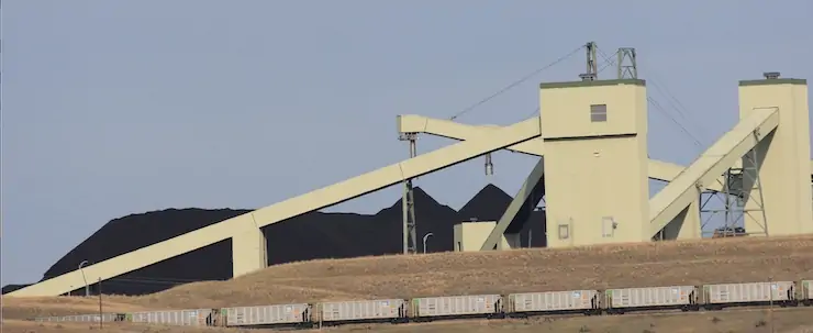
More than a year after an environmental group sued to stop a $2 billion northern Colorado water project, whispers of a settlement are being heard as the case winds its way through U.S. District Court in Denver.
Last January, Save The Poudre sued to block the Northern Integrated Supply Project, a two-reservoir development designed to serve tens of thousands of people in northern Colorado. The suit alleged that the Army Corps of Engineers had not adequately weighed the environmental impacts and less harmful ecological alternatives to the project…
Colorado-Big Thompson Project map. Courtesy of Northern Water.
Northern Water, which operates the federally owned Colorado-Big Thompson Project for the U.S. Bureau of Reclamation, is overseeing the permitting and construction of NISP. The agency also declined to comment on any potential settlement. Northern Water serves more than 1 million Front Range residents and hundreds of growers in the South Platte River Basin.
“We’re still moving forward with what we need to do on the litigation,” Northern spokesman Jeff Stahla said.
Northern Water’s board discussed the litigation in a confidential executive session last week at a study retreat and it is scheduled to discuss it in another private executive session Feb. 13 at its formal board meeting, according to the agenda.
Sources told Fresh Water News and The Colorado Sun that those discussions are related to the potential multimillion-dollar settlement.
Key developments this past year
In October, a federal judge delivered a favorable ruling to Wockner’s Save the Colorado on a case involving Denver Water’s Gross Reservoir expansion project. Now [envisonmental groups] are seeking an injunction to force Denver Water to stop construction of the dam, which began in 2022.
Workers from Denver Water and contractor Kiewit Barnard stand in front of Gross Dam in May to mark the start of the dam raise process. Photo credit: Denver Water.
Raising the Boulder County dam by 131 feet will allow Denver Water to capture more water from the headwaters of the Upper Colorado River on the Western Slope. In its ruling, the federal court said the U.S. Army Corps of Engineers had failed to consider the impact of climate change on the flows in the Colorado River.
What impact that ruling may have on the NISP case isn’t clear, but [the environmental group that sued Denver Water] said they believe it will give his organization more leverage to push for changes in NISP.
In addition, the City of Fort Collins has dropped its formal opposition to NISP. And Stahla said Northern has continued to push forward with key parts of the development, including the design work needed to relocate a 7-mile stretch of U.S. 287 northwest of Fort Collins.
Fort Collins Mayor Jeni Arndt said the city changed its stance because most of its environmental concerns had been met through the 21-year federal permitting process.
“The EPA had signed off, and the Corps of Engineers had signed off,” she said. “It was obvious that this was not going to be another Two Forks,” referring to a massive dam proposed in the 1970s by Denver Water on the South Platte River near Deckers. It was rejected by the EPA due to environmental concerns.
Arndt said the city also planned to use a later review process, known as a 1041 review, to address other environmental concerns that might arise.
If NISP is ultimately built, and most believe it will be, it will provide water for 15 fast-growing communities and water districts along the Interstate 25 corridor, including the Fort Collins-Loveland Water District, Fort Morgan, Lafayette and Windsor.
The largest participant in the giant project is the Fort Collins-Loveland District. Board member Stephen Smith said he believes NISP will move forward one way or another and that it is critical to serving the water-short region.
“NISP is going to get built and it will provide water to Fort Collins by 2033,” he said.
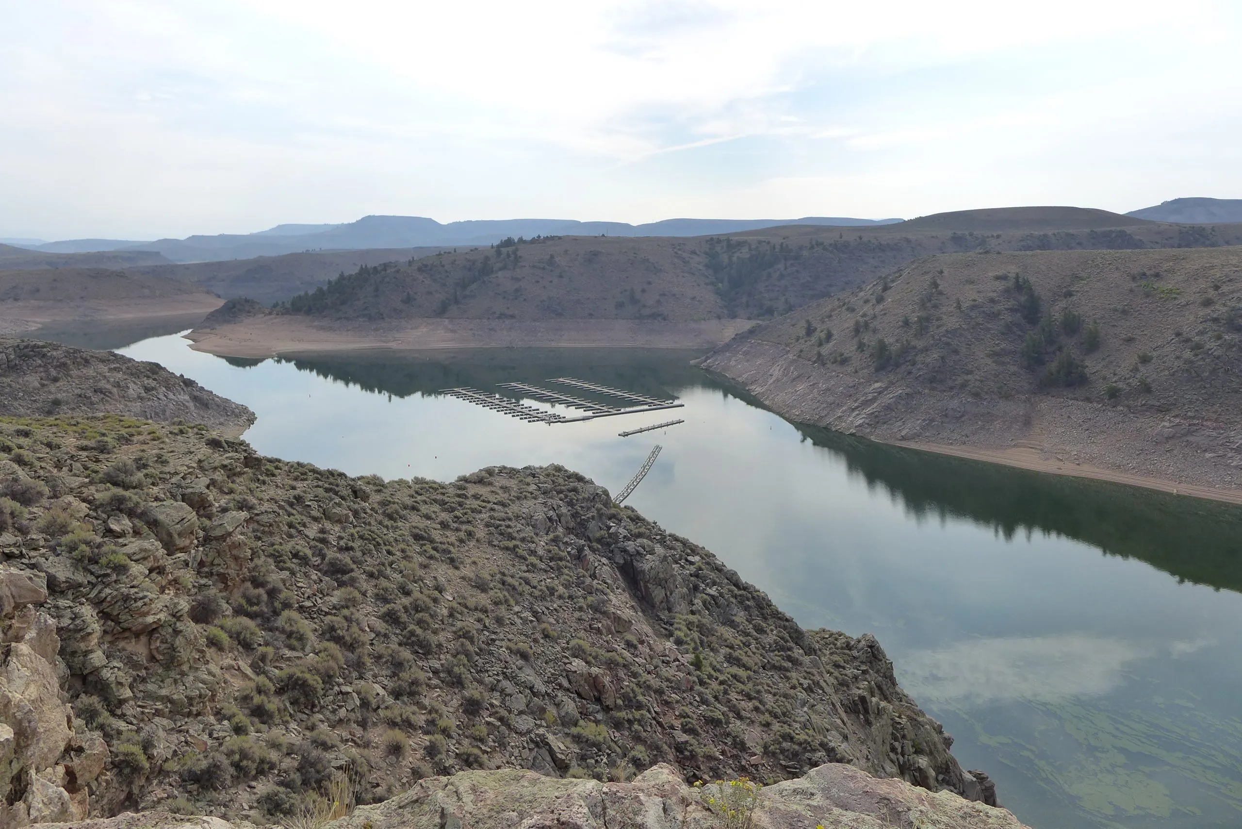
The Northern Integrated Supply Project, currently estimated at $2 billion, would create two new reservoirs and a system of pipelines to capture more drinking water for 15 community water suppliers. An environmental group is now suing the Army Corps of Engineers over a key permit for Northern Water’s proposal. (Save the Poudre lawsuit, from Northern Water project pages)
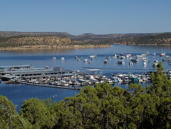
Elk Creek Marina at Blue Mesa Reservoir on the Gunnison River was temporarily closed so the docks could be moved out into deeper water in 2021 after federal officials made emergency releases from the reservoir to prop up a declining Lake Powell. Upper Colorado River Basin officials are requesting monthly drought-monitoring meetings with the U.S. Bureau of Reclamation in hopes of avoiding future last-minute emergency releases. Credit: Heather Sackett/Aspen Journalism
Water managers are preparing for another potentially lackluster runoff this year in the Colorado River Basin.
At a meeting Tuesday, water managers from the Upper Colorado River Commission agreed to write a letter to the U.S. Bureau of Reclamation asking for a monthly meeting to monitor drought conditions. Officials from the four Upper Basin states (Colorado, New Mexico, Utah and Wyoming) are hoping to avoid a repeat of 2021 when emergency reservoir releases caught them off guard.
“We want to be as prepared as possible since hydrology has flipped pretty quickly in previous years,” said UCRC Executive Director Chuck Cullom. “We think it’s prudent to collectively review the forecast and the water supply so that we aren’t caught in the situation we were in in 2021.”
Pine River Marina at Navajo Reservoir. Photo credit: Reclamation
From July through October of that year, Reclamation made emergency releases from three Upper Basin reservoirs: 20,000 acre-feet from Navajo, on the San Juan River; 125,000 acre-feet from Flaming Gorge, on the Green River; and 36,000 acre-feet from Blue Mesa, on the Gunnison River. The goal was to boost water levels at Lake Powell, which had fallen to a critical elevation, and ensure that Glen Canyon Dam could still produce hydroelectric power.
View below Flaming Gorge Dam from the Green River, eastern Utah. Photo credit: USGS
Guidelines for Upper Basin reservoir releases are laid out in the Drought Response Operations Agreement, which was signed in 2019 by the Upper Basin states and the federal government. The three reservoirs are part of the Colorado River Storage Project, and the federal government can authorize emergency releases from them without permission from the states or local entities.
But Colorado water managers were not happy about the timing or lack of notice from the bureau when the emergency releases happened in 2021. Drawing down Blue Mesa, Colorado’s largest reservoir, during the height of the summer boating season forced marinas to close early for the year and was a blow to the state’s outdoor recreation economy.
“It’s February, and we are seeing hydrology that could potentially impact reservoir operations,” Cullom said. “Let’s plan for it rather than reacting over a weeklong period. We’re trying to preempt some of the concerns and criticisms of reservoir operations in 2021.”
Water year 2021 was historically bad, with an Upper Basin snowpack that was near normal at 93% of average but translated to only 36% of average runoff into Lake Powell, the second-worst runoff on record. One of the culprits was exceptionally thirsty soils, which soaked up snowmelt before runoff made it to streams, due to 2020’s hot and dry summer and fall.
Credit: Laurine Lassalle/Aspen Journalism
Officials said current conditions could be setting the basin up for another year like 2021. Alex Pivarnik, a supervisor with the bureau’s Upper Colorado Operations Office, presented the latest data to commissioners Tuesday.
“Coming into the winter, soil-moisture conditions were pretty much dry throughout most of the basin,” Pivarnik said. “And January was a really bad month for us in the basin. … Coming into February, it was kind of a make-or-break for us.”
February’s “most probable” modeling projection for spring runoff into Lake Powell is 67% of average. The February forecast for total Powell inflow for water year 2025 is 71% of average.
Those numbers, taking into account snowpack conditions up until Feb. 5, were down from January’s most probable runoff forecast, which put Lake Powell’s spring inflow at 81% of average and total Powell inflow for water year 2025 at 82% of average.
After a storm cycle that brought snow to mountain ranges throughout the Upper Basin over Presidents Day weekend, snowpack for the Upper Basin stood at 94% of median as of Wednesday. In 2021, Upper Basin-wide snowpack on Feb. 19 was 89%.
“While the snow brought us some positivity, I still like to remind folks when we see Lake Powell at 35% full, that means it’s 65% empty and that’s troubling,” said Becky Mitchell, Colorado’s representative to the UCRC. “I want to note that we’ve been slightly optimistic because of the snow, but it still does not look as good as we’d like.”
Mitchell acted as chair of Tuesday’s UCRC meeting after former chair and federal representative Anne Castle was asked to resign by Trump administration officials last month. A new federal representative to the UCRC has not yet been appointed.
Snowpack for the Upper Colorado River Basin, water years 2021 vs. 2025
This chart shows how much snowpack has been measured at various SNOTEL stations located in the Upper Colorado River Basin.
Snowpack for the Upper Colorado River Basin, water years 2021 vs. 2025 This chart shows how much snowpack has been measured at various SNOTEL stations located in the Upper Colorado River Basin. Chart: Laurine Lassalle – Aspen JournalismSource: SNOTEL Get the dataCreated with Datawrapper
This is a critical time for Colorado River management as the Upper Basin states are in talks with the Lower Basin states (California, Arizona, Nevada) about how the nation’s two largest reservoirs, Lake Powell and Lake Mead, will be operated and cuts will be shared after 2026 when the current guidelines expire. Overuse, drought and climate change have driven reservoir levels to their lowest points ever in recent years.
Cullom gave an overview of the timeline needed to implement a new plan for post-2026 operations. The seven basin states need to reach agreement on a plan by early summer; the bureau would issue a final environmental impact statement by the spring of 2026 and a record of decision by August 2026. New guidelines would take effect in water year 2027, which begins Oct. 1, 2026.
Negotiations with the Lower Basin states, which ground to a halt at the end of 2024, have resumed, and Upper Basin commissioners said they are hopeful that they will reach a consensus. Failure to do so would mean river management decisions would be imposed by the federal government, which is something that state representatives want to avoid.
“A consensus is the best option out there for everyone, and I’m hopeful that we’ll get there,” Mitchell said, adding that “the highest level of certainty that we will have as seven basin states is if we can determine our own future. … I want to reiterate that we are committed to work with the Lower Basin states toward that seven-state consensus.”
Udall/Overpeck 4-panel Figure Colorado River temperature/precipitation/natural flows with trend. Lake Mead and Lake Powell storage. Updated through Water Year 2024. Credit: Brad Udall
Click the link to read the release on the Nature Conservancy website (Shaina Clifford, Linda Crider, and Chris Anderson):
January 27. 2025
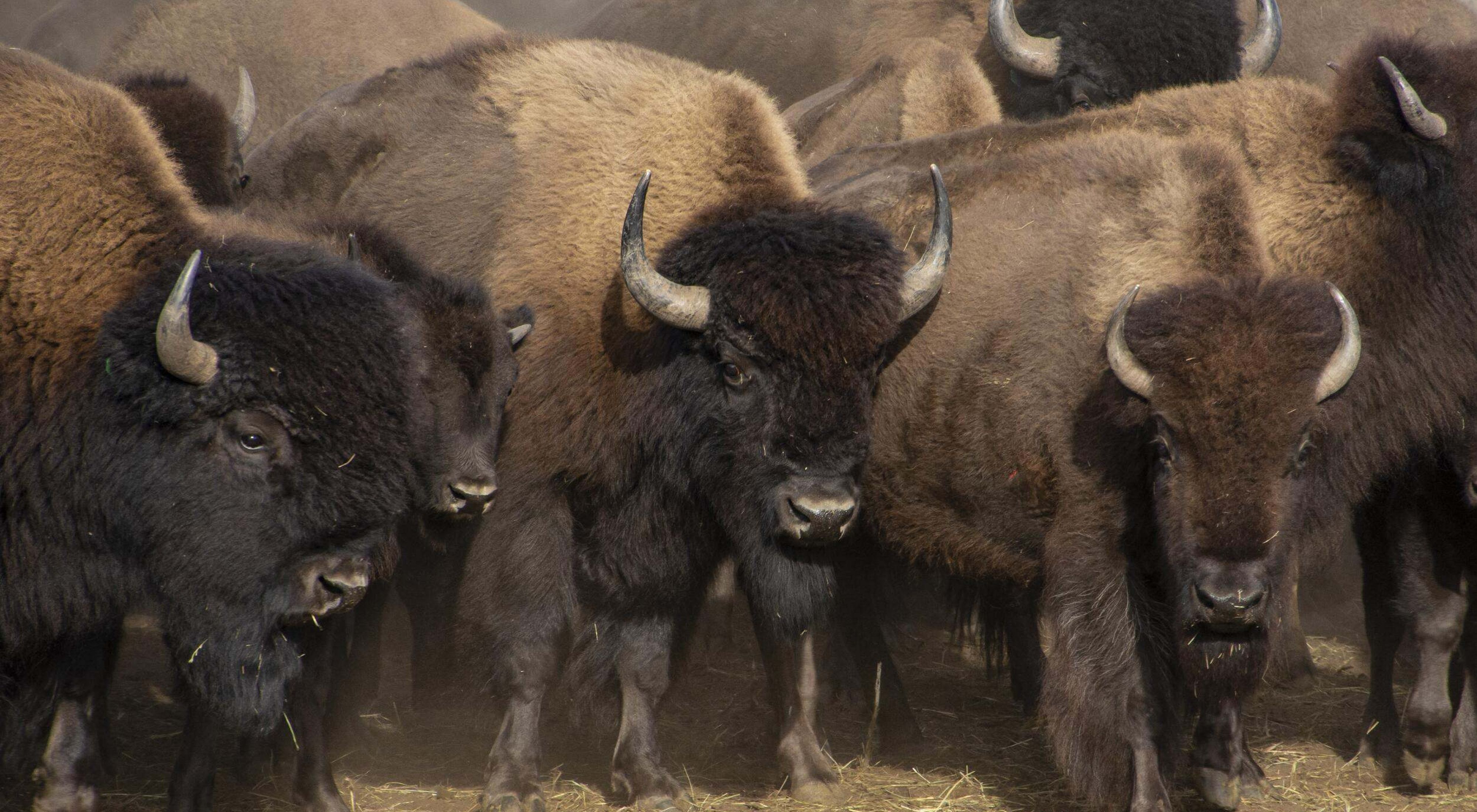
More than a dozen Indigenous communities welcomed over 540 buffalo, also known as American bison, back to ancestral grazing lands across the nation late last year as part of a multi-state, Indigenous-led initiative by the InterTribal Buffalo Council (ITBC), Tanka Fund and partner The Nature Conservancy (TNC). The initiative’s goal is to restore this keystone species, which plays a crucial role in spiritual and cultural revitalization, ecological restoration and conservation, food sovereignty, health and economic development for Indigenous Peoples.
Since 2020, partnerships with organizations such as ITBC and Tanka Fund have facilitated the return of over 2,300 buffalo from TNC preserves in Colorado, Illinois, Indiana, Iowa, Kansas, Missouri, Nebraska, North Dakota, South Dakota and Oklahoma to Indigenous communities.
In late 2024, 543 buffalo from TNC preserves were transferred to ITBC Member Nations and Tanka Fund caretakers in Iowa, Kansas, Minnesota, Montana, Nebraska, Oklahoma, South Dakota, Texas, Washington and Wisconsin.
“The buffalo’s journey back to Tribal lands is a journey of healing for the land, our people and future generations,” said Ervin Carlson, ITBC’s Board President. “This past year has marked another step forward, and the future holds even greater possibilities for restoration and growth.”
Buffalo rematriation within Native lands is an essential step in repairing the relationships severed by U.S. government policy and the ensuing violence against Native people, as well as the extensive conversion of natural areas. Each buffalo brought home represents a positive force of partnership and perseverance, supporting sustainable economies, workforce development, youth empowerment, food sovereignty and the preservation of Indigenous knowledge for future generations.
“Our collaboration with The Nature Conservancy to restore buffalo to their native lands and caretakers not only honors the rich cultural heritage of Indigenous communities, but it also reinforces our shared commitment to ecological restoration and sustainable practices,” said Dawn Sherman, Executive Director of Tanka Fund. “Together, we are revitalizing families and communities, healing the land and nurturing a thriving future.”
The presence of buffalo, which can weigh upwards of 2,000 lbs., helps build resilience against a changing climate. Bison hooves work the ground to create space for new plants to grow, their droppings provide nutrients for soil microorganisms, and native grass seeds can stick to their fur and disperse as the animals move across the land. Their grazing behavior and the effects they have on the prairie help a wide range of wildflowers, plants, insects and amphibians to flourish.
“The Nature Conservancy is a proud partner of this Indigenous-led movement, and we are thrilled that more than 2,300 buffalo have returned home to their ancestral lands,” said Corissa Busse, Buffalo Restoration Program director for The Nature Conservancy. “The restoration of buffalo has been a profound journey of healing for Indigenous communities and for our prairies and grasslands. Together, we are building a future where culture and ecology thrive.”
About The InterTribal Buffalo Council (ITBC) ITBC is a federally chartered Tribal organization, formed in 1992 as a gathering of 17 Tribes. Today, it has a membership of 86 Tribal Nations and growing every year, sharing a mission to restore buffalo to Indian Country to preserve our historical, cultural, traditional, and spiritual relationship for future generations. To reestablish healthy buffalo populations on Tribal lands is to reestablish hope for Indian people. Returning buffalo to Tribal lands will help to heal the land, the animal, and the spirit of Indian people.
About Tanka Fund The Tanka Fund is a Native American-led 501(c)(3) nonprofit organization located on the Pine Ridge Reservation that aims to revitalize Native American buffalo populations, ecosystems and economies. The organization provides grants, technical assistance and other resources to Native American tribal producers that are working to restore buffalo populations and promote sustainable buffalo-based businesses.
About The Nature Conservancy (TNC) The Nature Conservancy is a global conservation organization dedicated to conserving the lands and waters on which all life depends. Guided by science, we create innovative, on-the-ground solutions to our world’s toughest challenges so that nature and people can thrive together. We are tackling climate change, conserving lands, waters and oceans at an unprecedented scale, providing food and water sustainably and helping make cities more sustainable. Working in 76 countries and territories—37 by direct conservation impact and 39 through partners—we use a collaborative approach that engages local communities, governments, the private sector and other partners. To learn more, visit www.nature.org or follow @nature_press on X.
There are increasing calls to incorporate indigenous knowledge (IK) into climate adaptation planning (CAP) and related projects. However, given unique attributes of IK and the positionality of tribal communities to scientific research, several considerations are important to ensure CAP efforts with IK are ethical and effective. While such topics have been thoroughly explored conceptually, incorporation of IK into CAP is a nascent field only beginning to report findings and improve science production and delivery. Based on recent work with Ute Mountain Ute (UMU) resource managers and knowledge holders, we reflect on key considerations for incorporating IK into CAP: the importance of sustained and multi-level tribal engagement, operational approaches to IK incorporation, cross-cultural challenges with risk-based approaches, and how CAP can support existing tribal priorities. We hope exploring these considerations can help set appropriate expectations, promote ethical interactions, and increase the effectiveness of tribal CAP and related efforts.
1 Introduction
Climate change adaptation planning (CAP) increasingly seeks to incorporate the valuable knowledge held by indigenous communities (Makondo and Thomas, 2018; Mbah et al., 2021; Petzold et al., 2020). Indigenous knowledge (IK; a body of observations, oral and written knowledge, innovations, technologies, practices, and beliefs developed by Indigenous Peoples through interaction and experience with the environment; U.S. Department of the Interior, 2023) offers unique insights into past and present climatic conditions and can inform adaptation strategies (Nyong et al., 2007). However, incorporating IK into CAP raises critical considerations of ethics, effectiveness, and the unique positionality of IK vis-à-vis western science (WS; Latulippe and Klenk, 2020; Makondo and Thomas, 2018; Mathiesen et al., 2022).
Related topics such as IK research ethics, IK integration, and tribal sovereignty, have been explored theoretically for a variety of applications, but lessons learned from on-the-ground CAP with IK are still needed (Petzold et al., 2020). In this manuscript, we reflect on an on-going CAP effort that incorporates IK with the Ute Mountain Ute (UMU) Tribe and share considerations for others seeking to incorporate IK in CAP. While these considerations are not exhaustive—indeed, we encourage others to build upon this initial set—sharing this initial set is motivated by the growing number of calls to incorporate IK and WS (Gadgil et al., 1993; Hoagland, 2017; Jessen et al., 2022; Nyong et al., 2007; Sidik, 2022; Williams et al., 2020) and the attendant risks to tribal communities (Carroll et al., 2020; Keane et al., 2017). We share practice-based lessons with the aims of supporting CAP practitioners and researchers navigating the complex terrain of IK incorporation and fostering ethical collaboration for the benefit of tribes, federal agencies, and environmental managers.
The UMU climate project (hereafter UMU-CP) first began during a conversation between staff at the North Central Climate Adaptation Science Center (NC CASC) and the UMU Environmental Department during a site visit to Towaoc, CO, in December of 2019. The UMU-CP was designed to support implementation of the recently completed UMU climate adaptation plan (UTE Mountain UTE Tribe, 2020) by using both IK and WS to mainstream climate information into UMU manager decision making processes. The project team includes the UMU Climate Change Coordinator, NC CASC researchers, a USDA Forest Service adaptation specialist, a non-profit scientist, and UMU natural resources personnel. To date, the UMU-CP has entailed site visits, regular virtual meetings, and a scenario planning workshop. Through these engagements, the project has brought remote sensing analysis, IK, climate data, and subject-matter expertise to bear on a climate-informed assessment of ongoing and future UMU resource stewardship projects and planning.
Engagement of tribal governments including tribal natural resource management programs does not, however, de-facto constitute incorporating IK expertise as such institutions may or may not reflect and/or represent traditional tribal cultural systems (Ciocco et al., 2023; Cohen, 1942; O’brien, 1993). Although the terms traditional ecological knowledge (TEK) and indigenous knowledge have been used in various contexts (see Green, 2008; Onyancha, 2024 for details), their recognition as valid evidence for inclusion in federal policy, research, and decision-making requires adherence to specific standards regarding the quality and transparency of data sources, as well as the preservation of tribal intellectual property (Brush, 1993; Lefthand-Begay et al., 2024; Ornstein, 2023). For this reason, incorporation1 of IK can be approached as a sub-component of broader engagement with a tribal government (Figure 1). While tribal engagement alone in a project does not constitute IK incorporation, intentionally designed and comprehensive engagement can pave the way for IK incorporation (Steen-Adams et al., 2023).
Graphic credit: Frontiers in Climate
This engagement can take multiple forms, including inform (notifying collaborators of research results), consult (indirect engagement of collaborators through interviews, expert elicitation and related methods), participate (direct and sustained engagement in the knowledge production process), and empower (sustained and direct engagement with methods designed to address power imbalances; Bamzai-Dodson et al., 2021). Here, consult engagement should not be confused with tribal consultation—the formal government to government process (Blumm and Pennock, 2022; Executive Office of the President, 2022; Washburn, 2023). Projects with the goal of IK incorporation may need to engage with multiple entities or organizations within a tribe, rather than solely engaging with an individual entity within a tribe (for example, just the tribal department of natural resources or the tribal historic preservation officer).
Importantly, multiple modes of engagement can be applied within a single project to engage with the multiple entities within a tribe, as was done for the UMU-CP (Figure 1). The overall process was led by biophysical and adaptation scientists and the UMU climate change coordinator (lead engagement). Engagement between these team members began a year before the formal start of the project and included a site visit and many conversations about how to support UMU climate adaptation efforts. Once the formal project began, this project team obtained consent to implement the project from the UMU Tribal Council and coordinated with the UMU THPO in the collection and preservation of IK (inform engagement). IK was elicited from UMU IK-holders via interviews and was then incorporated into the CAP process by managers and researchers (consult engagement; see section 2 for details). UMU resource managers were involved in various stages of the project, but their participation in the scenario planning process, which entailed the translation of climate information into insights for adaptation (empower engagement), was especially important. Deliberately identifying a project’s modes of engagement with various partners is important for scientific transparency and setting expectations. Flexibility in project aims and timeline were also critical to responding to evolving constraints (e.g., COVID-19 pandemic) and partner needs and capacity.
3 Operational approaches to incorporating indigenous knowledge into climate adaptation planning
IK may be incorporated throughout each of the stages of CAP (e.g., consider etic-emic dialectic methods; Chen, 2010; Dalton et al., 2018; Darling, 2017; Eckensberger, 2015; Miller et al., 2017); however, a common approach is to rely on WS throughout CAP and incorporate IK in a limited fashion for select stages. As a generic example, limited incorporation may entail a western scientist saying to IK-holders:
This can be contrasted with a more comprehensive incorporation, or even integration, of IK:
While broadening the scope of IK incorporation may be laudable, limited IK incorporation may be necessary or preferred by IK-holders, tribal institutions, or scientists (Dalton et al., 2018).
As mentioned in Section 1, our approach to operationalizing these theoretical concepts may be described as a form of consult engagement with IK holders to inform the assessment of climate change impacts (Figure 1). At the project outset, the depth of IK incorporation was left open ended, as it was difficult to determine a priori the most appropriate roles IK would play in the UMU-CP. The UMU Climate Change Coordinator and a local Ute elder conducted interviews with individual Ute elders, selected by recommendation of the Ute elder collaborator. Semi-structured interviews were generally conducted in the respondents’ home setting with a few in an office setting. All interviews were conducted in English with the audio recorded. To maintain data sovereignty, IK interviews were kept as an internal-tribal data source, housed in coordination with the THPO for tribal member access. Excerpts selected by the UMU Climate Coordinator were made available for review by workshop participants.
By employing interviews with IK holders in this engagement, we expand the set of consult engagement tools from commonly applied expert elicitation methods such as Delphi (Mukherjee et al., 2015; Tseng et al., 2022) to include other social science methods of knowledge elicitation that may not typically be considered tools for “consultation” per se. However, IK incorporation into environmental management decision making without involvement of dedicated anthropologist or ethnographic expertise can mean that important methodological considerations may be inadequately addressed (Davis and Wagner, 2003).
We offer a non-comprehensive conceptual roadmap of important methodological considerations for IK incorporation (Figure 2). These include the type of source IK is derived from (e.g., group interviews/focus groups/councils/panels; Frey and Fontana, 1991; McLafferty, 2004; textual analysis; Marcus and Cushman, 1982); and how that source was sampled to represent the larger body of IK (Bernard, 2017; Davis and Wagner, 2003; Lichtman, 2017). The location, setting, and language within which the IK was elicited, which can influence cultural-linguistic code-switching (Molinsky, 2007; Wehi et al., 2009). For example, interviewing an IK-holder at a sacred site in their native language may produce very different responses than an interview conducted in an office setting in English (Wehi et al., 2009). Rapport is heavily emphasized in indigenous research methods and may include interviews conducted by fellow tribal members and close family members, and long-term relationship building between researchers and IK-holders (Albuquerque et al., 2019) and ideally within broader co-management arrangements (Chapman and Schott, 2020; Schott et al., 2020; Washburn, 2022). We also include coarse typologies of methods for design, elicitation, interpretation, and aggregation as used throughout social science research (Bennett et al., 2017; Bernard, 2017; Charnley et al., 2017; Skinner, 2013; Cox, 2015). This roadmap is not a substitute for involving social scientists; rather, we hope that wider use of such a roadmap might raise awareness of the methodological decisions entailed in IK elicitation and promote collaboration with social scientists that are attuned to the nuances of these and other methodological choices.
Graphic credit: Frontiers in Climate
4 Risk-based framing of climate adaptation planning presents inter-cultural challenges
Risk-based approaches to climate adaptation require assessment of climate-related threats and vulnerabilities for specific environmental resources (Kettle et al., 2014; Kuklicke and Demeritt, 2016). Climate change scenario planning (Miller et al., 2022) and related CAP methods thus involve envisioning future climate conditions and events—including severe droughts, floods, and fires—and their implications. Implications include climate change “winners” or management opportunities, and even the undesirable implications can be effective at increasing awareness and motivating action (Burt and Nair, 2020; Davidson and Kemp, 2023). Recognizing that CAP often deploys such methods with the aim to empower managers to meet their management goals, nuanced attention to the cross-cultural impact of risk-based approaches is nonetheless critical to ethical IK engagement.
For example, consider the relative moral obligation and self-efficacy experienced by a hypothetical manager and an elderly IK-holder in addressing a drying fresh-water spring. The manager may see the spring as a livestock drinking station, an economically valuable but replaceable commodity, and may be equipped with funding, equipment, operational guidelines, and staff to address it. The IK-holder may view the same spring as an irreplaceable home to deities known in visceral relational terms and may have relatively limited capacity to implement restoration.
For the UMU-CP scenario planning workshop, the primary audience was UMU environmental managers, and the scenario planning exercise seemed to promote productive recognition of the climatic changes confronting the Tribe. Two IK-holders also had the opportunity to participate directly in the workshop. Envisioning implications of different future climate conditions for resources yielded scenarios involving extreme drought, loss of traditional foods, and desertification of rangelands. These implications evoked sincere discussions by IK-holders regarding the ability of young generations to/not to continue cultural traditions, community health and survival, and historical and future resolve to stay in their homelands.
Deepening the sense of moral obligation, some IK systems may entail a feeling of responsibility for climatic changes, perceiving climate change as occurring in part due to lack of community adherence to ceremonial protocols (Boillat and Berkes, 2013). Envisioning environmental catastrophes may also invoke apocalyptic prophecies found throughout many Native American religions (Irwin, 1997; Irwin, 2014).
In so much as IK-holders may muster proactive responses to envisioned climate change scenarios, such responses may take unique forms (Ford et al., 2016) such as ceremonial activities, youth engagement, or restoring traditional cultural practices (Boillat and Berkes, 2013; Schramm et al., 2020). For example, the Tribal Climate Adaptation Menu lists ‘Consider cultural practices and seek spiritual guidance’ as the first adaptation strategy for addressing climate change impacts (TAM (Tribal Adaptation Menu) Team, 2019). Given that ceremonial practices are not widely supported climate adaptation strategies in formal management settings, such thinking may inadvertently be stifled in lieu of more normative management interventions.
5 Climate adaptation planning can support and align with tribal priorities
Federally recognized tribes retain political and legal sovereignty, including the right to self-determination (Cornell and Kalt, 2010; Tsosie, 2011), yet often face an onslaught of proposals and requests from extractive industries, religious institutions, renewable energy, gaming and other economic enterprises, environmental organizations, and other sectors (Blumm and Pennock, 2022). In this context, it is all the more important that researchers and federal agencies respect the authority of tribal leaders and communities to determine what is in their own best interest and support such efforts by providing impartial information to empower tribal-led solutions.
Tribes often must weigh climate adaptation measures at serious opportunity costs. Many tribes face complex social challenges including but not limited to addiction crises, unemployment, lack of housing and basic utilities of running water and electricity, heightened rates of violence and suicide, chronic disease, pollution, culture and language loss (Akee et al., 2024; Ehrenpreis and Ehrenpreis, 2022; Hardy and Brown-Rice, 2016; Hilton et al., 2018). Tribal citizens ultimately pay the price (often a visceral and existential price to themselves and family members) of diverting resources from these immediate challenges toward climate adaptation or other concerns. Yet our experience illustrated the rapidly closing window for IK incorporation into environmental management (Aswani et al., 2018; Tang and Gavin, 2016; Okui et al., 2021), as multiple elders set to be interviewed during the project passed away before interviews were conducted.
In tribal natural resource management, a salient and under-recognized concern is that tribes may lack comprehensive natural resource management plans (Ciocco, 2022; Jampolsky, 2015). The American Indian Agricultural Resource Management Act (AIARMA; 25 USC Ch 37), tribal forest management policy (25 USC Ch 33), and a host of related federal policies call for the development of tribal agriculture, water, forest, wildlife, and other management plans, ostensibly coalesced into an Integrated Resources Management Plan (Hall, 2001). When tribes lack such planning documents to organize management under current climatic conditions, planning for potential future conditions may be seen as putting the cart before the horse. With foresight, however, CAP may be strategically used to both plan for climate change while back-filling more immediate or fundamental natural resource planning needs. In a similar vein, CAP may present opportunities to intersect with many of the broader aforementioned social challenges faced by tribes (Castells-Quintana et al., 2018; Poiani et al., 2011; Tucker et al., 2015).
The UMU-CP effort sought to build on the Tribe’s recently developed climate action plan. While the UMU-CP project team explored the possibility of tying research projects to high-level tribal management planning documents, managers ultimately preferred to connect the UMU-CP to a number of active management projects, reassessing those projects’ objectives and strategies. The ongoing collaboration with UMU may further lead to new projects and other future directions, but this is contingent on the Environmental Department’s priorities and capacity.
6 Conclusion
Integrating indigenous knowledge (IK) into climate adaptation planning (CAP) requires thoughtful attention to tribal engagement, operational approaches to IK incorporation, the cultural implications of risk-based approaches, and support for tribal priorities. Addressing these factors is crucial for more comprehensive incorporation of IK at the programmatic level (Ciocco et al., 2023), ensuring culturally relevant climate adaptation for tribes (Reid et al., 2014), and realizing the potential of IK to inform broader climate adaptation efforts (Pisor et al., 2023). However, effective CAP efforts involving IK often encounter challenges due to incentives that encourage researchers and agencies to reduce costs and time commitments. While dedicated expertise and long-term relationship-building may mitigate some of these challenges, genuine personal and institutional investments are irreplaceable.
Data availability statement
The original contributions presented in the study are included in the article/supplementary material, further inquiries can be directed to the corresponding author.
Happy Valentine’s Day! Every mid-February we take a day to let our romantic partners know how much they mean to us, or perhaps more cynically, to give money to Hallmark. Growing up, this was never one of my favorite holidays. For one, I was a nerd, and usually single. For two, I suffer from a tinge of seasonal affective disorder. Once the glow of Christmas, New Year’s, and a holiday break wears off, we are left to suffer through the remainder of the cold season with relatively few festivities. Growing up in northern Colorado my rule of thumb was always “things get better after Valentine’s Day.”
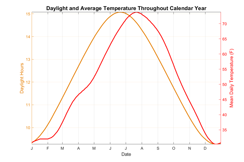
If you are somebody who is impacted by the short daylight hours and low sun angles, chances are you have already noticed things getting better. Here in Fort Collins, the sun rose at 7:21 AM and set at 4:37 PM on the winter solstice in late December. Today the sun rose at 6:54 AM and will set at 5:34 local time. That is over an hour and a half of improvement! Having said that, if you are somebody who is impacted more by cold temperatures than short days, yesterday morning’s low of -5 ˚F probably did you no favors. Of course, not every mid-February day is so cold, but even the average daily minimum temperature on Valentine’s Day is only 20 ˚F, just three degrees warmer than the average low in late December. Similarly, the mean daily temperature (daily max + daily min)/2 on Valentine’s Day is 33 ˚F, only 3 ˚F warmer than late December.
We know that the sun is our primary source of energy here on Earth, and we know that winter is cold because the northern hemisphere, in which we live, is tilted away from the sun. Conversely, summer is warmer because the northern hemisphere is tilted towards the sun, leading to longer days and more direct sunlight. The days are already getting much longer. Why are we not heating up more quickly?
As it turns out, at a large scale, the atmosphere takes about one month to adjust to an increase or decrease in solar forcing. This creates a cycle wherein changes in average temperatures lag changes in daylight by about a month. This plays out almost like a dance between light and heat where light leads and heat follows. To illustrate this point, I grabbed the Fort Collins 1991-2020 daily temperature normals data from SCACIS, and sunrise/sunset times for 2025 from timeanddate.com. A 15-day smoothing filter was applied to the temperature data for the sake of improved visualization (this means each day’s temperature normal is an average of the current day, and the seven calendar days before and after). The plot of our daylight hours throughout the year is nearly a perfect sine wave peaking at the summer solstice in June and hitting a minimum at the winter solstice in December (it is not a perfect sine wave because the earth’s orbit is not perfectly symmetrical). The plot of average temperatures similarly looks like a sine wave, but is phase shifted by about one month.
Light and heat’s annual dance is not perfectly choreographed here in Fort Collins, nor in most any other location. If you’re looking closely at these graphics you probably also noticed some asymmetries and additional wiggles in our average temperature curve. I want to talk about two of the main ones, which I will define with the following terms: the summer:winter asymmetry and the spring shimmy. The summer:winter asymmetry refers to the fact that average temperatures are at their lowest right around the winter solstice, but at their highest a full month after the summer solstice (July 20-24). Were this a dance, you could imagine light spinning heat out in the summer and corralling heat back in for the winter.
Our summertime average temperatures peaking in late July fits perfectly with the explanation above of temperatures trailing solar forcing. Temperatures reaching a minimum just about in lockstep the winter solstice does not fit with our above explanation. According to climatologist Brian Brettschneider, who wrote a tremendous blog post on seasons back in 2017, there is actually a dearth of scientific literature over why seasonal fluctuations vary from place-to-place the way they do. My hypothesis is that average precipitation is a bit higher on the northern Front Range in November and December than January and February, so there may be a slightly higher probability of cloudy conditions during this time, keeping averages lower in December than January.
The spring shimmy refers to the wiggle in average temperature’s increase in April. In our dance analogy, heat is accelerating pace to catch light, but does a toe drag. This behavior is much easier to explain. Fort Collins sees its highest average precipitation in late April through early June. We definitely see cloudier conditions around this time, and more of the sun’s energy goes into evaporation and transpiration during this time because of the wetter surface conditions. Both of these factors slow our warming pattern in spring.
The spring shimmy shows up even more prominently if we find a way to display both daylight and temperatures using one line on the same graph. In the image below I computed what we’ll call a “heat fraction” for each day of the year. This is computed as follows: [Current day average temperature – Lowest day average temperature]/[Highest day average temperature – lowest day average temperature]. The highest average daily temperature is 74F (in July) and the lowest is 30 F (in December). The formula above gives a unitless quantity with a max value of 1 (in July) and a minimum value of 0 (in December). As an example, the average temperature on October 1st is 56 F, so the heat fraction would be [56-30]/[74-30] = 26/44 = 0.59. I did the same for “light fraction” which uses the same formula above, but for daylight hours. Below I plotted the difference between the two: heat fraction – light fraction. It reaches a maximum value of +0.21 on September 8th and a minimum value of -0.3 on April 30th, right during our wettest time of year.
The temperature dataset actually includes some additional even smaller wiggles. My supposition is that these wiggles are mostly due to the fact that we are only using 30 years of data: 1991-2020. Our climate normals are just an average of wildly varying day-to-day weather conditions. Even though we used 30 years of data and applied a smoothing filter to the temperature dataset, there are still likely to be some small peaks and dips due to highly anomalous individual weather events. Take for instance December 2022 (see graph below): temperatures were mostly warmer than normal until right before Christmas when we quickly plummeted to a low of -17 ˚F. It takes a lot of years of data to fully smooth out events like this.
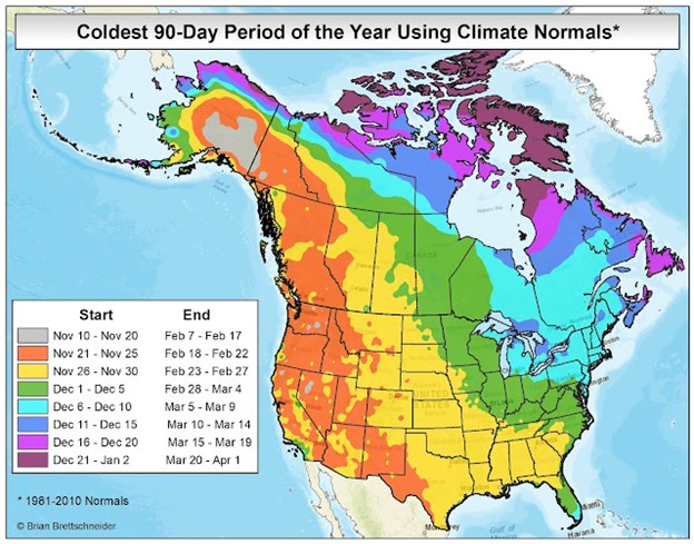
Other locations: Not all locations in the northern hemisphere experience their average peak summer heat or frigid winter weather at the same time. Using data from the National Centers for Environmental Information we can see that much of the country does experience the coldest weather in January rather than December. The image below from Brian Brettschneider’s blog shows that the start and end of the average coldest 90-day stretch of the year varies significantly across North America. The Arctic Circle does not see any sunlight all winter, so it is not surprising that the average coldest 90-day period is later: lasting from late December all the way until late March. Most of the country sees the coldest weather of the year between late November and late February, but the northeastern United States sees a bit longer lag with the coolest 90 days lasting from early December to early March. Conversely, most of North America experiences its warmest weather between early June and early September. Coastal areas tend to see their warmest weather a little later in the season because ocean waters heat up and cool down more slowly in response to solar forcing than land and air.
After all this information, I want to bring the focus back to my opening statement about seasonal affective disorder that “Things get better after Valentine’s Day.” We see in the data that our days are already getting longer, and at an accelerating pace. Furthermore, while average temperatures have not warmed much yet, they are certainly about to. The average temperature on Valentine’s Day is 33 ˚F, but one month later it’s 41 ˚F. Three months from now it’s 57 ˚F. Even so, winter is not over yet. This is neither medical nor even climatological advice, but my advice for staying happy during cold weather is to embrace it. February and early March is a perfect time of year for all sorts of winter fun like downhill and cross-country skiing, snowshoeing, and ice skating. You don’t even have to do anything fancy. When I go outside to walk in cold weather I rarely regret it unless conditions are also windy. In contrast, if I use cold weather as an excuse to hibernate, eat unhealthy food, and overconsume insipid short-form content on my phone, I regret that every time.
The storm is good news for the region’s water supply, which has languished in recent weeks. The SNOTEL site at Cascade Creek, just north of Purgatory Resort, reported 18 inches of snow accumulation since Thursday afternoon, which translated to 1.2 inches of snow-water equivalent. The side near the top of Coal Bank Pass reported 20 inches of snow accumulation and 1.8 inches snow-water equivalent. Lemon Reservoir had received 16 inches of snow with 1½ inches of snow-water equivalent as of 6 p.m. Friday….
Peter Goble, an assistant state climatologist at the Colorado Climate Center, said the snowpack is lower than it has been since 2018 – and one storm won’t turn that around.
“Every storm like this is a storm we’ll take, at this point,” he said, but he noted that the region needs several more storms to catch up to normal snowpack levels.
Soil moisture in the region is not as dry as recent years, he said. And that’s good news because arid soils suck up snowmelt, reducing runoff.
Colorado snowpack basin-filled map February 16, 2025 via the NRCS
Click the link to read the article on the Land Desk website (Jonathan P. Thompson):
February 11, 2025
🗺️ Messing with Maps 🧭
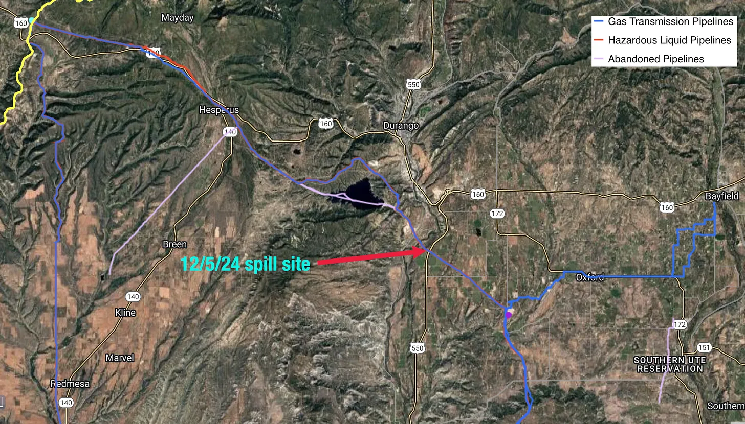
Detail of a 1931 New Mexico oil and gas map showing part of the San Juan Basin, where commercial drilling began in earnest in the early 1920s. Note that there were already pipelines running from Bloomfield to Albuquerque, from the Ute Dome to Durango and from the Rattlesnake Dome to Gallup.
On the afternoon of December 5, 2024 at least seven homes were evacuated in rural La Plata County, Colorado, after a major pipeline ruptured and spilled some 23,000 gallons of gasoline 1. Two months later, lingering fumes and contamination kept at least one of the evacuated households from returning home, according to the Durango Herald.
The spill tainted nine domestic wells with benzene concentrations of up to 300 parts per billion; the carcinogen’s maximum allowable level is 5 parts per billion. And the nearby Rainbow Springs trout farm suffered an 80,000 fingerling die-off in the days following the spill, according to the Herald, though a conclusive link between the two has yet to be made.
Graphic credit: The Land Desk
That a bunch of hydrocarbons broke free from their confines in that part of the country didn’t shock me: La Plata County is in the San Juan Basin, where oodles of natural gas has been pumped from the ground over the last century or so, and leaks, breaches, and spills have been frequent — sometimes with deleterious results. But I was a bit taken aback to read that the material that spilled was gasoline that came from a major, interstate pipeline.
In fact, several Facebook commenters expressed their doubts, saying it must have been drip condensates or liquid natural gas, instead, coming from one of the lines associated with the gas fields or the processing plant nearby. But the Herald reporter got his info directly from the pipeline operator (and they should know). And I double-checked the Pipeline and Hazardous Materials Safety Administration incident report, which said Enerprise Products’ Four Corners Lateral Loop pipeline, which was installed in 1980, had spilled 544 barrels (or 22,848 gallons) of non-ethanol gasoline.
Curiously, both Energy Information Administration and PHMSA records show that only natural gas-carrying lines pass through the county. But apparently the line now carries auto fuel from Texas to New Mexico, Colorado, and Wyoming, where it helps keep pump prices affordable, or so the pipeline operator told the Herald.
It’s one of seven natural gas, carbon dioxide, or hazardous liquids pipelines — totaling 225 miles — that cross La Plata County. The Western states contain about 93,024 miles of these long-distance methane and petroleum carrying lines (this does not include local gathering systems that web their way through the oil and gas fields or natural gas distribution lines that run through towns and cities).
The top 15 counties in the Western U.S. in terms of gas transmission and hazardous liquid pipeline mileage. Source: PHMSA.
That’s one of those things about pipelines. You might be subtly aware they exist, thanks to the strips of land that have been cleared of vegetation and the signs warning you not to dig there. But the fact that there are large quantities of flammable, sometimes explosive, climate-altering substances rushing beneath your feet on their way to distant destinations is not something that is often at the top of one’s mind. At least not until they leak, rupture, or explode.
Graphic credit: The Land Desk
And they do, more often than most of us would hope. Usually the cause is corrosion, a failed weld, or some other type of equipment or material failure, though excavation-caused ruptures are also up there. Cars and trucks run into pipelines and break them, floods or seismic activity can tear them apart, and sometimes lightning strikes them.
Natural gas is composed mostly of methane, a potent greenhouse gas with about 86 times the atmospheric warming potential than carbon dioxide. So every release is contributing to climate change. A major breach or a slow leak that goes undetected can emit massive amounts of methane; in April, a construction worker breached a pipeline that released 118,000 MCF (thousand cubic feet) of natural gas before it was shut off 2. Plus, when the stuff builds up it can explode, which makes gas line leaks especially dangerous. Crude oil and gasoline spills, meanwhile, can harm wildlife, waterways, and people, and even carbon dioxide pipeline ruptures can be fatal.
So it’s good to have strong regulations around pipelines, as well as a well-staffed agency to enforce those regulations. It’s also nice to know where the major pipelines are around you. And for now, at least, you can find out by consulting the PHMSA’s National Pipeline Mapping System. Just enter your state and county and you get a map of the big hazardous liquid and natural gas transmission lines. You can also do an accident query and see where there have been accidents near you. One drawback is that the system limits how far you can zoom in on the map, apparently because they’re worried about saboteurs using it to locate targets. Here’s what the zoomed in map looks like. This is about the same view as the opening image from 1931.
Graphic credit: The Land Desk
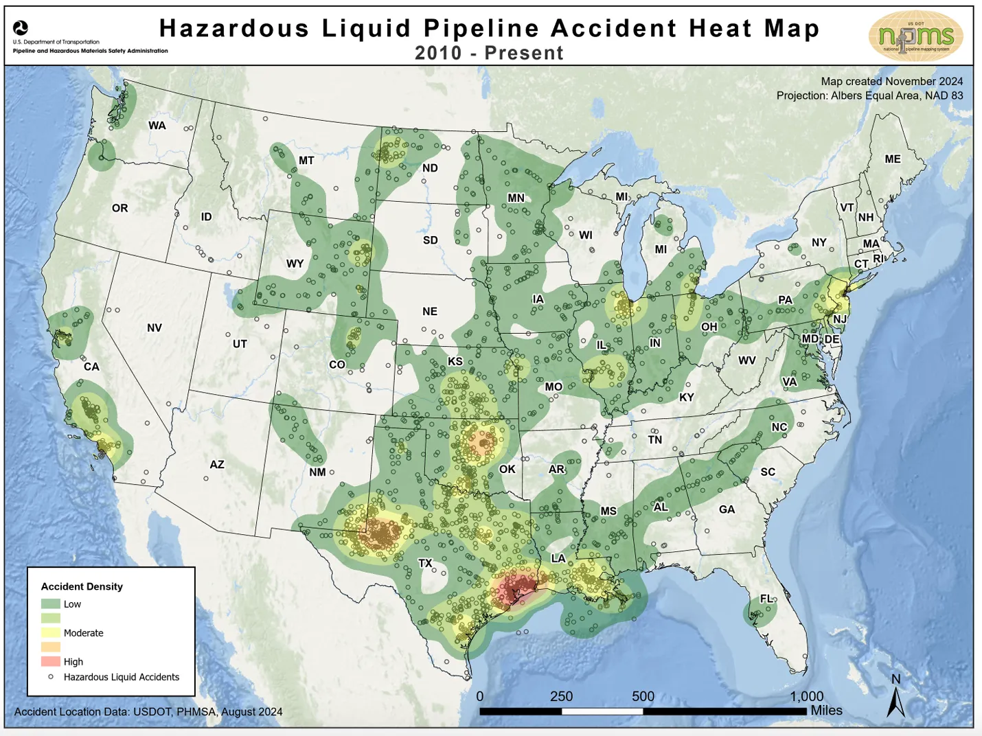
Here are some zoomed out maps to give you a sense of where the pipelines are concentrated, with the highest densities in the Permian Basin and Louisiana.
Graphic credit: The Land Desk
Graphic credit: The Land Desk
Graphic credit: The Land Desk
Graphic credit: The Land Desk
DATA DUMP:
122 Number of U.S. interstate natural gas transmission system incidents, accidents, and spills in 2024, resulting in 7 injuries.
1.82 million MCF Volume of natural gas released during those incidents.
Corrosion The leading cause of natural gas transmission pipeline incidents.
13, 28 Number of fatalities and injuries, respectively, resulting from natural gas distribution system incidents nationwide in 2024.
309,560 MCF Volume of natural gas released during distribution system incidents.
$549,000 Total damages, as of early February, resulting from the Enterprise pipeline spill in La Plata County in December.
192 Number of incidents reported on Enterprise Products Operating pipelines between 2017 and 2025.
294 Number of incidents in interstate hazardous liquid pipelines nationwide in 2024.
80 Number of hazardous liquids incidents in 2024 that occurred in pipelines that were installed prior to 1985. Ten of the damaged lines were installed prior to 1940.
16,708 Barrels of crude oil spilled in 2024 pipeline incidents.
3,333 Barrels of refined petroleum products spilled or lost in 2024 pipeline incidents.
$70 million Total damages resulting from hazardous liquid (crude oil, gasoline, and other products) pipeline incidents in 2024.
Parting Poem
Now for something completely different, I’d like to leave you with this lovely poem by Richard Shelton. It’s from his Selected Poems, 1969-1981, which is easily my most read book, as I come back to it time after time. No one captures the essence of the desert like Shelton.
1 Which is about enough gasoline to fuel the ol’ Silver Bullet (the Land Desk’s official mascot) for another 800,000 miles or so.
2 The average U.S. residence uses about 65 MCF of natural gas per year.
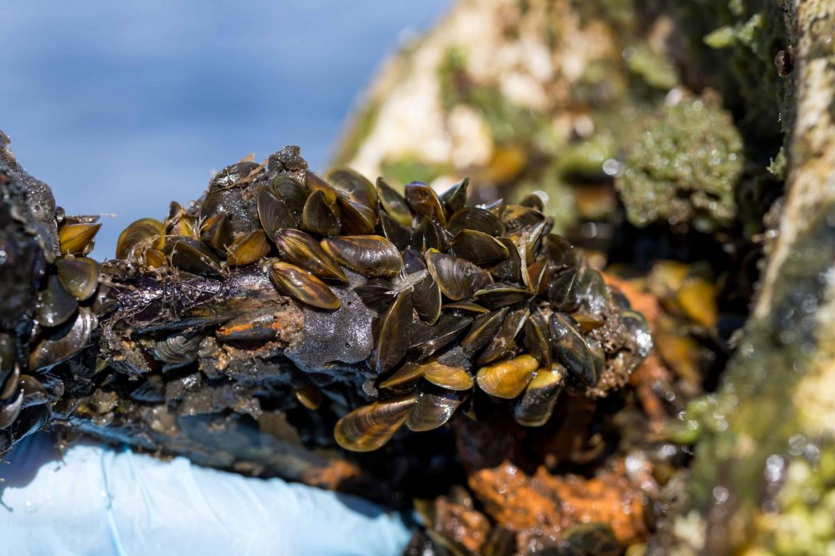
Golden mussels are clustered on a buoy during a survey in November 2024 at O’Neill Forebay at the foot of San Luis Reservoir in Merced County. (Source: California Department of Water Resources)ion Foundation
A new aquatic invader, the golden mussel, has penetrated California’s ecologically fragile Sacramento-San Joaquin Delta, the West Coast’s largest tidal estuary and the hub of the state’s vast water export system. While state officials say they’re working to keep this latest invasive species in check, they concede it may be a nearly impossible task: The golden mussel is in the Golden State to stay – and it is likely to spread.
The fingertip-size mussel is believed to have hitchhiked into the Delta in the ballast water of a freighter from Asia that docked at the Port of Stockton. The mussel was first detected there in October 2024, and its discovery set off alarm bells among water managers and environmental scientists. The reason: Unlike their cousins the quagga mussels, which have infested major Colorado River facilities in Southern California, golden mussels can tolerate a wider range of aquatic environments and may have more opportunities to do so.
The golden mussel is just the newest invasive headache for water agencies across the West. Quagga mussels turned up in the lower Colorado River in 2007, and agencies in California, Arizona and Nevada that draw water from the river have had to intensify monitoring and costly maintenance to try to limit their impact. Another cousin, the zebra mussel, was discovered last summer in the upper Colorado River in Colorado. The zebra mussel also has turned up in a small reservoir in San Benito County south of San Francisco that, as a result, has been closed to the public since 2008.
In Northern California, federal, state and local water managers are already trying to limit the golden mussels’ spread. They’re inspecting boats entering and leaving many lakes and reservoirs or have even shut down boat ramps entirely until more is known about the threat. And operators of state and Northern California water agencies have stepped up monitoring, inspections and cleaning of equipment where they’ve found mussels.
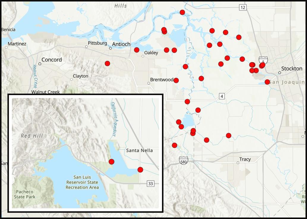
Golden mussels have been found at various locations in the Sacramento-San Joaquin Delta and at O’Neill Forebay, at the foot of San Luis Reservoir in Merced County. (Source: California Department of Fish and Wildlife)
State officials believe the golden mussels may have arrived a couple of years ago given their size and spread. The mussels have been found as larvae and adults in about 30 areas around the central and southern Delta. More concerning because it suggests a wider infestation, golden mussels have been detected in O’Neill Forebay at the foot of San Luis Reservoir in Merced County. The reservoir impounds water exported from the Delta by both the State Water Project and the federal Central Valley Project, two of California’s largest water projects. From O’Neill, golden mussels could potentially spread deep into the San Joaquin Valley via the Central Valley Project, and all the way to San Diego through the State Water Project.
Andrew Cohen, director of the Center for Research on Aquatic Bioinvasions based in Richmond, believes that their presence in O’Neill Forebay is just an indicator of things to come.
Given how far they’ve spread from the Delta and how interconnected the state and federal water projects are, Cohen said, “there’s no precedent for thinking we’re going to be able to eradicate them.”
A different kind of mussel
Golden mussels are native to the rivers and creeks of Southeast Asia and can be distinguished by the yellow-brown hue of their shell. While they were known to have spread to South America, they had not been detected in North America until their discovery in the Delta last fall.
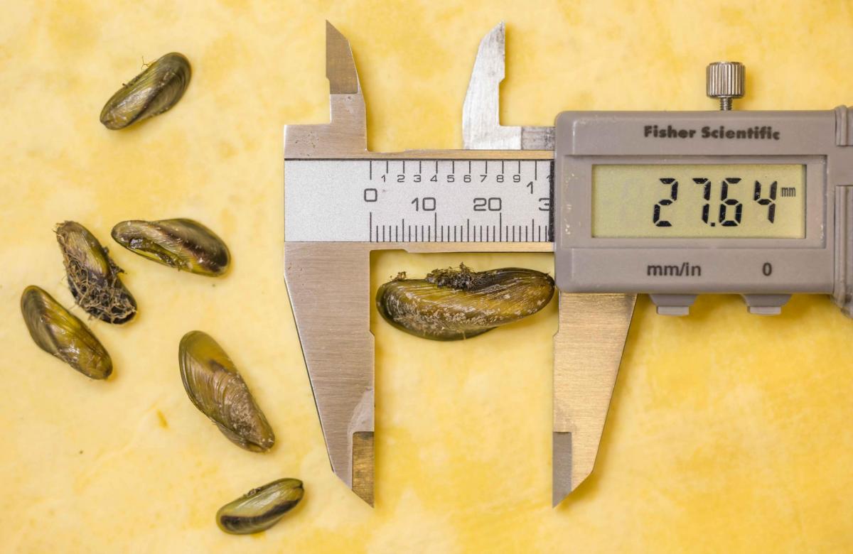
Adult golden mussels, like those shown here, are about the size of a fingertip. (Source: California Department of Water Resources)
They are prolific reproducers and prodigious filter feeders that can alter the food web, rob native species of food sources and, by clarifying source water, contribute to algal blooms. Golden mussels are an added burden in the Sacramento-San Joaquin Delta, which already must contend with more than 185 other non-native plants, fish and animals.
Golden mussels are similar in size and shape to quagga and zebra mussels, which have invaded other waters of the state but not the heart of the Delta.
Like their more established cousins, golden mussels are known to attach in clusters to hard surfaces like pipelines and other water system infrastructure, clogging pipes and screens. Clearing them from water facilities could add millions to maintenance costs.
An important factor that differentiates golden mussels is biology. They are able to complete their lifecycle in water bodies with lower calcium levels than what is needed to sustain shell growth for quagga or zebra mussels. That means more areas of the California watershed are vulnerable to infestation.
Eradicating mussels from larger bodies of water is nearly impossible, experts say. Nascent efforts in South America employ genetic splicing to produce sterile golden mussels in the hopes that in the wild they will neutralize proliferation. Whether it will work remains to be seen.
Quagga and zebra mussels have been eradicated only from closed systems where water has been drawn down to expose the mussels to air or by flooding the water body with a chemical biocide. Neither of those methods is possible in the Delta. Chemical treatment could affect a host of other life forms.
“We can’t draw the Delta down. We can’t flood it with any kind of biocide,” said Cohen, with the Center for Research on Aquatic Bioinvasions. “It’s just not possible to do those things, aside from the fact that the environmental impacts will be such that we would never do them.”
With eradication unlikely, Thomas Jabusch, a senior environmental scientist with California’s Department of Fish and Wildlife, said more resources are going to be needed to contain golden mussels and limit their spread. “We have to up the ante now,” he said, “because more water bodies are open to an infestation by invasive mussels and all the consequences that brings.”
Slowing the inevitable
If golden mussels do spread throughout California, experience with mussel infestations elsewhere suggest it may take years or decades to occur. Cohen noted that in the East, zebra and quagga mussels have spread slowly, riding the flow of water or hitchhiking on boats.
Their impact on the Great Lakes, however, has been costly. A 2021 report titled Economics of Invasive Species estimated that zebra mussels cause $300 million to $500 million annually in damages to power plants, water systems and industrial water intakes in the Great Lakes.
Their impact in California, so far, has been more limited. The state Department of Water Resources spends around $3.3 million annually on early mussel detection and prevention at its various State Water Project facilities.
Additional prevention costs are shouldered by California State Parks and Los Angeles County. The focus right now is on preventing golden mussels from proliferating.
Tanya Veldhuizen, Special Projects Section Manager for DWR’s Environmental Assessment Branch, said that efforts are being made to increase the cleaning of infrastructure, application of anti-fouling coatings, and manual cleaning and flushing of small diameter piping. Boats are required to pass inspection before entering a State Water Project reservoir. If they fail inspection, boats must dry out for seven days.
State Fish and Wildlife Warden Timothy Bolla and K-9 Warden “Luna”, a German shepherd, perform a routine random quagga mussel inspection of a boat before it is put in on this ramp to the Sacramento River in August 2020. (Source: California Department of Water Resources)
All watercraft leaving State Water Project reservoirs with established golden or quagga mussel populations are required to undergo an exit inspection in which boat drain plugs are pulled so that all residual water in bilges, livewells and ballasts drains out.
Some facilities – like the East Bay Municipal Utility District’s Pardee and Camanche reservoirs and the Bureau of Reclamation’s New Melones Lake, all in the Sierra foothills – have elected to suspend boat launches until the threat from golden mussels can be better evaluated.
California’s Department of Fish and Wildlife uses three methods to search for mussels. They check their infrastructure by looking and feeling for mussels. They also place sediment samplers in strategic locations to see if mussels are growing on them. Finally, they filter plankton out of the water and then look at those samples under microscopes.
“Once mussels are in a water body, it’s more about control and containment than specifically about eradication,” Jabusch said. “The main focus should really be on prevention; containment in the places where they currently are and preventing water bodies that don’t have mussels from getting mussels.”
Containing the Spread of Mussels
Metropolitan Water District, which serves 19 million Southern Californians as the largest supplier of treated water in the United States, has been on the front lines of the battle against quagga mussels and expects a lengthy fight to keep its infrastructure clear of golden mussels. Although a costly nuisance, the mussels don’t directly affect the quality of treated drinking water, Metropolitan says.
Paul Rochelle, Metropolitan’s water quality manager, said that chemical controls have played a large role in controlling the spread of quagga mussels.
Metropolitan Water District continually injects a low dose of chlorine into three locations of the Colorado River Aqueduct to target quagga mussel larvae and keep them from settling and becoming adults. The annual cost just for chlorine is between $3 million and $5 million, Rochelle said.
“The challenge with chlorinating large volumes of water or large distances of water is that chlorine eventually either dissipates or it gets bound up by organic material in the water,” Rochelle said. “So we apply chlorine at the start of the Colorado River Aqueduct. And by 12 to 15 or so miles in, much of the chlorine has dissipated.”
Metropolitan crews also put muscle into mussel control. Every year, the entire aqueduct is shut down for three weeks for routine maintenance, allowing it to dry out and for mussels to be scraped off the concrete and equipment. Those costs for quagga control are part of the agency’s larger operation and maintenance budget, he said, and aren’t broken out.
Rochelle said it would be harder to chlorinate State Water Project pipelines because the water has different characteristics than Colorado River water. Chlorine could react with organic matter in the State Water Project and produce potentially harmful disinfection byproducts. Still, he said, water agencies are evaluating the feasibility of chemical controls due to the lingering presence of quagga mussels in Pyramid and Castaic lakes in Northern Los Angeles County, which receive State Water Project water.
Quagga mussels were first found in both Pyramid and Castaic lakes in 2016. Years later, the frequency of the mussels significantly increased. Metropolitan believes the calcium concentration in Lake Castaic increased enough so that quagga mussels could thrive. What accounts for the rise in calcium is hard to pin down, but Rochelle said wildfires may release calcium in the soil and rain may wash that into the water.
Quagga mussels like the ones seen here were first detected in the lower Colorado River in 2007 and have since spread to a number of Metropolitan Water District facilities in Southern California. (Source: California Department of Water Resources)
Two of Metropolitan’s reservoirs in Riverside County, which receive Colorado River water, have also been infested with quagga mussels. But a third reservoir, the massive Diamond Valley Lake, Southern California’s largest at 810,000 acre-feet, quit receiving Colorado River water about a year before quaggas were discovered. The lake now receives only State Water Project water and has been protected from quagga infestation by rigorous boat inspections.
“If boat inspections hadn’t been effective, then it’s possible Diamond Valley Lake would’ve been infested by now,” Rochelle said.
For now, Rochelle believes the best prevention against the spread of golden mussels lies in monitoring. Metropolitan conducts eDNA testing on plankton samples that can identify golden and quagga genetic material. It is consulting with other agencies on the best way to protect bodies of water connected to the State Water Project.
“Because if you can prevent the infestation, job done,” Rochelle said. “It’s a lot harder to eradicate them once they’re established.”
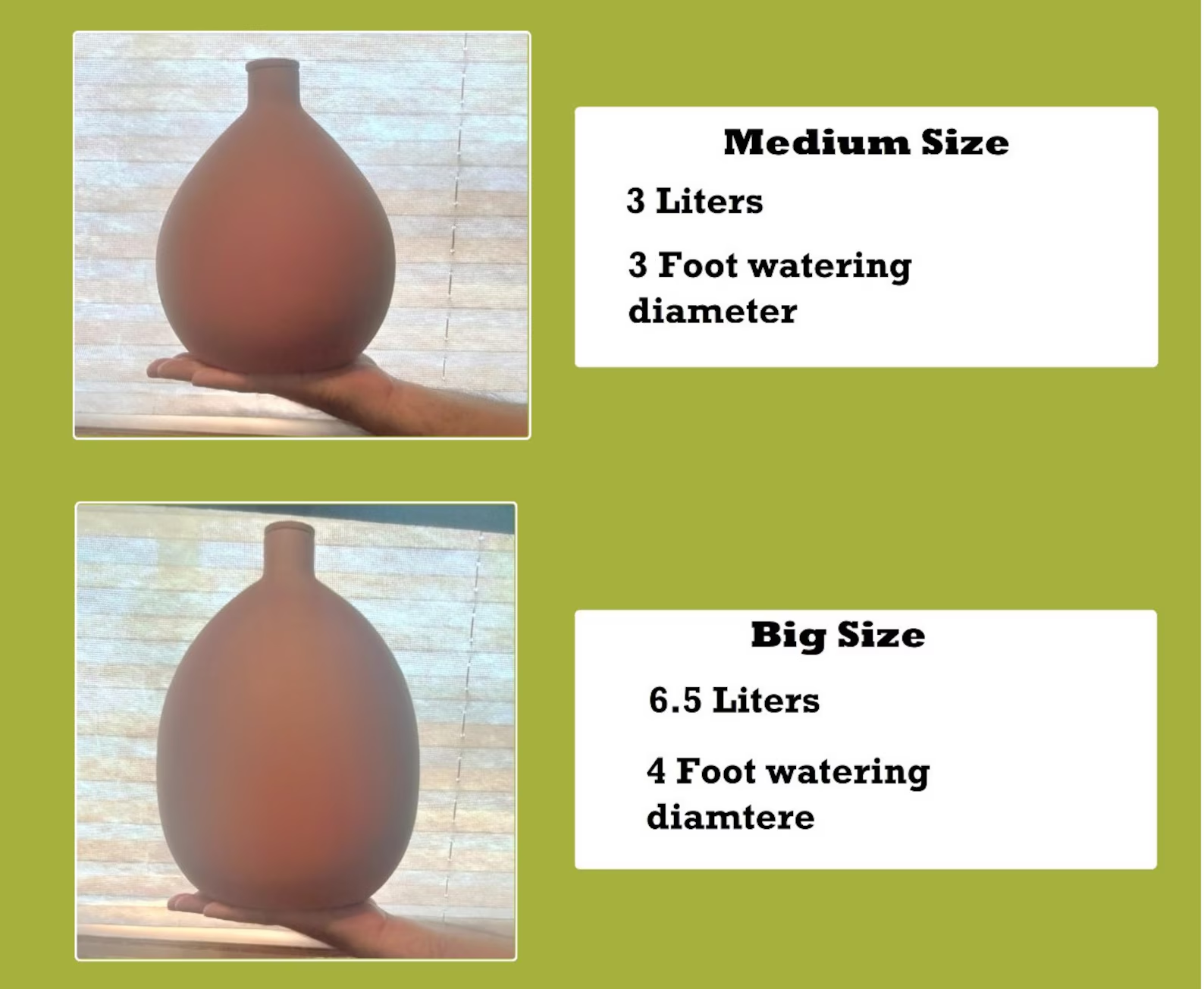
The old is new again and this time, it’s saving water. Residents in the desert southwest are rediscovering the use of clay pots for watering plants and there’s a company in Tucson that’s trying to mass produce the “olla balls” for wider use. Experts say they use much less water than typical present-day irrigation methods. Producer: Tony Paniagua
Produced water. Graphic credit: U.S. Department of Energy
Feb 13, 2025
This webinar, aired on February 11, 2025, focuses on produced water. We cover some basics about water in the oil and gas industry, learn about proposed new rules focused on reusing that water (which are expected to be adopted in early 2025) — and the negotiations that have surrounded them, hear about the Colorado Produced Water Consortium, and explore opportunities and challenges as the industry and environmentalists look at what it means to stretch freshwater use and to reuse more water. With speakers: Harmony Cummings, the Green House Connection Center Hope Dalton, Colorado Produced Water Consortium Josh Kuhn, Conservation Colorado John Messner, Colorado Energy and Carbon Management Commission Grant Tupper, Select Water Solutions
Click the link to read the article on The Denver Post website (Elise Schmelzer). Here’s an excerpt:
February 11, 2025
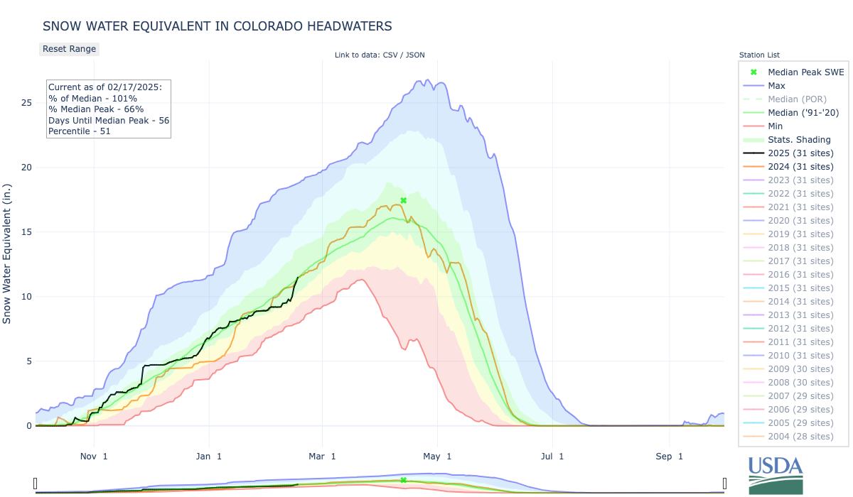
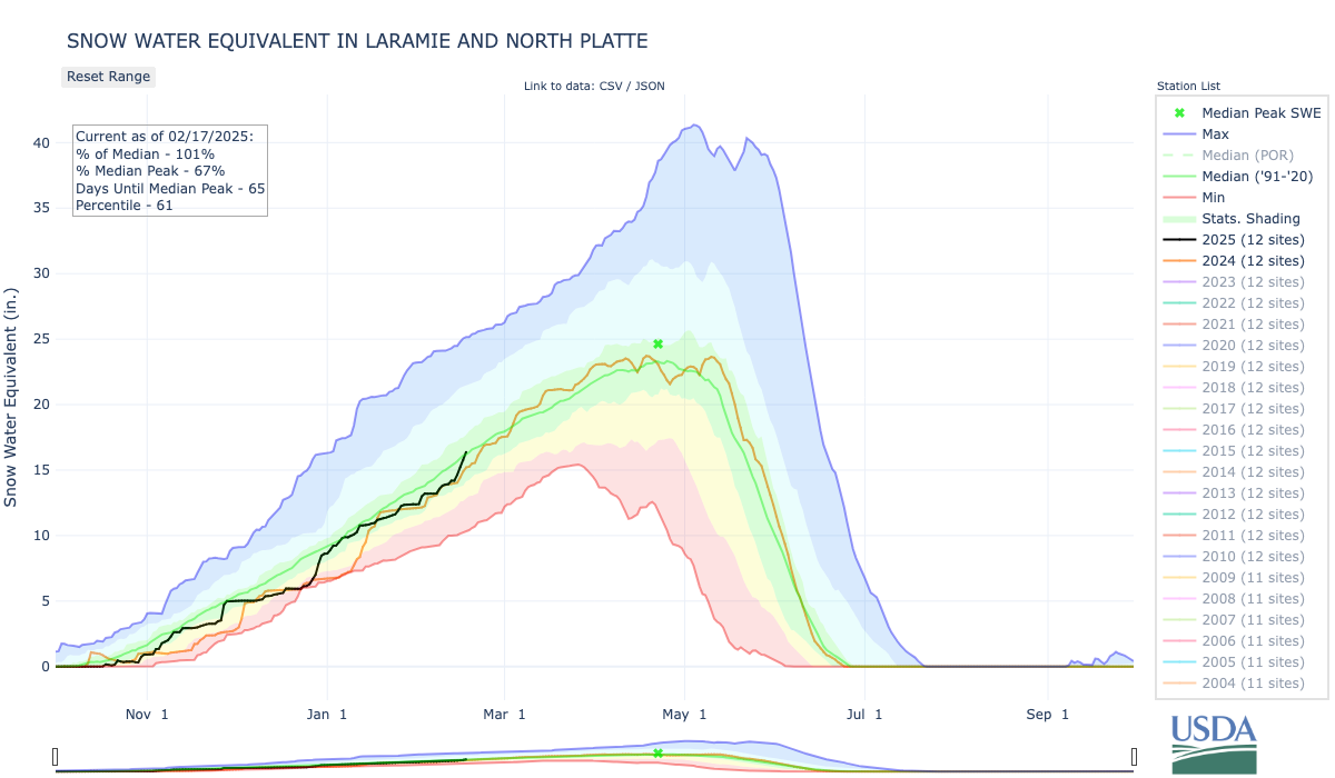
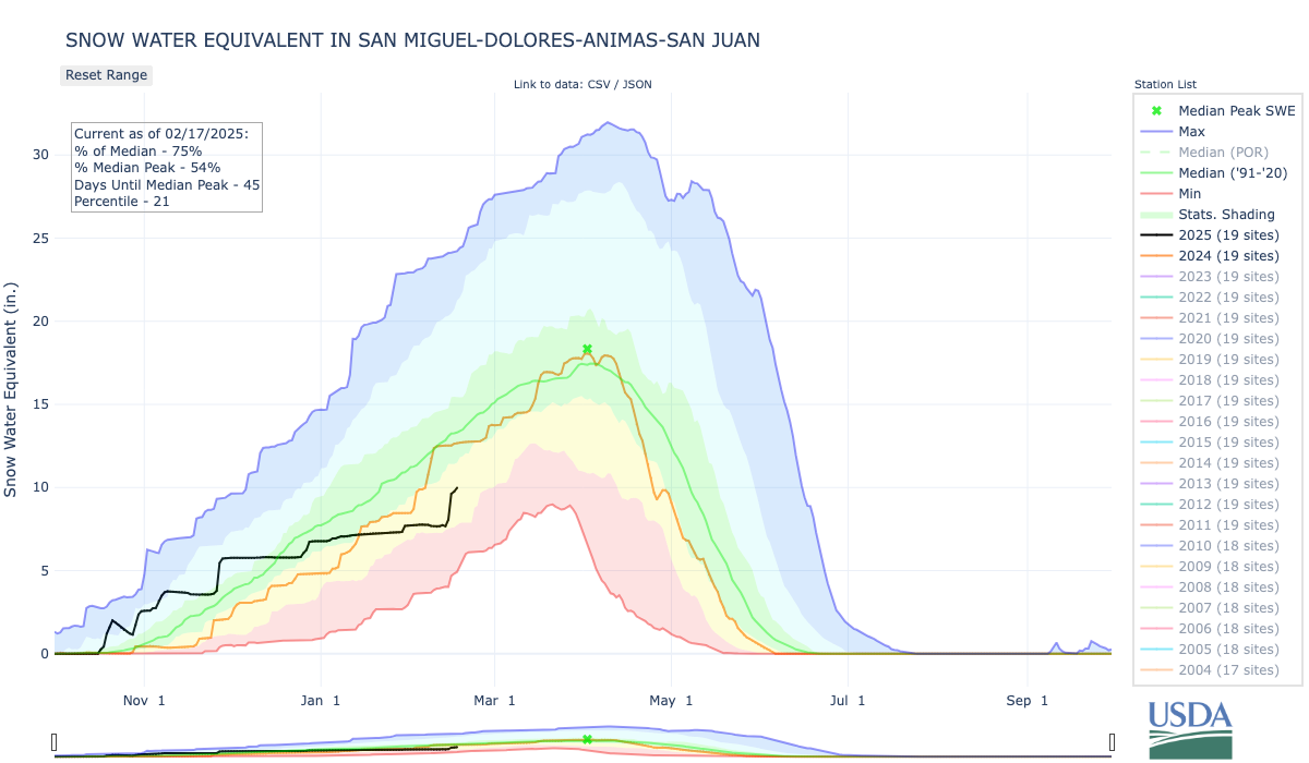
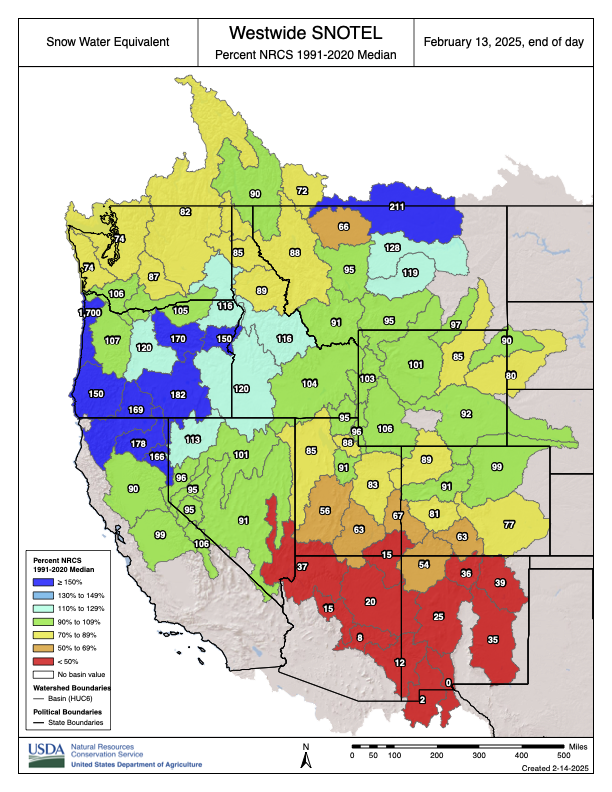
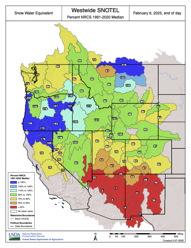
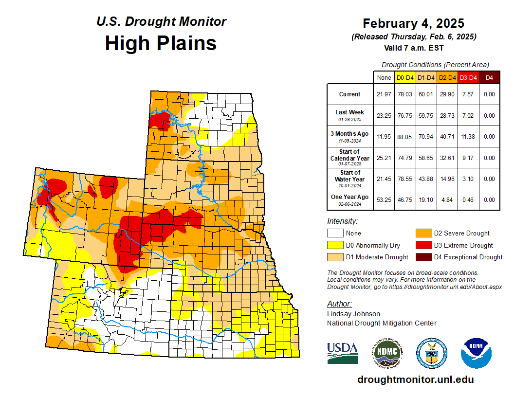
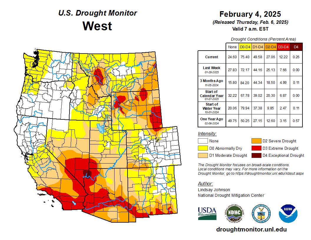
Snowpack across Colorado ranges from close to normal levels near the Colorado River headwaters, outside Grand Lake, to troublingly low along the state’s southern border. The pattern of snow conditions worsening from north to south is also visible across the broader mountain west — where snowpack is near normal in the most fortunate places and drastically below normal in the southern tail of the Rocky Mountains…
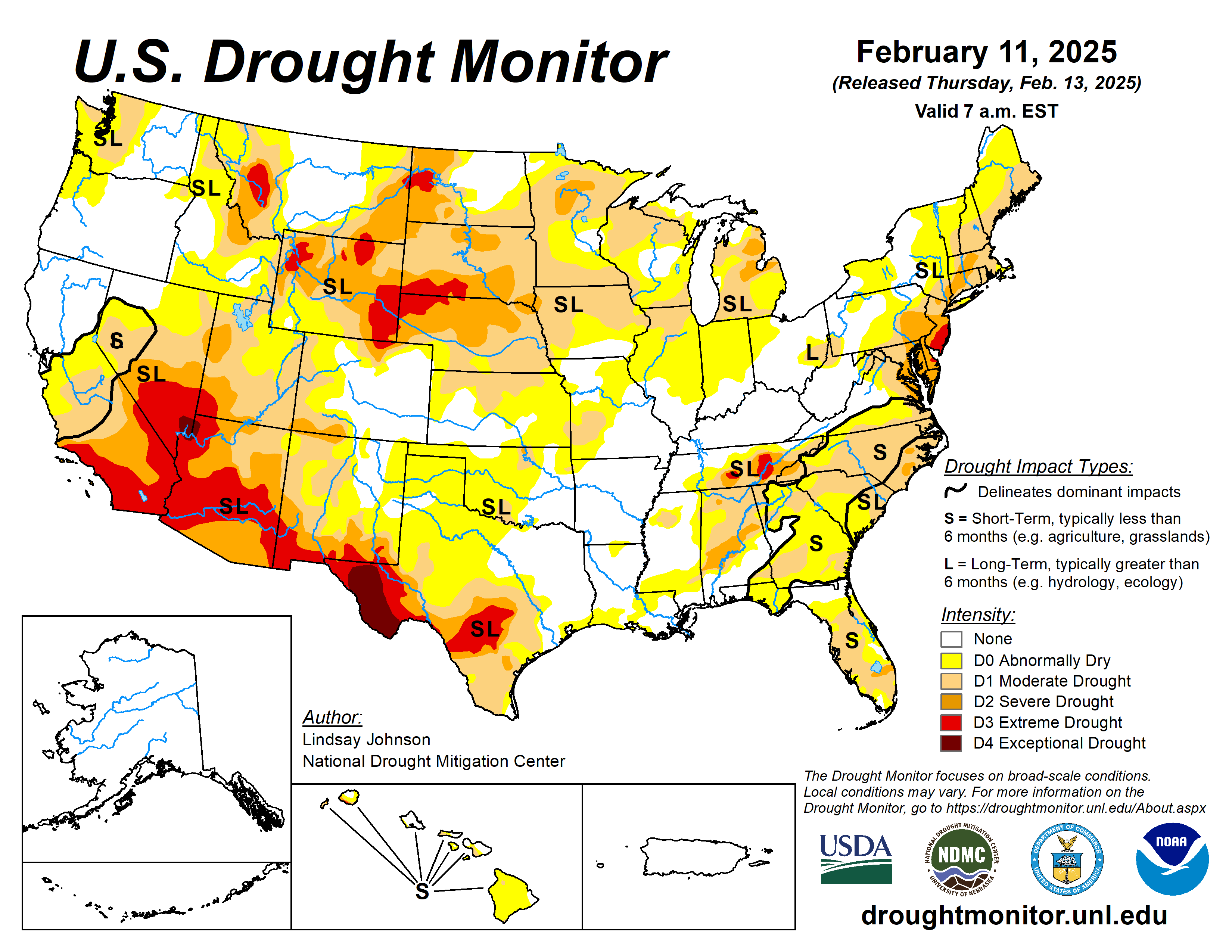
West Drought Monitor map February 11, 2025.
The drought across much of the mountain west follows a year when many states recorded some of their warmest average temperatures in the last 130 years. 2024 was Colorado’s fourth-warmest year in that time period, and it was the second-warmest year for New Mexico and Utah and the third-warmest year for Arizona and Wyoming…
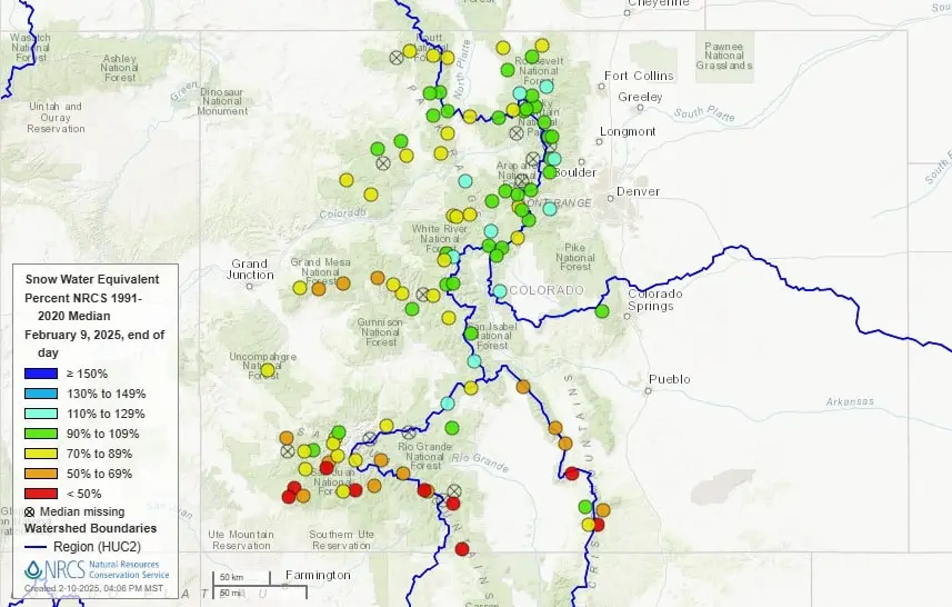
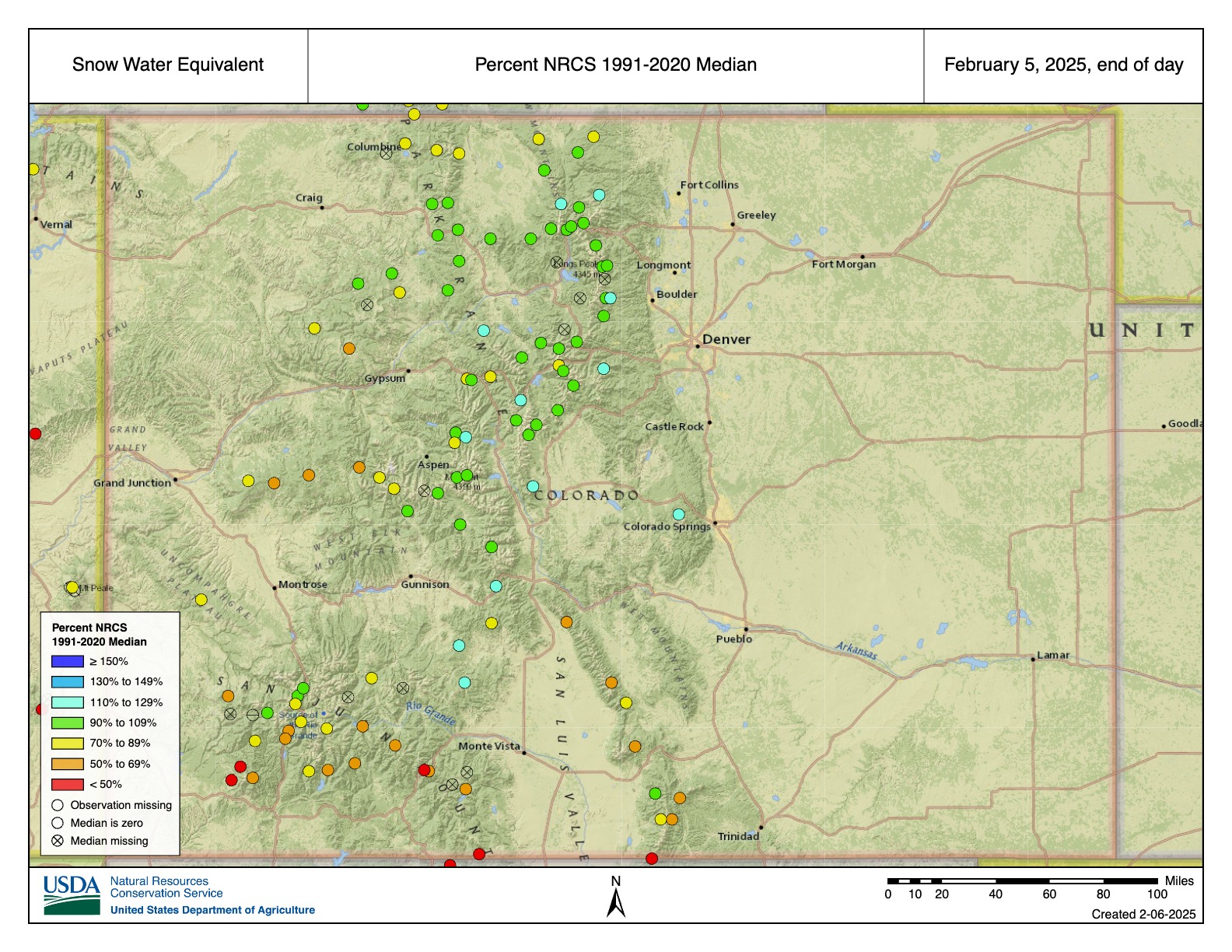
A map from the U.S. Department of Agriculture’s National Water and Climate Center shows Colorado snowpack levels as of Feb. 9, 2025, compared to the median recorded from 1991 to 2020. (Image courtesy of National Water and Climate Center)
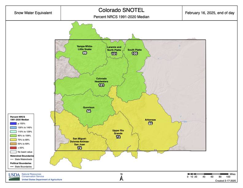
Statewide, the snowpack is at 82% of the median between 1991 and 2020. Snowpack in the mountains from near Rocky Mountain National Park to the ranges in the south near Aspen, Silverthorne and Buena Vista are generally sitting at near-to-above normal. Mountains farther south and west, however, remain much more dry. A snow observation station near Mancos is recording snowpack at 31% of normal — the lowest in the state.
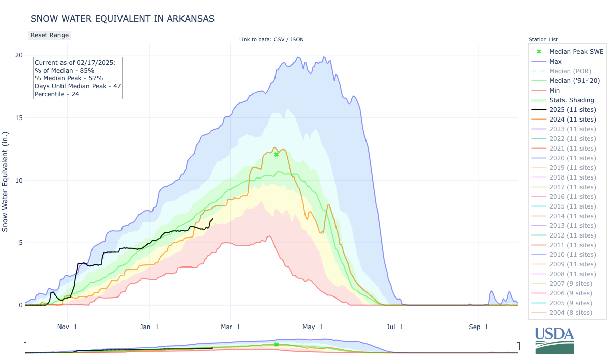
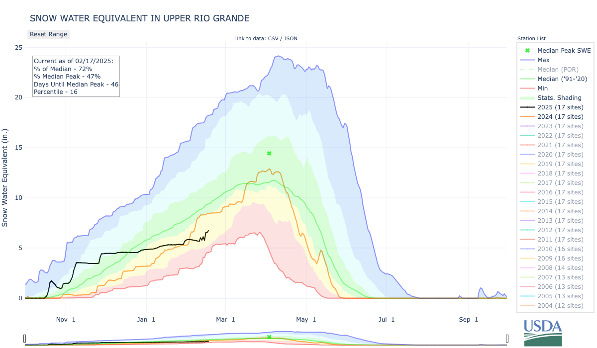
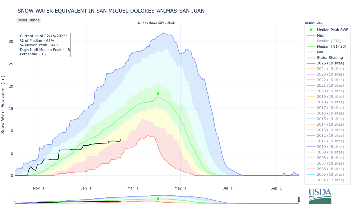
In southwest Colorado, snowpack in the San Miguel, Dolores, Animas and San Juan basins is at only 61% of median. The Upper Rio Grande Basin, similarly, sits at 64% of median.
Three of Colorado’s top water experts hammered home the idea that Colorado’s water situation id precarious, at best, and almost always on the brink of crisis. The day-long Voices of Rural Colorado symposium in Denver was the setting for an hour-long discussion of Colorado water. Attendees heard from, and interacted with, Rebecca Mitchell, former executive director of the Colorado Water Conservation Board and now Colorado’s representative on the Upper Colorado River Commission; Zane Kessler, director of government relations for the Colorado River District; and Jim Yahn, Logan County Commissioner and manager of the North Sterling Irrigation District. One of the points that was repeatedly made during the discussion was that the Colorado River is Colorado’s River. Besides watering most of the Western Slope of Colorado, the river is tapped for more than a half-million acre feet of water to the Front Range and eastern plains. Nearly half of that, about 200,000 acre feet per year, is fed directly into the Big Thompson River at Estes Park, primarily for irrigation in the South Platte River Basin. The remaining 330,000 acre feet is diverted to cities on the Front Range like Denver, Colorado Springs and Pueblo. That water ends up in the South Platte and Arkansas River basins…
Yahn told the attendees that continued drought in the Colorado River Basin will have an impact on the South Platte Valley, which is why projects like the Chimney Hollow Reservoir, nearing completion next to Carter Lake west of Berthoud, are important…Mitchell said that the crisis on the Colorado is easily seen in the water levels of the two largest reservoirs on the river, Lake Mead on the Nevada-Arizona state line near Las Vegas, and Lake Powell, halfway between Salt Lake City and Phoenix on the Utah-Arizona state line.
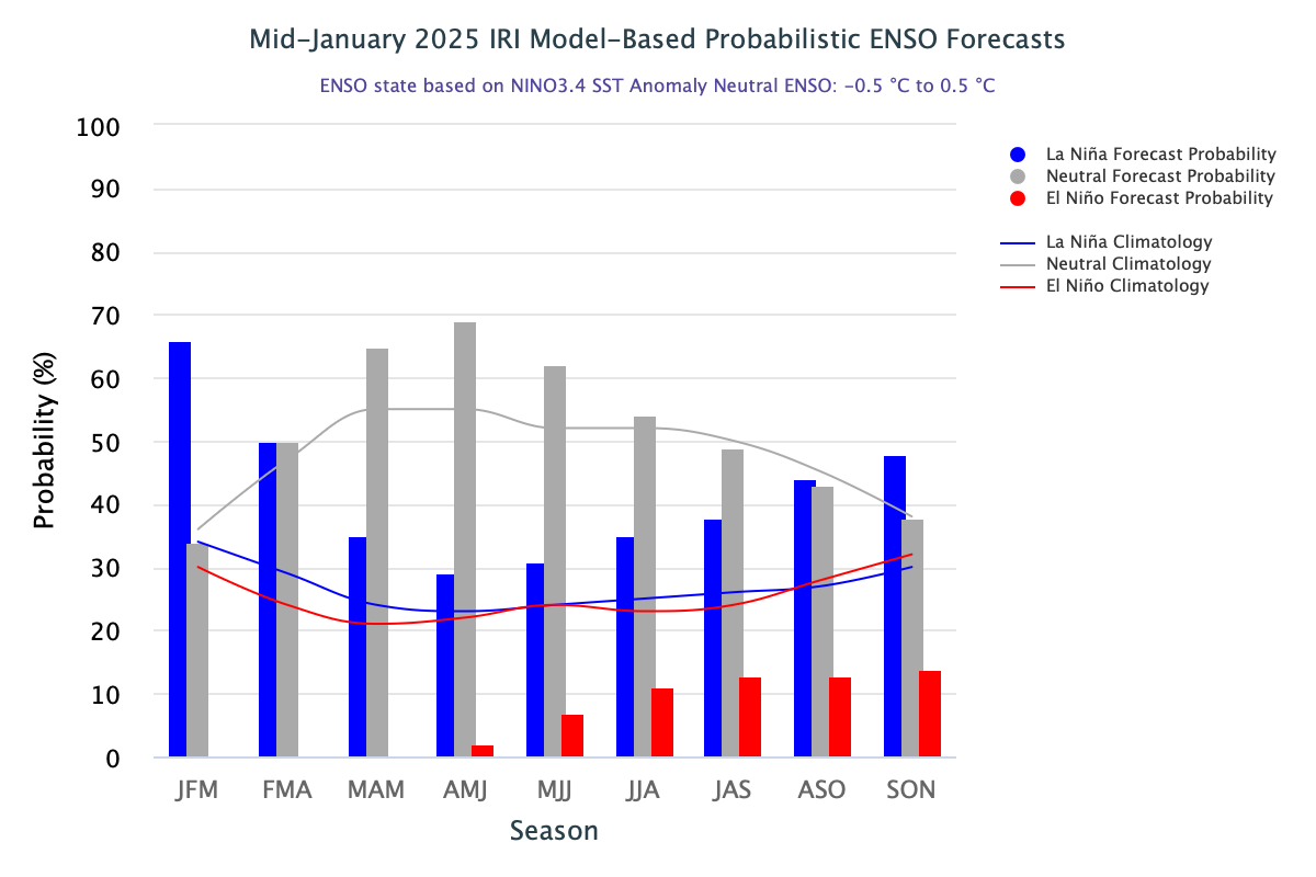
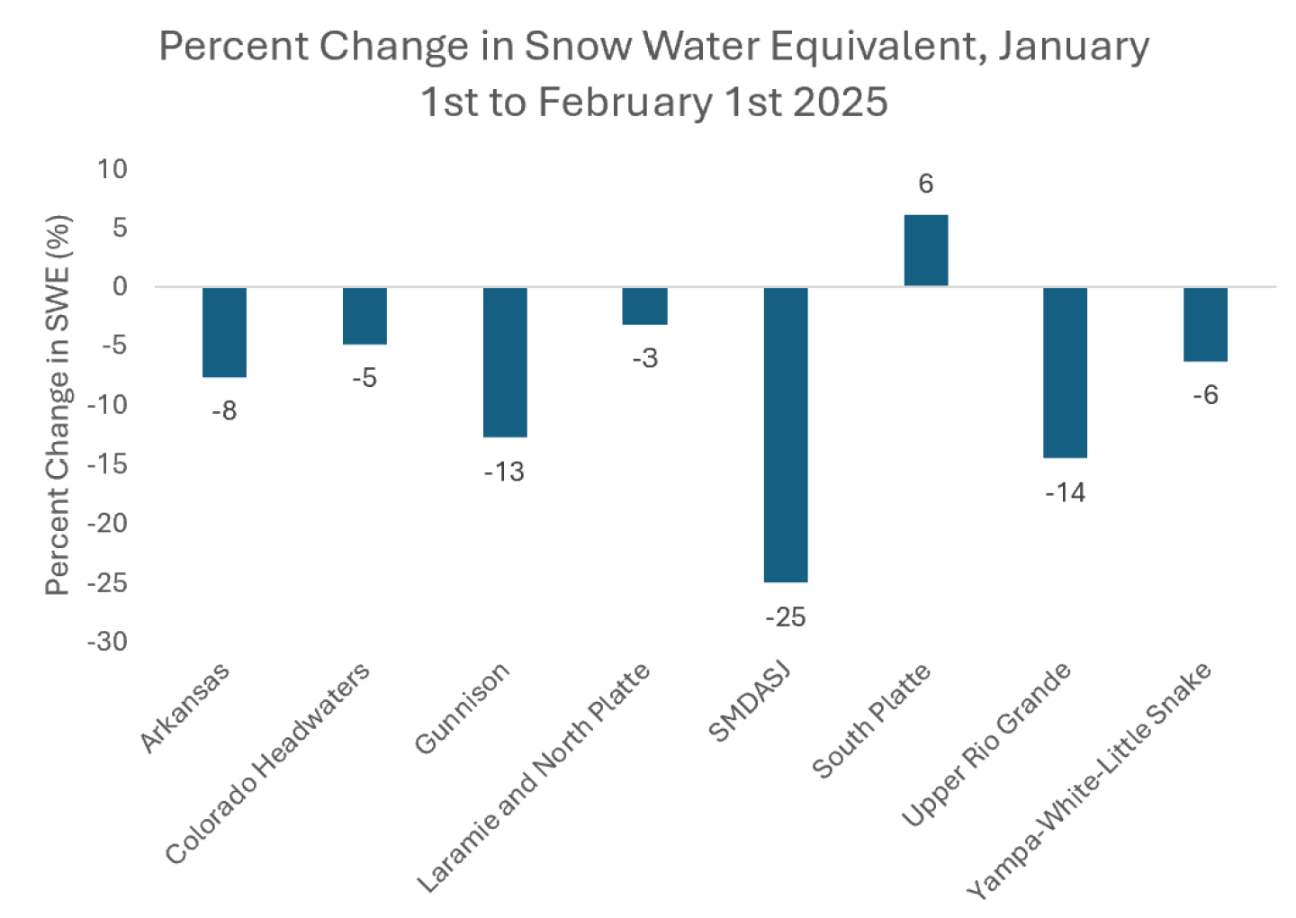
In January, precipitation varied across the region, from much below average conditions in Utah and western Colorado to much above average conditions in eastern Colorado and southeastern Wyoming. January temperatures were colder than usual, especially in Colorado and Wyoming where temperatures were 6 to 10°F below average. Snow-water equivalent (SWE) was generally below normal, particularly in southern Utah and southwestern Colorado. Seasonal streamflow forecasts for February 1st indicate below average runoff for much of the region, with the worst forecasts for Utah. Drought coverage increased across the region, affecting 56% of the region as of February 4th. La Niña conditions emerged in the Pacific Ocean but are expected to transition back to ENSO-neutral by spring 2025. NOAA seasonal forecasts for February-April suggest an increased probability of below average precipitation for the majority of the region.
January precipitation was below to much below average in Utah, western Colorado, and southwestern Wyoming, and above to much above average in eastern Colorado and central to southeastern Wyoming. Large areas of 200-400% of average precipitation occurred from Laramie County in southeastern Wyoming down to Pueblo County in southeastern Colorado, with small pockets of 200-400% of average precipitation in Natrona County in central Wyoming and Uintah County in northeastern Utah. Large areas of less than 2% of average precipitation occurred in southern Utah. Record-dry conditions occurred across Utah and in the West Slope of Colorado.
Precip_1.2025
Precip_Percentile_1.2025
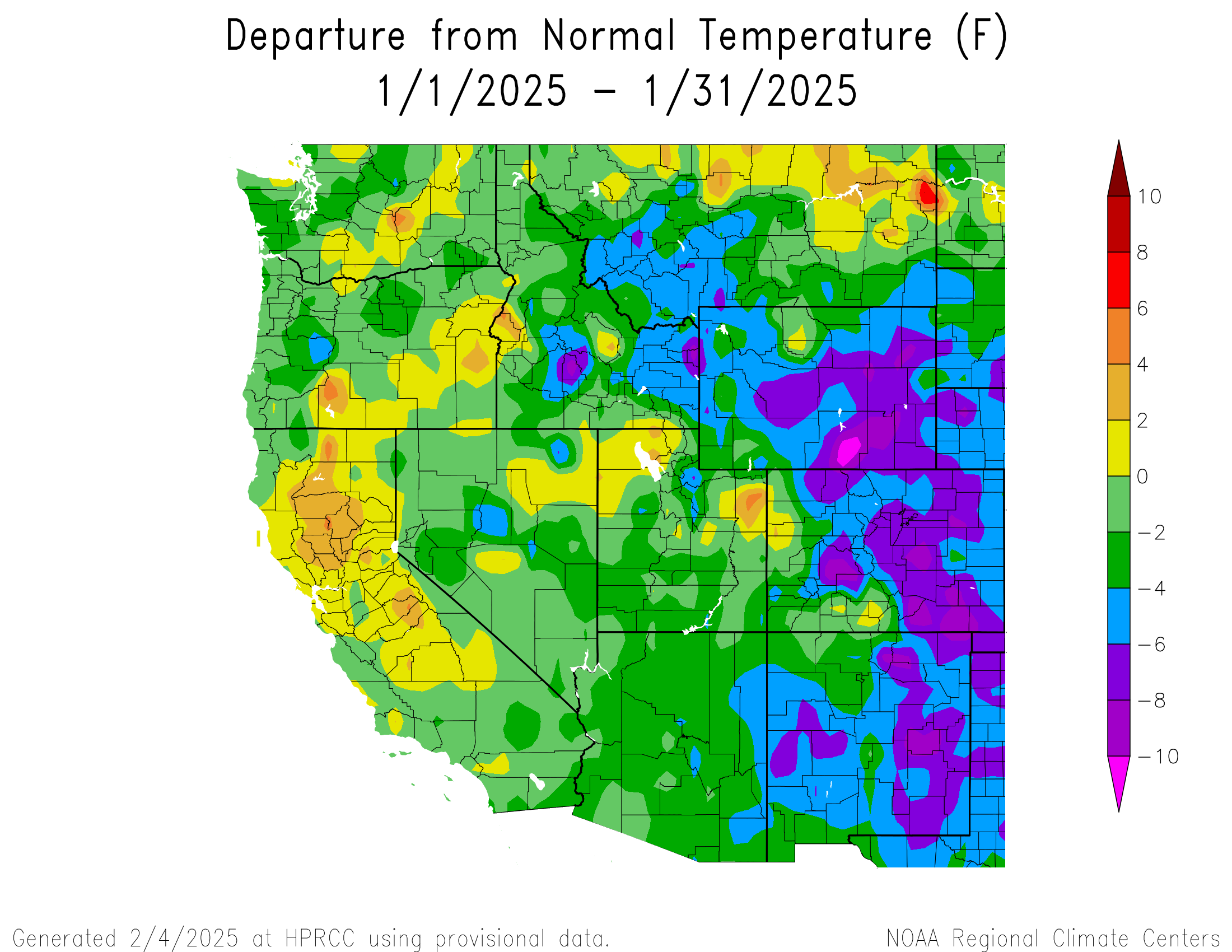
January temperatures were near to below average in Utah and below to much below average in Colorado and Wyoming. Temperatures of 6 to 8°F below average occurred throughout most of Colorado and Wyoming with scattered pockets of 8 to 10°F below average. One pocket of lower than 10°F below average temperatures occurred in Carbon County in southern Wyoming.
Temp_1.2025
temp_Percentile_1.2025
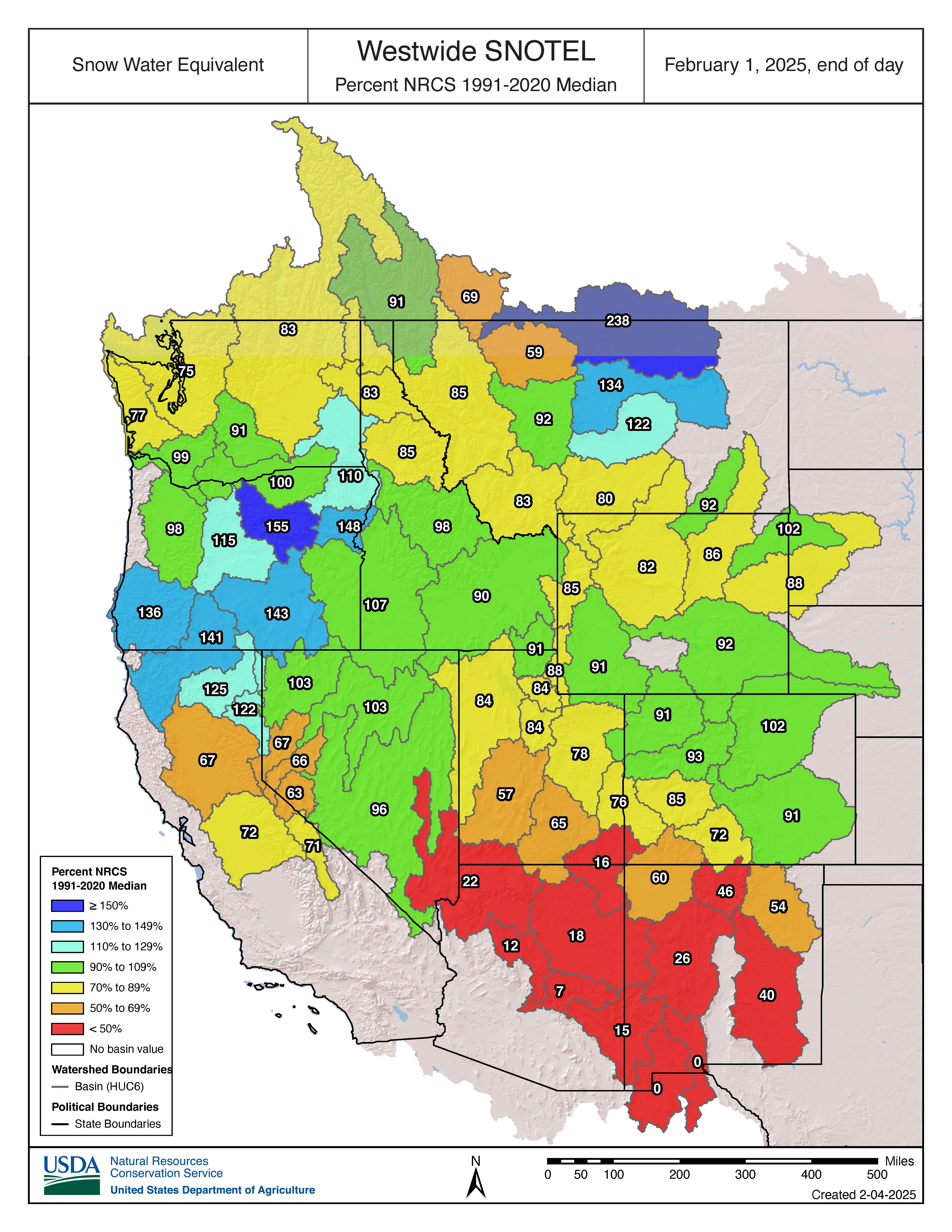
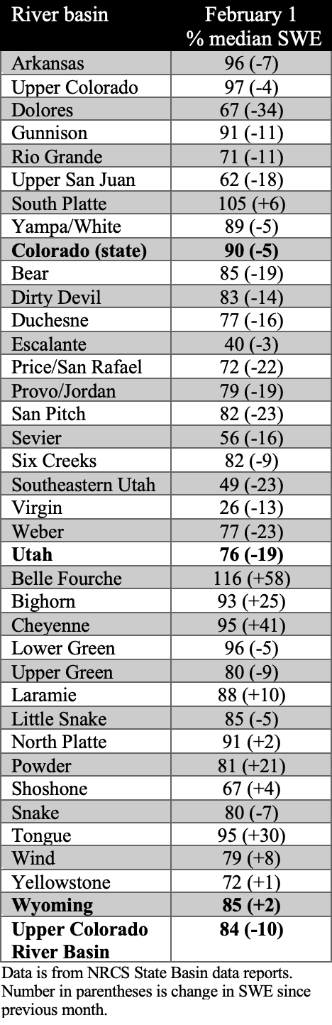
Snow-water equivalent (SWE) was near to below normal for the majority of the region, with much below normal conditions in southern Utah and southwestern Colorado. The majority of river basins in Colorado and Utah saw a significant decrease in SWE conditions relative to median during January, whereas many Wyoming river basins saw a significant increase, particularly the Belle Fourche, Cheyenne, Tongue, Bighorn, and Powder River Basins. On a statewide basis, February 1st SWE conditions in Colorado were near normal (90%) and below normal in Wyoming (85%) and Utah (76%). Southern Utah is still experiencing the worst snow drought conditions with the Virgin River Basin at 26% of normal and the Escalante River Basin at 40% of normal. According to the Real-Time Spatial Estimates of Snow-Water Equivalent (SWE) tool, all major river basins in the region have below average February 1 SWE except for the Tongue and Powder River Basins in Wyoming which are slightly above average at 113% and 108%, respectively. The Lower Colorado and Lower San Juan River Basins in southern Utah are experiencing the lowest average SWE at 4% and 1%, respectively.
swe_2.1.25
SWE_basin_020125
Real-Time-SWE_HUC_2.1.2025
February 1st seasonal streamflow forecasts suggest below average runoff throughout much of the region, with much below average runoff in Utah, and near average runoff in eastern Colorado and northeastern Wyoming. In Colorado, seasonal streamflow forecasts for the Animas, Upper Colorado, and Gunnison are below average (70-89%), and the Dolores and San Juan River Basins are much below average (50-69%). In Utah, seasonal streamflow forecasts for the Lower Green, Price, Provo, and Six Creeks are below average and the Bear, Colorado, and Weber are much below average, with exceptionally below average forecasts for the Duchesne, Sevier, and Virgin River Basins (<50%). In Wyoming, seasonal streamflow forecasts for the North Platte and Snake are below average and the Bighorn, Upper Green, Shoshone, and Wind River Basins are much below average.
Streamflow_Forecast_2.1.2025
ForecastByBasin_020125
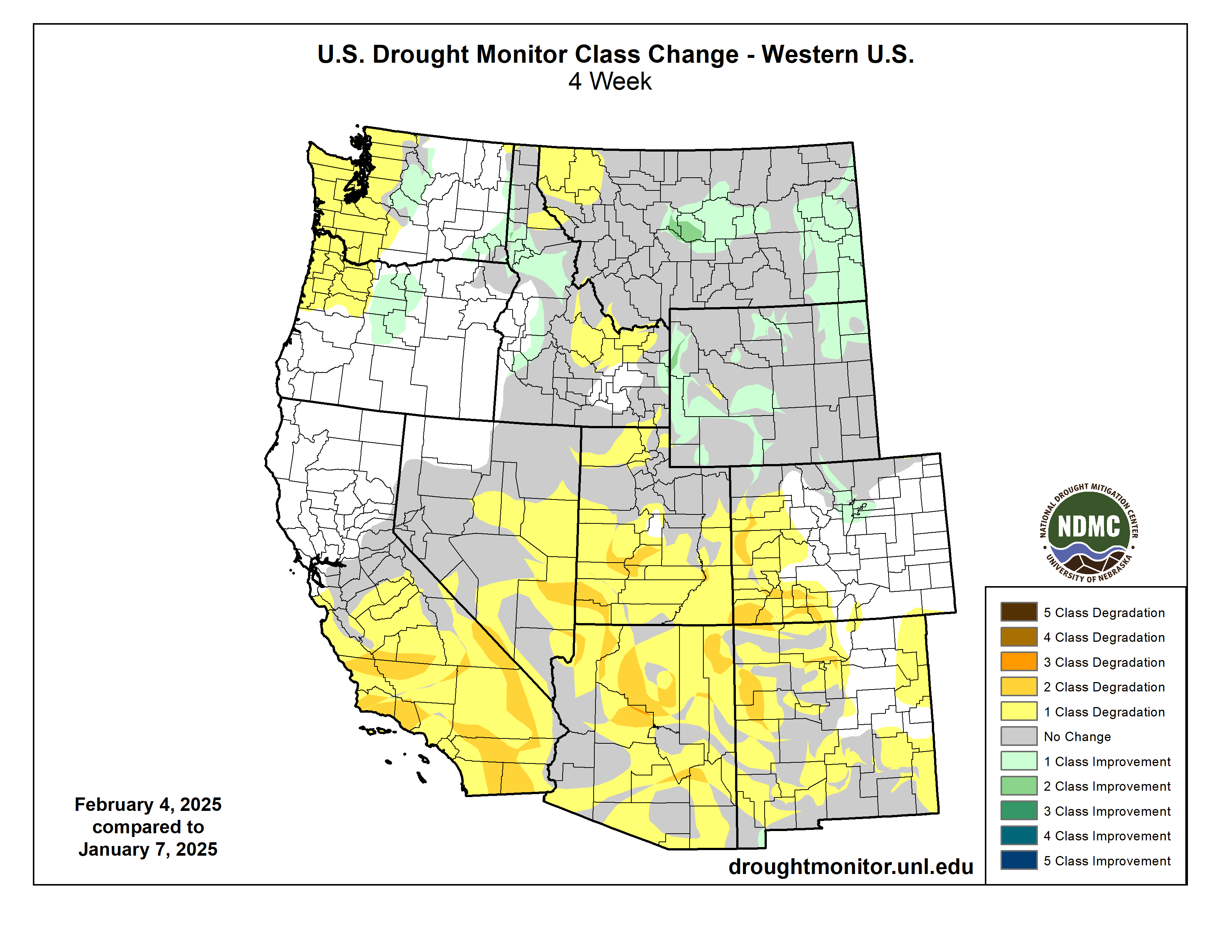
Regional drought coverage increased in January and now, as of February 4th, covers 56% of the region, compared to 39% in early January. Drought coverage nearly quadrupled in Utah and doubled in Colorado, while Wyoming saw a slight decrease in drought coverage. In Colorado, moderate (D1) drought expanded in the West Slope and severe (D2) drought developed in the southwest. In Utah, D1 drought expanded across the state, D2 drought expanded in the southwest, and extreme (D3) drought developed in the southwest. Despite Wyoming still experiencing over 80% drought coverage, there was a slight improvement in drought conditions across the state in January.
Drought_2.4.25
Drought_Change_2.4.25
After many months of ENSO-neutral conditions, La Niña conditions emerged during January. These conditions will most likely be short-lived as there is a 60-70% probability of ENSO-neutral conditions emerging by spring 2025. NOAA monthly forecasts for February suggest an increased probability of above average precipitation for northern Utah and western Wyoming, above average temperatures for southeastern Utah and southwestern Colorado, and below average temperatures for northeastern Wyoming. NOAA seasonal forecasts for February-April suggest an increased probability of below average precipitation for the majority of the region, below average temperatures for northern and eastern Wyoming, and above average temperatures for southern Utah and southwestern Colorado.
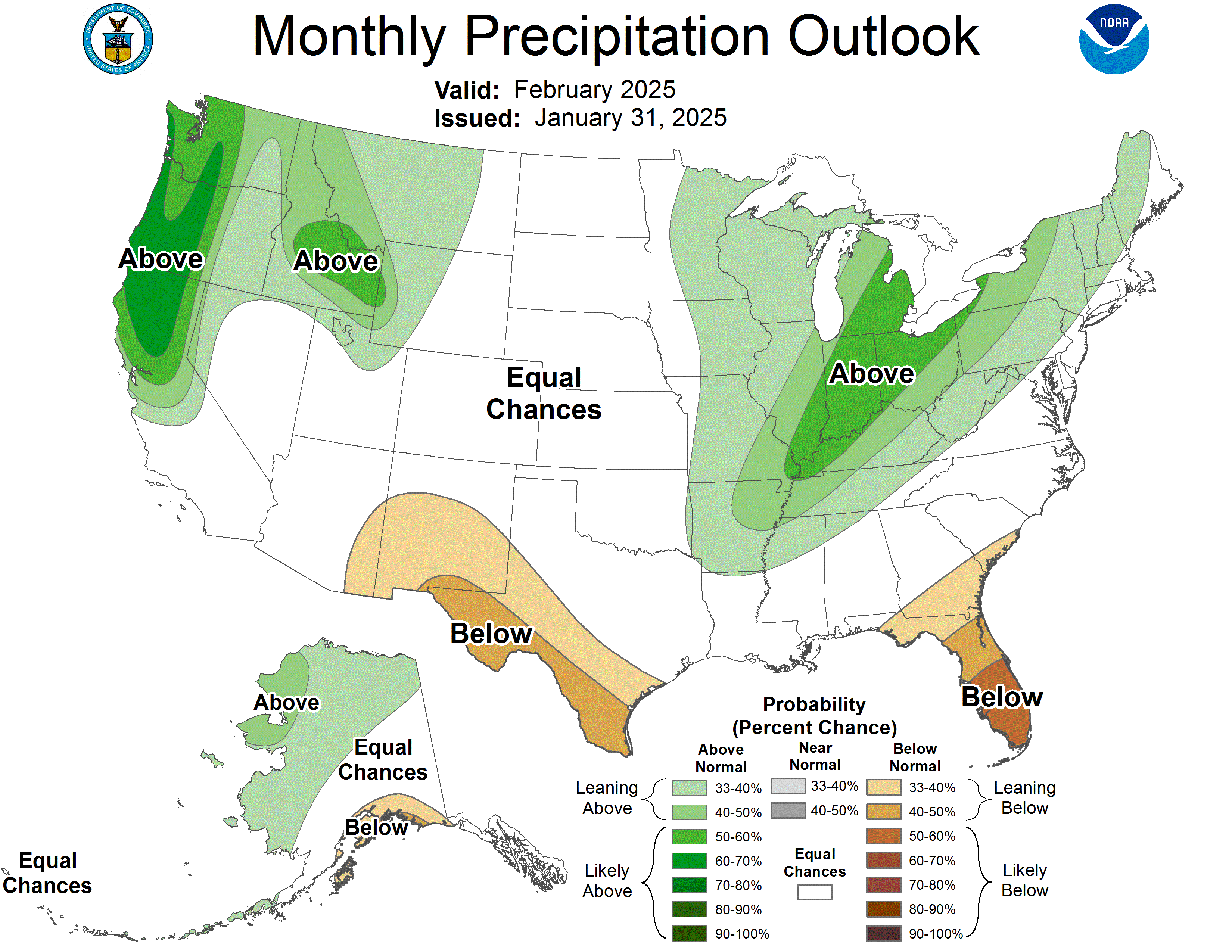
Precip_Outlook_1.31.25
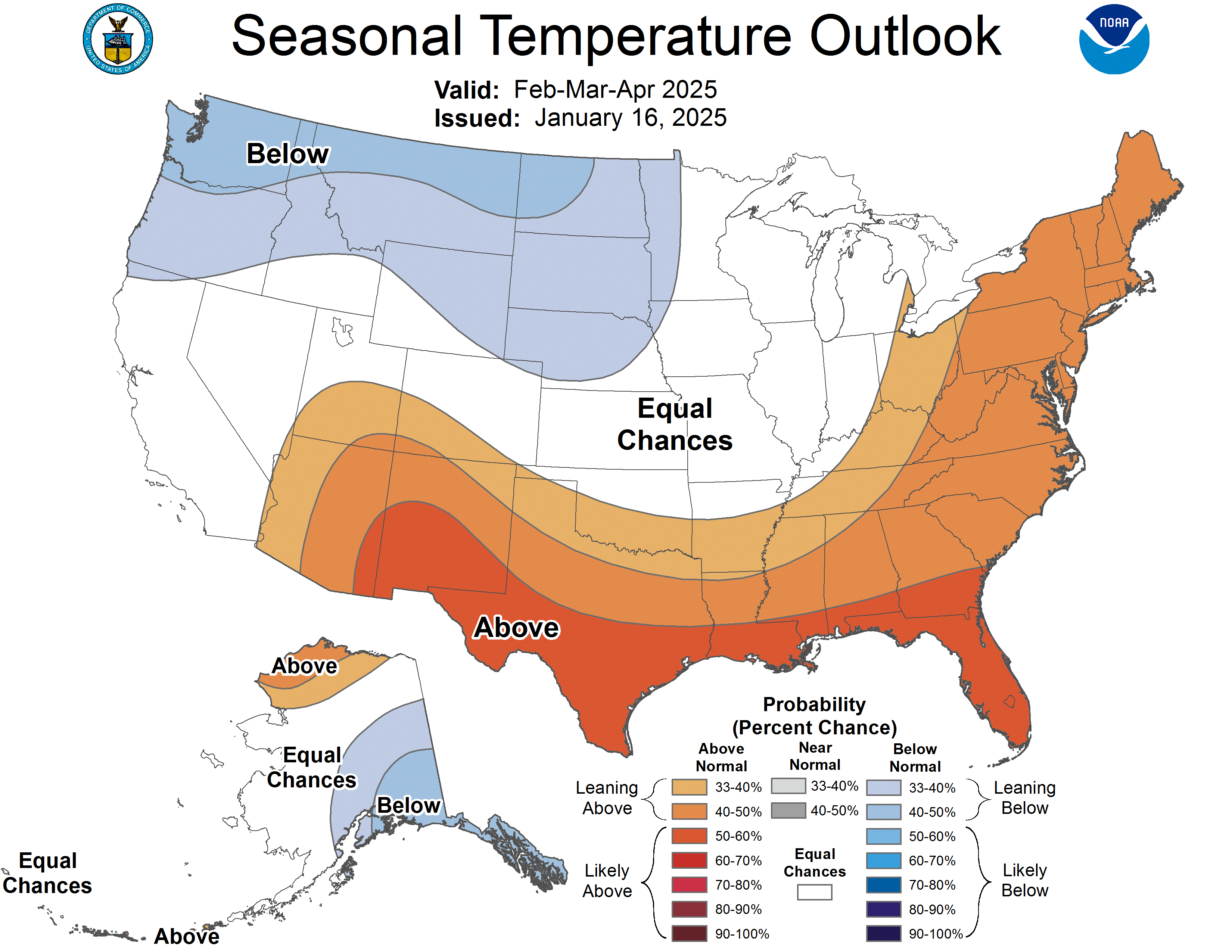
Precip_Seasonal_Outlook_1.16.25
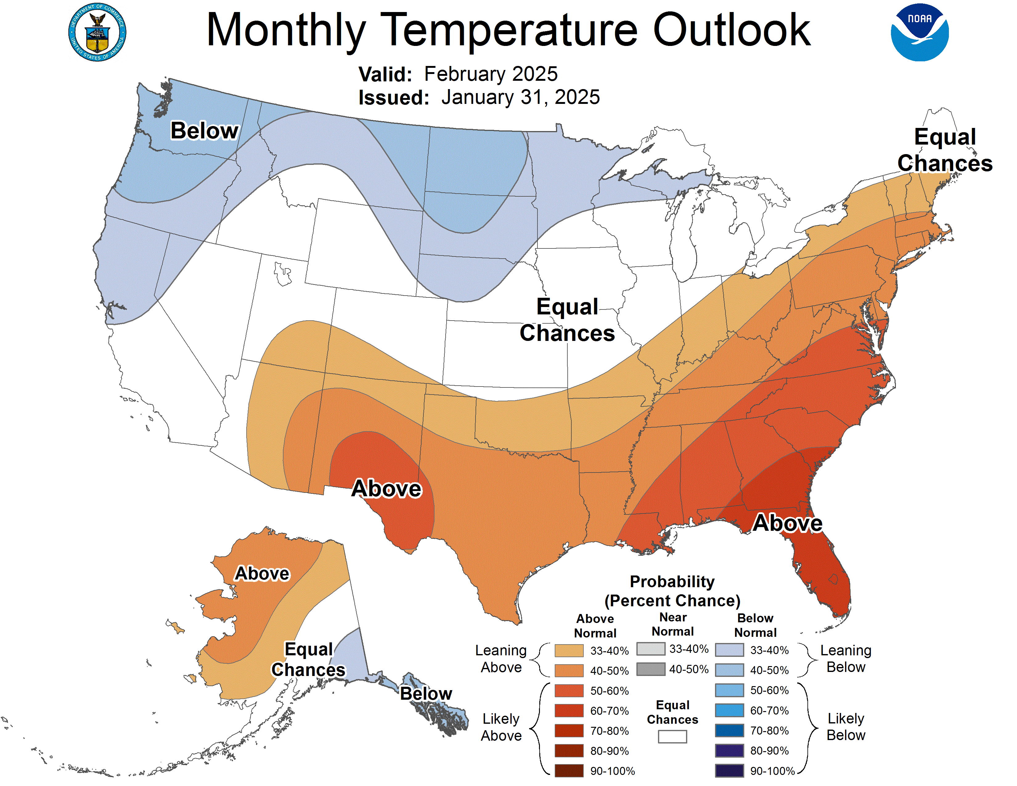
Temp_Outlook_1.31.25
Temp_Seasonal_Outlook_1.16.25
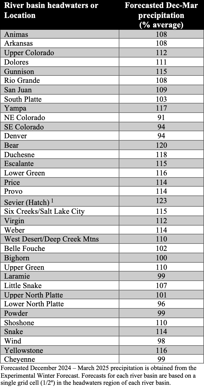
The new Experimental Winter Forecast predicts December-March precipitation in the western United States using Pacific and Atlantic Ocean temperatures. The most current forecast uses October-December ocean temperatures and indicates slightly above average winter precipitation for much of the region. The regional pattern of precipitation reflects average Pacific Ocean and warm Atlantic Ocean temperatures. Slightly above average winter precipitation is forecasted for most of the region with the highest precipitation relative to average in southern Utah and the lowest in central Wyoming and eastern Colorado.
ExpWinterForecast_020425
ExpWinterForecast_020425
Significant weather event: Polar vortex descends on Intermountain West. A severe cold wave impacted the Intermountain West on January 19-23. Winter cold waves in temperate latitudes are sometimes referred to as a polar vortex. A polar vortex is an area of low pressure and cold temperatures that always occurs around the North and South Poles. During winter, the polar vortex periodically expands in size and covers more temperate latitudes; this is the source of a cold wave, or Arctic blast in the United States. The severity of the cold wave peaked on 1/20 and 1/21 in Wyoming and Colorado, with slightly warmer temperatures in Utah. Considering weather sites with at least 50 years of data, daily minimum temperature records were set at 9% and 17% of Colorado sites and 21% and 5% of Wyoming sites on 1/20 and 1/21. Daily minimum high-temperature records were set at 17% of Colorado sites on 1/20 and 30% of Colorado sites on 1/21. Temperatures were particularly cold in the lower Arkansas River valley with record daily minimum temperatures of -19ºF in Pueblo and -22ºF in Tacony, CO on 1/21. In Colorado, -40ºF was the coldest temperature of the event, observed at Harbison Meadow near Grand Lake. In Crested Butte, -36ºF was the coldest temperature recorded since 2011. The coldest temperature observed in Wyoming, while not a daily record, was a frigid -40ºF at Old Faithful in Yellowstone, the site’s coldest temperature since 2016. The cold wave was not as severe in Utah as a whole, but a unique site at Peter’s Sink in northern Utah bottomed out at -56.1ºF. In case you were wondering, the coldest recorded temperature in the Lower 48 was -69.7ºF at Rodger’s Pass Montana; the second coldest temperature recorded was at Utah’s Peter’s Sink where temperatures dipped to -69.3ºF in 1985. For the week surrounding the cold wave, average temperatures were 15ºF to 20ºF below normal for large parts of Colorado and Wyoming with small areas up to 25ºF below normal.
Click the link to read the global climate report for January on the NOAA website:
January Highlights:
Temperatures were above average over much of the globe, but much below average over the United States, Greenland and far eastern Russia.
Eurasian snow cover extent and Arctic sea ice extent both ranked second lowest on record for January.
Global tropical cyclone activity was slightly below average with five named storms, three of which occurred in the Indian Ocean.
Temperature
The January global surface temperature was 2.39°F (1.33°C) above the 20th-century average of 53.6°F (12.0°C) and 0.05°F (0.03°C) above the previous record set last year, making last month the warmest January on record. According to NCEI’s Global Annual Temperature Outlook, there is a 7% chance that 2025 will rank as the warmest year on record.
The new January global record is particularly notable for having occurred during a La Niña episode, the cold phase of El Niño Southern Oscillation (ENSO). Global temperatures tend to be cooler during periods of ENSO-neutral conditions and even cooler during La Niña. According to NOAA’s Climate Prediction Center’s January 9 ENSO Diagnostic Discussion, La Niña conditions emerged in December 2024 and are expected to persist through February–April 2025 (59% chance), with a transition to ENSO-neutral likely during March–May 2025 (60% chance).
January temperatures were above average across much of the global land surface, particularly over Alaska, much of western Canada and most of central Eurasia. The United States, Greenland, far eastern Russia and parts of southern Africa and Antarctica were colder than average. Overall it was the warmest January on record over global land areas. Sea surface temperatures were above average over most areas, while much of the central and eastern tropical Pacific was below average (consistent with La Niña), as were parts of the southeast Pacific, western North Atlantic and the northwestern Indian Oceans. The global ocean was the second warmest on record for January.
Snow Cover
The Northern Hemisphere snow cover extent in January was the fourth lowest on record. While snow cover over North America and Greenland was slightly above average (by 80,000 square miles), Eurasia ranked second lowest on record (940,000 square miles below average). Areas of below-average snow cover stretched across most of Europe southeastward into central Asia.
Sea Ice
Global sea ice extent was the seventh smallest in the 47-year record at 6.89 million square miles, which was 1.17 million square miles below the 1991–2020 average. Arctic sea ice extent was below average (by 330,000 square miles), ranking second lowest on record, and Antarctic extent was slightly below average (by 130,000 square miles).
Tropical Cyclones
Five named storms occurred across the globe in January, which was below the average of seven. Three named storms formed in the southwestern Indian Ocean, the most impactful being Intense Tropical Cyclone Dikeledi, which made landfall on Madagascar and Mozambique, bringing high winds and heavy rains to the affected regions.
An annotated map of the world plotted with the most significant climate events of January 2025. See the story below as well as the report summary from NOAA NCEI at http://bit.ly/Global202501offsite link. (Image credit: NOAA/NCEI)
Synopsis: La Niña conditions are expected to persist in the near-term, with a transition to ENSO-neutral likely during March-May 2025 (66% chance).
La Niña conditions continued this past month, as indicated by the below-average sea surface temperatures (SSTs) across the central and east-central equatorial Pacific Ocean. The latest weekly indices were -0.6°C in Niño-3.4 and -0.9°C in Niño-4, with values close to zero in Niño-1+2 and Niño-3. Below-average subsurface temperatures persisted, with below-average temperatures dominating the central and eastern equatorial Pacific Ocean. Low-level wind anomalies remained easterly over the western and central Pacific, while upper-level wind anomalies were westerly over the central Pacific. Convection was suppressed over the Date Line and western Pacific and was enhanced over Indonesia. The traditional and equatorial Southern Oscillation indices were positive. Collectively, the coupled ocean-atmosphere system indicated La Niña conditions.
The IRI multi-model average predicts weak La Niña conditions to continue through February-April 2025 and then transition to ENSO-neutral. The IRI dynamical model average and several of the models from the North American Multi-Model Ensemble (NMME) predict an earlier transition to ENSO-neutral in January-March 2025. The forecast team favors a weak La Niña through February-April, but there is also a 41% chance of ENSO-neutral emerging in this season. A weak La Niña is less likely to result in conventional winter/spring impacts, though predictable signals can still influence the forecast guidance (e.g., CPC’s seasonal outlooks). In summary, La Niña conditions are expected to persist in the near-term, with a transition to ENSO-neutral likely during March-May 2025 (66% chance).
…lackluster January precipitation led snowpack to decline in those states. Last month, snow levels above Lake Powell were 94% of average. As of Feb. 6, snowpack fell to 83% of normal above Lake Powell…At the start of January, hydrologists predicted that spring runoff into Lake Powell between April and July would be 81% of average. Forecasters now expect runoff into the second largest reservoir in the U.S. to be just 67% of normal…The Upper Basin’s snow season is 65% complete as of Feb. 1. But the next month could bring relief, forecasters said. Lake Powell water levels have rebounded more than 40 feet since hitting a record low in 2023. The reservoir currently sits at roughly 34% full, or 3,566 feet above sea level.
Westwide SNOTE basin-filled map February 13, 2025 via the NRCS.
Conditions this week were largely based on where precipitation fell. Storms across the Ohio River Valley and Mid-Atlantic brought very beneficial rainfall, leading to improvements in eastern Oklahoma, northeast Mississippi, northern Alabama, the Tennessee-North Carolina border, Virginia and northern West Virginia. Outside of this band of precipitation in the center and eastern U.S., conditions continued to deteriorate after weeks of little to no precipitation. Many of the coastal states in the Southeast saw widespread degradation as short-term indicators show deteriorating conditions. High temperatures in many of these areas make conditions worse. Snow in the Northern Rockies and central Montana brought improvements but the rest of the West was not so lucky. Precipitation along coastal mountains kept conditions in Oregon and California unchanged, Nevada and the four-corners region saw conditions continue to deteriorate. Areas of higher elevation are seeing low snowpack for this time of year. Hawaii also saw conditions improve, while Alaska and Puerto Rico remain free of any dry or drought conditions…
The High Plains once again missed out on the precipitation that moved through the Southeast and Mid-Atlantic parts of the U.S. Western Nebraska and Kansas saw degradation as the lack of precipitation continues to affect the area. Colorado also saw degradations. In the far Northeast, abnormally dry conditions expanded from Nebraska and Kansas. Western Colorado continues to see degradations in the Western Slope and San Juan regions. Wyoming did see some extreme drought removal in the northwest and north central areas as snowpack has markedly improved in the non-mountainous areas…
Colorado Drought Monitor one week change map ending February 11, 2025.
Washington and northwestern Montana saw moderate drought expansion. Despite recent snow accumulation, they are still experiencing large moisture deficits. Conversely, central Idaho into central Montana saw widespread improvements as conditions continue to improve. Idaho has benefited from the recent snow from Boise into the Rocky Mountains into Montana. California remained unchanged this week. Conditions continue to deteriorate across the Four Corners area in the Southwest. Snowpack is below normal for this time of the year and soil moisture and streamflow levels are well below normal…
Heavy precipitation fell across western Oklahoma into Kentucky, bringing improvements to the few remaining areas of dry or drought conditions. Northwest Oklahoma saw the removal of some abnormal drought along with northeast Mississippi. Western and central Texas, Louisiana and southern Mississippi missed out on the band of heavy precipitation and saw degradations…
Looking Ahead
Over the next five to seven days, some coastal areas of the West could see precipitation from the Washington Cascades into most of California. Other higher-elevation areas in the Intermountain West as well as in the Southwest, are also expected to receive some precipitation. Heavy precipitation is expected across the South, Southeast and Northeast where amounts are estimated to reach 1.25 to 5 inches in the lower Ohio River Valley and through Alabama. Once again, much of the Plains, from North Dakota through central-west Texas, are expected to see less than a quarter of an inch of precipitation.
The 6-10 day outlook shows the greatest probability of below-normal temperatures are in the central Midwest. Below-normal temperatures are expected to be below-normal from central Montana to central Texas and all the way into Maine. The best chances of above-normal temperatures will likely be across Alaska and Hawaii. Southern Arizona and southern Florida are expected to stay near normal temperatures. The greatest chances of above-normal precipitation are expected to be across the Gulf Coast from Texas and across the Florida Peninsula. A large swath of the country (Washington towards the Gulf of Mexico) is leaning towards above-normal precipitation. Alaska is also leaning toward above-normal precipitation. Along California’s central and southern coast precipitation are expected to be drier –than normal, and to a lesser extent, Arizona, Nevada, and southwest New Mexico. The northern Midwest and Great Lakes region, along with Hawaii, are expected to have near or just below normal precipitation.
US Drought Monitor one week change map ending February 11, 2025.
Snowpack has been improving somewhat for Wyoming and northern Colorado — much of that falling in the past week. However, in the southern half of the Intermountain West, there’s a long way to go especially in Arizona and New Mexico, which was explained on the latest Intermountain West Webinar and Drought Outlook on Tuesday, Feb. 4, 2025, hosted by the National Integrated Drought Information System. The Intermountain West is made of five states — Colorado, Wyoming, Utah, Arizona and New Mexico. Thanks to recent snows, northern Colorado and Wyoming are actually having about 90 percent of median to median snowpack. That means northern Colorado and Wyoming were extremely close to being right on target for normal snowpack, thanks to their winter snowfall, so far…Meanwhile, much of southern Colorado and northern Utah have 70 to 90 percent of median snowpack…Unfortunately, that doesn’t include parts of southwest Colorado and southern Utah, which are showing a smaller snowpack with just 50 to 70 percent of median snowpack. Then, further down the list is a large chunk of Arizona and New Mexico, which have less than 50 percent of median, with much area under 25 percent of median snowpack…
So far, its been a banner winter for many parts of the Intermountain West. The official snow total for Cheyenne, Wyo., as of Feb. 5, 2025 is 16’6″. Here are other snowfall totals from CoCoRaHS (Community Collaborative Rain, Hail, and Snow Network) for the three northern states. “And, I would really stress that these are atypical and solely because of their locations, especially having to do with elevation. Totals in the 20″-50” range are much more the norm throughout the West, Bergantino said. Reports from CoCoRaHS observers are used by the National Weather Service, the National Centers for Environmental Information, engineers, farmers, teachers and many others. Smoot, Wyo., 4.9 SSE (south of Afton) — 127 inches; Crested Butte, Colo., 6.2 N (west central Colorado) — 111.8 inches; Heber City, Utah, 10.1 ESE (southeast of Salt Lake) — 107 inches Interestingly, Colorado snowfall varied almost every month from fall to current. October was mostly near normal for much of the state. November, however, was generally 400 to 600 percent of normal, especially for sites south of Highway 50, while areas to the north were more spotty, with some areas near normal and other areas above.
Feb. 10, 2025- A newly announced conservation easement will protect more than 7,400 acres in the North Fork Valley from development.
Landowner Peter Slaugh worked with the Colorado West Land Trust to permanently protect Scenic Mesa Ranch, which is south of Hotchkiss and near the confluence of the North Fork of the Gunnison River and the mainstem of the Gunnison River.
“Thanks to the commitment of landowner Peter Slaugh, this remarkable landscape will remain protected forever — ensuring its rich wildlife habitat, agricultural legacy, and scenic beauty continue to benefit the community for generations to come,” the land trust said in a news release.
The ranch includes miles along the two rivers, borders the Gunnison Gorge National Conservation Area and helps connect lower-elevation public land with the West Elk wilderness.
“The property’s scale, high-quality habitat, and strategic location make this an incredibly important conservation achievement,” Rob Bleiberg, executive director of the land trust, said in the release. “We are grateful to partner with Peter Slaugh to protect this incredibly important piece of Western Colorado’s wildlife and agricultural heritage.”
The mesa and the ranch’s riparian areas and canyons are home to wildlife such as eagles, river otters, elk, mule deer, bighorn sheep, mountain lions and black bears. Scenic Mesa also supports livestock grazing, irrigated hay production and dryland pastures, and the conservation easement permanently secures senior water rights, ensuring the land’s continued agricultural productivity and preservation of open space, the land trust said.
Slaugh said in the release, “We live in a dry climate where water is key to promoting healthy habitats. We feel honored to act as stewards of this ranch with a rich history. While raising cattle, we are equally committed to managing the health and survival of wildlife and their habitats. It’s important to us that this land remains a wildlife preserve and avoids development.”
Slaugh and the land trust plan to partner on restoration projects to improve aquatic and upland habitats, including river restoration work with the Western Colorado Conservation Corps.
According to the land trust, the conservation easement preserves the beauty of a mesa visible from Colorado Highway 92 and surrounding public roads. The land also is adjacent to more than 13,000 acres of conserved land and near public lands, further enhancing its value as an ecological asset.
The nonprofit Colorado West Land Trust, based in Grand Junction, has conserved more than 144,000 acres in Delta, Gunnison, Mesa, Montrose, Ouray and San Miguel counties.
Cosmos in full-summertime bloom in the North Fork Valley in October 2024. Jonathan P. Thompson photo.
An Airborne Snow Observatories plane prepares for a flight to survey a watershed using lidar technology. Data from the flight will be used to produce snow depth, snow water equivalent and snow albedo maps all to enhance the accuracy of summer runoff forecasts.
Airborne Snow Observatories/Courtesy illustration
House Bill25-1115, a bipartisan proposal from a group of Western Slope lawmakers that would create a new statewide snowpack measurement program using emerging tools like light detection and ranging technology, also known as lidar.
“This is a way for us to plan better in our storage facilities, in our reservoirs,” said House Speaker Julie McCluskie, a Dillon Democrat and a prime sponsor of the bill.
The mountain ranges above Dillon Reservoir, seen through the lens of the data collected by sophisticated equipment onboard a plane that flew over the Blue River Basin to measure the amount of water frozen in the snow above Denver Water’s largest reservoir. Image credit: Airborne Snow Observatory Inc.
Like radar, but using light, lidar sends beams from a plane or satellite towards the ground. By measuring the time it takes for the light to be reflected, scientists can calculate the depth of an area and create a 3-D model of the landscape. The flights also use a spectrometer to capture infrared images that show where snow is melting fastest. Glenwood Springs-based scientist Jeff Deems and his team pioneered the technology for snowpack mapping with the National Aeronautics and Space Administration in 2013. From those efforts, Deems co-founded Airborne Snow Observatories, a public benefit corporation that contracts with local and regional governments and water providers. Using a fleet of twin-engine planes equipped with lidar, the group runs flights to map river basins across the West. Deems said lidar isn’t replacing SNOTEL, which remains the backbone for snow monitoring by providing a decades-long record of changes in snowpack. Instead, lidar is helping fill in the gaps. While SNOTEL sites pinpoint data at specific locations, lidar provides a full picture of the entire watershed.
“The combination of the two gives us this really powerful 4D picture of a basin-wide snowpack,” Deems said. “We get the three dimensions from airborne surveys and the ‘time’ dimension from the SNOTELs, and that really gives us the best knowledge from which to anticipate and forecast our summer runoff.”
GLENWOOD SPRINGS, Colorado — The Colorado River District’s Board of Directors held its first quarterly meeting of the year on Jan. 21-22 and approved $480,000 in Community Funding Partnership grants to support water projects across the Western Slope. A highlight in this round of funding is a $300,000 grant to the Colorado Mesa University’s Ruth Powell Hutchins Water Center to support the Center’s growth over the next three years, including hiring an executive director and establishing a long-term growth strategy for the organization. The River District funding award will be matched by $ 300,000 from Colorado Mesa University.
The grant and partnership with CMU will strengthen the Water Center’s ability to serve as a West Slope hub for water policy and academic education, fostering leadership and innovation in water resource management. The funding will also support strategic planning and program expansion, positioning the West Slope as a central source of research, collaboration, and leadership in Colorado’s River.
“Supporting the CMU Water Center is an investment in the expertise and leadership needed to secure Western Colorado’s water future,” said Colorado River District General Manager Andy Mueller. “CMU has long been a trusted leader in West Slope education and data-informed research. This partnership empowers local knowledge and innovation and will create future generations of water leaders in the Colorado River.”
“At CMU, we take pride in being a voice for Western Colorado, and we see the Water Center as central to that mission,” said Colorado Mesa University President John Marshall. “With this investment from the Colorado River District—matched by CMU—we are establishing a strong, foundational hub for water research and policy rooted in Western Slope expertise, helping students and professionals drive solutions for our region’s water future.”
In addition to the CMU Water Center grant, the Board approved $180,000 in Community Funding Partnership grants for critical water projects across the Western Slope. An $80,000 grant will support the Terror Ditch Pipeline Project in Delta County, piping just over a mile of ditches to reduce water loss and mitigate infrastructure collapse risks, benefiting over 500 acres of agricultural land in the Gunnison Basin. Another $100,000 grant will fund the Upper Yampa Watershed and Stagecoach Reservoir Water Quality Model Project in Routt County, which will develop decision-making tools to address harmful algal blooms and improve water quality in the Upper Yampa River Basin.
The Community Funding Partnership, launched in 2021, is designed to support the development of multi-benefit water projects across Western Colorado. To date, the program has funded over 130 projects and leveraged nearly $100 million in funding for projects that benefit agriculture, infrastructure, healthy rivers, watershed health and water quality, and conservation and efficiency.
For more information on the Colorado River District’s Community Funding Partnership and how to apply for future funding opportunities, visit www.ColoradoRiverDistrict.org.
Glenwood Springs homeowners Ginny and Jim Minch replaced their lawn with drought-tolerant plants and decorative rocks using a rebate program through the city of Glenwood. Colorado lawmakers have introduced another bill this session taking aim at thirsty turf as a way of conserving water. Credit: Heather Sackett/Aspen Journalism
Colorado lawmakers want to add more restrictions on thirsty grass in new residential developments in an effort to conserve water.
House Bill 1113 would limit planting non-functional turf, artificial turf or invasive plant species in new and redeveloped apartment or condominium housing. This year’s bill is an extension of last year’s Senate Bill 5, which requires local governments by Jan. 1, 2026, to establish policies prohibiting the planting of nonfunctional turf as part of any new development or redevelopment alongside roads and streets or in medians, as well as in areas surrounding offices or other commercial buildings, in front of government buildings, and in entryways and common areas managed by homeowners associations.
Under HB 1113, local governments would also have to enact their own policies about how to limit new turf on properties not covered by either of the two state bills by 2028.
The bill represents a continuing effort across the Colorado River basin to wring savings from municipal water use in the face of a warming and drying climate. State Sen. Dylan Roberts, who represents District 8, is a sponsor of the bill, along with representatives Karen McCormick and Lesley Smith, all Democrats. Roberts, whose district includes Garfield, Routt, Summit and Eagle counties, said the bill was born out of a general desire to conserve water.
“Whether it’s ongoing drought that is putting a strain on our water supply, negotiations over interstate compacts like the Colorado River or population growth, there’s just a lot of demands on Colorado’s water,” Roberts said. “Water that’s being used for non-functional turf is a pretty obvious place to look for water savings.”
The prohibition on new grass is not aimed at lawns for single-family homes, parks, playgrounds or sports fields. Non-functional turf is defined as grass that is not used for civic, community or recreation purposes. Often planted alongside roads or sidewalks, medians or around offices, commercial or government buildings, it is purely ornamental and the only person who ever walks on it is pushing a lawnmower.
In recent years, municipalities and urban water providers have focused on thirsty Kentucky bluegrass as low-hanging fruit in reducing outdoor water use. Outdoor water use can be the biggest factor in a development’s water use overall. Voluntary turf removal incentives have grown in popularity, with lawmakers creating a state funding source in 2022 for property owners to replace lawns with less water-intensive landscaping. A 2023 statewide drought task force also recommended to the legislature that they continue to fund turf removal programs.
Rep. Karen McCormick, whose district includes Boulder County, said the second part of the bill that requires local entities to enact their own regulations on turf is a nod to local control. Those regulations could include limiting new turf planted around single-family homes, as a handful of municipalities, including Aurora and Castle Rock, have done.
“We’re not telling the local entities how to do that or what to do, but to do this your way that works for your community and your county, your city,” McCormick said. “We’re just saying, please look at how you are allowing high-water-use turf and please sit down and address how you can be part of the solution.”
Real estate developers in Aurora typically created lavish areas devoted to turf along streets, including this one, but a 2022 law dramatically reduced what is permitted in future developments.
CREDIT: ALLEN BEST/BIG PIVOTS
Environmental groups like Conservation Colorado, Western Resource Advocates, the Sierra Club and 350 Colorado are supporting the measure.
Chelsea Benjamin, a policy advisor at WRA, said the organization is supporting HB 1113 to build on the statewide progress over the past few years toward more water-wise landscaping.
“Especially in the context of Colorado becoming a hotter and drier place, our resources are getting stretched thin,” Benjamin said. “There have been a lot of efforts to date to focus on water conservation because we know that it’s the cheapest, fastest and most reliable way to help our communities thrive in this new reality.”
The place where HB 1113 may be most effective is in fast-growing Front Range cities. Several large municipal water providers on the east side of the Continental Divide are monitoring the legislation as it makes its way through the state House and Senate, including Denver Water, Colorado Springs Utilities and Aurora Water, which together serve about 2.4 million residents.
Colorado Springs, like some other communities around the state, is already addressing turf in its land use code. According to Julia Gallucci, water conservation supervisor for CSU, the city of Colorado Springs, which is a separate entity, would need to make only minor tweaks to its land use code to be in compliance with state rules. In Colorado Springs’ 2023 land use code update, new construction projects are limited to 25% turf in any irrigated areas.
For cities, reducing outdoor water use is key to meeting conservation goals and stretching existing water supplies. Gallucci said that outdoor watering accounts for 40% of Colorado Springs’ total use system wide.
“Water is a limited resource,” Gallucci said. “We are a water-depleted state and we are a growing city so we have to do our part.”
The lone group opposing the bill as of Wednesday was Colorado Counties, Inc., which represents all of the state’s 64 counties. Reagan Shane, CCI’s legislative and policy advocate, said that while many county representatives, especially those on the Western Slope, supported the idea of water conservation, more than 65% of the state’s counties voted to oppose the bill.
“We just don’t even know that it’s something we can police,” Shane said. “How do we pass regulations that we can’t functionally police and what are the implications of that and is that good governance?”
The National Association of Landscape Professionals, GreenCO and the Synthetic Turf Council are looking to amend the bill.
John McMahon is CEO of Associated Landscape Contractors of Colorado, which is one of the seven organizations under the umbrella of GreenCO. He said his group is hoping to amend the bill so that certain species of less-thirsty grass are excluded from the definition of “turf.”
“We are looking for exemptions for new species of hybridized turf available out there,” McMahon said. “Our overall view is the right turf for the right climate and certainly the right part of the yard. We don’t agree with having Kentucky bluegrass everywhere either.”
HB 1113 is scheduled for a hearing before the House Agriculture, Water & Natural Resources Committee on Feb. 20.
View toward the Abajo Mountains and portions of the Indian Creek grazing allotment. Photo credit: LandDesk.org
Click the link to read the article on the LandDesk.org website (Jonathan P. Thompson):
February 7, 2025
🌵 Public Lands 🌲
The News: Last week, administrative judge Dawn Perry halted the Bureau of Land Management’s approval of The Nature Conservancy’s plan to build 13 reservoirs and erect five fences on the Indian Creek grazing allotment within Bears Ears National Monument. Perry ruled in favor of Western Watersheds Project,Jonathan B. Ratner, and Sage Steppe Wild, who had appealed the approval, and found that the agency had failed to adequately analyze impacts of the plan.
The Context: The Indian Creek allotment and the Dugout Ranch that runs cattle on it are integral to the West’s ranching history, and a perfect example of how public land grazing is complicated as an environmental issue, and how a certain sentimentality shades society’s — and land management agency’s — views of it.
The ranch is probably one of the more spectacular chunks of private land in the West, covering 5,000 acres in the Indian Creek drainage adjacent to the Needles District of Canyonlands National Park and surrounded by towering Wingate sandstone cliffs and formations. It was first settled by white folks in the 1880s, although BLM records suggest the homestead wasn’t patented until 1915 by David Cooper.
Three years later Al Scorup — known as the “Mormon Cowboy” — and his brother Jim teamed up with Moab’s Somerville family to purchase the Indian Creek Cattle Company and the Dugout Ranch. They had a rough go of it: cattle prices crashed, the Spanish Flu killed Jim and his wife, and a hard winter killed 2,000 head of the company’s cattle.
But the Mormon Cowboy held on and by 1927 had permits to graze 6,800 cattle on U.S. Forest Service land, more than any other permittee in the nation. In 1936, two years after the Taylor Grazing Act was passed, Scorup’s company recorded 4,000 or so cattle on federal Grazing Service (now BLM) land, including in Beef Basin, Dark Canyon, White Canyon, and Grand Gulch.
In 1965, a year after Congress designated Canyonlands as a national monument, Charlie Redd acquired the Scorup-Somerville Cattle Company, which included the Dugout Ranch and its associated grazing leases.1 Soon thereafter, Redd’s son Robert, along with his wife Heidi, took over the ranch. Heidi Redd, legendary in southeast Utah and beyond, sold the ranch to the Nature Conservancy in 1997, though she continued to operate the ranch until her son and daughter-in-law took over. In 2016, then President Barack Obama designated the Bears Ears National Monument, which included the entirety of the 272,000-acre Indian Creek allotment.
For some folks it might seem strange that an environmental group, The Nature Conservancy, is running cattle on a national monument — especially in Utah’s high desert, where the land is especially fragile and cultural sites are plentiful. After all, green groups aren’t taking over oil and gas wells and trying to run them in a more environmentally-friendly way.
But this is part of the $9.9 billion nonprofit corporation’s method. Rather than taking land out of livestock production, TNC looks to work with folks in the “beef supply chain to adopt a sustainability framework that keeps grasslands ecologically intact and economically productive, safeguarding the future ranching families and feeding a growing world.”2 Meanwhile, by acquiring the Dugout Ranch, it saved it from being developed as a desert glamping resort or some billionaire’s hideaway — triggering the “I’d rather see a cow than a condo” meme — and also established the Canyonlands Research Center there, which studies climate change and works to develop sustainable grazing practices.
Of course, many biologists and environmentalists would say that the only sustainable way to graze public lands is not to do it at all. In theory, TNC could have purchased the ranch, continued to run cattle (albeit far fewer) on private land, and bought out the public land grazing permits and retired them, as the Grand Canyon Trust did in Grand Staircase-Escalante National Monument in the late 1990s.3
The Conservancy’s Dugout Ranch’s Indian Creek permit is for just over 8,500 animal unit months, meaning they can run about 1,000 cows on the allotment from early October to mid-June. While the allotment is vast, the sections in the Dark Canyon and Beef Basin areas are harder to access, so grazing is more intensive in the 56,000 acres of pastures surrounding the private ranch. In 2018, the ranch proposed constructing 13 reservoirs, one well, and five fences on those public land pastures in an effort to distribute the cattle more evenly across the parcel and take some pressure off existing water sources, such as Indian Creek and in Davis and Lavender Canyons. It also aimed to increase livestock productivity and “improve grazing management in changing climate conditions.”
Last year the BLM approved the project (minus the well), saying it would spread the cattle out and lessen their impacts, thereby protecting the recognized “objects” of the national monument. The agency’s review, and justification for the approval, emphasizes TNC’s intent to graze its cattle sustainably and its diligence in controlling its cattle, almost as if this is a reason to approve the project, regardless of impacts. However, BLM emails obtained by Ratner show that the agency scolded the ranch for allowing cows to graze off-season in the Dark Canyon and Beef Basin areas, resulting in springs being “heavily trampled,” calling it a “livestock trespass situation,” and urging TNC to more diligently control their cows.
Western Watersheds, Sage Steppe Wild, and Ratner appealed the approval, arguing that the BLM had failed to take a hard look at potential impacts. “How would bulldozing 13 reservoirs for the sole benefit of the private interests of a massive corporation protect, preserve and restore the Bear’s Ears landscape?” Ratner wrote in his appeal. The foundational problem, he argued, is that the number of cattle exceed the pastures’ carrying capacity, not uneven distribution of cattle, and implementing the project as a solution was equivalent to putting “a tiny band aid on multiple gunshot wounds.”
The project might keep the cattle from concentrating in one area, but it would also broaden the area of impact to parts of the pasture that may have seen little grazing. The BLM predicted that the reservoirs’ construction would destroy valuable biocrusts and native vegetation, and that subsequent grazing would lay waste to everything within a 50- to 300-foot radius from each reservoir. But Western Watersheds pointed out that the BLM’s basis for this finding is shaky, and that most peer-reviewed research has found that grazing’s impacts extend for one to two miles from a water source.
Furthermore, the appellants argued, the BLM provides no evidence that building new water sources will reduce impacts on or lead to the restoration or healing of the existing water sources.
In a written statement, Laura Welp, of the Western Watersheds Project, pointed out that BLM signs and literature warn recreationists not to “bust the crust,” yet in giving grazing a virtual blank check, the agency is ignoring the impacts a thousand half-ton bovines have on the fragile soil, native vegetation, and cultural resources.
The Department of Interior’s administrative judge, largely agreed with the appellants, finding that the agency’s environmental review included “barely any rangeland health data specific to the pastures or locations where the new reservoirs and fences will be constructed.” She put a stay on the approval and the project, which doesn’t necessarily kill the project, but does require the agency to redo its review.
“Given that the only stated purpose in the EA for constructing thirteen reservoirs and five fences is to redistribute livestock, BLM had an obligation to analyze how optimized livestock distribution would impact rangeland health,” Judge Perry wrote in her ruling. “When viewed together, the immediate and irreparable impacts associated with construction activities, concentrated use, and livestock redistribution support the imposition of a stay.”
Buried within the Trump administration’s “unleashing American energy” executive order was a mandate for the Interior Department to “review and, as appropriate, revise all withdrawn public lands, consistent with existing law, including 54 U.S.C. 320301 and 43 U.S.C. 1714.”
It so happens that 54 U.S.C. 320301 is the Antiquities Act. So this means that all the national monuments created by presidents under the law — and not later designated by Congress — are in play. This could mean that Trump will try not only to shrink Bears Ears and Grand Staircase-Escalante National Monument, but could bring his illegal monument wrecking ball to places like Aztec Ruins, Hovenweep, Natural Bridges, and even Devils Tower national monuments.
I’m thinking that it probably won’t go that far. Trump is motivated by spite and revenge, and I doubt he has any bone to pick with ol’ Warren G. Harding4, who established Hovenweep and Aztec Ruins national monuments in 1923, or Teddy Roosevelt, who established Devils Tower and Natural Bridges national monuments in 1906 and 1908, respectively.
But I’m not so optimistic about the fate of Bears Ears, GSENM, and Baaj Nwaavjo I’tah Kukveni-Ancestral Footprints of the Grand Canyon National Monument. Still, it’s not worth freaking out about this yet, since we don’t know what Interior Secretary Doug Burgum might do on these things. Plus, any reduction of the monuments is very vulnerable to legal challenges, since they would be, well, illegal. There’s plenty of other outrageous things the administration — and Elon Musk — are actually doing now that are worth freaking out about.
I’ve been doing a lot of that lately — freaking out, that is — but also trying not to be overwhelmed by the firehose of absurdity, much of which is mere bluster aimed at distracting us from the real damage being inflicted or simply to aggravate the “libs.”
And damage is being done, from the attempted purge of federal employees (including a freeze on federal firefighter hiring); to canceling diversity, equity, and inclusion programs along with environmental justice initiatives; to the spending freeze on Infrastructure and Inflation Reduction act funds, which threatens to crush nonprofits and kill programs aimed at helping low- and moderate-income folks, small businesses, and farms install rooftop solar.
A lot of people are going to lose jobs, and the nation will be irreparably harmed if Musk’s rampage isn’t stopped soon. Meanwhile, eggs and energy won’t be any cheaper. The only thing you can count on is that billionaires and corporations will pay less in taxes.
🦫 Wildlife Watch 🦅
A monarch butterfly in Grand Staircase-Escalante National Monument. Jonathan P. Thompson photo.
I really hate to be the bearer of bad news, especially in these f#$%ed up times. But here it is: the annual Western Monarch Count reported a peak population of just 9,119 of the butterflies this winter, the second lowest overwintering population recorded since tracking began in 1997.
The population’s size is extremely concerning,” said Emma Pelton, an endangered species biologist with the Xerces Society for Invertebrate Conservation, in a written statement. “We know small populations are especially vulnerable to environmental fluctuations, and we think that’s what happened this year. The record high late summer temperatures and drought in the West likely contributed to the significant drop-off we saw in the third and fourth breeding generations.”
The good news is that it could be an anomaly. The last three years’ counts recorded 200,000 butterflies. The monarch is being considered for protections under the Endangered Species Act, which might help. Of course, you know who’s administration is the decider on that one, so …
It’s safe to say there is some serious weather whiplash going on all over the West. Southern California caught fire; now it’s getting deluged by atmospheric rivers. Southwest Colorado was slammed with snow in October and November; then suffered from an unusually dry December and January (I just received news that the Durango Nordic Center near the base of Purgatory Resort is shutting down until further notice due to lack of snow). This was the hottest January globally on record; but it was downright arctic in parts of Colorado (Durango had three successive nights of -10° F lows, daily records). And now the February thaw has set in, with record daily high temperatures being recorded from Grand Junction (71°), to Bluff (68°), to Albuquerque, to Denver (68°), to Phoenix (86°), to Las Vegas (80°), which hasn’t seen measurable precipitation for months.
Meanwhile, at Big Sky ski area in Montana, a sizable in-bounds avalanche broke loose during mitigation work (when the slopes were closed) and partially buried a lift terminal building.
Just some songs for your listening pleasure for these messed up times…
1 Grazing is generally banned in national parks, but in Canyonlands it was allowed to continue for 11 years after the park’s establishment, or until 1975 in the original park boundaries and 1982 in expanded zones.
2 The first “West’s Sacred Cow” piece opened with the Joe Lott-Fish Creek allotment in southwestern Utah. The main permittee is a ranch owned by the Ensign Group, which is helmed by Chris Robinson, a Utah Nature Conservancy trustee and a board member of Western Resource Advocates.
3 This is a bit more complicated than it sounds. The problem is that federal law doesn’t allow normal BLM allotments to be permanently retired, and efforts to pass legislation opening the door to buyouts from willing sellers have run up against the livestock lobby, conservative lawmakers, and the romanticization of the ranching culture. However, when then-President Biden restored the boundaries of Bears Ears National Monument, he added a provision that permanently retires allotments within the monument if the current permit holders willingly relinquish or sell their permits.
4 Well, actually, Harding is considered by many to be the worst U.S. president ever, and his Interior Secretary, Albert Bacon Fall, was the only cabinet member to go to prison (for his role in the Teapot Dome scandal). So maybe Trump has a bit of a rivalry going with ol’ Harding.
Questions about weed management and water plans along with critical public comment were enough to postpone a vote on a biodynamic farm and agritourism destination at a Garfield County Planning Commission meeting last week. The commission voted to continue the discussion and a vote for the planned unit development application for Nutrient Farm to a March 12 hearing, giving the applicant time to work with county staff to whittle down the initial 53 conditions of approval. Nutrient Holdings LLC got its first meeting in front of the commission on Jan. 29 after completing submission in 2023. They’re seeking a PUD zoning change for a 1,136-acre property in unincorporated Garfield County between Glenwood Springs and New Castle…Plans for the property include two farm areas (one for hay/livestock, one for fruits/vegetables/herbs), three residential areas, a residential/solar energy area, a recreational/entertainment area and a commercial/industrial area. About 608 acres of the property are slated for “private open space,” which would be closed to the public and undeveloped with a private trail…
Nutrient Farm plans to reactivate the Vulcan Ditch, which neighbors contend has not been active for decades and the landscape couldn’t handle. The applicant contends they have decreed rights to do so; the matter is in water court. Over two hours of public comment pushed the meeting past 10 p.m., without anyone speaking in explicit support of the proposal — though many said they supported the spirit of the application, which intends to divert water from Canyon Creek, a Colorado River tributary on the opposite side of the river and Interstate 70 from the Nutrient Farm property…
“The reuse of the long abandoned Vulcan Ditch threatens to ruin Canyon Creek and will … negatively affect the ranches and the wildlife and habitat that depend on a healthy Canyon Creek water flow,” said Michael Goscha, a Canyon Creek resident. “I’m disappointed that a proposed development focus on improving the environment has such a substantial fatal flaw.”
The old is new again and this time, it’s saving water. Residents in the desert southwest are rediscovering the use of clay pots for watering plants and there’s a company in Tucson that’s trying to mass produce the “olla balls” for wider use. Experts say they use much less water than typical present-day irrigation methods. Producer: Tony Paniagua via Arizona Public Media
Because water seeps through the walls of an unglazed olla by using soil-moisture tension, one can use ollas to irrigate plants. The olla is buried in the ground, with the neck of the olla extending above the soil. The olla is filled with water, and plants such as tomatoes, melons, corn, beans, carrots, etc are planted around the olla. Or, an olla can be put near a new sapling, or bush to get it through its first year. After that, given enough annual rain, the olla near the tree or bush can be lifted out of the ground and used somewhere else.
Olla irrigation works like this:
When the soil around the olla is dry, the soil pulls the water through the wall of the olla and into the soil, (the tension is between wet and dry), thus providing water for the roots.
When the soil is wet from rain or has not dried out yet, there is no tension and the water is not pulled through the wall of the olla.
How far out the water is pulled depends on the size of the olla and the quality of the soil. Dense soil (clay) does not water out as far as good soil. Large ollas, with a capacity of (say) 11 liters, will water longer than a smaller 1 liter olla, for example. Olla, or clay pot, irrigation is considered the most efficient watering system by many[quantify], since the plants are never over- or under-watered, saving from 50% to 70% in water, according to Farmer’s Almanac.[4] Watering below the soil level allows the plant roots to get what water they need, and therefore to grow stronger roots. As Geoff Lawton says, clay pots can make your garden drought-proof.[5] Little water is lost to evaporation or run-off.[6]
Spanish settlers introduced this irrigation technique to the Americas in colonial times. Agriculture and gardening specialists are teaching it, and olla use is making a comeback in New Mexico and the American West. The state’s master gardening program is spreading the word. It can be effective for homeowners to use in the desert climate.[6] It has also been put to use by the Global Buckets project.
As a modern gardening tool, ollas are generally made from terracotta plant pots.[7] There are various methods to create them, but one of the easiest is to fill the bottom opening in an unglazed terracotta pot, bury it in the ground, and keep it topped up with water. Plants need to be within roots’-reach of the olla to make use of the water reservoir.
In their September 2013 newsletter Ecology Action describes using five 5-gallon ollas for a 100-square-foot garden plot. The test plot used 1.25 gallons per olla every four days. The ollas are fitted with caps that reduce evaporation and collect rain.
Fascinating and fetid, the Salton Sea in southern California lures me back, every year.
Driving south from Utah, I take bits of historic Highway 66 and then skirt Joshua Tree National Park to cruise through little known Box Canyon to Mecca, California. When the landscape opens up, I see the beautiful wreck of the Salton Sea, created by the collision of geology and bad luck.
Southern Pacific passenger train crosses to Salton Sea, August 1906. Photo via USBR.
The sea occupies a much smaller footprint of what used to be Lake Cahuilla, which disappeared in the late 1500s. Then, in a wild spring runoff in 1905, the Colorado River blew out a diversion dam and for three years, and the mighty Colorado drained into the Salton Sink. Agriculture runoff replenished the shallow lake over the following decades, though recently lined canals, courtesy of San Diego, in the Imperial Valley resulted in diminished flows. Its run as a bombing range ended in the 1970s.
If the lake were to completely dry up there would be a horror to behold. While at shrinking Lake Mead a few gangster cadavers showed up in the mud, the Salton Sea contains crashed planes and practice bombs, the targets simulations during the 1940s for the real atomic bombs dropped on Japan.
The lake is bracketed by opulent Palm Springs to the north and the arty squalor of Slab City to the south, home to about 150 full-time residents but temporary home to as many as 4,000 in the winter. In between there are hot springs RV resorts, date palm groves, geothermal energy plants and the town of Bombay Beach sitting atop the San Andreas fault.
Is the diminished sea worth saving? It’s too late to ask the question because, like the great Salt Lake, the cost of not saving it is likely higher than the rescue. Like many invasive species around the West, there is no easy way to get rid of it. Yet most of its fish are already dead and migrating birds have little to eat.
Dust is the issue, and most conservation programs attempt to mitigate dust.
The 1950s and 60s brought out the excesses of post-war revelers to the Salton Sea. You can see the salt-encrusted remains of former resorts and second homes of the Los Angeles fancy people. You can imagine the ghosts of boat races and cocktails.
Those folks even named the local wildlife refuge after swinging Sony Bono, but what came next was toxic salinity and decay as less water came in and the water that remained increased in salinity.
Still, the sea persists. Its salt-encrusted shores circle about 340 square miles of sea. A silo-full of conspiracy theories features the Salton Sea: The military may have accidently dropped a real bomb that did not explode, and the bomb might even be under the water along with hundreds of other dummy bombs and fallen planes. Bodies may still sit in the planes. We know for certain that Slab City is what’s left of a decommissioned military base built about 70 years ago.
Most of the people I meet around the lake seem happy. The place brings pleasure to pre-apocalyptic people like me and those creating outsider art on the actual beach near Bombay Beach. Thousands of Canadians migrate there each winter because the highest temperatures rarely top 80 degrees.
I look forward to my week at the hopefully named Fountain of Youth Spa RV Resort. I joke that I have been coming there since 1906 so it must be working.
It attracts so many Canadians that the resort hosts U.S. vs. Canada Games featuring geezer sports of pickleball, horseshoes, bocce and karaoke. Poutine and box wine flow freely, and people sometimes stay up into the double-digit hours of the evening.
Dennis Hinkamp. Photo credit: Writers on the Range
The Salton Sea will likely remain a curiosity and hiding place for the weird until some real monster beneath the sea emerges, which could be a rush to start mining lithium made by the sea.
On the other hand, the San Andreas fault might just swallow the whole thing in one glorious gulp. Meanwhile, it’s my refuge, my winter solace away from anxious headlines, and just strange enough to be hospitable.
Dennis Hinkamp is a contributor to Writers on the Range, writersontherange.org, the independent nonprofit dedicated to spurring lively conversation about the West. He writes in Utah.
Reston, Va. — The USGS recently released a new report analyzing greenhouse gas emissions – including carbon dioxide (CO2), methane (CH4) and nitrous oxide (N2O) – associated with U.S. federal lands.
Published as a follow-up to an earlier USGS 2018 report, it incorporates the latest data and methodologies, expanding the timeframe of analysis from 2005 to 2022 while providing updated estimates of ecosystem carbon emissions and sequestration.
Given that U.S. federal lands are approximately 28% of the land in the United States, understanding both greenhouse gas emissions and sequestration on these lands is essential to informing land management practices that can mitigate greenhouse gas emissions.
“More than a quarter of lands in the United States are federally-managed, and almost one-quarter of the nation’s greenhouse gas emissions come from federal lands. This report is key to understanding greenhouse gas emissions trends related to federal land and resource management,” said Dave Applegate, USGS Director. “USGS science informs the work of resource managers whether from the oil and gas industry or ecosystem restoration specialists on public lands.”
Details: Graph of estimated Federal lease-associated greenhouse gas emissions presented as a percentage relative to the 2005 initial year of the report. Sources/Usage: Public Domain. View Media
The first part of the report looks at emissions originating from the extraction and end use of fossil fuels from federally-managed rights, both below the land’s surface and offshore areas including the Gulf of Mexico and the Pacific outer continental shelf. The findings include:
On average, CO2 emissions from federal lands comprise about 21.8% of the U.S. total.
Overall, greenhouse gas emissions associated with federal lands declined from 2005 to 2022. Combined greenhouse gas emissions (CO2, CH4 and N2O) in 2005 were 1368.2 million metric tons of CO2 equivalent, falling to 1118.9 of CO2 equivalent in 2022.
The trend in declining emissions associated with federal lands mirrors the overall drop in emissions across the U.S.
To date, peak fossil fuel production and emissions associated with federal lands both took place around 2009. Within the overall downward trend, there was an increase from 2020 to 2022.
“It is too early to tell if the increase after 2020 was just a short-term anomaly related to the pandemic, when emissions dipped and then rebounded, or if emissions will continue to trend upwards,” said Matthew Merrill, USGS research geologist and lead author of the report.
The second part of the report provides an in-depth analysis of how ecosystems on federally-managed surface lands both emitted and sequestered greenhouse gases from 2005 to 2021.
Using the latest scientific methods, researchers found that ecosystems provided less of an offset than previously thought. In the original report looking at the years 2005 to 2014, ecosystem offsets were originally reported at 15%, but newer estimates using data from 2005 to 2021 show the average annual offset was just 1.4%.
While federal ecosystems functioned as net carbon sinks in 11 out of 17 years studied, climate factors such as drought and increased wildfires contributed to net emissions during six of the years studied. Combustion emissions reached nearly three times the historical average during wildfires in 2020 and 2021. In years of low fires, such as 2019, the offset reached as high as 31.5%.
Click the link to read the release on the NRCS website:
February 1, 2025
January brought drier than normal conditions across Colorado, leading to declines in snowpack percentages and streamflow forecasts. Statewide snow water equivalent is 90 percent of median, with the combined San Miguel-Dolores-Animas-San Juan basin seeing the most significant decline.
Denver, CO – February 7th, 2025 – After a strong early season, January brought drier than normal conditions throughout most of the state, leading to a decrease in snowpack percentages and decreased streamflow forecasts. As of February 5th, statewide snow water equivalent (SWE) is at 90 percent of median, 5 percent lower compared to early January, reflecting a muted accumulation period. January precipitation continues at below normal levels at 77 percent of median an improvement from December’s 69 percent of median. Water year to date precipitation as of February 1st is below normal at 91 percent. The January storm cycle was largely uneventful with modest accumulations. The average SWE delta from January 1 to February 6th is 2 inches with the highest SWE delta at the Tower SNOTEL showing 7.9 inches of SWE for this period. Compared to this time last year most basin snowpack conditions are slightly higher with the exception of the combined San Miguel-Dolores-Animas-San Juan River basin at 66 percent of median SWE, a 10 percent drop from this time last year. Reservoir storage remains relatively unchanged, with 94 percent of median statewide as of the end of January. This is a slight decline from 100 percent of median this time last year. Reservoir inputs and outputs have remained steady and no significant changes are expected until spring runoff begins. Streamflow forecasts have decreased since January, now at 89 percent of median, down from 98 percent at the start of the year. This reflects the persistent dry conditions through January.
January saw significant temperature swings statewide. A sharp cold spell in mid-January set new record lows. This was followed by record high temperatures in late January and early February. Snowpack and streamflow forecasts will remain sensitive to upcoming storm activity, particularly in southern basins where conditions have continued to decline. Near term conditions from NOAAs 6-10 day outlook suggest mid-February may bring increased precipitation statewide, however January’s deficits could limit overall recovery.
Looking ahead, there are still roughly two months, give or take, until peak SWE, depending on location. Late season storms can still have significant impact and upcoming precipitation plays an important role in shaping spring runoff. To stay informed, water users can explore Basin Reports for precipitation, SWE, reservoir storage and streamflow data at the basin level (Basin Reports). For real time, station specific data, the RG Lite Tool offers a mobile friendly way to track SNOTEL data from standard SNOTEL elements to extended sensor data including soil moisture where available (RG Lite Tool).
Figure 1: Snow water equivalent (SWE) on January 1st and February 1st, 2025. SWE values declined across most basins through January. The combined SMDASJ basin seeing the most significant decline. The South Platte was the only major basin to experience a slight increase moving from 99 to 105 percent of median. Credit: NRCS
Figure 2: Percent Change in Snow Water Equivalent (SWE) from January 1st to February 1st 2025. The percent change in SWE across Colorado highlights the continued impact of below normal precipitation throughout January 2025. Again the most significant SWE reduction is observed in the SMDASJ, dropping 25%. Credit: NRCS
* San Miguel-Dolores-Animas-San Juan River basin
* *For more detailed information about January mountain snowpack refer to the February 1st, 2025 Colorado Water Supply Outlook Report. For the most up to date information about Colorado snowpack and water supply related information, refer to the Colorado Snow Survey website.
January 2025 – Surface air temperature and sea surface temperature highlights
Global Temperatures
January 2025 was the warmest January globally, with an average ERA5 surface air temperature of 13.23°C, 0.79°C above the 1991-2020 average for January.
January 2025 was 1.75°C above the pre-industrial level and was the 18th month in the last nineteen months for which the global-average surface air temperature was more than 1.5°C above the pre-industrial level.
The last 12-monthsperiod (February 2024 – January 2025) was 0.73°C above the 1991-2020 average, and 1.61°C above the estimated 1850-1900 average used to define the pre-industrial level.
*Datasets other than ERA5 may not confirm the 18 months above 1.5°C highlighted here, due to the relatively small margins above 1.5°C of ERA5 global temperatures observed for several months and differences among the various datasets.
Europe and other regions
The average temperature over European land for January 2025 was 1.80°C, 2.51°C above the 1991-2020 average for January, the second warmest after January 2020, which was 2.64°C above average.
European temperatures were most above the 1991-2020 average over southern and eastern Europe, including western Russia. In contrast, they were below average over Iceland, the United Kingdom and Ireland, northern France, and northern Fennoscandia.
Outside Europe, temperatures were most above average over northeast and northwest Canada, Alaska, and Siberia. They were also above average over southern South America, Africa, and much of Australia and Antarctica.
Temperatures were most notably below average over the United States and the easternmost regions of Russia, Chukotka and Kamchatka. The Arabian Peninsula and mainland Southeast Asia also had below-average temperatures.
Sea surface temperature
The average sea surface temperature (SST) for January 2025 over 60°S–60°N was 20.78°C, the second-highest value on record for the month, 0.19°C below the January 2024 record.
SSTs were below average over the central equatorial Pacific, but close to or above average over the eastern equatorial Pacific, suggesting a slowing or stalling of the move towards La Niña conditions. SSTs remained unusually high in many other ocean basins and seas.
Monthly global surface air temperature anomalies (°C) relative to 1850–1900 from January 1940 to January 2025, plotted as time series for each year. 2025 is shown with a thick red line, 2024 with a thick orange line, 2023 with a thick yellow line, and all other years with thin grey lines. Data source: ERA5. Credit: Copernicus Climate Change Service /ECMWF.
According to Samantha Burgess, Strategic Lead for Climate at ECMWF:
“January 2025 is another surprising month, continuing the record temperatures observed throughout the last two years, despite the development of La Niña conditions in the tropical Pacific and their temporary cooling effect on global temperatures. Copernicus will continue to closely monitor ocean temperatures and their influence on our evolving climate throughout 2025.”
January 2025 – Hydrological highlights
January 2025 saw predominantly wetter-than-average conditions over regions of western Europe, as well as parts of Italy, Scandinavia and the Baltic countries; heavy precipitation led to flooding in some regions.
Conversely, drier than average conditions established in northern UK and Ireland, eastern Spain, and north of the Black Sea.
Beyond Europe, it was wetter than average in Alaska, Canada, central and eastern Russia, eastern Australia, south-eastern Africa, southern Brazil, with regions experiencing floods and associated damage.
Drier than average conditions established in southwestern United States and northern Mexico, northern Africa, the Middle East, across Central Asia and in eastern China as well as in much of southern Africa, southern South America and Australia.
January 2025 – Sea Ice highlights
Arctic sea ice reached its lowest monthly extent for January, at 6% below average, virtually tied with January 2018.
In the Arctic region, sea ice concentration anomalies were well below average in the eastern Canadian sector, including Hudson Bay and the Labrador Sea, and in the northern Barents Sea.
Antarctic sea ice extent was 5% below average and thus relatively close to average compared to other recent years. This contrasts with the record or near-record values observed in 2023–2024.
In the Antarctic region, sea ice concentrations were above average in the Amundsen Sea and generally mixed in other ocean sectors.
More information about climate variables in January and climate updates of previous months as well as high-resolution graphics can be downloaded here.
Other useful links:
Answers to frequently asked questions regarding temperature monitoring can be found here.
Follow near-real-time data for the globe on Climate Pulse here.
More on trends and projections on Climate Atlas here.
Colorado River. For over 50 years, stakeholders throughout the Colorado River basin have worked to address challenges caused by salinity. Photo credit: Abby Burk via Audubon Rockies
Click the link to read the article on the Summit Daily website (Ali Longwell). Here’s an excerpt:
February 6, 2024
Since 1974, the seven Colorado River basin states — Arizona, California, Colorado, Nevada, New Mexico, Utah and Wyoming — have coordinated efforts to implement salinity control in the waterway as part of the Colorado River Basin Salinity Control Forum. The forum was created by the U.S. Congress, flowing funding through the Bureau of Reclamation to reduce the salt load in the river and research the issue…While salinity is naturally occurring, there are a few reasons that states and river stakeholders have long kept an eye on it.A baseline amount of salinity is OK. Too much salinity can have adverse effects on drinking water, water infrastructure and treatment, appliance wear, aquatic life, the productivity of certain agricultural crops (including wine grapes, peaches and other salt-sensitive products) and more. The U.S. Bureau of Reclamation estimates that salinity causes between $500 and $750 million annually in damages and could exceed $1.5 billion per year if future increases are not controlled…
Much of the Upper Basin geology — specifically Mancus and Mesa Verde shale formations — was created when it was covered by an inland sea, [David] Robbins added. Therefore, they contain salt deposits that through natural erosion and runoff, make their way to the rivers and downstream. In Colorado, natural salinity sources include the geothermal hot springs in Glenwood Springs; shale cliffs and evaporating salt deposits in the Eagle and Roaring Fork valleys; and the salt domes in Paradox Valley in Montrose County along the Dolores River. Human activity can also exacerbate challenges by accelerating the release of compounds from these natural geologic materials and increasing the salt load in the river and tributaries, according to the 2009 U.S. Geological Survey report. This includes activities like mining, farming, petroleum exploration and urban development. For example, with some agricultural irrigation practices, by adding more water to the soil that naturally contains salts, “increases the rate of dissolution above the natural signal,” [Dave] Kanzer said. The use of road salts — solid and liquid — to clear snow and ice can also lead to increased salt loads as the salt dissolves and makes its way into snowmelt and streams.
Click the link to read the article on the LandDesk.org website (Jonathan P. Thompson):
January 31, 2025
🌵 Public Lands 🌲
The Joe Lott-Fish Creek grazing allotment sprawls across nearly 78,000 acres of U.S. Forest Service land in western Utah. It contains a variety of ecosystems, ranging from arid juniper-piñon forests in the lower elevation sections that straddle I-70, to aspen and conifer glades, to 11,000-foot peaks, as well as several streams.
Until just over a decade ago, the primary grazing permittee was Missouri Flat LLC, which was allowed to run 744 cow-calf pairs on the land. Another rancher had a maximum herd of 40. The cattle were supported by 14 cattle ponds and troughs.
Sometime between 2013 and 2016, Missouri Flat’s permit was taken over by Pahvant Ensign Ranches. Over a period of about three years around the same time, the Fishlake National Forest upped the maximum number of cattle allowed to graze the allotment by 604, to a total of 1,388 cow-calf pairs, without notifying the public until 2021. The Forest Service said favorable conditions following the 2010 Twitchell Fire justified the increase, but they didn’t provide any scientific backing for the decision. Then, last April, the Forest Service approved a proposal to add 17 water troughs and 13 miles of new pipeline to the Pahvant Ensign allotment, granting the project a “categorical exclusion,” meaning it isn’t subjected to the usual environmental review.
“Functionally,” wrote Mary O’Brien, a botanist and longtime defender of public lands, ecosystems, and pollinators, “Joe Lott-Fish Creek Allotment is being transformed into a private ranch.”
O’Brien brought the story of the Joe Lott allotment to my attention several months ago. She wanted to show me, in part, that while environmentalists tend to focus on the Bureau of Land Management when pushing back on public lands livestock grazing, they shouldn’t forget that grazing is also widespread on Forest Service lands. And that the Forest Service is no better at managing it than the BLM.
I also find it to be a sort of snapshot of how public lands grazing — under any agency — has come to be the West’s untouchable sacred cow, something that neither Democrats nor Republicans dare to mess with or reform, no matter how obsolete the current regulations or how much harm is being done. I’m not just talking about the Biden or Trump administrations, either: This bipartisan inaction has been going on since the Taylor Grazing Act was passed in 1934.
When the white colonial-settlers invaded the Western U.S. in the 19th century, they brought along oodles of cattle and sheep. In some places, the settlers were even preceded by the giant herds of big-time cattle companies and their minders. A good portion of southeastern Utah, for example, was once blanketed by grass that reached an elk’s belly. But then the huge livestock operations, including New Mexico and Kansas Land and Cattle Company and the Carlisle outfit, brought in tens of thousands of head of sheep and cattle beginning in the 1870s. Before long the Hole-in-the-Rock Mormon settlers also got into the livestock business, pasturing their cows and sheep on Elk Ridge near the Bears Ears buttes.
By the 1890s, as many as 100,000 sheep and cattle were chomping their way across San Juan County, reducing large swaths of the formerly abundant grasslands to denuded, dusty, gullied, flash-flood-prone wastelands. Plus, the sheepmen and the cattlemen were constantly fighting over who got access to what portion of range, a conflict that had disastrous outcomes. At one point, allegedly out of spite, the Carlisle livestock concern turned out thousands of sheep on the upper branches of Montezuma Creek, Monticello’s source for drinking water. Bacteria from the sheep feces contaminated the water, leading to a typhoid outbreak in Monticello that killed eleven people.
This sort of free-for-all and its consequences was not unique to the region; it was being repeated all over the West. The destruction and chaos inspired the federal government to try to get a handle on things, and in 1891 Congress passed the Forest Reserve Act (which would later become the Forest Service), giving the president the authority to withdraw areas from the public domain where grazing and other activities would be regulated. In response to the typhoid outbreak, Monticello residents petitioned the feds to create a forest reserve in the La Sal and Abajo Mountains. This would become the Manti-La Sal National Forest.
That still left millions of acres in the virtually lawless public domain, where livestock operators continued to run cattle and sheep without restraint. Finally, in 1934 Congress passed the Taylor Grazing Act to “stop injury to the public grazing lands by preventing overgrazing and soil deterioration,” to impose order, and to stabilize the livestock industry. A new agency, the Grazing Service (which was merged with the General Land Office to become the BLM in 1946), would manage a permitting and fee system on about 140 million acres of land, mostly sagebrush country, in the arid West. The lands were divided into grazing districts, each of which had an advisory board mostly made up of ranchers within that district, thus giving it an element of home rule and easing concerns that the federal landlord was taking too much control.
Nearly 12 million animals were permitted to graze on Taylor Act land across the West that year, yielding just $1 million in revenue—meaning ranchers were paying, on average, just eight cents per year to fatten up each of their bovines or ungulates on taxpayer-owned grass. Seventy-five percent of the revenue went back to the states and grazing districts, where the advisory boards determined how it would be spent. Nearly all of the funds went to so-called range improvement projects, which ultimately benefitted the ranchers, such as killing predators and rodents and construction of stock trails and diversion dams.
Still, even though many ranchers were in denial regarding the true causes of the ruination of the range—they attributed it to drought—they were generally ambivalent towards the act because it imposed order on the chaos that resulted from competing uses of the public domain. But the good feelings would soon vanish as the cattlemen felt threatened by proposals to designate new national monuments on public lands, including on a 4.5-million-acre swath roughly following the Colorado River in southern Utah. Back then, after all, grazing was generally prohibited in national monuments and parks.
And in the mid-1940s, when the Bureau of Land Management endeavored to raise grazing fees, the National Wool Growers Association and the American National Livestock Association gathered in Salt Lake City and launched a revolt with the backing of Western lawmakers. They demanded not only that grazing fees be capped, and national monument and park designations be halted, but also that all of the lands governed by the Taylor Act be transferred to the states or privatized. It was an early version of the Sagebrush Rebellion that is now being repeated by Utah and Wyoming. In a 1947 Harpers column, Bernard DeVoto reminded his readers, “Cattlemen do not own the public range now; it belongs to you and me,” adding that because federal grazing fees were so much lower than those for private land, they amounted to a subsidy.
The land-grab legislation that grew out of this revolt died. And grazing fees were raised, jumping from the original five cents per animal-unit-month1 for cattle to eight cents. The revolt did halt the giant Utah national monument, however, and the BLM continued to bow to the demands of the livestock industry.
It looked like things might change in the 1970s, however, when Congress passed the Federal Lands Policy Management Act, or FLPMA, which required the BLM to manage public land for multiple uses, including recreation and conservation. And in 1977, then President Jimmy Carter named Cecil Andrus as Interior Secretary. Andrus came into office with a bang, noting in a 1977 speech: “The initials BLM no longer stand for Bureau of Livestock and Mining. The days when economic interests exercised control over decisions on the public domain are past. The public’s lands will be managed in the interest of all the people because they belong to all the people. For too long, much of the land where the deer and the antelope play has been managed primarily for livestock often to the detriment of wildlife.”
A sign on Cedar Mesa in Bears Ears National Monument illustrating the way one BLM field office sees livestock grazing. Photo courtesy of Rose Chilcoat.
And yet, public land grazing reform has been minimal, at best, in the ensuing five decades. The grazing fee, is only one small piece of the public lands grazing controversy, but it’s good proxy for the situation as a whole. In 1978, Congress established a formula for setting grazing fees, but also said they couldn’t drop below $1.35 per AUM (or $6.82 in 2024 dollars, if you were to adjust for inflation). While the fee climbed as high as $2.31 in 1981, it has remained at or near the minimum nearly every year since (in 2024 it was $1.35 once again). Nearly everyone agreed that the forage was worth far more than that, and the data made clear that fees would have to be substantially higher for the grazing program to pay for itself.
And yet, efforts to increase the fee and bring it in line with market rates have consistently flopped. The Clinton administration proposed upping the base charge to $3.96 per AUM (along with a host of other reforms). That sparked widespread outrage amongst ranchers and Western politicians, yet went nowhere. Obama wanted to tack an administrative charge on top of the regular fee. It never happened.
Early in its term, the Biden administration launched a review of and promised reforms to the public lands grazing program. For conservationists, this was an opportunity for the feds to re-implement environmental reviews before renewing lapsed grazing leases, to allow leases to be bought out and permanently retired, to use rangeland health to determine whether grazing can continue on a specific allotment, and to consider grazing’s impacts on climate change. While the administration made admirable moves to set aside public lands and regulate oil and gas drilling, it quietly smothered any effort to reform grazing.
Instead, the administration not only kept grazing fees at $1.35 during all four years, but it also included active grazing lands under its “30 by 30” program. And, in creating the management plans for Grand Staircase-Escalante and Bears Ears national monuments, it essentially leaves livestock grazing untouched. In fact, in the case of Bears Ears, the land may have had more protection from livestock before it became a monument. The same amount of land is available to grazing now, and the plan only makes vague prescriptions to manage grazing in a way that “ensures consistency with protection of monument objects.” It’s a good goal, but is totally subjective, and leaves plenty up to overworked monument managers and rangeland conservationists. That’s in spite of the fact that numerous studies have found that unfettered grazing not only damages soil, native plants, riparian areas, and wildlife habitat, but also takes a big toll on cultural and archaeological resources. If a national monument plan is not going to close all sensitive areas to grazing, it should at least set tangible, science-based minimum land health standards.
This same sort of willful ignorance of grazing’s impacts is repeated across BLM-managed national monuments, including Canyon of the Ancients in southwestern Colorado.
So why do politicians of all stripes bend over for these public lands ranchers? I suppose it could be that Big Beef is throwing around its financial and political heft and buying off policymakers in Washington D.C. Maybe. But I suspect the multi-administration inaction has more to do with culture and myth — the old Cowboy Myth, to be specific — and their leeriness of being seen as harming it.
There’s a widespread perception — which is partly accurate — that the folks grazing their cattle on public lands are small-time family farmers who are carrying on a multi-generational tradition and livelihood and producing the nation’s food — even though only about 2% of U.S. beef comes from public lands cows. They’re also sustaining a certain rural culture, i.e. cowboy culture.
Running cattle in Bears Ears National Monument, where grazing will go on largely as it did before the monument was established. Jonathan P. Thompson photo.
Keeping federal grazing fees low, and regulations lax, is therefore a sort of social or cultural subsidy — socialism, if you will. It’s not meant to support the livestock industry, per se, or even food production. Rather, it supports a certain culture. A 1947 amendment to the Taylor Grazing Act appears to codify this concept, directing fees to be set partly according “to the extent to which such [grazing] districts yield public benefits over and above those accruing to the users of the forage resources for livestock purposes.” If you try to raise the fees to match private or state fees, you’ll make ranching too expensive for family ranchers, and make it an exclusive domain for the wealthy and corporations. If you look to make the program pay for itself, you’re monetizing public lands at the expense of rural culture and communities. Or so the argument goes.
For an Obama or Biden, who are already portrayed as coastal elites, to do anything that might be construed as damaging or stifling that culture or livelihood — or devaluing those “public benefits” — does not make for good optics. They instead have used their political capital to (hesitantly) push back against Big Oil, while trying to get folks to forget about grazing.
I’m all for this type of socialism, especially when it’s supporting family farmers, and for pushing back against the notion that public lands programs have to pay for themselves2. I also support the idea of considering public benefits above and beyond the value of the forage or anything else on public lands. But if you do, you also have to consider the public costs of whatever that use is, whether it’s a new trail, an oil and gas well, or a grazing lease renewal. And grazing’s costs on the land and climate can be every bit as high as an oil well or a surge in recreational use.
The Joe Lott-Fish Creek story I opened this piece with also demonstrates that the beneficiaries of the public lands grazing socialism and subsidies aren’t always struggling families. The biggest leaseholder on that allotment, Pahvant Ensign Ranches, is owned by the Ensign Group, which is in turn owned by the Freed and Robinson families. The Ensign Group is a Utah-based investment firm, whose stated mission is to “build and manage a portfolio of primarily real estate-based businesses that are profitable, durable, environmentally sensitive, and of high reputation in their respective fields.”
So, yes, we, the taxpayers, are subsidizing family farmers and ranchers. But our taxes are also helping out the Robinson-Freed families. They are the nation’s 33rd largest landholder, according to the Land Report, and own 350,000 acres in Utah, Idaho, and elsewhere, run more than 10,000 head of cattle, and hold grazing permits on more than 1 million acres of private and public lands.
1 The amount of forage required to feed a cow and her calf for one month.
2 If Elon Musk’s DOGE initiative is honest — and I’m not saying it is — it will seemingly have no choice but to kill the public lands grazing program, since it spends far more money on rangeland improvements (for grazers’ sake) than it brings in from grazing fees.
Farmer activists and others protest the Karman Line annexation by the City of Colorado Springs. Farmers say the annexation will require more transfers from their primary water source: the Arkansas River. Credit: Lower Arkansas Water Conservancy District.
Back in the 1970s, farmers in the Lower Arkansas Valley and across the nation, channeled anger and frustration over low farm prices into a series of large-scale protests, eventually driving their tractors to Washington, D.C., plowing across the national mall.
The American Agriculture Movement, as it was called, was founded in 1977 in the tiny Lower Arkansas Valley community of Campo.
American Agriculture Movement farmers protesting in Washington, D.C. in 1979. Credit: Library of Congress
Now, a new wave of activism is emerging, with Lower Arkansas Valley farmers once again organizing protests and speeches. Their target this time is the City of Colorado Springs and their hope is to stop large annexations that often require taking water from farms to fuel the growth.
“One of our goals is to make sure the voters in Colorado Springs understand the consequences of this growth. It is not sustainable for them or us,” said Jack Goble, manager of the Lower Arkansas Valley Water Conservation District. Goble’s grandfather was among those who participated in the 1970s protests, although he did not drive a family tractor to D.C., the younger Goble said.
Since the 1980s, communities in the Lower Arkansas Valley have seen their economies shrivel as irrigation water has been siphoned from the Arkansas River by cities. The action gave rise to the term “buy and dry,” a practice now widely condemned.
And it was supposed to end in 2003 with a hard-fought federal court battle and settlement. Since then, state lawmakers and top water and farm agencies have changed laws and spent millions of dollars testing new protective methods for sharing water temporarily between rural and urban areas. They have also spent heavily to improve water quality for thousands of people living near the river who still don’t have clean water to drink.
But farmers say those policies aren’t working.
More transfers underway
In the past five years, Aurora, Pueblo and Colorado Springs have secured more agricultural water, leasing it back to the farmers in some cases when the towns don’t need it, and in others permanently drying up thousands more acres of land.
Faced with housing shortages, and water systems that are under stress due to climate change and chronic drought, cities say they are nevertheless working hard to reduce any impact to farm communities from the water transfers.
“A lot of the farmers are feeling a lot of pressure because of the Aurora purchase,” said Abigail Ortega, referring to the new wave of protests and a deal last year in which Aurora purchased a major farm operation near Rocky Ford and the water associated with that land. Ortega is general manager of water supply planning at Colorado Springs Utilities.
Ortega said Colorado Springs negotiated an agreement with Bent County in which farmers have been paid to dry up sections of land, giving the water associated with those parcels to Colorado Springs. The remainder of the water is tied permanently to their most productive fields. Colorado Springs also paid Bent County millions of dollars up front to aid in economic development, and will make annual payments to the county to offset any decline in farm production, Orgeta said.
“Those payments are meant to mitigate the impacts of taking the water away,” she said.
Despite the water-sharing agreements and new state policies designed to protect growers, Colorado’s irrigated acres have declined nearly 30% in the past 25 years, according to the latest federal agricultural census. That decline has been driven in part by large-scale urban water purchases, as well as declines in Colorado River supplies and legal requirements to deliver water to other states.
In response, growers have adopted a new tactic. In the past six months, they have twice piled into their cars and driven the 100 miles to Colorado Springs City Hall, testifying against two large-scale annexations, with written speeches and signs in hand.
The first, the Amara annexation, would have added 9,500 homes to Colorado’s second largest city. It was narrowly rejected by the Colorado Springs City Council in August.
But the Karman Line annexation was approved last month and will add 6,500 new homes to the El Paso County city.
Lower Arkansas grower Alan Frantz, whose family grows corn, alfalfa and melons and cantaloupes, said the cities need to find other ways to supply water for new homes.
City dwellers, Frantz said, “have blinders on. They want water and they don’t care where they get it. City people don’t know where water comes from. They don’t know where their food comes from. If we didn’t try to tell them, they would not have any kind of clue.”
Council members contacted by Fresh Water News did not respond to a request for comment.
Goble said dozens of growers are ready to confront the city directly as often as it takes until Colorado Springs agrees not to take more water.
The growers are also joining forces with some Colorado Springs residents who have vowed to ask voters directly this spring to rescind the Karman Line annexation agreement.
“We are going to keep showing up,” Goble said. “These city council members are making decisions that are going to dramatically affect the future of the Arkansas Valley. At some point, you have to live within your water means and stop sacrificing our communities for yours.”
Snowpack levels in the Blue River Basin, which includes all of Summit County, are above normal. This winter’s levels are shown in black, last winter’s levels are shown in orange, the 2022-23 winter is shown in purple and the green line shows the 30-year median, or historic norm. U.S. Department of Agriculture/Courtesy illustration
Click the link to read the article on the Summit Daily website. Here’s an excerpt:
Snowpack levels across the entire state are currently below normal. This winter’s levels are shown in black, last winter’s levels are shown in orange, winter 2022-23 is shown in purple and the green line shows the 30-year median, or historic norm. U.S. Department of Agriculture/Courtesy illustration
While statewide snowpack levels are below normal, areas near Summit County are reporting above-normal levels, as indicated by the green and blue dots. U.S. Department of Agriculture/Courtesy illustration
Westwide SNOTEL basin-filled map February 6, 2025 via the NRCS.
The Colorado Basin River Forecast Center (CBRFC) geographic forecast area includes the Upper Colorado River Basin (UCRB), Lower Colorado River Basin (LCRB), and Eastern Great Basin (GB).
Water Supply Forecasts
February 1 water supply forecasts across the CRB and GB are generally below to well below normal and summarized in the figure and table below. Snowpack, soil moisture, and future weather are the primary hydrologic conditions that impact the water supply outlook.
January Weather
Most of January 2025 featured a continuation of the relatively dry, northerly storm track that has dominated the winter season thus far. This pattern continued to favor northern portions of the GB and UCRB, although only limited areas received near to above normal January precipitation. The majority of the CBRFC area was very dry. Many locations in the LCRB have experienced their driest winter to-date on record. Adjacent basins in southern portions of the GB (Sevier) and UCRB (Dolores, San Juan) received near record or record low December–January precipitation amounts.
The large-scale weather pattern changed significantly at the end of January with the development of troughing over the West Coast. This funneled anomalously warm, moist, Pacific air into the Rockies, giving way to heavy precipitation in the northern reaches of the GB and UCRB into early February. Precipitation fell mostly as snow over the critical runoff areas, but given the oceanic origins of the air mass, snow levels became quite high (over 8,000 feet at times). At one point, an NWS employee observed rainfall in the Wasatch at elevations as high as 10,000 feet.
While this welcome pattern change has delivered beneficial precipitation to northern areas, southern portions of the GB, UCRB, and the entirety of the LCRB have yet to pick up any eye-catching precipitation this season. Precipitation is summarized in the figure and table below.
Snowpack Conditions
UCRB February 1 snow water equivalent (SWE) conditions range between 55-110% of normal and are most favorable across west-central CO areas including the White/Yampa, Colorado River headwaters, and Gunnison. SWE is below to well below normal elsewhere across the UCRB, with the least favorable conditions in the San Juan River Basin. UCRB February 1 snow covered area is around 65% of the 2001-2024 median. LCRB February 1 SWE conditions are at or near record low across southwest UT, central AZ, and west-central NM as a result of near record dry winter weather.
GB February 1 SWE conditions range between 50-85% of normal and generally improve from south to north. February 1 snow covered area across UT is around 45% of the 2001-2024 median. SWE conditions are summarized in the figure and table below.
Soil Moisture
CBRFC hydrologic model fall (antecedent) soil moisture conditions impact water supply forecasts and the efficiency of spring runoff. Basins with above average soil moisture conditions can be expected to experience more efficient runoff from rainfall or snowmelt while basins with below average soil moisture conditions can be expected to have lower runoff efficiency until soil moisture deficits are fulfilled. The timing and magnitude of spring runoff is impacted by snowpack conditions, spring weather, and soil moisture conditions.
A very dry June-October 2024 across southwest WY and UT resulted in soil moisture conditions that are below normal and worse compared to a year ago. NW CO soil moisture conditions are near to below normal and similar compared to a year ago. SW CO soil moisture conditions are closer to average and improved from a year ago due to a wetter than normal monsoon (mid-June through September). Monsoon precipitation was near/below normal across the LCRB, where soil moisture conditions are below average and similar compared to last year. CBRFC hydrologic model soil moisture conditions are shown in the figures below.
Upcoming Weather
The atmospheric river regime that arrived at the end of January is continuing into the first week of February. After a lull, confidence is growing in the return of a productive, southerly storm track around the middle of the month. The Climate Prediction Center’s (CPC) 8–14 day precipitation outlook is favoring increased chances of above normal precipitation across the western US during the February 14 20 period. It remains unclear where the focus of moisture will land, but it will likely benefit at least some portions of the CBRFC area. The best hope for the LCRB is that a series of storms tracks far enough south to soften the seasonal deficits. If that does not occur, the LCRB is well on its way to a record, or near record, dry season.
Colorado is in the midst of a nation-leading rulemaking for its state-waters protection program, established by HB24-1379: Regulate Dredge & Fill Activities in State Waters (HB1379) which Governor Polis signed into law on May 29th. This bill establishes a state regulatory program to permit dredge and fill activities that impact state waters not covered by the Clean Water Act (CWA). This encompasses removal, filling, or other alteration of wetlands and ephemeral streams from activities such as mining and infrastructure development. Audubon Rockies told the story of why Colorado needed new legislation following the Supreme Court’s Sackett Decision—which removed crucial wetland protections—and how the bill passed with bi-partisan support in our June 2024 blog post, “A Colorado Program the Colorado Way.”
Ephemeral streams are streams that do not always flow. They are above the groundwater reservoir and appear after precipitation in the area. Via Socratic.org
The core of this program’s regulatory jurisdiction are ephemeral streams and isolated wetlands. Existing federal and state-managed regulatory programs tend to undervalue these types of streams and wetlands, and inadequately mitigate for loss of these habitats and their ecological functions. HB1379 has given Colorado the opportunity to lead the nation in developing a regulatory program that not only fills the gap left by Sackett, but effectively addresses impacts to these key habitats that birds, and humans, rely on. Although the bill set a strong framework for the regulatory program, the gains made during the legislative session could be minimized if the next step isn’t done well. That next step, the rulemaking process, is currently underway.
Anatomy of a Rulemaking
Most of us who grew up with the American public school system likely remember Bill, that “sad little scrap of paper” who only ever dreamed of becoming a law (revisit that Schoolhouse Rock clip for a trip down memory lane). However, what our schoolhouse rock education left out was the long road ahead once poor Bill finally achieves his dream. Sadly for him, it’s not over yet. In most cases, a bill that passes through the state or federal legislature is a sketch or outline which sets the structure and parameters for how a law will function. The rulemaking process fills in the color and detail.
In our bill’s case, HB24-1379 outlines key requirements and structure for a state program to regulate dredge and fill impacts to state waters which are not covered under the Supreme Court’s current interpretation of the Clean Water Act. The bill directs Colorado’s Department of Public Health and Environment’s (CDPHE) Water Quality Control Commission (WQCC) to develop and promulgate rules detailing how the program will be administered by December 31, 2025. These rules will determine regulatory requirements for stream restoration projects; determine how permits are evaluated, including standards avoiding and minimizing impacts to state waters; and establish a compensatory mitigation program to ensure that all lost stream and wetland functions due to permitted activities are replaced. How these rules are written will determine how effectively the state program meets the bill’s objectives.
CDPHE began convening stakeholders, including Audubon and our partners, in September 2024. They then released the first draft of new regulations on December 6th. CDPHE is holding monthly stakeholder meetings through November 2025 to build consensus on priorities and draft additional language. WQCC will begin the formal rulemaking process in August 2025, which will include a public comment period for the proposed rules and the rulemaking hearing will be held on December 8, 2025.
What’s at Stake?
The United States Geological Survey’s National Hydrography Dataset estimates that 24 percent of Colorado’s streams are ephemeral and 45 percent are intermittent. These streams provide key habitat for more than 400 bird species throughout Colorado and are vital for mitigating climate and drought impacts, protecting water quality in downstream riverways by capturing sediment and other pollutants, and regulating late season flows and stream temperatures.
Colorado Rivers. Credit: Geology.com
One of the most critical components of a dredge and fill permitting program is compensatory mitigation. In the federal dredge and fill permitting program ((§) 404 of the CWA), which Colorado is modeling its program after, permittees must first avoid and minimize all impacts to regulated waters and then compensate for all unavoidable impacts. Wetland compensatory mitigation most commonly takes place through mitigation banks, where permittees purchase credits from a mitigation bank that has previously constructed wetlands. Mitigation can also be done through an in-lieu fee program or onsite, where the impacts are taking place, by the permittee.
Sunrise Over Wetland by NPS/Patrick Myers
While wetland mitigation has been a well-established practice for decades, stream mitigation has only become common in the last 20 years. Due to challenges unique to streams, and particularly ephemeral streams which are more challenging to create or replace through mitigation banks, stream mitigation has been largely ineffective at replacing the functions lost through dredge or fill impacts. One review of the efficacy of stream mitigation programs found that “existing methods often devalued partially degraded, small, and non-perennial streams and thus discouraged protection and restoration of these stream types.” Developing a compensatory mitigation program that effectively replaces the functions of ephemeral streams that are lost through unavoidable impacts is a key challenge this rulemaking will address.
HB24-1379 included three key provisions to ensure the program adequately protects ephemeral streams and isolated wetlands:
The rules must focus on avoidance and minimization of all adverse impacts [of permitted projects] and describe avoidance and minimization standards.
The rules must implement a compensatory mitigation program for all unavoidable impacts [of permitted projects]. Compensatory mitigation must compensate for all “functions of state waters that will be lost as a result of the authorized activity”
The rules must include an exemption [from permitting] for stream restoration projects in ephemeral streams that are designed solely for ecological lift. Ecological life refers to improvement in the biological and/or hydraulic health of the stream.
While the first draft regulation has been released, many of the sections of the rules that will address these issues are still under development.
Better Together – Working Collaboratively for the Environment
Audubon and our partners have been actively engaged with CDPHE through their stakeholder engagement processes to advocate for strong rules in these three areas. In November, Audubon along with 10 other conservation organizations contributed and signed on to a letter to CDPHE detailing our priorities. This coalition, Protect Colorado’s Waters, also submitted specific feedback on the draft regulations in early January and are continuing to be engaged in advocating for strong rules that ensure avoidance and minimization of wetlands impacts and effective mitigation when needed. Our priorities also include ensuring that qualified stream restoration projects, designed for ecological lift, can continue without undue regulatory burden.
While Audubon and our partners secured a major victory for birds and people with the passing of HB24-1379, our bill’s journey is not done yet. If CDPHE can develop and promulgate rules for this program that ensure that permitted projects are the least damaging available alternative, ensure any lost functions are replaced through mitigation, and streamline permitting for voluntary stream restoration projects, then Colorado’s program will be the first of its kind to effectively protect these vital habitats. To stay engaged and attend future stakeholder meetings, visit CDPHE’s dredge and fill engagement website.
Colorado River headwaters tributary in Rocky Mountain National Park photo via Greg Hobbs.
The Trumpster Rebellion – is it organized enough to call it a ‘Revolution’? – is making itself felt in the Colorado River Basin at this point by the hold being put on all federal funding from the two big infrastructure-related acts of the Biden administration. This included funding for the Upper Basin’s System Conservation Pilot Program, to pay farmers to leave some of their decreed water to flow down (it was hoped) to Powell Reservoirs; I believe it also included some of the money being used in the Lower Basin to pay farmers to leave a three million acre-feet of decreed water in Mead Reservoir for Water Years 2024-26. This is nothing ‘personal’ against Colorado River management; it is just collateral damage caught up in the president’s general vendetta against any achievement by the Biden administration.
We’ll see how all of this shakes out in the next few weeks, I guess, or months or years, as the legality or constitutionality of all this is worked out. On the cosmic justice level – Water Year 2025? The forecasters are saying, again, don’t get your hopes too high. But hope, that ‘thing with feathers,’ flies above that; surely we’re ripe for snow now after the longest, coldest, driest December and January in recent memory….
Members of the Colorado River Commission, in Santa Fe in 1922, after signing the Colorado River Compact. From left, W. S. Norviel (Arizona), Delph E. Carpenter (Colorado), Herbert Hoover (Secretary of Commerce and Chairman of Commission), R. E. Caldwell (Utah), Clarence C. Stetson (Executive Secretary of Commission), Stephen B. Davis, Jr. (New Mexico), Frank C. Emerson (Wyoming), W. F. McClure (California), and James G. Scrugham (Nevada)
CREDIT: COLORADO STATE UNIVERSITY WATER RESOURCES ARCHIVE via Aspen Journalism
Meanwhile, back in the bigger, longer picture…. In the last post, trying to heist myself up at least onto the edge of the ‘Compact Box’ – the box outside of which I think we all need to try to think, if only as a creative exercise – I raised the question: might it not be possible now to do what the seven Compact commissioners really wanted to do in 1922, when they gathered in Washington the last week of January, with U.S. Commerce Secretary Herbert Hoover?
Remember – they had come together to try to free themselves from an interstate appropriation competition over use of the waters of the Colorado River, by effecting what their Compact preamble called an ‘equitable division and apportionment of the use of the waters … to promote interstate comity (and) remove causes of present and future controversies.’
This was not strictly a ‘peace-making’ gathering; they knew they had to come to some kind of an agreement among themselves about the use of the river’s waters before the U.S. Congress would consider funding to ‘secure the expeditious agricultural and industrial development of the Colorado River Basin’ – the last goal listed in the Compact preamble, but it was probably first in their minds. Only the federal government had the resources and the authority to build the big structures necessary to store and deliver the interstate river’s water to the states, really unleashing development of the water, at least half of which was still being ‘wasted’ to the ocean in the annual spring floods of snowmelt.
So they spent the first three days of their Washington meetings in an ultimately frustrating attempt to calculate an ‘equitable’ seven-way division of the use of the waters, to avoid a seven-way appropriation horse-race between fast-growing states like California, already at the first turn, while slower-growing states like Wyoming were still trying to get out of the starting gate.
They were stymied in that effort – almost to the point of abandoning the idea of a compact. In the manner of early 20th-century Americans, enough water for all the optimistic future visions they all brought from their home states tallied well beyond even the Bureau of Reclamation’s overly optimistic guesstimates for the flow of the river – then in its ‘pluvial’ period of high flows, peaking even as the commissioners were working in 1922.
Only Chairman Hoover’s leadership skills – and his desire (an engineer by training) to see the big structures built – kept them from abandoning the idea of a compact in January. But he wasn’t able to get them back together for serious work until November 1922, when they convened for a do-it-or-drop-it retreat at a resort near Santa Fe to consider a new idea hatched between Hoover and Colorado Commissioner and water lawyer Delph Carpenter.
Map credit: AGU
In 18 transcribed meetings over 11 days, and who knows how many pre-meeting breakfast caucuses and post-meeting saloon and suite connivances, they assembled the Colorado River Compact that divided the Basin into a four-state Upper Basin above the river’s major canyons and a three-state Lower Basin below the canyons, each of which would get half of the river’s mainstem water to further divvy up in their own good time.
A hundred years later, we can see that this did very little, even at that time, ‘to promote interstate comity (and) remove causes of present and future controversies’ – Arizona would not even ratify it at the time, and it took several years for the other six states to ratify it since the mathematics of only 7.5 maf precluded some of their grand visions. And it didn’t take long for the Upper Basin states to realize that their 7.5 million acre-feet ‘half’ of the diminishing post-pluvial river was probably not there – yet the Compact committed them to making sure the Lower Basin got its ‘half.’ To halve, and have naught.
The U.S. Congress, on the other hand, was generally eager to see the river developed as part of the ongoing national drive to see the nation’s lands settled by farmers and unsettled by miners – metal miners, fuel miners, tree miners, grass miners – developing the nation’s resources, and in 1928 passed the Boulder Canyon Act that set in motion construction on Hoover Dam, the Imperial Weir Dam, and the All-American Canal – a trifecta that was completed during the Great Depression years, and by the eve of the Second World War, was turning Southern California into an economic powerhouse of wartime industry.
The Boulder Canyon Act also set the allotments for each of the Lower Basin states: 4.4 maf for California, 2.8 maf for Arizona, and 300 kaf for Nevada (most of whose development was on the Sierra side of the state, very little along its short Colorado River border). Arizona immediately sued California over those allotments, and the two states were in and out of court over that until Supreme Court decisions in 1963-64 affirmed the Compact numbers for the use of water in the river’s mainstream, but granted Arizona, and the Lower Basin states in general, full use of tributaries entering below Lee Ferry, the Upper-Lower division point, outside of mainstem accounting for the water everyone hoped would go past Lee Ferry.
Receding waters at Lone Rock in Lake Powell illustrate the impacts of megadrought. Hydroelectric generation will be endangered if the lake continues to shrink. Credit: Colorado State University
The Lower Basin – abetted by the Bureau – persisted in believing that there was enough water in the river so that they could continue to write off their system losses and their half of the Mexico obligation to ‘surplus water.’ They maintained this fiction until, the early 2020s, it became obvious that they were just depleting the reservoirs. They appear to be willing now to accept that their substantial system losses have to be taken out of their share, although agreement persists in how that should happen.
The Compact obligation means that the Upper Basin states were already absorbing their losses – along with absorbing the full brunt of nature’s variability while the Lower Basin got its water regardless of Upper Basin problems. The river itself had gone from its pluvial glory of the first quarter of the century into what was its most serious dry spell until the present one; and the worst fears of the Upper Basin water managers were confirmed: there would probably only occasionally be 7.5 maf of water for them after they passed the Compact obligation on to the Lower Basin.
After World War II, the Upper Basin knew it was their turn for some development work; but first they had to create their own compact for dividing their share of the water – whatever it was. The did this between 1946 and 1948, but they did not even bother to do a four-way division in acre-feet of their alleged 7.5 maf. Instead they did percentages of whatever water they would get after meeting the Compact obligation. Still hoping, like the Lower Basin, that there would be enough ‘surplus’ – above and beyond the 15.0 maf Compact division – to handle the Mexican allotment of 1.5 maf negotiated during WW II. There’s a complex story there too, but not today.
Graphic via Holly McClelland/High Country News.
The percentages they created for their individual shares were: 51.75% for Colorado (providing 60-70% of the river’s water), 23% for Utah, 13% for Wyoming, and 11.25% for New Mexico. Their completion of the Upper Colorado River Compact in 1948 allowed the Bureau of Reclamation and its advocates in Congress – led by Wayne Aspinall from Colorado’s West Slope – to begin the process of passing the Colorado River Storage Project. This was no longer a slam dunk for the Bureau, due to a shift in the urbanizing industrialized public, from regarding the West as raw resources, to thinking of it as a source of vacation wonder and outdoor recreation. This in turn shifted the romantic vision of the river from pedal-to-the-metal development to… environmental awareness. As America got wheels and gauranteed vacations and took to the roads, Theodore Roosevelt’s brand of conservation – respectful use without waste – shifted toward preservation of natural aesthetics. But the residual momentum of development eventually got the CRSP Act passed in 1956, and several large projects and a host of small irrigation project eventually got built. At which point, by the early1970s, not only were nearly all of the good dam sites occupied by a dam, but the Bureau began to worry that much more reservoir development would reach the point where evaporation losses were prohibitive.
By the turn of the 21st century, Justice Greg Hobbs of the Colorado Supreme Court could say publicly: ‘We have developed the resource; now we have to learn how to share it.’ Some of the readers here will remember Greg Hobbs – a poet/philosopher as well as a fine water lawyer. In this context, a poet who tried to imagine the peace the river and its users need.
Do you get the sense that, by now, a century after the Compact, with everyone in agreement that the river is not only committed but probably over-committed – we might be able to finally do the seven-way division of the waters the Compact commissioners originally wanted to do? With all seven states reluctantly, grudgingly, accepting the fact that a) the water they’ve been getting in recent years is as much water as they will ever be getting – and that b) the river flows will almost certainly be gradually declining over the rest of the century, since we are doing next to nothing to address the problem causing the decline.
How do we share this?
We can set it up in a table, with numbers taken from Bureau records. I know there will be disagreements over the rough calculations herein, but they will be modest differences that should not undermine the validity of the attempt – which is an attempt to say, peace, brothers, there’s nothing left to fight over; the fight is all shadow-boxing with ourselves from here on out…. Here is the table, explained below. Click on the table to get an enlargable version:
The first two columns are pretty sef-explanatory – the states in each Basin, and the authority setting their allotment for consumptive use of the Colorado River.
Third column: The allotment of the river’s water decreed to each state by the Colorado River Compact. With the river guessstimated to be running almost 18 maf/year, it was assumed that surplus flows above the allotted 15 maf would be sufficient to cover Mexico’s share and system losses (evaporation, riparian growth, et cetera).
Fourth column: The average real allotment each state got for the run of the post-Compact 20th century, minus a share of the system losses proportionate to their calculated allotment. The average flow of the river for that period ws 14.6 maf. The Lower Basin got its full Compact allotment, thanks to Article 11(d) of the Compact, while the Upper Basin calculated its ever-varying allotments in percentages of what was left after the Lower Basin obligation was discharged.
Fifth column: The measured (with some guesstimating) actual consumptive use of the river by each state and Basin circa 2020 (before the Panic of 2022).
Sixth column: The percent of theirreal allotment (Column 4) that each state actually used. Column 5 quantities divided by Column 4 quantities. We see that Colorado and Utah in the Upper Basin and all the states in the Lower Basin have used more than their allotments when system losses are factored in, while Wyoming is well below its allotment (a situation that may be changed by current discussions concerning the Little Snake River). But for this rough analysis, those numbers are what we will use fior projecting forward.
Seventh column: The percent of the total 14.6maf ‘20th-century’ river that each state was using consumptively. Given the diminishing flows of the river, a fair and just system for allotments for the post-2026 era would be these percentages for all states and Mexico. The sharing-out of a diminishing river should not, would not in a moral society, be done through appropriation seniority; if anything, the seniors who have been using the river longest should maybe bear the larger responsibility. The Upper Basin alone does not ‘cause the flow to be depleted’; every user, and the society in general all cause that depletion; justice decrees that the resulting pain should be shared by all, proportionate to the their use. (Greg Hobbs might not agree – wish he were here to ask.)
Eighth column: What these percentages would mean when applied to the 12.6 maf average flow of the river since 2000. Read’em and groan.
Final note, on the First People water rights: Thanks to the McCarran Amendment, those must be dealt with – and are being dealt with – at the state (and in some cases interstate) level, some through court decrees, but most of them through negotiated settlements (unfortunately requiring the approval of our dysfunctional Congress). The Upper Colorado River Commission recently committed to making sure this happens for Upper Basin nations.
And that is enough for this post, wouldn’t you say? I expect to hear a few cries of outrage that we should try to face reality in a fair and just manner.
Another week with isolated precipitation and warmer-than-normal temperatures for much of the contiguous U.S. (CONUS) brought a mixture of degradations and some smaller areas of improvement. The Midwest, Northeast and Southeast generally saw one-category degradations near existing abnormally dry or drought areas. There was some improvement from Texas to West Virginia and northeastern Kansas into northwestern Illinois, which followed a band of beneficial precipitation that fell this week. The northern intermountain West saw minor improvements with isolated precipitation and decent snow (snow water equivalent). Washington saw some improvement along the eastern Cascades while abnormally dry conditions expanded southward into northwest Oregon. The Southwest and southern Plains saw extensive degradation. Another week with no precipitation continues drying out the region, with alarmingly low streamflows in some areas and high fire danger from south California into southern New Mexico. Many mountainous regions of the Southwest and into Utah and Colorado are showing abnormally low snowpack, leading to degradation in these areas…
Like much of the central part of the country, the High Plains were 5 to 10 degrees warmer than usual. Little precipitation led to minor improvements in southeast Nebraska, northeast Kansas and along the Wyoming Rockies. Due to prolonged dryness, South Dakota saw the expansion of severe drought in the north-central eastward and extreme drought in the southwest…
Colorado Drought Monitor one week change map ending February 4, 2025.
The Northwest saw below-normal temperatures while the rest of the Western states were near or above normal. The intermountain West saw temperatures of 5 to 10 degrees above normal. Precipitation fell along the western coast from Washington to northern California, central Idaho, and higher elevations in Montana and Wyoming. This precipitation, along with good snow water equivalents, aided dry and drought conditions in north-central Washington, northwest and northern Wyoming, and central Montana. Unlike the rest of the northwest, Oregon saw the expansion of abnormal dryness in the northwest. Despite precipitation, streamflow and soil moisture were below the 30th percentile, indicating abnormally dry conditions. The remainder of the West saw widespread degradations. Severe and extreme drought expanded in southern California into southern Nevada, Utah and Arizona. Exceptional drought was introduced in southern Nevada along the northwestern Arizona border. Conditions are alarmingly dry, with dry soil and high fire danger. Moderate drought and abnormally dry conditions expanded in central and northern Utah and western Colorado. One-category degradations continued into New Mexico, with abnormal dryness to extreme drought expanding across the state into west Texas…
Above-normal temperatures and the absence of this week’s precipitation led to widespread degradations across the Texas and Oklahoma panhandles, along the Red River and in central Oklahoma. Last week, a band of heavy rainfall fell, leading to improvements in central Texas, along the eastern edge of the Oklahoma-Texas border, along the Red River, and up into central and northern Tennessee. Outside the band of precipitation, Tennessee saw degradations in the West and along the Georgia and North Carolina borders….
Looking Ahead
Over the next five to seven days, some coastal areas of the West could see precipitation from the Oregon Cascades into northern and central California. Other higher-elevation areas in the intermountain West are also expected to receive some precipitation. Precipitation chances appear good over the southern Plains and across much of eastern CONUS, with the heaviest expected in the Appalachian region. Areas from northern Louisiana into West Virginia could see 3 to 5 inches of precipitation. Dry conditions will continue in the Southwest and Central Plains.
The 6-10 day outlook shows the greatest probability of below-normal temperatures is in the northern Plains and across the U.S.-Canadian border. Below-normal temperatures are leaning toward below normal as far south as north Texas. The best chances of above-normal temperatures will be across the Southeast, with the greatest chance being in the Florida Panhandle. Hawaii is also likely to see above-normal temperatures. Alaska could experience below-normal temperatures in the Southeast and above-normal temperatures along the state’s western side. The greatest chances of above-normal precipitation are in the southern Appalachian region and the West in south Oregon and north California. The best opportunity for below-normal precipitation is in the central and northern Alaska interior.
US Drought Monitor one week change map ending February 4, 2025.
Just for grins here’s a slide show of early February US Drought Monitor maps for the past few years.
In our desert climate, the water we use to shower, brush our teeth or do our landscaping with mostly originates from one area. That’s the Upper Colorado Basin snowpack, which is our long-term water storage system that’s replenished every winter. Currently, that snowpack sits at 76% of the 30 year average. That’s a pretty significant difference compared to the 91% reported just last month...That snowpack feeds the Colorado River, and that water drains into Lake Powell and Lake Mead. Both reservoirs remain relatively low. As of early February, Lake Mead is 34% full and Lake Powell is at 36%.
Lincoln Creek was orange just downstream of the mineralized tributary in July 2024. A team of scientists from the University of Colorado Boulder found that a mineralized tributary is also contributing rare earth elements to Lincoln Creek, in addition to other metals like aluminum. Credit: HEATHER SACKETT/Aspen Journalis
Recent sampling shows that a high-alpine tributary of the Roaring Fork River, in addition to having high concentrations of certain metals, also contains rare earth elements. But what that means for human and aquatic health is unclear.
Scientists from the University of Colorado Boulder presented the preliminary results from water-quality sampling on Lincoln Creek over last summer at a public meeting hosted by the Roaring Fork Conservancy at the Basalt Regional Library on Thursday.
Occupying a lesser-known corner of the periodic table, rare earth elements (which, despite their name, are commonly occurring in Earth’s crust) are a set of 17 heavy metals that are used in making products such as cellphones, fiber-optic cables and computer monitors. With names such as yttrium, lanthanum and neodymium, they often turn up at sites in Colorado where there is acid rock drainage, such as upper Lincoln Creek.
“You get a phone’s worth of neodymium coming down the mineralized tributary about every 5½ minutes,” said Adam Odorisio, a graduate student and researcher at CU’s environmental engineering department. “This translates to 96,000 phones per year. And what I think is the most striking fact in this is that this is for one tributary. You multiply this across hundreds of acid mine sites in Colorado and potentially thousands across the Western U.S. and it’s very exciting for resource extraction.”
CU scientists are also monitoring other high alpine acid rock and mine drainage sites in Colorado, including the Snake River. Odorisio said the concentrations of rare earth elements in a mineralized tributary that feeds Lincoln Creek was in the middle of the pack when compared to other sites around the state.
Twin Lakes collection system
In addition to the potential for mining valuable rare earth metals, scientists are eager to learn more about their impacts to human health and aquatic environments. There are no state or federal water quality standards for rare earth elements. Lincoln Creek is a source of drinking water for Front Range cities, including Colorado Springs.
“This is just wide open as an unknown area,” said Diane McKnight, a professor at CU’s Institute of Arctic and Alpine Research. “It’s not clear that it’s something to worry about here. The water from (Lincoln Creek) that goes into the Twin Lakes system is highly diluted.”
Over nine days from June through October, the CU team collected 79 water samples from eight sites, took sediment core samples from the Grizzly Reservoir lakebed, and collected rock scrapings and bugs from the waterway. Early results also confirmed what the Environmental Protection Agency found in previous water-quality tests: The water is highly acidic, and concentrations of metals including zinc, copper and aluminum exceed standards for aquatic life. Scientists found that a groundwater source could also be adding metals to Lincoln Creek. They are still analyzing the data and plan to present more results at a spring meeting.
“For the greater scientific community, the fate of rare earth elements in aquatic systems is not well understood,” Odorisio said. “We are hoping to change that.”
The headwaters of Lincoln Creek upstream from the Ruby Mine and mineralized tributary. Recent water sampling by scientists from the University of Colorado Boulder found rare earth elements in the creek downstream, but implications for human health and aquatic impacts are unclear. Credit: HEATHER SACKETT/Aspen Journalism
The results may be of use to the Lincoln Creek workgroup, an ad hoc group – composed of officials from Pitkin County, Colorado Parks and Wildlife, the U.S. Forest Service, Colorado Department of Public Health and Environment, Independence Pass Foundation, Roaring Fork Conservancy and others – that is trying to understand how contaminants are impacting Lincoln Creek and the Roaring Fork River. The group has hired consultants LRE Water to compile water-quality data collected by several different agencies last summer and propose options to clean up the waterways.
“The rare earth metals is a group we haven’t really thought through,” said Kurt Dahl, Pitkin County’s environmental health manager. “That’s one of the things that we are talking through with the contractor, LRE Water.”
The water quality of Lincoln Creek has been under increased scrutiny in recent years as fish kills and discoloration of the water downstream of Grizzly Reservoir have become more frequent. In July, reservoir owner and operator Twin Lakes Reservoir & Canal Co. drained the reservoir for a planned dam-rehabilitation project, releasing an orange slug of sediment-laden water from the bottom of the reservoir downstream. Testing showed that the water had high levels of iron and aluminum, but not copper, which is toxic to fish.
An EPA report in 2023 determined that a “mineralized tributary,” which feeds into Lincoln Creek above the reservoir near the ghost town of Ruby, is the main source of the high concentrations of metals downstream.
Prior to mining, snowmelt and rain seep into natural cracks and fractures, eventually emerging as a freshwater spring (usually). Graphic credit: Jonathan Thompson
The process that causes metals leaching into streams can be both naturally occurring and caused by mining activities. In both cases, sulfide minerals in rock come into contact with oxygen and water, producing sulfuric acid. The acid can then leach the metals out of the rock and into a stream, a process known as acid rock drainage. The contamination from acid rock drainage seems to be increasing at other locations around Colorado and may be exacerbated by climate change as temperatures rise.
The recent water-quality-testing effort on Lincoln Creek is probably just the beginning of a long-term data-collection and monitoring program, Dahl said.
“I think there’s still a lot of energy around this,” Dahl said. “People are really invested in this, and it’s going to take a couple of years to get it characterized.”
Aspen Journalism, which is solely responsible for its editorial content, is supported by a grant from the Pitkin County Healthy Community Fund.
Click the link to read the article on the Land Desk website (Jonathan P. Thompson):
January 28, 2025
In the closing days of the Biden administration, the U.S. Geologic Survey released its National Water Availability Assessment Report, which is a whopper of a study not only on how much water Americans use and for what, but also on the quality of that water and whether and by how much demand is exceeding supply.
Most of what it says won’t be too surprising to Land Desk readers. Demand exceeds supply in swaths of the Southwest, and climate change threatens to exacerbate the imbalance. Irrigated agriculture is by far the biggest water guzzler nationwide, with Western farms consuming more than those in any other region. Municipal water consumption is staying fairly flat, even as populations increase. Thermoelectric power plants withdraw massive amounts of water, but then return much of it to the water body, keeping consumptive use relatively low.
I’m not going to try to sum up the report for you, though. Rather, I’ll give you a few of the more interesting morsels of data and maps and charts from the assessment, in no particular order, and you can make of them what you will.
This little chart sums up most of the consumption part of the report. The most surprising thing to me about this was that, in the West, groundwater withdrawals in equal or exceed surface water withdrawals for irrigation and public supplies. That means that for every gallon sucked out of the Colorado River or its tributaries, there’s roughly another gallon being pumped up from wells — and in a lot of places, like parts of Arizona, groundwater use isn’t monitored or regulated. Note that these are withdrawals, not consumptive use (which is the difference between withdrawals and water that is returned to its source). Source: USGS
This is a more detailed breakdown of agricultural water use in the West. The top number in each area is millions of gallons per day; the bottom number is millions of cubic meters per month. Notice that about 60-70% of total withdrawals are counted as consumptive use, with the remainder being returned to the water system as runoff. Source: USGS
This is a good one because it clearly shows the effects of drought on water consumption, i.e. we tend to use more water when there’s less of it available.
In this assessment, the USGS looked at how much water is used for coal and uranium mining and hydraulic fracturing oil and gas wells. They found that in 2020, fracking used about 317 million gallons per day. Since then drilling has increased, especially in the arid Permian Basin, so those numbers have likely shot up as well.
This is a striking one from the climate change chapter, showing how the number of extreme and very extreme fires has grown over time.
This is a striking one from the climate change chapter, showing how the number of extreme and very extreme fires has grown over time.
This is just a small sampling of what’s in the assessment. If you want to read more, check it out here.
The USGS assessment doesn’t break out data centers’ water use, but I imagine if the agency survives the current administration intact, it may get there in a decade or so. The computer processing centers suck up massive amounts of electricity to process those Google searches, Facebook posts, Twitter rants, and, especially, AI queries — not to mention for “mining” cryptocurrency. Less known is that they also can use large quantities of water to keep the processors cool.
A new report out of the Berkeley Lab is mostly focused on quantifying current and forecasting future energy use by data centers. But it also talks water. And the numbers are alarming: In 2023, U.S. data centers directly1 consumed about 66 billion liters (or 17.4 billion gallons) of water. The report’s authors expect that figure to double — at least — by 2028.
Hyperscale data centers are the type that power AI. Source: 2024 United States Data Center Energy Usage Report, by Arman Shehabi et al, Lawrence Berkeley National Laboratory, December 2024.
That is a crap-ton of water, for sure, especially given the large number of data centers located in the Phoenix and Las Vegas areas, neither of which has a lot of liquid to spare. But some perspective is warranted here. As Len Necefer points out in an All At Once By Dr. Len dispatch warning against AI-alarmism, data centers still use a heck of a lot less water than, say, growing hay or fracking oil and gas wells.
66 billion liters is 53,507 acre-feet (sounds a lot less alarming, yeah?). For some context, alfalfa and other hay growing in the Great Salt Lake Basin alone consumes about 900,000 acre-feet per year, and hydraulic fracturing gulps up about 353,000 acre-feet (a little over Nevada’s total allotment of Colorado River water) annually.
I’m still frightened by the invasion of the data centers, however. In his last days in office, Biden signed an executive order opening up federal sites and public land to new AI data centers and accompanying “clean” energy installations (which includes nuclear and even natural gas and coal, so long as they capture carbon). And Trump is now encouraging data center developers — i.e. tech-broligarchs like Musk and Bezos — to burn coal to power their AI bots (and Trump and Melania both issued their own cryptocoins).
Look, I don’t like writing about Trump any more than you like reading about him. Believe me. But he is the president, and the things he does and says sometimes have consequences. He also just makes stuff up. Like this “Truth” Social post:
Whaaaaaaat!?! I guess all that water assessment stuff is irrelevant, now, eh? I mean, here we’ve all been fretting about the Colorado River, and little did we know that Trump could make it all irrelevant by sending the military in to turn some valve somewhere and deliver all the water from the Pacific Northwest directly to the fire hydrants of L.A.
The first person who sends me a genuine picture of the giant faucet and who can mark on a map where the military turned the water on and where the pipelines or canals that carry it go gets a free Land Desk t-shirt.
But, in all seriousness, as Dr. Genevieve Guenther pointed out on her BlueSky social media feed, it’s kind of scary what’s being implied here (aside from the pure fabrication): A president is suggesting sending the military into a blue state to force his policy preferences on them. Not good.
And, finally, even the commissioners of Garfield County — or at least two out of three of them — realized it was a really bad idea to rename the Burr Trail after Trump. After a heated public hearing, they voted not to name any road in the county after him, for now.
The Burr Trail as it approaches the western boundary of Capitol Reef National Park. Jonathan P. Thompson photo.
A bunch of Utah public lands. Jonathan P. Thompson photo.
Click the link to read the article on the Landdesk.org website (Jonathan P. Thompson):
January 14, 2025
The latest public-land grab attempt is dead — at least for now. On Monday, the U.S. Supreme Court refused to hear Utah’s lawsuit attempting to seize control of 18.5 million acres of “unappropriated” federal lands in the state. This effectively ends Utah’s bid to take its case directly to the Supreme Court1, albeit not before it had spent over $1 million of the state taxpayer’s cash on legal expenses and a goofy PR campaign that included this bizarre ad aimed at inducing nostalgia for an era that never really was.
One might hope that this defeat at the hands of a conservative court would teach Utah’s elected officials to give up and be grateful for the abundance of public land in their state, which is actually the envy of folks everywhere. But alas, I kind of doubt they’d be that wise, because, well … Utah. So after licking their wounds, they’re likely to come back with some other strategy for purloining public lands.
Perhaps they’ll follow the lead of the Wyoming legislature, which just introduced a resolution “demanding that the United States Congress … extinguish federal title in those public lands and subsurface resources in this state that derive from former federal territory.” Which is to say that Wyoming is ordering the U.S. — i.e. all Americans — to surrender public lands within the state, with the exception of Yellowstone National Park, to the state, thus opening it up to be privatized.
Yes, the hard-right Freedom Caucus has taken control of the Wyoming legislature and, according to reporting by WyoFile, they plan to introduce “bold policies that probably have never had the opportunity to see the light of day” and that are based upon “godly principles.”
This would include public land grabs and repealing gun-free zones because, you know, Jesus was all about AR-15s. And it includes the — I kid you not — “Make Carbon Dioxide Great Again” law that would bar the state from designating or treating carbon dioxide as a pollutant. It would also nix Gov. Mark Gordon’s efforts to establish the state as a leader in carbon capture and sequestration technology and actually would relinquish any primacy over carbon storage to the feds. Go figure.
And just in case Congress isn’t cowed by the threat of a Wyoming-lawmaker-led revolt, then Rep. Harriet Hageman will step in with her own federal legislation. While it doesn’t attempt to transfer public land, it is aimed at neutering the Bureau of Land Management by nullifying management plans that have been years in the making. Hageman recently introduced a bill that would block implementation of the Rock Springs and Buffalo field office resource management plans.
Stay tuned. I’m sure we haven’t heard the last of these shenanigans.
The Paradox Valley in western Colorado. The proposed Mustang, née Piñon Ridge, uranium mill would be located on the far side of the valley (center right in the picture). Jonathan P. Thompson photo.
For the past few years, Western Uranium & Vanadium, based in Canada and Nucla, Colorado, has been making a lot of noise about plans to bring its Sunday Mine Complex in the Uravan Mineral Belt into production. It’s also proposing to establish a new uranium mill just outside Green River, Utah — thereby furthering the industrialization of the melon-farming town. So far, however, the mine has not produced any ore, nor has the mill progressed beyond the “baseline data collection” stage.
But that hasn’t stopped the company from keeping the hype going. Yesterday it announced it would begin data collection at the former Piñon Ridge uranium mill site in the Paradox Valley, which it’s now calling the Mustang Mineral Processing Facility.
You may recognize the Piñon Ridge name. Back in 2007, Energy Fuels — the current owner of the White Mesa Uranium Mill — purchased the site and proposed building a uranium mill there. At the time, George Glasier, who currently helms Western Uranium & Vanadium, was Energy Fuel’s CEO. A lot of locals were not so psyched about having a new radioactive site in their midst, and opposition to the proposed mill was fierce.
A twisted saga ensued, finally ending when the state revoked the mill’s permit in 2018. In the interim, Glasier had stepped down from the helm of Energy Fuels, which had acquired the White Mesa Mill, started his own company, and purchased the Piñon Ridge project. Last year, Western U&V acquired the Piñon Ridge project from Glasier’s company. And now Glasier seems to think he can get a newly designed mill permitted (he has yet to apply for a permit). Or maybe he’s just fishing for more investors’ dollars. In any case, the folks who led the resistance to the mill last time are ready to push back once again if necessary.
📖 Reading Room 🧐
Here come those Santa Ana winds again …
The National Weather Service has issued an extreme fire danger bulletin for a good chunk of the greater Los Angeles metro area, including a “particularly dangerous situation” alert, through tomorrow as the Santa Ana winds kick up again. This as the Palisades and Eaton fires continue to burn, having already taken 24 lives and an estimated 12,300 structures.
It’s been stunning to watch the destruction from afar and heartbreaking to imagine the collective sense of loss rippling across the sprawling metropolis of 18 million. The immensity of it all, the rate at which the fires spread, and the way the Santa Anas send flaming embers into the air to spawn their own blazes miles away is horrifying. Equally baffling is the way the tragedy seems to have opened up a firehose of stupidity, finger-pointing, and grandstanding, issuing forth from the President-elect, Elon Musk, political pundits, and and even Rep. Marjorie Taylor Greene, who asked: “Why don’t they use geoengineering like cloud seeding to bring rain down on the wildfires in California? They know how to do it.”2
I considered spending a bunch of words explaining how and why these folks are wrong. But even acknowledging their existence and repeating their inane lies makes me vomit a bit in my mouth, and trying to debunk even a fraction of the claims is to play a futile game of whack a mole, though that’s not stopping California’s government from trying. As an antidote, I’ve been reading some smart things about the fires, the Santa Ana winds, and Los Angeles, and I figured it would be nice to share some of them with you.
Start out with Joan Didion’s essay on the Santa Ana winds, in which she reminds us that this month’s raging Santa Anas aren’t entirely unprecedented. A two-week long Thanksgiving-time Santa Ana event in 1957 included 100-mph gusts that toppled oil derricks, propelled heavy objects through the air (some of which killed people), and drove a blaze through the San Gabriels for well over a week. She writes:
Then check out the opening lines of Raymond Chandler’s Red Wind(and how can you stop reading after this!?):
And the late Mike Davis’s “The Case for Letting Malibu Burn” should be required reading in these times. And yes, it’s quite a bit more nuanced than the title might suggest. Davis gives a good history of post-colonial fires in the Malibu area and explains how in 1930 Frederick Law Olmsted, Jr., called for turning 10,000 acres there into a public park (that could have burned in natural cycles, without destroying homes).
Alas, that didn’t happen. Instead, Malibu was developed, and fires roared through there in 1930, 1935, 1936, 1937, and 1938. The city had the opportunity to acquire 17,000 acres for just $1.1 million and turn it into a preserve in 1938 — it passed up the chance. Housing came, instead, along with more destructive fires. He writes:
Each fire, then, was followed by reconstruction on a larger, more exclusive scale. Malibu went from being a ranching, rural area, to a bohemian enclave, to a high-end suburb. “Two kinds of Californians will continue to live with fire:,” Davis writes, “those who can afford (with indirect public subsidies) to rebuild and those who can’t afford to live anywhere else.”
Joshua Frank mentions Davis’s essay in a poignant piece for CounterPunch in which he asks folks to stop their victim-blaming and have a bit of compassion, even if they don’t like L.A.. He writes:
At his Public Lands Media Substack, George Wuerthner talks about how these are really urban wildfires, not forest fires, and so the old mitigation and prevention techniques don’t necessarily apply.
He argues that prescribed burns and thinning wouldn’t have worked, because the fires started in the chaparral, which has a natural fire regime of about 30 to 100 years. Prescribed burns tend to eliminate native species that are then replaced by more flammable grasses.
In an interview with the Los Angeles Times, fire experts Jack Cohen and Stephen Pyne also talk about how these fires don’t fit into conventional notions of wildfire. In both the Palisades and Eaton fires, there were unburned trees sitting right next to homes that had been totally destroyed. Cohen:
Here’s hoping for an ember-free day for Los Angeles.
1 This was corrected from saying it effectively ended their legal bid. As reader Slickrock Stranger pointed out, that’s not necessarily the case. Utah could still take its case to the lower courts and keep losing until it ends up at the Supreme Court (which could again decline to hear the case, or something else). But SCOTUS did shoot down this particular strategy of going straight to the Supreme Court for a decision.
2 Oh, that’s right, because “they” modified the weather so that Hurricane Helene would wreck the southeast and keep all those Republicans from voting. Yeah. No. First off, Marge, while the theory behind cloudseeding is legit, there is scant evidence that it significantly increases precipitation. And, even so, it only works if there are already moisture-laden clouds present to seed. Thus the name. Now, maybe if They sent a hurricane to L.A. blowing inland from the Pacific, it would cancel out the Santa Anas, which blow toward the ocean, and then we’d be fine. Alas, They can’t control the weather.
This hayfield near Rifle is irrigated with water from a tributary of the Colorado River. The future of Colorado River management is almost guaranteed to include a conservation program for the Upper Basin. CREDIT: HEATHER SACKETT/ASPEN JOURNALISM
After years of studying and experimenting with pilot programs, the future of Colorado River management will almost certainly include a permanent water conservation program for the Upper Basin states.
Upper Basin officials have submitted refinements to their March 2024 plan for how water should be released from Lake Powell and Lake Mead, and how shortages should be shared after the current guidelines expire in 2026. In it, they offer up the potential for up to 200,000 acre-feet per year of water conservation.
“The kind of conservation activities, I think the exact contours of that and how that would work, all that is yet to be determined,” said Amy Ostdiek, chief of the interstate, federal and water information section of the Colorado Water Conservation Board. “But conservation activities across the Upper Division states, in one way or another, I think, will likely continue.”
The proposal by the Upper Basin states (Colorado, New Mexico, Utah and Wyoming) now includes two water-savings accounts in Lake Powell. One is a Lake Powell Conservation Account that will store up to 200,000 acre-feet per year from conservation and from quantified and settled but unused tribal water. The second, a Lake Powell Protection Account, would store water released from upstream reservoirs — Flaming Gorge, Navajo and Blue Mesa — when Lake Powell drops below 3,535 feet in elevation.
These pools would be part of what the Upper Basin is calling “parallel activities,” and details would be hammered out in agreements separate from the new reservoir operation guidelines, which the seven Colorado River basin states are negotiating. Conservation is based on each year’s hydrology, with more water saved in wet years.
For the past several years, Upper Basin officials have pushed back on the notion that their states should contribute to cutbacks in water use since their water users already suffer shortages in dry years and the four states have never used their entire allocation of the river, while the Lower Basin (California, Arizona and Nevada) overuses its share. At the same time, however, the Upper Basin has been exploring programs that would pay water users to cut back. These programs include the System Conservation Pilot Program and the state of Colorado’s study of a demand management program.
In March, each basin submitted to the U.S. Bureau of Reclamation competing proposals for future river management, with the Lower Basin calling for cuts to be shared by the Upper Basin under the most critical conditions. For months, each basin dug in their heels, saying their alternative was best. The result was a stalemate when talks ground to a halt by the end of the year.
According to state officials, representatives of the seven basin states have recently resumed talks.
“I’m happy to report that the seven states are continuing discussions,” Becky Mitchell, a commissioner to the Upper Colorado River Commission and who represents Colorado in talks among the seven states, said at the Colorado Water Congress annual convention Thursday in Aurora. “We are working hard to identify potential areas of consensus.”
Colorado River expert and author Eric Kuhn said the Upper Basin’s proposal for the two water savings pools in Lake Powell is a sign of optimism.
“I kind of see it as a change in tone and putting something on the table that is closer to the Lower Basin’s proposal,” Kuhn said. “That seems like fairly significant progress to me.”
The watchwords for these types of conservation programs have always been “temporary, voluntary and compensated.” But in the face of a hotter, drier future with less water to go around, officials are acknowledging the inevitability of a more permanent Upper Basin water-conservation program.
“I think it’s almost guaranteed,” said Amy Haas, executive director of the Colorado River Authority of Utah.
Navajo Bridge spans the Colorado River downstream from Lake Powell near Lee Ferry, the dividing line between the upper and lower basin. Upper Basin officials have proposed up to 200,000 acre-feet of water conservation a year in Lake Powell. Photo credit: Aspen Journalism
Western Slope concerns remain
Paying water users to cut back is not a new concept in the Upper Basin.
In 2023, using federal money from the Inflation Reduction Act, the Upper Basin states rebooted the System Conservation Pilot Program, which first took place from 2015 to 2018. Over two years, the program saved 101,000 acre-feet of water at a cost of $45 million. SCPP has been criticized for a lack of transparency, for not tracking conserved water to Lake Powell and the high cost.
And although all water-use sectors — including agriculture, cities and industry — were invited to participate, in practice all the participating water users in the state of Colorado were Western Slope irrigators.
This disproportionate participation by one area of the state and the potential harm it could cause to rural agricultural communities has long been something the Glenwood Springs-based Colorado River Water Conservation District has warned against. The district, which leads in the protection, conservation, use and development of water across 15 Western Slope counties, had sought to play a role in setting criteria and approving applications for the SCPP. But in the end, the Upper Colorado River Commission had the sole authority for deciding who could participate.
Now that the Upper Basin seems poised for more permanent and robust conservation, the River District is reasserting the need for rules that protect the Western Slope.
“Our state and the three other Upper Basin states have put it on the table as a negotiating chip,” River District General Manager Andy Mueller said at the district’s regular board meeting Jan. 21. “We will see some form of program come out of this. The question is: When it gets operated inside of our state, can we influence how it gets operated? Can we create a situation where we avoid every drop of that water coming out of the West Slope?”
The River District board on Jan. 21 authorized writing a letter to state officials and Colorado’s congressional delegation about creating a conservation program that avoids disproportionate impacts to Western Slope water users. One of the River District’s fears is that Front Range cities — which have junior water rights from the Colorado River and have deep pockets — in a version of “buy and dry” could pay for water conservation in Western Slope agriculture and store the water in Lake Powell to protect themselves from future mandatory cutbacks.
“That’s not something we would be supportive of,” Mueller said. “That’s the kind of guidelines we want to see come out of the state for conditions on participating in a program.”
Lake Powell is seen in a November 2019 aerial photo from the nonprofit EcoFlight. The Upper Basin states are proposing two pools of stored water in Lake Powell: A Lake Powell protection account and a Lake Powell conservation account. Credit: EcoFlight
Utah demand management
The future of SCPP in 2025 is unclear, with federal funding authorization pending. But the state of Utah is not waiting for a basinwide program to materialize. With a $4 million appropriation, the state is funding a two-year demand-management pilot program, which will pay irrigators to take water off their fields, switch to more efficient irrigation methods or release downstream water stored in reservoirs. Haas said the program has received 26 applications for 2025.
A main goal of Utah’s conservation program is to track and account for the saved water in Lake Powell, something the SCPP has failed to do in its first years. The Upper Colorado River Commission recently penned an agreement with Reclamation that will allow Upper Basin water users to account for water saved through conservation programs in Lake Powell.
“Utah really believes that in order to put teeth on our commitments in the Upper Basin post-2026, we’ve got to be undertaking these conservation activities,” Haas said. “I think that’s why we are headed in this direction, and we are leading among the four Upper Division states in terms of piloting our own demand-management program.”
The state of Colorado did a two-year study of its own potential demand-management program beginning in 2019, but the state has since shelved that work.
Federal water managers also seem to be gravitating toward conservation in the Upper Basin. On Jan. 17, the Bureau of Reclamation released a report on five potential alternatives for reservoir operations and shortage sharing. Three of the four “action” alternatives include the provision for storing up to 200,000 acre-feet of water annually in Lake Powell. (The analysis also includes a “no-action” alternative as a formality, which is required by the National Environmental Policy Act.)
Even though the Upper Basin states will commit to some amount of future water conservation, officials say exactly how much will vary by year.
“That number is going to be driven by hydrology,” Ostdiek said. “We also know in the Upper Basin, our ability to store water in that type of account will probably be greater in wetter years. … It’s not an assumption that we would be able to do 200,000 acre-feet in every year.”
Udall/Overpeck 4-panel Figure Colorado River temperature/precipitation/natural flows with trend. Lake Mead and Lake Powell storage. Updated through Water Year 2024. Credit: Brad Udall
Change is the only constant, all around us at all times. In our natural, human, and political systems, the pace of change feels particularly intense right now. How will we participate in this change, appropriate to its scope and scale, to shape or be shaped by it?
For the past several years, the Colorado Farm & Food Alliance has focused on three broad “avenues” (or approaches) for local solutions regarding rural climate action. In each of these, the new federal administration and shift in Congress could impede or derail progress already made and potentially into the future.
Avenues for climate action that the CO Farm & Food Alliance has focused on are (1) meeting landscape-level conservation goals to secure water supplies and boost ecological and climate resilience; (2) producing more locally generated and community-centered clean energy; and (3) helping small-acreage agricultural producers benefit from and support the shift to more regenerative practices that increase climate mitigation and adaptation, and boost farm health.
In 2025, we expect ongoing attempts to rollback current environmental and conservation policy – based on stated intent from the new administration and Congress, along with early action and leadership changes in agencies and on committees – with a hard shift away from natural resource protection, environmental justice, and climate action.
The CO Farm & Food Alliance is troubled by this change in federal direction. We will work with partners to defend the progress made and seek opportunities to continue that progress.
With our model of local action and community-rooted solutions, the CO Farm & Food Alliance will work to prevent harm and continue to advance on all of these fronts in partnership with national and local allies.
meeting landscape-level conservation goals to secure our water supplies, wildlife, and quality of place
The Colorado Farm & Food Alliance began with the premise that healthy lands and clean water protect Colorado farms, food, and drink. At the time of our founding, we sought to unify as a local voice for farm and food leaders who supported the protection of the public lands and water source areas surrounding the North Fork Valley.
As our focus broadened to include food security and climate change, among other issues, we also recognized that land use, specifically the conservation and restoration of natural places and systems is a powerful way to help address climate anomalies.
The Colorado Farm & Food Alliance remains committed to working with our partners to secure and maintain protection for critical public and watershed lands in western Colorado. Protecting cherished places such as the Thompson Divide and Clear Fork area, the North Fork Valley, and Dolores Canyons enjoys broad public appeal.
Conservation also helps address the biodiversity crisis and makes watersheds and Colorado farms more resilient to drought. These iconic landscapes are foundational to the character of this place and its residents. They protect our water supplies, essential wildlife habitats, and popular hunting and recreation areas. This means we will join with others to defend public lands and conservation policies from rollbacks and other emerging threats in Washington. However, there will also be opportunities to champion the importance of public lands to Colorado and highlight their values.
producing more locally produced and community-centered clean energy
Rural communities’ powering of farms, businesses, and homes—and the growth of renewable energy projects in rural areas—can significantly improve people’s lives and livelihoods. However, rollbacks to clean energy, environmental justice, and other climate programs could set western Colorado back and be a “gut punch” we do not need.
The Colorado Farm & Food Alliance supports deploying more community-based renewable energy for farms and rural communities. We will closely monitor how Washington’s changes might impact local communities’ ability to develop their own home-grown power solutions.
For transitioning coal and power-plant communities, like the North Fork and other places in Colorado, environmental justice means supporting local solutions for front-line communities. This is recognized in climate funding laws passed during the last Congress, which directly benefit places like Craig, Naturita, and Pueblo, as well as communities in Delta County. However, a recent January 2025 White House Executive Order seeks to defund many of these programs.
Despite this, we will continue working with partners to help advance innovative community-based clean energy projects – like the Thistle Whistle Community Solar project. We will advocate for the preservation of funding that allows coal-mining and power-plant communities – whether rural or urban, red or blue – to envision and implement their own home-grown energy solutions.
The North Fork River valley. Photo credit: Colorado Farm & Food Alliance
supporting small-acreage agricultural producers in benefiting from a shift to more regenerative practices
The Farm Bill, which is central to agriculture in the United States, was recently extended for a third time. This has made a normally five-year bill into an eight-and-counting ordeal. It is not certain that it will be settled this year, but it will have a far-reaching impact when it is.
That’s because the Farm Bill touches many things, from nutrition to farming to clean energy. Even with an uncertain passage, the debate over this bill will continue in committees in both the House and the Senate, now under narrow Republican control.
The Farm Bill is one place rural renewables get funded, through the Rural Energy for America Program (REAP). This is another place where cuts might come to clean energy under a new Congress and priority shifts in the administration.
Clean energy is just one small part of the Farm Bill. Several vital programs funded by this legislation could be at risk of cuts or elimination. These include nutrition programs such as SNAP (“food stamps”) and Doubleup Foodbucks. This program, which could be targeted, addresses hunger in our communities and supports local farmers by increasing SNAP benefits at local farmers’ markets.
Farm and ranch conservation funding is another area likely to see proposed Farm Bill cuts. This includes helping small-acreage farmers implement more regenerative and climate-adapted practices. Programs that support small-acreage farmers are essential for conservation. In the U.S., the number of farmers is decreasing, but the average size of farms is increasing. Many small farms will be converted to other uses and will not stay in agriculture if farming becomes nonviable.
The loss of a farm is personally devastating and sends ripples through the local economy. It also limits the type and scope of nature-based climate solutions that can be implemented. In important headwaters and agricultural areas, like the Gunnison River basin, ensuring the viability of agriculture–which smaller and mid-sized farms and ranches dominate–and protecting our farm economies are critical strategies to support rural, farm-based climate action.
Conservation funding and nutrition programs that allow farmers to provide food directly into local markets are key tools that improve farm outputs, provide income, boost resilience, and address food insecurity in western Colorado.
The Colorado Farm & Food Alliance is sharing and we will continue to develop new and additional resources to help farmers and others navigate policy and program changes at the USDA and other agencies. We will also highlight growers and ranchers practicing techniques that make their farms and pastures more resilient, productive, and sustainable. Showcasing our successes and our shared work will be important in the years ahead.
A North Fork Orchard. Photo credit: Colorado Farm & Food Alliance
The Future is here: We are it.
Despite all these changes and challenges coming our way, we can find security in our community and shared endeavors. We can create something new, sustainable, and fair that emerges right here.
But first, we must persist. This means securing and defending what we have and value most. It means standing up for the vulnerable and those people and places that are targets of attack.
Still, that cannot be all we do. We should neither feel defeated nor content to just wait for a different time. We should imagine new ways to connect with each other now, to celebrate what we cherish and to replicate and share out what we do well.
The future is up to us, but we are mighty together. Now we must become the change we seek.
A barrel of radioactive waste is visible through a catwalk at the Smith Ranch-Highland in-situ uranium mine in Wyoming. (Dustin Bleizeffer/WyoFile)
Click the link to read the article on the WyoFile.com website (Dustin Bleizeffer):
January 30, 2025
Despite growing support for nuclear energy nationally and here in Wyoming, there are simply too many concerns to entertain the possibility of opening the state to the country’s growing stockpile of spent nuclear fuel waste, some lawmakers say.
In addition to being flooded with emails and phone calls from constituents opposed to warehousing the deadly, radioactive material, several lawmakers on the panel were not convinced that a “temporary” storage facility would, in fact, be temporary. They noted that the federal government has tried and failed for decades to establish a permanent nuclear waste repository that would give some legitimacy to the “temporary” storage concept.
“This appears to be a huge game of hot potato,” Gillette Republican Rep. Reuben Tarver said.
Reacting to several claims during the hearing that the storage of radioactive nuclear fuel waste poses no human health or environmental risks, Rep. Scott Heiner of Green River listed a litany of reported leaks from the same type of “dry cask” containers in other states that would come to Wyoming.
TerraPower’s proposed Natrium nuclear power plant will be located outside Kemmerer. (Dustin Bleizeffer/WyoFile)
“They’re still cleaning that up,” Heiner said. “Multi-billion-dollar environmental cleanup — to take decades. So even though there’s a lot of safety precautions in place, we can’t guarantee [storage is] 100% risk-free.”
What was in the bill
The push to open the state to spent-nuclear fuel waste has persisted for decades, including a years-long effort in the early 1990s, which ended when then-Gov. Mike Sullivan vetoed a similar measure, noting that the issue was simply too divisive and fraught with unanswered questions.
Since then, Wyoming lawmakers have tinkered with state statutes, notably a few years ago to accommodate limited storage at the site of nuclear power generation to help clear the way for TerraPower’s Natrium nuclear power plant project near Kemmerer. But state law still prohibits high-level radioactive waste storage, as envisioned in HB 16, unless the federal government establishes a permanent repository.
House Bill 16 would have set the stage to remove that statutory barrier in anticipation of a permanent, federal waste storage repository, Lander Republican Rep. Lloyd Larsen said.
“That seems to be in the works now,” he told committee members.
The legislation also sought to change language throughout Wyoming law referring to radioactive material as “waste” to “used nuclear fuel” — an attempt to alter public perception, as well as promote the idea that the materials might one day be reprocessed for re-use.
In fact, former Republican Rep. Donald Burkhart Jr. of Rawlins, when he introduced the bill to the committee in July, said if Wyoming takes on temporary nuclear fuel waste storage it would prime the state to eventually win a lucrative industry in reprocessing.
“Currently, the United States does not reprocess nuclear fuel,” Burkhart told committee members then. “I feel that within the next five years, that will change, and when it changes, wherever the fuel is stored is where they will do the reprocessing.”
Lack of public engagement
Burkhart’s rollout of the measure last year was also a major point of contention for the committee and several people who testified on Wednesday.
Rep. Donald Burkhart, Jr. (R-Rawlins) at the State Capitol in 2022. (Mike Vanata/WyoFile)
Burkhart, who did not run for another term, waited until the final minutes of a two-day hearing in Casper in July to introduce the draft measure to the Minerals Committee. He also forbade the Legislative Service Office from sharing the draft measure publicly until days before an October hearing, leaving scant opportunity for the public to digest the proposed law and research its implications.
“So many questions,” Gillette Republican Rep. Christopher Knapp said. “I think that part of this is because, although this says it came out as an interim bill, you really didn’t discuss this during the interim. This came as a last-minute bill in front of us, and here we sit in a committee meeting that probably should last for days with questions to get this through.”
Lawmakers on the panel also expressed suspicions that long-time backers of nuclear waste storage already have potential locations in mind, including perhaps sites on or near the Wind River Indian Reservation — without consulting the tribal communities.
I write with a steadfast commitment to Hopi – the land, animals and people that have been in so-called Arizona since life began. We Hopi claim responsibility not just for Arizona life, but for biodiversity throughout the world, endowed to us by the Creator. In my political and nonprofit positions, I’ve worked to protect Bears Ears National Monument, Baaj Nwaavjo I’tah Kukveni-Ancestral Footprints of the Grand Canyon National Monument, and Chaco Canyon. In my current role as a consultant on land protection campaigns with WildEarth Guardians, I am engaged in the Greater Gila campaign, protecting Hopi ancestral homelands in the Gila National Forest and Apache-Sitgreaves National Forests. Unrelenting uranium mining, fracking, livestock grazing and recreational abuse have decimated the land as well as our sacred sites. Tribes, nonprofits and community members cannot afford to backslide during this second Trump administration, and we cannot give away our power by waiting four years.
Through my work with environmental nonprofits and elected officials, I have witnessed small strides toward LandBack, tribal sovereignty and less extractive management of public lands. While I am certainly grateful for actions to protect places sacred to the Hopi and other tribes, I am deeply concerned about this second Trump administration, and the disturbing pattern of Democrats crafting campaigns that are disconnected from the poorest in this country – in rural America and on tribal lands. To address the polycrises of the current moment, we need bold action from decision makers. Standing in the middle of the road will only continue to perpetuate the harms of colonization.
The founding of the United States, and its subsequent accrual of wealth and power, were built on slavery and genocide. Most Native people have never fully recovered from this, continuing to live without access to running water, concerned about our water rights in general, and well aware that the federal government could break treaties at any time – a practice that has never stopped or been fully remediated. We do not need more apologies or statements. We need meaningful, direct action – legislative and community-led, before the Trump administration begins eviscerating the work we have done.
My work with WildEarth Guardians relies on decolonization and addressing past harms – including those done by the conservation movement – to ensure they are not repeated in the future. From the Native perspective, we have always cared about the land, through common teachings, oral history, ceremony and relationships. From the nonprofit perspective, conservation has historically been rooted in science and law. Steps towards honoring and uplifting traditional ecological knowledge and wisdom through co-stewardship, co-management and LandBack efforts must not be abandoned. Courageous allyship from our public servants – congressional and state officials alike – in dismantling an oligarchic takeover of both parties is imperative. We invite you to stand arm in arm with us in a bold renunciation of campaign contributions from entities that enable genocide (both at home and abroad), empower the fossil fuel industry, and generally create more poverty, climate change, racism and extinction. It will not be possible to achieve the continuation of life while also prioritizing re-election through corporate contributions and political vanity.
Clark Tenakhongva, former vice chairman of the Hopi Nation and former co-chairman of the Bears Ears Inter-Tribal Coalition via his Facbook page.
To protect our sacred lands and, at minimum, hold the line on what tribes have fought for (and won), there must be a bold alternative to Trump’s authoritarianism.To meet these trying times, members of Congress, federal and state agencies, and state legislatures must:
Protect and defendthe existing boundaries of the most vulnerable national monuments, including Bears Ears, Ancestral Footprints, Grand Staircase, and others targeted by the Trump administration.
Recognize that water is life. Contamination of our rivers and streams and underground aquifers are a perpetual problem. Hopi people have significant rates of cancer due to uranium poisoning.
Congress must reform the archaic 1872 Mining Law, which gives free reign to corporations (many of them foreign) to exploit our lands and poison our bodies.
Congress must also ratify and fund the Northeastern Arizona Indian Water Rights Settlement Act of 2024.This urgent matter has already cost our tribes millions of dollars as we’ve searched for an agreement. Securing these water rights is potentially the most important thing Congress can do to immediately benefit the Hopi.
The U.S. government must fully fund agencies like the Bureau of Land Management, the National Park Service and the U.S. Forest Service. Lack of capacity and law enforcement has led to increased vandalism, looting and illegal ATV use, as well as recreational overuse. The Schultz Fire, in the Coconino National Forest, was started by an abandoned campfire. The 15,000-acre burn destroyed much of our sacred Douglas Fir that we use for ceremonies, and resulted in a new, bureaucratic process for Hopi with the U.S. Forest Service. Permits are now required in a place our ancestors had gathered freely for centuries. This is one example of how an underfunded, understaffed agency, coupled with a push for more tourism, had devastating and far-reaching consequences.
The Biden administration’s Executive Order 13175 mandatesthat federal agencies consult with tribes regarding land management. Congress should uphold this mandate and, in fact, increase contact with tribal governments and communities in order to honor all perspectives. This mandate has not yet resulted in deep or meaningful changes. Support and directives for agencies to meaningfully engage with tribes, even under a second Trump administration, is critical.
As a veteran, I support our troops and responsible military behavior. But low-level military flights over current and ancestral Hopi lands have resulted in poor nesting conditions and survival outcomes for golden eagles and hawks. Military flights have increased over the tribal and ancestral lands of the White Mountain Apache, San Carlos Apache, Tohono O’odham, Hopi and others. We ask that Congress continue to hold the Department of Defense accountable for reckless overflights, dropping flares (which have caused forest fires) and dropping chaff (toxic military training material which contains PFAS and other contaminants).
It is my hope that if elected officials, community members and agencies truly act out the values they purport, we can start down a path of healing. I close this letter with a sincere prayer and a reminder that life is precious.
Faithfull performing on the Dutch TV programme Fanclub on 17 September 1966. By Photographer: A. Vente – FTA001007877 013 con.png Beeld & Geluid Wiki, Fanclub, CC BY-SA 3.0 nl, https://commons.wikimedia.org/w/index.php?curid=57844584
She was a figure out of fiction, right down to her Jane Austen name. The daughter of a baroness and a British major (a spy during World War II), Marianne Faithfull — who died this week at 78 — was discovered by the Rolling Stones’ manager, Andrew Loog Oldham, at a record release party in the 1960s while still in her teens. “My first move was to get a Rolling Stone as a boyfriend,” she was often quoted as having said. “I slept with three and decided the lead singer was the best bet.” The bet paid off for both parties. Mick Jagger and Ms. Faithfull dated from 1966-70 and during that time she recorded a series of pop songs, most memorably “As Tears Go By.” Mr. Jagger wrote imperishable Stones hits like “Wild Horses” under the direct inspiration of Ms. Faithfull — lovely, feckless, druggie and unfettered. She was “a wonderful friend,” Mr. Jagger wrote on Instagram this week, “a beautiful singer and a great actress.” She was also a style paragon from the outset…A British journalist once described Ms. Faithfull, in the late 1960s, as “the flowing-haired, miniskirted, convention-knocking epitome” of a “drug generation” that her elders were challenged to understand. What more accurately she epitomized was a spirit of bohemian laissez-faire better located in class than any particular era.
Marianne Faithfull – Live at L’Olympia, Paris 1966 (Come and Stay With Me, Plaisir D’Amour, As Tears Go By) [Full Set] Marianne Faithfull performs “Come and Stay With Me”, “Plaisir D’Amour”, and “As Tears Go By” from her debut self-titled album live at L’Olympia, Paris in 1966 with guitarist Jon Mark at the Hugues Aufray concert alongside further supporting acts Nino Ferrer, Colette Chevrot, and Pascal Danel.
Faced with uncertainty due to a U.S. Supreme Court decision and a Trump administration decree, Colorado is steering its own course when it comes to regulating and protecting the state’s waters and wetlands.
In a 2023 decision the Supreme Court sharply limited protections under the Clean Water Act.
“We were the first state to pass our own state-level permitting regulations,” said Sen. Dylan Roberts, an Avon Democrat and bill co-sponsor. “The election was going on at this time and it was in the back of some people’s minds.”
“Wetland protections and regulations had swung pretty drastically from the Bush administration to Obama to Trump to Biden and now back to Trump,” Roberts said, “They were swinging back and forth for almost two decades.”
“This provides certainty here on the state level,” Roberts said. “People won’t have to worry about what happens next.”
Ephemeral streams are streams that do not always flow. They are above the groundwater reservoir and appear after precipitation in the area. Via Socratic.org
The push for state rules started well before the campaign season. It was sparked by the Supreme Court’s ruling inSackett v. EPA, a case in which an Idaho couple sued the Environmental Protection Agency when they were blocked from filling in a wetland on their property.
The 5-4 decision, written by Justice Samuel Alito, limited the scope of Clean Water Act protections, particularly to wetlands when it came to issuing permits to dredge and fill.
“Following Sackett, many streams, lakes, and wetlands in Colorado are at risk of irreversible harm,” House Bill 24-1379 said.
An array of projects requiring dredge and fill, including flood control, stream restoration, roads, housing, water development and transit, would no longer be regulated by the federal government, the bill said.
And so, legislators on both sides of the aisle began looking to craft state rules. But getting to near-unanimous passage of the legislation — the final House vote was 56 to 7 and it passed unanimously in the Senate — was not easy.
“There are always many voices in the water policy space in Colorado,” said House Speaker Julie McCluskie, a Vail Democrat and the bill’s prime sponsor. At the first stakeholder meeting to discuss the proposed legislation 400 people attended.
Balancing the needs of competing interests
The goal was to balance multiple, and sometimes competing interests, including the business community, developers, the agricultural community, water developers and environmentalists, while safeguarding water quality in the state, McCluskie said.
“We listened and tried to accommodate all those voices,” she said. The bill was amended in both the House and the Senate.
One of the first big debates was the scope of the state rules. “Business groups were pushing for only waters that lost protection under Sackett,” said Stuart Gillespie, an attorney with the environmental law group Earthjustice.
“But it was difficult to delineate just those gaps. The science very clearly shows you can’t protect a subset of water … and there was the risk of further rollbacks,” Gillespie said.
The lawmakers decided on a comprehensive rule. “Colorado is no longer beholden to changes in federal laws,” Gillespie said.
The foundation for that program is the current federal standard for permits, so-called Section 404 permits, issued by the Army Corp of Engineers. The legislation calls for the state rules for large projects to include an impact analysis, an alternative analysis, and a compensatory mitigation plan.
House Bill 1379 directs the commission to “establish a comprehensive dredge and fill program to protect state waters, no matter how the federal term “Waters of the United States” is defined in the future.”
“The final rulemaking of the state-led program is scheduled for December 2025, following an ongoing stakeholder process to obtain extensive public input,” commission spokesperson John Michael said in an email.
“Colorado remains committed to a balanced approach that safeguards our natural environment while allowing construction projects to proceed responsibly,” Michael said.
Smaller projects will be allowed to proceed while the rulemaking is underway, but large ones will have to wait for the new rules, Gillespie said.
The rules took on even more import when President Donald Trump issued an executive order on Jan. 25 Declaring a National Energy Emergency and calling on the Army Corp of Engineers to use the emergency permitting provisions to speed Section 404 permits for energy projects.
“The state program operates separately from the federal 404 permitting program and thus is not impacted by President Trump’s executive order directing federal agencies to expedite energy project approvals,” the commission’s Michael said.
Earthjustice’s Gillespie said, “if the Corps is really handing out permits without checking compliance to the Clean Water Act it could hurt Colorado, so the state will have to be vigilant.”
Mark Jaffe writes about energy and environment issues. He was a reporter and editor at The Denver Post covering energy and environment and a reporter on the energy desk at Bloomberg News. Previously, he was the environment writer for the Philadelphia Inquirer. He is the author of “And No Birds Sing — The story of an ecological massacre in a tropical paradise,” “The Gilded Dinosaur — The fossil feud between O.C. Marsh and E.D. Cope and the rise of American Science.”
President Trump issues executive orders on energy production, water supplies, and climate change.
Other executive orders target foreign aid, FEMA, and the Paris agreement.
In settlement with EPA, California mobile home park operator agrees to fix failing water system.
Reclamation publishes a report detailing five options it will analyze for post-2026 Colorado River management.
And lastly, President Trump visits recent disaster zones in California and North Carolina.
“I wanted to go to Los Angeles and see what was going on with California, why they aren’t releasing the water. Millions and millions of gallons of water, they’re sending it out to the Pacific. Someday, somebody’s going to explain that one. In the meantime, they have no water in Los Angeles, where they had the problems.” – President Donald Trump, on January 24, while visiting Fletcher, North Carolina to see damage from Hurricane Helene before he flew to Los Angeles.
Trump’s comments displayed a misunderstanding of California water. Water flowing to the Pacific through the Golden Gate is necessary to prevent salt water from encroaching in the Sacramento-San Joaquin delta, a source of local drinking water and irrigation in addition to fish habitat. Hydrants in Los Angeles went dry in some areas during the fires because of the massive strain on the municipal water system from firefighting. Trump said he wanted to make disaster aid to California contingent on sending more water to the Central Valley and Southern California.
By the Numbers
12: Biden administration executive orders repealed in President Trump’s order on “Unleashing American Energy.” The repealed orders dealt with climate risk, forest protection, environmental justice, and clean energy.
News Briefs
The First Week President Donald Trump spent his first week in office beginning to unravel the energy and environment legacy of his predecessor.
In a flurry of executive orders, Trump made good on campaign promises to reject international entanglements and promote the fossil fuel industry while trimming America’s financial commitments to the rest of the world.
Trump withdrew from the Paris climate agreement and froze international spending on climate mitigation and adaptation. The Biden administration estimated U.S. climate finance for developing countries was $9.5 billion in 2023. The executive order intends to claw back unspent funds and revoke policies that support international climate action.
Other foreign spending is at risk. Trump paused, for 90 days, new “obligations and disbursements” of foreign aid, saying in the order that foreign aid is “not aligned with American interests and in many cases antithetical to American values.”
On the domestic side, another order directed the Commerce and Interior departments to begin the work to send more water from northern California to southern California via canals. In Trump’s view – supported by big farm groups that would benefit from the action – water that exits the Sacramento-San Joaquin delta is “wasted,” when in fact those flows are necessary to keep salt water out of the largest estuary on the West Coast. The order resurrects an attempt from the first Trump administration to rewrite water export policy. That attempt was halted by a federal district court.
In disaster policy, Trump signed an order to review FEMA’s mission and possibly eliminate the agency. A council of no more than 20 agency heads and people outside of government will make a recommendation. “I think, frankly, FEMA is not good,” Trump said while in North Carolina.
And in energy policy, Trump ordered a review of all policies that burden not only the development of domestic energy sources, but also their use. That means reviewing and possibly rescinding water and energy efficiency standards for appliances and showerheads. The order suspends Inflation Reduction Act funds for clean energy projects.
The order tells agencies to reconsider decisions that withdrew public lands from mineral exploration, such as mining leases near the Boundary Waters Canoe Area Wilderness.
Trump also revoked Biden administration orders that required agencies to account for the financial risks of climate change, consider the social cost of carbon, find opportunities to use nature-based solutions, protect old growth forests, and make climate change a foreign policy priority.
All told, the federal government’s priorities have been reordered, and agencies will evaluate future projects with new criteria for costs and benefits.
California Mobile Home Park The operator of Oasis Mobile Home Park, located in Riverside County, California, reached a settlement with the EPA to fix the community’s failing water system, which is contaminated with arsenic and sewage from leaking septic systems.
The agency noted the failures for years, including an administrative order in 2021, but the operators did not comply, the complaint states. In addition to the fixes, the operators will pay a $50,000 fine.
The park is located within the Torres Martinez Desert Cahuilla Indian Reservation, in Thermal, California.
Studies and Reports
Colorado River Management Options The Bureau of Reclamation published a report detailing the five options it will analyze when deciding how to manage the Colorado River after current guidelines expire in 2026.
The options present a range of water conservation plans and water release schedules that were submitted by states, tribes, and environmental groups in the basin.
On the Radar
Panama Canal Hearing On January 28, the Senate Committee on Commerce, Science, and Transportation will hold a hearing to discuss the Panama Canal’s influence on U.S. trade and national security.
President Trump has suggested that the U.S. try to take back the canal, which it handed over to Panama in 1999. House Republicans introduced a bill to authorize purchasing the canal.
RFK Jr. Confirmation Hearing On January 29, the Senate Finance Committee will hold a confirmation hearing for Robert F. Kennedy, Jr., to lead the Department of Health and Human Services.
An earlier version of this post incorrectly stated that the U.S. handed over the Panama Canal in 1978. The treaty authorizing the handover was ratified that year.
Federal Water Tap is a weekly digest spotting trends in U.S. government water policy. To get more water news, follow Circle of Blue on Twitter and sign up for our newsletter.