
Click on a thumbnail graphic to view a gallery of drought data from the US Drought Monitor website.

Click the link to go to the US Drought Monitor website. Here’s an excerpt:
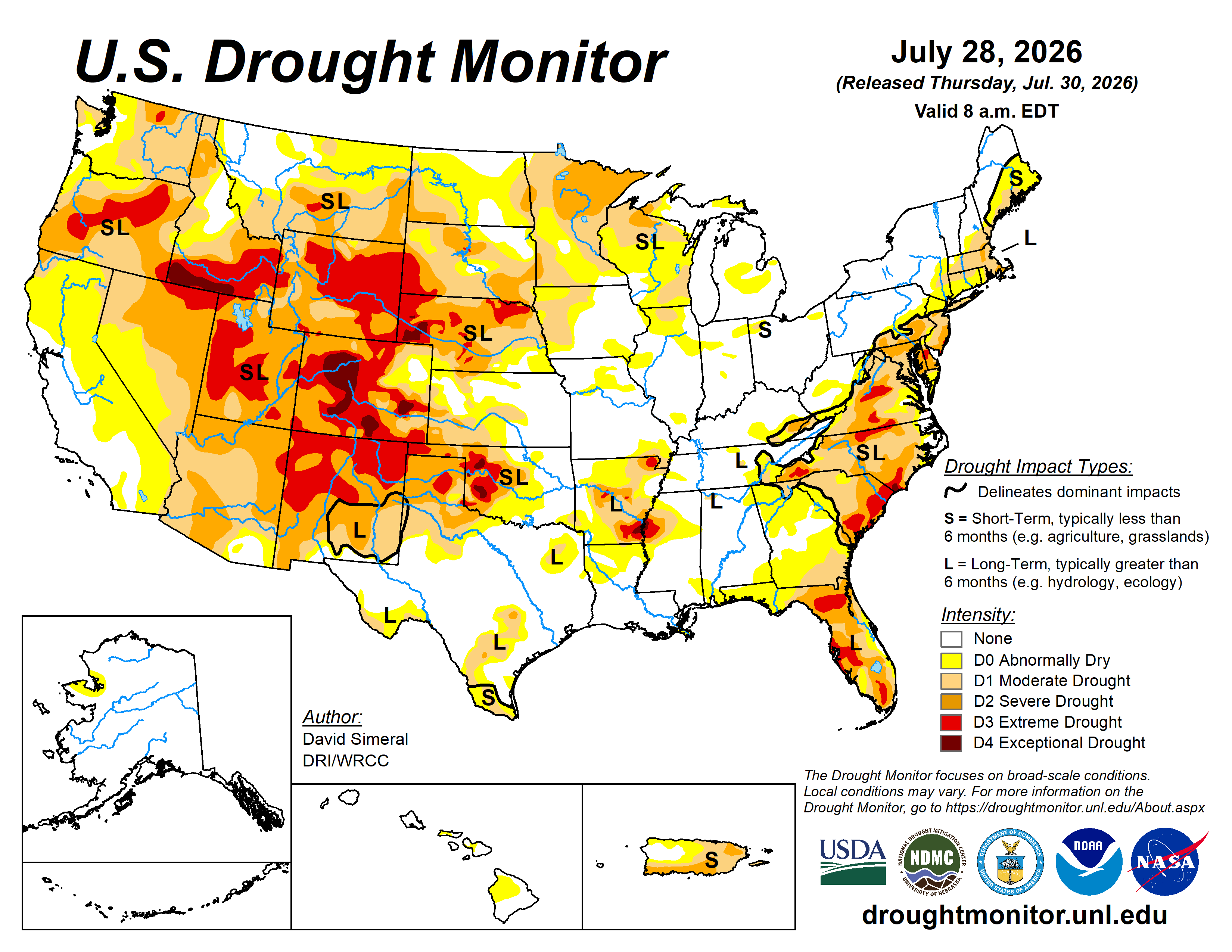
This Week’s Drought Summary
This U.S. Drought Monitor (USDM) week saw very hot and dry conditions across areas of the Western U.S. and the Plains states where average temperatures soared well above normal levels—significantly elevating evaporate demand, especially across the Upper Midwest, Northern Plains, Colorado, and the Texas Panhandle where conditions deteriorated rapidly. Elsewhere, heavy rains across areas of the Mid-Atlantic states, Southeast, and the South, led to widespread improvements on the map in drought-affected areas. In North Carolina, rainfall totals for the week ranged from 3 to 8+ inches across the state leading to a significant improvement in drought-related conditions statewide. In the Northeast, recent isolated shower activity helped to improve drought conditions; however, the impacts of the longer-term drought continue to affect groundwater conditions in areas of Rhode Island and Massachusetts. In the Upper Midwest, drought expanded and intensified on the map, especially across Minnesota and Wisconsin where composite flash drought indicators were showing severe to extreme flash drought conditions during the past week. Out West, the Four Corners states continued to receive beneficial monsoonal rainfall with isolated areas receiving 2 to 4 inches. In portions of Arizona and western New Mexico, precipitation during the past 30-day period has been above normal, boosting streamflow and soil moisture levels while improving vegetation health. In the Pacific Northwest, short-term dryness has led to a dip in soil moisture and streamflow levels in areas of western Oregon and Washington. In the Great Basin, recent monsoonal rains have provided some minor relief to drought-affected areas of eastern Nevada.
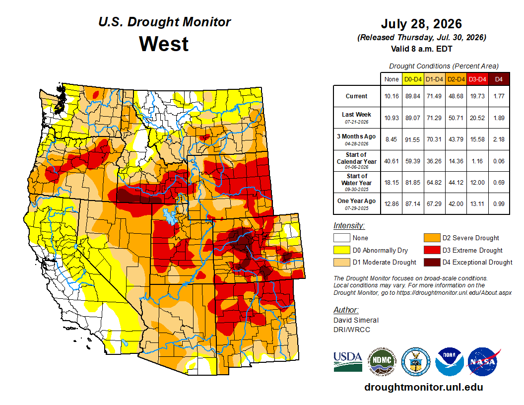
In terms of reservoir storage in the West, California’s reservoirs continue to be at or above historical averages for the date (July 28), with the state’s two largest reservoirs, Lake Shasta and Lake Oroville seeing slight decreases over the past week, at 99% and 108% of average, respectively. In the Southwest, the U.S. Bureau of Reclamation is reporting (July 26) Lake Powell at 23% full (33% of average for the date; lowest on record for the date in the last 30 years), Lake Mead at 27% full (45% of average for the date; lowest on record for the date in the last 30 years), and the total Colorado River system (July 26) at 33% of capacity (compared to 39% of capacity the same time last year). [ed. emphasis mine] According to the Salt River Project, the Salt River reservoir system in Arizona is currently 48% full, Verde River system 59% full, and the total reservoir system at 50% full (compared with 59% full a year ago)…
High Plains
For the week, drought-related conditions deteriorated across the region including in the Dakotas, Nebraska, and Kansas where temperatures were well above normal, especially in western portions of the region where anomalies ranged from 3 to 9 °F above normal. NDMC’s flash drought composite map (July 27) also showed flash drought conditions developing with numerous drought impact reports coming into the NDMC’s Condition Monitoring Observer Report (CMOR) reporting system during the past 7-day period—especially in the Dakotas in relation to crop and rangeland conditions. Looking at climatological rankings for the past 30-day period, numerous locations ranked among their warmest or near warmest mean temperatures on record, including: Rapid City NWS Weather Forecast Office, SD (warmest on record; +8 °F departure); Custer, SD (3rd warmest; +6 °F departure); Bismarck, ND (5th warmest; +5 °F departure); and Fargo, ND (3rd warmest; +5 °F departure)…

West
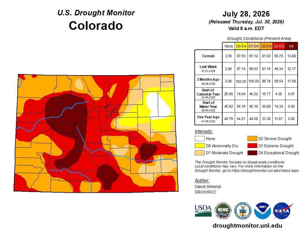
On the map, drought-related conditions deteriorated in areas of eastern Colorado, eastern New Mexico, southeastern California, and western Washington. Conversely, beneficial monsoonal rainfall led to improvements across Arizona, northwestern New Mexico, southeastern Utah, and northeastern Nevada. In the Southwest, an active monsoonal pattern (June 15 to present) has led to above-normal precipitation, especially in Arizona where percentages of normal have ranged from 150% to 250% above normal across southeastern, central, and northern portions of the state. According to the NWS Forecast Office in Tucson, AZ monsoon statistics, the following Arizona locations have received above-normal rainfall for the monsoon season: Nogales, Sierra Vista, Wilcox, Ajo, Globe, Apache Junction, Flagstaff, Kingman, Page, Prescott, Show Low, and Winslow. In Colorado, drought expanded and intensified on the map in response to anomalously warm temperatures, decreased soil moisture levels, and elevated evaporative demand. Looking at climatological rankings for the past 30-day period, numerous locations ranked among their warmest or near warmest mean temperatures on record, including: Montrose, CO (warmest on record; +3 °F departure); Dinosaur, CO (warmest on record; +4 °F departure); Grand Junction, CO (2nd warmest; +4 °F departure); Trinidad, CO (2nd warmest; +4 °F departure); Denver, CO (2nd warmest; +3 °F departure); Rock Springs, WY (3rd warmest; +4 °F departure); Casper, WY (3rd warmest; +5 °F departure); Salt Lake City, UT (5th warmest; +4 °F departure); and Pocatello, ID (5th warmest; +4 °F departure)…
South
On this week’s map, widespread improvements were made in drought-affected areas of Tennessee where rainfall has been well above normal during the past 30-to-60-day period across much of the state. In southern Texas, areas of drought expanded where hot and dry conditions have prevailed during the past 30 days. In the Texas Panhandle, short and longer-term dryness led to intensification of drought with year-to-date precipitation deficits ranging from 3 to 8+ inches. Looking at the reservoir situation, Water Data for Texas (July 29) reports statewide reservoirs at 78% full, with eastern reservoirs in good condition while numerous western, northern (Panhandle), and southern reservoirs remain below normal. Looking at climatological rankings for the past 30-days, record to near-record mean temperatures were observed in areas of the region, including in Brownville, TX (2nd warmest on record; +2 °F departure), Amarillo, TX (8th warmest; +3 °F departure), Gulfport, MS (4th warmest; +2 °F departure) and Jackson, MS (5th warmest; +2 °F departure). Average temperatures for the week were above normal across most of the region (1 to 10+ °F) with the greatest anomalies observed in the panhandles of Oklahoma and Texas…
Looking Ahead
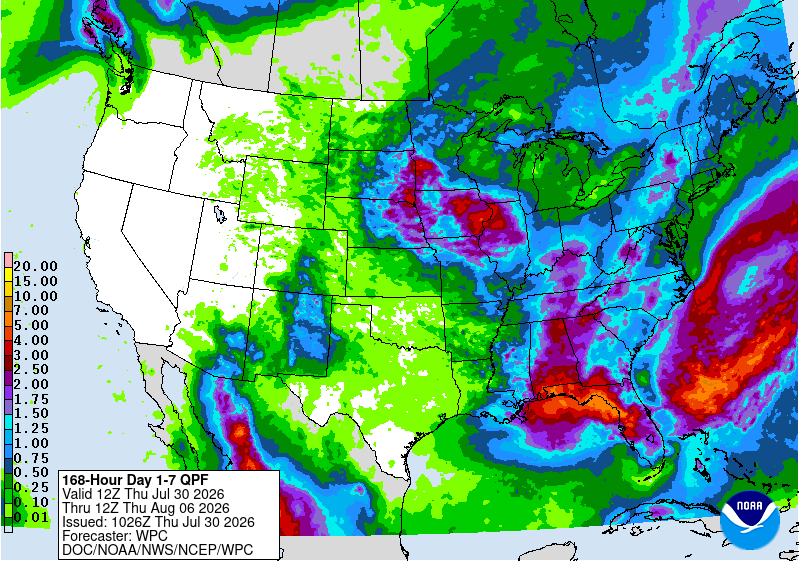
The NWS Weather Prediction Center’s 5-Day Quantitative Precipitation Forecast calls for the heavy precipitation accumulations across portions of the Gulf Coast from southeastern Louisiana to west-central Florida, where totals ranging from 3 to 5+ inches are expected. In other areas of the Southeast and Mid-Atlantic, lighter accumulations, generally ranging from 1 to 2+ inches, are expected. In the Northeast, Midwest, and eastern portions of the High Plains, precipitation accumulations generally ranging from 1 to 4+ inches are expected. In the Four Corners states, isolated monsoonal rainfall with accumulations ranging from 1 to 2 inches are forecast, while dry conditions are expected across most of the Intermountain West, Great Basin, and West Coast states.
The NWS 6-10-Day Temperature Outlook, valid August 3-7, 2026, favors above-normal temperatures across most of the contiguous United States, with the highest probabilities centered across California, the Great Basin, Desert Southwest, and portions of the central and southern Rockies. Above-normal temperatures are also favored across the Plains, Midwest, South, Southeast, and the Northeast. Near-normal temperatures are favored across portions of the Pacific Northwest and central Gulf Coast. Across Alaska, above-normal temperatures are favored, while near-normal temperatures are forecast for Southwest Alaska and the Aleutian Islands. Above-normal temperatures are favored across Hawaii.
The NWS 6-10-Day Precipitation Outlook favors above-normal precipitation across portions of the Southwest, western and southern Texas, southern Florida, Upper Midwest, and the Northeast. Below-normal precipitation is favored across portions of the Pacific Northwest, northern Rockies, northern Great Basin, and western portions of the Plains states. Elsewhere, near-normal conditions are expected. In the Hawaiian Islands, above-normal precipitation is favored.
