Click the link to read the article on The Land Desk website (Jonathan P. Thompson):
July 31, 2026
The Land Desk is evolving! During the five and a half years that I’ve been doing this, several readers and would-be-donors have urged me to make this little enterprise a non-profit. I often would respond with something like, Yeah, I’m already there. To which they’d say: No, become a 501(c)3 so that our donations can be tax deductible, dummy!
And so, finally, my wife Wendy and I bit the bullet, hired an accountant, and went through the red tape to get it done. And so, the IRS made it official earlier this month: The Land Desk Media is officially a 501(c)3. Don’t worry, we’re not going to be begging you for money every few months, or holding fund-drives, or whatever. The model will stay pretty much the same; this simply allows folks who have been so generously supporting the Land Desk as Founding/Sustaining Members, Buy Me Coffee donors, or tip Jar tippers to write off those donations.
We’ll still have free subscriptions and paid subscriptions, with the same benefits for both (the $60/year and $6/month subscription fees do not count as tax deductible donations, but if you sign up as a Sustaining Member for $200/year, for example, $140 of it would be deductible). We may occasionally look to raise money for specific initiatives: to hire a freelancer, to offset travel costs for a reporting trip, to buy a new camera lens or whatnot, to expand the scope of the Land Desk’s coverage, or to publish a book or two under our imprint, Lost Souls Press.
We’re still lining up our ducks with some of the details, but if you’d like to donate, you can do it here: Make a tax deductible donation
The Land Desk News Feed
As long as we’re talking shop, the Land Desk is about to go through a different sort of evolution, this time by adding an appendage, if you will: a human-curated rundown of the week’s biggest news from the Land Desk realm, which would include public lands, energy development, wildlife, economics, water, climate, water, and more. It would be a list of a dozen or so summaries of the news items, along with a link to the original story or stories.
This will be a once-a-week dispatch (in addition to the two each week that I send out now). The idea is to allow readers to stay in the loop without some big commitment to read a bunch of context, and for me to update folks on developments in ongoing stories in a concise way while also amplifying other voices and journalism from around the region.
I do this sort of thing three times a week for Canary Media in which I gather and summarize Western energy stories. Here’s an outtake from a recent edition:

But the Canary gig is coming to an end, which is giving me the push I needed to implement this sort of thing (although with a much broader subject range) here at the Land Desk.
I think a lot of readers will value this service, but at the same time, I don’t want to overwhelm your email boxes with too many dispatches every week. So I’m hoping y’all can let me know whether I should add this as a third weekly email for all paid and free subscribers? Or should I make it a separate newsletter altogether that would require signing up separately? (Click through to the article to participate in Jonathan’s poll.)
⛈️ Wacky Weather Watch⚡️
When I was a kid, my family occasionally took trips to Phoenix, usually to visit my grandparents who wintered in a single-wide in Apache Junction due to my grandfather’s emphysema. I loved everything about these journeys: peering out the car window as we floated through the Navajo Nation, dropping from one season into another as we descended the Mogollan Rim, competing with my brother to spot the first saguaro, and ending up in a place where palm trees lined streets and citrus orchards surrounded the city.
In my teens and twenties my fondness for the Sonoran Desert migrated southward to Tucson. I was drawn by the vibrance of both the city and surrounding desert, as well as the climate; in the springtime I could begin a hike up Mt. Wrightson in t-shirt and shorts, strolling below the lush canopy amid birdsong, and end up huddling under a rock in a blizzard at the top. Then I could reward myself with some killer tacos in South Tucson on the way back. I always figured I’d live down there someday.
I’m still fond of Tucson and, yes, even Phoenix. But the idea of living in the place, especially the latter, gets less and less palatable with every passing year as temperatures rise. Check out this weekend’s forecast, which, believe it or not, is actually milder than the high temps from last weekend:

The 115° F daytime high is brutal — especially for those with homes that don’t have AC or decent insulation or who don’t have houses, at all. That’s the kind of heat that kills, as the statistics make all too clear. But it’s the 93° F nighttime low that really frightens me: The city is still an oven during the coolest, darkest hours of pre-dawn. Even if you do have a climate-controlled home and good AC in your car, you’re virtually trapped inside. A 5 a.m. run in those temperatures would be unhealthy, maybe even deadly.
But don’t think you can escape by heading to Colorado or Utah. Grand Junction and Hotchkiss are sweltering through triple digit highs as well; Moab’s mercury may hit 110° F this weekend, with 112° F forecasted for St. George. The timing’s especially bad for farmers in the North Fork Valley, where one of the major irrigation canals is shutting down today (July 31) due to lack of water in the reservoir (at least one of the other big ditches in the area shut down on July 20).
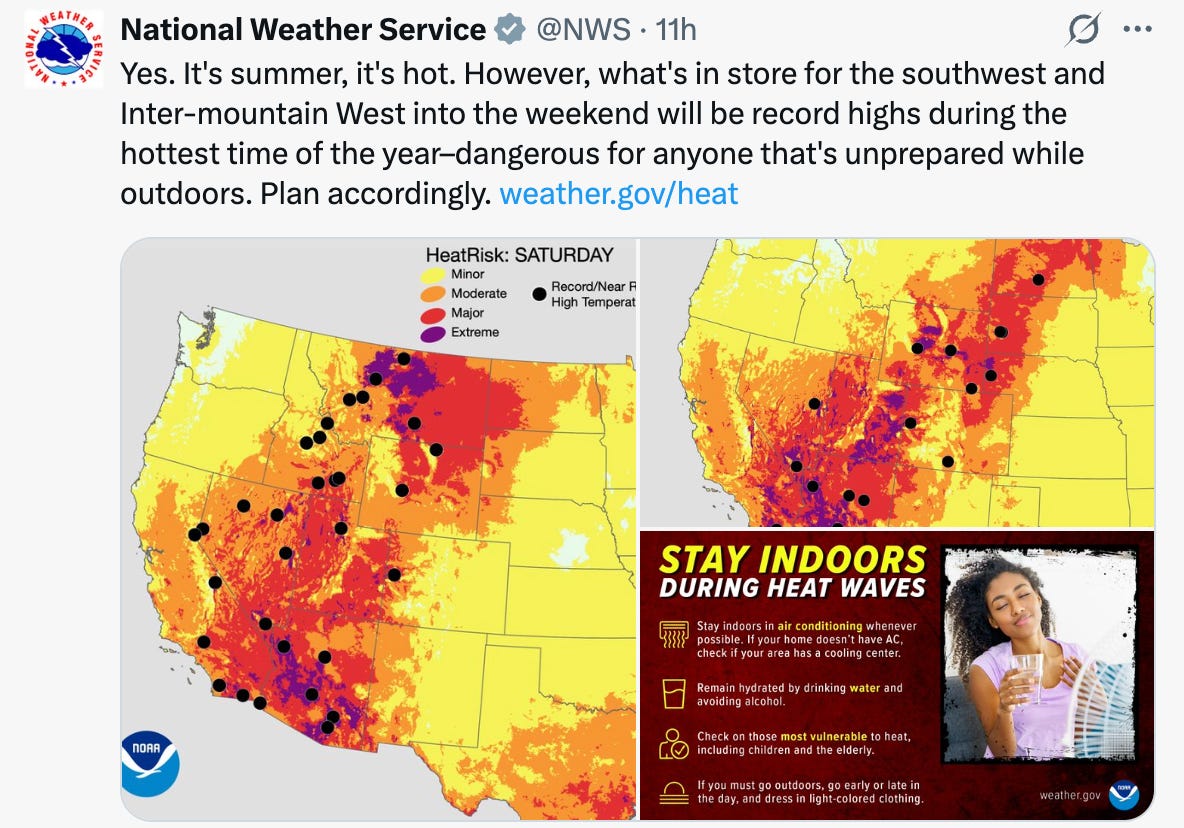
The current heatwave comes on the heels of an extreme heat spell that shattered all-time maximum heat records at 88 weather stations across the West, e.g.: 114° F in Brandenberg, Mont.; 104° F in Swan Valley, Idaho; 104° F at Pineview Dam, Utah; 109° F in Thermopolis, Wyo.; and 113° F in Burlington, Colo.
Those extraordinarily warm temperatures joined up with lightning to spark fires across the region, especially in the Northwest, which continues to burn. Oregon’s Lowe Creek Complex has ballooned to 300,000+ acres, and several other fires in the region exceed 50,000 acres in size. The smoke is traveling across the country and is even dimming air quality on the East Coast. More fire weather (dry, hot, windy) is forecasted for this weekend.
And if the heat doesn’t get you, the flash floods could. The intense yet isolated thunderstorms continue to wreak mayhem. Two massive debris flows hit Hwy 550 between Ouray and Silverton on Wednesday, trapping motorists and shutting down the artery — it remained closed Thursday night. Flooding also occurred on the Gold Mountain Fire scar north of Ouray. On Wednesday, the normally tame Cutler Creek became a raging, chocolate-colored, fire-debris-filled torrent that escaped its banks and blasted into homes, causing one family to fear for their lives.

In the winter, Colorado staffs mountain highways with avalanche forecasters to monitor conditions and recommend shutting down the roads during high danger. With all of the landslide/debris flow action affecting highways and backroads, perhaps it’s time to make the program year round?
Thankfully, the rains have helped stifle the erratic behavior of the big blazes in Colorado and Utah, though a new fire, the Rio Blanco blaze, is burning south of Pagosa Springs, and had reached 730 acres as of Thursday night.
🗺️ Messing with Maps 🧭 🥵 Aridification Watch 🐫
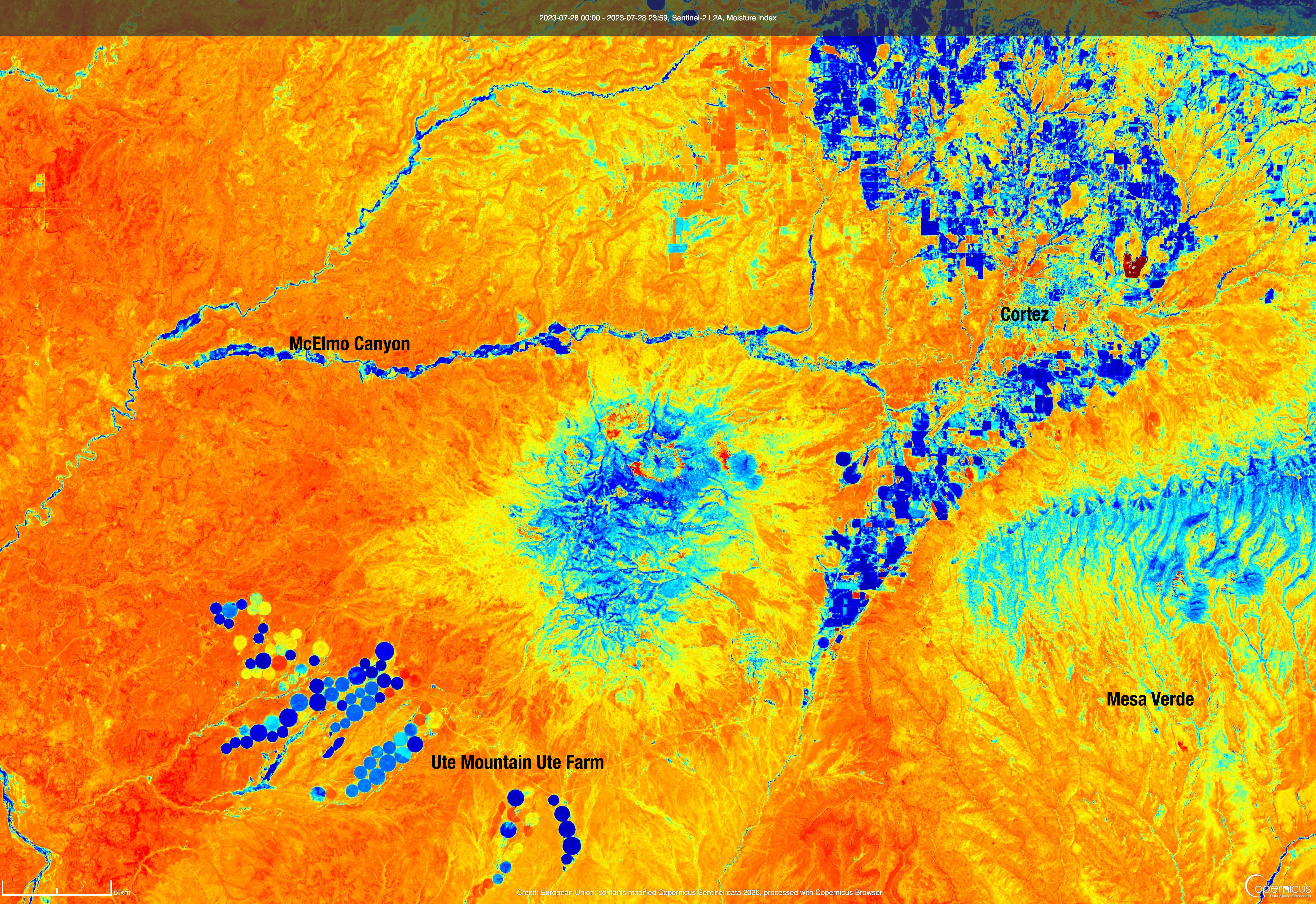
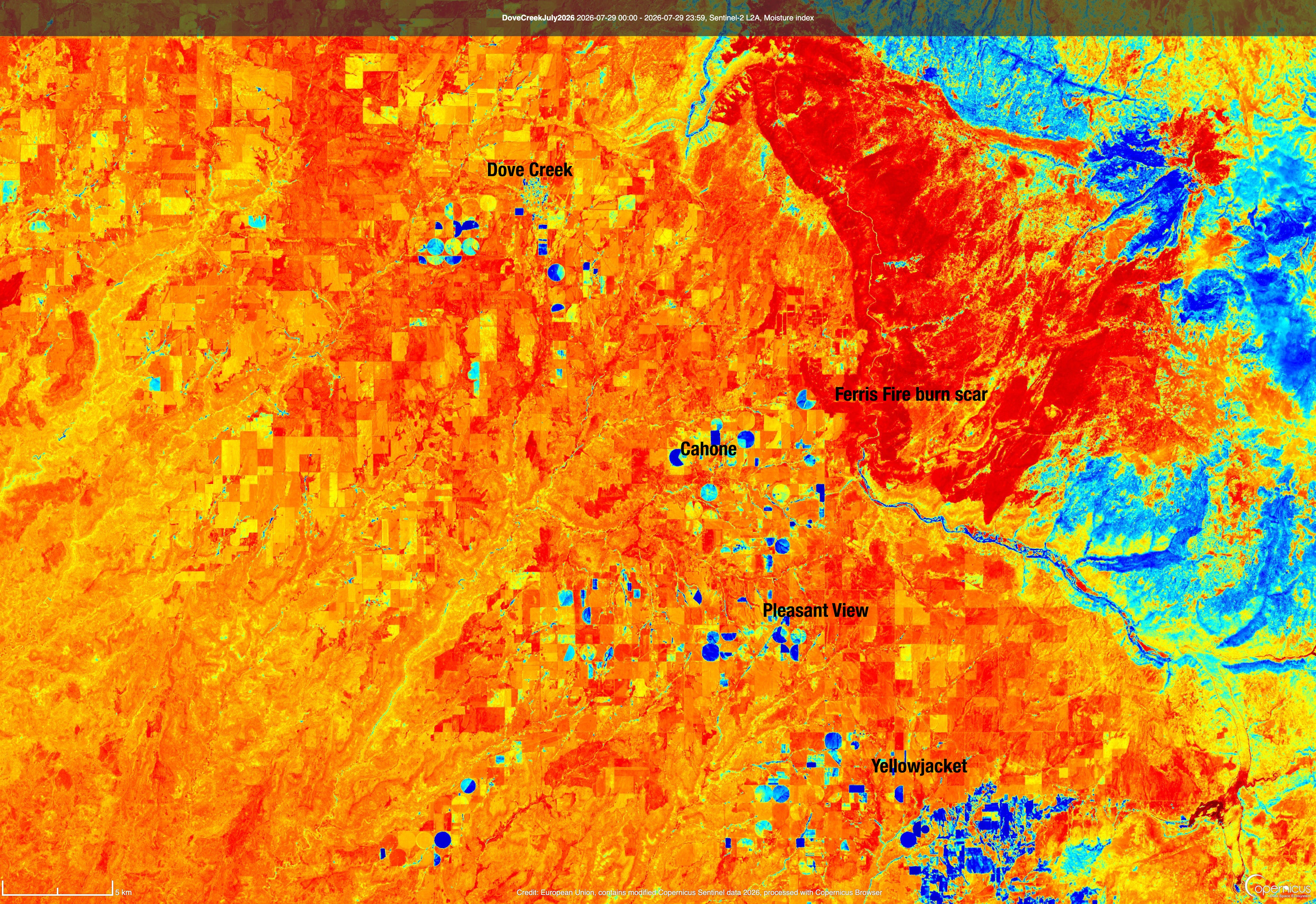
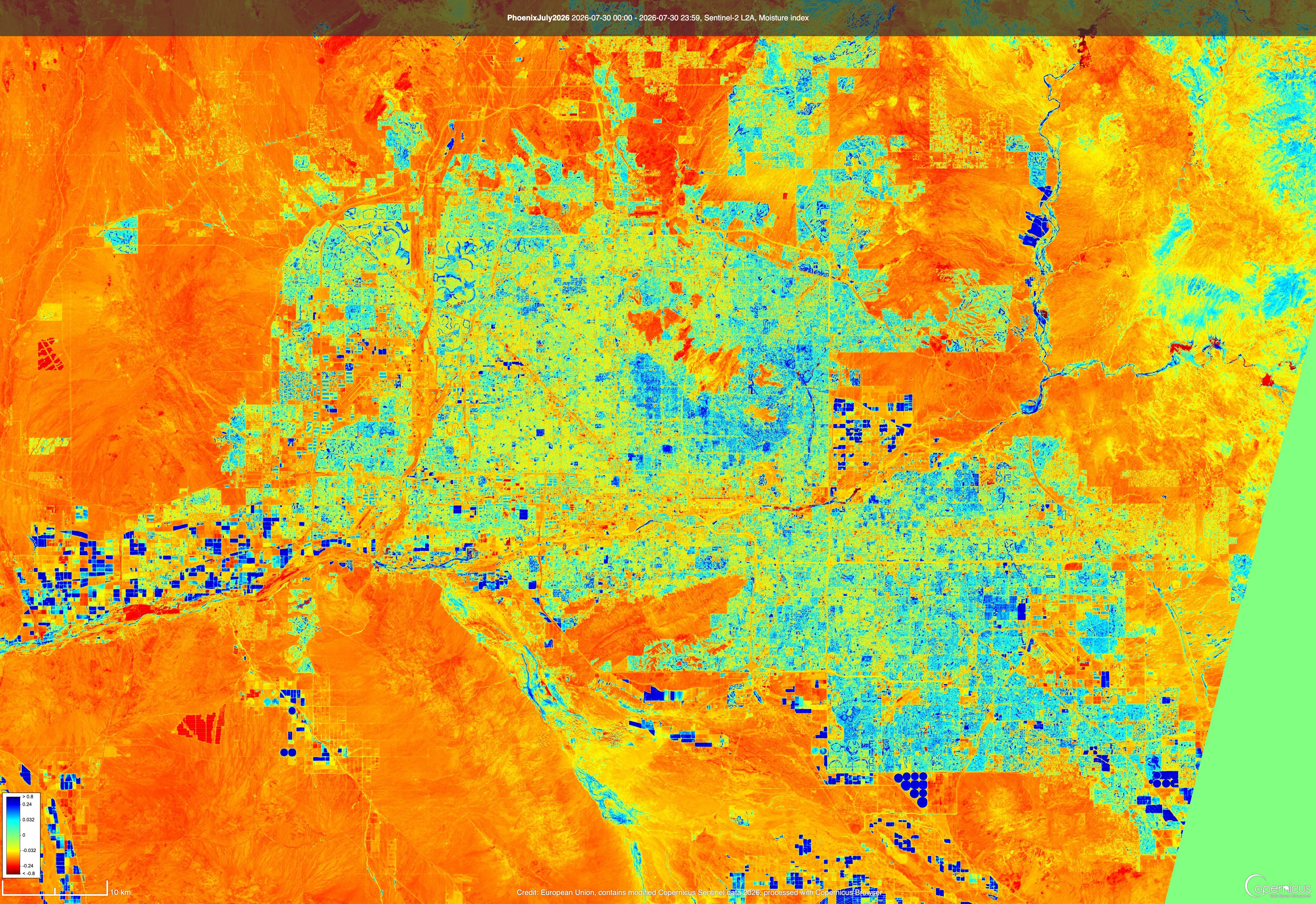
The satellite images below, using the Moisture Index layer on the Copernicus Browser, contrasts dry areas (yellow, orange, and red) with more moist areas (green, blue, and dark blue). Each of the maps accentuates the importance of irrigation to the West’s agriculture and, really, to its communities, by showing a stark line between irrigated areas and non-irrigated ones.
Comparing the maps to one another shows how much drier the region is this year than it was three years ago, following one of the wetter winters of recent history. It also provides a visual illustration of the way the prior appropriation doctrine — which rules Western water law — plays out on the ground during dry years between the haves (those with senior water rights) and the have nots (those with junior water rights).
In this case it also shows how unjust and unfair the doctrine can be. The Ute Mountain Ute Tribe has 1868 rights to water from the Dolores River, making them the most senior rights holders of all (as one would expect). However, their water is delivered to them via the Dolores Project, whose water rights are tied to the date of congressional approval, or 1968.