Global Warming Surges Well Past 1.5-Degree Mark in 2024: International agencies coordinate release of annual climate data to highlight the past yearโ€™s โ€œexceptionalโ€โ€”and dangerousโ€”climate conditions — Bob Berwyn (Inside #Climate News)

Sunset September 10, 2024 in the San Luis Valley. Photo credit: Alamosa Citizen

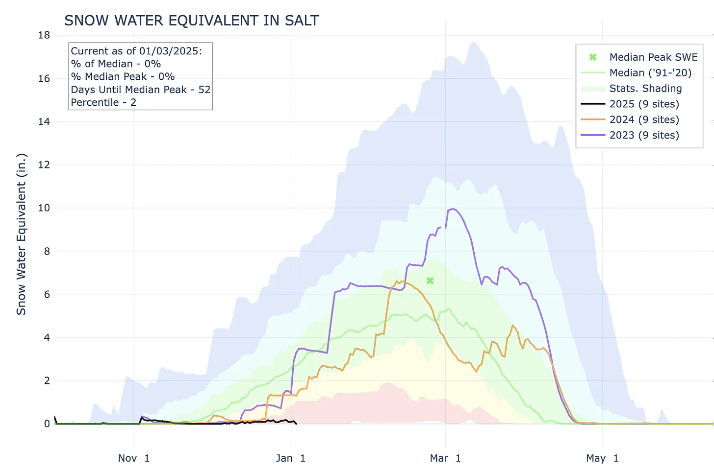
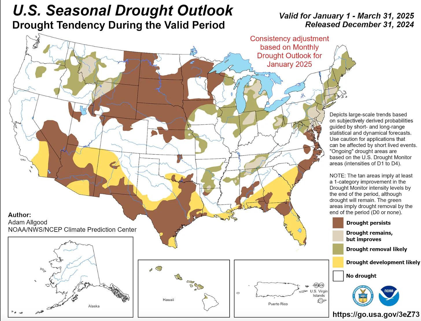
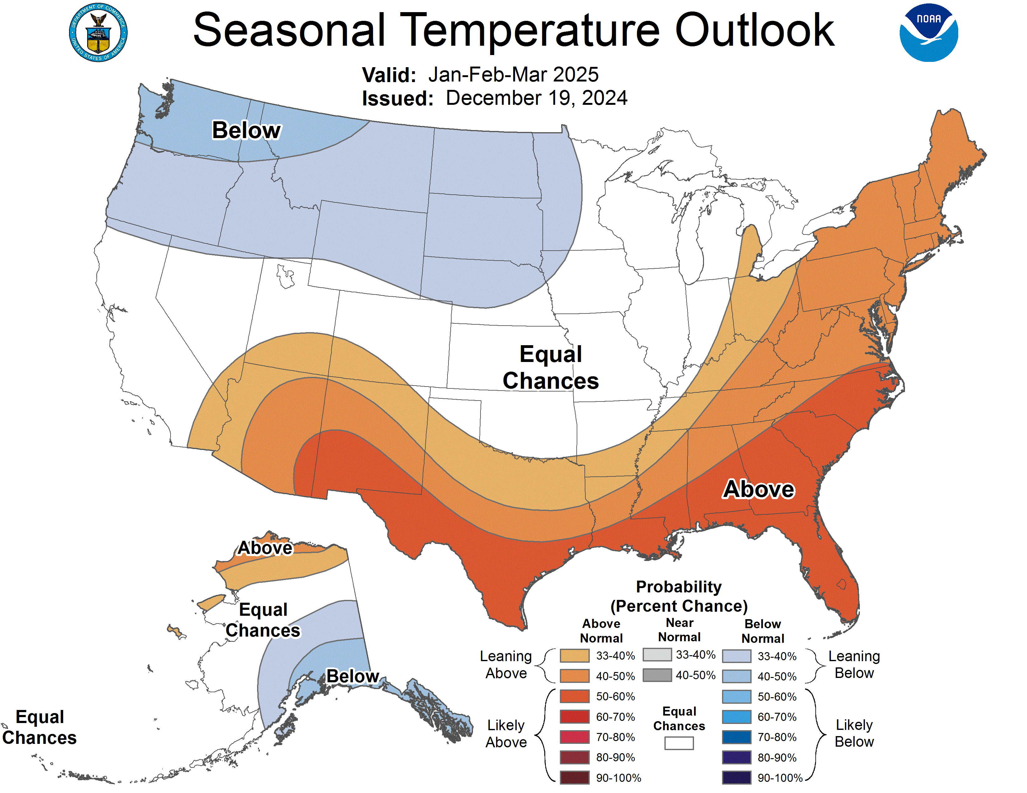
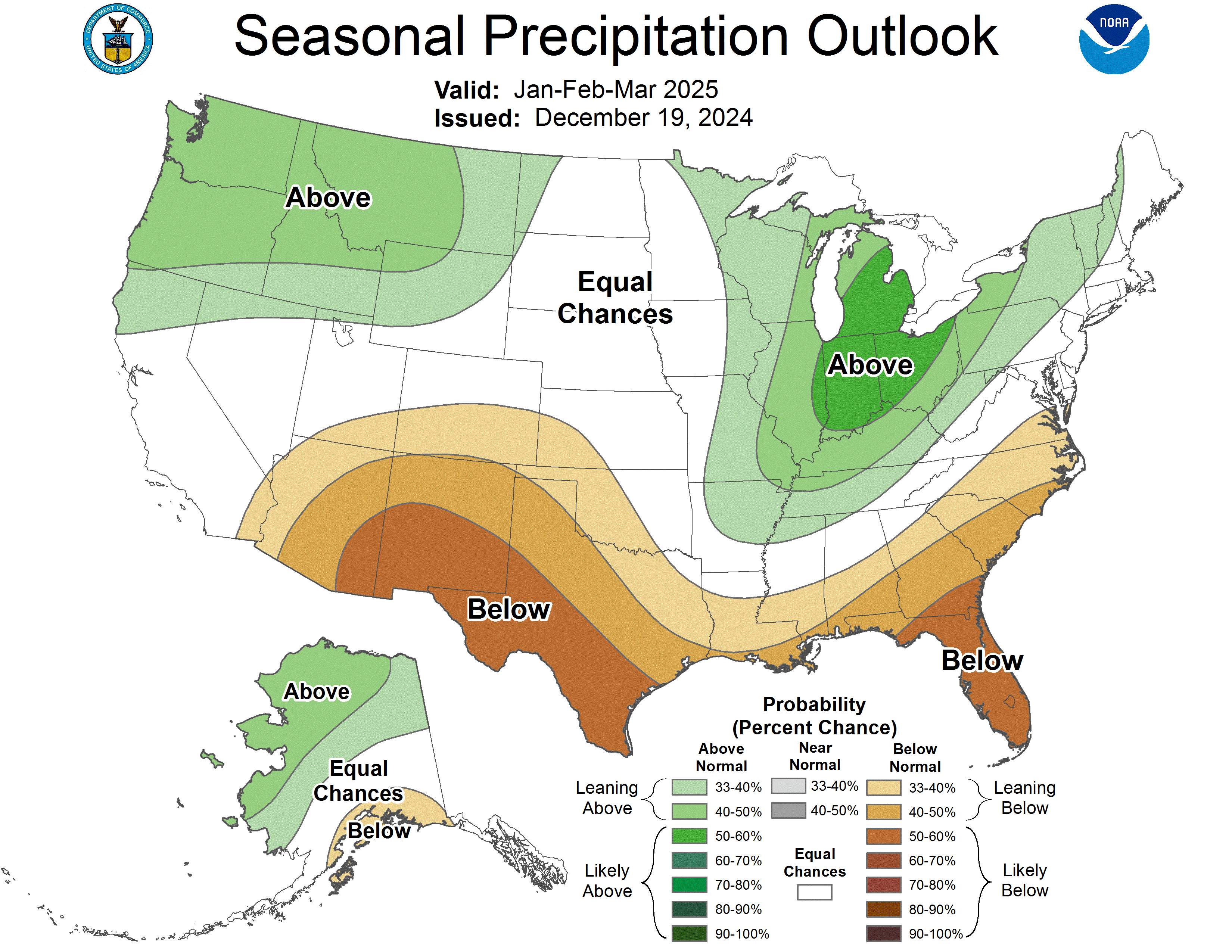
Click the link to read the article on the Inside Climate News website (Bob Berwyn):

January 9, 2024

Nearly all major global climate datasets agree that, in 2024, human-caused global warming for the first time pushed Earthโ€™s average surface temperature to more than 1.5 degrees Celsius above the pre-industrial average for a full calendar year, a level that countries around the world had agreed to do all they could to avoid.

And when last year is averaged with 2023, both years together also exceed that level of warming, which was noted as a red line marking dangerous climate change by 196 countries in the 2015 Paris Agreement. A 2018 special report by the Intergovernmental Panel on Climate Change showed that warming beyond that limit threatens to irreversibly change major parts of the physical and biological systems that sustain life on Earth, including forests, coral reefs and rainforests, as well as oceans and their major currents.

The temperature figures were seen as so significant that the new annual climate data for 2024 was presented Thursday night as part of the first-ever internationally coordinated release by several institutions that track global temperatures, in part to mark the โ€œexceptional conditions experienced in 2024,โ€ according to a report published today by Copernicus, the European Unionโ€™s climate change service. 

On Friday, the National Oceanic and Atmospheric Administration, NASA and the World Meteorological Organization will follow up with similar reports, all of which will emphasize not only the record global temperatures, but also the record amount of water vapor in the atmosphere that contributed to severe and record flooding in some parts of the world last year, and also helped supercharge tropical cyclones and hurricanes.

Rather than being fatigued by the barrage of news about heat records and other climate extremes, people should see the information as an opportunity to be thankful that we are not flying blind into dangerous climate change, said Carlo Buontempo, director of the Copernicus Climate Change Service

Thanks to international science, โ€œWe do know something about whatโ€™s happening,โ€ he said. โ€œWe can make some predictions about whatโ€™s coming in the future. So rather than being overwhelmed โ€ฆ we should also take this as an opportunity to do something about it, to react to and to inform our decisions in the best possible way with facts and evidence.โ€

Even with those facts, he added, โ€œWe are facing a very new climate and new challenges that our society is not prepared for. โ€ฆ This is a monumental challenge for society.โ€

According to the Copernicus data, 2024 didnโ€™t just edge past the previous record-warm year, 2023, but surged more than a tenth of 1 degree Celsius all the way to 1.6 degrees Celsius (2.8F) above the pre-industrial level. That was one of the biggest year-on-year jumps on record, said Samantha Burgess, co-director of Copernicus. 

She said some of the other global datasets may actually still show the 2024 warming relative to the pre-industrial 1850-1900 average at just below 1.5 degrees Celsius (2.7F), but that the global synthesis of six major datasets by the World Meteorological Organization will also come out to more than 1.5.

Still, she said, that doesnโ€™t mean the limit set by the Paris Agreement has been broken, because it refers to a long-term average over 10 to 30 years. 

If the 1.6 degrees Celsius of warming over the pre-industrial average doesnโ€™t seem like a huge deal to some people, she said human bodies provide a good analogy.

โ€œThe temperature of the human body is around 37 [degrees Celsius],โ€ she said. โ€œIf we have a fever at 39 degrees, it doesnโ€™t sound like much, but the body responds in very negative ways, and we feel terrible. Weโ€™re feverish, and the body is doing everything possible to fight that infection.

โ€œThe reality is that at a global average change of 1.5 degrees, the frequency and the intensity of extreme events gets more likely,โ€ she said. โ€œExtreme events like wildfires, heat waves, severe storms, droughts, are likely to get more frequent, and theyโ€™re likely to be more intense. This is why, when youโ€™ve got this small number but over a very large global average, itโ€™s incredibly important.โ€

The Copernicus scientists said that the worldโ€™s oceans, in particular, were one of the biggest factors driving Earthโ€™s overall annual temperature to a new record. That ocean warmth also had direct impacts like a global wave of coral bleaching and reef die-offs, as well as mass die-offs of marine mammals and seabirds

On land, the persistently high global fever of the last few years led to deadly heat waves, with more than 47,000 heat-related deaths in Europe alone during 2023. Final figures for the number of such deaths in 2024 are yet to be calculated.

The new data on record warmth comes at a time when some governments and companies are already rolling back previous climate action pledges. The internationally coordinated release of global climate data could also be seen as an acknowledgment that global warming isnโ€™t going to slow down and wait for humanity to solve other vexing social, political and economic problems.

Asked if those rollbacks in the face of record heat are worrying to him as a climate scientist, Buontempo said that, โ€œFrom a physical point of view, the mechanism is well explained. What drives this warming temperature is, to a very large extent, increasing greenhouse gases.โ€

If the goal is to stabilize the global temperature, then governments need to move toward reducing emissions to zero โ€œin the most rapid possible way,โ€ he said.

What will the future of the warming stripes be?2024 could be the start of a stabilisation of global temperatures, or it might appear to be a cool year.Which one of these stories becomes reality depends on our choices today, and every day until then.We are likely to regret not acting sooner.

Ed Hawkins (@edhawkins.org) 2025-01-10T11:13:06.384Z

January 2025 update: La Niรฑa is here — NOAA #ENSO

Click the link to read the article on the NOAA website (Emily Becker):

January 9, 2025

La Niรฑa conditions emergedย in the tropical Pacific in December. Thereโ€™s a 59% chance La Niรฑa will persist through Februaryโ€“April, followed by a 60% chance of neutral conditions in Marchโ€“May. Read on for the recent observations that led us to declare the (long-awaited) onset of La Niรฑa and lots of details for current and potential upcoming conditions.

Just the facts, maโ€™am

A quick briefing, if youโ€™re just joining usโ€”La Niรฑa is one phase of the El Niรฑo/Southern Oscillation (ENSO), a pattern of sea surface temperature and atmospheric changes in the tropical Pacific Ocean. La Niรฑaโ€™s signature is cooler-than-average surface water in the east-central Equatorial Pacific, while its counterpart, El Niรฑo, features warmer-than-average surface water. The atmospheric circulation over the tropical Pacific, called the Walker circulation, exhibits characteristic changes during La Niรฑa and El Niรฑo, so we call ENSO a โ€œcoupledโ€ ocean-atmosphere system. ENSO is a seasonal phenomenon, meaning it lasts for several months in a row. The atmospheric changes of ENSO are communicated all around the world, changing temperature and rain/snow patterns in known ways.

Time to get down to brass tacks

Ok! Weโ€™ve been expecting La Niรฑa to show up since last spring. While sheโ€™s dragged her heels, all the pieces came together this past month.

The tropical Pacific sea surface temperature loitered in ENSO-neutral since April 2024, with our primary ENSO monitoring index, the Niรฑo-3.4 index, within 0.5 ยฐC of the long-term average. In December, however, the Niรฑo-3.4 index was -0.6 ยฐC, according to the ERSSTv5, our most reliable long-term sea surface temperature dataset.

2-year history of sea surface temperatures in the Niรฑo-3.4 region of the tropical Pacific for all La Nina events since 1950 (gray lines) and the recent (2024-25) event (purple line). After staying in neutral for most of 2024, the Niรฑo-3.4 index passed the La Niรฑa threshold in December 2024. Graph by Emily Becker based on monthly Niรฑo-3.4 index data from CPC using ERSSTv5.

With the Niรฑo-3.4 Index exceeding the La Niรฑa threshold of -0.5 ยฐC, we can move on to the second box on our flowchartโ€”do we think the Niรฑo-3.4 index is going to stay in La Niรฑa territory for the next several seasons? (โ€œSeasonsโ€ here means any 3-month-average period.) The consensus among our computer climate models is yes. Also, there is a substantial amount of cooler-than-average water under the surface of the tropical Pacific, which will provide a source for the surface over the next few months.  

So, weโ€™re on to the third box, which has actually been checked for a while now (more on that later). The atmosphere has been looking La Niรฑa-ish for months, with stronger-than-average trade winds, more clouds and rain over Indonesia, and drier conditions over the central Pacificโ€”all hallmarks of an amped-up Walker circulation. In December, the Equatorial Southern Oscillation Index (EQSOI), which measures the difference in surface pressure between the western and eastern Pacific, was 1.5 (positive values indicate a stronger Walker circulation). In fact, this is the 5th-strongest December EQSOI in the historical record. Drumrollโ€ฆ La Niรฑa conditions have developed.

This animation shows weekly sea surface temperatures in the Pacific Ocean compared to average from October 14 2024โ€“January 5 2025. Orange and red areas were warmer than average; blue areas were cooler than average. The sea surface temperature in the key ENSO-monitoring region of the tropical Pacific (outlined with black box) was slightly below average for many weeks, but the cooler-than-average region has strengthened lately. NOAA Climate.gov animation, based on Coral Reef Watch Data and maps from NOAA View. View the full-size version in its own browser window.

Break it down for me

There are a lot of different tidbits I want to tell you about this month, so letโ€™s go Q&A-style.

How long will La Niรฑa last?

Thereโ€™s a reason our flowchart says โ€œthe next several seasonsโ€ instead of providing a specific number: we can make predictions, but itโ€™s impossible to know ahead of time exactly how long La Niรฑa conditions will last. To be categorized as a La Niรฑa event in our historical record, the three-month-average Niรฑo-3.4 Index (the Oceanic Niรฑo Index) needs to stay at least 0.5 ยฐC below average for at least five consecutive, overlapping seasons. Current odds are 60% that the Marchโ€“May Oceanic Niรฑo Index will be neutral, which would make this event last fewer than five. Thatโ€™s not to say itโ€™s impossible for this La Niรฑa to last longer, of courseโ€”nature is always full of surprises!  There is a ~40% chance for La Niรฑa to persist into March-May 2025.

How strong will La Niรฑa be?

Itโ€™s very likely this La Niรฑa will be weak, with the Niรฑo-3.4 index unlikely to reach -1.0 ยฐC for a season. This is based on computer model guidance and how late in the year La Niรฑa conditions emerged. ENSO events peak in the northern Hemisphere winter, and thereโ€™s just not a lot of time for La Niรฑa to strengthen.

Can La Niรฑa still affect our winter climate?

Sure can, although a weak La Niรฑa tends to have a weaker influence over temperature and precipitation patterns.

Why was La Niรฑa so slow to develop?

The short answer to this is โ€œwe donโ€™t yet know.โ€ The emergence of La Niรฑa-like atmospheric conditions before substantial tropical Pacific Ocean surface cooling was unusual, though. The global oceans have been running much, much warmer than average for more than a year, which might have had a hand in La Niรฑaโ€™s delay. When we calculate the Niรฑo-3.4 index but account for the temperature of the tropical oceans (the โ€œRelative Niรฑo-3.4 indexโ€) we get an index thatโ€™s been in La Niรฑa territory for months. Only this past year or so has the difference between the traditional and relative Niรฑo-3.4 indexes been so large, and weโ€™re still researching this new measurement and all the implications for ENSO development and impacts in a warmer world.

Has La Niรฑa had any impact on temperature and rain patterns yet?

La Niรฑa affects global climate primarily through atmospheric changes, and since the tropical atmosphere has been looking like La Niรฑa for a while, this is a reasonable question! The global climate is incredibly complicated, and even a big factor like ENSO is only one player. Other climate patternsclimate change trends, and random variability can have a strong influence on overall seasonal patterns. That said, itโ€™s interesting that the Octoberโ€“December 2024 temperature and rain/snow patterns over the U.S. resemble the expected patterns from previous La Niรฑa events. See the Octoberโ€“December La Nina temperature and rain/snow maps, and hereโ€™s the general page if you would like to poke around.

Map showing the difference from average precipitation during Octoberโ€“December 2024. Green areas received more rain and snow than the 1991โ€“2020 average, while brown areas received less. The pattern here resembles what we would expect in Octoberโ€“December during La Niรฑa. Map by climate.gov from CPC data.

Temperature has a strong influence from climate trends, and the Octoberโ€“December 2024 temperature pattern over the U.S. is clearly dominated by more warmth.

Map showing the difference from average temperature during Octoberโ€“December 2024. Orange areas were warmer than the 1991โ€“2020 average. The pattern here resembles what we would expect in Octoberโ€“December from combined climate trends and La Nina. Map by climate.gov from CPC data.

Youโ€™re running out of column inches. Any last tidbits?

Thanks for asking! Speaking of La Niรฑa impacts, you might recall thereโ€™s a link between La Niรฑa and active Atlantic hurricane seasons. In brief, La Niรฑa reduces vertical wind shearโ€”the difference between near-surface winds and upper-level windsโ€”and makes it easier for hurricanes to grow. Interestingly, the Augustโ€“October 2024 wind shear in the Atlantic Main Development Region (an area of the Atlantic where hurricanes tend to develop) was the weakest since 1950 (h/t NOAAโ€™s Matt Rosencrans). We canโ€™t say how much of it was related to La Niรฑa, but given the relative Niรฑo-3.4 index has been in La Niรฑa territory for a while now, itโ€™s an interesting situation that bears more research.

The bottom line

As this unusual La Niรฑa progresses, weโ€™ll be here to keep you updated on all things ENSO!

Here are the typical outcomes from both El Niรฑo and La Niรฑa for the US. Note each El Niรฑo and La Niรฑa can present differently, these are just the average impacts. Graphic credit: NWS Salt Lake City office

#Drought news January 9, 2025: Based on 30 to 60-day SPI along with a lack of early season snowpack, a 1-category degradation was made to southwestern #Colorado, SWE was below-normal across the Four Corners Region

Click on a thumbnail graphic to view a gallery of drought data from the US Drought Monitor website.

Click the link to go to the US Drought Monitor website. Here’s an excerpt:

This Week’s Drought Summary

On January 4 and 5, a low pressure system developed across the Central Great Plains and then tracked eastward to the Mid-Atlantic. Along its track, widespread precipitation (1 to 2 inches, liquid equivalent) was observed throughout eastern Kansas, Missouri, the Ohio and Tennessee Valleys, Central Appalachians, and Mid-Atlantic. Total snowfall amounts were near or more than a foot in portions of these areas. This winter storm also resulted in freezing rain for the Ohio Valley and parts of Virginia and West Virginia. Drought improvements were generally made to portions of the central and eastern U.S. where precipitation amounts exceeded 1 or 1.5 inches, liquid equivalent. Drought coverage and intensity continued its decline for the Upper Ohio Valley and New England. After the winter storm exited the East Coast, an arctic air outbreak overspread the eastern two-thirds of the lower 48 states. A favorable start to the wet season coupled with above-normal snowpack supported a decrease in drought coverage across the Pacific Northwest. Conversely, drought worsened for southern California and the Southwest. Alaska and Puerto Rico remained drought-free, while short-term drought intensified across Hawaii…

High Plains

Based on 30 to 60-day SPI along with a lack of early season snowpack, a 1-category degradation was made to southwestern Colorado. Farther to the north across northwestern Colorado, improving snowpack resulted in a minor reduction in abnormal dryness (D0). Southwestern Nebraska has received little to no precipitation during the past 7 weeks, prompting an expansion of D0. In addition, above-normal temperatures during the late fall and into the early winter exacerbated increasing short-term dryness. Heavy precipitation (more than 1 inch, liquid equivalent) for this time of year resulted in a 1-category improvement to northeastern Kansas. No changes were made to the Dakotas and early January is one of the driest times of the year…

Colorado Drought Monitor one week change map ending January 7, 2025.

West

A dry start to the winter and using 90-day SPI and soil moisture, moderate drought (D1) was expanded across southern California. The NDMC short-term blend, 90-day SPI, and many 28-day average streamflows below the 10th percentile supported the addition of severe drought (D2) to portions of southern California. The Santa Ana winds during early January are likely to exacerbate the worsening drought conditions. Consistent with the NDMC short-term blend along with 30 to 120-day SPI, D2 was expanded for portions of southeastern Arizona and southwestern New Mexico. Based on water year to date (WYTD: October 1, 2024 to January 6, 2025) precipitation averaging above normal and snow water equivalent (SWE) above the 80th percentile, a 1-category improvement was made to southwestern Idaho, eastern to central Oregon, eastern Washington and a small part of northwestern Montana. This 1-category improvement is also supported by NDMC drought blends and SPIs at various time scales. As of January 7, SWE was above-normal (period of record: 1991-2020) across the southern Cascades along with eastern Oregon and southwestern Idaho. SWE was highly variable for the Sierra Nevada Mountains and below-normal across the Four Corners Region…

South

Based on 30 to 120-day SPI, 28-day streamflow, and soil moisture, a 1-category degradation was made to portions of the Edwards Plateau of Texas. SPIs at various time scales and soil moisture supported a 1-category degradation as well for parts of the Rio Grande Valley. Heavy rainfall during late December supported additional improvements across southeastern Texas. Recent rainfall (1 to 2 inches) prompted a 1-category improvement to parts of Mississippi and Tennessee. Despite the recent rainfall, 28-day average streamflow and 90-day SPI support a continuation of D1-D3 intensity for the Tennessee Valley. Although precipitation was lighter this past week, the lack of any support among the indicators for D0 and D1 led to improvements to much of Arkansas…

Looking Ahead

A low pressure system is forecast to develop along the western Gulf Coast by January 10 with a rapid eastward track offshore of the Mid-Atlantic one day later. A large area of 1 to 2.5 inches of rainfall is expected for eastern Texas and the Lower Mississippi Valley, while accumulating snow occurs from the southern Plains east to the Tennessee Valley and Southern Appalachians. High elevation snow is forecast to shift east from the Cascades to the northern Rockies on January 10 and 11. Farther south across California, dry weather is likely to persist through mid-January. On January 13, another Arctic high is forecast to shift south from Canada to the Great Plains.

The Climate Prediction Centerโ€™s 6-10 day outlook (valid January 14-18, 2025) favors below-normal temperatures for a majority of the lower 48 states. The largest below-normal temperature probabilities (exceeding 80 percent) are forecast for the Southeast. An increased chance of above-normal temperatures is limited to the Dakotas and Minnesota. Below-normal precipitation is most likely across the Pacific Northwest, Great Basin, and much of California. Elevated above-normal precipitation probabilities are forecast for the Southwest, Texas, and High Plains, while below-normal precipitation is slightly favored along the East Coast.

US Drought Monitor one week change map ending January 7, 2025.

Just for grins here’s a slideshow of early January US Drought Monitor maps for the past few years.

Cleanup of abandoned uranium mines set to start after Navajo Nation, EPA reach agreement — AZCentral.com

Graphic credit: Environmental Protection Agency

Click the link to read the article on the AZCentral.com website (Arlyssa D. Becenti). Here’s an excerpt:

January 8, 2025

After years of demanding the cleanup of uranium waste at the Kerr-McGee Quivira Mines on the Navajo Nation community advocates got the news this week that the Environmental Protection Agency will remove waste rock from three areas of the site and move it to a new off-site repository. The removal of over 1 million cubic yards of radioactive waste from the sites about 20 miles northeast of Gallup will begin in early 2025, the EPA said. The waste will be taken to a new off-site repository at Red Rocks Landfill east of Thoreau, N.M. The process, including permitting, construction, operation and closure of the repository, is expected to take 6-8 years.

โ€œI feel as though our community finally has something of a win,โ€ said Teracita Keyanna, a member of the executive committee for Red Water Pond Road Community Association. โ€œRemoving the mine waste from our community will protect our health and finally put us back on a positive track to Hรณzhวซ.โ€

Commercial exploration, development, and mining of uranium at Quivira Mines began in the late 1960s by the Kerr-McGee Corporation and later its subsidiary. The mine sites are the former Church Rock 1 (CR-1) mining area; the former Church Rock 1 East (CR-1E) mining area; and the Kerr-McGee Ponds area. The mines were in operation from 1974 to the mid-1980s and had produced about 1.2 million tons of ore, making them among the 10 highest producing mines on the Navajo Nation…From World War II until 1971, the U.S. government was the sole purchaser of uranium ore, driving extensive mining operations primarily in the southwestern United States. These efforts employed many Native Americans and others in mines and mills. Between 1944 and 1986, nearly 30 million tons of uranium ore were extracted from Navajo lands under leases with the Navajo Nation. With over 500 abandoned uranium mines โ€” many say the total could be in the thousands โ€” clean up of mines has always been a battle.

Arkansas Valley Conduit awarded an additional $250 million — Chris Woodka (Southeastern #Colorado Water Conservancy District) #ArkansasRiver

Reclamation Commissioner Camille Calimlim Touton greets several members of the Southeastern District Board, from left, Bill Long, Kevin Karney, Howard โ€œBubโ€ Miller, Andy Colosimo and Justin DiSanti. Photo credit: Southeastern Colorado Water Conservancy District

January 8, 2025

Camille Calimlim Touton, Commissioner of the U.S. Bureau of Reclamation, traveled to Pueblo on Wednesday, January 8, to announce an additional $250 million for construction of the Arkansas Valley Conduit.

โ€œWe are proud to see the work underway because of President Bidenโ€™s Investing in America agenda,โ€ Commissioner Touton said. โ€œBut thereโ€™s much more work to be done and we are again investing in this important project to bring safe drinking water to an estimated 50,000 people in 39 rural communities along the Arkansas River.โ€

The $250 million is funded through the Bipartisan Infrastructure Law and is part of a $514 package of water infrastructure investments throughout the western United States under the BIL.

The additional funding brings the total federal investment in the AVC to almost $590 million since 2020, along with state funding guarantees of $90 million in loans and $30 million in grants.

โ€œAfter 25 years, I still almost canโ€™t believe itโ€™s happening, but I drive by and can see it with my own eyes,โ€ Southeastern Water Conservancy District President Bill Long told Commissioner Touton. โ€œThere are so many people who have worked so hard who would be so proud to see it being built. This money will get us to the area that has seen the most problems.โ€

The Southeastern District is the sponsor for the AVC, which is part of the 1962 Fryingpan-Arkansas Project Act. The 130-mile pipeline to Lamar will bring water to 50,000 people being served by 39 water systems when complete.

Several Southeastern Board members attended Wednesdayโ€™s announcement.

โ€œYou and your team are the ones who have gotten this off the ground,โ€ said Kevin Karney, a La Junta rancher, and at-large Board member.

โ€œPeople said it would never get built, but now weโ€™re getting it done,โ€ said Howard โ€œBubโ€ Miller, who represents Otero County on the Board.

The AVC will help 18 water systems that face enforcement action for naturally occurring radionuclides in their groundwater supplies, as well as communities struggling to meet drinking water and wastewater discharge standards.

Construction of the AVC began in 2023, and three major construction contracts have been awarded.

โ€œThis money really gets us further down the valley. It is very much appreciated,โ€ Long said.

Here is a link to the Bureau of Reclamation News Release: https://www.usbr.gov/newsroom/news-release/5074.

Below is a news release from Coloradoโ€™s Senators: https://www.bennet.senate.gov/2025/01/08/bennet-hickenlooper-welcome-additional-250-million-from-bipartisan-infrastructure-law-for-arkansas-valley-conduit/

Hickenlooper, Bennet Welcome Additional $250 Million for Ark Valley Conduit

Funding awarded from the senatorsโ€™ Bipartisan Infrastructure Law

In total, Hickenlooper and Bennet have helped secure $500 million in funding for the project

WASHINGTON โ€“ Today, Colorado U.S. Senators John Hickenlooper and Michael Bennet welcomed the Bureau of Reclamation (BOR)โ€™s announcement of $250 million in new funding from the Bipartisan Infrastructure Law for continued construction of the Arkansas Valley Conduit (AVC).

โ€œWe passed the Bipartisan Infrastructure Law to finally deliver on promises to rural communities,โ€ said Hickenlooper. โ€œIn Colorado that means finishing the long-awaited Ark Valley Conduit and bringing clean, reliable drinking water to 50,000 people.โ€

โ€œFor decades, Iโ€™ve worked to secure investments and pass legislation to ensure the federal government keeps its word and finishes the Arkansas Valley Conduit,โ€ said Bennet. โ€œThis major Bipartisan Infrastructure Law investment will be critical to get this project across the finish line to provide safe, clean water to tens of thousands of Coloradans along the Arkansas River.โ€

John F. Kennedy at Commemoration of Fryingpan Arkansas Project in Pueblo, circa 1962.

The AVC is a planned 130-mile water-delivery system from the Pueblo Reservoir to communities throughout the Arkansas River Valley in Southeast Colorado. This funding will continue ongoing construction. The AVC is the final phase of the Fryingpan-Arkansas Project, which Congress authorized in 1962.

Hickenlooper and Bennet have consistently and successfully advocated for increased funding for the AVC. Last year, Hickenlooper and Bennet wrote to President Biden to urge him to prioritize funding for the AVC in his fiscal year 2025 budget. The senators also called on Senate Appropriations leaders to provide more funding for the project. In January 2023, Hickenlooper and Bennet urged BOR to allocate additional resources through annual appropriations and Bipartisan Infrastructure Law funding.

As a result of their efforts, the senators have helped deliver $500 million from the Bipartisan Infrastructure Law for the AVC, including $90 million in 2024, $100 million in 2023, and $60 million in 2022. They also secured an additional $10.1 million in fiscal year 2024 and $10.1 million in fiscal year 2023 through the annual government funding bills.

More information on the funding is available HERE.

Arkansas Valley Conduit map via the Southeastern Colorado Water Conservancy District (Chris Woodka) June 2021.

Romancing the River: To Halve and Have Naught — George Sibley #ColoradoRiver #COriver #aridification

Graphic credit: The Colorado River water crisis its origin and future Jock Schmidt, Eric Kuhn, Charles Yackulic.

January 7, 2025

Belated seasonโ€™s greetings, dear readers! The season being the long dark days as our turning planet slowly tilts our part of the planet again toward the star we circle โ€“ moving us into a new year-cycle that will probably again be โ€˜one of the ten warmest years in recorded climate historyโ€™ โ€“ if not โ€˜the warmestโ€™ again.

But we are officially no longer going to be concerned about that, right? The voters have spoken, with the usual one-percent victory taken by the winner to be a landslide mandate. And what the voters decided, by that one-percent margin, is that we, as a nation, the Untied States of America, shall officially cease to believe that we are changing the climate; weโ€™ve given ourselves license to linger in the denial and anger stages โ€“ denial that it is happening, and anger at anyone who wants to blame us for that which we can now officially refuse to believe is happening.

And we will not just lie back leisurely, relaxing in our denial, doing nothing about what we believe is not happening. No, we are going to try to break all previous production records of those fossil fuels that we can now officially refuse to believe are changing the climate โ€“ yes, even coal too, to shovel into the industrial juggernaut, which will grow as all those factories that moved overseas will sheepishly return home, once the tariffs are working their magic in bending the rest of the world to our willโ€ฆ. We are promised this will be the official national Reality According To Trump (RATT).

Meanwhile, however, back along the Colorado River, it is a little harder to make the RATT logic compute. The sequence of successively warmer years has had an undeniable, measurable, negative impact on our usable water supply: something like a 5-7 percent loss of surface water for every degree of rise in the annual average temperatures. Itโ€™s not necessarily that thereโ€™s less water; itโ€™s just that more of the water is shifting into the uncontrollable vapor state rather than the manageable liquid state we earthlings need. The bottom line is a measurably diminishing supply, over the past several decades, of the surface water on which 35 million city dwellers and the irrigators of five million acres of desert land depend to some degree.

Udall/Overpeck 4-panel Figure Colorado River temperature/precipitation/natural flows with trend. Lake Mead and Lake Powell storage. Updated through Water Year 2024. Credit: Brad Udall

Where are we right now with the management planning process for the river? In mid-November 2024, the Bureau of Reclamation issued five mix-and-match alternatives for managing the Colorado River in the future โ€“ meaning the decade or so beyond the 2026 expiration of the 2007 Interim Guidelines (and the 2019 Interim Interim Guidelines, and the 2023 Interim Interim Interim Guidelines).

These alternatives are the Bureauโ€™s effort to break the stalemate in the stalled negotiations between the four states of the Upper Colorado River Basin and the three states of the Lower Colorado River Basin. Large cuts in use will be necessary to keep the storage and distribution systems operational, and each Basin wants the other Basin to take a larger share of those cuts proscribed by โ€˜the river we have, not the river we dream for,โ€™ as Coloradoโ€™s chief negotiator Becky Mitchell put it. (See the graphic at the beginning.)

The Bureauโ€™s five alternatives, for which they plan to do the required Environmental Impact analysis this year, all focus primarily on managing the two main reservoirs, Mead and Powell, although other reservoirs in the system may by used to bolster storage in the two big ones. The five alternatives run a gamut from the NEPA mandatory โ€˜No Actionโ€™ alternative (continue business as usual), through two varying levels of federal management if the states are unable to reach a working agreement, to an alternative based primarily on a plan submitted by conservation groups, to a final alternative that is mostly pieced together from the conflicting plans proposed by the two basins, assuming the two basins can find the necessary compromises to make the two plans into one plan that might work.

Native America in the Colorado River Basin. Credit: USBR

All alternatives except the one by conservationists (#4) include notice that โ€˜there would be explicit accounting of unused/undeveloped quantified Tribal water.โ€™ This means that the settled or decreed water rights of the First Peoples would finally be acknowledged in the river accounting, noting where and by whom their undeveloped water was being used โ€“ the first step, as one tribal member observed, in eventually either getting the water back for their own use, or getting paid by others for the continued use of their water. The First People are getting closer to being at the table. (It is worth noting that the Gila River Indian Community, south of Phoenix, is the first user organization to sign a post-2026 contract with the Bureau to leave some of its water in Mead Reservoir, water that will be conserved through projects to be funded with infrastructure money, if that survives the RATT.)

That is the broad overview; if you wish for more specifics, you can find more detailed descriptions of all five alternatives here, but there is probably no real need for us citizens to get down in the weeds of detail just yet, since we are just passive participants at that level anyway.

Instead, I want to encourage us to think on the larger level of considering alternatives not part of the Bureauโ€™s five choices. Why not? There is, after all, a large minority of us who do not drink the small majorityโ€™s RATT kool-aid. For those of you who fit that description, my seasonโ€™s greeting to you are two quotations I encountered recently that kind of rang my bell:

The first is a poet calling for poets to โ€˜give us imagination of peace, to oust the intense, familiar imagination of disaster.โ€™ โ€˜Peaceโ€™ is given the negative-space definition of โ€˜not only the absence of warโ€™: something more, or other, than mere truce. The โ€˜familiar imagination of disaster,โ€™ on the other hand, is a major element of the RATT: a nation overrun  by immigrant murderers, inflation out of control, an economy gone to hell, cities awash in crime, et cetera โ€“ thatโ€™s the virulent and violent imaginings that became the principal election strategy of the Repugnicans (as distinguished from the real but very timid Republicans). They call it  โ€˜flooding the zone with shit,โ€™ so much imagining of fictitious disaster that one wave of lies cannot be seriously addressed and challenged before the next wave rolls over us. This was a successful campaign strategy, with the naive cooperation of the national media serving as their trumpet: when the fact meets the RATT, print the RATT โ€“ reserving the last couple paragraphs for quotes citing the facts that contradict the RATT, thus itโ€™s fair and balanced!

But when we come to our river โ€“ how are the poets to โ€˜imagine the peaceโ€™? And the call for poets does not necessarily preclude the hydrologists, politicians, water managers and others who manage โ€˜the river we have.โ€™  Just to say, for example, as Becky Mitchell said, โ€˜We need to plan for the river we have, not the river we dream for,โ€™ moves the discourse into the poetโ€™s realm of analogy and metaphor, not denying but augmenting the scientistโ€™s world of evidential causation and consequence, en route to testable hypotheses.

The second quote, however, by the author of 1984 โ€“  the book describing the fully devolved RATT worldview that we are flirting with now โ€“ cautions us that โ€˜the imagination, like certain wild animals, will not breed in captivity.โ€™ Is that same as saying the realm of the imagination lies in โ€˜thinking outside the boxโ€™? Like we keep saying we need to be doing?

Well, moving forward with that assumption โ€“ Orwell seems to be suggesting that the imagination canโ€™t kick into gear if we are, consciously or unconsciously, holding it โ€˜in captivityโ€™ inside some box of dominant conventional weltanschauung โ€“ โ€˜world viewโ€™ in translation, ideology, or just โ€˜our way of doing things.โ€™ But the word is so much more heavily evocative in German of the mass and weight of the box, the height of the sidewalls that discouraging climbing up to look over and beyondโ€ฆ. Orwell was aware of the flywheel power of the boxes a society builds around itself โ€“ and the extent to which that power depends on the unquestioning, often only semi-conscious, acceptance of those who dwell within the box as โ€˜the way it is and thatโ€™s it.โ€™ Even if โ€˜the way it isโ€™ is not that great.

That would suggest that unleashing our imagination to such tasks as the โ€˜imagination of peace,โ€™ even just regional peace along a modest and shrinking desert river, has to begin by becoming aware of the box that we need to be trying to think outside of.

What I think we have in the Colorado River region are at least two nested boxes. Whenever we hear someone intone, โ€˜The foundation of the Law of the River is the Colorado River Compact,โ€™ or, โ€˜The Colorado River Compact cannot be (tinkered with, changed to fit reality, or discarded as irrelevant),โ€™ we can assume that their imagination is held captive in the Colorado River Compact Box. When Becky Mitchell says, โ€˜We have to plan for the river we have, not the river we dream for,โ€™ she has at least hiked herself up onto the edge of the Compact Box โ€“ a Compact that was written for a mythic river half-again larger than the river we have now. She might even be looking beyond the Compact for resolution (although she can probably not say that out loud yet).

Prior appropriation example via Oregon.gov

If we hike ourselves up onto the edge of Compact Box, we will find ourselves looking at a larger and more intimidating box: the Prior Appropriation Box. This, not the Compact, is clearly the โ€˜foundationโ€™ of all law regarding the use of the river: first come, first served, and seniority rules. All seven of the Colorado River states had embraced the Appropriation Doctrine as the foundation of their water law by the early 20th century. (New Mexico and Arizona did not become states until 1912.)

But those of us captive in the Compact Box tend to forget that the Compact Commission came together in 1922 to try to override the appropriation doctrine at the interstate level, among the seven states. California was growing so fast, with Arizona not far behind, that the high desert and mountain states above the riverโ€™s canyon region โ€“ growing much more slowly due to the erratic ebb and flow of the mining industry โ€“ feared there would be no unappropriated water left when they hit their stride. And none of the states really wanted a seven-state horserace of helter-skelter โ€˜defensive appropriationโ€™ to avoid being left high and dry.

The water managers in the states also knew that the only way to โ€˜civilizeโ€™ the Colorado River was to control and store the annual spring flood of mountain snowmelt, for release as needed throughout the rest of the year. And because it was an interstate river, and because the cost of big mainstream structures was beyond their means, they knew the federal government, through its Bureau of Reclamation, would have to take a lead role in that regional development. But what they did not want was for the feds to take over all the development and operation of โ€˜theirโ€™ riverโ€™s water.

Members of the Colorado River Commission, in Santa Fe in 1922, after signing the Colorado River Compact. From left, W. S. Norviel (Arizona), Delph E. Carpenter (Colorado), Herbert Hoover (Secretary of Commerce and Chairman of Commission), R. E. Caldwell (Utah), Clarence C. Stetson (Executive Secretary of Commission), Stephen B. Davis, Jr. (New Mexico), Frank C. Emerson (Wyoming), W. F. McClure (California), and James G. Scrugham (Nevada) CREDIT: COLORADO STATE UNIVERSITY WATER RESOURCES ARCHIVE via Aspen Journalism

So the Compact Commission assembled in January of 1922 to develop an interstate compact that would โ€˜provide for the equitable division and apportionment of the use of the waters of the Colorado River Systemโ€™ โ€“ a seven-way division of the waters to give each state the right to use, in its own good time, the water needed to develop its land and resources. When a state was ready to use it, their share of the riverโ€™s water would be there for them, protected from prior appropriation by other faster-growing states.

That was the vision anyway: the โ€˜Compact Boxโ€™ nested in the โ€˜Prior Appropriation Boxโ€™ was to be an interstate refuge from the prior appropriation doctrine. โ€˜First come, first servedโ€™ could by the law within the states โ€“ but only up to the quantity allotted for each state.

They failed to realize that vision, however, after several days of trying โ€“ mostly for reasons of vagueness about, first, the flow of the river itself, and second, their own over-optimistic estimates of their own futures. Only the persuasive power of the federal representative on the Commission, Herbert Hoover โ€“ an engineer by training who really wanted to see the big mainstream structures built โ€“ kept them on task until they patched together, ten months later, the two-basin division for the use of the riverโ€™s water.

That substitute division was immediately rejected by the State of Arizona, and is now clearly failing at its original intent to transcend the appropriation doctrine between states: California is applying the prior appropriation doctrine against the other states in the Lower River Basin (as Arizona knew they would eventually). And the Lower Basin is threatening โ€˜Compact callsโ€™ against the Upper Basin states if they do not get their 75 million acre-feet over any ten-year period as defined in Article III(d) of the Compact, as though the division into two basins had given them a big โ€˜prior appropriation.โ€™

The โ€˜Compact Boxโ€™ is basically just a โ€˜shadow box,โ€™ a failed effort to do what was really a pretty good idea โ€“ an imagination of peace among the states. The question now is: would it be possible to revive that idea of an โ€˜equitable divisionโ€™ among the seven states โ€“ as something that is already somewhat accomplished? Thatโ€™s a thread weโ€™ll pluck at next post.

Map of the Colorado River drainage basin, created using USGS data. By Shannon1 Creative Commons Attribution-Share Alike 4.0

ย Can new sprinklers save the #ColoradoRiver? This #Utah program could be a blueprint for the West — David Condos (KUNC) #COriver #aridification

Rancher Andy Rice picks a handful of plants from one of his pastures in southern Utah on Aug. 21, 2024. His ranch is part of a state program aimed at conserving water that helps cover the cost of modernizing irrigation equipment. David Condos/KUER

Click the link to read the article on the KUNC website (Dave Condos):

January 3, 2025

This story is part of ongoing coverage of the Colorado River, produced by KUER in Utah, distributed by KUNC in Colorado, and supported by the Walton Family Foundation. It was also produced as part of the Colorado River Collaborative. KSL TV photographer Mark Wetzel contributed to this story.

Southern Utah is not your typical farm country. At a glance, there appears to be more red rock than green fields.

To make a go of it, farms often huddle around the precious few rivers that snake across the sun-baked landscape. Thatโ€™s the case for rancher Andy Rice, who raises hundreds of hungry goats and sheep in the town of Boulder โ€” population 227 โ€” just outside Grand Staircase-Escalante National Monument.

In a bright green meadow packed with more than a dozen types of grasses, clovers and flowers, Rice reached down to pluck a makeshift bouquet. He has intentionally planted diverse species here over the years to improve the ranchโ€™s sustainability.

โ€œIsn’t that beautiful?,โ€ he said, holding up a handful of flora. โ€œOn top of everything else that’s cool about it, it’s just really pretty.โ€

But this is still the dry Southwest. The edges of his lush pasture give way to a rugged sandstone ridge. So this grazing smorgasbord is dependent upon irrigation.

The ranch draws water from Boulder Creek, which flows to nearby Lake Powell, the nationโ€™s second-largest reservoir and a pivotal piece of the Colorado River system. Between drought, climate change and competition for that river, however, Rice knows the West faces a precarious future.

โ€œWe will have less water. Forever,โ€ Rice said. โ€œWe have to accept that and โ€ฆ it’s up to us to be more efficient.โ€

Thatโ€™s why he applied for funding from Utahโ€™s Agricultural Water Optimization Program, a $276 million push to help farmers and ranchers modernize their irrigation systems.

Andy Rice holds one of the nozzles on a center pivot sprinkler system his ranch was able to install thanks to state money, on Aug. 21, 2024. Utahโ€™s Agricultural Water Optimization Program has put millions of dollars into helping farmers and ranchers modernize their irrigation systems since 2019. David Condos/KUER

Agriculture uses between 70-80% of the Colorado Riverโ€™s water, so a lot of ideas about saving the shrinking river rely on getting farmers and ranchers to cut back. The Utah program โ€” which covers half the cost of buying new, more efficient gear โ€” provides a case study that other Western states might look to as they search for solutions. However, itโ€™s not yet clear how big of a dent these types of efforts can make when it comes to saving water on a basin-wide scale.

Rice stood next to the automated center pivot sprinkler system the program helped buy and grabbed one of the dozens of spray nozzles that dangle a few feet above the ground. Compared to the efficiency of the equipment it replaced, he said, the difference is night and day.

โ€œThis farm alone has saved millions of gallons of water. We’re using millions less. And we are one tiny farm in one tiny region,โ€ Rice said.

Thatโ€™s the idea behind the Utah program. If state money lowers the financial barrier for producers to modernize, the water savings might add up to help Utah get more out of the little moisture it has.

Rice is just one example of the stateโ€™s approved projects โ€” 551 of them since the initiative began in 2019, said Program Manager Hannah Freeze. The Utah Legislature has set aside $276 million for the effort. As of late 2024, $108 million of that has been assigned to projects. A majority of the money is benefitting the Great Salt Lake, however. Only $23 million has been approved for 112 projects in Utahโ€™s portion of the Colorado River Basin so far.

Itโ€™s a good start, Freeze said, but a drop in the bucket compared to what it might take.

โ€œIf we were going to make a real dent or reach the majority of the farmers that we have, it’s more like a $2 billion number,โ€ she said.

That would require more time, too โ€” probably around three decades, Freeze said.

Growing the program that much wouldnโ€™t be easy. Some producers are hesitant to change farming practices. For others, equipment cost remains a barrier even with the subsidy.

Many also donโ€™t know that government incentives like the optimization program exist. A 2023 survey of irrigators across the Colorado River Basin by the Western Landowners Alliance and the University of Wyoming found a “stark lack of awareness” about state and federal funding meant to help them conserve water.

Eventually, farmers wonโ€™t have much of a choice, noted Freeze.

โ€œThere’s going to be water reductions that have to take place,โ€ she said. โ€œSo if we can come in first and say, โ€˜Let us help you get this improved irrigation system,โ€™ then our farmers can stay in business.โ€

Sprinklers spray water across farm fields in southern Utah on Aug. 22, 2024. Some research has suggested that improving irrigation efficiency ultimately depletes more water from local watersheds. David Condos/KUER

The Utah program offers a glimpse of what a state-funded program to help producers make that transition can look like.

Some science, however, contradicts the idea that installing new, more efficient irrigation systems automatically means saving water in the Colorado River.

New Mexico State University professor Frank Ward and his colleagues found in their research that applying less water is not the same thing as consuming less water.

Higher irrigation efficiency means a larger percentage of the applied water makes it to the roots of the plants, which is good for crop yields. But even if that lets a farmer decrease the total amount of water they apply to a field, it often increases the amount of water depleted from the local watershed.

Ultimately, he said upgrading sprinkler systems typically means less of the water applied as irrigation soaks into groundwater and returns to nearby rivers as run-off, disrupting the local water cycle.

โ€œDrip irrigation and center pivot are good things to do.They promote the goal of lower food prices, higher food production and farm income,โ€ Ward said. โ€œJust don’t call it investments in water conservation.โ€

To truly assess if a program like Utahโ€™s is saving water for the Colorado River Basin, he said, youโ€™d need to also calculate how much of the water applied to crops is lost to evapotranspiration, a measurement of the water that evaporates and is released into the air from plants.

In Wardโ€™s view, there are more effective ways a state could spend its money to conserve water in agriculture. Government funds could pay farmers to switch to less thirsty crops or water their fields less than what the crops need for optimal growth. Another option would be to pay growers to temporarily leave some land empty or switch sprinkler-fed farmland to a rain-fed ranching pasture.

A lot of these alternatives might not improve the agricultural economy, Ward said, but thatโ€™s a trade-off states need to consider if their ultimate goal is to save water.

Andy Rice explains how the irrigation system updates at his southern Utah ranch have changed the way he uses water on Aug. 21, 2024. David Condos/KUER

When it comes to the Utah optimization program, the results remain a bit hazy.

The state is just beginning to quantify how much water it saves, so comprehensive data isnโ€™t available yet. A legislative audit in 2023 criticized the program for not collecting detailed reports on the impact of its projects.

Early examples like Andy Riceโ€™s ranch, however, point to the potential role that irrigation modernization efforts could play across the West.

All told, Rice said the upgrades to the field with a new sprinkler represent a quarter of a million dollars. For family farms that buy irrigation equipment with the same money they use to keep the business afloat or buy their kidsโ€™ shoes, he said it can be hard to justify those costs.

If states across the Colorado River Basin help make it easier for farmers to take that leap, however, he believes that could have far-reaching impacts.

โ€œIf hundreds of farms can save millions of gallons of water, I mean, we can fix it,โ€ Rice said. โ€œAnd do I feel like we have a responsibility to do that? Yeah, hell yeah.โ€

Relentless warming is driving the water cycle to new extremes, the 2024 global water reportย shows

Albert Van Dijk, Australian National University

Last year, Earth experienced its hottest year on record โˆ’ for the fourth year in a row. Rising temperatures are changing the way water moves around our planet, wreaking havoc on the water cycle.

The 2024 Global Water Monitor Report released today shows how these changes are driving extreme events around the world. Our international team of researchers used data from thousands of ground stations and satellites to analyse real-time information on weather and water underground, in rivers and in water bodies.

We found rainfall records are being broken with increasing regularity. For example, record-high monthly rainfall totals were achieved 27% more frequently in 2024 than at the start of this century. Record-lows were 38% more frequent.

Water-related disasters caused more than 8,700 deaths and displaced 40 million people in 2024, with associated economic losses topping US$550 billion (A$885 billion). The number and scale of extreme weather events will continue to grow, as we continue pump greenhouse gases into an already overheated atmosphere. The right time to act on climate change was about 40 years ago, but itโ€™s not too late to make a big difference to our future.

Humanity in hot water

Warmer air can hold more moisture; thatโ€™s how your clothes dryer works. The paradoxical consequence is that this makes both droughts and floods worse.

When it doesnโ€™t rain, the warmer and drier air dries everything out faster, deepening droughts. When it rains, the fact the atmosphere holds more moisture means that it can rain heavier and for longer, leading to more floods.


Ferocious floods

Torrential downpours and river floods struck around the world in 2024.

In Papua New Guinea in May and India in July, rain-sodden slopes gave way and buried thousands of people alive. Many will never be found.

In southern China in June and July, the Yangtze and Pearl Rivers flooded cities and towns, displacing tens of thousands of people and causing more than US$500 million (A$805 million) in crop damages.

In Bangladesh in August, heavy monsoon rains and dam releases caused river flooding. More than 5.8 million people were affected and at least one million tonnes of rice were destroyed.

Meanwhile, Storm Boris caused major flooding in Central Europe in September, resulting in billions of euros in damage.

Across western and central Africa, riverine floods affected millions of people from June to October, worsening food insecurity in an already vulnerable region.

In Spain, more than 500 millimetres of rain fell within eight hours in late October, causing deadly flash floods.


Devastating droughts

Other parts of the world endured crippling drought last year.

In the Amazon Basin, one of the Earthโ€™s most vital ecosystems, record low river levels cut off transport routes and disrupted hydropower generation. Wildfires driven by the hot and dry weather burned through more than 52,000 square kilometres in September alone, releasing vast amounts of greenhouse gases.

In southern Africa, drought reduced maize production by more than 50%, leaving 30 million people facing food shortages. Farmers were forced to cull livestock as pastures dried up. The drought also reduced hydropower output, leading to widespread blackouts.

A rapidly changing climate

Over recent years, we have become used to being told the year just gone was the warmest on record. We will be told the same thing many times more in years to come.

Air temperatures over land in 2024 were 1.2ยฐC warmer than the average between 1995 and 2005, when the temperature was already 1ยฐC higher than at the start of the industrial revolution. About four billion people in 111 countries โ€“ half of the global population โˆ’ experienced their warmest year yet.

The clear and accelerating trend of rising temperatures is speeding up an increasingly intense water cycle.

What can be done?

The Global Water Monitor report adds to a growing pile of evidence that our planet is changing rapidly.

Further change is already locked in. Even if we stopped releasing greenhouse gases today, the planet would continue warming for decades. But by acting now we still have time to avoid the worst impacts.

First, we need to cut greenhouse gas emissions as quickly as possible. Every tonne of greenhouse gas we do not release now will help reduce future heatwaves, floods and droughts.

Second, we need to prepare and adapt to inevitably more severe extreme events. That can mean stronger flood defences, developing more drought-resilient food production and water supplies, and better early warning systems.

Climate change is not a problem for the future. Itโ€™s happening right now. Itโ€™s changing our landscapes, damaging infrastructure, homes and businesses, and disrupting lives all over the world.

The real question isnโ€™t if we should do something about it โ€” itโ€™s how quickly we still can.

The following people collaborated on the 2024 report: Jiawei Hou and Edison Guo (Australian National University), Hylke Beck (King Abdullah University of Science and Technology, Saudi-Arabia), Richard de Jeu (Netherlands), Wouter Dorigo and Wolfgang Preimesberger (TU Wien, Austria), Andreas Gรผntner and Julian Haas (Research Centre For Geosciences, Germany), Ehsan Forootan and Nooshin Mehrnegar (Aalborg University, Denmark), Shaoxing Mo (Nanjing University, China), Pablo Rozas Larraondo and Chamith Edirisinghe (Haizea Analytics, Australia) and Joel Rahman (Flowmatters, Australia).

Albert Van Dijk, Professor, Water and Landscape Dynamics, Fenner School of Environment & Society, Australian National University

This article is republished from The Conversation under a Creative Commons license. Read the original article.

A dam upgrade left one Colorado section of the #RioGrande dry in the winter. What will it take for water to flow again? Local group says state, irrigation district failed to fulfill promises in project — The #Denver Post

Rio Grande Reservoir release. Photo credit: Rio Grande Basin Roundtable

Click the link to read the article on The Denver Post website (Elise Schmelzer). Here’s an excerpt:

January 5, 2025

The mighty and fabled Rio Grande dwindles to barely a trickle in the winter west of Creede, exposing nearly a mile of rocky riverbed to dry under the weak sun. This section of the river near its headwaters wasnโ€™t supposed to be left dry in the winter, according to environmental groups. A rehabilitation project on the dam that createsย the Rio Grande Reservoirย was billed as an upgrade that would make the river healthier and improve recreation throughout the year. But even four years after the construction project concluded, those promises havenโ€™t materialized. Thatโ€™s because the damโ€™s new valves cannot safely release water during the winter, according to theย Committee for a Healthy Rio Grande, a group formed to push for more water releases from the reservoir for fishing, rafting and environmental health. The irrigation district that operates the dam closes the valves from November through March. The lack of water in the winter kills off aquatic insects and vegetation โ€” the base of the river ecosystemโ€™s food cycle…

A solution may be in the works. After four years, the San Luis Valley Irrigation District โ€” which owns and operates the reservoir โ€” on Dec. 1 applied for state grant money to study how the damโ€™s valves could be modified to work in the winter, said Cole Bedford, the chief operating officer of the Colorado Water Conservation Board

โ€œWe are developing a solution that will safely provide low-flow releases during the winter,โ€ San Luis Valley Irrigation District Superintendent Rob Phillips said in an emailed statement.  โ€œAnd, we look forward to continuing our work with those water users and organizations in the San Luis Valley who have a unique and valued history of working together to find constructive solutions.โ€

The issue is part of a larger challenge: How should Colorado balance the different uses of its water as climate change shrinks supplies and adds volatility to decades-old climate patterns?

Summit County currently has one of the highest snowpack medians in the state — The Summit Daily #snowpack

Westwide SNOTEL basin-filled map January 6, 2024 via the NRCS.

Click the link to read the article on the Summit Daily website (Kit Geary). Here’s an excerpt:

January 5, 2025

Summit and Eagle counties are poised to get a consistent dusting of powder nearly everyday this week heading into next weekend, according to National Weather Service meteorologists.ย Meteorologist Zach Hiris said there will be a โ€œfairly active pattern across the mountainsโ€ on Monday, Jan. 6, and Tuesday, Jan. 7, which is likely bring a few inches of snow to the slopes. He said โ€œa bunch of weak systemsโ€ could follow from Wednesday through Saturday and these are slated to bring a couple more inches. Summitโ€™s mountains are anticipated see anywhere from 3-6 inches and its valley areas could see 1-3 inches of snow by Wednesday morning, Hiris said.ย Wednesday, Thursday and Friday could bring an inch or two each, but it will be more sporadic than the snowfall delivered by Monday and Tuesdayโ€™s storms, he said.

ย 

Hiris said the Blue River Basin is currently at 129% of its snowpack median.ย 

According to theย United States Department of Agriculture, the Colorado Headwaters river basin is currently at 104% of its median snowpack, the Eagle area is at 113% of its median snowpack and the Roaring Fork area is at 109%ย  of its median snowpack.ย 

The #RioGrande cutthroat trout and the Endangered Species Act — John Fleck (InkStain.net)

Rio Grand Cutthroat distribution 2016. Courtesy New Mexico Department of Game and Fish

Click the link to read the article on the InkStain website (John Fleck):

December 26, 2024

The US Fish and Wildlife Service earlier this month (December 2024) once again declined to list the Rio Grande cutthroat trout as โ€œendangered.โ€

Itโ€™s a native species endangered (in the colloquial sense, not the legal sense) by both anthropogenic habitat changes (warm temperatures, less water, dams and stuff) and non-native immigrant species.

USFWS identified non-native hybridization and competition as the most significant threat, and concluded that collective action by a collaborative effort including federal, state, and tribal governments, along with NGOs, has successfully stabilized the fishโ€™s population since discussion about possible listing first began a quarter century ago.

“The 119 populations are distributed across a wide geographic area, providing sufficient redundancy to reduce the likelihood of large-scale extirpation due to a single catastrophic event. Furthermore, the Rio Grande cutthroat trout Conservation Team has a demonstrated track record of responding to negative events to protect and even expand populations in the aftermath of large-scale changes to streams. Populations cover the breadth of the historical range, ensuring retention of adaptive capacity (i.e., representation) to promote short-term adaption to environmental change. The SSA report describes the uncertainties associated with potential threats and the subspeciesโ€™ response to these potential threats, but the best available information indicates the risk of extinction is low. Therefore, we conclude that the Rio Grande cutthroat trout is not in danger of extinction throughout all of its range and does not meet the definition of an endangered species.”

ESA questions

Iโ€™ve not followed the Rio Grande cutthroat trout saga closely. My primary interest is in its value in highlighting broader issues around the ESA that my Utton Center colleagues and I have been discussing of late.

Collective action

Collective action by a broad coalition of stakeholders before ESA listing seems to have been key in protecting whatโ€™s left of the species and avoiding listing.

Question: Is this driven by a societal environmental value (We love this fish and the ecosystems on which it depends, and want to protect them!) or a desire to avoid the messiness of ESA listing and the resulting land and water management craziness that would result therefrom?

In the new book, we note a clear distinction between these two types of cases in the history of Albuquerqueโ€™s relationship with the Rio Grande: environmental actions growing out of collective community values, and environmental actions driven by statutory (in this case ESA) mandates.

Charisma

Charismatic?

We know that charismatic species get more societal love. (Woe is our diminutive Rio Grande silvery minnow.) The Rio Grande cutthroat trout is charismatically beloved. Does this help explain the energetic collective action weโ€™ve seen?

Loper Bright for the โ€œforeseeable futureโ€

Reading the USFW federal register notice in light of the Supreme Courtโ€™s Loper Bright decision, is interesting. IANAL, but my shorthand for the decision is that the courts no longer must defer to an implementing agencyโ€™s interpretation of ambiguous statutory provisions. Hereโ€™s USFWS in the cutthroat trout decision:

Maybe language like that was always included in USFW Federal register notices? I expect a lot more post-Loper Bright debates about what Congress intended.

Cutthroat trout historic range via Western Trout

The #KlamathRiver Dam Removals: A Story of People and Possibility — Ann Willis (@AmericanRivers)

Free flowing Klamath River, California | Swiftwater Films, Shane Anderson

Click the link to read the article on the American Rivers website (Ann Willis):

September 24, 2024

As I stood on a bridge and looked upstream along the Klamath River, I felt confused. For over 15 years, I had stood in the same stop and gazed on the earthen face of Iron Gate Dam. But on this day, I sawโ€ฆspace. Framing the edges of that space, I saw canyon walls, river bed, floodplains and terraces, and miles of vista. 

I lost my dad last year, so I understand having the experience of noticing the absence of someone who had been monumental in my life โ€“ both physically and metaphorically. I understand the confusion that results from seeing a space where he used to be and being keenly aware of his absence. I noticed the absence of Iron Gate Dam in the same way โ€“ the loss of something that had been monumental in my life and in the lives of thousands of others. But unlike the absence of my dad, seeing the absence of Iron Gate Dam stirred feelings of wonder, joy, hope, and gratitude. 

Undammed: The KLamath River Story

The history of water in the West has been shaped by conflict, greed, and scarcity, but in a remote pocket of Southern Oregon and Northern California, a different Western water story is taking shape. The largest dam removal in history is on the verge of completion on the Klamath River. This moment is the result of a historic decades-long Tribally-led campaign to free the Klamath River and restore salmon and steelhead populations, which are core to Native traditions and foodways. This is undoubtedly a huge triumph.

The first episode of this in-depth podcast dives into the past, present, and future of the worldโ€™s largest dam removal project and features Dr. Ann Willis, American Riversโ€™ California Regional Director.

Spotify

Apple Podcasts

Feds to analyze proposed plans for #ColoradoRiver water use — The Las Vegas Sun #COriver #aridification

Carly Jerla speaking at the Colorado River Water User’s Association Conference December 5, 2024. Photo credit: USBR

Click the link to read the article on The Las Vegas Sun website (Ilana Williams). Here’s an excerpt:

December 18, 2024

Federal water officials are expected to provide further details in the coming weeks on four proposals for managing the dwindling Colorado River water supply. The current agreement among states expires next year…A pending analysis will detail the benefits and drawbacks of four different plans, said Carly Jerla, the senior program manager at the U.S. Bureau of Reclamation.ย The analysis will not include any recommendations. The states must reach an agreement on how to allocate the available water by August 2026…

The proposed alternatives include: protecting infrastructure by monitoring how much river water is delivered and using existing agreements when demand overwhelms the supply; adding delivery and storage for Lake Powell and Lake Mead, along with โ€œfederal and non-federal storageโ€ to boost system sustainability and flexibility; and a cooperative conservation approach aimed at managing and gauging water releases from Lake Powell amid โ€œshared contributions to sustain system integrity. The fourth proposal would add delivery and storage for lakes Powell and Mead, encourage conservation and agreements for water use among customers and โ€œafford the tribal and non-tribal entities the same ability to use these mechanisms.โ€

โ€œThe preferred alternative isnโ€™t any single one of these alternatives,โ€ Jerla said. โ€œThey were constructed to ensure that these concepts were grouped together to allow for the possibility to mix and match.โ€

[…]

Whatever management path the states agree on, a team of water officials has one concern: the annual set water releases at Glen Canyon Dam. Eric Kuhn, the retired general manager of the Colorado River Water Conservation District, partnered with other water leaders to author a letter to the Bureau of Reclamation asking it to stop the practice of determining water release quantities annually for Glen Canyon Dam in northern Arizona. They agree that water releases must continue. However, they donโ€™t want a set release amount, stressing the flexibility helps with maintaining the ecosystem around the river, specifically the ecosystem around the Grand Canyon…The management approach Kuhnโ€™s team prefers would create two pools: a Lower Basin pool in Lake Powell, the reservoir connected to Glen Canyon Dam; and an Upper Basin pool in Lake Mead, the reservoir connected to Hoover Dam. That would allow for changes in annual releases, if necessary, and offer flexibility, he said.

Map of the Colorado River drainage basin, created using USGS data. By Shannon1 Creative Commons Attribution-Share Alike 4.0

Endangered fish programs extension part of Congress-approved bill — The #GrandJunction Daily Sentinel

RAZORBACK SUCKER The Maybell ditch is home to four endangered fish species [the Humpback chub (Gila cypha), Bonytail (Gila elegans), Colorado pikeminnow (Ptychocheilus lucius), and the Razorback sucker (Xyrauchen texanus)] ยฉ Linda Whitham/TNC

Click the link to read the article on the Grand Junction Daily Sentinel website (Dennis Webb). Here’s an excerpt:

December 18, 2024

The Upper Colorado and San Juan River Basins Endangered Fish Recovery Programs Reauthorization Act was included in the fiscal year 2025 National Defense Authorization Act. The fish legislation extends programs that protect four threatened and endangered native fish species in the Upper Colorado and San Juan river basins. The defense bill now heads to the presidentโ€™s desk. The Senate version of the fish bill was sponsored by U.S. Sens. John Hickenlooper and Michael Bennet, both D-Colo., and Sen. Mitt Romney, R-Utah, among others. U.S. Rep. Lauren Boebert, R-Colo., carried a House version of the fish bill. A negotiated version of her bill and the Senate bill ended up being included in the defense bill. The Senate passed the defense bill Monday after passage by the House, despite controversy over a provision banning some gender-affirming care for transgender children of service members, according to a Reuters story.

The fish programs provide for studying, monitoring and stocking the four fish species, managing habitat and river flows, and combating invasive species through 2031. That provides certainty for Upper Basin water use and fulfills the federal governmentโ€™s trust responsibility to tribes, according to a news release from Hickenlooperโ€™s office…The fish bill language authorizes up to $92 million for the Bureau of Reclamation to contribute annual cost-shared funding for program implementation. It also adds up to $50 million to the authorization ceiling for capital projects, which will fund infrastructure improvements to benefit the fish.

Do homebuyers know enough about a propertyโ€™s water? What to ask the real estate agent — Fresh Water News

The downtown Denver skyline from Arvada. Photo credit: Allen Best/Big Pivots

Click the link to read the article on the Water Education Colorado website (Shannon Mullane):

January 2, 2025

Potential property owners are often not asking enough questions about water, experts say โ€” and it can end up being a costly mistake.

When someone buys a property in Colorado, they can find themselves thrust into the complicated world of Western water. People looking in towns and cities might need to learn about providers and rate changes. Those interested in empty lots, unincorporated areas of  counties or rural areas of the state might need to study up on water rights, wells and irrigation.

If theyโ€™re prepared, buyers will reach out to experts, and even attorneys, to understand the ins-and-outs of their new water supply before signing a deal. If theyโ€™re not, they could end up in the middle of a fight or with an expensive liability.

โ€œThere have been neighborly confrontations over water,โ€ said John Wells, a broker and owner of the Wells Group in Durango. โ€œIโ€™ve seen people turn other peopleโ€™s ditches off, locking their headgates, unlocking their headgates. It doesnโ€™t make for a good neighborly situation.โ€

Western water law is frequently confusing โ€” even for experts and real estate agents. Interested buyers coming from out of state are often used to a completely different system of managing water. Urban residents looking to move into rural Colorado might have little experience with ditches, ponds or water law.

โ€œMost brokers donโ€™t understand it because itโ€™s complicated and confusing, and it doesnโ€™t really impact their clientโ€™s ability to purchase a house,โ€ said Aaron Everitt, a Fort Collins-based broker and developer with The Group Real Estate.

But skipping past a thorough review of water assets can leave buyers with frustrating problems. They might face water bill increases, lead pipes, or leaky sprinklers. For more rural properties, a typo or missing signature in a water or land deed can take an extra month to fix. Ponds and reservoirs on a property might actually be illegal water storage โ€” which could take a court process or big dollars to resolve, said Bill Wombacher, an attorney with Nazarenus, Stack & Wombacher, who teaches a water law class for real estate agents.

New property owners might be surprised to see a stranger in their backyard clearing out a ditch โ€” or, as happened in 2022 in Kittredge, dozens of people using private property to access a popular creek running through private property, which prompted a local debate about public access.

It is easier to handle any water questions that come up before a deal is signed, and buyers might want to budget extra time in the purchase process for tasks like well inspections, said Amanda Snitker, chair of the market trends committee for Denver Metro Association of Realtors.

One piece of advice: โ€œBe sure theyโ€™re being thorough. Donโ€™t be afraid to ask questions, even though they might seem silly,โ€ Wells said. โ€œThereโ€™s no silly question when it comes to water.โ€

So what kind of questions should a buyer ask? [We] asked the experts to break it down.

I want to buy in an urban area. Where do I start?

People interested in buying a home, apartment or townhome in a more populated area โ€” like a town, city, special district or planned development โ€” should start by understanding their water supply and who provides it.

Is the property already connected to a main water system?

If so, it can save money for the buyer. Tap fees, the cost of adding a new connection, can be as low as $1,500 to $8,000, said Wells, who works in small towns and rural areas in southwestern Colorado. Or, the price of tapping into the local water system could be more like $50,000 in areas of the Front Range or $200,000 in some areas of the Western Slope where water supplies are tight, Wombacher said. Some water providers can also freeze adding new connections when their water system or supply is maxed out.

Who is the propertyโ€™s water provider? 

Some areas come with more established networks of pipes, canals, tunnels and reservoirs operated by a water provider. These water districts and utility providers are public entities, and buyers should know how functional or dysfunctional the organization is, Everitt said.

Itโ€™s also helpful to understand if the organization is planning to build new water infrastructure or has a backlog of needed repairs, Snitker said. The cost of water and related fees can vary depending on the water provider, and itโ€™s good to know those details up front, she said.

Graphic credit: EPA

The experts also recommended learning about wastewater systems, water quality and any water-related expenses that could come up for new owners. Here are some questions they recommended asking:

  • Can the seller provide 12 months of water bills?
  • Are there any broken sprinklers or leaky pipes?
  • Can buyersย add water-efficiency features, like systems that capture grey water or rain?
  • Has the property ever had any issues with galvanized pipes? Does it have any lead pipes?
  • What is the quality of the water, and are there any contaminants?
  • If there is a septic system, how old is it and where is it located?

Outside of a service area? Hereโ€™s how to begin.

Not all properties lie within an established service area for a water provider, like homes in unincorporated areas, rural counties and some new developments.

Homes, ranches and land in rural areas also might come with water rights โ€” a complicated part of how Coloradans access water.

When a buyer tours a property, they should keep an eye out for certain features to know what to ask: Look for wells, ponds, lakes, ditches, streams, irrigation systems and other outdoor water features, experts said.

This Parshall flume on Red Mountain measures the amount of water diverted by the Red Mountain Ditch. Pitkin County commissioners approved a roughly $48,000 grant to pipe the last 3,600 feet of the ditch in the Starwood neighborhood. CREDIT: HEATHER SACKETT/ASPEN JOURNALISM

Whatโ€™s up with ditches

Colorado is covered with a decades-old network of ditches that help transfer water to farmers, ranchers and communities around the state. These are often earthen, straight and clearly human-made, but they can also be easy to miss.

For Wombacher, ditch easements are the single most-frequent source of frustration among his clients, he said.

They are tied to a complicated system of water rights, which means ditch users have legal rights to receive a certain amount of water at specific times and locations during the year.

Ditch managers and users can move up and down the channel, even on private property, to do maintenance and manage water supplies.

That means property owners might see water flowing, but itโ€™s not theirs to use. They cannot disrupt the transfer of water, use ditch water or move the ditches (unless they go to water court). If that does happen? โ€œItโ€™s like an immediate lawsuit every single time,โ€ Wombacher said.

Questions to ask:
  • Is it actively used?
  • How might this impact what I can and canโ€™t do with the property?
  • If Iโ€™m not able to move the ditch, do I still want the property?
  • Who operates the ditch?
See a pond, get the papers

If a buyer sees a pond or lake on the property, they should ask for the water court decrees attached to the stored water.

This pond in Chaffee County near Salida is one of thousands in the Arkansas River Basin that is being evaluated by the Division 2 engineerโ€™s office as part of a new pond management program. Engineers say ponds without decreed water rights could injure senior water rights holders. Photo credit: Colorado Division of Natural Resources via Aspen Journalism

โ€œThere are quite a few unlawful uses going on out there, particularly with ponds and reservoirs,โ€ Wombacher said.

Property owners build water storage and sometimes do not go through the water court process to get a legal right to access, store and use the water.

โ€œJust because a seller has been able to get away with something for a long time, doesnโ€™t mean the buyer will,โ€ Wombacher said. โ€œAnytime thereโ€™s a water use going on on a property, you want to make sure as a buyer that itโ€™s a lawful use.โ€

Typical water well

What does it mean if thereโ€™s a well?

The state of Colorado regulates wells, and well permits come with specifications about how much water can be used and what it can be used for.

Interested buyers should start by learning about water court decrees and permits related to the well. The state has databases that can provide more information about a well using its permit number.

Adding new wells can be expensive and come with limitations based on the location and characteristics of a property, like whether it is larger or smaller than 35 acres, experts said. Buyers will also want to ask about any water quality, contamination or pressure issues in advance.

Questions to ask: 
  • If there is not a well โ€” and a buyer might want one โ€” what are the options for getting a well?
  • Can you provide a recent inspection report?
  • Does the well produce the amount of water stated in the permit? If not, the property might need aย cistern.

โ€œJust like you do a home inspection, you call someone and they do a well inspection,โ€ Snitker said.

What do I need to know about water rights?

Many properties, especially in rural areas, come with irrigation water supplies โ€” and therefore, water rights.

Water rights can add value to a property, but they also come with restrictions related to where, when and how much water can be used. These rights are legally tied to certain beneficial purposes, like farming, drinking, snowmaking, fire prevention and more.

โ€œI think a lot of lay people, and itโ€™s not their fault, think they can use water anytime they want,โ€ Wells said.

Some water rights are also more valuable than others: Under Colorado water law, more recently established โ€œjuniorโ€ rights get cut off first when water is short so older and more valuable โ€œseniorโ€ rights get their share.

Donโ€™t need irrigation water? A property owner has to go to water court to change details of a water right. And a new owner canโ€™t just own a water right and plan never to use the water for its intended purpose. If that happens, the state might analyze whether a right has been โ€œabandoned,โ€ which could dissolve the right.

Water rights are often transferred from one owner to another using a deed or a title. New buyers should check to make sure these documents are in good order, Wells said.

โ€œSometimes itโ€™s prudent to hire a water attorney to make sure that what is in the deed matches what youโ€™ll actually be sold,โ€ he said.

Questions to ask:
  • How much water can I use, when, where and for what purpose?
  • What year is the water right, and how senior is it compared with others on the same stream or river?
  • What is the supply like in periods of drought?
  • Does the water right match what Iโ€™d like to use the water for, or could I have to go to water court to change it?
  • Are the ditches, canals and other infrastructure that deliver the water well-maintained?
  • What fees come with the water supply?

More by Shannon Mullane

Northern Water Board Director Leads Panel Discussions at Annual #ColoradoRiver Gathering — @Northern_Water #COriver #aridification #CRWUA2024

Northern Water Board Director Jennifer Gimbel, left, leads a panel at the Colorado River Water Users Association this month in Las Vegas. L to R: Jennifer Gimbel, Gene Shawcroft, Estevan Lรณpez, and Brandon Gebhart. Photo credit: Northern Water

Click the link to read the release on the Northern Water website:

December 20, 2024

A member of the Northern Water Board of Directors played a large role at the annual gathering of Colorado River water officials this month in Las Vegas.

Jennifer Gimbel, who represents Larimer County on the Northern Water Board of Directors and is a senior water policy scholar at Colorado State University, moderated a pair of panel discussions at the Colorado River Water Users Association (CRWUA) annual conference about the current state of negotiations on new guidelines for the operations of Lake Powell and Lake Mead.

Gimbel helped negotiators from the Upper Basin states of Colorado, New Mexico, Utah and Wyoming outline their concerns, and in a second panel, did the same for negotiators for the Lower Basin states of Arizona, California and Nevada.

For the 1,000-plus attendees of the conference, it was an opportunity to learn more about what will guide future discussions about use of Colorado River water throughout the Southwestern United States.

Northern Water is a member of CRWUA and engages with other Colorado River users throughout the year.

In photo from second left: Gene Shawcroft of Utah, Estevan Lopez of New Mexico, Becky Mitchell of Colorado and Brandon Gebhart of Wyoming.

The new Farm Bill extension provides some relief for #Colorado producers, but leaves much unsettled — Colorado Public Radio

Photo credit: Jones Farms Organics

Click the link to read the article on the Colorado Public Radio website (Caitlyn Kim). Here’s an excerpt:

December 24, 2024

As part of a temporary stopgap government funding measure passed last week, Congress also approved a one-year extension of the Farm Bill. While the Farm Bill is seen as-must pass legislation by all sides in Congress, Congressional leaders still struggled to reach a compromise over the last two years, leaving farmers relying on outdated provisions approved in 2018, well before the COVID pandemic, the increases in operating costs, and a number of natural disasters.

Restoration project on West Fork of #DoloresRiver benefits trout habitat, ecosystem as a whole — The #Durango Herald

Cutthroat trout historic range via Western Trout

Click the link to read the article on The Durango Herald website (Cameryn Cass). Here’s an excerpt:

December 28, 2024

An area chapter of Trout Unlimited recently partnered with a landowner to restore a portion of the West Fork of the Dolores River their property borders…Besides the West Forkโ€™s beauty, itโ€™s the largest tributary of the Lower Dolores. Itโ€™s also home to all four kinds of trout, including the only one native to Colorado, the cutthroat…

Over time, modern practices and a change of land use along the riverbanks โ€“ such as ranching, grazing, or simply cutting out big fields โ€“ has resulted in less and less โ€œlarge woody debrisโ€ falling into the river, Rose said. That debris is not only a source of food, it also can be something of an anchor to slow down the water flow, and to offer fish and other critters a refuge.

In effect, the restoration project was in the name of something Rose called โ€œstructural complexity.โ€

โ€œThatโ€™s the most important term youโ€™ll pick up in this whole project,โ€ Rose said. โ€œIf you donโ€™t have complexity and have homogeneity, you donโ€™t have the richness you need to accommodate all of the aquatic co-evolutions.โ€

To create this structural complexity โ€“ and put simply โ€“ the project involved strategically arranging big boulders in different ways and places along the stretch of river.

Looming questions aboutย data centers — Allen Best (@BigPivots) #ActOnClimate

QTS Data Center Aurora June 2024. Photo credit: Allen Best/Big Pivots

Click the link to read the article on the Big Pivots website (Allen Best):

January 2, 2025

Gov. Polis and many utilities say that data centers can benefit just about everybody in Colorado. But others fear impacts to rates and potential setbacks in reduction of emissions.

Under the umbrella of the energy transition were dozens of interesting, important stories in Colorado duringย 2024, including:

  • Tri-State Generation and Transmission Association got the lifeline it so desperately needed toย make the transition from coal in the form of $679 million in assistance from the federal government.ย Sen. Michael Bennet โ€” a key partner in the Inflation Reduction Act sausage-makingย in D.C. in 2022 โ€”ย was there to commemorate it. And United Power, itself independent of Tri-State on May 1, is getting $261.6 million.
  • Pueblo talked a lot about nuclear โ€” and inexplicably began cleavingย itself from the renewable energy that had been very nearly the soleย bright spot of its economy in recent years.
  • Holy Cross Energy achieved 90% renewable generation for a month this fall.
  • United Power broke ground on a natural gas plant, and Platte River Power Authority and everybody else laid plans similar plans for natural gas.
  • Seeds were planted for geothermal to become a viable part of Coloradoโ€™s energy story in Vail, Steamboat and easily a dozen other places across Colorado.

Important stories โ€” these and many others in this energy transition. But easily surpassing them was the story of data centers and their voracious hunger for energy. Could their looming demand  derail Coloradoโ€™s decarbonization plans? Defenders say no, but they are not convincing. And will interests of ratepayers be protected?

Figuring out the public policy to balance public interests and private gain will be a major issue in the 2025 legislative session.

Three years ago, few people outside of Virginiaโ€™s data center alley were talking about data centers. In 2019, there was a half- or less-baked idea of a cryptocurrency mill in Pueblo. Later came a crypto outfit near Montrose.

The era of hyperscale data centers โ€” hyperscale is often defined as having โ€œmassiveโ€ power needs โ€” arrived in early 2022 when Microsoft purchased a 260-acre parcel in Aurora, south of DIA, for $63.5 million.

In February 2023, Mile High CRE, an online news site about commercial development, described the purchase as the first in metropolitan Denver for a hyperscale data center.

โ€œDenver has an edge over more established markets like Silicon Valley or Northern Virginia in that cost of power, cost of land, and cost of construction are lower, environmental risks are not as high, and the central location grants access to a plethora of networks,โ€ it said. What Colorado lacked, the article added, was a competitive incentive package.

In February 2024, State Sen. Kevin Priola introduced a bill that would have extended more tax breaks to data center developers. Big Pivots did write about that in a column that got broad play across Colorado. See: โ€œWhy do data center need tax breaks in Colorado? Theyโ€™re coming anyway.โ€ A few weeks later came news that the data center subsidy bill was postponed. It never got one committee hearing.

Colorado already has one hyperscale data center. Itโ€™s in Aurora, and Mark Jaffee of the Colorado Sun broke the story about QTS in October 2023. (Big Pivots was too busy on a series about water and urban landscapes to chase it).

Two guest columnists in Big Pivots weighed in on the value of data centers. Morey Wolfson, a one-time staffer at the Colorado Energy Office and at the PUC, in September argued against subsidies. Jeff Ackermann, a former chair of the PUC as well as director of the state energy office, in October argued that data centers can have upsides. Meanwhile, the Economist, the New York Times and the Washington Post began writing frequently about data centers โ€” including this story from last week: โ€œEnergy hungry AI firms bet on these moonshot technologies.โ€

Xcel Energy in October delivered the statistics that made this a compelling Colorado story. The electrical utility, responsible for more than half of electrical sales in Colorado, said it needed a staggering 12,500 to 14,000 megawatts of new generation to meet rising demand. To put that into perspective, Rush Creek, Xcelโ€™s wind farm between Limon and Colorado Springs, has a capacity of 600 megawatts.

After average annual growth of 0.7% during the preceding five years, said Xcel, it projected 4% growth compounded annually from 2023 to 2031.

Data centers lie at the center of this projected growth, 62% for energy growth overall and 72% for peak demand, according to Xcelโ€™s Jack Ihle. In an Oct. 15 filing with Colorado regulators, he also said the same base-case forecast saw electric vehicles producing 19% and building electrification 12% of its new demand.

Even without this new demand, Xcel has had trouble getting renewable energy across the finish line. These are projects approved through the electric resource plan from 2021. Supply chain issues have something to do with that.

How will Xcel be able to meet burgeoning demand? And does this imperil Coloradoโ€™s drive to meet its 2030 goal of 50% economy wide reduction in emissions? The stateโ€™s existing modeling already showed the state falling short, and that was without the data centers becoming a major part of the equation. Now comes speculation โ€” and, at this point it is merely that, speculation โ€” that Xcel may find it necessary to keep Comanche 3, its newest and largest coal-fired unit, operating beyond 2030.

That speculation is not completely out of the blue. That is indeed what has happened in Virginia.

Here, I have described Xcel Energy. But data centers could be part of the stories of Tri-State and its members as well as Platte River Power Authority, Black Hills Energy and perhaps others. Even Fort Morgan โ€” a town of 12,000 northeast of Denver, which is supplied by electricity by the Municipal Energy Agency of Nebraska. A Wyoming company, Prometheus Energy, says it intends to create a data center there as well as in Pueblo in 2026, according to one report.

Chris Hansen, one of Coloradoโ€™s most important state legislators in the energy transition, told Big Pivots in November that one of his larger disappointments in leaving the Legislature to manage La Plata Electric was that he wouldnโ€™t be able to advance legislation to address the data center issue and help Colorado avoid the problems of Virginia. Hansen has handed the work off to State Rep. Kyle Brown, a Democrat from Louisville. Brown has a background in health care, and he will never have the adroit voice of a Chris Hansen or a Steve Fenberg, but he has demonstrated in his two years that he is a capable, solid legislator.

Yesterday, Gov. Jared Polis was in my neighborhood, and I got in a few minutes to talk with him about passenger rail and data centers. I asked him explicitly whether the growth in demand from data centers would imperil Coloradoโ€™s goal of achieving 50% economy wide decarbonization.

No, he said. Done right, growth in data centers can be a win-win for consumers and the utilities.

โ€œData centers are a broad category of electricity users, but I would say in the right time, in the right place, data centers can play a very important role in improving the reliability and sustainability of the grid, just like if theyโ€™re in the wrong place at the wrong time, they can add transmission costs,โ€ he replied. โ€œItโ€™s really about what, when and where, and how that factors into grid resiliency as we move towards clean energy.โ€

I persisted with a question about the need for legislation. He did not answer directly:

โ€œIf thereโ€™s a way to bring in more data centers working with some of the larger providers in areas that make sense, that help us reduce costs for Colorado consumers and improve grid resiliency, then we should explore those.โ€

I suspect Xcel would be happy with his phrasing. However, we are already seeing upward price pressures in renewables because of supply chain and other issues. If that upward migration coupled with rapid growth in demand produces sharply higher consumer costs, there could be strong pushback. That could delay Coloradoโ€™s progress toward its decarbonization goals. The debate in the PUC proceedings about Xcelโ€™s just transition electric-resource plan in coming months should be lively. That applies, too, to the debates in the Colorado Legislature.

Thereโ€™s lots of good journalism to be had here for Big Pivots going into 2025. Itโ€™s one of many good stories across Colorado deserving deeper dives.

Xcel was reluctant to go forward with its first major wind farm, completed in 2004, but now has much wind โ€” and will add far more in the next few yeas. Photo near Cheyenne Wells, Allen Best

The U.S. Army Corps of Engineers is asking for public comment on the LaPrele Dam demolition plan — #Wyoming Public Radio

The LaPrele dam is an Ambursen style dam, which makes it unique. CREDIT J. E. STIMSON / WYOMING STATE ARCHIVES

Click the link to read the article on the Wyoming Public Radio website (Jordan Uplinger). Here’s an excerpt:

January 2, 2025

The Army Corps of Engineers and the Wyoming Department of Environmental Quality are reviewing aspects of the controlled demolition of the LaPrele Dam near Douglas. Onย Nov. 1, the state engineer ordered the destruction of the failing 115-year-old dam by April 1. The announcement was made following inspections that found new cracks on the front face of the structure, suggesting near-irreparable damage to the damโ€™s foundation. State officials, land owners and localsย have been in discussion on how best to handle a situationย that the state engineer referred to as an โ€œemergency.โ€

Despite a search for alternatives,ย the LaPrele Irrigation District is proposingย to mechanically breach or blast the 135-foot-tall concrete dam. Some concrete would partially remain within the damโ€™s footprint, some would be placed in a rubble chute in LaPrele Creek to prevent excessive erosion and some would go in optional disposal areas. The district is also proposing to use fill material within the creek and reservoir bed to build equipment access ramps to the north side of the dam, a structure to capture sediment and debris from demolition and for a southern access road. The blast is scheduled to happen before Aprilย in an effort to avoid spring runoff, but the state has considered the possibility of taking action sooner should the dam deteriorate faster than expected. Emergency permitting procedures have been approved, according to the Corps, in the event that expedited action is required.

Safe Drinking Water Act Turns 50: Landmark law encounters new problems, enduring challenges — Brett Walton (@circleofblue)

A water tower in Sacaton, the central town of the Gila River Indian Community. Photo ยฉ J. Carl Ganter / Circle of Blue

Click the link to read the article on the Circle of Blue website (Brett Walton):

December 16, 2024

The American public, newly conditioned to the health dangers of a polluted environment, was worried.

Media reports documented carcinogens in the lower Mississippi River. The federal government, empowered by recent legislation, sued Reserve Mining Company for dumping asbestos-like fibers into Lake Superior, thereby jeopardizing the water supply for Duluth, Minnesota, and at least four other communities. Congress had just approved groundbreaking laws for cleaner air and ecosystems. What about tap water?

Those were the circumstances in 1974 as a receptive Congress and a supportive-but-cost-conscious Ford administration debated first-ever national drinking water standards.

In the previous four years, lawmakers had passed the Clean Air Act and the Clean Water Act. โ€œNothing is more essential to the life of every single American than clean air, pure food, and safe water,โ€ Russell Train, then-administrator of the Environmental Protection Agency, wrote to President Gerald Ford. โ€œThe time is overdue for a Safe Drinking Water Act.โ€

Fifty years ago, on December 16, 1974, Ford clinched a public health victory when he signed a bill that joined the pantheon of federal environmental protection laws enacted that decade.

Today, the country still reaps the benefits. Most Americans are provided high-quality water from their taps.

โ€œAt a time when the American public is skeptical of the governmentโ€™s ability to take positive action and improve their lives, the Safe Drinking Water Act is an example of the essential work that our government can and must do to stand up for our well-being,โ€ Radhika Fox, assistant administrator for water at the U.S. Environmental Protection Agency from 2021 to 2024 told a Senate committee last month. โ€œItโ€™s a demonstration of the most basic mission of our government: to safeguard the rights and interests of its people.โ€

As the Safe Drinking Water Act begins its next half century, it is clear that the law is an essential piece of the countryโ€™s project to assure every American access to safe, reliable, affordable water. But there is still much room for improvement. By one estimate, some two million people in the country do not have running water or indoor plumbing at home. Black and Hispanic communities, especially if they are poor, are more likely to have low quality drinking water. The struggles of small water systems that serve dozens or hundreds of people remain problems.

The act was weakened in 2005, following secret meetings between the oil industry and the Bush administration, that advanced oil and gas development by exempting chemical fluids used in fracking from federal oversight.

There are also elements of drinking water provision that the act does not explicitly address. Aging infrastructure, a changing climate, decaying plumbing within buildings, and limited funding for repairs are major impediments. Private well water is not regulated.

Health and environmental groups, seeing the proliferation of chemicals in commerce and their links to cancer, kidney disease, and other chronic ailments, encourage the U.S. Environmental Protection Agency (EPA) to regulate more of these contaminants.

The agency appears to be paying attention. It decided earlier this year to set national standards for six PFAS โ€“ the persistent and toxic โ€œforeverโ€ chemicals used in non-stick, water-repellent goods and firefighting foams. They were the first additions to the roster of regulated contaminants in decades. Perchlorate, used in explosives and a concern for fetal brain development, is next on the EPA agenda, due to a court order.

A counter argument โ€“ offered most passionately by public policy experts and utility leaders โ€“ is that the EPA is focusing on the wrong risks. This line of thinking suggests that regulators are targeting new chemical contaminants when they should be more concerned about the reliability of the pipes through which water flows. Utilities and municipalities have limited funds, the argument goes, so the biggest health risks should be addressed first.

Pipe breaks โ€“ which occur by the hundreds every day in this country โ€“ can pull pathogens into water systems and do immediate harm. Plumbing systems inside buildings, which are not regulated by the Safe Drinking Water Act, can harbor Legionella bacteria, which causes Legionnairesโ€™ disease, a respiratory illness that is the countryโ€™s deadliest waterborne disease. It kills about one in 10 people it infects. A Legionnairesโ€™ outbreak in Grand Rapids, Minnesota, that began in 2023 sent 11 people to the hospital.

Chad Seidel, president of Corona Environmental Consulting, worries that the failure to invest in basic infrastructure will result in less reliable water systems that are prone to malfunctioning and spreading disease. Backsliding on infrastructure quality would be detrimental, he said.

โ€œI believe the health risks of regressing are higher than the risk of unregulated contaminants,โ€ Seidel said.

The data show that certain water providers have higher risks of failure. In 1970, the EPAโ€™s drinking water division assessed the quality of water from 969 systems. Most failing systems were small.

So it is today. Small water systems, a half century later, are more likely to violate health standards and monitoring requirements.

The country counts about 50,000 public water systems, most of them small. Many lack the financial strength or managerial know-how to successfully operate. There is a growing consensus that small systems will need to be absorbed into larger neighbors, or form regional entities that take advantage of scale to provide better service.

Amendments to the act in 1996 established a revolving loan fund that is the federal governmentโ€™s primary vehicle for financing local drinking water improvements. Despite tens of billions of dollars added to the fund in the last three decades, state and local governments still account for about 95 percent of water infrastructure spending. Utility leaders fret that Congress is starting to erode the revolving fund by extracting earmarks from its annual appropriation. In time, this will result in less money available to lend.

โ€œYou canโ€™t talk about the future of safe drinking water without talking about how to pay for it,โ€ said Rob Greer, who studies public administration at Texas A&M University.

Water utilities are lobbying for a federal program to assist low-income people with their water bills, as the government does for energy bills. During the pandemic, Congress approved a short-term water bill assistance program but it has expired. A federal program would allow utilities to raise rates to pay for needed repairs, while not burdening their poorest customers with large bills.

Even if adequate funding is secured, there are social and cultural headwinds buffeting utilities. An unknown but rising number of people do not drink their tap water. They do not trust it.

Mistrust is highest among Black and Hispanic communities who are also most likely to have tap water that exceeds federal standards or looks and tastes gross. Notorious tap water failures in Flint, Michigan, and Jackson, Mississippi, in the last decade highlight the ease by which trust can be lost.

Mistrust is illustrated by soaring sales of bottled water and the growing presence of commercial water kiosks, a trend documented by Samantha Zuhlke of the University of Iowa and Manny Teodoro of the University of Wisconsin-Madison. Both bottled water and kiosk water have less regulatory scrutiny than tap water.

Water is an intimate relationship between individuals and their government because water is the โ€œonly government service you ingest,โ€ Teodoro said.

The water treatment process

Report: When Risks Become Reality: Extreme Weather In 2024 — World Weather Attribution #ActOnClimate

Click the link to access the report on the World Weather Attribution website:

December 27, 2024

When Risks Become Reality: Extreme Weather in 2024 is our annual report, published this year for the first time.


Every December, people ask us how severe the yearโ€™s extreme weather events were. To answer this question, weโ€™ve partnered with Climate Central to produce a report that reviews some of the most significant events and highlights findings from our attribution studies. It also includes new analysis looking at the number of dangerous heat days added by climate change in 2024 and global resolutions for 2025 to work toward a safer, more sustainable world.

Key messages

  • Extreme weather reached dangerous new heights in 2024. This yearโ€™s record-breaking temperatures fueled unrelenting heatwaves, drought, wildfire, storms and floods that killed thousands of people and forced millions from their homes. This exceptional year of extreme weather shows how dangerous life has already become with 1.3ยฐC of human-induced warming, and highlights the urgency of moving away from planet-heating fossil fuels as quickly as possible.
  • Climate change contributed to the deaths of at least 3,700 people and the displacement of millions in 26 weather events we studied in 2024. These were just a small fraction of the 219 events that met our trigger criteria, used to identify the most impactful weather events. Itโ€™s likely the total number of people killed in extreme weather events intensified by climate change this year is in the tens, or hundreds of thousands.ย 
  • Globally, climate change added on average 41 additional days of dangerousย heat in 2024 that threatened peopleโ€™s health, according to new analysis by Climate Central. The countries that experienced the highest number of dangerous heat days are overwhelmingly small island and developing states, who are highly vulnerable and considered to be on the frontlines of climate change. The analysis highlights the wide reaching impacts of extreme heat that are underreported and not well understood.ย ย 
  • Many extreme events that took place in the beginning of 2024 were influenced by El Niรฑo. However, most of our studies found that climate change played a bigger role than El Niรฑo in fueling these events, including the historic drought in the Amazon. This is consistent with the fact that, as the planet warms, the influence of climate change increasingly overrides other natural phenomena affecting the weather.ย  [ed. emphasis mine]
  • Record-breaking global temperatures in 2024 translated to record-breaking downpours. From Kathmandu, to Dubai, to Rio Grande do Sul, to the Southern Appalachians, the last 12 months have been marked by a large number of devastating floods. Of the 16 floods we studied, 15 were driven by climate change-amplified rainfall. The result reflects the basic physics of climate change โ€” a warmer atmosphere tends to hold more moisture, leading to heavier downpours. Shortfalls in early warning and evacuation plans likely contributed to huge death tolls, while floods in Sudan and Brazil highlighted the importance of maintaining and upgrading flood defences.ย 
  • The Amazon rainforest and Pantanal Wetland were hit hard by climate change in 2024, with severe droughts and wildfires leading to huge biodiversity loss. The Amazon is the worldโ€™s most important land-based carbon sink, making it crucial for the stability of the global climate. Ending deforestation will protect both ecosystems from drought and wildfire, as dense vegetation is able to absorb and retain moisture.ย 
  • Hot seas and warmer air fueled more destructive storms, including Hurricane Helene and Typhoon Gaemi. Individual attribution studies have shown how these storms have stronger winds and are dropping more rain. Research by Climate Central found that climate change increased the intensity of most Atlantic hurricanes between 2019 and 2023 โ€“ of the 38 hurricanes analysed, 30 had wind speeds that were one category higher on the Saffir-Simpson scale than they would have been without human-caused warming, while our analysis found that the risk of multiple Category 3-5 typhoons hitting the Philippines in a given year is increasing as the climate warms.ย 

Figure 1: World Weather Attribution studies in 2024.

Resolutions for 2025

  • A faster shift away from fossil fuels โ€“ย The burning of oil, gas and coal are the cause of warming and the primary reason extreme weather is becoming more severe. Last year at COP28, the world finally agreed to โ€˜transition away from fossil fuels,โ€™ but new oil and gas fields continue to be opened around the world, despite warnings that doing so will result in a long term commitment to more than 1.5ยฐC and therefore costs to people around the world. Extremes will continue to worsen with every fraction of a degree of fossil fuel warming. A rapid move to renewable energy will help make the world a safer, healthier, wealthier and more stable place.ย 
  • Improvements in early warning โ€“ย Weather disasters in 2024 highlighted the importance of early warning systems, which are one of the cheapest and most effective ways to minimise fatalities. Warnings need to be targeted, given days ahead of a dangerous weather event, and outline clear instructions on what people need to do. Most extreme weather is well forecast, even in developing nations. Every country needs to implement, test and continually improve early warning systems to ensure people are not in harmโ€™s way.
  • Real-time reporting of heat deathsย โ€“ย Heatwaves are the deadliest type of extreme weather. However, the dangers of high temperatures are underappreciated and underreported. In April, a hospital in Mali reported a surge in excess deaths as temperatures climbed to nearly 50ยฐC. Reported by local media, the announcement was a rare example of health professionals raising the alarm about the dangers of extreme heat in real-time. Health systems worldwide are stretched, but informing local journalists when emergency departments are overwhelmed is a simple way to alert the public that extreme heat can be deadly.
  • Finance for developing countries โ€“ย COP29 recently discussed ways to increase finance for poor countries to help them cope with the impacts of extreme weather. Developing countries are responsible for a small amount of historic carbon emissions, but as our research has highlighted this year, are being hit the hardest by extreme weather. Back-to-back disasters, like the Philippines typhoons, or devastating floods that followed a multi-year drought in East Africa, are cancelling out developmental gains and forcing governments to reach deeper and deeper into their pockets to respond and recover from extreme weather. Ensuring developing countries have the means to invest in adaptation will protect lives and livelihoods, and create a stabler and more equitable world.ย 

New Year #snowpack update: Bold beginning tapers off: But there’s still a lot of snow season left — Jonathan P. Thompson

October snows above Ouray, Colorado. The Red Mountain Pass SNOTEL showed the snowpack to be 103% of normal as of Jan. 2, 2025. Jonathan P. Thompson photo.

Click the link to read the article on the Land Desk website (Jonatan P. Thompson):

January 3, 2025

๐Ÿฅต Aridification Watch ๐Ÿซ

Happy New Year! The Land Desk had a very mellow and relaxing couple of weeks off, and I must admit that Iโ€™m struggling to get back into the old routine. And I sure as heck havenโ€™t gotten used to writing โ€œ2025โ€ yet. Oy.

But no matter what the calendar may say, weโ€™re one-fourth of the way through the 2025 water year, and one-third of the way through meteorological winter.ย That means itโ€™s time for a little snowpack update.

Snowpack levels in the watersheds that feed Lake Powell are just about normal for this time of year, thanks to some late-December storms across the region. But as you can see from 2023 (the purple line), thereโ€™s plenty of time left for it to be a huge snow year โ€” or a downright crappy one if the precipitation suddenly stops. Source: NRCS.

This snow season got off to a rip-roaring start in much of the West, with some substantial high-country snowfall back in October and November. Then, as is often the case, someone turned off the big sky spigot, the clouds cleared, temperatures warmed, and the early season bounty became mid-winter middling to meager. Meanwhile, the high-mountain snow, while not necessarily melting, began โ€œrotting.โ€ That is, it embarked on the metamorphosis from strong, well-bonded snow, to weak, faceted, depth hoar1.

Thatโ€™s a problem, because when another layer of snow falls on top of it, the weak layer is prone to failure, resulting in an avalanche. Sadly, avalanches have taken the lives of four people so far this season, all during the last couple of weeks in December. Two of the fatalities occurred in Utah and one in Nevada, all following a late December storm atop a deep, weak layer. The other one was in Idaho on Dec. 15. Two of the victims were on motorized snowbikes, one was a solo split-boarder, and another was on foot or snowshoes. Last season there were 16 avalanche-related fatalities across the West, all occurring after the first of the year.

Southwestern Colorado got some good dumps in October and November, pushing the snowpack far above average and into the 90th percentile. But a dry December brought snowpack levels down below โ€œnormalโ€ for the 1991-2020 period. Still, this yearโ€™s levels almost mirror 2023โ€™s, when snow season didnโ€™t get going until January. Source: NRCS.

Meanwhile, further south, theย Sonoran Avalanche Centerย hasnโ€™t had much action this season, at least not of the snowy kind. Most of the Southwest has been plagued by a dearth of snowfall โ€” and precipitation in general โ€” following a couple good storms in October and November. Temperatures have also been well above average in the southern lowlands. Phoenix set four daily high-temperature records in December, and the average for the month was a whopping seven degrees above normal; Flagstaff was also far warmer than normal and received nary a drop of rain or snow during all of December. And Las Vegas hasnโ€™t received measurable rainfall since it got a bit damp (.08 inches) in mid-July.

The Salt River watershed in central Arizona has received hardly any snow so far this year and continues to lag far behind the 2023 and 2024 water years. The lack of moisture and unusually high temperatures in December donโ€™t bode well for the regionโ€™s runoff. Source: NRCS.
The Rio Grandeโ€™s headwaters also started out strong, but have dropped below normal.
Things were looking pretty grim in western Wyomingโ€™s Upper Green River watershed until December snows pushed the snowpack almost up to normal for this time of year. The entire state was quite dry last year and itโ€™s looking like the drought will persist there.

This does not bode well for spring streamflows, particularly in the Salt and Gila Rivers. The mountains feeding the Rio Grande also are in need of some good storms to keep that river from going dry this summer.

We can take comfort in the fact that in many places in the West, snow-season doesnโ€™t really arrive until February or March. So this could turn out to be a whopper of a winter yet.

The drought situation a year ago (left) and now (right). While drought has subsided in New Mexico and the Four Corners area, it has intensified dramatically in Wyoming, Montana, parts of Idaho and a swath that follows the lower Colorado River and includes Las Vegas, which has only received .08โ€ of precipitation since April of last year. Source: U.S. Drought Monitor.
For now it looks like thereโ€™s no relief in sight for the Southwest or the Northern Rockies.

๐ŸŒต Public Lands ๐ŸŒฒ

Bidenโ€™s getting busy as he prepares to vacate the White House. The Los Angeles Times reports that he plans to designate the Chuckwalla National Monument on 644,000 acres of federal land in southern California, and the Sรกttรญtla National Monument on 200,000 acres in the northern part of the state near the Oregon border. Thatโ€™s what Iโ€™m talkinโ€™ about, Joe! Now do the lower Dolores!

๐Ÿฆซ Wildlife Watch ๐Ÿฆ…

The soon-to-be Chuckwalla National Monument lies south of and adjacent to Joshua Tree National Park, an area often targeted by utility-scale solar developers. Thatโ€™s the sort of development that will now be banned there. Not only will cultural sites be protected, but also wildlife. A new study found that some of the Southwestโ€™s best sites for solar overlap critical habitat for vulnerable species, including in most of southern California.

***

The U.S. Fish and Wildlife Service is seeking any information on the killing of a gray wolf in Grand County, Colorado, in summer of 2024. The wolf, 2309-OR, was part of the Copper Creek pack that was captured by wildlife officials in August, after members of the pack had made a meal out of local ranchersโ€™ livestock. 2309-OR was in bad condition and perished in captivity; a subsequent investigation found that he died of a gunshot wound. Itโ€™s illegal to kill wolves in Colorado, not to mention immoral and just a horrible thing to do. The Center for Biological Diversity and other conservation organizations are offering a $65,000 reward for information leading to the arrest and conviction of the shooter.


๐Ÿ“ธย Parting Shotย ๐ŸŽž๏ธ

San Francisco Peaks near Flagstaff, Arizona, in mid-November. They had a bit of snow from earlier storms, but havenโ€™t received much since. The Snowslide Canyon SNOTEL site at 9,744 feet in elevation is recording 65% of normal snow water equivalent. Jonathan P. Thompson photo.

1 Andy Gleason, snow nerd extraordinaire, explained it like this after record-high avalanche fatalities during the relatively scant 2021 snow year :

The latest seasonal outlooks through March 31, 2025 are hot off the presses from the #Climate Prediction Center

Jimmy Carterโ€™s overlooked #Colorado nexus: The late president had nuclear training but an interest in renewable energy with impact in Colorado lingering to this day — Allen Best (@BigPivots)

Jimmy Carter at NREL in 1978.

Click the link to read the article on the Big Pivots website (Allen Best):

January 2, 2024

Jimmy Carter had an underappreciated role in Coloradoโ€™s story. It started in May 1978 when he announced that the Solar Energy Research Institute in Golden would get $100 million in federal funding.

โ€œNobody can embargo sunlight,โ€ Carter said. โ€œNo cartel controls the sun. Its energy will not run out. It will not pollute the air; it will not poison our waters. Itโ€™s free from stench and smog. The sunโ€™s power needs only to be collected, stored and used.โ€

It was a rare umbrella day in Golden. Carterโ€™s timing for his proclaimed โ€œSun Dayโ€ was off.  But he was on the mark about solar energy in ways that we have yet to fully appreciate.

Carter had advanced schooling in nuclear energy, but by 1975 he was thinking about renewables. He invited Ron Larson, an electrical engineering professor from Georgia Tech, to share lunch and talk about renewable energy.

โ€œAt that time there wasnโ€™t much to photovoltaics,โ€ says Larson. โ€œIt was over $100 a watt. Now itโ€™s less than $1 a watt.โ€

Larson moved to Colorado in 1977 to work as SERIโ€™s first principal scientist and stayed in multiple roles in helping pivot our energy use. Since then, thousands have followed.

One component of SERIโ€™s mission to advance use of solar energy was outreach to 300 builders and architects in Colorado to help them learn how to construct houses with lessened need for fossil fuels.

John Avenson, an engineer with AT&T/Bell Labs, was among the beneficiaries. The house in Westminster that he built in 1981 faces south and has large windows coupled with effective shades.

On Facebook the day after Carterโ€™s death, Avenson rued the widespread failure to acknowledge Carterโ€™s early thinking. โ€œEvery house built since then should have been this good or better but the program was cancelled by (President Ronald) Reagan,โ€ he wrote.

Avensonโ€™s house near Standley Lake Reservoir was built with a natural gas furnace. He rarely used it, his gas bills never surpassing $180 for a full year. After tweaking and new technology, he was finally satisfied the house would do fine at 20 below without the furnace. In 2016 he had Xcel Energy stub the gas line.

When I visited him on New Yearโ€™s Eve, he was wearing a T-shirt and shorts. โ€œIโ€™m an Arizona kind of person,โ€ he said. He keeps the house at 72 to 78 degrees. It will be featured on a Jan. 25 broadcast on PBS.

I asked Avenson about Carterโ€™s death. โ€œOh, so sad,โ€ he replied. โ€œHe influenced my life and didnโ€™t know it.โ€

Steve Andrews was also influenced by Carter. A veteran of the Vietnam War, he had used the GI Bill of Rights to take college classes in basic engineering. That led to an internship and then a job at SERI. He wrote the guidebook for the 1981 Denver Homebuilders annual Parade of Homes featuring a dozen passive-solar homes across the Denver metro area.

Then, Andrews got laid off. As president, Reagan had no real use for renewable energy. He famously removed the 32 solar panels that Carter had placed atop the White House. He also halved SERIโ€™s budget. Andrews, a recent hire, was among the first to go. The mission of SERI was also narrowed, pushing outreach to the back burner. The director, Denis Hayes, was fired after accusing his bosses at the U.S. Department of Energy of being โ€œdull gray men in dull gray suits thinking dull gray thoughts.โ€

Later, under a former oilman, President George H.W. Bush, SERI was resurrected as the National Renewable Energy Laboratory. NREL has now expanded to a staff of 3,675 employees and broadened its influence.

Can it be mere coincidence that Colorado, in 2004, had the nationโ€™s first voter-initiated renewable energy portfolio standard? Or that Colorado in recent years has adopted a dozen or more first-in-nation policies and regulations designed to curb greenhouse emissions? We might be guilty of parochial pride, but there can be no doubt that Colorado belongs in any national conversation about the pivot to a new energy economy, to use the title of former Gov. Bill Ritterโ€™s center that is affiliated with Colorado State University.

Ironically, passive-house building has gotten little traction. The economics are unassailable, and the technology just isnโ€™t that difficult. It does take basic site-planning. Andrews, in his post-SERI career, once calculated that 85% of houses in metro Denver face east or west. That results in unwanted summer heat, but little in winter, when it is wanted. Housing should face north and south.

Colorado has decades of work ahead in decarbonizing its buildings. We need to remember what Jimmy Carter understood nearly 50 years ago.

Also worth reading: โ€œJimmy Carter, Green Energy Visionary,โ€ by Bill McKibben in The New Yorker.

Denver Waterโ€™s administration building is powered by solar panels. Photo credit: Denver Water.

#Coloradoโ€™s environmental efforts could be in grave peril: 2024 is likely to be hottest year on record. Itโ€™s no time for science deniers to be in charge of countryโ€™s future — Pete Kolbenschlag (Colorado Newsline) #ActOnClimate

An aerial view of Assignation Ridge in the Thompson Divide area of Colorado. (Courtesy of EcoFlight)

Click the link to read the commentary on the Colorado Newsline website (Pete Kolbenschlag):

December 31, 2024

Some people say that the movement toward renewable energy cannot be stopped by a single regressive administration. But Colorado could be badly harmed if its efforts to transition to clean energy are put on hold. Millions of dollars in investments for rural co-ops, community-based solar, and grid hardening could be in jeopardy, striking a heavy blow to our more resilient future. Worse still, thatโ€™s only one piece of what could be coming under a new federal regime.

Coloradoโ€™s public lands and water supplies are also in grave peril under the incoming Congress and president. This is despite decades of hard, locally-driven work to secure protections for vital headwaters, hunting lands, forests and habitat, many from a century-long history of extraction. And itโ€™s regardless of rapid warming, persistent drought and an imperiled Colorado River system with no good solutions in sight.

Healthy natural systems guard against ecological collapse. But now various environmental tipping points, that moment in a system where it moves into a new norm and change becomes irreversible, appear at their most precarious moments. During 2024 humans pumped out more climate-choking pollution than ever before. Thatโ€™s almost 10 years after the acclaimed Paris Agreement, which our president-elect and his cabinet have vowed to abandon.

Global warming presents a clear and present danger to all our livelihoods and well-being. And the United States is already the No. 1 oil and gas producer in the world and a top polluter behind only China. 2024 is likely to be the hottest year ever recorded. Without the sufficient response we careen toward calamity. To meet this moment, the incoming administration and Congress have pledged to pollute more and care less.

That is bad news not only for our lands and water supplies, but for the economic future, too. Our ledgers will already never be free of climate risk. Which is why the debate at the global climate summits is now about who ends up with the bill for loss and damages done and coming. That matters here, too: A recent study correlates rising insurance costs with climate vulnerability and puts much of Colorado in the dark red hazard zone.

In a state where housing is increasingly unaffordable, putting science deniers in charge of our future is just a bad idea. Moving federal agency offices or installing Colorado-based cabinet-members wonโ€™t matter if the new administration is just rearranging deck chairs to ensure its patrons have the best seats to watch this escalating disaster.

In fact, fossil fuel โ€œdominanceโ€ could make a mess of Colorado, as it does most places it asserts itself. This puts at risk our lands and communities with oil trains, backdoor schemes to subsidize legacy polluters, policies that favor extraction over conservation, and more pipelines for more fracked gas exports. The alternative to slamming head on into a worst future is to stop the harm now and to make systems more resilient to coming disruptions. That means less fossil energy and more conservation of natural places. [ed. emphasis mine]

Milkweed, sweet peas, and a plethora of other flora billow from Farmerโ€™s Ditch in the North Fork Valley of western Colorado. Jonathan P. Thompson photo.

Standing up for Coloradoโ€™s liveable future means fighting the expansion of fossil fuel infrastructure and defending places Coloradans have fought for decades to protect โ€“ such as Thompson Divide, the Dolores River canyons, or the forests and public lands surrounding critical watersheds and farmlands in places like the North Fork Valley.

That will best limit the extent of further harm and will better secure our natural capital as a hedge against future disruption. By investing in ecological systems through resilient watersheds and healthy lands we guard against uncertainty. By defending these cherished places, we will keep intact critical sources of sustenance and enjoyment for the future and return dividends to those who live, work, and visit here today.

The Dolores River, below Slickrock, and above Bedrock. The Dolores River Canyon is included in a proposed National Conservation Area. Photo: Brent Gardner-Smith/Aspen Journalism.

#Colorado #snowpack levels could be on track for revival with continued wave of winter storms — The #GlenwoodSprings Post Independent

Westwide SNOTEL basin-filled map January 2, 2024 via the NRCS.

Click the link to read the article on the Glenwood Springs Post Independent website (Robert Tann).Here’s an excerpt:

December 27, 2024

Deflated snowpack levels are beginning to rise again in Colorado after nearly a month of stagnation…A cycle of heavy snow storms in Novemberย sent snowpack levels surgingย well above normal, particularly in the stateโ€™s southern regions. But as conditions dried after Thanksgiving,ย levels flatlined…As of mid-December, statewide snowpack levels have tracked below the 30-year median and even began to approach historical lows for this time of year. But a smattering of storms in the High Country since Christmas have begun to reverse the trend…As of Friday [December 27, 2024],ย statewide snowpack stood at 87% of the 30-year median, according to data from the Natural Resources Conservation Service. The Arkansas River Basin, which encompasses south-central Colorado, is the only basin in the stateย with snowpack currently above 100%.ย 

#Utah wants to shore up its #Colorado River share with a water โ€˜savings accountโ€™ — KUER #COriver #aridification

Green River Lakes and the Bridger Wilderness. Forest Service, USDA, Public domain, via Wikimedia Commons

Click the link to read the article on the KUER website (David Condos). Here’s an excerpt:

December 18, 2024

Across Utah, farmers are experimenting with ways to tighten their water use as agriculture, drought and population growth collide to put pressure on the stateโ€™s limited water resources. Some are installingย more efficient irrigation technology. Others areย testing unconventional crops. In Huntโ€™s case, heโ€™s taking some of his farmland out of commission entirely โ€” for a time and for a price…For the past two years, [Coby] Hunt has taken part in aย federal programย that pays farmers to temporarily leave their fields empty and lease the conserved water to the government. Itโ€™s something that has been going on for yearsย across the Colorado River Basin. Now, Utah is launching its version of that effort. The new multimillion-dollar plan incentivizes conservation and aims to do a better job of tracking that saved water in hopes of getting credit for it in future Colorado River dealings. The practice of leaving a field idle for a season is calledย fallowing, and Hunt conceded itโ€™s not for everyone.

โ€œSome of the farmers don’t like it. In fact, they don’t like me for leasing my water.โ€

[…]

Many donโ€™t want the feds involved in their business, he said, or worry the government might take their water permanently if they show they can get by without it. For farmers who grow other crops, likeย Green Riverโ€™s famed melons, he said it might not make financial sense to sit out a year and lose your customer base…Hunt usually grows feed for the cattle he raises, so heโ€™s still had plenty to do while this 30-acre field sits empty. Fallowing has just meant he needs to buy hay from elsewhere. He feels good about the amount of water it saves, too. His water right would typically allow him to use six acre-feet of water a year, he said โ€” enough to cover Hunt and the acre heโ€™s standing on over his head. Because his fields are some of the last ones upstream from Lake Powell, itโ€™s easy to imagine the water he conserves making it to the reservoir. Thatโ€™s why farmers like Hunt are vital to Utahโ€™s new effort to conserve more Colorado River water, called theย Demand Management Pilot Program. Whatโ€™s novel about it is how it will track and document the water savings.

Green River Basin

Critical water quality permits designed to protect streams remain backlogged, but numbers are improving — Jerd Smith (Fresh Water News)

Metropolitan Wastewater Reclamation District Hite plant outfall via South Platte Coalition for Urban River Evaluation

Click the link to read the article on the Water Education Colorado website (Jerd Smith):

January 2, 2024

Colorado health officials say a massive permit backlog that has left hundreds of water systems in administrative limbo has shrunk in the past year, though more work remains.

Last year, 75% of wastewater discharge permits had expired. This year that figure has dropped to 50%, according to the Colorado Department of Public Health and Environment (CDPHE), with 1,384 permits classified as expired. The permits regulate and set standards for removing pollutants from wastewater before it is discharged to streams.

The stateโ€™s Water Quality Control Division has wrestled with the problem for several years. In the past two years the state has provided several million dollars to help eliminate the backlog. Major dischargers, such as the City of Aurora and Metro Water Recovery, are among those that have been impacted by the problem.

Under the federal Clean Water Act, entities that discharge fluids into streams, including wastewater treatment plants and factories, must get approval from water quality regulators to ensure what theyโ€™re putting into the waterways does not harm them.

Though holders of expired permits are legally allowed to continue discharging, the expiration means dischargers face major uncertainty about what future requirements may be and how much it will cost to meet them, according to the CDPHE.

Protecting streams from pollutants is a tough problem and is getting more difficult as populations grow and climate change reduces the amount of water flowing in rivers, intensifying contamination. Emerging toxins, such as PFAS, also now require treatment. PFAS make up a large class of chemicals used in everything from firefighting foam to Teflon. They are known as โ€œforever chemicalsโ€ because they last decades in the environment and the human body. The EPA has just begun setting regulatory standards for them.

The agency has hired a consultant to help it examine new ways of managing the permitting process. It expects to have recommendations for new procedures by midyear 2025, CDPHE spokesperson John Michael said.

โ€œWe are committed to finding solutions to address more of the backlog,โ€ he said via email.

The agency is under the gun to do so, in part, because its performance lags the standards set by the EPA, which state that 75% of all discharge permits under the National Pollutant Discharge Elimination System, or NPDES, should be current.

โ€œTimely issuance and reissuance of NPDES permits are important because they can provide greater certainty to the business community and ensure that permits improve environmental protection by reflecting the most recent scientific information,โ€ said Marisa Lubeck, a spokesperson for EPAโ€™s Region 8, which includes Colorado.

โ€œThe EPA has encouraged and continues to encourage CDPHE to decrease its NPDES permit backlog, and we are aware the state has acquired additional resources to help with this effort,โ€ Lubeck said via email.

States across the country have wrestled with monitoring and renewing the discharge permits. According to a 2024 EPA analysis, Colorado had the largest permit backlog nationwide, with 81% expired. The average nationwide is 22%. The EPAโ€™s estimate is higher because the stateโ€™s method for classifying permits differs from the federal governmentโ€™s, according to the EPA.

With the new funding, the CDPHE has hired additional staff to address the problem and to shore up long-term finances for the regulatory work by increasing fees the state can charge for the permits.

Colorado State Sen. Barbara Kirkmeyer, a Republican from Brighton and a member of the legislatureโ€™s Joint Budget Committee, said she remains concerned that the health department hasnโ€™t fully resolved the problems.

โ€œThe bottom line is that there are still a lot of permits in that backlog,โ€ Kirkmeyer said.

And she said cities and wastewater utilities continue to complain about the permitting process, calling it cumbersome and time-consuming.

The Colorado Wastewater Utility Council, which represents municipalities and wastewater treatment providers, did not respond to a request for comment.

More by Jerd Smith

Wastewater Treatment Process

Atlantic Ocean is headed for a tipping point โˆ’ once melting glaciers shut down the Gulf Stream, we would see extreme climate change within decades, studyย shows

Too much fresh water from Greenlandโ€™s ice sheet can slow the Atlantic Oceanโ€™s circulation. Paul Souders/Stone via Getty Images

February 9, 2024

Renรฉ van Westen, Utrecht University; Henk A. Dijkstra, Utrecht University, and Michael Kliphuis, Utrecht University

Superstorms, abrupt climate shifts and New York City frozen in ice. Thatโ€™s how the blockbuster Hollywood movie โ€œThe Day After Tomorrowโ€ depicted an abrupt shutdown of the Atlantic Oceanโ€™s circulation and the catastrophic consequences.

While Hollywoodโ€™s vision was over the top, the 2004 movie raised a serious question: If global warming shuts down the Atlantic Meridional Overturning Circulation, which is crucial for carrying heat from the tropics to the northern latitudes, how abrupt and severe would the climate changes be?

Twenty years after the movieโ€™s release, we know a lot more about the Atlantic Oceanโ€™s circulation. Instruments deployed in the ocean starting in 2004 show that the Atlantic Ocean circulation has observably slowed over the past two decades, possibly to its weakest state in almost a millennium. Studies also suggest that the circulation has reached a dangerous tipping point in the past that sent it into a precipitous, unstoppable decline, and that it could hit that tipping point again as the planet warms and glaciers and ice sheets melt.

In a new study using the latest generation of Earthโ€™s climate models, we simulated the flow of fresh water until the ocean circulation reached that tipping point.

The results showed that the circulation could fully shut down within a century of hitting the tipping point, and that itโ€™s headed in that direction. If that happened, average temperatures would drop by several degrees in North America, parts of Asia and Europe, and people would see severe and cascading consequences around the world.

We also discovered a physics-based early warning signal that can alert the world when the Atlantic Ocean circulation is nearing its tipping point.

The oceanโ€™s conveyor belt

Ocean currents are driven by winds, tides and water density differences.

In the Atlantic Ocean circulation, the relatively warm and salty surface water near the equator flows toward Greenland. During its journey it crosses the Caribbean Sea, loops up into the Gulf of Mexico, and then flows along the U.S. East Coast before crossing the Atlantic.

Two illustrations show how the AMOC looks today and its weaker state in the future
How the Atlantic Ocean circulation changes as it slows. IPCC 6th Assessment Report

This current, also known as the Gulf Stream, brings heat to Europe. As it flows northward and cools, the water mass becomes heavier. By the time it reaches Greenland, it starts to sink and flow southward. The sinking of water near Greenland pulls water from elsewhere in the Atlantic Ocean and the cycle repeats, like a conveyor belt.

Too much fresh water from melting glaciers and the Greenland ice sheet can dilute the saltiness of the water, preventing it from sinking, and weaken this ocean conveyor belt. A weaker conveyor belt transports less heat northward and also enables less heavy water to reach Greenland, which further weakens the conveyor beltโ€™s strength. Once it reaches the tipping point, it shuts down quickly.

What happens to the climate at the tipping point?

The existence of a tipping point was first noticed in an overly simplified model of the Atlantic Ocean circulation in the early 1960s. Todayโ€™s more detailed climate models indicate a continued slowing of the conveyor beltโ€™s strength under climate change. However, an abrupt shutdown of the Atlantic Ocean circulation appeared to be absent in these climate models. https://www.youtube.com/embed/p4pWafuvdrY?wmode=transparent&start=0 How the ocean conveyor belt works.

This is where our study comes in. We performed an experiment with a detailed climate model to find the tipping point for an abrupt shutdown by slowly increasing the input of fresh water.

We found that once it reaches the tipping point, the conveyor belt shuts down within 100 years. The heat transport toward the north is strongly reduced, leading to abrupt climate shifts.

The result: Dangerous cold in the North

Regions that are influenced by the Gulf Stream receive substantially less heat when the circulation stops. This cools the North American and European continents by a few degrees.

The European climate is much more influenced by the Gulf Stream than other regions. In our experiment, that meant parts of the continent changed at more than 5 degrees Fahrenheit (3 degrees Celsius) per decade โ€“ far faster than todayโ€™s global warming of about 0.36 F (0.2 C) per decade. We found that parts of Norway would experience temperature drops of more than 36 F (20 C). On the other hand, regions in the Southern Hemisphere would warm by a few degrees.

Two maps show US and Europe both cooling by several degrees if the AMOC stops.
The annual mean temperature changes after the conveyor belt stops reflect an extreme temperature drop in northern Europe in particular. Renรฉ M. van Westen

These temperature changes develop over about 100 years. That might seem like a long time, but on typical climate time scales, it is abrupt.

The conveyor belt shutting down would also affect sea level and precipitation patterns, which can push other ecosystems closer to their tipping points. For example, the Amazon rainforest is vulnerable to declining precipitation. If its forest ecosystem turned to grassland, the transition would release carbon to the atmosphere and result in the loss of a valuable carbon sink, further accelerating climate change.

The Atlantic circulation has slowed significantly in the distant past. During glacial periods when ice sheets that covered large parts of the planet were melting, the influx of fresh water slowed the Atlantic circulation, triggering huge climate fluctuations.

So, when will we see this tipping point?

The big question โ€“ when will the Atlantic circulation reach a tipping point โ€“ remains unanswered. Observations donโ€™t go back far enough to provide a clear result. While a recent study suggested that the conveyor belt is rapidly approaching its tipping point, possibly within a few years, these statistical analyses made several assumptions that give rise to uncertainty.

Instead, we were able to develop a physics-based and observable early warning signal involving the salinity transport at the southern boundary of the Atlantic Ocean. Once a threshold is reached, the tipping point is likely to follow in one to four decades.

A line chart of circulation strength shows a quick drop-off after the amount of freshwater in the ocean hits a tipping point.
A climate model experiment shows how quickly the AMOC slows once it reaches a tipping point with a threshold of fresh water entering the ocean. How soon that will happen remains an open question. Renรฉ M. van Westen

The climate impacts from our study underline the severity of such an abrupt conveyor belt collapse. The temperature, sea level and precipitation changes will severely affect society, and the climate shifts are unstoppable on human time scales.

It might seem counterintuitive to worry about extreme cold as the planet warms, but if the main Atlantic Ocean circulation shuts down from too much meltwater pouring in, thatโ€™s the risk ahead.

This article was updated on Feb. 11, 2024, to fix a typo: The experiment found temperatures in parts of Europe changed by more than 5 F per decade.

Renรฉ van Westen, Postdoctoral Researcher in Climate Physics, Utrecht University; Henk A. Dijkstra, Professor of Physics, Utrecht University, and Michael Kliphuis, Climate Model Specialist, Utrecht University

This article is republished from The Conversation under a Creative Commons license. Read the original article.

The 2024 Water Year summary is hot off the presses from Western Water Assessment: Average temperatures during the 2024 water year were much above average for the entire region

Click the link to read the summary on the Western Water Assessment website:

Water Year 2024 Summary

Regional water year precipitation for 2024 was near normal. In Colorado, statewide 2024 water year precipitation was 101% of median, 99% of median in Utah and 94% of median in Wyoming. The two largest basins in our region also experienced near normal water year precipitation with the Upper Colorado River Basin receiving 99% of median precipitation and the Great Salt Lake receiving 105% of median precipitation. On a smaller geographic scale, 2024 brought near to above normal precipitation to northern Utah, central Colorado and northern Wyoming. Areas that were notably dry in 2024 include northeastern Colorado, southern Utah and eastern Wyoming.

Average temperatures during the 2024 water year were much above average for the entire region. The majority of the region experienced average temperatures that were up to 2ยบF above average. Water year average temperature was 2-4ยบF above average for several areas including southwestern Utah, eastern Utah, western Colorado and eastern Wyoming. Record high average temperatures during the last 9 months of the water year (January 2024-September 2024 were observed in Fillmore, UT and Laramie, WY. Several other small areas of record hot temperatures were observed throughout the region).

Snowpack in 2024 was near to above average for the entire region except for northeastern Wyoming where snowpack was much below average. Statewide April 1st snow water equivalent (SWE) was near or above average across the region with Colorado receiving 112% of average SWE, Utah with 132% of average SWE and Wyoming with 100% of average SWE. Snowpacks were deepest in the lower San Juan (288% average SWE) and the Dirty Devil River (152% average SWE) Basins and shallowest in the Belle Fouche (38% average SWE) and Cheyenne River (35% average SWE) Basins in northeastern Wyoming. Much of Colorado and Wyoming received near to slightly above average SWE. April 1st SWE was above average for all Utah river basins.

Despite near to above average snowpack throughout most of the region, April-July observed runoff volume ranged from slightly below average in the Wyoming river basins (Big Horn, Upper Green and Powder) and southern river basins (Dirty Devil, Dolores, Rio Grande and San Juan) to above average in the Great Basin (Bear, Great Salt Lake, Jordan and Weber) and Escalante River Basin. Much below average seasonal runoff was observed in northeastern Wyomingโ€™s Cheyenne River Basin. The Weber River Basin observed the highest relative runoff at 132% of average seasonal runoff volume. A rough measure of runoff efficiency, or the proportion of snowpack that makes its way into runoff, was calculated as percent average of observed April-July runoff volume divided by percent average of April 1st SWE. Overall, regional runoff efficiency was relatively high with more than 90% of seasonal snowpack making its way into runoff in the Arkansas, South Platte, Yampa, Bear, Jordan, Price, Weber, Bighorn, Powder, Tongue and Yellowstone Rivers. Low runoff efficiency was observed in the Dolores, Rio Grande and Virgin River Basins. Low runoff efficiency in southwestern Colorado is likely attributed to continued long-term impacts of the drought that began in 2000.

The 2024 water year began with only 9% of the region in drought, largely due to the much above average 2023 water year. By the end of the water year, 36% of the region was in drought. Coverage of drought in Colorado and Utah remained relatively unchanged from the beginning to the end of the 2024 water year. Wyoming, however, experienced a sharp increase in coverage of drought; Wyoming was drought-free at the start of the 2024 water year, but 71% of the state was in drought by October 2024. Development of drought across Wyoming was driven by below normal water year precipitation across most of the state, especially eastern Wyoming, despite average April 1 snowpack conditions. Slightly above average water year temperatures likely exacerbated drought and the water year ended with July-September temperatures that were 2-4 degrees above average.

After a very wet 2023 water year, much of the region began the 2024 water year with soil surface moisture above the 80th percentile of NASA GRACE satellite observations, particularly in Utah, western Wyoming and southern Colorado. Areas with notably dry soil moisture to begin the 2024 water year included most of the Colorado Rockies, northeastern Colorado, southwestern Wyoming, and the Bighorn, Uinta and Wind River Mountains. By the end of the 2024 water year, surface soil moisture across most of the region was very low with most locations in the 5th percentile of all years of observation. Only south-central and northeastern Colorado has near average soil moisture conditions. Observations of near surface soil moisture (2โ€ depth) from the NRCS SCAN network indicate similar patterns of wet soils to begin the 2024 water year, especially in the western portion of the region and very dry soils by September 2024. SCAN soil moisture observations indicated much below average soil moisture at the end of the 2024 water year for all river basins except for the Arkansas, Gunnison, Upper Rio Grande and Upper San Juan River Basins. Particularly troubling for the 2025 water year is extremely low soil moisture in the Upper Colorado (33% of median) and Upper Green River (28% of median) Basins.

Regional reservoir storage declined slightly from the beginning of the 2024 water year, but remains near median capacity. Reservoir storage is greatest in Utah where reservoirs are at 114% of median capacity, only slightly lower than in October 2023. Despite the onset of drought in Wyoming, reservoir storage is currently at 94% of median capacity, down from 103% in October 2023. The greatest declines in reservoir capacity were found in eastern Wyoming, especially in the Belle Fouche, Bighorn and North Platte River Basins. Storage in large Upper Colorado River Basin reservoirs remains near median capacity except for McPhee, Navajo and Lake Powell. Reservoir storage in Lake Powell was relatively stable during 2024 despite remaining at a low 38% of total storage capacity.

Evidence from Snowball Earth found in ancient rocks on Coloradoโ€™s Pikes Peak โ€“ itโ€™s a missingย link

Rocks can hold clues to history dating back hundreds of millions of years. Christine S. Siddoway

November 21, 2024

Liam Courtney-Davies, University of Colorado Boulder; Christine Siddoway, Colorado College, and Rebecca Flowers, University of Colorado Boulder

Around 700 million years ago, the Earth cooled so much that scientists believe massive ice sheets encased the entire planet like a giant snowball. This global deep freeze, known as Snowball Earth, endured for tens of millions of years.

Yet, miraculously, early life not only held on, but thrived. When the ice melted and the ground thawed, complex multicellular life emerged, eventually leading to life-forms we recognize today.

The Snowball Earth hypothesis has been largely based on evidence from sedimentary rocks exposed in areas that once were along coastlines and shallow seas, as well as climate modeling. Physical evidence that ice sheets covered the interior of continents in warm equatorial regions had eluded scientists โ€“ until now.

In new research published in the Proceedings of the National Academy of Sciences, our team of geologists describes the missing link, found in an unusual pebbly sandstone encapsulated within the granite that forms Coloradoโ€™s Pikes Peak.

An illustration of an icy earth viewed from space
Earth iced over during the Cryogenian Period, but life on the planet survived. NASA illustration

Solving a Snowball Earth mystery on a mountain

Pikes Peak, originally named Tavรก Kaa-vi by the Ute people, lends its ancestral name, Tava, to these notable rocks. They are composed of solidified sand injectites, which formed in a similar manner to a medical injection when sand-rich fluid was forced into underlying rock.

A possible explanation for what created these enigmatic sandstones is the immense pressure of an overlying Snowball Earth ice sheet forcing sediment mixed with meltwater into weakened rock below.

A hand holds a rock with dark seams through it and other colors.
Dark red to purple bands of Tava sandstone dissect pink and white granite. The Tava is also cross-cut by silvery-gray veins of iron oxide. Liam Courtney-Davies

An obstacle for testing this idea, however, has been the lack of an age for the rocks to reveal when the right geological circumstances existed for sand injection.

We found a way to solve that mystery, using veins of iron found alongside the Tava injectites, near Pikes Peak and elsewhere in Colorado.

A cliff side showing a long strip of lighter color Tava cutting through Pikes Peak Granite. The injectite here is 5 meters tall
A 5-meter-tall, almost vertical Tava dike is evident in this section of Pikes Peak granite. Liam Courtney-Davies

Iron minerals contain very low amounts of naturally occurring radioactive elements, including uranium, which slowly decays to the element lead at a known rate. Recent advancements in laser-based radiometric dating allowed us to measure the ratio of uranium to lead isotopes in the iron oxide mineral hematite to reveal how long ago the individual crystals formed.

The iron veins appear to have formed both before and after the sand was injected into the Colorado bedrock: We found veins of hematite and quartz that both cut through Tava dikes and were crosscut by Tava dikes. That allowed us to figure out an age bracket for the sand injectites, which must have formed between 690 million and 660 million years ago.

So, what happened?

The time frame means these sandstones formed during the Cryogenian Period, from 720 million to 635 million years ago. The name is derived from โ€œcold birthโ€ in ancient Greek and is synonymous with climate upheaval and disruption of life on our planet โ€“ including Snowball Earth.

While the triggers for the extreme cold at that time are debated, prevailing theories involve changes in tectonic plate activity, including the release of particles into the atmosphere that reflected sunlight away from Earth. Eventually, a buildup of carbon dioxide from volcanic outgassing may have warmed the planet again. https://www.youtube.com/embed/PLZze4Yok98?wmode=transparent&start=0 University of Exeter professor Timothy Lenton explains why the Earth was able to freeze over.

The Tava found on Pikes Peak would have formed close to the equator within the heart of an ancient continent named Laurentia, which gradually over time and long tectonic cycles moved into its current northerly position in North America today.

The origin of Tava rocks has been debated for over 125 years, but the new technology allowed us to conclusively link them to the Cryogenian Snowball Earth period for the first time.

The scenario we envision for how the sand injection happened looks something like this:

A giant ice sheet with areas of geothermal heating at its base produced meltwater, which mixed with quartz-rich sediment below. The weight of the ice sheet created immense pressures that forced this sandy fluid into bedrock that had already been weakened over millions of years. Similar to fracking for natural gas or oil today, the pressure cracked the rocks and pushed the sandy meltwater in, eventually creating the injectites we see today.

Clues to another geologic puzzle

Not only do the new findings further cement the global Snowball Earth hypothesis, but the presence of Tava injectites within weak, fractured rocks once overridden by ice sheets provides clues about other geologic phenomena.

Time gaps in the rock record created through erosion and referred to as unconformities can be seen today across the United States, most famously at the Grand Canyon, where in places, over a billion years of time is missing. Unconformities occur when a sustained period of erosion removes and prevents newer layers of rock from forming, leaving an unconformable contact.

Unconformity in the Grand Canyon is evident here where horizontal layers of 500-million-year-old rock sit on top of a mass of 1,800-million-year-old rocks. The unconformity, or โ€˜time gap,โ€™ demonstrates that years of history are missing. Mike Norton via Wikimedia, CC BY-SA

Our results support that a Great Unconformity near Pikes Peak must have been formed prior to Cryogenian Snowball Earth. Thatโ€™s at odds with hypotheses that attribute the formation of the Great Unconformity to large-scale erosion by Snowball Earth ice sheets themselves.

We hope the secrets of these elusive Cryogenian rocks in Colorado will lead to the discovery of further terrestrial records of Snowball Earth. Such findings can help develop a clearer picture of our planet during climate extremes and the processes that led to the habitable planet we live on today.

Liam Courtney-Davies, Postdoctoral Research Associate in Geological Sciences, University of Colorado Boulder; Christine Siddoway, Professor of Geology, Colorado College, and Rebecca Flowers, Professor of Geological Sciences, University of Colorado Boulder

This article is republished from The Conversation under a Creative Commons license. Read the original article.

#Drought news January 2, 2025: Abnormal dryness was expanded in parts of #California, #Arizona, #Utah, #Colorado and #NewMexico this week

Click on a thumbnail graphic to view a gallery of drought data from the US Drought Monitor website.

Click the link to go to the US Drought Monitor website. Here’s an excerpt:

This Week’s Drought Summary

Precipitation fell across much of the U.S. this week, with heavier amounts (> 1 inch) falling across large portions of the Northwest U.S. and from south-central U.S. to the Ohio Valley. Coastal areas of the Pacific Northwest, from Washington to northern California, reported weekly rainfall totals between 2 to 15 inches, while precipitation totals of 2 to 10 inches were reported in areas from eastern Texas to Alabama, as well as parts of the Ohio Valley and the Southeast. Above-normal precipitation supported drought improvements across large portions of the South and Midwest, and in parts of the Pacific Northwest, Midwest and Southeast. Conversely, weekly precipitation totals were below normal in areas of the southwestern U.S., Mid-Atlantic and Northeast. Drought and abnormal dryness were expanded or intensified in portions of the Southwest and in small pockets of the High Plains. Temperatures were above normal across much of the U.S. this week. Areas along the Northern Tier, from northern portions of the West, to the Midwest observed temperatures 10 to 25 degrees above normal. Below-normal temperatures were reported across northern portions of the Northeast, from northern New Jersey to Maine, where departures were up to 5 degrees F below normal this past week. Below-normal temperatures were also observed in small pockets of the Southeast this week…

High Plains

Warm temperature dominated the High Plains this week, with departures ranging up to 20 degrees F above normal, especially along the northern portions of the region. Precipitation fell across much of the region this week, but amounts were not large enough to justify large improvement across much of the High Plains. Extreme drought was expanded in northern Nebraska, while moderate drought was expanded in southeast Kansas. Abnormal dryness was expanded in southwest Colorado, where weekly rainfall totals are 5% to 20% of normal for the week. Small areas of the region did observe heavy rainfall, where rainfall totals were more than an inch above normal. This above-normal precipitation allowed for improvements to be made in South Dakota and along the Wyoming-Colorado border. Moderate to extreme drought were improved in northern Colorado and southern Wyoming, while severe drought was improved in western South Dakota. Abnormal dryness was also improved in areas along the Wyoming-Colorado border this week…

Colorado Drought Monitor one week change map ending December 31, 2024.

West

Average temperatures were above normal across nearly the entire region this week, while small pockets of below-normal temperatures were observed in northern California and along the southern coast of California, where temperatures were between 1 to 3 degrees F below normal. Conversely, Montana observed temperatures ranging between 6 to 15 degrees F above normal this week. Precipitation varied across the region this week, with heavy amounts falling in northern portions, while some areas in the southern portions of the region observed no precipitation. In the north, precipitation amounts of 1 inch or greater fell across much of the Pacific Northwest and northern California, with some areas receiving up to 8 inches above normal for the week. Moderate to severe drought were improved in western Montana and eastern Idaho, while moderate drought was removed in southeast Oregon and trimmed in the northeastern part of the state. Abnormal dryness was improved in northeast Oregon and in small parts of eastern Washington and southern Idaho. In the southern part of the region, above-normal temperatures and below-normal precipitation resulted in expansion of drought in Arizona, California and Nevada. Extreme drought was expanded in southern Arizona, while severe drought was expanded in southern and northwestern parts of the state. Moderate drought was expanded in western and eastern Nevada, southern California and across parts of Arizona, while abnormal dryness was expanded in parts of California, Arizona, Utah, Colorado and New Mexico this week…

South

Heavy rainfall was observed across much of the South this week, with precipitation totals ranging between 1 to 8 inches above normal. Above-normal rainfall, with amounts up to 600% above normal, along with improvements shown in short-term SPI/SPEI, streamflow and soil moisture data, supported widespread improvements to drought made from eastern Texas to Mississippi this week. Severe drought was removed along the Oklahoma-Texas and Louisiana-Arkansas borders, as well as from southern Mississippi, and improved in central Texas. Moderate drought was improved over large portions of Arkansas, eastern Texas, and in parts of Oklahoma, Louisiana and Mississippi. Conversely, western portions of Oklahoma and Texas observed below-normal precipitation this week. Moderate drought and abnormal dryness were expanded in small parts of western Texas. Temperatures were above normal across the entire region this week, with departures ranging between 1 to 15 degrees F above normal…

Looking Ahead

During the next five days (December 31, 2024โ€“January 4, 2025), A low pressure system tracking from the Ohio Valley into the Northeast will spread precipitation across those regions Tuesday-Wednesday. Precipitation should fall as rain for most of the Ohio Valley to the coastal areas/lower elevations of the Northeast. Snow is likely in the higher elevation areas of the Interior Northeast like the Adirondacks and the Green and White Mountains. The Pacific Northwest will see a relative break in precipitation on Tuesday after a steady train of atmospheric rivers into the region. But by Tuesday night or Wednesday moist inflow may get renewed there and rounds of precipitation are likely to continue through late week and at times farther east into the northern Rockies. The eastern U.S. can expect one more day of above average temperatures (by 10-15F) on Tuesday, before upper troughing pushes along a series of cold fronts that gradually cool temperatures to near normal on Wednesday and gradually below normal into late week. High temperatures by Saturday are forecast to be around 10-15F below normal for the Ohio Valley to Appalachians and Mid-Atlantic while lows should be 5-10F below average. Colder than normal temperatures will also impact the north-central U.S., and lows could reach 10-15F below zero over northern North Dakota and Minnesota by Friday and/or Saturday. Meanwhile, the amplifying upper ridge over the West will promote warming, with temperatures generally 5-10F above average increasing in coverage by the second half of the week. Locally higher anomalies are likely in the Southwest and highs could reach well into the 70s. Highs of 5-15F above normal may reach into the southern High Plains by next Saturday.

The Climate Prediction Centerโ€™s 6-10 day outlook (valid January 5โ€“9, 2025) favors above-normal precipitation across much of the U.S., with below-normal precipitation favored in portions of the Southwest and Northeast, as well as parts of northern Alaska and on southern parts of the Big Island. Increased probabilities for above-normal temperatures are forecast for Hawaii and across much of the West and Alaska, while below-normal temperatures are likely from the northern Rockies to the East Coast, and in northern parts of Alaska.

US Drought Monitor one week change map ending December 31, 2024.

Happy New Year! 2024โ€™s biggest conservation wins for the West — @HighCountryNews

A salmon on the Klamath River is captured just downstream from Wards Canyon, California, to have a radio-tag device attached to its fin on its way upstream. This device will transmit location data to scientists in the Upper Basin, demonstrating information about the salmon’s return to its historic reaches in the freed river. Paul Robert Wolf Wilson/High Country News

Click the link to read the article on The High Country News website (Kylie Mohr):

December 25, 2024

Climate change and encroaching development continue to threaten biodiversity. At the same time, Westerners saw dozens of success stories in 2024. Two national monuments were expanded in California, while conservation gained equal footing with mining and drilling under the Bureau of Land Managementโ€™s Public Lands RuleAlaska saw half of the National Petroleum Reserve-Alaska protected from new oil and gas leases, and the previous approval for the Ambler Road project in the Brooks Range was rescinded. Elsewhere in the region, fish returned to their former habitats and swam off the Endangered Species List, while wolf and gray whale populations continued to grow.

Fall-run Chinook Salmon, Oct. 16, 2024, photo by Mark Hereford, ODFW.

Salmon return to once-dammed reaches of the Klamath River

For over a century, dams blocked salmon from returning to their spawning grounds near the headwaters of the Klamath River. But the removal of four of the riverโ€™s six dams was completed this year, and in October, biologists saw several hundred chinook salmon above the dam sites. While scientists had expected salmon to return eventually, the appearance of so many fish so soon surprised and delighted the tribes who had ardently campaigned to remove the dams.

Fences come down

Every year, migrating elk, deer, pronghorn and moose are slowed, injured, and even killed by the Westโ€™s thousands of miles of barbed-wire fencing. Groups like the National Wildlife Federation (NWF) are working hard to remove barbed wire or replace it with more permeable barriers. According to theย Mountain Journal, since 2021, the NWF and its partners have removed 40 miles of fencing from the High Divide region along the Montana-Idaho border. Sublette County, Wyoming, another leader in the wildlife-friendly fencing movement, has worked with state and federal partners to remove or improve more than 700 miles of fencing since 2017.

Gray whale populations rebound

Between December 2023 and mid-February 2024, researchers from the National Oceanic and Atmospheric Administration estimated that 19,260 gray whales migrated along the Pacific Coast โ€” a 33% increase from the previous season. โ€œThe numbers are trending up,โ€ NOAA spokesman Michael Milstein told the Oregon Capital Chronicle. โ€œThe indications are consistent that the whales have gone from a decline to a recovery.โ€

The fence line separating sagebrush and historic pastureland marks the north end of of the state of Wyomingโ€™s school trust parcel in Grand Teton National Park, a tract known as the Kelly Parcel. (Mike Koshmrl/WyoFile)

Wyoming parcel approved for sale to Grand Teton National Park

Last year, it looked like an iconic parcel of state trust land outside Jackson, Wyoming, might be sold to a developer, prompting outrage from locals and conservationists. Known as the Kelly parcel, the land offers panoramic views of the Tetons and provides important habitat for migrating pronghorn and other wildlife species. But by law, state trust land must generate revenue for public schools. In November, Wyomingโ€™s top-five state elected officials approved the sale of the parcel to the adjacent Grand Teton National Park for $100 million. The state will likely use the proceeds to purchase oil and gas-rich land in the Powder River Basin.

Wolves part of the pack discovered last summer in Tulare County called the Yowlumni Pack. The pack was found in the Sequoia National Forest near the Tule River Tribe of Californiaโ€™s reservation and ancestral lands. California Department of Fish and Wildlife

Wolf populations boom

An estimated 70 wolves are now living in California, an increase of 26 animals from last year. Two new wolf packs formed in Northern California this year, too. Meanwhile, Colorado saw the formation of its first pack since wolves were reintroduced last year.

Washington river gets legal rights โ€” and other ballot wins

In Everett, Washington, voters approved a ballot initiative that grants the Snohomish River watershed the rights to exist, regenerate and flourish. City residents, agencies and organizations can now sue on behalf of the watershed, and any recovered damages will be used to restore the ecosystem. Also in Washington, voters upheld the 2021 Climate Commitment Act by voting no on Initiative 2117. The act caps and reduces carbon emissions for the stateโ€™s largest carbon emitters and raises money for conservation, climate and wildfire resilience statewide. In California, voters passed a $10 billion climate bond that will fund climate resilience projects, protect clean drinking water and help prevent wildfires.

Bear River Massacre site restored

One of the deadliest massacres of Native people in U.S. history happened near whatโ€™s now Preston, Idaho, in January 1863. Over 150 years later, the Northwestern Band of the Shoshone Nation is reclaiming the site of the massacre, a place their people once lived, celebrated and danced. Along the Bear River, the tribe is replacing thirsty invasive vegetation with native plants and restoring degraded agricultural fields to wetlands. Eventually, they hope to return an estimated 13,000 acre-feet of water to the parched Great Salt Lake annually. โ€œFor thousands of years, this wasnโ€™t a massacre site,โ€ Brad Parry, the tribeโ€™s vice chairman, told High Country News. โ€œWe want to make this a place to come to again.โ€

Volunteers plant native vegetation along the banks of Battle Creek at the Bear River Massacre site in Preston, Idaho. Russel Albert Daniels/High Country News

Apache trout removed from Endangered Species List

In September, after 50 years on the federal endangered species list, Arizonaโ€™s state fish โ€” the Apache trout โ€” was declared recovered and removed from the list. The first American sportfish to achieve delisting, it owes its recovery to the White Mountain Apache Tribe as well as to federal and state agencies and nonprofits. In a statement, Interior Secretary Deb Haaland paid tribute to โ€œthe transformational power that collaborative conservation efforts โ€” grounded in Indigenous Knowledge โ€” can have on fish and wildlife.โ€

Extra wetland habitat created for birds

Californiaโ€™s Central Valley is vital to migrating birds, but its wetlands have been almost destroyed by agricultural and urban development. BirdReturns, a program that started in 2014, pays the valleyโ€™s rice farmers to create โ€œpop-upโ€ wetland habitat by flooding fields earlier in the fall and leaving them flooded later in the spring. Since its inception, BirdReturns has created 120,000 acres of temporary bird habitat.

Tribally led projects win big

TheAmerica The Beautiful Challenge funds voluntary conservation and restoration projects around the country, consolidating funding from federal agencies and the private sector. Numerous projects led by tribes in the West received money from the program this year, including the Summit Lake Paiute Tribe, which received $2.5 million for fish passage and riparian restoration projects in Nevada; the Pueblo of Jemez, which received $2.1 million for stream and wetland restoration in New Mexico; the Native Village of Tazlina, which received $2 million to incorporate Indigenous knowledge of migratory birds into state and regional meetings and management in Alaska; the Hoopa Valley Tribe, which received $4.5 million to remove invasive barred owls across Northern California; and the Eastern Shoshone Tribe, which received $3 million to expand the Yellowstone Bison Conservation Transfer Program.

This story is part ofย High Country Newsโ€™ย Conservation Beyond Boundariesย project, which is supported by the BAND Foundation.ย 

Despite dry December, #Durango area surpasses total precipitation compared to 2023 — The Durango Herald #AnimasRiver #SanJuanRiver #ColoradoRiver #snowpack

Lake Nighthorse and Durango March 2016 photo via Greg Hobbs.

Click the link to read the article on The Durango Herald website (Christian Burney). Here’s an excerpt:

According to data captured at the Durango-La Plata County Airport, the Durango area received 14.14 inches of precipitation this year compared to 2023 moisture and precipitation that totaled 10.34 inches. Phillips said June 2024 rains bolstered the total precipitation the city received this year, accumulating 7 inches of rain through June, which is considered above normal for the months of June, July and August. He said 2023 started out with slightly above-normal levels of precipitation, but moisture gave way to a warm and dry summer. That dryness carried into 2024 and was followed up by a strong monsoon season. November storms briefly pushed snowpack above normal, but that momentum flattened again in December, he said.

โ€œEven though it seems dry, our snowpack is actually doing better than it was last year,โ€ he said.

According to Snoflo, a North American climate, hydrology and forecast database, the Upper San Juans had a snowpack level of 32 inches on Saturday, 68% of normal, low for the month of December.

Westwide SNOTEL basin-filled map December 31, 2024 via the NRCS.

A turbulent year on the #ColoradoRiver comes to a close — Alex Hager (KUNC) #COriver #aridification #CRWUA2024

Dusk falls on Lake Powell near Bullfrog Marina on July 15, 2024. The fate of the nation’s two largest reservoirs is still undetermined after a year full of disagreement and uncertainty among the Colorado River’s top policymakers. Photo credit: Alex Hager/KUNC

Click the link to read the article on the KUNC website (Alex Hager):

December 26, 2024

This story is part of ongoing coverage of the Colorado River, produced by KUNC in Colorado and supported by the Walton Family Foundation. KUNC is solely responsible for its editorial coverage.

This year was a bumpy ride for the Colorado River. As 2024 comes to a close, weโ€™re looking at the stories that defined the water supply for 40 million people. Deep divisions between policymakers set the stage for deep uncertainty from Wyoming to Mexico, and those who use Colorado River water are hoping for some more clarity in the years to come. But with an unpredictable new president heading to the White House, they may end up with more questions than answers.

Visit the linked stories below to learn how the year unfolded.

Early disagreement

The biggest headlines of the year came early on the calendar. In March, seven states that use the Colorado River laid bare the deep divisions between them. The rules for sharing its water expire in 2026, and state leaders are under pressure to agree on new guidelines.

Instead of agreeing, they split into two camps and released competing proposals for managing water. The river is shrinking due to climate change, and states need to rein in their demand. Who exactly should cut back on their water use, though, is at the heart of their disagreement.

Shortly after the two state proposals, a group of native tribes released their ownsuggestions for managing the river. A coalition of conservation groups did the same.

Paying for conservation

Discord between the negotiators shaping the riverโ€™s future highlighted the need for farm districts and cities to get their own houses in order. Agriculture uses between 70-80% of the riverโ€™s water, and much of the pressure to conserve the river falls on farms and ranches.

From the riverโ€™s single largest water user in Southern California to tiny family farms in rural Wyoming, the federal government experimented with programs that paid farmers to use less water.

In the Imperial Valley, about two hours inland from San Diego, the farm districtย inked a dealย to take more than $500 million from the Inflation Reduction Act. In exchange, the areaโ€™s farmers would leave some water in the nationโ€™s largest reservoir, Lake Mead.

A ditch runs dry through Leslie Hagensteinโ€™s fields near Pinedale, Wyo. on Mar. 27, 2024. Through the federally-funded System Conservation Pilot Program, she was able to make 13 times more than she would have by leasing her fields out to grow hay. CREDIT: ALEX HAGER/KUNC

Meanwhile, a smaller program in the Colorado Riverโ€™s Upper Basin states โ€“ Colorado, Utah, Wyoming and New Mexico did something similar. It paid farmers and ranchers to cut back on water use, but some policy analysts say the program lacks a clear plan for the future.

Cities prepare for a drier future

Cities and suburbs, especially in the driest parts of the Colorado River Basin, are taking matters into their own hands. In an effort to buy some certainty against a future that might see their water allocations get smaller, municipal leaders in Arizona chipped away at multibillion-dollar engineering projects to stretch out their existing water supplies.

In the Phoenix area, cities large and small worked towards a dam expansion that would help them capture more snowmelt from mountains to the north. Some made progress on โ€œwater recyclingโ€ facilities that can clean up sewage and turn it back into drinking water. Similar efforts are underway in other states, too.

Canyons come back

The past few years have seen dramatically low water levels at the nationโ€™s two largest reservoirs โ€“ Lake Mead and Lake Powell โ€“ which are both filled by the Colorado River. While that has caused concern for the water managers who want to keep taps and crop sprinklers flowing across the region, some environmental advocates are celebrating the return of habitats that had been submerged for decades.

Now that some portions of Lake Powell have been above water for more than 20 years, scientists are able to study the kind of plants and animals that are repopulating the once-underwater canyons. One study found that itโ€™s mostly native vegetation coming back.

Mexico waits for more water

Uncertainty over the riverโ€™s future doesnโ€™t stop at Americaโ€™s border. In the Colorado River Delta, where the river once reached the sea, environmental groups have created islands of green in the middle of an otherwise barren, dusty landscape.

The Colorado River flows through El Chausse, a restoration site in northeastern Mexico, on October 26, 2024. Photo credit: Alex Hager/KUNC/Lighthawk

The future of those oases depends on negotiations between the U.S. and Mexico. In the past, theyโ€™ve designated water specifically for ecological restoration. Conservationists hope theyโ€™ll do the same again.

Looking into the past and the future

While this yearโ€™s tense negotiations generated frequent headlines about the riverโ€™s present, 2024 also provided an opportunity to see how todayโ€™s talks are influenced by the past.

A major point of contention between the rival groups of states hinged on the language of a 1922 legal agreement about sharing water. Three words written over a century ago are still shaping the nature of discussions over the riverโ€™s future.

Meanwhile, some people watching the negotiations are keeping up a steady drumbeat of calls for ambitious new engineering projects that would secure more water for the Colorado Riverโ€™s future. The tantalizingly simple solution of piping water from the eastern U.S. to the West just wonโ€™t seem to go away, butย water experts broadly agree that itโ€™s impractical.

Frustration in the basin

In December, after state leaders had been entrenched in disagreement for months, many involved in Colorado River management grew frustrated. Some commentators voiced those feelings to KUNC ahead of the biggest annual occasion on the Colorado River calendar โ€“ a series of meetings in Las Vegas where the public can hear directly from top negotiators.

Water policymakers from (left to right) Utah, New Mexico, Colorado and Wyoming speak on a panel at the Colorado River Water Users Association conference in Las Vegas on December 5, 2024. State leaders are deeply divided on how to share the shrinking water supply, and made little progress to bridge that divide at the annual meetings. Photo credit: Alex Hager/KUNC

โ€œI find it really frustrating to watch them just continue to bicker back and forth rather than coming up with any realistic solutions for the problems that we’re facing,โ€ said Teal Lehto, an environmental activist who goes by WesternWaterGirl on social media.

A Las Vegas showdown

At those meetings in Las Vegas, states made little progress in their negotiations, still mostly sticking to the same points they unveiled in their march proposals. States shared stern words and talked of compromise, but struggled to find common ground.

Awaiting change in the White House

As the year comes to a close, Donald Trumpโ€™s return to the White House poses a big question mark for those with a stake in the Colorado River. State negotiators say they do not expect the administration change to shake up their talks, pointing to a pattern of previous presidents leaving water management work mostly to technical experts.

At the same time, some water users worry that Trump may cut spending for water-saving programs that have helped boost the nationโ€™s largest reservoirs during the past few years. Without the federal spending that was set aside by the Inflation Reduction Act, water managers may be forced to come up with new water conservation strategies in 2025.

Map credit: AGU

#Colorado Parks and Wildlife to award $1.1 million to projects that restore wetland habitat for waterfowl and at-risk species: Application deadline February 10, 2025

Photo credit: Colorado Parks and Wildlife

Click the link to read the release on the Colorado Parks and Wildlife website (Joey Livingston):

December 23, 2024

DENVER โ€” Colorado Parks and Wildlife is seeking applications for wetland and riparian restoration, enhancement and creation projects to support the Wetlands for Wildlife Program.

This year, CPW will award over $1.1 million in funds from Great Outdoors Colorado (GOCO) and Colorado Waterfowl Stamps to projects in Colorado that support the Wetlands Program Strategic Planโ€™s two main goals: 

  1. Improve the distribution and abundance of ducks, and opportunities for public waterfowl hunting. Applications supporting this goal should seek to improve fall/winter habitat on property open for public hunting (or refuge areas within properties open for public hunting) or improve breeding habitat in important production areas (including North Park and the San Luis Valley in Colorado, and other areas contributing ducks to the fall flight in Colorado).
  2. Improve the status of declining or at-risk species. Applications supporting this goal should seek to clearly address habitat needs of these species. See the identified threats, recommended conservation actions, and progress to date for these species in the Colorado State Wildlife Action Plan (SWAP) Conservation Dashboards.

Wetlands for Wildlife application guidance and instruction is available at: cpw.state.co.us/wetlands-wildlife-grants. The application deadline is Monday, Feb. 10. 

About the program
The Colorado Wetlands for Wildlife Program is a voluntary, collaborative and incentive-based program to restore, enhance and create wetlands and riparian areas in Colorado. Funds are allocated annually to the program and projects are recommended for funding by a CPW committee with final approval by the Director.

โ€œWetlands are so important,โ€ said CPW Wetlands Program Coordinator Brian Sullivan. โ€œThey comprise less than two percent of Coloradoโ€™s landscape, but provide benefits to over 75 percent of the species in the state, including waterfowl and several declining species. Since the beginning of major settlement activities, Colorado has lost half of its wetlands.โ€

Since its inception in 1997, the Colorado Wetlands Program and its partners has preserved, restored, enhanced or created more than 220,000 acres of wetlands and adjacent habitat and more than 200 miles of streams. The partnership is responsible for more than $40 million in total funding devoted to wetland and riparian preservation in Colorado.

Permafrost is thawing across Boreal and Arctic lands, causing old carbon stored in soil or sediment to be released to the atmosphere as CO2 or CH4 — Dr. Merritt Rae Turetsky (โ€ช@queenofpeat.bsky.socialโ€ฌ)

Permafrost is thawing across Boreal and Arctic lands, causing old carbon stored in soil or sediment to be released to the atmosphere as CO2 or CH4. A lot of these emissions occur in winter because post-thaw soils can become too wet to freeze, like this thaw bog in northwestern Canada.

Dr. Merritt Rae Turetsky (@queenofpeat.bsky.social) 2024-12-30T18:03:39.848Z

2024 – 2025: Look back, look ahead — @AlamosaCitizen

On Sunday, Dec. 29, the daytime high of 57 degrees in Alamosa established a new record for the date, making December 2024 one of the warmest Decembers this century. | Credit: The Citizen

Click the link to read the article on the Alamosa Citizen website:

December 30. 2024

A mild December caps a year of unusual weather for Alamosa and the greater San Luis Valley. Or maybe itโ€™s just the new normal in a century of changing climates and chaotic weather patterns.

The month of December brought 10 different 50-degree weather days, and an average temperature of 45 degrees โ€“ or 10 degrees above whatโ€™s been historically normal, according to figures from the National Weather Service.

On Sunday, Dec. 29, the daytime high of 57 degrees in Alamosa established a new record for the date, making December 2024 one of the warmest Decembers this century.

The summer and late fall were strange as well this year. Between May and August, the Valley floor received 6.14 inches of rain, making it one of the wettest four-month periods on record this century.

For perspective, the San Luis Valley typically experiences 7 inches of total precipitation and around 30 inches of measurable snow each year. In 2024, Alamosa experienced 11.36 inches of precipitation and 37 inches of snow.

Those late spring and summer rains came off a record amount of total snow in March when 14.5 inches fell, way above the 4 inches of snow that is typical for the month. Indeed, 2024 was a strange, wet weather year.

Yet, the Upper Rio Grande Basin continues to struggle and local irrigators remain under state pressure to reduce their groundwater pumping and retire more fields. In August alarm bells went off for water managers when readings of the unconfined aquifer storage levels shockingly showed the critical aquifer near its lowest measurable point.

โ€œYouโ€™re always under pressure and the sense of urgency is always there,โ€ said Cleave Simpson of the stress farmers and ranchers in the San Luis Valley face to recover the ailing aquifers of the Rio Grande. He works as general manager for the Rio Grande Water Conservation District and represents the Valley and most of southwestern Colorado as a state senator.

In his role as state legislator, Simpson sponsored legislation that resulted in $30 million committed to pay Valley irrigators to retire more groundwater wells to reduce their groundwater pumping. Over the past dozen years, payments made to either temporarily or permanently fallow agricultural fields and reduce the amount of groundwater pumped in the Valley have totaled $100 million, according to figures Simpson cited on this episode of The Valley Pod.

The podcast episode with Simpson looks back on the century and how the new millennium, now 25 years in, has been dominated by the effects of climate change.

U.S. Drought Monitor July 23, 2002.

โ€œFrom climate, in particular, 2002 was this critical moment in time for us. Thatโ€™s when the whole paradigm shifted for the San Luis Valley and Colorado and really the western U.S.,โ€ said Simpson. โ€œThat was the worst drought in our recorded history. The Rio Grande had never seen those kinds of diminished flows, ever, since we started recording it.

โ€œItโ€™s basically since 2002 till today, thatโ€™s 22 years of this drying, this no snow pack, this change in how runoff occurs, and the timing and the volumes.โ€

Simpson and others who closely follow the weather patterns of the San Luis Valley say itโ€™s no longer drought but aridification settling into the soil that the Valley will wrestle with as the 21st century proceeds.

Weโ€™ll see now what 2025 has in store.

Rio Grande and Pecos River basins. Map credit: By Kmusser – Own work, Elevation data from SRTM, drainage basin from GTOPO [1], U.S. stream from the National Atlas [2], all other features from Vector Map., CC BY-SA 3.0, https://commons.wikimedia.org/w/index.php?curid=11218868

New Moffat Tunnel deal moves daily passenger train to mountain communities a step closer to reality: #Colorado officials and Union Pacific announce broad agreement for access to tunnel, tracks — The #Denver Post

The nearly-completed Moffat Tunnel in December 1927. By International Newsreel Photos – Original textย : eBayfrontback), Public Domain, https://commons.wikimedia.org/w/index.php?curid=47286692

Click the link to read the article on The Denver Post website (Nick Coltrain). Here’s an excerpt:

December 23, 2024

Colorado state officials and the Union Pacific Railroad reached a tentative agreement on the future of the 100-year-old Moffat Tunnel โ€” and, in the process, set the stage toย expand passenger rail serviceย in the mountains between Denver and Craig, officials announced Monday. Barring any major hiccups between now and the formal signing in May, the state will extend the 99-year lease allowing Union Pacific to use the tunnel for another 25 years. In exchange, the state will receive expanded access to Union Pacificโ€™s railroad tracks for passenger trains from Denver to northern Colorado over that time frame. The final technical details still need to be finalized, but the stateโ€™s key negotiators were confident Monday that this agreement would set the stage for final approval. If all proceeds smoothly, regular daily passenger train service between Denver and Grand County โ€” a portion of the full corridor โ€” could begin in time for the start of the ski season in late 2026. For several years, Amtrak has run the revived Winter Park Express ski train along that route seasonally, but only around weekends โ€” includingย from Thursdays through Mondays this season. The mountain rail expansion could eventually lead to up to three roundtrip services per day between Denver and Craig, with several stops, including Winter Park and Steamboat Springs, along the way…The deal announced Monday will also settle the use of the Moffat Tunnel, with the expiration of the 99-year lease just weeks away. The state owns the tunnel and leases the tracks that run through it to Union Pacific, which other train operators can then pay to use.

The 6.2-mile Moffat Tunnel is the only rail tunnel in the state that spans the Continental Divide. It connects Gilpin and Grand counties west of Denver. At more than 9,200 feet in elevation, it is the highest point in Amtrakโ€™s national rail network, according toย Sky-Hi News. The tunnel serves as a crucial rail connection between the Front Range and the Western Slope, as well as the grander American West.

Moffat Tunnel/Rollins Pass. By Francisbausch – Own work, CC BY-SA 4.0, https://commons.wikimedia.org/w/index.php?curid=78722779

Our imperiled public lands: President-elect Trump, a Republican-dominated Congress and #Utah launch an all-out assault on environmental protection — Jonathan P. Thompson (High Country News)

Welcome to theย Landline, a monthly newsletter fromย High Country Newsย about land, water, wildlife, climate and conservation in the Western United States.ย Sign upย to get it in your inbox. Screenshot from the High Country News website.

Click the link to read the article on the High Country News website (Jonathan P. Thompson):

December 26, 2024

In mid-November, 10 days after 77 million of our fellow Americans chose Donald J. Trump to be their next president, I found myself at the old Navajo Bridge, which spans Marble Canyon and the Colorado River downstream from Lees Ferry in northern Arizona. I got out of my car, stretched and ambled toward the pedestrian bridge, which mirrors the newer one for automobiles.

As I reached the bridge, I noticed some onlookers looking intently downstream with binoculars. I followed their gaze to see a trio of giant, bald-headed, feathered creatures perched on the steel beams of the automobile bridge, looking a bit like the flying monkeys in the old Wizard of Oz film. They were California condors, maybe 10 in all, apparently waiting for an afternoon carrion snack to float by on the slow-moving emerald waters far below.

I wandered back and forth on the bridge for the next hour or so, stopping frequently to snap another photo, meditate vertiginously on the river and limestone cliffs or to gaze again in awe at the magnificent, uncanny creatures. Politics and the election results became irrelevant, at least for a moment, and it was with a newfound sense of serenity that I finally got back into the car and headed north.

Condors 6Y and 2A (Iโ€™m sure they have their own, more interesting names, but โ€ฆ) at the Navajo Bridge. According to condorspotter.com, 6Y is a male born in March 2019 at the Oregon Zoo. And 2A is a female hatched at the World Center for Birds of Prey in May 2021. Jonathan P. Thompson photo.

My mental calm was quickly shattered, however, as news trickled out about Trumpโ€™s Cabinet picks and plans. It is becoming increasingly clear that we are entering a perilous political era in which the federal governmentโ€™s role is fundamentally altered. This includes a multi-pronged assault on our public lands and the rules, regulations, laws and agencies designed to protect them. Those condors on the Colorado River could be among the many victims.

Judging from the record of Trumpโ€™s first term, his campaign platform, his Cabinet picks so far and Project 2025, the right wingโ€™s โ€œpresidential playbook,โ€ itโ€™s clear that he will once again attempt to dismantle the administrative state โ€” and heโ€™ll likely be better at it this time. The destruction will include gutting federal agencies, replacing experienced staffers with Trump loyalists and eviscerating protections for human health and the environment. The goal is to shrink the government, slash spending on safety nets and social programs to fund more tax cuts for the wealthy, and (of course) remove regulatory barriers standing in the way of ever-growing corporate profits. With the likes of Elon Musk buying his way into the administration, it promises to be a government of the billionaires, by the billionaires, and for the billionaires.

Trump actually summed up this ethos better than I ever could in a social media post, when he vowed to give anyone who invested at least $1 billion โ€œin the United States of America โ€ฆ fully expedited approvals and permits, including, but in no way limited to, all Environmental approvals. GET READY TO ROCK!!!โ€ He seemed to be responding to global mining corporation Rio Tinto, which is behind the proposed Resolution Copper Mine at Oak Flat in Arizona, urging the new administration to weaken environmental laws and expedite permitting for big mines.

During his first term, Trump made his hostility toward public lands clear as he reduced national monuments and rolled back regulations on fossil fuel extraction. This time, he promises a repeat performance, backed by a GOP-dominated Congress, a conservative-leaning Supreme Court and an army of professional ideologues who have been eagerly preparing for this moment for the last four years.

We can expect him to try to shrink or entirely rescind national monuments โ€” particularly Bears Ears, Grand Staircase-Escalante and the Baaj Nwaavjo Iโ€™tah Kukveni-Ancestral Footprints of the Grand Canyon โ€” potentially reopening hundreds of thousands of acres of uranium-rich lands to new mining claims during a time when the domestic uranium industry is experiencing a revival.

He will likely reward petroleum companies for donating generously to his campaign by implementing his โ€œdrill baby drillโ€ policies. Heโ€™ll open up more public land to oil and gas leasing, including in the Alaskan Arctic, and rescind drilling bans on Thompson Divide in western Colorado and around Chaco Culture National Historical Park in New Mexico. Heโ€™ll roll back new EPA rules aimed at reducing greenhouse gas and mercury pollution from coal power plants.

If Trumpโ€™s hunger for โ€œenergy dominanceโ€ and corporate freedom donโ€™t come for your public lands, the โ€œCult of Efficiencyโ€ probably will. Musk donated $277 million to Trumpโ€™s campaign. In return, he has been chosen to co-chair the so-called Department of Government Efficiency, or DOGE, where he has vowed to slash some $2 trillion in allegedly โ€œwastefulโ€ spending.

What this will actually mean remains unclear. But Trumpโ€™s suggestion that he may try to privatize the U.S. Postal Service because itโ€™s not โ€œprofitableโ€ and must be โ€œsubsidizedโ€ gives a good indication of what Muskโ€™s quasi-department will be targeting. The USPS is designed to provide a public good, not a profit, and its priorities are fulfilling that mission, not maximizing efficiency. After all, how could delivering a letter to some remote rural backwater for some 50 cents ever be efficient?

And if the USPS is a problem, then what about public lands and the agencies that manage them? Sure, they provide ecological benefits, stewardship of and free access to millions of acres of stunning landscapes, wildlife habitat and so much more. And yet, they are โ€œsubsidizedโ€ to the tune of tens of billions of dollars each year, making them ripe for Muskโ€™s chopping block. Utah, with the support of other conservative states, has offered to make Muskโ€™s job easier with a lawsuit seeking to seize control of the โ€œunappropriatedโ€ federal land in its midst. Because those states canโ€™t afford to manage those lands at a loss, they would almost certainly sell them off to private interests.

And what about those condors? For years, industry and conservative politicians have tried to weaken the Endangered Species Act because it stood in the way of development and profits. Project 2025 calls for an escalation of these efforts, which now have more support in Congress โ€” and from the efficiency cult.

The federal government has spent at least $35 million so far on the California condor program. Itโ€™s an effort that has so far paid off by helping to bring the species back from the brink of extinction; the wild population is up to almost 600 from an 1980s low of just 22 birds. Public goods such as species restoration simply donโ€™t fit into narrow Muskโ€™s profit-focused vision. And the condor remains fragile, threatened by lead poisoning, power lines, wind turbines and avian influenza, and it is not yet self-sustaining.

In the weeks since the election, Iโ€™ve seen a number of pundits, politicians and even advocates calling on land, water and air defenders to take a more conciliatory approach, to forge alliances with oil and gas companies, to abandon calls to โ€œkeep it in the ground,โ€ to work with Republicans to speed up permitting reform in order to expedite renewable energy development, even if it does mean more fossil fuel development as well. Yet if ever there was a timeย notย to give in, this is it. Americaโ€™s public lands are under unprecedented attack from nearly every front. Now we need to be even more vigilant and fierce in our defense of it. [ed. emphasis mine]

Out on that bridge, something compelled me to hang my body a little too far over the rail so I could gaze straight through the empty space toward the river. My vertigo was overcome by the thrill of seeing, just below me on a steel girder, a juvenile condor, its pink beak jutting from a thatch of dark brown feathers. That, I thought, is certainly worth fighting for.

Condors perched on steel girders some 450 feet above the Colorado River. Jonathan P. Thompson photo.

Youth Climate Activists Get Major Win in #Montana Supreme Court — The New York Times #ActOnClimate

Youth plaintiffs walking and chatting outside the courthouse summer 2023. Photo credit: Robin Loznak via Youth v. Gov

Click the link to read the article on The New York Times website (Karen Zraick). Here’s an excerpt:

December 18, 2024

The court agreed that the stateโ€™s energy policies violated Montanansโ€™ constitutional right to a clean environment.

The Montana Supreme Court on Wednesday upheld a landmark victory for youth climate activists, affirming a decision by a lower court last year that the stateโ€™s energy policies violated their constitutional rights to a clean environment. Many of the 16 young people who brought the case,ย Held v. Montana, testified during the trial about the extreme weather they had witnessed in their home state, which is a major player in oil, gas and coal. They argued that a state law barring consideration of climate in setting energy policy was unconstitutional. The burning of fossil fuels produces the greenhouse gases that are dangerously warming the world. Rikki Held, 23, the named plaintiff in the case, was among those who testified. On Wednesday, she hailed the courtโ€™s decision. โ€œThis ruling is a victory not just for us, but for every young person whose future is threatened by climate change,โ€ she said…

The plaintiffs were represented by lawyers from the nonprofits Our Childrenโ€™s Trust and Western Environmental Law Center. Nate Bellinger, the activistsโ€™ lead counsel, said the decision showed that โ€œthe future of our children cannot be sacrificed for fossil fuel interests.โ€

[…]

Patrick Parenteau, professor of law emeritus and senior fellow for climate policy at the Environmental Law Center at Vermont Law and Graduate School, said that Montana was among a handful of states with environmental provisions in its constitution, and perhaps has the strongest of them. He said he expected to see similar lawsuits filed in other states now. Mr. Parenteau said the strong language in the opinionย last yearย by Judge Kathy Seeley of Montana District Court had cleared the path for the decision to be upheld. Because the matter is squarely within the bounds of state law, he added, he did not see a pathway to appeal to the United States Supreme Court.

โ€œItโ€™s a landmark because itโ€™s the first court in the U.S. to recognize a constitutional right to a stable climate,โ€ he said. But it could run up against political realities, as the fossil fuel industry continues to receive strong support from state officials.

Genetically unique cutthroat trout rescued from 2016 wildfire are found to be reproducing in new SE Region streams — #Colorado Parks & Wildlife #ArkansasRiver

Hayden Creek cutthroat trout. Photo credit: Colorado Parks & Wildlife

Click the link to read the article on the Colorado Parks & Wildlife website (Bill Vogrin):

December 17, 2024

CPW biologists hopeful as genetically unique cutthroat trout rescued from 2016 wildfire are found to be reproducing in SE Region streams

COALDALE, Colo. โ€“ Eight years after wildfire and flashfloods threatened to wipe out a genetically unique cutthroat trout from tiny Hayden Creek, Colorado Parks and Wildlife biologists are finding hopeful signs that their efforts to save the fish are succeeding.

Recent surveys of creeks where CPW has reintroduced the unique trout found evidence they are surviving multiple years โ€“ a huge milestone in any wildlife restoration project. Even more important, CPW biologists are finding newly hatched Hayden Creek cutthroat (HCC), meaning they are naturally reproducing in some streams and thriving.

โ€œThis is very exciting news for these fish and for the agency, considering the odds they faced back in 2016,โ€ said Paul Foutz, senior aquatic biologist for CPWโ€™s Southeast Region.

In July 2016, as a wildfire raged on Hayden Pass south of Coaldale, a small army of CPW aquatic biologists, hatchery staff, and U.S. Forest Service personnel donned fire-resistant suits, strapped on heavy electro-shocking backpacks, carried oxygen bottles, nets and water tanks and headed behind fire lines to pull off a daring rescue of a rare cutthroat trout from the south fork of Hayden Creek.

The dramatic effort was undertaken because massive wildfires like the Hayden Creek Fire, which charred 16,754 acres that summer, often produce ash and debris that wash into creeks and rivers, ruining water quality, choking off aquatic life and destroying habitat.

That day in 2016, CPW biologists found and removed 194 of the rare HCC trout, before the team returned to safety outside the fire zone. And their worst fears about the creek quickly came true when runoff from later rains overwhelmed Hayden Creek with a thick, black sludge that ultimately poured into the Arkansas River, damaging fish and habitat for miles in that waterway.

After the fire, surveys of Hayden Creek found no fish remained.

The only known survivors were 158 of the rare fish rescued by CPW staff and placed in an isolation unit at the Roaring Judy Hatchery near Gunnison. The other 36 had been released in nearby Newlin Creek, in the Wet Mountains about 10 miles southwest of Florence, in hopes they would survive in the wild.

Almost immediately, CPW aquatic biologists began the urgent task of finding new homes out on the landscape for the Hayden Creek cutthroat. The staff at Roaring Judy planned to keep the survivors as a brood stock and spawn new generations each spring. But they couldnโ€™t all live in the hatchery. 

So similar sized creeks within the Arkansas River drainage were scouted. Biologists wanted creeks that were comparable in size and habitat characteristics offering year-round flow and that were remote enough to protect the prized HCC trout from human interference. 

The first creek deemed suitable was Newlin, where 36 were released during the fire. In October 2017, a team of 20 aquatic biologists, other staff and volunteers from CPW and the U.S. Forest Service (USFS) fanned out across the five drainages that make up Newlin Creek, which twists and turns through thick brush and rock in the rugged foothills.

The biologists split into six teams and bushwhacked up and down six miles, give or take, of the remote upper reaches of Newlin Creek, following the creekโ€™s main stem and four branches. They snaked along treacherous cliffs, through jumbles of huge boulders and under fallen trees between Locke and Stull mountains.

The teams hiked for hours as the sun turned the day into short-sleeve weather, taxing some of the crew clad in rubber wading outfits and lugging 30-pound electrofishing units on their backs.

Anywhere that trickles of water pooled enough to offer fish habitat, the CPW/USFS teams stopped and probed the pools with their electrofishing units in hopes of catching a few of the 36 fish that were released during the fire.

They repeated the process dozens of times as they thrashed through the brush, scrambled over rocks, under felled trees and past caves and piles of bones from predator kills. At the end of a 10-hour marathon fish survey, the results were clear: none of the 36 HCC trout had survived.

But that day of scouting convinced the CPW team that Newlin Creek could serve as the new home for HCC trout spawned at Roaring Judy.

Biologists began the painstaking task of reclaiming Newlin of any existing fish that might compete with the HCC trout. Only then could stocking begin.

The work climaxed Oct. 24, 2018, when 900 HCC trout, each about 2 inches long, were carried in bags by CPW staff up Newlin Creek and released.

The restoration effort eventually expanded to 13 other streams across the Arkansas Drainage. Spreading them across the region makes them less vulnerable to extinction due to an isolated catastrophic fire or flood event. 

Since that first stocking in 2018, more than 8,000 HCC trout have been released in Newlin along a 1.5-mile stretch of water. After years of observing survival of the HCC trout in Newlin, CPW biologists documented evidence of natural reproduction in surveying the creek in 2024.

The Pagosa Area Water & Sanitation District approves 2025 budget — The #PagosaSprings Sun

The springs for which Pagosa Springs was named, photographed in 1874. By Timothy H. O. Sullivan – U.S. National Archives and Records Administration, Public Domain, https://commons.wikimedia.org/w/index.php?curid=17428006

Click the link to read the article on the Pagosa Springs Sun website (Josh Pike). Here’s an excerpt:

December 26, 2024

Drops wastewater rate increase from 30 percent to 10 percent

At a Dec. 20 special meeting, the Pagosa Area Water and Sanitation District (PAWSD) Board of Directors approved the districtโ€™s 2025 budget…The 2025 budget includes $1,345,822 in revenues for the PAWSD general fund, primarily from property taxes, and $1,647,189 in expenditures, a 20 percent increase from 2024…The budget indicates that legal and professional spending, as well as spending on maintenance and computer support and upgrades, are anticipated to increase in 2025…

The general fund balance at the end of 2025 is projected to be $1,448,928, down 17 percent from the end of 2024…The PAWSD water enterprise fund is projected to receive $33,450,308 in revenues, including $5,609,336 in service charge revenue, $1 million in capital investment fee (CIF) and raw water acquisition fee revenue, and $25.2 million in loan proceeds, which will be used for the continued construction of the Snowball Water Treatment Plant expansion. Overall, revenues for the fund are projected to rise 5 percent from 2024. Expenditures for the fund are budgeted at $35,934,411, an 18 per-cent increase from 2024

Why we need the interstate highways of electricity — Allen Best (@BigPivots) #ActOnClimate

Colorado Springs. Photo credit: Allen Best/Big Pivots

Click the link to read the article on the Big Pivots website (Allen Best):

December 19, 2024

Transmission line in southeast Colorado a cause for guarded optimism among utility leaders

Interstate highways have transformed Colorado and America altogether. People growing up in the 1950s rarely had fresh fruit or vegetables in winter. Now, broccoli beheaded yesterday in a field near Yuma, Ariz., can be on a store shelf in metro Denver within a day or two. Much of that journey will be on an interstate highway.

High-voltage transmission lines are our four-lane highways of electricity. They worked well enough when giant coal plants provided most of our electricity. Now, as Colorado and other states strive to replace fossil fuels with renewables, new connections must be built, to knit us together across broader areas.

A federal agency this week delivered cause for cautious optimism. The Department of Energy has picked three transmission corridors among 10 national candidates for advanced work. One of them, the Southwestern Grid Connector Corridor, would begin in southeast Colorado near Lamar, and work south into New Mexico and then somewhat west.

The 2021 Bipartisan Infrastructure Law authorized the secretary of energy to designate any geographic area as a national interest electric transmission corridor. The energy department has found that absence of transmission harms consumers. With more transmission, we can share low-cost renewable generation across broader areas. We need an electric grid larger than one weather system and covering more than one time zone.

The existing transmission network is akin to our highways of 50 to 60 years ago. We have transmission, but itโ€™s as if Interstate 70 stopped at the state line. In fact, transmission lines do. Colorado is in the Western electrical grid of 10 states and some adjoining areas. This grid, however, is better understood as a collection of 34 different islands connected by narrow causeways.

โ€œA cautious hurrah,โ€ said Mark Gabriel, the CEO of United Power when I asked his reaction. The Brighton-based electrical cooperative supplies 113,000 members from the foothills to Weld Countyโ€™s oil and gas fields, including many new industrial centers along I-76.

โ€œAnything that promotes additional transmission is a good thing,โ€ said Gabriel. โ€œHowever, the challenge remains in actually getting something constructed in a reasonable period of time to make a difference.โ€

Gabriel pointed out that more than $40 billion in transmission projects have been announced. โ€œOnly a fraction are actually being built.โ€

Permitting has been the bane of many transmission projects. For example, it took 18 years before the TransWest Express Transmission project that will ferry wind-generated electricity from southern Wyoming to Utah and West Coast markets finally broke ground in 2023. It nicks the corner of northwest Colorado.

A bill being negotiated in Congress would ease federal permitting requirements to allow more rapid creation of transmission lines. Other provisions of the Energy Permitting Reform Act of 2024 would also benefit oil and gas extraction.

Tri-State Generation and Transmission, the wholesale provider for 17 of Coloradoโ€™s 22 electrical cooperatives, pointed to the need for streamlined permitting in its reaction to the transmission line in southeastern Colorado.

Transmission doesnโ€™t come cheap. And just as interstate highways have their unsavory aspects โ€” my companion and I can routinely hear I-70 roaring a mile away โ€” transmission lines have their downsides. Who wants one in their backyard?

Baca County has Coloradoโ€™s best wind resource and it gets plenty of sunshine. Lacking has been transmission. Top photo transmission in Colroado Springs. Photo credit: Allen Best/Big Pivots

Some want to believe nuclear energy will solve all of our problems. The Pueblo City Council, while saying nice things about nuclear, intends to scrap a goal of 100% renewables by 2035. Maybe nuclear will be an answer, but recent projects have had eye-bulging costs. Natural gas has problems, too, as was evident in Winter Storm Uri of February  2021 when costs soared.

Chris Hansen, as a state legislator from Denver, sponsored key legislation to push transmission planning in Colorado. Now in Durango as CEO of La Plata Electric, he has started working on guiding his electrical cooperative to 97% emission-free electricity in the next decade. Transmission, he says, will be crucial.

Capacity of existing transmission lines can be expanded by reconductoring and other technology. But we altogether need to be better connected east and west, north and south.

One crucial question, says Hansen, is whether Denver-based Chris Wright, the choice of Donald Trump to be secretary of energy, will support continued transmission planning. His Colorado-based career has been in oil and gas. Wright sees renewables as a distant solution.

Southeastern Colorado brims with renewable energy potential. Baca County has Coloradoโ€™s best wind, according to a 2017 study by the National Renewable Energy Laboratory. It also has strong solar. Thatโ€™s why corn grows so well there โ€” assuming it has water. The water of the Ogallala Aquifer wonโ€™t last, but the solar and wind almost certainly will. What it lacks now is a farm-to-market transmission highway.

Beautiful Bears Ears is at risk, again — Jonathan P. Thompson (High Country News)

Valley of the Gods and Cedar Mesa in Bears Ears National Monument. Photo credit: Jonathan P. Thompson

Click the link to read the article on the High Country News website (Jonathan P. Thompson):

November 22, 2024

This story was originally published by The Land Desk and is republished here by permission.

On a mid-November evening I stood on a gravelly plain, shivering in the wind as clouds dangled their wispy fingers of snow onto Cedar Mesa to the north of me. The long sunset finally fizzled into darkness and I watched for the one-day-past-full moon to rise over the Valley of the Gods. But the dark horizon never yielded the anticipated orb. Instead, I was treated to evanescent shards of orangish light escaping through cracks in the clouds. 

I was in southeastern Utah on a nearly flat expanse of scrub-covered limestone some 1,200 feet above the winding and silty San Juan River. I was also just barely inside the boundaries of Bears Ears National Monument. At least for now. But the national monument protections on my little dispersed campsite, along with a good portion of the landscape I looked out upon, will likely go away shortly after President-elect Donald Trump takes office next year. 

Last week the New York Times reported that Trump will again shrink Bears Ears and Grand Staircase-Escalante National Monuments back to the diminished boundaries he established in 2017. The 1.36-million-acre Bears Ears โ€” which President Joe Biden restored in 2021 โ€” will become a 200,000 acre national monument divided into two discrete units. Left out will be Valley of the Gods, Cedar Mesa, the Goosenecks of the San Juan, the White Canyon and Dark Canyon regions, and portions of Butler and Cottonwood Washes.

Raplee Ridge in Bears Ears National Monument. Photo credit: Jonathan P. Thompson

The act is likely illegal, since the Antiquities Act only gives presidents the power to establish national monuments, not shrink or eliminate them. And it will revive lawsuits still pending since Trumpโ€™s previous shrinkage. But while the legal challenges wend their ways through the courts, Trumpโ€™s shrinkage will take hold (barring a court injunction). Theย draft management planย that federal officials and tribal representatives have worked on for years will be rendered obsolete before itโ€™s even approved, and about 1.2 million acres of public land will be re-opened to new mining claims and oil and gas and coal leasing.ย 

There are the conservation consequences to think of, which Iโ€™ll get to, but more importantly is the symbolic significance. Bears Ears was originally proposed and conceived of and pushed by five sovereign tribal nations โ€” with the backing of another two dozen tribes โ€” who were looking to protect lands that had been stolen from them and put into the โ€œpublic domain.โ€ Representatives from those tribes had a hand in crafting the new management plan, which uniquely incorporates Indigenous knowledge into decision-making. 

By overturning the national monument, Trump is thumbing his noses at those same tribal nations, essentially telling them that their efforts and ties to this land are meaningless. As I stood out there dissolving into the darkness, a question arose: Why? Why the hell would a Manhattan real estate developer and reality show personality, who probably had never set foot on the Westโ€™s public lands, make such a cruel and thoughtless gesture? What was he hoping to achieve?

Iโ€™ve posited potential motives for the initial shrinkage. Trump wanted to curry favor with the powerful Sen. Orrin Hatch, of Utah, so he could gut Obamacare and get tax cuts for the wealthy through Congress. He wanted to help out his friends in the uranium mining and oil and gas industries. He wanted to repay Utah voters for abandoning their principles and voting for him.

Snow virgas over Cedar Mesa. Photo credit: Jonathan P. Thompson

But the oil and gas industry isnโ€™t exactly champing at the bit to drill in the Bears Ears area. There are many other more accessible and profitable places to chase hydrocarbons. And in 2017 the domestic uranium mining industry was virtually nonexistent, and its 200 or so employees hardly made for a significant voting bloc. Mark Chalmers and Curtis Moore, the CEO and VP of Energy Fuels, probably the most viable uranium mining and milling company out there, didnโ€™t even donate to any of Trumpโ€™s presidential campaigns.

It really seems that Trump diminished Bears Ears and Grand Staircase-Escalante National Monuments for no other reason than to dismantle the environmental legacies of his rivals and predecessors, former Presidents Bill Clinton and Barack Obama. And given his cabinet picks so far, Trump is planning on more of the same in his second term. He โ€œgovernsโ€ out of greed and self-interest, first, followed closely by spite โ€” aimed at liberals, his political rivals, and Republicans who donโ€™t show enough fealty to him. 

The expected shrinkage wonโ€™t have an immediate impact on the landscape where the protections are lifted, which will simply revert back to federal land managed under the multiple-use mandate. Come Jan. 20, there will not be a battalion of drilling rigs marching upon the weird formations of Valley of the Gods or mines opening up in White Canyonโ€™s cliffs.

Yet there will be longer term consequences. All of the debate and back and forth over the national monument has attracted more visitors to the general area, and that has brought more impacts. Taking away national monument status from most of those lands will not reduce visitation, but it will take away resources for and opportunities to manage their impacts. The Trump-era management plan, which was hardly a plan at all and replaced the tribal commission with a bunch of monument opponents, will remain in place, rendering whatโ€™s left of the national monument almost meaningless.

After Trumpโ€™s first shrinkage, speculators and would-be mining firms staked a handful of claims in lands that had been taken out of Bears Ears national monument. That was when the uranium industry was moribund. Now, higher prices, a renewed interest in nuclear power, and a ban on enriched reactor fuel from Russia has given the industry new life. While uranium production remains minimal, exploration has kicked up significantly, including in lands just outside the Bears Ears boundary. This time around weโ€™re likely to see not only mining claims being staked soon after the shrinkage in places like White Canyon and Cottonwood Creek, but also exploratory drilling. Even if companies donโ€™t have any short-term interest in mining in the area, the drilling can help them establish the claimsโ€™ validity, thereby increasing the likelihood that the right to mine those parcels would be locked in if a future administration or the courts were to restore Bears Ears. 

Plus, the shrinkage will make the land removed from the national monument more vulnerable to Utahโ€™s attempt to seize control of all โ€œunappropriatedโ€ public lands within the stateโ€™s boundaries.

Just as night became complete, the moon emerged from behind the clouds and cast a pale light over everything. At the same time, I saw my friendsโ€™ truckโ€™s headlights bouncing up the road, so I trudged through the cold to guide them to the campsite. We laughed and talked and played music. One was still reeling from the shock of the presidential electionโ€™s outcome, the other, who works with rural communities across the West, had seen Trumpโ€™s victory as almost inevitable.

Eventually, I snuggled up in my sleeping bag in my little tent and emerged more than ten hours later, just as the moon was getting ready to set and the sun prepared to rise over the corner of the Carrizo Mountains along the New Mexico-Arizona border. The landscape around me slowly revealed itself as if awakening from slumber. Later, under the almost harsh blue sky, my friends and I made our way almost aimlessly across the scrub-covered plain, trying to avoid the Russian thistle that had proliferated after more than a century of cattle grazing and following the erratic cow paths when we encountered them.

At one point we heard the report of what sounded like a semi-automatic firearm being shot in the distance. It wasnโ€™t a hunter, Iโ€™m sure of that. More likely a recreational shooter looking to waste some ammo before the proposed shooting ban goes into effect โ€” though now itโ€™s not likely to. Maybe they were targeting cans, or petroglyphs, or a desert-varnish-covered boulder or grazing cattle. I involuntarily flinched at each bang.

Sunset in Bears Ears National Monument. Photo credit: Jonathan P. Thompson

I walked with gratitude for the beauty all around and the freedom to wander through it. I walked with sadness, too, and anger at those who would try to reduce this place, this living landscape, to a pawn in their petty and vindictive game, and who would try to open it back up to corporations looking to wring every last particle of profit from it. But I also found hope in the knowledge that powerful tribal nations, land protectors and nonprofits will continue their fight to protect this land and challenge the spiteful attempts to diminish this place.

We came to the edge of the San Juan River gorge and dropped into it, following a path forged by gold prospectors back during the โ€œBluff Excitementโ€ of the early 1890s, when folks thought they could get rich by scouring the San Juan Riverโ€™s banks for flakes of gold. The gold rush fizzled before it got started, but the trail endures. After reaching its terminus, we stopped our banter and sat quietly and listened to the silty waters gurgle by slowly and watched a red tail hawk frolic reassuringly in the updrafts far above. The future is uncertain, but this much I know: Beauty will persist regardless of who occupies the White House.

Film: Saving Silence — Protect our Winters

In the heart of Northern Minnesota lies a place that inspired the powerful film Saving Silence. Join POW Creative Alliance Captain, Emily Tidwell as she returns to the Boundary Waters Canoe Area, reflecting on how this wild landscape saved her life. โ€˜Saving Silenceโ€™ dives deep into mental health, the critical importance of public lands, and the unsettling presence of microplastics in some of the worldโ€™s most remote places. Emily reconnects with Arctic explorer Lonnie Dupre and Clare Shirley, owner of Sawbill Canoe Outfitters, to discuss why protecting this pristine wilderness is more crucial than ever. Thank you to Fat Tire and Visit County Cook for making this possible! Written and produced by Emily Tidwell. Cinematography and editing by Beau Larson. Additional cinematography Spencer Duclos. Audio Design Keith White. Color Design by Jonny Siroteck and Logan Pehota.

Congress approves 7-year extension of endangered fish recovery programs in #Colorado and other Western states — The #GlenwoodSprings Post Independent

The threatened Humpback Chub is one of four fish species that programs in Colorado and other Western states have been working to recover for nearly three decades. U.S. Fish and Wildlife Service/ Courtesy Photo

Click the link to read the article on the Glenwood Springs Post Independent website (Ali Longwell). Here’s an excerpt:

December 20, 2024

For nearly three decades, Colorado and other Western states have been working to recover several species of endangered fish in the Colorado and San Juan river basins. Congress last week approved a bill that will renew the programโ€™s federal funding for seven more years.ย  The bill was included in the 2025 National Defense Authorization Act, which is heading to President Joe Bidenโ€™s desk. Sens. John Hickenlooper, D-Colo., and Mitt Romney, R-Utah, sponsored theย fish recovery programโ€™s reauthorization act. Rep. Lauren Boebert, R-Colo., sponsored theย billย in the House.ย 

โ€œLocal communities, Tribes, water users, and Congress โ€” weโ€™re all in to protect our native fish and rivers,โ€ Hickenlooper stated in a news release. โ€œThese programs are tried and true. Our extension will help continue them to save our fish and make our rivers healthier.โ€ 

Federal authorization for the two fish recovery programs โ€” the Upper Colorado River Endangered Fish Recovery in Colorado, Utah and Wyoming as well as the San Juan Recovery Implementation Program in Colorado and New Mexico โ€” expired this September.ย  The reauthorization act, however, will extend the programs through 2031, authorizing the U.S. Bureau of Reclamation to contribute up to $92 million in the next seven years. The bill also adds up to $50 million for capital projects that support infrastructure improvements to recover the threatened and endangered species…The annual operating costs for the programs were historically funded by Colorado River Storage Project hydropower revenues, which have diminished over time due to drought, declining reservoir storage, increased costs and more, according to a Septemberย Colorado Water Conservation board memo. This has required the federal and state appropriations and contributions to increase to cover costs, it adds. The fish recovery programs also rely on in-kind contributions and funding from other partners.ย  Both programs have sought to recover populations of four species โ€” the humpback chub, razorback sucker, Colorado pikeminnow and bonytail fish โ€” in these basins. When the Upper Colorado and San Juan programs were established in 1988 and 1992, all four species faced extinction, but they have seen some success.ย 

Congress passes mining cleanup bill, at last — Jonathan P. Thompson (LandDesk.org)

The Gold King Mineโ€™s level 7 adit and waste rock dump, boarding house, and other associated structures, circa 1906. Via the Land Desk

Click the link to read the article on the Land Desk website (Jonathan P. Thompson):

December 13, 2024

โ›๏ธMining Monitor โ›๏ธ

The News: After decades of trying, Congress finally passed a โ€œgood samaritanโ€ mine remediation bill that could help nonprofits and other non-governmental organizations clean up abandoned mining sites.

The Context: In 1994, the state of Colorado, with the help of Bill Simon and other volunteers, launched the Animas River Stakeholders Group to study and address abandoned mines in the upper Animas River watershed. It would be a collaborative approach โ€” without heavy-handed regulations or the dreaded Superfund designation. โ€œWe figured we could empower the people in the community to do the job without top-down management,โ€ Simon told me back in 2016. โ€œGiving the power to the people develops stewardship for the resource, and thatโ€™s particularly useful in this day and age.โ€

Their task was a monumental one: The US Geological Survey has catalogued some 5,400 mine shafts, adits, tunnels, and prospects in the upper Animas watershed. Nearly 400 of them were found to have some impact on water quality, about 60 of which were major polluters, contributing about 90% of the mining-related heavy metal loading in streams. Dozens of abandoned mine adits collectively oozed more than 436,000 pounds of aluminum, cadmium, copper, iron, and zinc into the watershed each year, with waste rock and tailings piles contributing another 80,000 pounds annually.1

The upper Animas isnโ€™t unusual in this respect. A 2020 Government Accountability Office report estimated that there are more than 500,000 abandoned mining-related sites and features across the Western United States. While most of those are hardly noticeable and have little effect on the environment, at least 100,000 of them were found to pose physical or environmental hazards.

Those hazards range from open mine shafts (that can swallow up an unsuspecting human or animal), to contaminated tailings or waste rock piles, to the big one: mine adits discharging heavy metal-laden acid mine drainage into streams. Federal and state programs exist to address some of these hazards. But the sheer number of problematic sites, and the fact that many are on private lands, makes it impossible for these agencies to remediate every abandoned mining site.

So, for the last few decades, nonprofits and collaborative working groups like the Animas River Stakeholders have taken up some of the slack. With funding from federal and state grants and mining companies, the Stakeholders removed and capped mine waste dumps, diverted runoff around dumps (and in some cases around mines), used passive water treatment methods on acidic streams, and revegetated mining-impacted areas.

This image was taken during the peak outflow from the Gold King Mine spill at 10:57 a.m. Aug. 5, 2015. The waste-rock dump can be seen eroding on the right. Federal investigators placed blame for the blowout squarely on engineering errors made by the Environmental Protection Agencyโ€™s-contracted company in a 132-page report released Thursday [October 22, 2015]

But the most pernicious polluters โ€” the draining adits โ€” were off limits. The volunteer groups couldnโ€™t touch them, because to do so would require a water discharge permit under the Clean Water Act, and that would make the Stakeholders liable for any water that continues to drain from the mine, and if anything went wrong. In other words, if some volunteers were trying to remediate the drainage from a mine, and it blew out Gold King-style, the volunteers would be responsible for the damage it inflicted โ€” which could run into the hundreds of millions of dollars.

For the last 25 years, the Animas River Stakeholders2, Trout Unlimited, other advocacy groups, and Western lawmakers have pushed for โ€œgood samaritanโ€ legislation that would allow third parties to address draining mines without taking on all of the liability. Despite bipartisan support, however, the bills struggled and ultimately perished.

Thatโ€™s in part due to concerns that bad actors might use the exemptions to shirk liability for mining a historic site. Or that industry-friendly EPA administrators might consider mining companies to be good samaritans. And back in 2015 Earthworks pointed out that good samaritan legislation wouldnโ€™t address the big problem: A lack of funding to pay the estimated $50 billion cleanup bill. So if a volunteer group did trigger a Gold King-like disaster, the taxpayers would likely end up footing the bill.

But last year, Sen. Martin Heinrich, a New Mexico Democrat, and 39 co-sponsors from both parties introduced the Good Samaritan Remediation of Abandoned Hardrock Mines Act, tightened up to alleviate most concerns. It passed the Senate in July of this year, and was sent to the House, where it also received support from Republicans and Democrats alike.

Assuming President Biden signs it into law, the new act will open the door to more cleanups โ€” but in a limited way. To begin with, the bill only authorizes 15 pilot projects nationwide, which will be determined via an application process. The proponents will receive special good samaritan cleanup permits and must follow a rigorous set of criteria. No mining activities will be allowed to occur in concert with a good samaritan cleanup. However, reprocessing of historic waste rock or tailings may be allowed, but only in sites on federal land, and only if all of the proceeds are used to defray remediation costs or are added to a good samaritan fund established by the act.

Rep. Frank Pallone, a New Jersey Democrat, opposed the bill nonetheless, saying it compromises federal environmental law and โ€œopens the floodgates for bad actors to take advantage of Superfund liability shields and loopholes.โ€ He added that it would give the incoming Trump administration โ€œunilateral power to decide which entities are good samaritans and which are not.โ€

This isnโ€™t, however, a blanket loophole, it only applies to 15 projects โ€” at least for now. While that limits the damage that could be done by bad actors abusing the liability shields, it also limits the benefits: Fifteen projects isnโ€™t going to go very far in addressing the 100,000 or so hazardous mine sites. The Animas River watershed may not benefit at all, since the 48 sites in the Bonita Peak Mining District Superfund site are not eligible for good samaritan remediation.

Still, the law will open the door for a handful of projects that could improve water quality in some watersheds. The challenge now is figuring out how to address draining mines in an economically feasible fashion. Simply plugging, or bulkheading, the mine adits often isnโ€™t effective, because the contaminated water ends up coming out somewhere else. And treating the draining water is an expensive, and never-ending, process.

The good news is that some funding was made available via the Infrastructure and Inflation Reduction laws passed during the last four years, and just this week the Biden administration gave mining cleanup a boost this week by offering states $3.7 million in grants to inventory, assess, and remediate abandoned hardrock mines.

The bad news is that the legislation thatโ€™s really needed โ€” genuine and substantial mining law reform โ€” probably is on hold for at least the next four years.

Primer: Acid Mine Drainage Jonathan P. Thompson

Dec 13, 2024

Bonita Mine acid mine drainage. Photo via the Animas River Stakeholders Group.

Acid mine drainage may be the perfect poison. It kills fish. It kills bugs. It kills the birds that eat the bugs that live in streams tainted by the drainage. It lasts forever. And to create it, one needs no factory, lab, or added chemicals. One merely needs to dig a hole in the earth. Read full story

Prior to mining, snowmelt and rain seep into natural cracks and fractures, eventually emerging as a freshwater spring (usually). Graphic credit: Jonathan Thompson

***

In other mining news, the Biden administration this week halted new mining claims and mineral leasing for the next two years on 165,000 acres in the upper Pecos River watershed west of Santa Fe, New Mexico. The โ€œsegregation,โ€ as the action is called, is designed to allow the Interior Department to determine whether to ban mining and drilling in the area for the next 20 years.

Included within the acreage are more than 200 active mining claims held by Comexico LLC, a subsidiary of Australia-based New World Resources. For the past several years, Comexico has been working its way through the permitting process to do exploratory drilling at what it calls its Tererro mining project. It has met with stiff resistance from locals and regional advocacy groups, partly because mining has a dark history in the Pecos River watershed. In 1991, a big spring runoff washed contaminated mine and mill waste from a long-defunct mine into the upper Pecos River, killing as many as 100,000 trout. That prompted a multi-year cleanup of various mining sites.

But the withdrawal wonโ€™t stop the project outright, because it doesnโ€™t affect existing, active, valid claims. Yet it can keep the company from staking more claims and may make it harder to develop the existing ones (especially if they havenโ€™t established validity).


๐Ÿ—บ๏ธ Messing with Maps ๐Ÿงญ

The federal government has started quantifying the economic contributions of outdoor recreation. It should come as no surprise that it is a big one in many Western states, as this map shows:

What was a bit more of a surprise to me is how it broke down into categories.


๐Ÿ“ธ (Not Quite) Parting Shot ๐ŸŽž๏ธ

The old Buick at Cow Canyon Trading Post and Cafe in Bluff, Utah, my favorite place to stop and get caffeinated and breakfast burritoโ€™d in Canyon Country. Jonathan P. Thompson photo.

1 These figures did not include the recently closed Sunnyside Mine/American Tunnel or the Gold King, since both were permitted mines at the time, meaning they werenโ€™t abandoned.

2 The ARSG disbanded after much of the watershed was designated a Superfund site.

#Drought news December 26, 2024: Since the beginning of October, precipitation has generally averaged below normal across the Central Rockies, Great Basin, Southwest, and southern #California

Click on a thumbnail graphic to view a gallery of drought data from the US Drought Monitor website.

Click the link to go to the US Drought Monitor website. Here’s an excerpt:

This Week’s Drought Summary

A swath of precipitation (0.5 to 1.5 inches) this past week led to small improvements from parts of Oklahoma and Arkansas northeastward to the Central Appalachians. Since the major drought that affected the Central Appalachians and Upper Ohio Valley peaked in late September, drought has steadily improved across these areas the past two months. Near to above-normal precipitation during the past 30 days supported drought improvement across parts of the Northeast. Farther to the south across the Southeast, Lower Mississippi Valley, and Texas, 30 to 60-day precipitation deficits continue to increase with expanding and intensifying drought during mid to late December. December is typically a drier time of year for the Upper Midwest and Northern to Central Great Plains where little to no weekly drought change was warranted. Since the beginning of October, precipitation has generally averaged below normal across the Central Rockies, Great Basin, Southwest, and southern California. From December 17-23, enhanced onshore flow resulted in wetter-than-normal conditions across coastal northwestern California and much of the Pacific Northwest. 7-day temperatures, ending on December 23, averaged above normal throughout the West and Central to Southern Great Plains with colder-than-normal temperatures limited to the Great Lakes and Northeast…

High Plains

Based on SPIs at various time scales, low snowpack, and the NDMC short-term blend, a 1-category degradation was made to northern Colorado along with southern and northwestern Wyoming. Snow water equivalent amounts are below the 5th percentile where extreme drought (D3) was expanded in Wyoming. These same indicators justified an expansion of abnormal dryness (D0) across southwestern Colorado. Severe drought (D2) was expanded across western Nebraska due to soil moisture percentiles falling below the 10th percentile and support from the 90 to 120-day SPI…

Colorado Drought Monitor one week change map ending December 24, 2024.

West

Based on increasing water year to date (WYTD: October 1-December 23) precipitation deficits, a 1-category degradation was warranted for central Nevada. For this same reason, moderate drought (D1) was added to portions of northeastern Nevada. Elsewhere, no other changes were made. WYTD precipitation was at or above-normal for much of the Pacific Northwest and northern California and below-normal for the remainder of the West region. As of December 23, snow water equivalent (SWE) was below-normal across the Northern Rockies of Montana and Wasatch Mountains of Utah. SWE was near average for the Sierra Nevada Mountains and highly variable throughout the Cascades…

South

Based on increasing short-term precipitation deficits and 30 to 90-day SPIs, abnormal dryness (D0) and moderate drought (D1) were expanded across northern Louisiana and portions of south-central Mississippi. These same indicators along with the NDMC short-term blend supported the expansion of D1 to severe drought (D2) across portions of eastern and southern Texas. Around one inch of precipitation supported a 1-category improvement across portions of Arkansas and central to southeastern Oklahoma. Recent precipitation also led to improvement across northern Tennessee to be consistent with bordering areas of southeastern Kentucky…

Looking Ahead

During late December, multiple low pressure systems will bring heavy precipitation (rain and high-elevation snow) to the Pacific Northwest and northern California. On December 27, widespread rain with locally heavy amounts (more than 2 inches) is forecast for eastern Oklahoma, eastern Texas, and Arkansas. A slow-moving low pressure system and trailing front are forecast to bring varying precipitation amounts (0.5 to 1.5 inches) to the Ohio and Tennessee Valleys, Mid-Atlantic, and Northeast.

The Climate Prediction Centerโ€™s 6-10 day outlook (valid December 30, 2024-January 3, 2025) favors above-normal temperatures across the East, Southern Great Plains, and Southwest. Near normal temperatures are favored for the Northern Great Plains, Northern Rockies, and Pacific Northwest as above-normal temperatures are forecast to moderate during this 5-day period. A pattern change is forecast during the first week of the New Year with a transition towards near or below-normal temperatures for much of the lower 48 states. Elevated above-normal precipitation probabilities are forecast for the Pacific Northwest, Great Plains, Midwest, and Northeast. Below-normal precipitation is more likely for the southern two-thirds of California and the Southwest.

US Drought Monitor one week change map ending December 24, 2024.