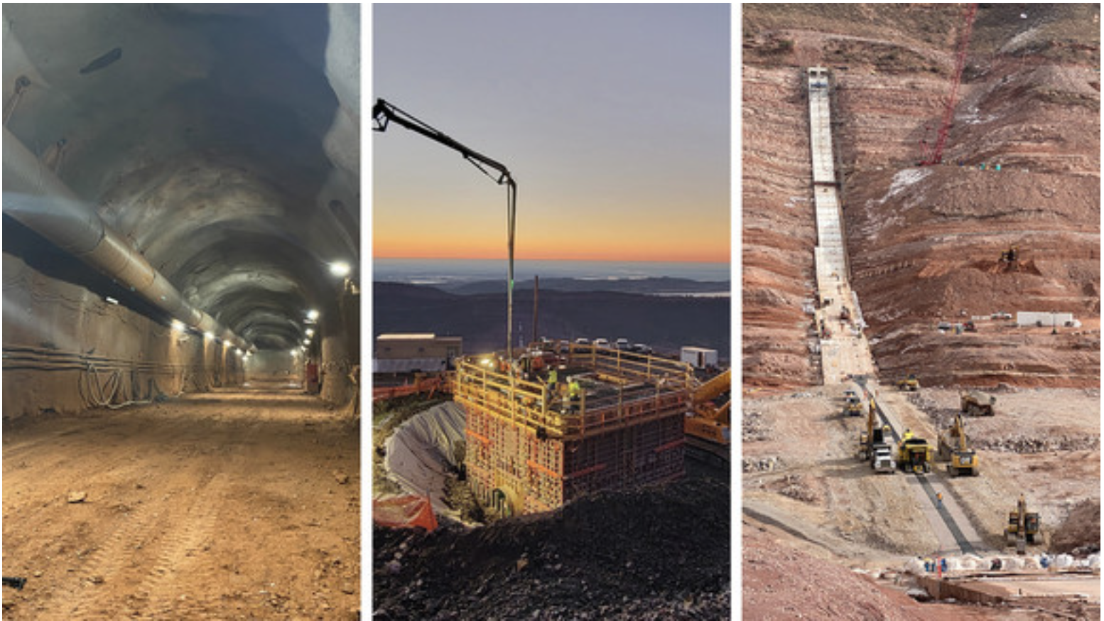
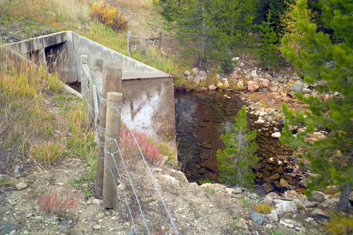
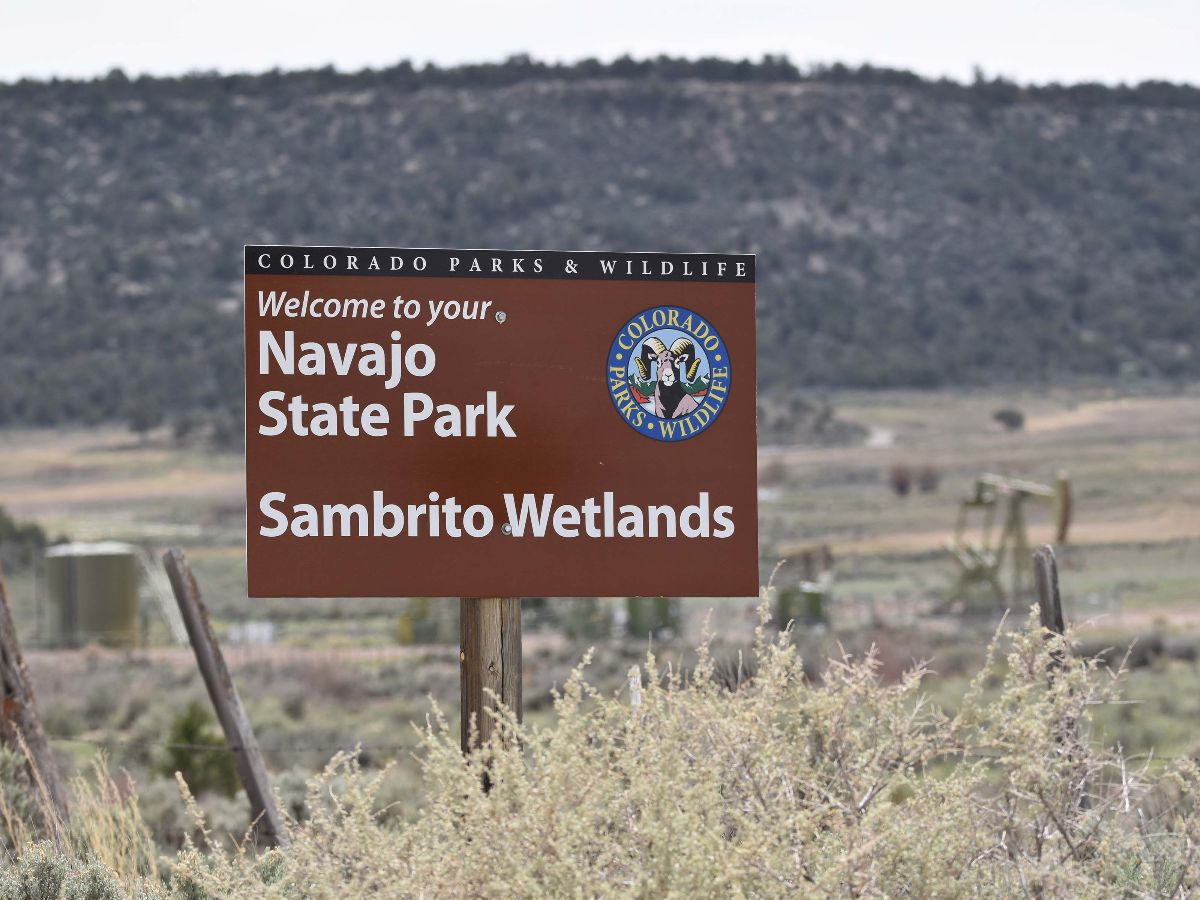
Inlet/Outlet Tunnel (left), Bald Mountain Interconnect (center) and Main Dam (right). Credit: Northern Water
From the Chimney Hollow “E-Newsletter” from Northern Water:
Chimney Hollow Reservoir construction crews made significant progress in 2022. Work started in August 2021 and is scheduled to continue until August 2025. Here are some highlights from this year’s work.
Main Dam Foundation Prep: In November 2022, crews completed the main dam rock excavation, which marked a huge milestone in reservoir construction after 15 months of work on this component.
Hydraulic Asphalt Core: Chimney Hollow construction crews began the asphalt placement in October 2022. For the next two years, the asphalt will be placed in 9-inch increments per lift until the dam reaches a height of about 350 feet. Rockfill and filter/drain construction occur concurrently to complete the embankment construction at any given elevation.
Bald Mountain Interconnect: One of the most time-sensitive aspects of the Chimney Hollow Reservoir Project was the Bald Mountain Interconnect. A shutdown of the Colorado-Big Thompson (C-BT) Project occurred from mid-September through mid-December as crews cut into existing infrastructure to tie in a 126-inch diameter section of steel pipe with a 72-inch diameter steel offtake (known as a wye) to add the ability to deliver water into Chimney Hollow Reservoir from the C-BT Project.
Larimer County and Saddle Dam Access Roads: On Nov. 15, the Larimer County and saddle dam access roads were completed. When the reservoir opens to the public, the Larimer County access road will be the entry road to Chimney Hollow’s future public recreation and open space facilities. The saddle dam road is not a public road and extends to the saddle dam for Northern Water maintenance access.
Downstream Tunnel and Valve Chamber: The downstream tunnel portal and excavation of the 26-foot diameter downstream portion of the tunnel, which runs 667 feet to the center of the main dam was completed in October 2022. A 30-foot diameter valve chamber was also excavated to provide room for mechanical equipment installation and maintenance. A 72-inch diameter steel conduit will be placed inside the tunnel to bring water in and out of Chimney Hollow Reservoir.
Northern Water’s Joe Donnelly and Jeff Drager explain in this video how the new 90,000 acre-foot Chimney Hollow Reservoir, located southwest of Loveland, will be filled with water once construction is completed in 2025.
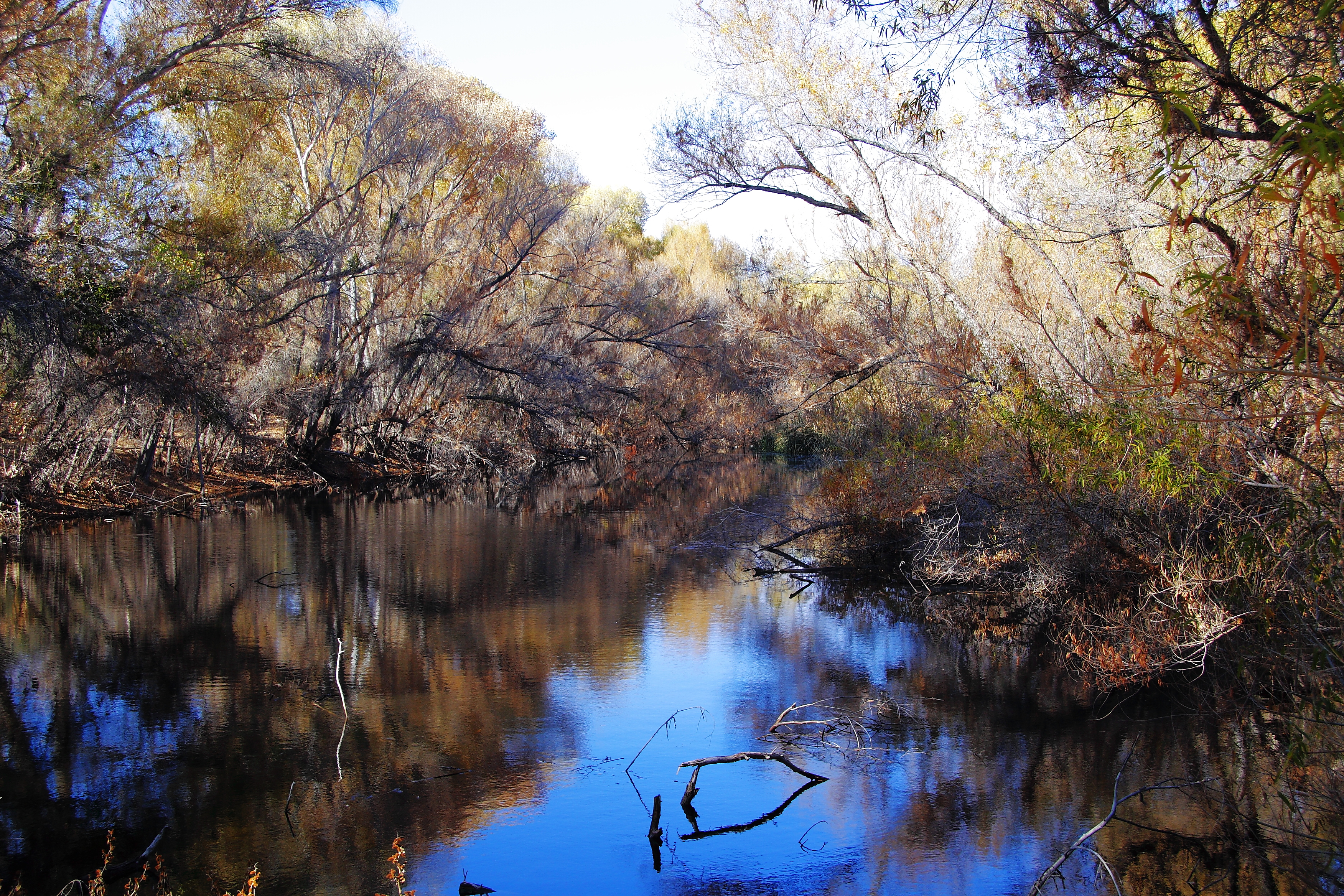
Palm Lake at Hassayampa River Preserve, East side of Wickenburg, Arizona. By John Menard from Phoenix, USA – Palm Lake at Hassayampa River PreserveUploaded by PDTillman, CC BY-SA 2.0, https://commons.wikimedia.org/w/index.php?curid=11769047
That fabled Hassayampa is in the news these days, down in Arizona. The Hassayampa River does exist, by the way: an intermittent stream that flows off the south slopes of the Colorado Plateau, and down through a desert valley west of the sprawling phenomenon of Phoenix, where it joins the Gila River, which in turn joins the Colorado River down near Yuma and the Mexican border.
A new development has been proposed for the lower Hassayampa Valley, catering to those trying to stay out ahead of the sprawl: the Howard Hughes Corporation wants to turn 37,000 acres of Sonoran desert land there, just west of the White Tank Mountains, into a new development, Teravalis, with 100,000 homes for maybe 300,000 people, and 55 million square feet of commercial space. According to a story in the New York Times, ‘Teravalis is seen by local and state leaders as a crowning achievement in a booming real estate market.’
Arizona Rivers Map via Geology.com.
Truly someone has been drinking from the fabled Hassayampa. Teravalis, in fact, plans to tap an aquifer under the Hassayampa Basin for a water supply for this massive development; they will all be drinking from the Hassayampa. Some Arizonans have, however, looked at the naked facts about water supplies in the desert, and the Phoenix area has a law in effect stating that every development has to show evidence that it has a 100-year water supply, and can replace groundwater it consumes. This law was mandated back in 1980 by the Interior Department, as a condition for funding and constructing the Central Arizona Project that brings water 300 miles from the Colorado River to the Phoenix-Tucson corridor. (The law, it should be noted, only applies to urban ‘Active Management Areas,’ and does not apply to the non-urban parts of the state where agriculture consumes a much larger share of the state’s water.)
Teravalis is on hold for now, under that law, until a believable estimate is made of how much water the Hassayampa aquifer actually contains. But – this is only one of several new developments proposed for the Phoenix area alone; remember that Arizona is one of the seven Colorado River states that have been told by the Interior Department that they must collectively cut their water consumption by maybe as much as a third, to prevent a collapse of the region’s water supply system, centered on storage in Mead and Powell Reservoirs.
Yet the Teravalis story is replicated in all seven of those states to some extent; each state has at least one metropolitan area that continues to spread like a cowflop on a flat rock, ever outward into dry lands. We have one right here in the little City of Gunnison where I live, spreading out into our pastureland, that is just completing its infrastructure of pipes and wires. We are a very small ‘city’ of five or six thousand that will never be considered a metropolis or even a micropolis (he bravely projects, back here in 2023), but when our ‘Teravalis’ is built out, mid-century, our current population will have increased by 30 percent, plus or minus.
We seem to be oriented to grow even when we sense that it might be unwise. American historian Richard White commented on this in his history of the West, It’s Your Misfortune and None of My Own. Parsing what he saw as the post-World War II ‘rise of the metropolitan West,’ he credited it mostly to a cycle of planning based on growth, created by ‘what scholars have called growth networks – that is, alliances of bankers, corporate executives, real estate interests, politicians, and labor leaders… [which] gained popular support by arguing that growth equals prosperity.’ We are, in short, culturally and economically organized for growth; it is who and what we are: the growth network creates new jobs for newcomers in the growth industries, building Tervalises for another wave of newcomers who will be employed by the growth industries in building ever newer Teravalises for et cetera et cetera….
Most of the West’s SMAs (Statistical Metropolitan Areas) today boast about the fact that, despite major increases in population, they are actually distributing about the same amount of water they were distributing around 1970. This means that people are using significantly less per capita than they were around 1970 – which is to say: they are conserving water, or using what they use in more efficient fixtures, or both. But this does not necessarily improve their situation. It just ensures enough water for more people to move to their SMA, which (even with sprawl) increases the general density of humanity in the SMA, which causes more traffic congestion, more people in the parks and pools, more queues for restaurants and DMVs, and generally a diminishing quality of life. Conservation loses some of the romantic radiance of civic virtue when the citizen realizes conservation functions mostly to make things available for ever more people.
The development plans do get better and more resource conscious – more ‘watersmart,’ to use a popular buzzword. But they are still intended to fill up with new people who will be using a water resource that we now know is not just limited, but is diminishing. Five or six percent more of it just disappears back to the atmosphere with every degree we increase the ambient temperature – a relentless process of increase that will be facilitated by our development here in the Upper Gunnison, as well as Phoenix’s and everyone else’s. This is not just the usual dire and depressing predictions by scientists; it is what we are already seeing in the diminishing Colorado River water supply – down 20 percent over the last 40 years (faster even than predicted by prescient scientists).
One wants to ask, about that ‘naked fact’ cited in scores of articles about the river just this year: why are there 40 million of us are living in the driest parts of the continent, with more of us coming all the time to fill up these developments? The short answer to that question: we have become a swarming species on the planet – the biologist’s descriptor for a species over which natural ecosystemic processes have lost control. We have been, over the past 10,000 years, a remarkably adaptive species, able to fit into practically every land-based environment, and we have become the dominant species in all of those environments, thriving and increasing at the expense of most of their other animal and plant inhabitants. The deserts are not the only place where there are so many of us; nearly everywhere we go – there we are, lots of us, and more coming all the time.
Through the romantic prisms of what we call civilization, we have been a remarkable success, and all indications are that we plan to become even more successful. It is clear that there is no public will for trying to rein in the swarm, to put limits on our population expansion. When nature tries to control us, bring us back into some degree of balance with the rest of creation, we declare open war on nature and its controls – no COVID or cancer will have its way with us! We fight on all fronts for a world in which people do not die of diseases or malfunctioning parts, a world in which no children die before they are grown, in which everyone can live to be 100, 110, 140, or maybe someday forever.
In other words, we demonstrate through our works and our wars, that we are not going to limit or control ourselves – the first species with the capacity to successfully challenge the often harsh natural systems that restore balance in species swarms. Therefore – so it seems to me – we give ourselves no choice but to make the planet ever more human-centered, to direct ever more of its resources and systems to the meeting of our ever-expanding needs and wants. To put this another way – we can applaud ourselves for quickly finding a vaccine for the COVID virus nature threw at us, but we have to put that in the context of our very active participation in the greatest species die-off since an asteroid took out the dinosaurs and much of the rest of nature’s life project millions of years ago. Is there any other alternative way of seeing what’s going on? Am I missing something?
Updated Colorado River 4-Panel plot thru Water Year 2022 showing reservoirs, flows, temperatures and precipitation. All trends are in the wrong direction. Since original 2017 plot, conditions have deteriorated significantly. Brad Udall via Twitter: https://twitter.com/bradudall/status/1593316262041436160
That is where we find ourselves today, at any rate, in the Colorado River region: confronting the challenge of fitting a finite and even diminishing essential resource to an apparently unlimited demand. ‘Teravalis is seen by local and state leaders as a crowning achievement in a booming real estate market.’ It’s Teravalises all the way down – down, in that particular case, to an unquantified aquifer related to an intermittent desert stream from whose fabulous waters all humankind seems to want to drink. Does anyone really doubt, at this point, that the Hassayampa aquifer, or that aquifer combined with a pipe from some other aquifer, or some even more complex plumbing arrangement, will be proven to be sufficient to provide Teravalis with the radiant vision of a 100-year water supply? It’s the economy, stupid.
As I write here, we are tracking toward a February deadline set by the Interior Department/Bureau of Reclamation, mandating that the ‘seven city-states of Cibola’ come up with massive cuts in the consumptive use of the Colorado River’s waters – at least two million acre-feet, maybe up to four, in order to ‘save’ the river’s storage and distribution system. If the states fail at this (as they did with an earlier Interior deadline), then the Interior Department will make the cuts for them (as they threatened or promised, but didn’t do, when the states failed to meet that earlier deadline). This time, presumably, they really mean it.
This time, the state with the smallest share of the river, Nevada, has drafted up a plan that the other states have agreed is at least a reasonable way to start discussions. If it can be hammered with its current numbers into something acceptable to all the states, even California, it would reduce consumptive use this coming year by around 2.5 million acre-feet. Most of it would come out of the Lower River Basin’s water budget, and would include things like finally acknowledging that their share of the river includes responsibility for the evaporation from their reservoirs and fields. The Upper River Basin would be contributing maybe half a million acre-feet, since its usage quantification already reflects its evaporation plus most of the depletions to date from climate change. (The Upper River Basin produces 80-90 percent of the river’s entire flow.)
The goal, according to Nevada officials, is to share the pain across the entire system. That seems like a reasonable goal – except that it is at odds with the most sacred cow in western water use, the appropriations doctrine, which says that junior appropriators should bear the pain before any senior users are asked to. A ‘naked fact’ that California – holder of the largest senior appropriations on the river – has already been asserting. But as John Entsminger, General Manager of the Southern Nevada Water Authority, has said, ‘If 27 million Americans don’t have water, then those laws will not be followed.’
But… again: what are 27 million, or 40 million, or by mid-century 60 million people doing, demanding water from a modest and diminishing river in the desert lands of the Southwest? I ask myself, being one of them. And can only think to say: Welcome to the Anthropocene. Still all radiant with the color of romance, which lets us still think that a water supply problem is somehow a problem with the water supply…. The second century of the Anthropocene awaits the woke. Stay tuned.
Meanwhile – a belated wish, to all of you who have read this far, for a good year coming: a year filled with wondrous things, like a union between our naked facts and the radiant color of romance that would not be merely cultureporn; a year filled with interesting things that are not merely the fulfillment of a Chinese curse; a year in which we learn to distinguish between a river in trouble and a civilization in trouble.
When we think about the Colorado River water shortage, it’s natural to blame it on the burgeoning population in desert cities like Phoenix and Las Vegas and Los Angeles. Too many people are sucking up too much water to keep their lawns green and their swimming pools full. And as more people move to these cities, their overall water consumption increases proportionally, putting more and more strain on the Colorado River system.
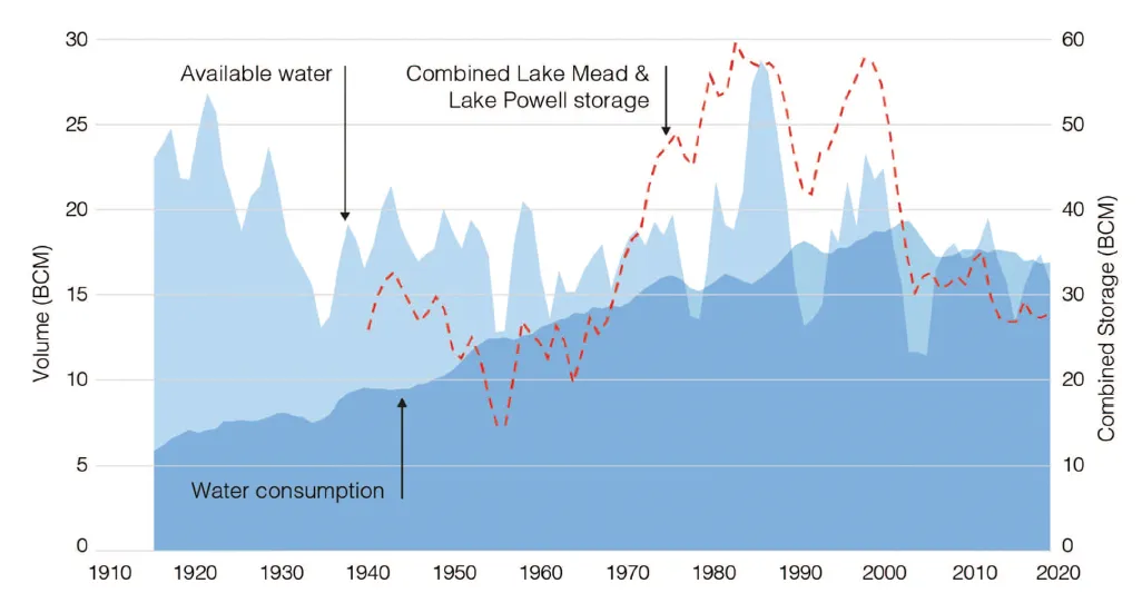
This pattern held true for eight decades after the 1922 signing of the Colorado River Compact: The number of people relying on the river’s waters shot up from less than 1 million to nearly 40 million, and overall water consumption climbed consistently as well, peaking at just under 20 billion cubic meters in 2000.
Suffice it to say, the population has increased a bit in the last century and some. Though it has also decreased in some places: Morenci, Arizona, is now down to 1,500 people; Jerome, Arizona’s population is less than 500; Silverton, Colo., has also shrunk considerably to around 600 year rounders. Source: USGS, 1916.
But then, according to a new study in the Journal of Water Resources Planning and Management by Brian Richter, the pattern was broken. Even as the population of the region continued to shoot up, consumption of Colorado River water actually dropped and then plateaued. That is to say, water use and population growth were decoupled.
Although the finding is counterintuitive, it won’t come as a surprise to those who have been paying close attention to the Colorado River. The crisis that has manifested over the past 20 years is rooted not in a constantly growing population, but in an already overtaxed river diminished by the most severe drought to hit the region in the last 1,800 years.
From Decoupling Urban Water Use from Population Growth in the Colorado River Basin, by Brian D. Richter. Journal of Water Resources Planning and Management, Feb. 2023.
Richter’s study not only confirms that, but it also shows how, when faced with hard limits, we can reduce consumption and work toward more sustainable systems without compromising quality of life.
Richter evaluated water use by 28 municipal utilities that collectively serve about 23 million people. More than half of them had reduced per capita water use enough to decrease total water deliveries by 18%, even as their populations grew by 24%. Albuquerque, Fort Collins, Phoenix, Los Angeles, and San Diego followed the trend. Perhaps the most impressive was the least expected: The Las Vegas metro area added nearly 1 million residents between 2000 and 2020, yet total water deliveries dropped by more than 40 million cubic meters, or 10%, during that same time. In other words, the land of conspicuous overconsumption cut per capita water consumption in half.
While larger cities have been able to cut consumption while growing, mid-sized communities have guzzled and grown at the same time. Figures from Richter.
So does this mean that Las Vegans are suffering from perpetual dehydration? Have the golf courses turned to sand? Have the Bellagio fountains gone dry? Nope, (at least not yet). I’d bet most Las Vegans don’t even notice the difference in their own collective water use, though they might have sensed the gradual disappearance of ornamental turf around the city. Same goes for the other cities with big savings.
That’s because they are realizing these consumption cuts not by rationing water, but by implementing system-wide efficiencies and incentives. New ornamental turf is banned in many of these places, for example, but folks are paid to remove the existing stuff. Same goes for switching to more efficient appliances. Most Las Vegas golf courses are irrigated with treated wastewater and a high-tech, vigilant leak detection and repair program saves hundreds of millions of gallons of water per year. The oil and gas industry ought to hire the Las Vegas leak police to deal with their methane problem.
One of the reasons Las Vegas and other cities were able to make such big gains is because there was so much waste in the system to begin with. Many of the low-hanging fruit have been plucked, but some still remain: Las Vegas’ top residential water users — ultra-wealthy mansion owners — still use tens of thousands of gallons of water per day; water pricing structures are not adequately progressive; and Nevada’s accounting system for Colorado River use disincentivizes indoor water conservation. 1.
Source: Decoupling Urban Water Use from Population Growth in the Colorado River Basin.
1.3 million gallons: Daily water use by the Venetian Casino Resort in Las Vegas, the metro’s largest commercial user.
35,646 gallons: Daily water use by Trophy Hills Residence, LLC, the Las Vegas mansion owned by the late Sheldon Adelson.
25,682 gallons: Daily water use by Via Tivoli LLC, the 75,000 square foot Henderson, Nevada, mansion owned by EBay founder Pierre Omidyar.
112 gallons: Average total daily per capita water use in Las Vegas (includes residential, commercial, industrial).
30 million gallons: Daily water loss to evaporation at Lake Powell in July.
So even Las Vegas still has ample room for cuts. Meanwhile, some cities remain ridiculously wasteful — we’re looking at you, Farmington and St. George and Scottsdale. The good news is that if these smaller cities follow the larger metros’ lead, they could realize significant cuts. The bad news is that it still won’t be nearly enough to save the Colorado River system on which so many of us depend.
And even if population and water consumption have been partially decoupled, they aren’t completely divorced. Las Vegas and Phoenix and L.A. eventually will hit a limit of per capita cuts, at which point a growing population will again cause overall consumption to increase. Thing is, there is no extra water in the system to sustain it, and the old practice of cities “buying and drying” farms and transferring the water rights to new housing development is untenable. Any agricultural water saved through efficiency or fallowing or crop-changes must go back to the river, not to new subdivisions.
For the last century, the Southwestern Growth Machine — fueled by greed, cheap and dirty power, and the mirage of abundant water — has churned away relentlessly. Now it’s time to shut it down and to practice not only water consumption-control, but also growth control — decoupling or not.
Colorado River “Beginnings”. Photo: Brent Gardner-Smith/Aspen Journalism
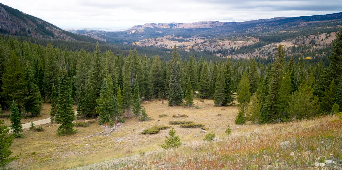
The upper reaches of Haggarty Creek on the Medicine Bow National Forest. (Angus M. Thuermer, Jr./WyoFile)
Click the link to read the article on the WyoFile website (Angus M. Thuermer):
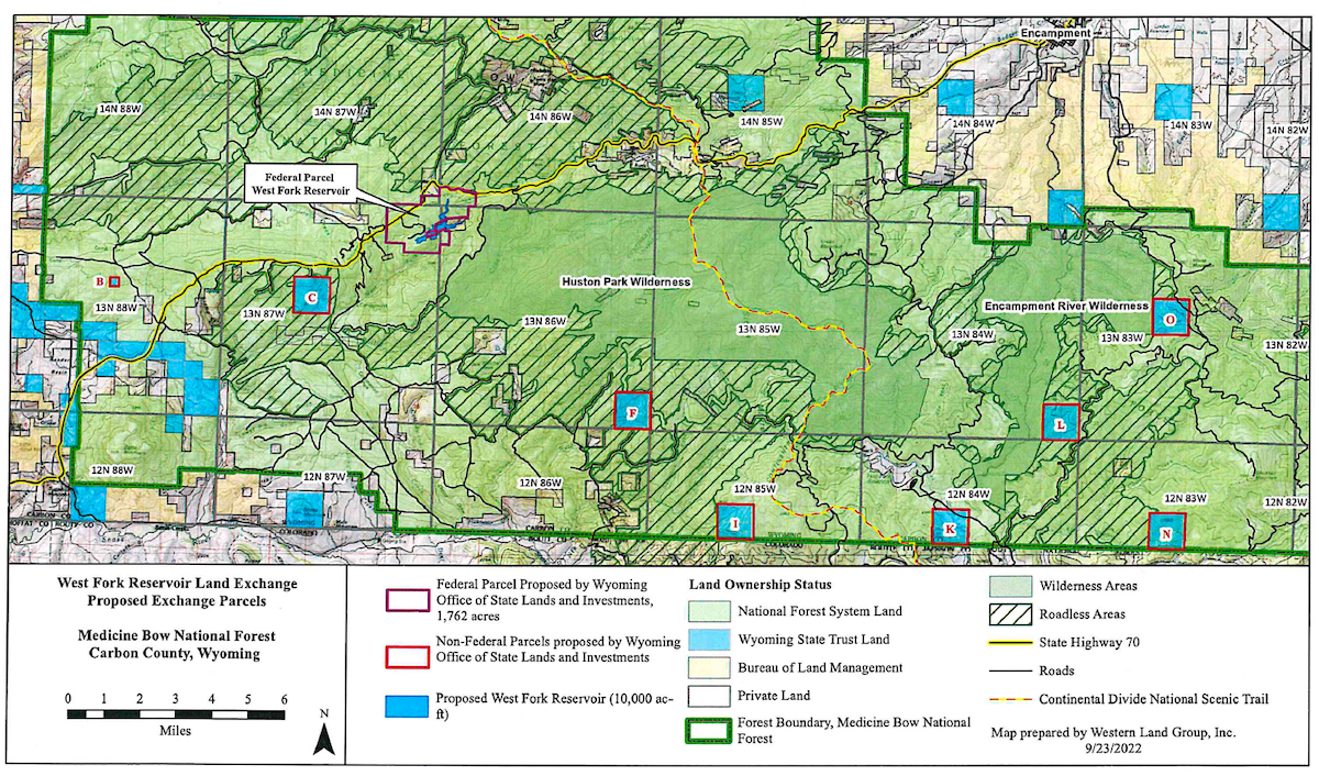
Above the Colorado-Wyoming border, the Sierra Madre Mountain snowpack holds water that ranchers say flows downstream too fast. Some question whether a proposed 10,000-acre-foot reservoir is pork or progress.
As officials this week outline plans for a 264-foot-high concrete dam proposed for a wooded canyon in the Medicine Bow National Forest, irrigators and critics remain divided over the project’s benefits and impacts. The two sides disagree whether the estimated $80-million structure and accompanying 130-acre reservoir are pork or progress, boon or bane.
Federal officials begin receiving public comments on the proposed dam on the West Fork of Battle Creek in Carbon County as ranchers and environmentalists disagree over whether 450,000 cubic yards of concrete should plug a forested gorge and whether federal and state agencies are conducting environmental examinations appropriately. In what one official admitted is a complex process with parallel reviews, two federal agencies will make key findings to resolve the project’s fate.
The federal Natural Resource Conservation Service will examine dam construction and alternatives in an environmental impact statement. Meantime, the U.S. Forest Service will launch a separate “feasibility study” todecide whether it should take part in an estimated 6,282-acre land exchange facilitating construction of the dam. The study will determine whether trading the federal dam site to Wyomining “is in the best interest of the American public,” Medicine Bow spokesman Aaron Voos said.
Proponents want the dam and reservoir to yield 6,500 acre-feet of late-season irrigation for between 67-100 irrigators in Wyoming and Colorado. The 10,000 acre-foot impoundment would hold 1,500 acre-feet as a minimum bypass flow for fish and wildlife. The state would pay for most of the estimated $80 million cost, a figure calculated in 2017.
“We would like to have a project here because it’s good for our valley,” said Pat O’Toole, a former state representative who ranches along the Little Snake River. “The public interest is clearly that the storage project [aids] biodiversity” and boosts food production while creating “a really healthy landscape.”
[…]
The land exchange is an end-run around environmental reviews, he said, an assertion dam supporters and review agencies reject. [Gary] Wockner is worried that Medicine Bow officials won’t apply the same scrutiny to the land exchange that they would to the construction of a dam on National Forest property, he said. Building on federal land would require a more extensive review, he said, echoing dam backers’ own public statements.
Medicine Bow spokesman Voos rejected the assertion his agency is shirking its responsibilities. It is speculation to assert what level of review a proposal to build the dam on federal property would require, he said.
Wyoming agrees the process is sound. “It wouldn’t limit the environmental review at all,” Jason Crowder, deputy director of the Office of State Lands and Investments, told WyoFile.
In addition to its public-interest swap determination, the Medicine Bow is participating in a separate environmental impact review and statement — conducted by the Natural Resources Conservation Service — that will consider environmental and social impacts of dam and reservoir construction and operation. All that “satisfies the environmental review requirements for the land exchange,” Voos said.
Dwindling basin flows
At the upper reaches of the Colorado River Basin, where dwindling flows put seven Western states and Mexico at odds over historic and future use, the project comes at an uneasy time. It will test Wyoming’s willingness to impound and use what it believes river laws allow, despite an arid landscape of dwindling Colorado River flows, oversubscribed demands, climate change and growth.
Federal regulations state that a land exchange can take place only if the public interest “will be well served.”
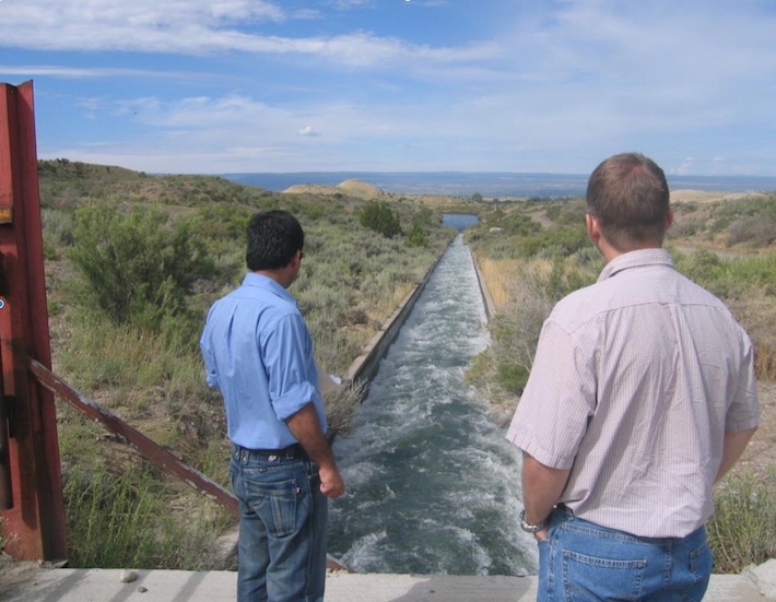
One benefit to the Medicine Bow could be acquiring 640 acres of state-owned school-trust sections inside the national forest. “Quite a few of them are either in or adjacent to [a] wilderness area or roadless areas,” said Jonathan Bowler, watermaster for the Savery-Little Snake River Water Conservancy District.
Little Snake River agricultural lands along the Colorado-Wyoming border. Angus M. Thuermer, Jr./WyoFile)
“The public could potentially see an expansion of roadless and wilderness in those areas,” he said.
The reservoir itself would flood land within about a half mile of the boundary of the Medicine Bow’s 31,057-acre Huston Park Wilderness Area, according to maps.
Bowler outlined other ways existing irrigation aids the environment; the dam would expand those benefits.
“You’ve got hundreds of ranchers pretty much doing the work of beavers to build riparian areas and habitat,” he said. Such irrigation-induced wetlands today cover more than 7,000 acres in the area, he said.
Birds and water at Bosque de Apache New Mexico November 9, 2022. Photo credit: Abby Burk
Irrigation aids amphibians and species like sandhill cranes that migrate to the Bosque del Apache National Wildlife Refuge in New Mexico, he said. “Our irrigation actually directly benefits that mating grounds down there that’s quite a tourist attraction.” Elk and other wildlife benefit from the open private land, he said.
Irrigation “basically fills up the soil … the largest reservoir that we have,” he said. When that moisture starts coming back out to the river, “that means that our rivers are higher [in] flow [in] late summer, early fall than historically they were.”
Wyoming calculates those returning flows — about 45% of what’s diverted onto fields — as water that can be used for irrigation again and counted as a benefit, according to a Water Development Office study.
“That late-season irrigation especially can help cool down river temperatures, which helps to provide for those big game populations as well as fish and other wildlife,” Bowler said.
Cutthroat trout historic range via Western Trout
The dam also could benefit Colorado River cutthroat trout because it would be an upstream barrier to competitors, helping fisheries managers enlarge a sanctuary for the species in and above the reservoir.
Said O’Toole, “this is may be as conservation-minded a place I know of in the western United States.”
Environmental review
…Wyoming wants 1,700 acres of Forest Service land for the dam and would analyze the value of between 2,024 and 4,400 acres of Wyoming school-trust land inside the Medicine Bow for the trade. Public announcements differ over the state acreage to be considered for trade.
The valley in which the West Fork dam and reservoir would be constructed. (Angus M. Thuermer, Jr./WyoFile)
State and federal officials agree a land swap would make approval of the 130-acre reservoir easier. Wyoming’s exchange request states that a land swap “would eliminate the need for a USFS special use permit.”
Federal land ownership of the dam site “adds millions of dollars to that [permitting] process,” Harry LaBonde, former director of the WWDO told lawmakers in 2018. “Dealing with the Forest Service … very much complicates the NEPA process,” he said, and an exchange “very much streamlines” potential development.
Dam proponents “were running into a bit of a roadblock with Forest Service on Forest-Service-managed land,” OSLI Deputy Director Crowder told the Wyoming Board of Land Commissioners in 2021.
The Medicine Bow told Wyoming officials that building on federal, not state, land “would not be the best approach just due to all the regulations that would come along with a [required] special use permit,” Voos said in an interview. “And so I think that [land swap] has been our suggestion.”
The value of exchanged parcels can be balanced by adjusting the acreage or paying for a difference, according to Wyoming’s proposal.
Any increase in federal acreage — the state offered 4,400 acres for analysis and potential trade for 1,700 acres of Medicine Bow land — could run afoul of Carbon County’s Natural Resource Management Plan. That plan supports valuable exchanges but also calls for “no net loss of private or state lands in exchange for federal lands.”
Gov. Mark Gordon, too, “is not supportive of the federal government expanding their [sic] estate in Wyoming,” Gordon’s spokesman Michael Pearlman told WyoFile when the governor protested the 35,670-acre conservation purchase of the private Marton Ranch along the North Platte River last year.
Of the 1,700 acres of Medicine Bow property Wyoming would acquire, the state wants 1,336 acres for the dam and reservoir itself and another 426 acres covering parts of Haggarty Creek and the Belvidere Ditch, site of a water spatamong area irrigators.
Owning all the property would “provide for the efficient operation of the reservoir and surrounding lands,” the state said in its land-swap proposal.
The state would lease the newly acquired land to the Water Development Commission, which would eventually transfer ownership to Carbon County or some other entity, according to plans. That final owner would be responsible for compensating the school trust — whose land the state would trade away.
A mining company that owns land at the reservoir site also would be involved with the project. American Milling LP of Cahokia, Illinois owns about 124 acres inside the national forest at the proposed site of the reservoir. The Carbon County assessor lists the market value of the property, site of mineral claims, at $40,675. Wyoming would presumably have to acquire that property too, or somehow arrange for it to be flooded.
WyoFile did not receive a response to a certified letter sent to the company seeking comment on Wyoming’s plans to inundate the private land.
Equal values
The Forest Service must show that values and public objectives of the state parcels “equal or exceed” those that would be swapped, regulations state. Medicine Bow land that would become the dam site must “not substantially conflict with established management objectives on adjacent Federal lands,” the Forest Service said.
Medicine Bow officials last week couldn’t immediately outline those objectives.
A WWDO study, however, listed the benefits of a new dam, saying it would generate $73.7 million in public benefits. Reservoir releases would be coordinated with those from the High Savery Dam.
A fish barrier on Haggarty Creek provides an upstream sanctuary for Colorado River cutthroat trout. (Angus M. Thuermer, Jr./WyoFile)
Critics have questioned the accounting of benefits, including rosy projections for recreational revenue and the acreage that would benefit from irrigation.
The cost/benefit ratio allows the state to reduce the required contributions from irrigation districts from the typical 33% to 8% of construction costs.
Wyoming, however, has seen costs for dam construction increase dramatically in recent years, potentially upsetting the cost/benefit ratio. The environmental review will update those figures, Jason Mead, interim director of the WWDO, wrote in an email.
Construction would require an estimated 450,000 cubic yards of concrete, according to an application to appropriate water filed with the state engineer in 2014. The Forest Service public-interest determination and separate NRCS environmental impact statement seek to examine the construction plan through two separate reviews.
A 70-step process
The parallel review process is complex, Voos said. The Medicine Bow is engaged with the federal Natural Resources Conservation Service and the U.S. Army Corps of Engineers in a larger analysis of the dam’s environmental and social impact. Other state and federal agencies also are involved.
The separate Forest Service public-interest decision is entwined in that process, both to be explained at public meetings in the region on Tuesday, Wednesday and Thursday.
The public-interest determination, “that’s kind of a parallel process to the land exchange,” Voos said. “We are piggybacking in essence, on those public meetings,” to get comments on the swap.
“We have a full, almost … 70-step process that we have to go through for the land exchange,” Voos said. Reservoir construction on National Forest System lands “is not commonplace,” the Medicine Bow said in a statement.
After determining the public-interest benefit, “we proceed or don’t proceed with the rest of the land exchange process,” Voos said. The Forest Service is “not for or against the project.”
[…]
Interested parties can read a legal notice published by the NRCS or weigh in online, by post or hand-delivery. The comments go to the NRCS, which will forward relevant land-swap ones to the Forest Service, Voos said. Meetingsoutlining the scope of the analysis and potential alternatives will be held Tuesday, Wednesday and Thursday in Craig, Colorado, and Baggs and Saratoga respectively.
Updated Colorado River 4-Panel plot thru Water Year 2022 showing reservoirs, flows, temperatures and precipitation. All trends are in the wrong direction. Since original 2017 plot, conditions have deteriorated significantly. Brad Udall via Twitter: https://twitter.com/bradudall/status/1593316262041436160
Click the link to read the article on the KUNR website (Kaleb Roedel). Here’s an excerpt:
In Nevada, more than $1.7 million will pay for Las Vegas Valley homeowners using septic tanks to convert to the municipal sewer system. This recycles water back into Lake Mead, which is fed by the drought-stricken Colorado River, said Doa Ross, deputy general manager of engineering for the Southern Nevada Water Authority…
In Colorado, $5 million will be used to build a collector well in Aurora. On the state’s Western Slope, Deutsch Domestic Water Company is getting $585,000 for storage and efficiency improvements…
In New Mexico, $5 million will go toward a groundwater well in Gallup. Another $1.5 million will help pay for new tools and strategies in regions with acequia water distribution systems, which are gravity-fed earthen canals that divert stream flow for distribution to fields…
Utah is getting the largest chunk of funds among states in the Mountain West. The state has seven different projects receiving a total of about $22.5 million
Wheat fields along the Colorado River at the Colorado River Indian Tribes Reservation. Wheat, alfalfa and melons are among the most important crops here. By Maunus at English Wikipedia, CC BY-SA 3.0, https://commons.wikimedia.org/w/index.php?curid=47854613
Click the link to read the article on the AZCentral.com website (Debra Utacia Krol). Here’s an excerpt:
Five Arizona tribes celebrated after President Joe Biden signed legislation that secured water rights, funding to develop water infrastructure and historically important tribal lands. Some tribes have been pushing for these bills for years, including the Colorado River Indian Tribes, which worked for more than two decades to secure the right to lease a portion of its Colorado River allotment. The bills were passed in the waning days of the 117th Congress. The Colorado River Indian Tribes Water Resiliency Act, the Hualapai Tribe Water Rights Settlement Act, and the White Mountain Apache Tribe Water Rights Quantification Act were signed by Biden Jan. 5.
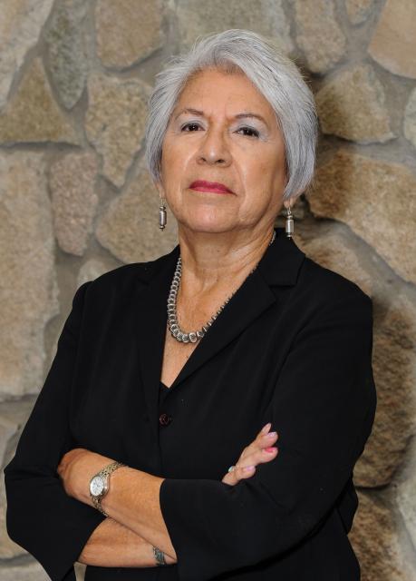
Amelia Flores, chairwoman of the Colorado River Indian Tribes. (Source: CRIT)
The Colorado River Indian Tribes, known as CRIT, had sought to lease part of its 719,248 acre-feet Colorado River allotment for more than 20 years, said CRIT Chairwoman Amelia Flores. The tribe has saved a portion of its allotment using conservation measures and will use the revenues from leasing it to help stabilize its economy and enable water service extensions to tribal members, she said. CRIT, which operates a large farm and casino, also plans to improve its canal system and conserve even more water. More importantly, Flores said, these measures will enable the tribe to help save the life of the river.
“The river’s the person. The river can’t speak for itself. And we as stewards need to step up and protect the river,” she said.
The Mojave and Chemehuevi have lived in the Colorado River Valley and the surrounding lands for millennia, and in recent years, Navajo and Hopi people relocated to the area. All four tribal cultures hold water as the source of life…Further up the river, the Hualapai Tribe finally secured a small water settlement that will provide a huge boost to its economy and community. The settlement provides 4,000 acre-feet from the river and authorizes the construction of a pipeline and other infrastructure to deliver the water to the tribe’s biggest enterprise, Grand Canyon West. Water will also be delivered to homes…The 2,300-member tribe had pushed for more than a decade to secure the allotment from the Colorado River. The tribe’s lands lie on the south side of the Grand Canyon along 108 miles of the river…
In eastern Arizona, the White Mountain Apache Tribe Water Rights Quantification Act amends a 2010 water rights settlement for the 15,000-member tribe. It authorizes federal funding and extends the time the tribe needed to complete its rural water system and Miner Flat Fam project.
BKW Farms is a model for what sustainable water consumption and conservation can look like in the heart of Arizona’s Sonoran Desert | Photo: Sinjin Eberle
Brian Wong has a lot on his shoulders. A third-generation farmer, Wong grows crops — including nearly extinct heritage grains like white Sonora wheat — on 4,500 acres in the heart of the parched Sonoran Desert, about 25 minutes northwest of Tucson, Arizona. Bakeries, restaurants, breweries, and flour mills as far away as Minnesota and Florida rely on his grain to sustain their own businesses.
Wong’s BKW Farms is among the 80 percent of the state’s agricultural producers that rely on the Colorado River to irrigate their crops. And with the Colorado at precariously low levels, his family business faces its largest challenge in nearly 85 years. “We have a great understanding of and place great importance on water,” Wong says. “Water is something you need in almost every aspect of agriculture. Everything we grow is irrigated. We need to have a water source to put on the crops so we can continue growing food.”
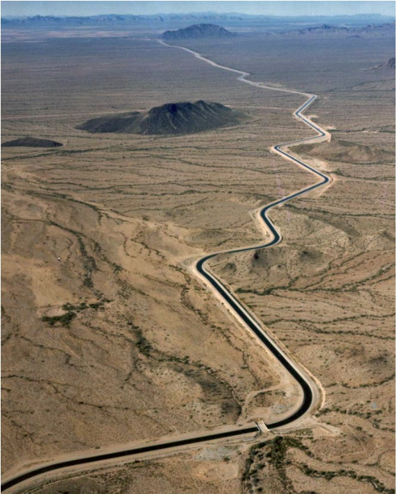
The Central Arizona Aqueduct delivers water from the Colorado River. Photo credit: U.S. Bureau of Reclamation
All of the water irrigating Wong’s farm arrives via the Central Arizona Project (CAP), a 336-mile canal system that shuttles Colorado River water to customers throughout the state. Altogether, the Colorado irrigates 5 million acres of farm and ranch land across seven Southwestern states and Mexico. It supplies 40 million people with drinking water and supports a $1.4 trillion economy.
But climate change, extreme drought, and explosive population growth are taking an enormous toll on the river. The Colorado and its two largest reservoirs, Lake Powell and Lake Mead, dwindled to calamitously low levels in 2022, forcing the U.S. Department of the Interior to declare, for the first time in history, a Tier 1 Water Shortage. The declaration triggered deep cuts in the volume of Colorado River water delivered to Arizona, Nevada, California, and Mexico. Arizona agriculture took the biggest hit because CAP is on par to get 30 percent less water from the shrinking river. Even deeper restrictions will go into effect in 2023, with cities and Tribes shouldering more of the brunt.
Alongside farmers like Wong, American Rivers is urgently working together with partners at utilities, municipalities, and conservation groups to fix the massive imbalance between demand and a shrinking Colorado River.
Colorado River, AZ | Photo by Fred Phillips
From working with ranchers to restore habitat in the river’s headwaters, to encouraging municipalities to use less and eliminate unnecessary uses of valuable Colorado River water, to working on new guidelines for long-term management of the river, American Rivers is involved in decisions that span 1,700 miles of the Colorado River, from its headwaters in Colorado to its delta in Mexico.
“The hard truth is, there just isn’t enough water to go around for everyone,” Wong says.
We have to learn to live with a smaller Colorado River. Wong says the way forward is by partnering with advocates like American Rivers, who work with policymakers and stakeholders to elevate stories and shape water-management strategies into the future.
The bottom line is that “I” doesn’t work. We all rely on rivers, and water, and their continued existence. Our future demands that we invest boldly and immediately in strategies that will work — and that will build for all of us the kind of future we want for our children.
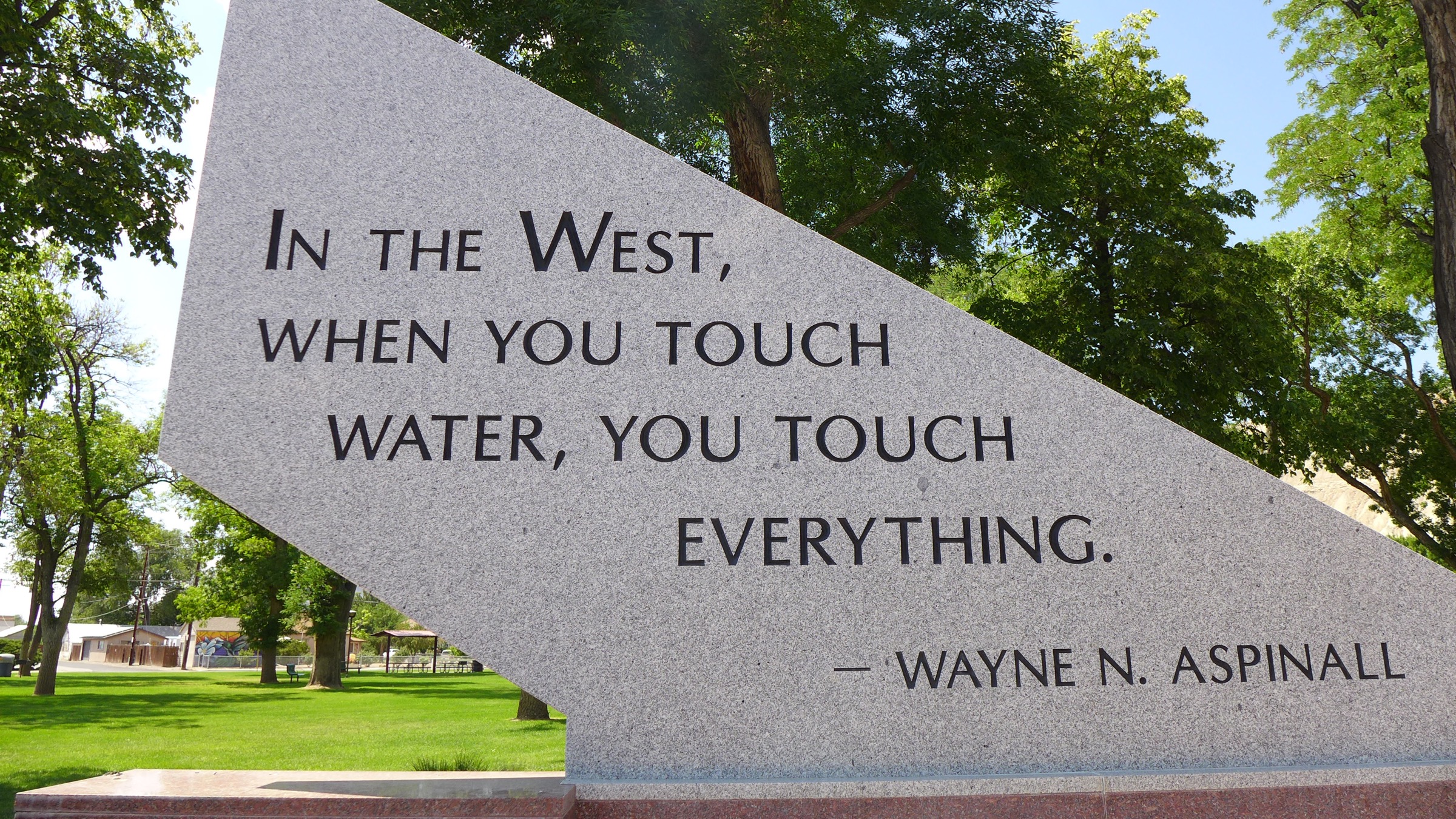
Part of the memorial to Wayne Aspinall in Palisade. Aspinall, a Democrat, is a legend in the water sector, and is the namesake of the annual award given by the Colorado Water Congress. Photo: Brent Gardner-Smith/Aspen Journalism
From email from Reclamation (Erik Knight):
The next coordination meeting for the operation of the Aspinall Unit is scheduled for Thursday, January 19th, 2023 at 1:00 pm
As of now, the meeting is planned to be held in person as well as virtually.
The meeting is planned to be held at the Western Colorado Area Office in Grand Junction, CO. Even if the in-person meeting needs to be cancelled, the meeting will still be held via webinar.
Information for connecting to the meeting virtually will be emailed out prior to the meeting, along with the agenda and handouts.
U.S. Sens. John Hickenlooper and Mitt Romney, along with Colorado Rep. Joe Neguse, have teamed up to ensure the continuation of conservation programs aimed at protecting native and endangered fish species through the Upper Colorado and San Juan Basins Recovery Act. The recovery act has been included with the Fiscal Year 2023 Omnibus Government Funding Bill that has already been passed by the U.S. House of Representatives and is awaiting approval from President Joe Biden…
The Upper Colorado and San Juan River Recovery Programs are set to expire on Sept. 30. The recovery act would extend any programs that currently study, monitor and stock four endangered fish species of the Upper Colorado and San Juan rivers through the end of 2024…
{Senator] Romney also showed interest in the impact of human activity and climate change on the Colorado River and its native species in 2021, when he went on a rafting trip with Sen. Michael Bennett and the Colorado River Commissioner and director of the Colorado Water Conservation Board, Becky Mitchell.
The system for irrigating is vastly different between Wyoming and Imperial Valley, and because of this, water negotiators of the region have vastly different points of view. In the Green River Basin, there are 2500 gates diverting water onto ranchers’ lands, but in the greater scheme of things, the basin is essentially a collector system. Some of those far-flung gates are “unregulated,” or unmonitored. The Green River has 2,000 named natural tributaries. Accurately measuring the supply and consumption of water in such a system is a work in progress.
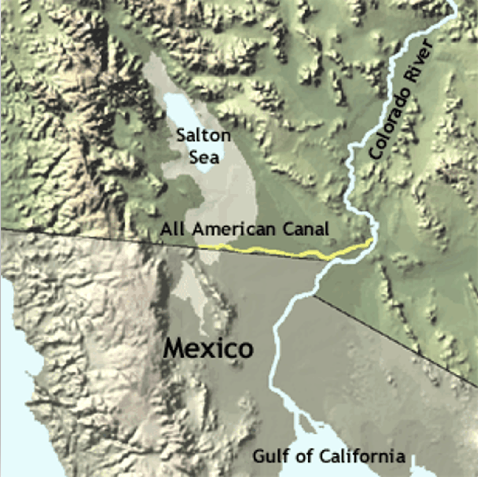
The All American Canal diverts water from the Lower Colorado River to irrigate crops in California’s Imperial Valley and supply 9 cities. Graphic credit: USGS
In the Imperial Valley, we have one gate diverting water from the Colorado River. It is where Imperial Dam turns water into the All-American Canal. While the Green River Basin is a collector system like the roots of a tree, ours is a distribution system like the branches to the leaves. The IID has 5500 gates. Since every one of them is monitored by the IID, water supply and consumption are easy to measure with gauges throughout the system.
Water management is a world apart as well. In the Green River Basin, there are thirty-seven small water distribution agencies, both public and privately owned, often with zero or a handful of fulltime employees. There are irrigation districts, conservancy districts, ditch companies, and canal companies. Ranchers, and often non-agricultural property owners, pay an assessment, or a flat fee, or a per-acre fee, or a price per share for water delivery. The water itself is owned by the state of Wyoming and is made available for free. The overseer of all this is the Wyoming State Engineer, which in turn has a representative on the Upper Colorado River Commission, the governing agencies for the Upper Basin states.
In the Imperial Valley, the Imperial Irrigation District is the sole holder of water rights to Colorado River water and the sole manager for water distribution. Here, as in all the Lower Basin States, the Bureau of Reclamation is our overseer. With nearly 500 employees in its water division, IID outguns the whole state of Wyoming for water workers about 2 to 1. The Bureau also supplies IID’s 3.1 million acre-feet of water for free, and IID charges farmers $20 an acre-foot (af), a fee subsidized by revenue from the transfer of water to the San Diego County Water Authority. Industrial water users pay a much higher fee…
So far, the cuts that Mother Nature has forced on Wyoming and others in the Upper Basin states, and the cuts agreed to by Arizona, Nevada, and California, are far below the amount necessary to save the reservoirs from circling the drain in the next few years. Negotiators have until the end of this month to reach consensus on a plan to satisfy the Bureau of Reclamation’s demand for 2-4 million acre-feet of cuts in water use next year. We’re all unhappy in our own way on the Colorado River. Like the sparsely populated Cowboy state, we can only fight the good fight against the odds.
Sites in Archuleta County received between 6.3 and 17.8 inches of snow in the storms be- tween Saturday, Dec. 31, 2022, and Jan. 4, according to the Community Collaborative Rain Hail and Snow Network (CoCoRaHS) website. Higher snowfall totals were concentrated in the northern and southern portions of the county, with the highest reported precipitation amount located east of Chromo, according to CoCoRaHS. A Jan. 4 report from Wolf Creek Ski Area that was issued at approximately 6 a.m. indicated that Wolf Creek had received 11 inches of snow in the previous 24 hours and 59 inches in the last week, bringing the midway snow depth to 83 inches and the season-to-date snowfall total to 154 inches.
According to the U.S. Department of Agriculture National Water and Climate Center’s snowpack report, the Wolf Creek summit, at 11,000 feet of elevation, had 15.9 inches of snow water equivalent as of noon on Wednesday, Jan. 4. The Wolf Creek summit was at 106 percent of the Jan. 4 snowpack median. The San Miguel, Dolores, Animas and San Juan river basins were at 125 percent of the Jan. 4 median in terms of snowpack…
River report
Stream flow for the San Juan River at approximately 10 a.m. on Jan. 4 was 73.8 cubic feet per second (cfs), according to the U.S. Geological Service National Water Dashboard. This reading is up slightly from last week’s reading of 72.5 cfs at 10 a.m. on Dec. 28, 2022.
Click the link to access the paper from the Utah State University website (John C. Schmidt, Maggi Kraft, Daphnee Tuzlak, and Alex Walker | November 10, 2016):
The Fill Mead First (FMF) plan would establish Lake Mead reservoir as the primary water storage facility of the main-stem Colorado River and would relegate Lake Powell reservoir to a secondary water storage facility to be used only when Lake Mead is full. The objectives of the FMF plan are to re-expose some of Glen Canyon’s sandstone walls that are now inundated, begin the process of re-creating a riverine ecosystem in Glen Canyon, restore a more natural stream-flow, temperature, and sediment-supply regime of the Colorado River in the Grand Canyon ecosystem, and reduce system-wide water losses caused by evaporation and movement of reservoir water into ground-water storage. The FMF plan would be implemented in three phases. Phase I would involve lowering Lake Powell to the minimum elevation at which hydroelectricity can still be produced (called minimum power pool elevation): 3490 ft asl (feet above sea level). At this elevation, the water surface area of Lake Powell is approximately 77 mi2, which is 31% of the surface area when the reservoir is full. Phase II of the FMF plan would involve lowering Lake Powell to dead pool elevation (3370 ft asl), abandoning hydroelectricity generation, and releasing water only through the river outlets. The water surface area of Lake Powell at dead pool is approximately 32 mi2 and is 13% of the reservoir surface area when it is full. Implementation of Phase III would necessitate drilling new diversion tunnels around Glen Canyon Dam in order to eliminate all water storage at Lake Powell. In this paper, we summarize the FMF plan and identify critical details about the plan’s implementation that are presently unknown. We estimate changes in evaporation losses and ground-water storage that would occur if the FMF plan was implemented, based on review of existing data and published reports. We also discuss significant river-ecosystem issues that would arise if the plan was implemented.
A series of atmospheric river storms has brought California heavy rains and above-average snowpack across the Sierra Nevada, but experts say the state still needs many more storms to begin to emerge from drought. The Sierra Nevada snowpack measures 174% of average for this time of year, but there are still three months left in the snow season, and the snow that has fallen to date remains just 64% of the April 1 average.
“It’s definitely a very exciting start to the year and a very promising start to the year. But we just need the storm train to keep coming through,” said Andrew Schwartz, lead scientist at UC Berkeley’s Central Sierra Snow Laboratory.
Storms swept in from the Pacific last week, bringing torrential rains and triggering major flooding in the Central Valley and other areas…
State water officials held their first manual snow survey of the year Tuesday at the Phillips Station snow course, one of more than 260 sites across the Sierra Nevada where the state tracks the snowpack…California’s largest reservoirs remain very low after the state’s driest three years on record. Shasta Lake is at 34% of capacity, while Lake Oroville is 38% full. Yet the start of this wet season has brought California some much-needed relief. State officials said the snowpack for this time of year is the third largest in the last 40 years, ranking behind 1983 and 2011.
The Colorado River flows through Gore Canyon in Colorado. Photo: Mitch Tobin/The Water Desk
It’s early January, and while snow season in the Southern Rockies continues for another three months, we already see snowpack at 59% of the seasonal average. That is something to celebrate, as the Colorado River Basin has been in an extended drought going on 24 years, with consequences for people, birds and every other living thing that depend on rivers in this region. But the abundant start to the snow season does not mean Colorado River managers get a reprieve from their aggressive efforts to reduce water use and reform Colorado River operations.
In recent years we have seen “above average” early season snowpack turn into below average snowpack and far-below-average runoff. In 2021 for instance, 85% of average snowpack turned into runoff of 36%. A variety of factors created these dynamics, including fewer storms later in the snow season, warmer temperatures both increasing evaporation and evapotranspiration (evaporation from plants) and drying out soils which then soak up melting snow. Of course, we don’t yet know this how this year will turn out for Colorado River water supply. But we know it is too early to draw conclusions, other than – gee, sure would be nice if it keeps snowing.
With Colorado River reservoirs two-thirds empty, federal and state water managers have sounded alarms, pointing to the risk of infrastructure failure and even the ability to deliver water and hydroelectric power to tens of millions of people. The available storage space in the reservoirs can hold more than three years of the Colorado River’s average undepleted flow. So even a bomber snow season is not going to end the drought. Tom Buschatzke, who leads the Arizona Department of Water Resources acknowledged this in a recent interview with CNN: “One good year doesn’t fix us—even a couple of good years doesn’t fix us…We’ve got to rebuild that bank account.”
With climate warming projected to increase, there’s an urgent need to balance Colorado River water uses with supply, even to reduce uses below supply so that there’s less risk to the dams, to people and to nature. Best to keep the pedal to the floor on reforming Colorado River management—because while winter storms are inherently good for water supplies, there is no guarantee winters will be long, sustained, or consistent.
Agriculture is the main economic venture on CRIT’s reservation, where a range of crops like alfalfa, cotton and sorghum thrive in the rich soil along the banks of the Colorado River. (Source: CRIT)
Click the link to read the article on the Associated Press website (Felicia Fonseca). Here’s an excerpt:
Amelia Flores, chairwoman of the Colorado River Indian Tribes. (Source: CRIT)
A Native American tribe that has one of the largest and most secure rights to Colorado River water now has approval to lease some of it in Arizona, a state that’s been hardest hit by cuts to its water supply and is on a perpetual search for more. President Joe Biden signed legislation Thursday giving leasing authority to the Colorado River Indian Tribes, whose reservation tracks its namesake on the Arizona-California border. Biden also approved a water rights settlement for the Hualapai Tribe and authorized additional funding to complete water projects for the White Mountain Apache Tribe.
The Colorado River Indian Tribes passed a resolution in 2020 to seek the federal legislation to help bolster the tribe’s economy and improve housing, health care and education on the reservation. Revenue from water leases also will help fund a nursing home, substance abuse….The tribe has the right to divert more than 662,000 acre-feet of Colorado River water in Arizona but hasn’t taken full advantage because it lacks the infrastructure. It also has rights to nearly 57,000 acre-feet of water in California…
[Amelia] Flores said the tribe is committed to helping its neighbors and maintaining the habitat along the river as water becomes more scarce and others face deeper cuts.
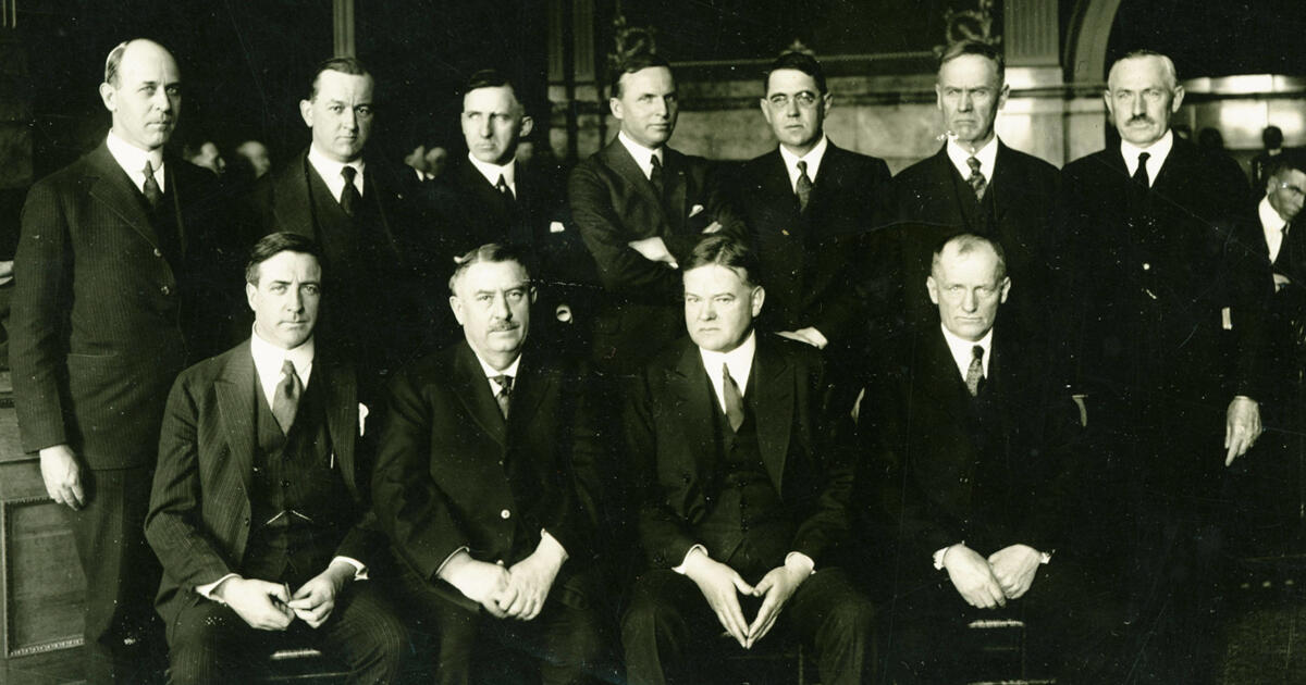
A March 31, 1922 photo of the Colorado River Commission. Standing left to right: Delph E. Carpenter (Colorado), James G. Scrugham (Nevada), R. E. Caldwell (Utah), Frank C. Emerson (Wyoming), Stephen B. Davis, Jr. (New Mexico), W. F. McClure (California) and W. S. Norviel (Arizona). Seated: Gov. Emmet D. Boyle (Nevada), Gov. Oliver H. Shoup (Colorado), Herbert Hoover (federal representative and chair) and Gov. Merritt C. Mecham (New Mexico). The governors were not members of the Commission. Photo: Colorado State University Library
Click the link to read the article on the Audubon website (Jennifer Pitt):
On November 24, 1922, representatives of the seven Colorado River basin states—Arizona, California, Colorado, New Mexico, Nevada, Utah, and Wyoming—gathered in Santa Fe, N.M., to sign the Colorado River Compact, cementing into law a regime for dividing the river’s water. Without exception, these men were newcomers to a region inhabited since time immemorial by Native American Tribes. Two of them represented states just a decade old, none represented states more than 75-years-old, and their purpose was to enable colonial settlers to establish a foothold through irrigation-driven economic development.
Updated Colorado River 4-Panel plot thru Water Year 2022 showing reservoirs, flows, temperatures and precipitation. All trends are in the wrong direction. Since original 2017 plot, conditions have deteriorated significantly. Brad Udall via Twitter: https://twitter.com/bradudall/status/1593316262041436160
On the centennial anniversary of the creation of that consequential document, as Colorado River reservoir levels have plummeted to historic lows, Native American Tribes remain deprived of access to water rightfully theirs, and we see degradation of freshwater-dependent ecosystems throughout the basin, it seems worth asking whether the Compact serves us well.
Today, elected leaders of these seven states still regard the Compact as an essential, foundational document, and despite its flaws, it is still considered the bedrock of “the Law of the River” which also includes International Treaties with Mexico, federal and state laws, and regulations.
They point to the primary intent of the Compact: “to provide for the equitable division and apportionment of the use of the waters of the Colorado River System.” By 1922, “prior appropriation” was established as the law of the land within each of the Colorado River Basin States, meaning those who first took water from the river would have senior water rights and water developments that followed would be subordinated. If there wasn’t enough water to fulfill all the rights, the senior right would get water and the junior would get none. The negotiators from the “Upper Basin” states of Colorado, New Mexico, Utah, and Wyoming shared a concern that water users in “Lower Basin” states California and Arizona would put Colorado River water to use before they could (Nevada is also in the Lower Basin, but so few people lived there in 1922 they were not seen as a threat). The evidence: in 1901, irrigators began diverting vast quantities of Colorado River water onto farms in the Imperial Valley in California and the Yuma Valley in Arizona. The Upper Basin states were not putting anywhere near those volumes of water to use and sought the right to develop at their own pace in the future, without having to worry that the Lower Basin states would claim the entire Colorado River supply in senior rights. The solution in the Compact was to divide the Colorado’s water equally between the Upper and Lower Basins, regardless of the rate at which water was developed.
It is this “equitable division” of the Colorado’s water that many continue to view as essential. A century later, “equitable apportionment” between the basins still sounds reasonable, but if the seven Colorado River Basin States want to keep the Colorado River Compact in place, they have a lot of work to do, because it is indisputable that in 2022 Colorado River management is broken. The most visible problem is evident in reservoirs at historic lows and extraordinarily high risk of crisis-level water shortages for the 40 million people, and 5.5 million acres of farmland that rely on the river—but that’s hardly the extent of it. The Compact overlooked—or deliberately avoided—values we should uphold today as important, including equity for tribal communities and sustainable ecosystem management. Today’s states may view the Compact as essential to keeping the peace, but if they want the Compact to survive, they will need quickly to adapt the Compact to today’s standards by adopting rules and agreements that solve a host of problems:
The Compact cannot not achieve what the states defined as equitable apportionment with today’s river flows. Extended drought exacerbated by climate change has led to an average Colorado River yield of 12.4 million acre-feet of water in recent decades, while the Compact is premised on a flow of at least 16 million acre-feet. The Compact defines how to accomplish equitable distribution of water between the Upper and Lower Basins by prohibiting the Upper Basin from depleting flows to the Lower Basin below an average of 75 million acre-feet in any 10-year period, but there is not enough water for the Upper Basin to meet that obligation and develop another 7.5 million acre-feet of water for annual use. Moreover, as climate change increases aridification in the basin and the average water yield decreases further, the Upper Basin’s access to Colorado River will continue to shrink. In other words, drought and climate change have thrown a wrench into the Compact’s framework for managing the basin. Going forward, the states need either to find a way to fold the realities of climate change into a workable management framework or risk the ramifications of an uncertain future for communities, economies, and ecosystems throughout.
The states negotiated the Compact domestically, and without Mexico at the table they acknowledged both the Upper and Lower Basins would have responsibilities to provide water in event of a subsequent treaty; years later the 1944 Treaty was adopted, but there’s no clarity on which basin is responsible for providing the water. The fact that the states in 1922 saw fit to allocate the Colorado’s water without including Mexico speaks volumes about how their negotiators saw their neighbors to the south. Regardless, the 1944 Treaty guaranteed to Mexico 1.5 million acre-feet of water annually except in the event of extraordinary drought. While the Compact holds that the two basins should share the obligation to deliver that water when there is not enough over and above the U.S. allocations, there is no agreement on what that means legally. For example, does the Upper Basin need to ensure flows reaching the Lower Basin include an extra 0.75 million-acre-feet every year? What would that do to the Upper Basin’s chances of being able to develop its half of the Colorado’s water?
Click the image to read the 2018 Tribal Water Study, this graphic shows the location of the 29 federally-recognized tribes in the Colorado River Basin. Map credit: USBR
The Compact deliberately avoided incorporating allocations for Native American Tribes, who remain largely cut out of decisions about Colorado River management and in too many cases have not yet gained access to their water. This seems particularly egregious given that the Supreme Court ruled on the basis for determining Tribal water rights in 1908. Winters v. United States holds that Tribes could have an implied right to water based on the terms of their reservation, with seniority based on the Treaty date establishing the reservation. Today, the 30 federally recognized Tribes in the Colorado River Basin have secured rights to as much as 20% of all Colorado River water in the Basin. However, more than a third of the Basin’s Tribes have yet to settle their Colorado River water rights. Moreover, even those with settled rights still lack sufficient infrastructure to access their water rights in a meaningful way, and all the Tribes still lack a formal seat at the table where Colorado River management decisions are made.
The Compact did not recognize and does not acknowledge nature’s water needs. Nowhere in the Compact is there language recognizing the value of water to natural systems as well as the legions of birds, fish, and other wildlife that depend on freshwater-dependent ecosystems. That failure underpins a century of devastating losses. Several programs have been established under the 1973 Endangered Species Act, but too many of the Colorado Basin’s rivers remain unhealthy and at risk. Dozens of species of Colorado River fish and wildlife are listed as threatened or endangered, and the Colorado River Delta, a lush ecosystem of 1.5 million acres, was allowed to dry up and disappear in the middle of the 20th century. The U.S. Bureau of Reclamation has raised the prospect that within the next year or two, it may become impossible to pass water through the Glen Canyon Dam, effectively eliminating the Colorado River surface flows from the Grand Canyon. The Compact’s promise of water for development depends on healthy rivers, and the region’s economies are dependent on the sustainability of natural systems. Yet, in its application, the Compact has allowed harm to the Colorado River and its tributaries, every living thing that depends on them, and all of us who value it for recreational, cultural, and spiritual reasons.
The looming water crisis in the Colorado River Basin calls for urgent management adjustments and adaptations to meet the challenges of today. As the Colorado River Basin States consider how they will share the diminishing water supply, they should at the same time be rectifying the Compact’s mistakes, oversights, and omissions. Audubon will continue to advocate for management that provides improved reliability of water for the 40 million people who depend on it, increased benefits for Native American Tribes from their water rights, and sustainable habitat for the hundreds of species of birds and wildlife that call it home. The Colorado River Basin States need to prove this can be done through adaptation within the framework of the Colorado River Compact and the Law of the River. If they instead use the Compact and other venerable laws to argue these outcomes are not possible, they will be proving the legal framework will need more than adjustment—it will need complete reform.
Many Indian reservations are located in or near contentious river basins where demand for water outstrips supply. Map courtesy of the Bureau of Reclamation.
The White Mountain Apache Tribe scored a last-minute coup last week, with the inclusion of funding for a long-studied, long-delayed water project in a must-pass, year-end budget bill. Arizona Senators Kyrsten Sinema and Mark Kelly managed to wedge money for tribal water settlements into the bill. The bill’s failure would have resulted in a government shutdown. However, the long-standing water rights claim for the Tonto Apache Tribe remains in limbo. The finagle included funding for the White Mountain Apache water settlement, which includes money to build a $100 million dam and distribution system on the Salt River. The Miner Flat Dam will include a pipeline and pumping station that will provide water to Cibecue and other communities on the White Mountain Apache Reservation…
Many tribes have centuries-old claims to water, which they have pursued through decades-old lawsuits and negotiations. Most of the water settlements involve tribes giving up long-standing claims in return for money to actually utilize a portion of the water they claimed. Settling the claims has the net effect of removing a layer of uncertainty about who has a legal right to water from the Colorado River and other waterways. Tribes that have pursued their claims for decades found themselves at the head of the line, when the infrastructure money intersected with the water crisis.
Other tribes have been largely shut out of the rush to settle claims and fund projects. For instance, the Tonto Apache Tribe in Payson has a long-standing claim to water — which includes a claim to water in the Colorado River. The tribe and the Town of Payson tried to convince the federal government to settle that claim when Payson was seeking help funding the $50 million C.C. Cragin pipeline. The deal would have given the tribe rights to water in the pipeline in return for several million in federal funding. In return, the tribe would have dropped claims to water from the Colorado River.
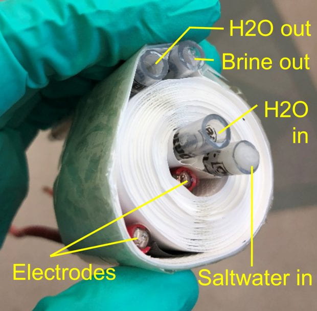
A coiled distillation membrane system for desalinating hypersaline brine. Rolling the system into a coil demonstrated the possibility of adopting a common space-saving, water-filtration format. (Photo by Kuichang Zuo/Rice University)
Click the link to read the article on The Denver Post website (Conrad Swanson). Here’s an excerpt:
The gist: The Pacific Ocean has more than enough water to supplement whatever the Colorado River has lost. But, as it is, ocean water is not safe to drink, nor can it be used on crops. Running ocean water through a desalination plant can filter out its dangerously high salt content, bacteria and other impurities to make it safe for use…
The recently opened PUR Water facility in Oceanside turns blackwater into potable water, or toilet to tap as it was once called, by pumping it into the ground then filtering it through a warehouse full of white filtration tubes. The colored pipes represent the different types of water at different stages. his facility in Oceanside, California turns recycled water into potable water by running it through filtration tubes. TED WOOD
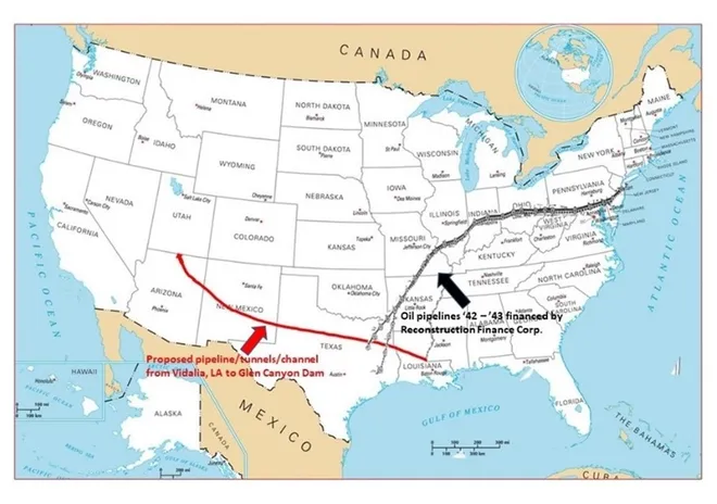
This proposed pipeline divert water from the Atchafalaya River in Louisiana through Louisiana, Texas, New Mexico, Arizona and up to the Glen Canyon Dam. Credit: Don Siefkes
The gist: By spraying a chemical compound — typically silver iodide — into certain types of clouds, seeders can agitate super-chilled water particles inside, causing them to freeze and fall to the ground as snow…
The downtown Denver skyline from Arvada. Photo credit: Allen Best/Big Pivots
The gist: The more people, industries and businesses that call the American West their home, the more water those communities will need. Cities and states can encourage current residents to use less water, especially with aspects like water-dependent lawns. And they can require new homes and businesses to ensure they have a water supply before building…
The gist: State and federal officials could use huge chunks of now-available money to “buy and dry” farmland, farmers could periodically let their fields lay fallow or they can switch to less water-consumptive crops. Likely, the basin needs a combination of all of these combined with efficiency improvements throughout the industry to save water from the irrigating process…
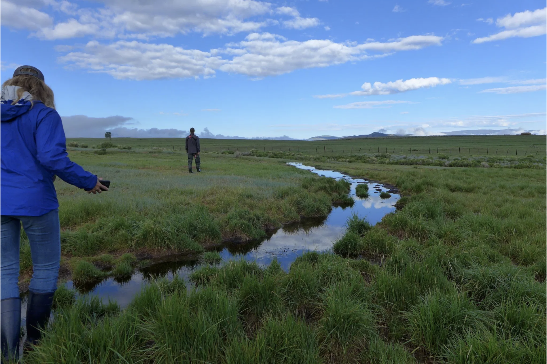
Wildlife biologist Bill Vetter and Western Rivers Regional Program Manager with Audubon Rockies Abby Burk walk along an irrigation ditch in Grand County. An avian monitoring program aims to learn more about how birds use irrigated agriculture.
CREDIT: HEATHER SACKETT/ASPEN JOURNALISM
The gist: By legally cementing the water rights for the tribes depending on the Colorado River, state and federal governments could begin to lease, buy or otherwise compensate the tribes for their water. In addition, this would give the tribes better access to their own water, which they need to drink, farm and develop their communities.
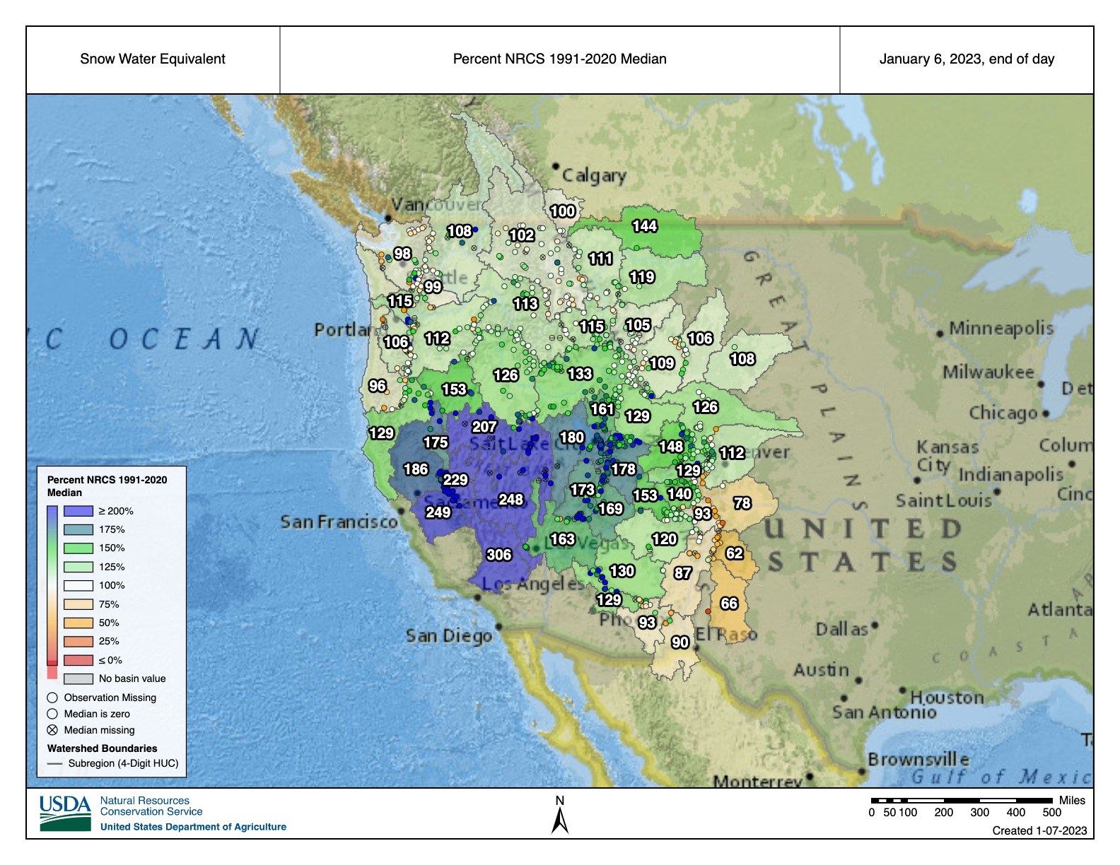
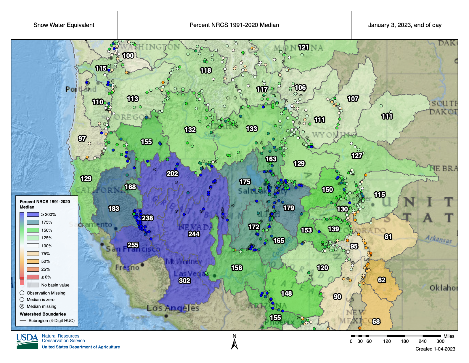
West SWE basin-filled map January 3, 2023 via the NRCS.
Click the link to read the article on the KLAS website (Greg Haas). Here’s an excerpt:
Dec. 27 measurements of 102% snowpack in the region — just above normal — had risen to 142% as of today (Jan. 3) in the Upper Colorado River Basin. That week-to-week change is good news but demonstrates the volatility of snowpack levels. Just as rainfall makes little to no impact on the level of Lake Mead, snowpack levels in early January shouldn’t be seen as a sign that a few snowstorms will erase years of drought, experts say…The “atmospheric river” conditions that are feeding moisture into the Colorado mountains are certainly helping. That pattern was expected to end sometime this week…
Currently, snowpack conditions throughout the basin are above normal. Mountains that feed the headwaters of the Colorado River are at 129% of normal. The highest levels are in Utah, where mountains that feed the Green River are at 180% of normal snowpack and the Lower San Juan region is at 175% of normal…
And climate change’s effects are now being quantified as more data becomes available.
“In effect, temperature is opening up a gap between precipitation and streamflow,” according to Jeff Lukas of the Western Water Assessment, a team of scientists from the University of Colorado, the University of Utah and the University of Wyoming…
“In the past 40 years, a warming trend of about 2 degrees Fahrenheit has discernably impacted basin hydrology. This regional warming, like that at broader scales, has been linked to human causes,” Lukas said in summarizing a study of hydrology in the Colorado River basin released in 2000.
Click the link to read the newsletter on The Land Desk website (Jonathan P. Thompson). Here’s an excerpt:
Aridification Watch
Okay, “aridification” may be the wrong header this time, since the West is getting battered by atmospheric rivers and bomb cyclones and power grid-wrecking snows and winds and rains. It’s record-breaking craziness — at least it seems that way, since we haven’t had much like it in a bit. But is it really all that unusual? Here’s a mini-Data Dump on early winter snowpack levels to help us figure it out:
19: Number of monthly precipitation records broken during the first 28 days of December 2022 in the Western climate region (the final three days aren’t yet recorded in the system).
8.2: Inches of precipitation recorded during a 24-hour period at Sierraville Ranger Station in California on Dec. 2, 2022, shattering the previous all-time record set in 1913.
27: Inches of new snow that fell in the Tahoe City, California, area on Jan. 1, 2023. It contained about 3.33 inches of water. On Dec. 11 the area received 31 inches of snow in one day.
210,000: Approximate number of utility customers who lost power along the West Coast as a result of the late December storms.
30,000: Number of utility customers who lost power in the Northwest after vandals attacked four electrical substations in Washington state on Christmas day.
3: Number of people killed by avalanches so far this season, including two skiers/snowboarders in Colorado and a snowmobiler in Montana.
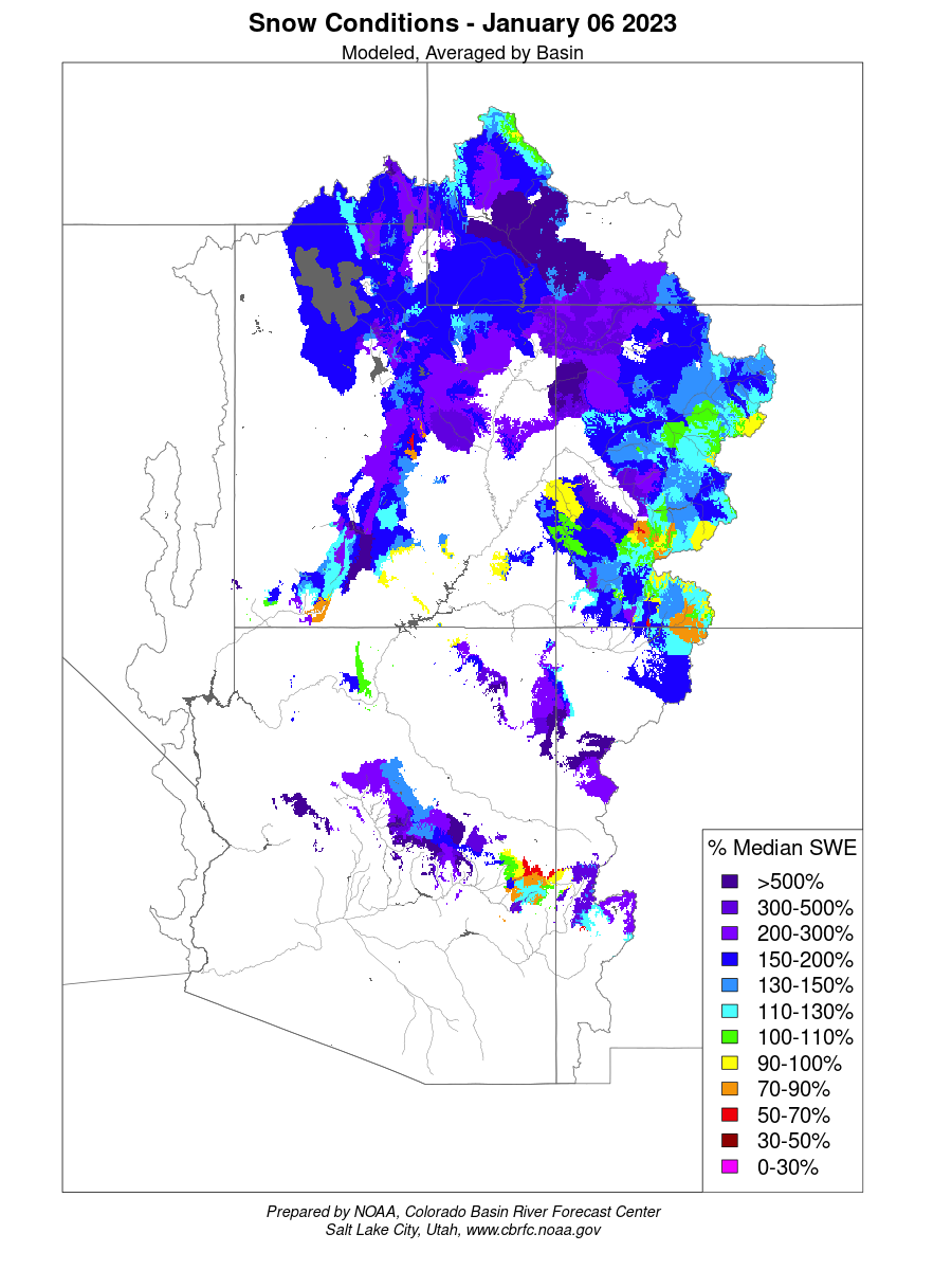
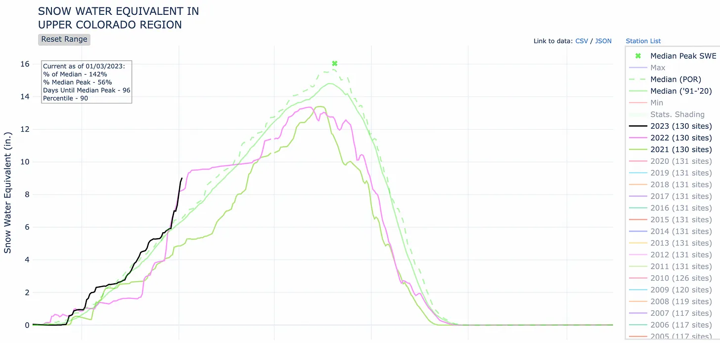
Further inland, the moisture is giving a needed boost to the giant snowpack “reservoir” that feeds the beleaguered Colorado River system. After tracking close to median levels for the first three months of the 2023 water year, this year’s Upper Colorado Basin snowpack shot up to 142% of the Jan. 3 “normal.” It may be a little too early to get excited, though — last year’s snows followed the same early season abundant pattern before dropping off in January.
Zooming in on the San Juan Mountains and Southwest Colorado we see a similar but slightly less wet pattern. Levels are above the median, but still below last year and 2020.
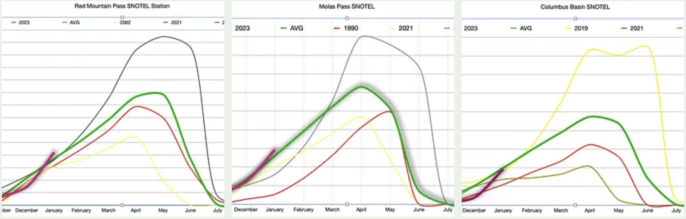
And zooming in even further to our three go-to SNOTEL stations, all located in Southwest Colorado, we find that snowpack levels are about at the average for each station’s period of record (which varies from station to station), but are still tracking ahead of 2019, which turned out to be a BIG snow year.
All of which is to say, it’s too early to really know what winter will bring us. So be sure to enjoy the snow while it’s here!
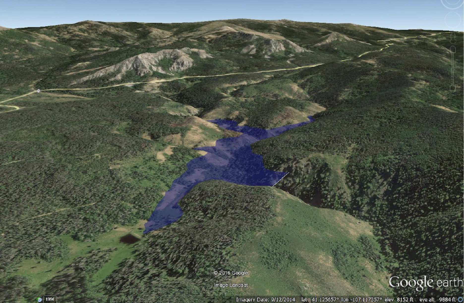
Water developers want to construct a 264-foot high dam on the West Fork of Battle Creek south of Rawlins. This artist’s conception shows in a Google Earth rendition what the reservoir would look like. (Wyoming Water Development Office)
Federal authorities have set a Feb. 13 deadline for comments on a proposal to build a 264-foot-high concrete dam in the Medicine Bow National Forest in Carbon County.
The proposed West Fork Dam and reservoir would impound 6,500 acre-feet of irrigation storage in the Little Snake River Valley and parts of Colorado. Another 1,500 acre-feet would maintain a “minimum bypass flow” into Battle Creek and the Little Snake, Yampa, Green and Colorado Rivers downstream.
Officials announced the deadline in the Federal Register on Dec. 28 where they said they would accept written comments for 45 days. The Natural Resources Conservation Service has scheduled three public meetings Jan. 10-12 in communities in the impacted region.
The meetings are not designed as forums at which officials will accept public comment, Aaron Voos, a spokesman for the Medicine Bow said. Officials will use them to explain plans for construction of the proposed West Fork Dam and reservoir and the parallel Forest Service examination of a land exchange that would enable the project.
Why it matters
The dam would cost some $80 million, according to a 2017 estimate, and the state would pay $73.6 million of that, original plans state. The dam and reservoir would generate an estimated $73.3 million in public benefits such as recreation and fishing, according to developers. Those benefits allow the state to reduce the amount irrigators would have to contribute, according to documents outlining the plan.
The proposal to impound more water in the Colorado River Basin and extract it from waterways for “increased pasture and hay production” comes at a time when seven Western states and Mexico are at odds over who can use what water in the overtaxed system. Even though officials are struggling to maintain water levels in Lake Powell, Wyoming believes it has the right to construct the reservoir and use flows from the basin’s network of waterways.
Who said what:
The Natural Resources Conservation Service, an agency of the U.S. Department of Agriculture, will prepare an environmental impact statement analyzing six alternatives, including no-action and an option that would use “alternate means such as … water conservation projects and habitat improvement projects” to achieve watershed-plan goals.
Updated Colorado River 4-Panel plot thru Water Year 2022 showing reservoirs, flows, temperatures and precipitation. All trends are in the wrong direction. Since original 2017 plot, conditions have deteriorated significantly. Brad Udall via Twitter: https://twitter.com/bradudall/status/1593316262041436160
The cuts that are needed are on an unprecedented scale, and officials will be fighting an uphill battle against a deep, multi-year drought to get them done. State officials tried drastic measures to cut their usage this year, but the river’s continued decline was an alarming reality check…Experts told CNN that even with a good winter and spring runoff season, water managers still need to plan for the worst-case scenario.
“You can’t live with no water in the reservoirs hoping for good years; you need to refill the system,” Eric Kuhn, former manager of the Colorado River Water Conservation District, told CNN. “People realize that you can’t live on the brink of disaster.”
[…]
Anxiety is growing in the West as reservoir levels plummet. Negotiations between the states on voluntary water cuts have been tense and closely watched, particularly between the Lower Basin states of California, Arizona and Nevada. Those talks have stalled amid disagreement on how much water each state should sacrifice and how much money farmers, tribal nations and cities should be paid to reduce their water consumption. State negotiators are themselves waiting for the feds to decide how it will dole out $4 billion in drought relief money, which the Biden administration fronted from the Inflation Reduction Act to essentially pay people to not use water.
“I would not say it has put anything on hold,” Buschatzke told CNN.
Colorado River “Beginnings”. Photo: Brent Gardner-Smith/Aspen Journalism
The outflow at the bottom of Navajo Dam in New Mexico. Photo: Brent Gardner-Smith/Aspen Journalism
From email from Reclamation Susan Novak Behery:
In response to sufficient flows in the critical habitat reach, the Bureau of Reclamation has scheduled a decrease in the release from Navajo Dam from 350 cubic feet per second (cfs) to 300 cfs for Tuesday, January 3rd, at 4:00 AM.
Releases are made for the authorized purposes of the Navajo Unit, and to attempt to maintain a target base flow through the endangered fish critical habitat reach of the San Juan River (Farmington to Lake Powell). The San Juan River Basin Recovery Implementation Program recommends a target base flow of between 500 cfs and 1,000 cfs through the critical habitat area. The target base flow is calculated as the weekly average of gaged flows throughout the critical habitat area from Farmington to Lake Powell.
Click the link to read the article on the Esquire website (Charles P. Pierce). Here’s an excerpt:
Meanwhile, in arctic Canada, the First Nations people who live around North Spirit Lake have been boiling their water for 20 years, and they’re still doing so despite having won a notable court case on the subject a year ago.
“For years, and in some cases decades, Canada has failed to provide safe drinking water to many of its Indigenous communities, including North Spirit Lake, a remote reserve in northwestern Ontario that has been under a boil water advisory nearly continuously since 2001. Decaying infrastructure at water plants and a lack of trained operators has, on many reserves, rendered the treated water undrinkable. Since 1995, more than 250 First Nations have been affected, according to court records. As a result, Indigenous people have fallen ill from gastrointestinal infections, respiratory illnesses and severe rashes, with some ending up hospitalized. Boiling water has become a daily inconvenience, and entire communities, already struggling with chronic financial hardship, must rely on shipments of expensive bottled water.”
So the Native people went to court, and won, and nothing much has changed.
“Last year, Canada’s federal court approved a settlement of a class-action lawsuit filed by three Indigenous communities accusing the government of breaching its legal obligations to First Nations by failing to guarantee access to sanitary drinking water…In the year since the settlement, Canada has spent more than the agreement requires and several First Nations have received new infrastructure, which “represents important progress,” Michael Rosenberg, a lawyer for the First Nations, said in an email. But the government is still a long way from solving the problem. “We’re at a point where the lack of drinkable water on First Nations stands as a really sharp symbol of the failures of the Canadian state,” said Adele Perry, a history professor and director of the Centre for Human Rights Research at the University of Manitoba.”
Just as was the case with the horrors of the residential schools, Canada’s crisis supplying water to its Native peoples presages a similar one in this country, something that the administration is trying to mitigate in advance. But there are complications here that don’t exist around North Spirit Lake. For example, 29 federally recognized tribes depend on the beleaguered Colorado River for their water. Those tribes own the rights to around 20 percent of the water in the Colorado River basin. And this complication has complications.
From the 2018 Tribal Water Study, this graphic shows the location of the 29 federally-recognized tribes in the Colorado River Basin. Map credit: USBR
According to the Community Collaborative Rain Hail and Snow Network (CoCoRaHS) website, sites in Archuleta County received between 2 and 5.5 inches of snowfall over Tuesday night and Wednesday morning. A Dec. 28 report from Wolf Creek Ski Area indicated that, as of about 6 a.m.,Wolf Creek had received 4 inches of snow in the previous 24 hours, bringing the midway snow depth to 43 inches and the year- to-date snowfall total to 95 inches. According to the U.S. Department of Agriculture (USDA) Na- tional Water and Climate Center’s snowpack report, the Wolf Creek summit, at 11,000 feet of elevation, had 10.9 inches of snow water equivalent as of noon on Wednes- day, Dec. 28. The Wolf Creek summit was at 78 percent of the Dec. 28 snowpack median. The San Miguel, Dolores, Ani- mas and San Juan River basins were at 78 percent of the Dec. 28 median in terms of snowpack.
At its Dec. 15 meeting, the Pagosa Area Water and Sanitation District (PAWSD) Board of Directors approved its 2023 budget and a loan agreement for $38,444,000 for the expansion of the Snowball water treatment plant. The board also discussed rate increases and potential additional fees to fund the plant’s construction…
The group then circled back to discuss the rate increases further, with [Justin] Ramsey indicating that the staff recommendation is to implement the 6 percent water rate increase in 2023, as recommended by the 2018 study, move up the 2.5 percent wastewater rate increase in the 2018 study up a year to 2023 and hold off on any other rate increases for the Snowball plant until the new rate study is finalized.
On Thursday, Dec. 14, the San Juan Water Conservancy District (SJWCD) held a meeting where it conducted a public hearing and discussed its 2023 budget and discussed the possibility of a public take-out point along the San Juan River, among other items.
Engineering/Studies/Surveys appeared as the largest line-item expenditure in the proposed 2023 budget, amounting to $45,000. And since the board did not entertain reducing this item, it will “pull $20,000 out of sasvings” to pay for it and also maintain a zero deficit, explained Tedder.
Public access to the San JuanRiver
At the same meeting, the board heard about efforts to have public access to the river on land owned by the SJWCD and Pagosa Area Water and Sanitation District (PAWSD). [Al] Pfister, and possibly a representative from PAWSD, will be sitting down with representatives from Colorado Parks and Wildlife (CPW ), mainly to discuss fishery issues and potential funding, according to Pfister.
“This is basically being done under the watershed enhancement project,” Pfister said.
San Juan Mountains December 19, 2016. Photo credit: Allen Best
The Dolores River, below Slickrock, and above Bedrock. The Dolores River Canyon is included in a proposed National Conservation Area. Photo: Brent Gardner-Smith/Aspen Journalism.
Click the link to read the article on the KSJD website (Gavin McGough). Here’s an excerpt:
The Dolores River starts high in the San Juans southwest of Telluride, passes through Dolores, Colorado, where it fills the Reservoir at McPhee Dam. From then on it trickles north through hundreds of miles of desert, meeting the San Miguel and feeding eventually into the Colorado River. Those who have boated it say it’s a river like no other.
“You start below the dam and you head into the Ponderosa Gorge with these big canyon walls and amazing majestic Ponderosa Pines, and you start to see more and more of this red rock coming out,” said Amber Clark, director of Dolores River Boating Advocates (DRBA) which promotes stewardship and recreation along the river.
“Then you transition down into less trees and more red rock canyon walls, and the Wilderness Study Area, and at different places it opens up more, and it’s kind of this ever-changing landscape, but the majesty of it never diminishes,” she said…
The DRBA is one of dozens of stakeholders who have been working to protect the Dolores as a National Conservation Area, or an NCA. Some rivers are protected by Congress under The Wild and Scenic Rivers Act, but protection as an NCA is less controversial, especially amongst agricultural interests. Al Heaton, a cattle rancher in Dolores, is involved in the conservation effort.
“Wild and Scenic comes with some rules and regulations, some laws, that are pretty dramatic and would affect a lot of things, private property and things down the river,” said Heaton.
“Of course, grazing could continue in a Wild and Scenic setting but it could also be restricted, so I felt there had to be a better way.”
Time has not been kind to our rivers. For centuries, humans have diminished, degraded and simplified rivers around the world, creating unhealthy waterways that have lost ecological value.
The good news is that our collective understanding of how to restore rivers is improving, with a greater focus on using natural systems to meet society’s needs while also protecting the environment. With nature-based management, we have an opportunity to rebuild rivers with the space and freedom they need to thrive. In turn, these healthier rivers lead to healthier communities and a healthier planet.
I spoke with Peter Skidmore, senior program officer with the foundation’s Colorado River initiative, about how restoring river health through natural processes can help us in the battle against climate change. He is the co-author of a recent article in the journal Anthropocene exploring the issue.
Can you describe some of the ways that rivers have been degraded over the past several hundred years?
As a society, we have relegated rivers and streams to constrained channels. These simplified and stabilized channels have lost a lot of their freedom, complexity and biodiversity. Starting in the 19th century, the extermination of beavers fundamentally changed the character of streams as dams were removed and riparian wetlands disappeared. With development in their valley bottoms, rivers have also lost the space to run free, flood, erode and deposit soil. The construction of dams and diversions have further constricted river flows.
What are we learning about emerging opportunities to restore the health of rivers so they can provide critical ecosystem services?
There has been a lot of hard work done to restore river health over the past few decades, but we’ve fallen short in addressing the challenge at a scale to have lasting impact. Over this time, we learned a lot about the potential of “natural infrastructure” to better manage rivers and restore their health through dynamic, natural processes. That can mean removing constraints wherever possible – setting levees back, concentrating infrastructure at a few pinch points, reconnecting rivers to their floodplains and renewing native vegetation.
Peter Skidmore is a senior program officer in the Environment Program focusing on the Colorado River initiative. Photo credit: Walton Family Foundation
Is there an example of how natural infrastructure can restore river health and improve climate resiliency?
One way is by promoting the return of beavers and beaver-related wetlands that reintroduce much-needed complexity into river systems. Messy rivers and streams – with features like braided and irregular channels, wetlands, eroding banks and gravel bars – are more diverse, dynamic and healthy. A success story is Bridge Creek, in Oregon, where the installation of beaver-inspired natural dams led to the expansion of beaver activity. These structures create a virtuous cycle of restoration that slows down water flow, revives mountain meadows and recreate stream meanders and wetlands that are ultimately maintained forever by beavers. They help maintain and retain groundwater, provide natural firebreaks and refuge for wildlife, and can alleviate the sedimentation impacts of post-fire flooding. Since 2005, Bridge Creek has had a dramatic increase in aquatic habitat and native fish populations. In addition to those fish and wildlife benefits, scientists are also finding that this kind of low-cost, low-tech restoration helps with carbon sequestration, nutrient capture and moderation of stream flow and temperature – critical ecosystems services in the face of drought and climate change.
A beaver dam on the Gunnison River. Beaver dams serve as inspiration for restoration projects that re-establish small, leaky and temporary dams in degraded stream systems. Photo: Brent Gardner-Smith/Aspen Journalism
What potential does this kind of restoration have to increase climate resiliency if done on large scale?
River ecosystems have a tremendous capacity for passive restoration if given the freedom space for dynamic interactions between the channel and the floodplain. They can literally heal themselves, often more quickly and effectively than we can. Just like humans need exercise to stay healthy, rivers also need that exercise. They need the space to move around. That’s important because, right now, ongoing development is exacerbating the impacts of a warming climate and straining the capacity of aging, expensive gray infrastructure to provide water security and protection from floods and drought. Natural infrastructure holds the potential to be a cost-effective and self-sustaining way to improve environmental health. It can be a critical component in a mix of solutions to the social and ecological challenges posed by climate change.
The good news is that if we give the incised streams some room, they can be restored to their healthy state and bring us the fire protection and water storage benefits that we really need. Graphic credit: SLO Beaver Brigade: http://www.slobeaverbrigade.com/2021/06/01/something-to-chew-on/
How is the foundation supporting natural infrastructure in the Colorado River basin?
The foundation’s five-year Environment program strategy increases our efforts to improve river and watershed health by working to improve public policy so it promotes nature-based solutions, and leveraging funding to implement them on a larger scale. We’re working with partners to test and increase the use of nature-based solutions that improve water security for farms and cities and also provide environmental benefits. We’re investing in beaver-related restoration that re-establishes wetlands and begins to restore degraded stream systems. And we’ve initiated an effort to identify and map changes in vegetated wetlands and beaver ponds throughout the basin as a way to measure progress and assess the potential of this work to provide system-wide benefit for the Colorado River.
Colorado River “Beginnings”. Photo: Brent Gardner-Smith/Aspen Journalism
The Upper Colorado River Commission plans to revive a program that pays irrigators and other valid rights holders to voluntarily leave water in streams that feed the beleaguered Colorado River.
The System Conservation Pilot Program is one strategy among a handful that Upper Colorado River Basin states — Wyoming, Colorado, Utah and New Mexico — have offered to help satisfy their role in meeting a challenge by federal officials to conserve 2 million to 4 million acre-feet of water system-wide in 2023.
“The goal is to have water conservation projects underway in April 2023 to reduce consumptive uses in the Upper Basin Colorado River system,” the UCRC stated in a Dec. 14 press release. More “durable” and “longer-term” solutions are still needed, however, the UCRC said. “The SCPP is a significant step to begin to partially mitigate the water supply crisis in the Upper Colorado River Basin brought on by a drier climate and depleted storage.”
The SCPP was initially implemented from 2015 through 2018 using funds from Lower Colorado River Basin stakeholders, including large municipalities such as Las Vegas. This time around, the UCRC proposes to instead use $125 million from the Inflation Reduction Act — an appropriation that backers hope Congress will approve in a spending bill.
Water users have only until Feb. 1 to submit proposals in response to a call for applications that was issued Dec. 14.
Water users are urgently trying to keep Lake Powell on the Utah-Arizona border from dropping to a point where Glen Canyon Dam can no longer generate electricity. (Source: Bureau of Reclamation)
The UCRC scrambled in recent months to relaunch the SCPP water conservation program under pressure to lay the groundwork for both short- and long-term water savings amidst a growing crisis along the Colorado River. The river system serves some 40 million people in seven western states and Mexico.
The 22-year “megadrought” that has parched much of the American southwest — combined with growing demands on the river — has drained Lake Powell and Lake Mead to their lowest levels in history and shows no signs of abating, according to the federal Bureau of Reclamation.
The ongoing crisis, if drought conditions continue, could result in mandated water curtailments in Wyoming by 2028, according to the Wyoming State Engineer’s Office. Municipalities, including Cheyenne, Green River and Rock Springs, are among the most vulnerable because — generally — they hold junior water rights that, under the Colorado River Compact and Wyoming water law, would be among the first to be restricted under a curtailment. About one-fifth of Wyoming’s population relies on domestic water supplies subject to a curtailment under the Colorado River Compact.
Compensated conservation
Despite the quick turnaround to attract volunteer projects under the revived SCPP, water officials and conservation advocates in Wyoming believe there’s growing interest. Conservation groups such as Trout Unlimited played an integral role in the first iteration of the SCPP, seeing an opportunity to promote water conservation measures that also benefit fisheries and the general biological health of waterways by keeping more water in streams and rivers late in the summer.
Wyoming Trout Unlimited Water & Habitat Program Director Cory Toye helped introduce many agricultural water users to the SCPP in the first go-round, and that work has resumed in recent months, he said.
“It’s certainly on people’s minds,” Toye told WyoFile. “For the most part, it still makes economic sense for a lot of [irrigated ag] operations.”
Participation among Wyoming water users increased incrementally over the first four years of the program. All told, the SCPP in Wyoming saved a total 23,886 acre-feet at 26 project sites. It cost $4,079,233 — about $171 per-acre foot, according to a report by the upper basin commission.
For now, the commission envisions a “fixed term” compensation of $150 per acre-foot under the SCPP in 2023, although it may consider higher rates based on circumstances, according to the agency’s request for proposals.
Dipping toes
Eric Barnes, an irrigator on Fontenelle Creek — a tributary of the Green River in western Wyoming — was among the first SCPP participants in the state, and he’s eager to enroll in the program in 2023, he said. Barnes irrigated as usual in the spring to grow an early season crop, he said, then curtailed irrigation later in the summer — a water conservation practice known as “split season deficit irrigation.” All 26 projects in Wyoming during the first four years of the program fell under this category.
“It was beneficial for me,” Barnes said. “I was able to take advantage of the water early in the season and then shut [irrigation headgates] off and get paid for [conserving water] in the same year.”
A pump pulls water from the Green River at a Sweetwater County-managed recreation area Sept. 27, 2022. (Dustin Bleizeffer/WyoFile)
The practice — at least on Fontenelle Creek, Barnes said — left more water in the creek to support the trout fishery; a benefit to the local recreation economy and a priority for groups like Trout Unlimited.
“It was a good way to help people understand what life may look like with less water and what diversifying [irrigation] operations might look like,” Toye said. “And the scale of the projects went from scattershot those first couple of years to tying entire tributaries together.”
For now, the program makes sense for a lot of Wyoming ag irrigators subject to the Colorado River Compact, according to Toye, particularly in the upper reaches of the Green River and its tributaries. Although Wyoming and its fellow upper Colorado River basin states are eager to revive the program, it will soon evolve and be replaced by a larger conservation program with more sophisticated water-accounting protocols that are recognized by stakeholders throughout the system.
Those changes may entice ag irrigators like Barnes to take on water conservation strategies beyond simply foregoing a second round of summer irrigation, Toye said. However, he added, the program isn’t intended to shrink or replace ag production.
“The goal is to make sure people can do as much as they have historically with less water, or at least be prepared to do that,” Toye said. “So the intent is to explore different irrigation patterns and perhaps identify places where efficiencies can occur.”
“One of the big problems with bringing water from somewhere else is a false sense of security. When we live long distances from our water, we may not understand the limits of that supply or ecosystem- so conservation is less likely” — Abby Burk
Reprinted with permisssion from Don Siefkes:
Mike Wade, “Imperial Valley can’t sustain another water cut,” Dec. 14, is absolutely right. However, if we can’t get new water to the Colorado River, and even though conservation is important, no amount of conservation is going to fix this problem.
Here’s one solution to avoid the looming disaster. The National Infrastructure Bank (NIB) set out in House Resolution 3339 would provide $5 trillion in low-cost loans for a broad range of public infrastructure projects – including massive water systems – without the need for increasing taxes or any deficit budget spending. This bill is modeled on the successful Reconstruction Finance Corporation (RFC) started by President Herbert Hoover and used by President Franklin D. Roosevelt to build Hoover Dam and bring water and electricity to the Southwest.
Credit: Dan Swenson
The NIB is prepared to invest up to $400 billion to bring new water to the Colorado River and the Southwest. One possibility would be to divert water from the Atchafalaya River in Louisiana through Louisiana, Texas, New Mexico, Arizona and up to the Glen Canyon Dam.
In this proposal, no water would be taken from the main channel of the Mississippi. As of Dec. 19, 1.43 million gals/sec of Atchafalaya River water was simply going into the Gulf of Mexico without producing electricity or supporting commercial shipping. Taking just 100,000 gals/sec (7%) of this water would fill Lakes Powell and Mead to 50% capacity in one year and 9 months. The project would save on construction costs by using an existing facility – the Old River Control Complex just south of Vidalia, Louisiana, where the Army Corps of Engineers diverts 30% of the downflow of the Mississippi to prevent flooding in New Orleans.
This undertaking would build a 1,400 mile series of pipelines, open channels, tunnels and pumping stations (similar to the California, Los Angeles, Colorado River Aqueducts and the Central Arizona Project). It could be built in a year, along interstate highway rights-of-way, using huge earth-moving machines like those employed in Holland for their canal systems.
There is historical precedent for building systems like this project with deliberate, urgent, speed. In less than a year between 1942 and 1943, the RFC financed and built two pipelines of similar length, 1,200 and 1,400 miles, to carry crude oil from Texas oil fields to the East Coast. These pipelines rescued the entire East Coast industrial oil refining system and won World War II for the Allies.
This proposed pipeline divert water from the Atchafalaya River in Louisiana through Louisiana, Texas, New Mexico, Arizona and up to the Glen Canyon Dam. Credit: Don Siefkes
Such a water aqueduct system might cost on the order of $14 billion-23 billion, a small amount for a $5 trillion bank and also small compared to cutting off water supplies to farmers in the Southwest who produce $39 billion worth of our annual food supply. Without new water in the Colorado, food prices will skyrocket more than they already have, and we will all needlessly suffer. It is also unthinkable to allow water levels in Lakes Mead and Powell to fall to the point where the dams can no longer generate electricity or provide drinking water.
We don’t think anything about pumping crude oil and gasoline through 190,000 miles of U.S. pipelines from areas that have oil and gasoline to areas that don’t. We certainly can do the same with water.
Alphecca Muttardy is a Macroeconomist with the Coalition for a National Infrastructure Bank (NIBCoalition.com), and 25 year veteran of the International Monetary Fund. Don Siefkes is an MIT-trained chemical engineer who represents the Coalition for the NIB in the San Francisco Bay Area. Their emails are, respectively, amuttardy@gmail.com and donsiefkes@aol.com.
The Colorado River is a critical water resource in the southwestern United States, supplying drinking water for 40 million people in the region and water for irrigation of 2.2 million hectares of land. Extended drought in the Upper Colorado River Basin (UCOL) and the prospect of a warmer climate in the future pose water availability challenges for those charged with managing the river. Limited water availability in the future also may negatively affect aquatic ecosystems and wildlife that depend upon them. Water availability components of special importance in the UCOL include streamflow, salinity in groundwater and surface water, groundwater levels and storage, and the role of snow in the UCOL water cycle. This manuscript provides a review of current “state of the science” for these UCOL water availability components with a focus on identifying gaps in data, modeling, and trends in the basin. Trends provide context for evaluations of current conditions and motivation for further investigation and modeling, models allow for investigation of processes and projections of future water availability, and data support both efforts. Information summarized in this manuscript will be valuable in planning integrated assessments of water availability in the UCOL.
Wyoming moved to expedite the construction of a 280-foot-high concrete dam in the Medicine Bow National Forest last month by proposing a 6,282-acre land exchange.
The state wants 1,762 acres of federal property for a dam and reservoir on the West Fork of Battle Creek in the Sierra Madre Mountains, according to a Nov. 30 letter and map from Jenifer Scoggin, the director of Wyoming’s Office of State Lands and Investments. In exchange, Wyoming would transfer ownership of up to 4,520 acres of state school trust lands to the federal government. That school trust land lies inside the boundaries of the Medicine Bow-Routt National Forest.
The Medicine-Bow announced the application in a press release setting three public meetings that will be held on the evenings of Jan. 10, 11 and 12 in Craig, Colorado, Baggs and Saratoga respectively. The dam would be built on a tributary of the Little Snake River that flows into the Yampa, Green and Colorado Rivers.
“Conveying this parcel out of Federal ownership would eliminate the need for a USFS special use permit for the reservoir as well as provide for efficient management of the reservoir and surrounding lands,” states the 19-page notice of intent and proposal, which Scoggin sent to Brush Creek/Hayden District Ranger Jason Armbruster in Saratoga. Wyoming needs the federal property to construct the reservoir and meet “fiduciary obligations to produce income to support public schools and other state institutions,” the letter reads.
WyoFile obtained a copy of Scoggin’s letter, the proposal and map Tuesday from deputy director Jason Crowder.
The state Board of Land Commissioners last summer conceptually approved investigating a land exchange that would have covered some 24,000 acres. That approval allowed state officials to offer a smaller exchange in an effort to accelerate the West Fork Dam and reservoir project, Crowder said.
Smaller would be faster
“[T]he reality of getting something like that [larger exchange] done isn’t all that hot,” Crowder said. The Forest Service would have to examine a larger exchange through the National Environmental Policy Act process, which would take considerably longer than what’s being proposed, he said.
“Something that large isn’t anything that could get done in a timely fashion,” Crowder said. “It’s probable that a larger exchange … wouldn’t be feasible or successful in the near term.”
Instead, an exchange “that was more narrowly focused [on the land] needed for the reservoir construction and implementation would be OK,” he said.
Instead of writing an environmental impact statement that’s common for major proposals under NEPA, the Forest Service will instead conduct a “feasibility analysis/study,” Medicine Bow officials said in a statement. “The resulting product is referred to as a Public Interest Determination,” that would approve or reject the exchange, the Forest Service news release states.
The Forest Service study will focus on the future use and management of the lands and the effect of the exchange on the lands that adjoin them, the Medicine Bow release said.
Estimated in 2017 to cost $80 million, the proposed West Fork Reservoir would serve 67 to 100 irrigators. A 130-acre reservoir would hold 10,000 acre feet of water primarily for irrigation. The project is sponsored by: Savery-Little Snake Conservancy District and Pothook Conservancy in Colorado, the Forest Service said.
The proposed reservoir would impound and divert water from the troubled Colorado River Basin where residents in seven states and Mexico are at odds over how to use dwindling flows.
“It is important to note that the Forest Service has not yet determined if this is a feasible exchange, nor has the agency agreed to initiate it,” the Medicine Bow statement reads.
The Jan. 10 meeting in Craig will be from 5-7 p.m. at Colorado Northwest Community College. A virtual option will be available through the Forest Service website.
The meeting Jan. 11 in Baggs will be held from 6:30-8:30 p.m. at the Valley Community Center. The Saratoga meeting the following day will be from 5:30-7:30 at the Platte Valley Community Center.Land exchange proposal details will be available the week of the public meetings on the Forest’s project website, the Medicine Bow announcement stated.
Water users are urgently trying to keep Lake Powell on the Utah-Arizona border from dropping to a point where Glen Canyon Dam can no longer generate electricity. (Source: Bureau of Reclamation)
Nevada water managers have submitted a plan for cutting diversions by 500,000 acre-feet in a last-ditch effort to shore up flows on the Colorado River before low water levels cause critical problems at Glen Canyon and Hoover dams. But the Silver State’s plan targets cuts in Utah and the river’s other Upper Basin states, not in Nevada, whose leaders contend it already is doing what it can to reduce reliance on the depleted river system that provides water to 40 million in the West.
“It is well past time to prohibit the inefficient delivery, application, or use of water within all sectors and by all users; there simply is no water in the Colorado River System left to waste and each industrial, municipal, and agricultural user should be held to the highest industry standards in handling, using, and disposing of water,” states a Dec. 20 letter the Colorado River Commission of Nevada sent to the Interior Department. “It is critical that Reclamation pursue all options that will help reduce consumptive uses in the Basin and provide water supply reliability.”
[,,,]
One option Nevada offers is for Utah, Colorado, New Mexico and Wyoming to accept substantial cuts in the amount of river they tap to ensure enough water reaches Lake Powell to keep Glen Canyon Dam’s hydropower turbines spinning and Lake Powell functioning as a reservoir…The proposal comes in the form of Nevada’s official comments to the supplemental environmental impact statement the Bureau of Reclamation is preparing for proposed changes to the operations of the drought-depleted reservoirs. One of three Lower Basin states, Nevada called on the Upper Basin states to reduce their withdrawals by a combined 500,000 acre-feet if Lake Powell’s level is projected to drop below 3,550 feet above sea level at the start of the coming calendar year…Today, the lake’s level is already far below than that, at 3,525.7 feet, just 35 feet above the point at which Glen Canyon Dam’s turbines would be damaged if water passes through the penstocks.
Lake Powell key elevations. Credit: Reclamation
“The reason [The Upper Colorado River Commision’s] five-point plan doesn’t have any specific numbers is because we don’t know what’s ahead of us. We don’t know whether the runoff is going to be 7 million acre-feet or 20 million acre-feet,” Shawcroft said. “The real challenge is the hydrology. But we know for a fact that that we’re not going to be able to continue operating the river like we always have. The majority of the water gets used in the lower basin states, but does that mean that Upper [Basin] states are off the hook? I don’t think they are.”
Colorado Water Conservation Board Executive Director and commissioner to the Upper Colorado River Commission Becky Mitchell, center, speaks on a panel with representatives of each of the seven basin states at the annual Colorado River Water Users Association conference in Las Vegas Thursday. The UCRC released additional details of a water conservation program at the CRWUA2022 Conference. CREDIT: HEATHER SACKETT/ASPEN JOURNALISM
Click the link to read the article on the KJZZ websits (Ron Dungan). Here’s an excerpt:
Colorado River Basin states recently gathered in Las Vegas for their annual water users convention. The states are trying to figure out how to get by with less water. The conference focused on a variety of topics, such as new technology, conservation and funding that will guide water users into the next century. But federal water managers say that new conservation measures need to be put in place or they will impose cuts.
Fountains shoot water from the Colorado River into the air outside of Caesar’s Palace in Las Vegas Friday. The resort hosts the annual Colorado River Water Users Association conference. CREDIT: HEATHER SACKETT/ASPEN JOURNALISM
Click the link to read the latest edition of The Runoff newsletter from the Aspen Journalism website:
Cities versus agriculture
Some water managers at CRWUA acknowledged a truth that is widely known but rarely stated so candidly: As the Colorado River crisis deepens, water to cities will not be cut off in favor of continuing to grow hay in the desert, no matter what the law of the river — which grants the most powerful water rights to the mostly agricultural users who got here first — says.
“If the literal enforcement of the law is that 27 million Americans don’t have water, those laws will not be enforced,” said John Entsminger, general manager of the Southern Nevada Water Authority.
The wisdom of building mega-cities in arid regions aside, the fact is that Denver, Phoenix, Las Vegas and L.A. exist now and rely on the Colorado River. And denying people water at their taps would be a public health catastrophe and moral failure.
“People migrate toward opportunity and you can’t stop it only at great moral cost,” said Kathryn Sorenson, a professor at Arizona State University and former director of Phoenix Water Services. “The cities have an obligation to provide water to the people who arrived.”
Water supplies are shrinking throughout the Southwest, from the Rocky Mountains to California, with the flow of the Colorado River declining and groundwater levels dropping in many areas. The mounting strains on the region’s water supplies are bringing new questions about the unrestrained growth of sprawling suburbs. [Kathleen] Ferris, a researcher at Arizona State University’s Kyl Center for Water Policy, is convinced that growth is surpassing the water limits in parts of Arizona, and she worries that the development boom is on a collision course with the aridification of the Southwest and the finite supply of groundwater that can be pumped from desert aquifers.
For decades, Arizona’s cities and suburbs have been among the fastest growing in the country. In most areas, water scarcity has yet to substantially slow the march of development. But as drought, climate change and the chronic overuse of water drain the Colorado River’s reservoirs, federal authorities are demanding the largest reduction ever in water diversions in an effort to avoid “dead pool” — the point at which reservoir levels fall so low that water stops flowing downriver. Already, Arizona is being forced to take 21% less water from the Colorado River, and larger cuts will be needed as the crisis deepens…
To deal with those reductions and access other supplies to serve growth, the state is turning more heavily to its underground aquifers. As new subdivisions continue to spring up, workers are busy drilling new wells. Ferris and others warn, however, that allowing development reliant solely on groundwater is unsustainable, and that the solution should be to curb growth in areas without sufficient water.
“What we’re going to see is more and more pressure on groundwater,” Ferris said. “And what will happen to our groundwater then?”
“We pray for the rains to come, for the snow to fall, for moisture in the earth. Not just for the Hopi, but for everybody. For every living thing that’s out there.” – Dennis Hopper, Hopi Elder
The Green and Colorado river systems form the backbone of the American West. Once spanning a 1,450-mile journey from the Rocky Mountains to the Gulf of California, today, none of the sediment-rich water reaches the Pacific Ocean. Instead, its water lies stymied in reservoirs and siphoned off to feed and nurture 40 million people from Salt Lake to Los Angeles.
One hundred and fifty years after John Wesley Powell’s historic descent of the Green and Colorado rivers, an unlikely crew of scientists, artists, educators, and river lovers repeated his journey on a trip that was simultaneously a celebration of modern river life and a critical look at how we interpret the Colorado River’s history and use its waters.
As the demand we place on the water of the Colorado continues to exceed its supply, we are forced to face uncomfortable truths about decisions made in our past. And we are reminded that the way we think about water—and all those dependent upon it—needs to shift if we want things to change for our future.
“Water is a life force for all of us. It has a spiritual and physical being to it that deserves respect. It’s not something that you take for granted.” – Lyle Balenquah, Hopi archaeologist
Map of the Colorado River drainage basin, created using USGS data. By Shannon1 Creative Commons Attribution-Share Alike 4.0
Known for its breathtaking scenery, the Dominguez-Escalante National Conservation Area is a fine example of the spectacular canyon country of Colorado’s Uncompahgre Plateau. Red-rock canyons and sandstone bluffs hold geological and paleontological resources spanning 600 million years, as well as many cultural and historic sites. The Ute Tribes today consider these pinyon-juniper–covered lands an important connection to their ancestral past. The Escalante, Cottonwood, Little Dominguez and Big Dominguez Creeks cascade through sandstone canyon walls that drain the eastern Uncompahgre Plateau. Unaweep Canyon on the northern boundary of the NCA contains globally significant geological resources. Nearly 30 miles (48 km) of the Gunnison River flow through the Dominguez-Escalante NCA, supporting fish, wildlife and recreational resources. The Old Spanish National Historic Trail, a 19th Century land trade route, also passes through it. A variety of wildlife call the area home, including desert bighorn sheep, mule deer, golden eagle, turkey, elk, mountain lion, black bear, and the collared lizard. There are 115 miles (185 km) of streams and rivers in the NCA, and there is habitat suitable for 52 protected species of animals and plants. By Bob Wick; Bureau of Land Management – Dominguez-Escalante NCA, Public Domain, https://commons.wikimedia.org/w/index.php?curid=42092807
by Abrahm Lustgarten
ProPublica is a Pulitzer Prize-winning investigative newsroom. Sign up for The Big Story newsletter to receive stories like this one in your inbox.
On a crisp day this fall I drove southeast from Grand Junction, Colorado, into the Uncompahgre Valley, a rich basin of row crops and hayfields. A snow line hung like a bowl cut around the upper cliffs of the Grand Mesa, while in the valley some farmers were taking their last deliveries of water, sowing winter wheat and onions. I turned south at the farm town of Delta onto Route 348, a shoulder-less two-lane road lined with irrigation ditches and dent corn still hanging crisp on their browned stalks. The road crossed the Uncompahgre River, and it was thin, nearly dry.
The Uncompahgre Valley, stretching 34 miles from Delta through the town of Montrose, is, and always has been, an arid place. Most of the water comes from the Gunnison River, a major tributary of the Colorado, which courses out of the peaks of the Elk Range through the cavernous and sun-starved depths of the Black Canyon, one rocky and inaccessible valley to the east. In 1903, the federal government backed a plan hatched by Uncompahgre farmers to breach the ridge with an enormous tunnel and then in the 1960s to build one of Colorado’s largest reservoirs above the Black Canyon called Blue Mesa. Now that tunnel feeds a neural system of water: 782 miles worth of successively smaller canals and then dirt ditches, laterals and drains that turn 83,000 Western Colorado acres into farmland. Today, the farm association in this valley is one of the largest single users of Colorado River water outside of California.
I came to this place because the Colorado River system is in a state of collapse. It is a collapse hastened by climate change but also a crisis of management. In 1922, the seven states in the river basin signed a compact splitting the Colorado equally between its upper and lower halves; later, they promised additional water to Mexico, too. Near the middle, they put Lake Powell, a reserve for the northern states, and Lake Mead, a storage node for the south. Over time, as an overheating environment has collided with overuse, the lower half — primarily Arizona and California — has taken its water as if everything were normal, straining both the logic and the legal interpretations of the compact. They have also drawn extra releases from Lake Powell, effectively borrowing straight out of whatever meager reserves the Upper Basin has managed to save there.
This much has become a matter of great, vitriolic dispute. What is undeniable is that the river flows as a much-diminished version of its historical might. When the original compact gave each half the rights to 7.5 million acre-feet of water, the river is estimated to have flowed with as much as 18 million acre-feet each year. Over the 20th century, it averaged closer to 15. Over the past two decades, the flow has dropped to a little more than 12. In recent years, it has trickled at times with as little as 8.5. All the while the Lower Basin deliveries have remained roughly the same. And those reservoirs? They are fast becoming obsolete. Now the states must finally face the consequential question of which regions will make their sacrifice first. There are few places that reveal how difficult it will be to arrive at an answer than the Western Slope of Colorado.
In Montrose, I found the manager of the Uncompahgre Valley Water Users Association, Steve Pope, in his office atop the squeaky stairs of the same Foursquare that the group had built at the turn of the last century. Pope, bald, with a trimmed white beard, sat amid stacks of plat maps and paper diagrams of the canals, surrounded by LCD screens with spreadsheets marking volumes of water and their destinations. On the wall, a historic map showed the farms, wedged between the Uncompahgre River and where it joins the Gunnison in Delta, before descending to their confluence with the Colorado in Grand Junction. “I’m sorry for the mess,” he said, plowing loose papers aside.
Colorado Rivers. Credit: Geology.com
What Pope wanted to impress upon me most despite the enormousness of the infrastructure all around the valley was that in the Upper Basin of the Colorado River system, there are no mammoth dams that can simply be opened to meter out a steady release of water. Here, only natural precipitation and temperature dictate how much is available. Conservation isn’t a management decision, he said. It was forced upon them by the hydrological conditions of the moment. The average amount of water flowing in the system has dropped by nearly 20%. The snowpack melts and evaporates faster than it used to, and the rainfall is unpredictable. In fact, the Colorado River District, an influential water conservancy for the western part of the state, had described its negotiating position with the Lower Basin states by claiming Colorado has already conserved about 28% of its water by making do with the recent conditions brought by drought.
You get what you get, Pope tells me, and for 15 of the past 20 years, unlike the farmers in California and Arizona, the people in this valley have gotten less than what they are due. “We don’t have that luxury of just making a phone call and having water show up,” he said, not veiling his contempt for the Lower Basin states’ reliance on lakes Mead and Powell. “We’ve not been insulated from this climate change by having a big reservoir above our heads.”
He didn’t have to point further back than the previous winter. In 2021, the rain and snow fell heavily across the Rocky Mountains and the plateau of the Grand Mesa, almost as if it were normal times. Precipitation was 80% of average — not bad in the midst of an epochal drought. But little made it into the Colorado River. Instead, soils parched by the lack of rain and rising temperatures soaked up every ounce of moisture. By the time water reached the rivers around Montrose and then the gauges above Lake Powell, the flow was less than 30% of normal. The Upper Basin states used just 3.5 million acre-feet last year, less than half their legal right under the 1922 compact. The Lower Basin states took nearly their full amount, 7 million acre-feet.
Colorado River Basin Plumbing. Credit: Lester Doré/Mary Moran via Dustin Mulvaney and Twitter
All of this matters now not just because the river, an unwieldy network of human-controlled plumbing, is approaching a threshold where it could become inoperable, but because much of the recent legal basis for the system is about to dissolve. In 2026, the Interim Guidelines the states rely on, a Drought Contingency Plan and agreements with Mexico will all expire. At the very least, this will require new agreements. It also demands a new way of thinking that matches the reality of the heating climate and the scale of human need. But before that can happen, the states will need to restore something that has become even more scarce than the water: trust.
The northern states see California and Arizona reveling in profligate use, made possible by the anachronistic rules of the compact that effectively promise them water when others have none. It’s enabled by the mechanistic controls at the Hoover Dam, which releases the same steady flow no matter how little snow falls across the Rocky Mountains. California flood-irrigates alfalfa crops destined for cattle markets in the Middle East, while Arizona takes water it does not need and pumps it underground to build up its own reserves. In 2018, an Arizona water agency admitted it was gaming the timing of its orders to avoid rations from the river (though it characterized the moves as smart use of the rules). In 2021, in a sign of the growing wariness, at least one Colorado water official alleged California was repeating the scheme. California water officials say this is a misunderstanding. Yet to this day, because California holds the most senior legal rights on the river, the state has avoided having a single gallon of reductions imposed on it.
Updated Colorado River 4-Panel plot thru Water Year 2022 showing reservoirs, flows, temperatures and precipitation. All trends are in the wrong direction. Since original 2017 plot, conditions have deteriorated significantly. Brad Udall via Twitter: https://twitter.com/bradudall/status/1593316262041436160
By this spring, Lake Powell shrank to 24% of its capacity, its lowest levels since the reservoir filled in the 1960s. Cathedral-like sandstone canyons were resurrected, and sunlight reached the silt-clogged floors for the first time in generations. The Glen Canyon Dam itself towered more than 150 feet above the waterline. The water was just a few dozen feet above the last intake pipe that feeds the hydropower generators. If it dropped much lower, the system would no longer be able to produce the power it distributes across six states. After that, it would approach the point where no water at all could flow into the Grand Canyon and further downstream. All the savings that the Upper Basin states had banked there were as good as gone.
In Western Colorado, meanwhile, people have been suffering. South of the Uncompahgre Valley, the Ute Mountain Ute tribe subsists off agriculture, but over the past 12 months it has seen its water deliveries cut by 90%; the tribe laid off half of its farmworkers. McPhee Reservoir, near the town of Cortez, has teetered on failure, and other communities in Southwestern Colorado that also depend on it have been rationed to 10% of their normal water.
Across the Upper Basin, the small reservoirs that provide the region’s only buffer against bad years are also emptying out. Flaming Gorge, on the Wyoming-Utah border, is the largest, and it is 68% full. The second largest, Navajo Reservoir in New Mexico, is at 50% of its capacity. Blue Mesa Reservoir, on the Gunnison, is just 34% full. Each represents savings accounts that have been slowly pilfered to supplement Lake Powell as it declines, preserving the federal government’s ability to generate power there and obscuring the scope of the losses. Last summer, facing the latest emergency at the Glen Canyon Dam, the Department of Interior ordered huge releases from Flaming Gorge, Blue Mesa and other Upper Basin reservoirs. At Blue Mesa, the water levels dropped 8 feet in a matter of days, and boaters there were given a little more than a week to get their equipment off the water. Soon after, the reservoir’s marinas, which are vital to that part of Colorado’s summer economy, closed. They did not reopen in 2022.
South Canal. Photo credit: Delta-Montrose Electric Association via The Mountain Town News
As the Blue Mesa Reservoir was being emptied last fall, Steve Pope kept the Gunnison Tunnel open at its full capacity, diverting as much water as he possibly could. He says this was legal, well within his water rights and normal practice, and the state’s chief engineer agrees. Pope’s water is accounted for out of another reservoir higher in the system. But in the twin takings, it’s hard not to see the bare-knuckled competition between urgent needs. Over the past few years, as water has become scarcer and conservation more important, Uncompahgre Valley water diversions from the Gunnison River have remained steady and at times even increased. The growing season has gotten longer and the alternative sources, including the Uncompahgre River, less reliable. And Pope leans more than ever on the Gunnison to maintain his 3,500 shareholders’ supply. “Oh, we are taking it,” he told me, “and there’s still just not enough.”
On June 14, Camille Touton, the commissioner of the U.S. Bureau of Reclamation, the Department of Interior division that runs Western water infrastructure, testified before the Senate Committee on Energy and Natural Resources and delivered a stunning ultimatum: Western states had 60 days to figure out how to conserve as much as 4 million acre-feet of “additional” water from the Colorado River or the federal government would, acting unilaterally, do it for them. The West’s system of water rights, which guarantees the greatest amount of water to the settlers who arrived in the West and claimed it first, has been a sacrosanct pillar of law and states’ rights both — and so her statement came as a shock.
Would the department impose restrictions “without regard to river priority?” Mark Kelly,, the Democratic senator from Arizona, asked her.
“Yes,” Touton responded.
For Colorado, this was tantamount to a declaration of war. “The feds have no ability to restrict our state decree and privately owned ditches,” the general manager of the Colorado River District, Andy Mueller, told me. “They can’t go after that.” Mueller watches over much of the state.Pope faces different stakes. His system depends on the tunnel, a federal project, and his water rights are technically leased from the Bureau of Reclamation, too. Touton’s threat raised the possibility that she could shut the Uncompahgre Valley’s water off. Even if it was legal, the demands seemed fundamentally unfair to Pope. “The first steps need to come in the Lower Basin,” he insisted.
Each state retreated to its corners, where they remain. The 60-day deadline came and went, with no commitments toward any specific reductions in water use and no consequences. The Bureau of Reclamation has since set a new deadline: Jan. 31. Touton, who has publicly said little since her testimony to Congress, declined to be interviewed for this story. In October, California finally offered a plan to surrender roughly 9% of the water it used, albeit with expensive conditions. Some Colorado officials dismissed the gesture as a non-starter. Ever since, Colorado has become more defiant, enacting policies that seem aimed at defending the water the state already has — perhaps even its right to use more.
For one, Colorado has long had to contend with the inefficiencies that come with a “use it or lose it” culture. State water law threatens to confiscate water rights that don’t get utilized, so landowners have long maximized the water they put on their fields just to prove up their long-term standing in the system. This same reflexive instinct is now evident among policymakers and water managers across the state, as they seek to establish the baseline for where negotiated cuts might begin. Would cuts be imposed by the federal government based on Pope’s full allocation of water or on the lesser amount with which he’s been forced to make do? Would the proportion be adjusted down in a year with no snow? “We don’t have a starting point,” he told me. And so the higher the use now, the more affordable the conservation later.
Colorado and other Upper Basin states have also long hid behind the complexity of accurately accounting for their water among infinite tributaries and interconnected soils. [ed. emphasis mine] The state’s ranchers like to say their water is recycled five times over, because water poured over fields in one place invariably seeps underground down to the next. In the Uncompahgre Valley, it can take months for the land at its tail to dry out after ditches that flood the head of the valley are turned off. The measure of what’s been consumed and what has transpired from plants or been absorbed by soils is frustratingly elusive. That, too, leaves the final number open to argument and interpretation.
All the while, the Upper Basin states are all attempting to store more water within their boundaries. Colorado has at least 10 new dams and reservoirs either being built or planned. Across the Upper Basin, an additional 15 projects are being considered, including Utah’s audacious $2.4 billion plan to run a new pipeline from Lake Powell, which would allow it to transport something closer to its full legal right to Colorado River water to its growing southern cities. Some of these projects are aimed at securing existing water and making its timing more predictable. But they are also part of the Upper Colorado River Commission’s vision to expand the Upper Basin states’ Colorado River usage to 5.4 million acre-feet a year by 2060.
It is fair to say few people in the state are trying hard to send more of their water downstream. In our conversation, Mueller would not offer any specific conservation savings Colorado might make. The state’s chief engineer and director of its Division of Water Resources, Kevin Rein, who oversees water rights, made a similar sentiment clear to the Colorado River District board last July. “There’s nothing telling me that I should encourage people to conserve,” Rein said. “It’s a public resource. It’s a property right. It’s part of our economy.”
In November, Democratic Gov. Jared Polis proposed the creation of a new state task force that would help him capture every drop of water it can before it crosses the state line. It would direct money and staff to make Colorado’s water governance more sophisticated, defensive and influential.
I called Polis’ chief water confidante, Rebecca Mitchell, who is also the director of the Colorado Water Conservation Board and the state’s representative on the Upper Colorado River Commission. If the mood was set by the idea that California was taking too much from the river, Mitchell thought that it had shifted now to a more personal grievance — they are taking from us.
On a day in late May [2022] when wildfire smoke obscured the throat of an ancient volcano called Shiprock in the distance, I visited the Ute Mountain Ute farming and ranching operation in the southwestern corner of Colorado. Photo credit: Allen Best/Big Pivots
Last month, Mitchell flew to California for a tour of its large irrigation districts. She stood beside a wide canal brimming with more water than ever flows through the Uncompahgre River, and the executive of the farming company beside her explained that he uses whatever he wants because he holds the highest priority rights to the water. She thought about the Ute Mountain Ute communities and the ranchers of Cortez: “It was like: ‘Wouldn’t we love to be able to count on something? Wouldn’t we love to be feel so entitled that no matter what, we get what we get?’” she told me.
What if Touton followed through, curtailing Colorado’s water? I asked. Mitchell’s voice steadied, and then she essentially leveled a threat. “We would be very responsive. I’m not saying that in a positive way,” she said. “I think everybody that’s about to go through pain wants others to feel pain also.”
Here’s the terrible truth: There is no such thing as a return to normal on the Colorado River, or to anything that resembles the volumes of water its users are accustomed to taking from it. With each degree Celsius of warming to come, modelers estimate that the river’s flow will decrease further, by an additional 9%. At current rates of global warming, the basin is likely to sustain at least an additional 18% drop in its water supplies over the next several decades, if not far more. Pain, as Mitchell puts it, is inevitable.
The thing about 4 million acre-feet of cuts is that it’s merely the amount already gone, an adjustment that should have been made 20 years ago. Colorado’s argument makes sense on paper and perhaps through the lens of fairness. But the motivation behind the decades of delay was to protect against the very argument that is unfolding now — that the reductions should be split equally, and that they may one day be imposed against the Upper Basin’s will. It was to preserve the northern states’ inalienable birthright to growth, the promise made to them 100 years ago. At some point, though, circumstances change, and a century-old promise, unfulfilled, might no longer be worth much at all. Meanwhile, the politics of holding out are colliding with climate change in a terrifying crash, because while the parties fight, the supply continues to dwindle.
Average combined storage assuming drought conditions continue
Average end-of-year combined Lake Powell and Lake Mead storage is shown, assuming hydrologic conditions of the Millennium Drought continue. Results show combined reservoir contents using a range of Upper Basin consumptive use limits (colored ribbons) along with a range of Lower Basin maximum consumptive use reductions (line styles) triggered when the combined storage falls below 15 million acre-feet (MAF). The status quo lines use the 2016 Upper Colorado River Commission (UCRC) projections and existing elevation-based shortage triggers. All water use and shortage values are annual volumes (MAF/year).
Recently, Brad Udall, a leading and longtime analyst of the Colorado River and now a senior water and climate scientist at Colorado State University, teamed with colleagues to game out what they thought it would take to bring the river and the twin reservoirs of Mead and Powell into balance. Their findings, published in July in the journal Science, show that stability could be within reach but will require sacrifice.
If the Upper Basin states limited their claim to 4 million acre-feet, or 53% of their due under the original compact, and the Lower Basin states and Mexico increased their maximum emergency cuts by an additional 45%, the two big reservoirs will stay at roughly their current levels for the next several decades. If the basins could commit to massive reductions below even 2021 levels for the Upper Basin and to more than doubling the most ambitious conservation goals for the south, the reservoirs could once again begin to grow, providing the emergency buffer and the promise of economic stability for 40 million Americans that was originally intended. Still, by 2060, they would only be approximately 45% full.
Any of the scenarios involve cuts that would slice to the bone. Plus, there’s still the enormous challenge of how to incorporate Native tribes, which also hold huge water rights but continue to be largely left out of negotiations. What to do next? Israel provides one compelling example. After decades of fighting over the meager trickles of the Jordan River and the oversubscription of a pipeline from the Sea of Galilee, Israel went back to the drawing board on its irrigated crops. It made drip irrigation standard, built desalination plants to supply water for its industry and cities, and reused that water again and again; today, 86% of the country’s municipal wastewater is recycled, and Israel and its farmers have an adequate supply. That would cost a lot across the scale and reach of a region like the Western United States. But to save the infrastructure and culture that produces 80% of this country’s winter vegetables and is a hub of the nation’s food system for 333 million people? It might be worth it.
A different course was charted by Australia, which recoiled against a devastating millennium drought that ended 13 years ago. It jettisoned its coveted system of water rights, breaking free of history and prior appropriation similar to the system of first-come-first-served the American West relies on. That left it with a large pool of free water and political room to invent a new method of allocating it that better matched the needs in a modern, more populous and more urban Australia and better matched the reality of the environment.
In America, too, prior appropriation, as legally and culturally revered as it is, may have become more cumbersome and obstructive than it needs to be. Western water rights, according to Newsha Ajami, a leading expert at Lawrence Berkeley National Laboratory and the former director of the urban water policy program at Stanford University, were set up by people measuring with sticks and buckets, long before anyone had ever even considered climate change. Today, they largely serve powerful legacy interests and, because they must be used to be maintained, tend to dissuade conservation. “It’s kind of very archaic,” she said. “The water rights system would be the first thing I would just dismantle or revisit in a very different way.”
This is probably not going to happen, Ajami said. “It could be seen as political suicide.” But that doesn’t make it the wrong solution. In fact, what’s best for the Colorado, for the Western United States, for the whole country might be a combination of what Israel and Australia mapped out. Deploy the full extent of the technology that is available to eliminate waste and maximize efficiency. Prioritize which crops and uses are “beneficial” in a way that attaches the true value of the resource to the societal benefit produced from using it. Grow California and Arizona’s crops in the wintertime but not in the summer heat. And rewrite the system of water allocation as equitably as possible so that it ensures the modern population of the West has the resources it needs while the nation’s growers produce what they can.
What would that look like in Colorado? It might turn the system upside down. Lawsuits could fly. The biggest, wealthiest ranches with the oldest water rights stand to lose a lot. The Lower and Upper Basin states, though, could all divide the water in the river proportionately, each taking a percentage of what flowed. The users would, if not benefit, at least equally and predictably share the misery. Pope’s irrigation district and the smallholder farmers who depend on it would likely get something closer to what they need and, combined with new irrigation equipment subsidized by the government, could produce what they want. It wouldn’t be pretty. But something there would survive.
The alternative is worse. The water goes away or gets bought up or both. The land of Western Colorado dries up, and the economies around it shrivel. Montrose, with little left to offer, boards up its windows, consolidates its schools as people move away, and the few who remain have less. Until one day, there is nothing left at all.
‘Colorado River “Beginnings”. Photo: Brent Gardner-Smith/Aspen Journalism
Reclamation’s Ernie Rheaume talks about the Federally recognized Tribes in the Colorado River Basin and how Tribal engagement and consultation are on the forefront of Reclamation’s activities.
Interior celebrates the 200th anniversary of diplomatic relations between 🇲🇽 and 🇺🇸 at @CRWUA_water to honor the crucial role of the U.S. International Boundary Waters Commission and Comisión Internacional de Límites y Aguas entre México y Estados Unidos – Sección Mexicana in ensuring the equitable and sustainable use of the Colorado River for the benefit of us all. Photo credit: Tanya Trujillo’s Twitter Feed
Click the link to read the article on the KUNC website (Alex Hager). Here’s an excerpt:
The most powerful policymakers in the arid Southwest spent three days in Las Vegas, reviewing the grim state of a river that supplies 40 million people from Wyoming to Mexico. Federal and state authorities emphasized the need for collaboration to avert catastrophe, but have been reticent to make sacrifices during negotiations over plans that would reduce demand for water. This year marked the 76th meeting of the Colorado River Water Users Association and the event’s first ever sold-out attendance. Journalists, scientists, farmers and city officials packed the conference center at Caesar’s Palace to watch water managers hash out the river’s future in the public eye.
“There’s no substitute for being face-to-face,” said John Entsminger, general manager of the Southern Nevada Water Authority, which supplies Las Vegas. “It’s a lot easier to talk a little smack, call some people some names, when you’re not looking them in the eye.” […]
The current guidelines for the river are set to expire in 2026, and states are largely focused on coming up with new ones before that deadline. A century-old agreement governs how water is allocated across the arid Southwest, Meanwhile, some experts suggest that agreement, the Colorado River Compact, should be replaced to meet the modern demands of a region with sprawling fields of crops and booming urban populations.
“I think there is some heavy optimism that hopefully everyone will come to something that we can all agree on,” said Becky Mitchell, director of the Colorado Water Conservation Board, the state’s top water policy agency. “But it is going to take real cuts to everyone.”
Updated Colorado River 4-Panel plot thru Water Year 2022 showing reservoirs, flows, temperatures and precipitation. All trends are in the wrong direction. Since original 2017 plot, conditions have deteriorated significantly. Brad Udall via Twitter: https://twitter.com/bradudall/status/1593316262041436160
Click the link to read the article on the Bloomberg Law website (Bobby Magill). Here’s an excerpt:
“We are trying to be part of the decision-makers and what’s happening,” said Manuel Heart, chairman of Colorado’s Ute Mountain Ute Tribe, speaking Thursday at the conference. “We, too, have needs.” […]
Manuel Heart at the Colorado River Water Users Association Conference December 2022. Photo credit: Peter Mayer via his Twitter feed.
But as water in the Colorado River diminishes, nobody knows yet how much of it belongs to the the Navajo Nation and other regional tribes, since their water rights have never been quantified. There already isn’t enough water for all the Colorado River Basin’s 40 million people, and tribes could be entitled to as much as 25% of it, according to the multistate, multitribe Water & Tribes Initiative.
“It would be difficult to overstate the importance of tribal water rights as a wild card. They’re very significant,” Jason Robison, a law professor at the University of Wyoming who is affiliated with the Water and Tribes Initiative, said before the conference…
Heather Tanana, a law professor at the University of Utah who is Navajo, said tribes’ lack of resources to tap Colorado River water for their residents has had devastating public health consequences.
As many as 40% of Navajo residents don’t have access to running water and have to haul it to their homes, which created a public health crisis on the Navajo Reservation during the Covid-19 pandemic, she said.
“If their water rights had been settled and quantified, and actually delivered, then hundreds—thousands—of lives would be saved during the pandemic,” Tanana said. “It’s a life or death matter connected to public health.”
The need for tribal water rights agreements is urgent because tribes need to be able to use the water they’re entitled to and the states need to know how much water they can use as the West dries up, Weiner said.
Municipalities of Los Angeles, San Diego, Phoenix, Tucson, Las Vegas, Denver, Salt Lake City, Albuquerque, and Tijuana rely heavily on the river for their water supplies. About 70% of the water is used to irrigate nearly 5.7 million acres (2.3 million hectares) of agriculture. The basin is home to 30 recognized Native American Tribes that hold senior legal rights to divert substantially more water than they currently use. Between 2000 and 2021, the average annual energy generation from the two major dams was 7.6 terawatt-hours (TWh)/year, enough to serve 2.5 million people. The river’s landscapes and ecosystems provide critical habitat for federally protected species and support an extensive recreation-based economy. Today, the entire flow is diverted along its 1400-mile course. In its lower reaches, only 10% of the natural flow reaches Mexico; rarely does the river flow to the Gulf of California…
Current reservoir storage levels could, however, be stabilized if consumptive uses decrease under different scenarios (see fig. S1). If the Upper Basin commits to limit water uses to 4.5 MAF/year (60% of their 7.5 MAF/year allocation, approximately 0.8 MAF/year higher than recent use), then the Lower Basin and Mexico must commit to more than doubling their current maximum reductions in existing use to 3.0 MAF/year (see the figure and fig. S1). In this scenario, the Lower Basin and Mexico receive 66.7% of their allocation, nearly matching the Upper Basin percentage. If the Upper Basin limits their depletions to 4.0 MAF/year (53.3% of their allocation, 0.3 MAF/year higher than recent use), then the Lower Basin and Mexico would need to decrease uses by approximately 2.0 MAF/year to stabilize the reservoirs (see the figure and fig. S1), assuring 77.8% of their allocation. This is close to recently proposed maximum Lower Basin and Mexico commitments to reduce existing use, which would not be invoked until Lake Mead declines further by 3 MAF. Delaying these reductions until then would result in greater loss of storage and stabilization occurring at lower levels than shown in the figure…
Our results show that although current policies are inadequate to stabilize the Colorado River if the Millennium Drought continues, various consumptive use strategies can stabilize the system. However, these measures must be applied swiftly. Although these concessions by both basins may seem unthinkable at present, they will be necessary if recent conditions persist.
Average combined storage assuming drought conditions continue
Average end-of-year combined Lake Powell and Lake Mead storage is shown, assuming hydrologic conditions of the Millennium Drought continue. Results show combined reservoir contents using a range of Upper Basin consumptive use limits (colored ribbons) along with a range of Lower Basin maximum consumptive use reductions (line styles) triggered when the combined storage falls below 15 million acre-feet (MAF). The status quo lines use the 2016 Upper Colorado River Commission (UCRC) projections and existing elevation-based shortage triggers. All water use and shortage values are annual volumes (MAF/year).
The Sambrito Wetlands at Navajo State Park will undergo a project to restore 34 acres of the wetlands and streamside habitat beginning the first week of January. John Livingston/CPW
A project to restore an additional 34 acres of wetland and streamside habitat is set to begin its final phase in January at the Sambrito Wetlands Complex at Navajo State Park. The area will be closed to the public during construction and will be well marked with closure signs.
This project, coordinated by the Bureau of Reclamation, Colorado Parks and Wildlife and Ducks Unlimited, will bring to life the vision of a myriad of partners who have participated in various planning efforts for the project during the last decade.
“We are happy to see this project come to fruition after multiple years of work and planning,” said CPW Deputy Southwest Region Manager Heath Kehm. “Through the work of key partners and funding through several grants, we are eager to see this area of Navajo State Park restored for the benefit of wildlife, wildlife viewing and waterfowl hunting here in southwest Colorado.”
The Sambrito Wetlands are on federal land owned by the Bureau of Reclamation and managed under agreement by CPW. Sambrito is part of a wetland complex in Colorado that was enhanced to benefit wildlife during construction of Navajo Dam on the San Juan River.
Since its construction, the water infrastructure and ditches have fallen into disrepair, resulting in diminished environmental and recreational benefits.
In 2012, CPW commissioned a management plan that identified several areas where infrastructure improvements could be made to restore wetland function and increase recreational opportunities. In 2013, CPW funded an initial phase of work which was completed in 2016.
This current project will continue and complete all work identified in the management plan published in 2013 to restore the Sambrito Wetlands to full functionality.
The Sambrito and adjacent Miller Mesa Wetlands Complex were intensively managed for wildlife between 1964 and 1993 through habitat improvements, food production units and wetland creation and enhancements. However, the complexes were not as actively managed in the intervening years and became dilapidated because of limited resources.
The New Mexico meadow jumping mouse (Zapus hudsonius luteus) is native to the southern Rocky Mountains. It is 7 to 9 inches long including its tail, which is more than half of its length. The mouse is a jumper, making use of its inch-long back feet. It lives among dense, tall, herbaceous (non-woody) plants that are next to flowing streams and eats a variety of plant material, such as grass seeds and flowers. Photo credit: National Park Service
The current project will reinvigorate waterfowl habitat and improve recreational opportunities by renovating and repairing the existing water diversion and conveyance system, which will deliver water from West Sambrito Creek (Vallejo Arroyo) to five wetland impoundments. The project will also restore hydrologic functions to a section of West Sambrito Creek and potentially benefit the endangered New Mexico meadow jumping mouse.
Strategies to avoid and minimize impacts to the New Mexico meadow jumping mouse and its habitat guided development of the project, and Bureau Reclamation staff will be onsite to monitor construction activities occurring in critical habitat.
Ducks Unlimited designed and engineered the wetland improvements and will lead as the project manager. Geringer Construction, a contractor from the San Luis Valley experienced in wetland restoration, will work on the project from early winter through spring 2023.
“We are very excited to move forward with this project,” said John Denton, Colorado Manager of Conservation Programs for Ducks Unlimited, Inc. “The habitat improvement work in this unique and important wetland complex will highlight this great conservation partnership and will pay dividends for wildlife and the public for years to come.”
CPW will provide any ongoing management and maintenance for the wetlands.
CPW’s Wetlands for Wildlife Program is a voluntary, collaborative and incentive-based program to restore, enhance and create wetlands and riparian areas in Colorado. Funds are allocated annually to the program, and projects are recommended for funding by a CPW committee with final approval by the Director.
Navajo State Park is a major recreational facility in southwest Colorado, drawing more than 300,000 visitors every year. The 2,100-acre park offers boating, fishing, trails, wildlife viewing, 138 camp sites and three cabins.
The next coordination meeting for the operation of the Navajo Unit is scheduled for Tuesday, January 17th 2023, at 1:00 pm. This meeting is open to the public and will be held as a hybrid meeting with the following attendance options:
In-person: Farmington Civic Center, 200 West Arrington, in Farmington, New Mexico.
Virtual attendance: For those who wish to remain remote, there is a Teams video option at this link. This link should open in any smartphone, tablet, or computer browser, and does not require a Microsoft account You will be able to view and hear the presentation as it is presented.
Phone line: You can call-in from any phone using the following information: (202) 640-1187, Phone Conference ID 775 074 607#. You will not be able to see the presentation with this option. A copy of the presentation will be distributed to this email list and posted to our website prior to the meeting for those who wish to listen by phone.
We hope the options provided make it possible for all interested parties to participate as they are able and comfortable. If you are using a virtual/phone option, please try to log on at least 10 minutes before the meeting start time. For technical issues, feel free to call the number below.
A copy of the presentation and meeting summary will be distributed to this email list and posted to our website following the meeting. If you are unable to connect to the video meeting, feel free to contact me (information below) following the meeting for any comments or questions.
The meeting agenda will include a review of operations and hydrology since August, current soil and snowpack conditions, a discussion of hydrologic forecasts and planned operations for remainder of this water year, updates on maintenance activities, drought operations, and the Recovery Program on the San Juan River.
If you have any suggestions for the agenda or have questions about the meeting, please call Susan Behery at 970-385-6560, or email sbehery@usbr.gov. Visit the Navajo Dam website at https://www.usbr.gov/uc/water/crsp/cs/nvd.html for operational updates.
Hoover Dam’s intake towers protrude from the surface of Lake Mead near Las Vegas, where water levels have dropped to record lows amid a 22-year drought. (Source: Bureau of Reclamation)
Water authorities in the Western U.S. don’t have a crystal ball, but rapidly receding reservoirs uncovering sunken boats and other debris lost in their depths decades ago give a clear view of the hard choices ahead.
If western states do not agree on a plan to safeguard the Colorado River — the source of the region’s vitality — there won’t be enough water for anyone.
Water managers, researchers, agricultural producers and others from across the drought-stricken river basin met in Las Vegas last week for the Colorado River Water Users Association annual convention to face hard truths about the state of the river and historically-low levels of its biggest reservoirs.
Two decades of drought and poor planning have caused the river’s biggest reservoirs — Lakes Mead and Powell — to drop to their lowest collective volume since they were filled. [ed. emphasis mine]
“Time is not on our side. Hydrology is not on our side. That’s the frightening reality,” said Rebecca Mitchell, director of the Colorado Water Conservation Board. The hydrology “is going to force us to do something because we will have no other choices. Every day that passes this problem gets harder and harder to solve.”
Water storage in Lakes Mead and Powell is at a fraction of what it was two decades ago, and could drop below what’s needed to generate power as soon as next year, said water experts.
To put it in perspective, this winter both reservoirs were about a quarter full. In December 1999, Lake Powell was at 88% capacity, and Lake Mead was at 96% capacity, according to analysts.
Lower basin states faced their first-ever federally declared water shortage, which directs how much states can draw from the Colorado River in 2021. Deeper cuts were subsequently declared this year.
Water experts say more water cuts for lower basin states – including Nevada – are likely in 2024 due to even lower water levels.
Even further restricting water allocation “doesn’t mean the lakes won’t go lower than that,” said Ted Cooke, the general manager for the Central Arizona Project.
If nothing is done, there is a real possibility water levels in both reservoirs will drop so low in the next two years that water will no longer flow downstream to the 40 million people in the West who rely on the Colorado River.
Colorado Water Conservation Board Executive Director and commissioner to the Upper Colorado River Commission Becky Mitchell, center, speaks on a panel with representatives of each of the seven basin states at the annual Colorado River Water Users Association conference in Las Vegas Thursday. The UCRC released additional details of a water conservation program this week.
CREDIT: HEATHER SACKETT/ASPEN JOURNALISM
Faulty numbers and an over-allocated river
At the center of discussions last week was one of the most important legal documents governing how the river’s waters are shared: the 1922 Colorado River Compact, which allocated 7.5 million acre-feet for each basin, based on a faulty model that assumed the river system could supply 15 million acre-feet annually.
Today, officials acknowledge only 12.4 million acre-feet flows from the river each year, meaning western states will have to agree on massive cuts to their water supply for the sake of the river — a politically perilous decision.
Despite clear evidence of diminishing water supplies over the past century, not much has changed in terms of how states allocate and use water.
But those in charge are starting to understand that western states are getting to a tipping point that will force them to adjust their attitudes and change their consumption habits.
In June, Bureau of Reclamation Commissioner Camille Touton issued an ultimatum to states: Develop a plan to save 2 million to 4 million acre-feet of water by next year — roughly one-fifth of the water currently allocated to states—or the federal government will step in.
During a panel discussion at last week’s convention in Las Vegas, representatives for the seven western states who rely on the Colorado River said reaching a compromise will be their collective priority for the next six months.
They agree that the longer it takes to stabilize the river and conserve the water needed to keep the river functional, the more likely reservoir levels will continue to plummet, leaving states with fewer and fewer options.
Water managers also agree that about 75% of future water cuts will need to come from lower basin states — including Nevada — to reach reductions large enough to protect critical elevations in the reservoirs.
Lower basin states — Nevada, Arizona, and California — use nearly all their 7.5 million acre-feet Colorado River allocation compared to the 4.5 million acres-feet used by the upper basin states, said water managers.
“Yes, the lower basin will have to take the lion’s share of the reductions,” said John Entsminger, the general manager of the Southern Nevada Water Authority. “I’m a big believer in the law, I’m a big believer in food security, but I’m an even bigger believer in math.”
Nevada uses only a small share of the river’s water and has made great strides in conservation, but Arizona and California are still far from a deal. Both states will need to make painful reductions and incur massive expenses to stabilize their water use, say water experts.
Just last week, all of Southern California was declared to be in a drought emergency by the Metropolitan Water District, the main water supplier for Los Angeles county.
Lower basin states argue that upper basin states — Colorado, Wyoming, Utah, and New Mexico — also need to make a firm commitment to lower their water use.
Officials for the U.S. Bureau of Reclamation warned that aridification, the long-term shift to a drier climate, means even less snow runoff is making it to the river each year.
“It’s really hard to come up with solutions” based on who has priority water rights, said Tom Buschatzke, director of the Arizona Department of Water Resources. If cities in lower-basin states “wipe out every drop of their water, it’s still not going to stabilize the system,” said Buschatzke.
The upper basin has committed to looking into the feasibility of cutting back their water use — a move critics say amounts to “planning to make a plan.”
Upper basin states have not released an estimate of how much water they are able or willing to cut. However, the Upper Colorado River Commission says they are slowly taking steps to create a management plan with potential water cuts.
“We live within the means of the river every day,” said Becky Mitchell, the director of the Colorado Water Conservation Board. “What we like to do is under-promise and over-deliver, and make sure if there is a number out there it is a number that can actually be achieved.”
Reservoirs in upper basin states are currently providing what amounts to 19% of their annual water usage to Lake Powell, based on a 2019 drought response agreement.
“Those releases have had significant impacts, huge impacts on the local communities,” Mitchell said. “What you’re asking for is a big ask. We are willing to look at this, but we also need to look at the impacts at the same time.”
Water managers representing the four upper basin states released details of a temporary conservation plan last week.
One critical component of the plan is the reauthorization of the System Conservation Pilot Program, a program that paid water users to reduce their use, with the goal of implementing it by the summer.
It’s unclear how much water the pilot program will successfully conserve as a voluntary and temporary solution. The original program saved about 47,000 acre-feet of water at a cost of about $8.6 million over the four years.
“The System Conservation Pilot Program is called a pilot program for a reason,” said Gene Shawcroft, general manager of the Central Utah Water Conservancy District. “We believe we will learn a lot from that. We believe that it can easily be transitioned into a management plan.”
‘This is going to be painful’
Brandon Gebhart, the top water official in Wyoming, said previous conservation programs that depend on voluntary cuts were not as effective as water managers had hoped, but a recent shift in mentality among water users could make the difference.
Another change that could make the difference is the nearly $4 billion set aside for the Colorado River that would allow the Bureau of Reclamation to pay users to voluntarily forgo water use.
“There are positives. The funding that is coming in provides opportunity. It provides the ability to change,” said Mitchell, the director of the Colorado Water Conservation Board.
Still, water managers say the federal government will need to invest even more money into the river.
“If you look at the federal investment in Florida, after one hurricane they got an order of magnitude more federal assistance than the entire Colorado basin is getting in the face of this crisis,” said Entsminger, the Southern Nevada Water Authority general manager.
Western states will need all the assistance they can get to find ways to run their economies with less water, and time is running out.
A recent survey by the American Farm Bureau Federation found that more than 650 farmers in 15 Western states saw a 74% reduction in harvests, and 42% switched crops due to the drought.
It took Western states five years to agree on a short-term five year plan to address the region-wide drought that is set to expire in 2026, said Entsminger.
“We don’t have five months to come up with an operation plan for 2023,” Entsminger said. “It’s time to set aside the talking points and get real.”
Climate change has shrunk the river’s flows roughly 20% in the past two decades, and scientists predict they will shrink nearly 10% more with each additional degree of temperature rise.
“We have to move quickly and we’re committed to that,” said Mitchell. “We need to accept the situation we’re in and we need to reduce demands. All of us, every sector, every state, every water user. There isn’t any other way.”
“We have to accept that we can not cling to our entitlements or allocations. If they are not there none of it matters,” Mitchell continued. “Folks in the room have to be willing to let us make hard decisions, because this is going to be painful.”
Nevada Current is part of States Newsroom, a network of news bureaus supported by grants and a coalition of donors as a 501c(3) public charity. Nevada Current maintains editorial independence. Contact Editor Hugh Jackson for questions: info@nevadacurrent.com. Follow Nevada Current on Facebook and Twitter.
Updated Colorado River 4-Panel plot thru Water Year 2022 showing reservoirs, flows, temperatures and precipitation. All trends are in the wrong direction. Since original 2017 plot, conditions have deteriorated significantly. Brad Udall via Twitter: https://twitter.com/bradudall/status/1593316262041436160
San Diego’s proposal to build its own $5 billion pipeline to the Colorado River and bypass paying Los Angeles for water is now in a state of the undead –technically lifeless unless local water officials choose to revive it again.
The San Diego County Water Authority last resurrected the idea to build its own pipeline from the major water source in September 2020. It was an effort to free its dependence on the Los Angeles Metropolitan Water District, which owns the only aqueduct – and San Diego’s only connection – to the Colorado River.
Dan Denham, the Water Authority’s deputy general manager, confirmed Thursday that it’s “pencils down” on the water wholesaler’s sixth attempt to study the pipeline project since the 1990s. The reason this time is that Water Authority is in court with Metropolitan over what LA charges to transport almost 60 percent of San Diego’s water, but there’s hope for common ground.
“I think both parties are willing and ready to sit down and talk about a settlement,” Denham said.
A San Francisco court is expected to rule early next year on whether San Diego should be credited for water it used to buy from Metropolitan but now purchases from the Imperial Valley – though it all flows through the same straw from the Colorado River owned by Los Angeles. Denham said they’re stepping back from pursuing a parallel pipeline over hopes for either a settlement or a court win.
“I know five billion sounds like a lot of money, and it is, but when you talk about what (we’re) paying to get the water here in today’s dollars, over time there’s an economic argument that can be made (for it),” Denham said.
Consultants hired by the Water Authority to study the zombie pipeline predicted Los Angeles’ water and transportation rates would be so high in the future, San Diego could get river water through its own straw by 2048 at $1,000 less than Metropolitan would charge. Currently, though, water from Metropolitan is San Diego’s cheapest supply.
San Diego took LA to court in 2010 alleging Metropolitan tacked costs on top of that Imperial Valley deal that the Water Authority customers shouldn’t have to pay. Bad blood over the cuts San Diego experienced during the drought and subsequent fights over the Imperial Valley water deal fueled the resurfacing of the parallel pipeline – an effort to break from Metropolitan completely.
Metropolitan officials didn’t publicly view San Diego’s project as a threat. Former General Manager Jeffrey Kightlinger said he was “agnostic” to it when it was reintroduced two years ago. San Diego is one of Metropolitan’s biggest customers and, losing those sales would leave the rest of Los Angeles’ customers to pay for maintenance of it sprawling system, but Kightlinger said there was plenty of time to plan for the departure in the years it would take San Diego to execute the project. General Manager Adel Hagekhalil declined to comment for this story.
JB Hamby, a director on Imperial Valley Irrigation District’s board, said a member of the Water Authority board recently assured him the pipeline was dead. Hamby called for San Diego to stop its pursuits of the parallel pipeline in YouTube videos during his 2020 campaign. He sees its renewed demise as a positive sign San Diego and Los Angeles are playing nice.
“You’ve had turnover on the board, the general manager and chairpersons … There’s a reset that’s happened between the two agencies that’s very healthy and promising for the future,” Hamby said.
San Diego has long blamed Los Angeles for water rate increases. The region used to buy all its water from Los Angeles until a drought and mandatory water cuts in the 1990s encouraged the Water Authority to diversify its sources. San Diego still gets most of its water from the Colorado River through the same set of pipes connecting the region to Los Angeles, but who they buy it from has changed.
A huge 2003 deal with Imperial Valley means San Diego now buys much of its river water from their eastern neighbor, and the money is used to pay farmers and support Imperial’s utility. Farmers don’t physically send the water westward through canals or pipes to make that exchange. San Diegans are instead consuming “paper water,” as it’s known in the water world, or a legal instrument used to track who is paying for and consuming water molecules circulating throughout the West.
The Water Authority’s governing board approved $1.8 million to re-study the parallel pipeline by a slim margin in November 2020.
That duplicate pipe San Diego wanted to build would sit parallel to the one Met uses now and wouldn’t produce any savings for ratepayers until at least 2063 – costing two generations of ratepayers at least $5 billion to build. The Water Authority estimates the pipe could save ratepayers other billions – eventually.
The Water Authority studied the pipe dream at least five other times in the past. The route it was most excited about was the same one it ditched in 1996 because it was more expensive than the others at that time.
The route stretches 132 miles from the southern tip of the Salton Sea, along state Route 78 through Anza Borrego State Park. It would tunnel underneath the Volcan Mountains, Mesa Grande Reservation and Cleveland National Forest, along the northern border of San Pasqual Reservation, eventually terminating at the Twin Oaks Valley Water Treatment Plant.
Proponents argued it would give San Diego control over its water infrastructure costs, the primary driver of ever-rising water rates. Critics didn’t understand why San Diegans should spend billions on a project that wouldn’t bring any new water to the region.
Tom Kennedy, general manager for Rainbow Municipal Water District in northern San Diego County, which is currently undergoing its own separate fight to divorce from the Water Authority due to high water costs, argued the pipeline would make San Diego too dependent on the Colorado River.
If San Diego built its own pipeline to the Colorado River, Kennedy said, then it couldn’t benefit from other water that Metropolitan provides Southern California from rivers in Northern California.
“I think putting all your eggs in a basket on the Colorado River is a bad idea,” Kennedy said. “Why would you spend billions of dollars on one supply?”
Denham said if the Water Authority board chose to pick up the project again, it would have to re-do all the cost estimates of the project since inflation has driven up construction and labor prices since the board paid a consulting firm just under $2 million to study the idea.
Updated Colorado River 4-Panel plot thru Water Year 2022 showing reservoirs, flows, temperatures and precipitation. All trends are in the wrong direction. Since original 2017 plot, conditions have deteriorated significantly. Brad Udall via Twitter: https://twitter.com/bradudall/status/1593316262041436160
Click the link to read the article on the Circle of Blue website. Here’s an excerpt:
It was perhaps the shock that Colorado River users needed.
A basin that is spending down its water savings was jolted in June when the U.S. government ordered the seven states to correct a longstanding misalignment of water supply and demand.
Camille Touton, commissioner of the Bureau of Reclamation, told the states to cut their take from the river next year by between two million and four million acre-feet of water. At the high end, that equals one-third of the Colorado’s recent annual flow. Unless the states acted, she said, the federal government would “protect the system” and apply its own remedy.
John Entsminger, the head of the Southern Nevada Water Authority, which supplies the Las Vegas area, affirmed the groundbreaking nature of the pronouncement. The requested conservation volumes, he said, were of a magnitude “previously considered unattainable.”
They still haven’t been attained. The states missed an August deadline and remain in fractious negotiations about how to divide the cuts.
Lake Mead, absent unprecedented action or a miraculous winter, remains in peril. It is projected to shrink more than 20 feet by the end of 2023, when the reservoir would be just 22 percent of capacity.
This is an installment of the Landline, a fortnightly newsletter from High Country News about land, water, wildlife, climate and conservation in the Western United States. Sign up to get it in your inbox.
Is overpopulation the environmental elephant in the room?
Last month, the United Nations announced that the Earth’s population had reached 8 billion. The organization’s leaders don’t see all those humans as something to fear, but rather as, in the words of Secretary General António Guterres, “an occasion to celebrate diversity and advancements while considering humanity’s shared responsibility for the planet.”
But judging from the letters I get after almost every environment-related piece I write, I suspect that some readers would disagree.
“I am an avid ‘environmentalist,’” a reader recently wrote. “Simple, plain truth fact: Whether it is climate change, wildlife habitat, immigration, and yes, even gun violence. We will NEVER make much progress … until we make significant gains in stabilizing and ultimately reducing the cancer of human population growth.”
This note echoes hundreds of other responses I’ve received over the last couple decades. The basic idea is that all aspects of environmental degradation — along with traffic congestion and the housing crisis — are rooted in overpopulation. And, the argument goes, not mentioning this in environmental stories is irresponsible, verging on dishonest. “Population growth is the environmentalists’ ‘elephant in the room,’” another reader wrote. “We ignore the issue at our peril.”
We at Landline would like to use the 8-billion benchmark as an opportunity to stop ignoring population. But, fair warning: You might not like what we have to say.
No, I’m not going to tell you to stop worrying about population growth. Even as the U.N. celebrates the advances in medicine and nutrition that make it possible for billions of people to exist on Earth, it acknowledges the challenges presented by rapidly growing numbers in places like Nigeria. And no, I’m not going to deride every overpopulationist as a racist or eco-fascist or eugenicist. While it’s true that fear of overpopulation is often used to justify racism or eco-fascist views or xenophobia, there are plenty of folks who are genuinely concerned about the planet’s ability to sustain 8 billion people, no matter where or who or what color those people may be.
But I will suggest that you’re barking up the wrong tree.
Most folks would agree that the real worry here is not the sheer numbers, but their collective impact on the environment. We — the planet’s human inhabitants — are clearing land, leveling forests and mountains, mining and drilling minerals and burning fossil fuels in order to sustain ourselves and our lifestyles. That, in turn, is diminishing biodiversity, driving species to extinction and stretching the planet’s carrying capacity to a snapping point, thereby imperiling our own species’ survival. The problems are exacerbated as planet-warming greenhouse gas emissions soar, further diminishing freshwater stores and hurting food production.
And the environmental impacts, put simply, are the product of population multiplied by per capita consumption. It would stand to reason that with every added unit of humanity comes a corresponding and proportional increase in environmental impact. The thing is, per capita consumption varies widely across the globe and the demographic spectrum, vastly outweighing simple population numbers in our impact equation.
14 Percent by which total global energy consumption has increased over the last decade.
11 Percent by which total global population increased during that same period.
6 Percent by which total global carbon emissions from energy use increased over the decade.
That is to say, the affluent consume far more than everyone else and therefore have a much greater environmental impact, throwing the aforementioned equation into disarray. The richest 10% of the globe’s population are responsible for nearly half of all “lifestyle consumption emissions,” according to Oxfam, while the poorest half is responsible for just 10% of those emissions. Another way to look at this is that each person at the top of the global wealth ladder emits about 31.25 metric tons of carbon dioxide-equivalent each year, while each of the globe’s poorest 50% emits about 1.25 tons of CO2. That’s because folks in the so-called “developed” world burn through a heck of a lot more fossil fuels, food, water, minerals, Big Macs — you name it — than those in less-affluent, rapidly growing regions.
Increases in population still result in increases in overall environmental impact. But per capita consumption plays a far bigger role. It’s runaway consumption, not unhindered population growth, that is most responsible for the habitat loss, land-use changes and resource exploitation that most threaten biodiversity and cause the runaway greenhouse gas emissions that are altering the climate.
4.7 billion Metric tons of carbon dioxide emitted from energy use in the United States in 2021.
3.8 billion Metric tons of carbon dioxide emitted by Europe energy use in 2021.
1.3 billion Metric tons of carbon dioxide emitted by Africa from energy use in 2021.
This equation — combined with the disproportional influence of consumption over sheer population numbers — holds true even at a regional level.
Perhaps the most prominent example of a system in the West that has exceeded the carrying capacity is the Colorado River. The population has dramatically increased in the seven Colorado River Basin states over the last few decades. And, during that same time, demand for the river’s water has come to vastly exceed the supply.
At first glance, it would appear that a larger population has resulted in greater consumption, thereby draining the reservoirs. But the data doesn’t back this up. While Colorado River consumption climbed along with population for decades after the Colorado River Compact was signed a century ago, that demand leveled over the last couple of decades, even as the population exploded. Yes, consumptive use of the Colorado River’s waters held steady or even dropped as the population climbed, as counterintuitive as that may seem.
The Bellagio fountains in Vegas. The fountain is fed by a private well from a now-defunct golf course, not by the Colorado River. Credit: Brent Gardner-Smith/Aspen Journalism
750,000 Amount by which the Las Vegas metro area population increased between 2002 and 2021.
26 billion gallons Amount by which the Las Vegas metro area overall water use decreased during that same period.
500,000 acre-feet Estimated amount of Colorado River water used to irrigate alfalfa fields in a single California irrigation district per year, or nearly twice the Las Vegas area’s total annual consumption.
It’s not just the billionaires. Americans in general tend to favor relatively giant automobiles and lawns and houses — the average home size in Colorado Springs is almost 2,800 square feet. These, in turn, require more energy, wider roads, more water and lead to residential sprawl, which gobbles up farmland and open space and wildlife habitat. Bigger physical footprints almost always have bigger environmental footprints.
This isn’t the result of 8 billion people on the planet or cross-border immigration. It’s the natural outcome of the dominant culture, which values affluence, economic growth and corporate profit above all else. It’s societal greed and an emptiness that always yearns for more, in part because corporate marketing schemes have convinced us that the more we accumulate, the happier we are. But Americans don’t have the highest quality of life, they just lead the most profligate lives, throwing away enough food each year, for example, to feed an entire nation.
161 to 335 billion tons Estimated amount of food wasted in the U.S. supply chain each year, which amounts to as much as 1,032 pounds per person.
140 million Acres of land required to grow food that is wasted each year in the U.S.
5.9 trillion Gallons of water used to grow food that is wasted each year in the U.S.
Trying to control the population — whatever that might look like — isn’t going to solve those problems. Only a rejiggering of the system, a suppression of the collective capitalist appetite, a debunking of the belief that all growth is good and that more is more, will right the sinking ship we’re on. [ed. emphasis mine]
Meanwhile, policymakers and thinkers and environmentalists should focus more on reducing consumption and changing what is consumed, especially by the affluent. Because when it comes to the environment, that’s the real elephant weighing down the planet.
On a day in late May [2022] wildfire smoke obscures the throat of an ancient volcano called Shiprock,. Ute Mountain Ute farming and ranching operation in the southwestern corner of Colorado. Photo credit: Allen Best/Big Pivots
A warm breeze slips down from Sleeping Ute Mountain, stirring fields of alfalfa and corn across the Ute Mountain Ute Tribe Farm & Ranch Enterprise in the arid flats of southwestern Colorado. The state-of-the-art farm, with its ultra-efficient drip irrigation, satellite-guided tractors, and sought-after Bow & Arrow brand of non-GMO cornmeal, is an intense source of pride for the 2,000-member Ute Mountain Ute Tribe. It’s also an important income source for its 553,000-acre reservation in the Four Corners Region, where Arizona, Colorado, New Mexico, and Utah meet.
In normal times, the enterprise employs several dozen tribal members and distributes more than $1 million in paychecks annually. But these are not normal times. The epic Southwest drought, whose severity has been fueled by climate change, has hit the farm hard. Today, it scrapes by on just 10 percent of the water normally flowing along a clay canal from the McPhee Reservoir. As a result, corn harvests have been cut by 75 percent, and half of the 50-person workforce, mostly tribal members, were laid off. Overall, the tribe lost an estimated $4 million to $6 million in the last year alone. Now, longtime general manager Simon Martinez squeezes everything he can from a drop of water. “We can’t do any more than that,” he says.
To the Ute Mountain Ute, grappling with its water supply is an ongoing challenge. Despite having senior water rights dating back to 1868, when the Kit Carson Treaty created the reservation, the tribe received none of its rightful water for decades as non-Native settlers dammed rivers and diverted flows. And like many tribes across the Southwest, it still struggles to properly quantify and settle some of the water claims already validated by a long stream of court decisions. Even when tribes have been able to secure their water rights, they have often lacked the expensive infrastructure for getting it to their reservations, which means their water gets used, without payment, by non-native groups. And whenever states have wrangled over distribution of Colorado River Basin water, as they have during this drought, Native Americans were generally left out of the conversation.
But more recently, that’s begun to change.
View of Native American (Ute) scout party on horseback; they cross the Los Pinos River, La Plata County, Colorado; three men have rifles, one a pistol; all wear moccasins, fringed leggings, blankets, shirts, and braided hair; four have feathers in hair; all horses have bridles and saddles. Photo credit: Poley, H. S. (Horace Swartley) via Denver Public Library
The Southwest drought has actually led to a push by tribes to address long-standing water supply issues and with good reason: Of the 30 Colorado River Basin tribes, 22 already have federally recognized rights to about a quarter of the river’s water. Some, such as the Ute Mountain Ute, still have claims awaiting settlement, which means that the percentage of water going to tribes is likely to climb. Most of the claims date back to the creation of their reservations in the 19th century, making tribes among the river’s most senior claim holders as well as some of the most historically judicious users. Given those facts, their inclusion in shaping ongoing water policy is essential to both advancing environmental justice and to facing the ongoing effects of climate change on the region.
It’s time for Native Americans to be part of that discussion, says Ute Mountain Ute Chairman Manuel Heart. “But we need to prioritize our own needs first, our water use and future endeavors, and then we can work in partnership. We are willing to help out areas where we can and create a better management plan.”
The water crisis and the Colorado Basin
Certainly, the stakes could not be higher for the troubled Colorado River Basin. The 246,000-square-mile watershed typically provides water for more than 40 million people across seven western states and supports a $15 billion agriculture industry. But its storage reservoirs, Lake Mead and Lake Powell, are currently at 27 and 25 percent of capacity, respectively. That’s a historic low. If the drought continues and they get much lower, water simply won’t flow out, creating a situation known as “dead pool.” That would also shut down hydroelectric generators currently providing enough power for 2.5 million homes.
Members of the Colorado River Commission, in Santa Fe in 1922, after signing the Colorado River Compact. From left, W. S. Norviel (Arizona), Delph E. Carpenter (Colorado), Herbert Hoover (Secretary of Commerce and Chairman of Commission), R. E. Caldwell (Utah), Clarence C. Stetson (Executive Secretary of Commission), Stephen B. Davis, Jr. (New Mexico), Frank C. Emerson (Wyoming), W. F. McClure (California), and James G. Scrugham (Nevada)
CREDIT: COLORADO STATE UNIVERSITY WATER RESOURCES ARCHIVE via Aspen Journalism
In a way, many of the basin’s fundamental water problems can be traced straight back to the 1922 Colorado River Compact, which first defined how river water would be shared between the states and shaped much of the federal infrastructure funding that followed. Tribes were not included in this negotiation nor was it clear how much water they were guaranteed. (That came later via a U.S. Supreme Court decision.) The apportioning of the river was also based on the overly optimistic premise that nearly 20 million acre-feet of water would flow through it each year. (An acre-foot is enough to cover an acre of land in one foot of water.) In reality, average river flows hovered around 15.2 million acre-feet, dropping down to 12.5 million feet as the drought took hold two decades ago.
Colorado River Allocations: Credit: The Congressional Research Service
Since then, the region’s water needs have continued to increase along with its population. Arizona, California, Nevada, and New Mexico—all primarily dependent upon an already over-allocated Colorado River—are home to some of the nation’s fastest-growing counties.
Then, there are the impacts of climate change. The drought has generated the driest two decades in the region in at least 1,200 years, and experts estimate that 42 percent of its severity can be attributed to human-related causes. This has led to increased wildfires and changing weather patterns, which have, in turn, impacted culturally vital plants. It’s an unsustainable situation that now has states wrangling over agonizing water cuts.
“Everybody’s realizing that we’re all at risk,” says Sharon Megdal, director of the University of Arizona Water Resources Research Center. “If Lake Mead goes down to dead pool, and water can’t flow, it doesn’t matter what the priority of the Yuma farmers is. It doesn’t matter what the priority of the Imperial Irrigation District farmers is. We’re all in this together. And that includes the tribal communities.”
A call for change
Tribal leaders have had to fight for their inclusion. For the first time, in 2019, they played a central role in crafting the Colorado River Basin Drought Contingency Plans, which prescribed a series of water cuts among most of the states the river serves. But then the U.S. Bureau of Reclamation (BOR), which oversees the river, ordered states and tribes to reach another agreement by August 15 of this year, with a goal of conserving up to four million more acre-feet. In response, 14 of the Basin Tribes stated they were largely not consulted in the ongoing process—yet again. The deadline passed without an agreement. And, on October 28, the U.S. Department of the Interior (parent agency to the BOR) announced that it could soon impose its own cuts on the states.
That failure to reach a consensus illustrates how broken the old system is, says Jay Weiner, a water attorney for southeastern Arizona’s Quechan Tribe and a leadership team member of the Water & Tribes Initiative, which works to expand tribal policymaking influence. “Everyone has realized that the historical arrangements are not working. It has compromised the river and fundamentally needs to be rethought.” [ed. emphasis mine]
Devising new approaches has been the work of groups like the Ten Tribes Partnership, a coalition led by Chairman Heart that recently participated in an annual conference of the high-powered Colorado River Water Users Association. Tribes also created the Colorado River Basin Tribal Coalition as a strategy forum. And last year, the consortium known as the Inter Tribal Council of Arizona (ITCA) signed a memorandum with the BOR to ensure participation in river management negotiations. In a statement, ITCA President Bernadine Burnette called the agreement a “historic step toward protecting the significant water rights and entitlements of ITCA member tribes.” More recently, the Colorado Basin Tribes sent a letter to the U.S. Secretary of the Interior, Deb Haaland—the first Indigenous person to serve as a cabinet secretary—seeking to further clarify tribal involvement. “Our perspective, which is undoubtedly shared by others in the basin, is that we should all be working together as soon as possible,” the letter stated.
Aside from proper involvement, there is the traditional Indigenous reverence for water that holds lessons for an increasingly thirsty Southwest. Some, such as the Ute Mountain Ute, use extremely efficient farming methods, from computerized irrigation systems to water-stingy pivot sprinklers. Others, such as the Gila River Indian Community near Phoenix, demonstrate how wise use of water can result in habitat restoration, highly effective groundwater recharge programs, and a revival of water-related cultural practices. Today, that wisdom is needed more than ever.
Gila River watershed. Graphic credit: Wikimedia
Still, it’s too soon to know whether the tribes’ guidance will be honored, according to Heather Tanana, a member of the Navajo Nation, and an assistant professor at the University of Utah’s S.J. Quinney College of Law. In an e-mail, she writes that the tribes are “being very vocal about the need and expectation for tribal inclusion going forward. But what does actual tribal involvement mean and look like? I don’t think we quite know yet.”
There are already examples of how that process has yielded mixed results. For instance, in recent years, several tribes have agreed to help the region by leasing a portion of their water allocations to non-Indigenous users. In 2021, the Gila River Indian Community and the Colorado River Indian Tribes also agreed to help bolster Lake Mead by leaving a combined 179,000 acre-feet of their allocations in the reservoir. But the Gila River Indian Community reversed course in August after states failed to meet the BOR deadline for agreeing to more cuts. Gila Governor Stephen Roe Lewis told reporters that his tribe “has been shocked and disappointed to see the complete lack of progress” in reaching a larger agreement. Then last month, incentivized by potential funds from the Bipartisan Infrastructure Law, the tribe announced that it would conserve its supplies, thereby freeing up some of its water to help maintain Lake Mead.
Of course, there are still tribes fighting just to resolve and protect their water rights. In November, the Supreme Court agreed to hear a case involving the Navajo Nation and its claims of the right to divert water from the Colorado River. The ruling will have huge ramifications for community members and their ability to access safe drinking water.
Acknowledging a history of betrayal, and building a better future
The work of these tribes to assert their influence is, at its most basic level, an attempt to correct a legacy of injustice.
Almost every issue they face is rooted in racist government policies that forcibly drove them off their ancestral lands and onto reservations, which are now proven to be more climate vulnerable. Then they were given water rights that were largely ignored for decades. They got no support to develop infrastructure to access that water, even as the federal government lavished funds on non-Indigenous water projects throughout the basin, heavily subsidizing those interests while delaying water rights negotiations.
The effects still linger. Many, such as the Ute Mountain Ute, have no way of getting their water to their reservations due to the very high costs of building delivery canals and installing pumps. On the nearby Southern Ute Indian Reservation, 15 percent of residents pay to have tanks of water hauled to their houses, while 40 percent of tribal members on the 27,000-square-mile Navajo Nation still lack running water in their homes.
North American Indian regional losses 1850 thru 1890.
Some restitution is finally coming, thanks to the Bipartisan Infrastructure Law. It will inject $13 billion into tribal communities to begin addressing these deficits. The measure also includes $2.5 billion for water delivery infrastructure and $1.7 billion to fulfill Indian water rights settlements. Hopefully, the money will help at least 12 of those tribes—including the Ute Mountain Ute—finalize their water claims. And thanks to revenue from tribal casinos and gas and oil royalties, most of the tribes are able to hire top-notch water attorneys to ensure a proper resolution.
Still, the fact that they even have to fight for their water rankles Tanana. “It’s not like the tribes all of a sudden had those rights,” she says. “We’re still catching up from historic racism underlying systems of bureaucracy.”
It’s a lot to overcome. Nonetheless, Chairman Heart hopes the newfound appreciation for tribal rights will bring his people the water they need, for sustenance and for their souls. “Water is from our creator,” he says. “For human beings, for the animals that roam the lands, whether they are four-legged, two-legged, fish or plants, water is life.”