Hoover Dam’s intake towers protrude from the surface of Lake Mead near Las Vegas, where water levels have dropped to record lows amid a 22-year drought. (Source: Bureau of Reclamation)
Click the link to read the article on the KUNC website (Alex Hager). Here’s an excerpt:
The federal government has asked them to weigh in on tweaks to how the river is managed, and could force water cutbacks if states can’t come up with their own plan to reduce demand before February. That’s no small task for states deadlocked in a years-long standoff over how to cut back demand on a river that supplies 40 million people and a multibillion-dollar agricultural sector. Each of those states — Colorado, Wyoming, New Mexico, Utah, Arizona, Nevada and California — each bring a varied set of interests and motivations to the negotiating table to ensure any cutbacks don’t hit them harder than the rest…The Bureau of Reclamation will investigate plans for future releases regardless of whether the states agree on their own plan for cutbacks, and says the states “imposed an unofficial deadline on themselves for January 31, 2023, to ensure that their ideas were included in the draft SEIS process.”
“The notion of a certain date for states to submit their plans was the result of the states’ own recognition of the timing constraints of the supplemental process,” wrote Tyler Cherry, a Department of Interior spokesperson, in an email to KUNC. “States’ contributions to the process began during the scoping period and will continue throughout the comment period.”
[…]
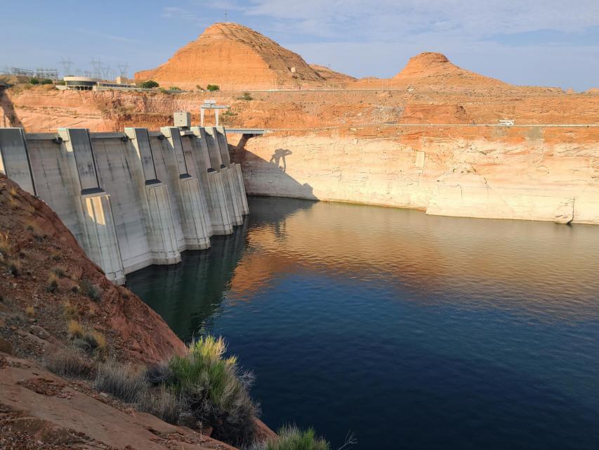
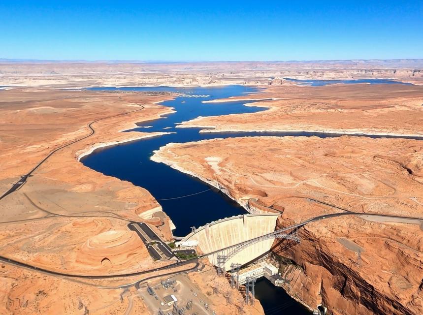
The federal government may reduce releases from Glen Canyon Dam (pictured above) in 2023 by an unprecedented 2-3 million acre-feet, a move that would trigger severe cuts in the Lower Basin. (Source: Bureau of Reclamation)
Sources tell KUNC that delegates from the seven states have met in Colorado in recent days to hash out a deal, but the details of that meeting have been kept behind closed doors, and experts don’t see an obvious outcome. Negotiations are difficult — and have been for decades — because of the river’s diverse user base and complex, multi-layered governance system. While the river supplies major cities such as Denver, Las Vegas, Phoenix and Los Angeles, 80% of its water is used for agriculture. Farmers in southern California have some of the oldest, and most protected water rights in the Colorado River Basin.
“What you’re talking about are people’s livelihoods and farmers’ livelihoods,” said John Berggren, a water policy analyst at the conservation group Western Resource Advocates. “If you’re an irrigator or a rancher or a farmer, your water is your most important asset.”
Click the link to read the article on the InkStain website (John Fleck):
While we eagerly await whatever it is that might happen this week as the Colorado River basin states struggle to come up with a short term plan to use less water…
It’s a crazy time, and I worry about our collective capacity, but the river can’t wait, so buckle up!
A brief refresher is perhaps in order
THE SUPPLEMENTAL EIS
I emerged from the writing cave (new book underway about the Rio Grande, which is a mostly a different river entirely) to share my thoughts about this week’s “deadline” (which as I explained isn’t really a “deadline”) for the seven Colorado River basin states to come up with a plan for managing the river for the next several years. This is a short-term effort, an attempt to limp through the 2025-26 time frame without breaking things. It requires temporary rules to reduce water use as needed in the Lower Basin, maybe some water use reductions in the Upper Basin, and tweaks to the reservoir operations rules to keep from breaking Glen Canyon Dam.
“EIS” here stands for “Environmental Impact Statement”, the process by which Reclamation will analyze our choices before picking one.
The key words here are short term.
THE REAL EIS
Post-2026, we need a much more robust and long-lasting framework for using less water and not breaking the dams and trying to respect tribal sovereignty and our evolving societal values around respect for the environment in the face of climate change stealing a bunch of our water.
In that regard, Reclamation has launched an expansive effort to help us collectively, as a society, think through these options.
A bunch of us wrote them letters last year telling them what we thought they should think about. They’ve summarized them nicely (pdf here). My favorite part is the people from Costa Rica and the UK who weighed in. This is a far-reaching issue.
THE CONNECTION BETWEEN THE SUPPLEMENTAL EIS AND THE REAL EIS
One of the difficulties in sorting out the near-term plans is that everyone’s angling for the high ground in the long-term plans. There’s a fear among water managers that if in the short term they demonstrate that they’re able to get by with less water, they’ll get screwed long term. A lot of what we figure out in the short term will echo into the long term.
HOMER’S ODYSSEY
In season one of the Simpson’s, there’s a great episode called “Homer’s Odyssey” where Homer Simpson gets fired from the nuclear power plant and then becomes a citizen safety advocate who gets speed bumps and stop signs installed in Springfield, and Homer becomes a revered community leader, and Mr. Burns hires him back to become the chief safety officer at the nuclear power plant.
You didn’t think I meant reciting the entire Homeric epic, did you? I fear one episode of the Simpsons is the most we can hope for right now.
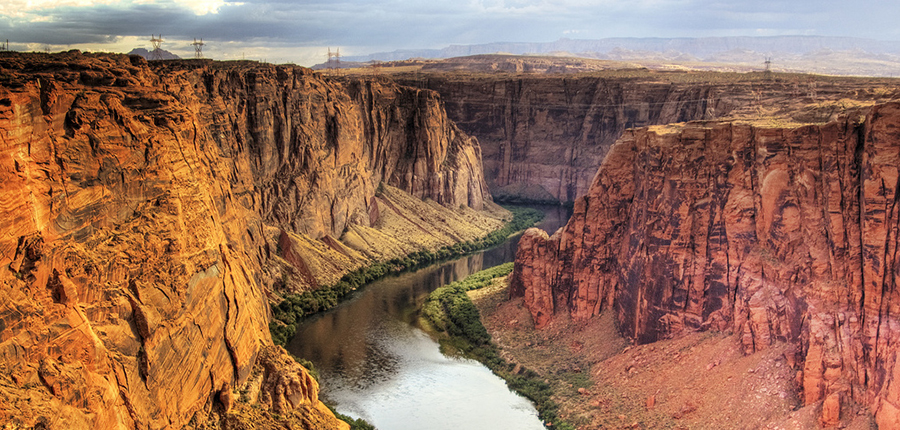
Colorado River. Photo credit: University of Montana
Click the link to read the article on the Associated Press website (Suman Naishadham). Here’s an excerpt:
Exposed to the beating sun and hot dry air, more than 10% of the water carried by the Colorado River evaporates, leaks or spills as the 1,450-mile (2,334-kilometer) powerhouse of the West flows through the region’s dams, reservoirs and open-air canals. For decades, key stewards of the river have ignored the massive water loss, instead allocating Arizona, California, Nevada and Mexico their share of the river without subtracting what’s evaporated. But the 10% can no longer be ignored, hydrologists, state officials and other western water experts say…
The challenge is in finding a method that California also agrees to…
Unlike Arizona, California, Nevada and Mexico, the upriver or Upper Basin states — Colorado, New Mexico, Utah, and Wyoming — already take into account evaporation losses…
One proposal comes from Nevada: States at the end of the river would see their Colorado River portion shrink based on the distance it travels to reach users. The farther south the river travels, the more water is lost as temperatures rise and water is exposed to the elements for longer. The Southern Nevada Water Authority estimates that roughly 1.5 million acre-feet of water are lost to evaporation, transportation and inefficiencies each year in Arizona, Nevada and California. That’s 50% more than Utah uses in a whole year.
Click the link to read the article on the Associated Press website (Kathleen Ronayne and Felicia Fonseca). Here’s an excerpt:
Competing priorities, outsized demands and the federal government’s retreat from a threatened deadline stymied a deal last summer on how to drastically reduce water use from the parched Colorado River, emails obtained by The Associated Press show…
“We are out of time and out of any cushion to allow for a voluntary plan,” Tom Buschatzke, director of the Arizona Department of Water Resources, told a Bureau of Reclamation official in a July 18 email…
As 2023 begins, fresh incentives make the states more likely to give up water. The federal government has put up $4 billion for drought relief, and Colorado River users have submitted proposals to get some of that money through actions like leaving fields unplanted. Some cities are ripping up thirsty decorative grass, and tribes and major water agencieshave left some water in key reservoirs — either voluntarily or by mandate. Reclamation also has agreed to spend $250 million mitigating hazards at a drying California lake bed, a condition of the state’s water users agreeing to cut their use by 400,000 acre feet in a proposal released in October. The Interior Department is still evaluating proposals for a slice of the $4 billion and can’t say how much savings it will generate, Deputy Secretary Tommy Beaudreau said in an interview…
Figuring out who absorbs additional water cuts has been contentious, with allegations of drought profiteering, reneging on commitments, too many negotiators in the room and an unsteady hand from the federal government, the emails and follow-up interviews showed. California says it’s a partner willing to sacrifice, but other states see it as a reluctant participant clinging to a water priority system where it ranks near the top. Arizona and Nevada have long felt they’re unfairly forced to bear the brunt of cuts because of a water rights system developed long ago, a simmering frustration that reared its head during talks…But state officials said when it became clear the federal government wouldn’t act unilaterally, it created a “chilling effect” that removed the urgency from the talks because water users with higher-priority water rights were no longer at risk of harsh cuts, Arizona’s Buschatzke said in an interview…
Reclamation is now focused on weighing the latest round of comments from states on how to save the river. Nevada wants to count water lost to evaporation and transportation in water allocations — a move that could mean the biggest volume of cuts for California — and some Arizona water managers agree, comment letters obtained by the AP show. But disputes remain over how to determine what level of cuts are fair and legal. California’s goal remains protecting its status while other states and tribes want more than old water rights taken into account — such as whether users have access to other water sources, and the effects of cuts on disadvantaged communities and food security. Reclamation’s goal is to get a draft of proposed cuts out by early March, then a final decision before mid-August, when Reclamation regularly announces how much — or how little — river water is available for the next year.
Water users are urgently trying to keep Lake Powell on the Utah-Arizona border from dropping to a point where Glen Canyon Dam can no longer generate electricity. (Source: Bureau of Reclamation)
“Think of the Colorado River Basin as a slow-motion disaster,” said Kevin Moran, who directs state and federal water policy advocacy at the Environmental Defense Fund. “We’re really at a moment of reckoning.”
Negotiators say the odds of a voluntary agreement appear slim. It would be the second time in six months that the Colorado River states, which also include Colorado, New Mexico, Utah and Wyoming, have missed a deadline for consensus on cuts sought by the Biden administration to avoid a catastrophic failure of the river system. Without a deal, the Interior Department, which manages flows on the river, must impose the cuts. That would break from the century-long tradition of states determining how to share the river’s water. And it would all but ensure that the administration’s increasingly urgent efforts to save the Colorado get caught up in lengthy legal challenges. The crisis over the Colorado River is the latest example of how climate change is overwhelming the foundations of American life — not only physical infrastructure, like dams and reservoirs, but also the legal underpinnings that have made those systems work.
A century’s worth of laws, which assign different priorities to Colorado River users based on how long they’ve used the water, is facing off against a competing philosophy that says, as the climate changes, water cuts should be apportioned based on what’s practical. The outcome of that dispute will shape the future of the southwestern United States.
“We’re using more water than nature is going to provide,” said Eric Kuhn, who worked on previous water agreements as general manager for the Colorado River Water Conservation District. “Someone is going to have to cut back very significantly.”
The rules that determine who gets water from the Colorado River, and how much, were always based, to a degree, on magical thinking…But the premise that the river’s flow would average 17.5 million acre-feet each year turned out to be faulty. Over the past century, the river’s actual flow has averaged less than 15 million acre-feet each year. For decades, that gap was obscured by the fact that some of the river’s users, including Arizona and some Native American tribes, lacked the canals and other infrastructure to employ their full allotment. But as that infrastructure increased, so did the demand on the river. Then, the drought hit. From 2000 through 2022, the river’s annual flow averaged just over 12 million acre-feet; in each of the past three years, the total flow was less than 10 million.
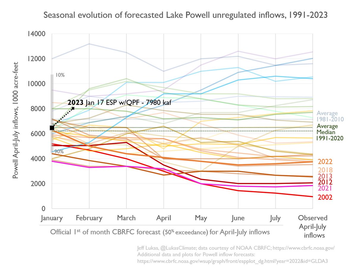
Updated Colorado River 4-Panel plot thru Water Year 2022 showing reservoirs, flows, temperatures and precipitation. All trends are in the wrong direction. Since original 2017 plot, conditions have deteriorated significantly. Brad Udall via Twitter: https://twitter.com/bradudall/status/1593316262041436160
The Bureau of Land Management and a nonprofit entity have teamed up once again on an acquisition by the federal agency of land along the lower Gunnison River, this time involving a 26.32-acre parcel in Mesa County. The BLM’s Grand Junction Field Office partnered with the Western Rivers Conservancy on the acquisition of the Meridian Junction property, on the east side of the river just north of the Mesa/Delta county line. The acquisition furthers partnership efforts to conserve and protect resources for future generations, the agency said in a news release. The land is within the Dominguez-Escalante National Conservation Area, and was bought with money from the federal Land and Water Conservation Fund.
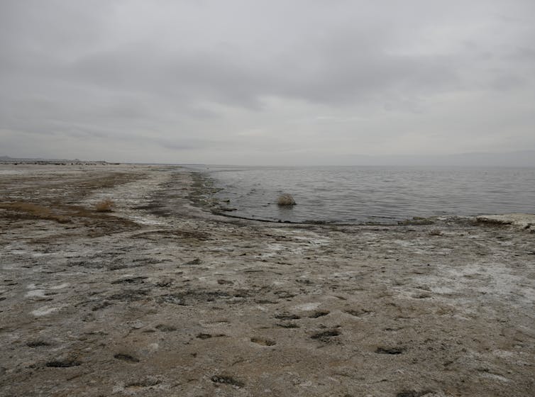
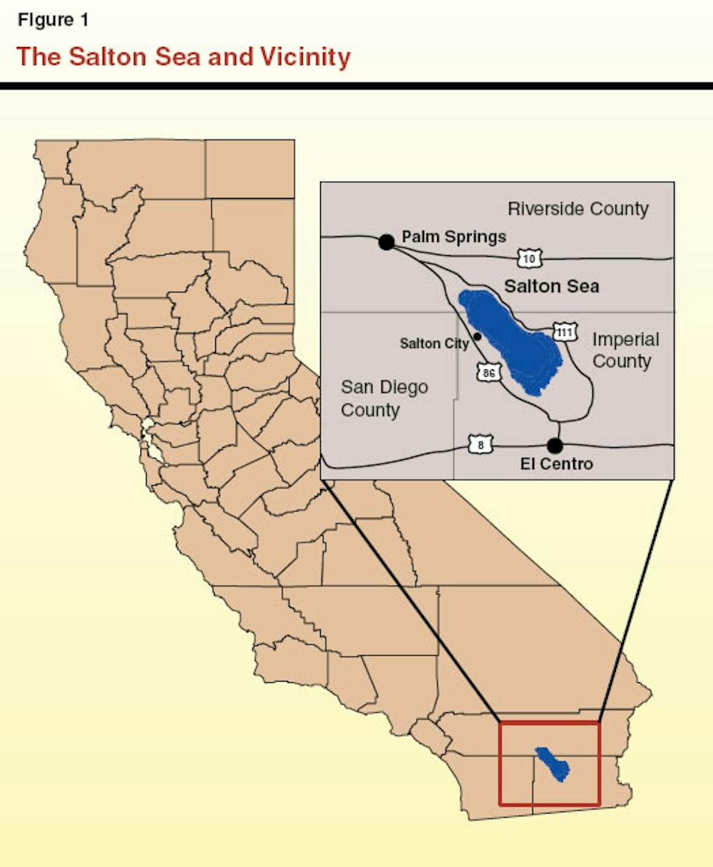
The Salton Sea spreads across a remote valley in California’s lower Colorado Desert, 40 miles (65 kilometers) from the Mexican border. For birds migrating along the Pacific coast, it’s an avian Grand Central Station. In midwinter tens of thousands of snow geese, ducks, pelicans, gulls and other species forage on and around the lake. Hundreds of other species nest there year-round or use it as a rest stop during spring and fall migration.
At the dawn of the 20th century, this massive oasis didn’t even exist. It was created in 1905 when Colorado River floodwaters breached an irrigation canal under construction in Southern California and flowed into a basin that had flooded in the past. In earlier years, the sea covered roughly 40 square miles more than its current size of 343 square miles (890 square kilometers).
Now, however, this resource is in trouble. Wasteful irrigation practices that maintained the sea have been reduced, and excess water is now being transferred to thirsty coastal cities instead. The sea’s volume has declined to roughly 4.6 million acre-feet, losing nearly 3 million acre-feet since the mid-2000s. (An acre-foot is about 326,000 gallons – the amount of water required to cover an acre of land to a depth of one foot).
In November 2022, the federal government pledged US$250 million for environmental restoration and dust suppression at the Salton Sea. It’s a historic contribution, but experts agree that other critical steps are needed.
We just completed more than a year of service to the California Salton Sea Management Program’s Independent Review Panel, which was charged with evaluating proposals to import water to the sea. In our view, the panel’s recommendations represent the best path forward. They also reflect the complexity of managing water in the increasingly dry U.S. Southwest, where other water bodies, such as Utah’s Great Salt Lake, share the same general challenges of net water loss.
An ecosystem on the brink
There’s no question that the Salton Sea desperately needs a fix. Rising salinity threatens worms, crustaceans and other organisms that make up the base of the sea’s food web and has killed off many of its fish species. Without intervention, the sea’s entire ecosystem could collapse.
Without government intervention, the sea would reach a lower equilibrium size by 2045 that matches smaller inflows with evaporation losses. Even greater areas of playa would be exposed, potentially generating even more airborne dust. https://www.youtube.com/embed/KOcB0A3K_bw?wmode=transparent&start=13 Land managers and local residents explain how the Salton Sea’s decline is affecting people and wildlife.
These schemes called for building immense desalination plants along the Sea of Cortez, up to 10 times bigger than California’s Claude “Bud” Lewis plant in Carlsbad – the largest such facility in the United States.
The proposals could not overcome three significant problems. First, they were projected to cost many tens of billions of dollars and take more than 20 years to complete. Second, they threatened to inflict nasty environmental consequences on the Sea of Cortez, dumping huge quantities of brine into sensitive and protected marine ecosystems and turning pristine beaches into industrial zones. Third, Mexico would derive little benefit from building a huge desalination plant in a remote area, other than some jobs from building and running the plant. https://cdn.knightlab.com/libs/juxtapose/latest/embed/index.html?uid=1c70a2bc-9035-11ed-b5bd-6595d9b17862 These satellite photos show how the Salton Sea shrank between 1984 and 2015, exposing dry playa around its edges (move slider to compare years).
Focus on salinity, not size
Ultimately, the panel concluded that expanding the Salton Sea to its former size was less important than controlling its salinity. The panel made four recommendations that center on building a desalination plant at the Salton Sea to the treat water that’s already there.
This plant would remove 200 million gallons of high-salinity water daily from the Salton Sea and produce 100 million gallons per day of desalinated water, which would be returned to the Salton Sea. In short order, this exchange would begin to significantly lower its overall salinity.
A desalination plant using reverse osmosis generates a brine stream equal to approximately half the volume of the treated seawater. Accordingly, the panel called for California to negotiate a voluntary paid transfer program in which the state would pay farmers to transfer enough water to the Salton Sea to replace the volume of brine removed at the desalination plant. The net effect would keep the sea from becoming even smaller and hasten the process of lowering salinity.
The desalination plant would generate an immense quantity of salt, which would require careful disposal. The panel recommended drying out the brine in evaporation ponds and transferring dried salts from the ponds to landfills or industrial uses.
Finally, the panel called for California to step up support for an aggressive program to stabilize the exposed playa. Techniques could include planting vegetation on the playa and plowing long rows of furrows to reduce dust mobilization during wind storms. The estimated total cost for this plan is $63 billion, compared with $95 billion-$148 billion for various proposals to desalinate and import water from the Sea of Cortez.
Since 2020, the state has conducted pilot projects to reduce dust blowing off the playa, with promising early results. The federal government’s $250 million pledge will enable this work to move more quickly.
Stabilizing the playa is essential to address significant public health concerns associated with windborne dust, although more must be done regionally to fully address air quality problems.
Looking forward, not backward
This approach will not satisfy critics who want to restore the Salton Sea to its maximum volume. These advocates recall the mid-20th century when the sea was a tourism draw and would like to reconnect the few small towns that once bordered the sea, which are now separated by extensive playa. Expanding the sea to its original size also would address concerns about playa-sourced air pollution.
In our view, however, the panel’s recommendations offer a genuine opportunity to solve the main problems: blowing dust and increasing salinity. This solution is more likely to actually be implemented than an enormous binational desalination project. It would happen more quickly, at about half the cost of the binational importation options.
We believe that the sooner California officials accept the reality of a smaller Salton Sea, the sooner the state can move ahead, focusing on air quality improvement and ecological restoration.
The reservoir would be a joint project between SJWCD and the PAWSD called the San Juan River Headwaters Project. In 2008, SJWCD and PAWSD collaborated on the purchase of the property, also known as Running Iron Ranch, with the goal to even- tually build a water storage facility on the parcel of land, which is more than 600 acres. The proposed reservoir would be an “off-channel” water storage facility being fed by a pre-existing agricultural ditch, Park Ditch…
According to the district’s strategic plan, “In 2004, the District and PAWSD applied for a junior water right for a larger reservoir in Dry Gulch, a refill right, and specific filling sources and rates for it. Trout Unlimited opposed those claims, leading to protracted litigation and new standards from the Colorado Supreme Court for evaluating conditional water rights owned by municipal providers. The District, PAWSD, and Trout Unlimited eventually stipulated to a decree providing for a maximum storage capacity of 11,000 acre-feet for Dry Gulch Reservoir and other limitations on its use.”
More recently, SJWCD sought more accurate information on projections for future water needs, hiring the Lakewood-based water consultant company Wilson Water Group to conduct the analysis. The resulting study was a 24- page “analysis of current and future water supply and demand through 2050 in the Upper San Juan River basin.”
The first novel item on the [Carbondale Board of Trustees] agenda was a proposal from the Ruedi Water and Power Authority (RWAPA) for regional baseline watering standards. The proposition was developed through a grant from the WaterNow Alliance and stakeholder meetings with water suppliers in the Valley. RWAPA Executive Director April Long joined via Zoom to explain that the desire for comprehensive and regional education is complicated by disparate restrictions between jurisdictions in the watershed. “The entire point of baseline watering standards is just to give us initial footing … for an education and outreach campaign,” she stated.
An extensive memo provided by Public Works Director Kevin Schorzman explained that the town code currently recognizes few scenarios for restrictions: a water shortage or a water crisis. Conservation restrictions may be enacted during periods of peak demand, from May 15 to Oct. 15.
The proposed Valley-wide standards would make permanent no watering between 9 a.m. and 6 p.m. year-round, with odd addresses and even addresses alternating days and no watering on Mondays — with some exceptions.
Crystal River rancher Bill Fales stands at the headgate for the Helms Ditch, with Mount Sopris in the background. As part of an agreement with the Colorado Water Trust, Fales could be paid to reduce his diversions from the ditch when the river is low. CREDIT: HEATHER SACKETT/ASPEN JOURNALISM
Schorzman’s memo also explained that Carbondale’s system is unique, with treated water as well as an extensive ditch system supplying raw water for irrigation. The memo noted that Carbondale’s indoor water use per capita has trended downward in recent years and approximately 58% of “consumed” domestic water returns to the river as wastewater return flows. Long stated that ditch water should follow the same standards as treated water.
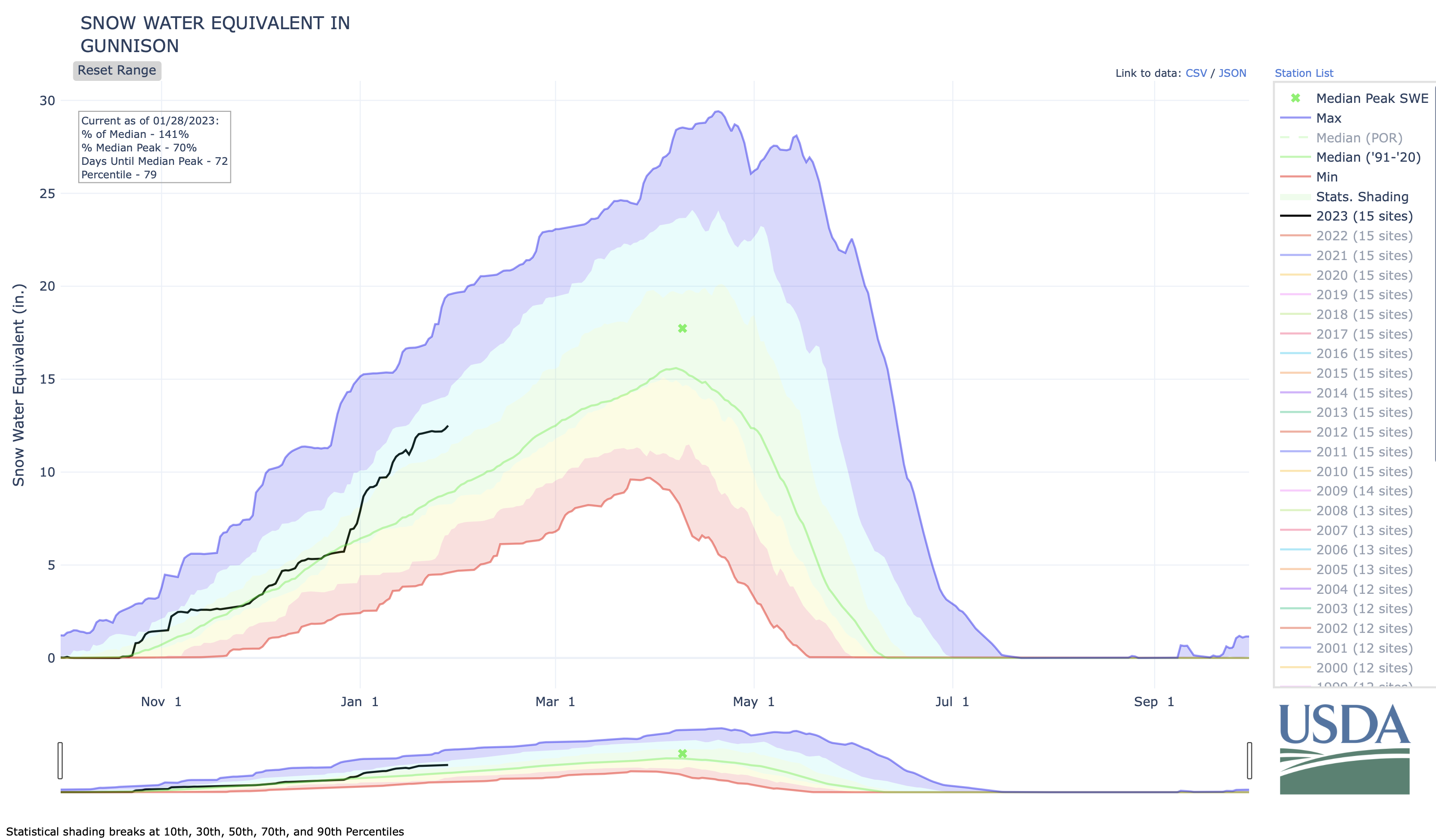
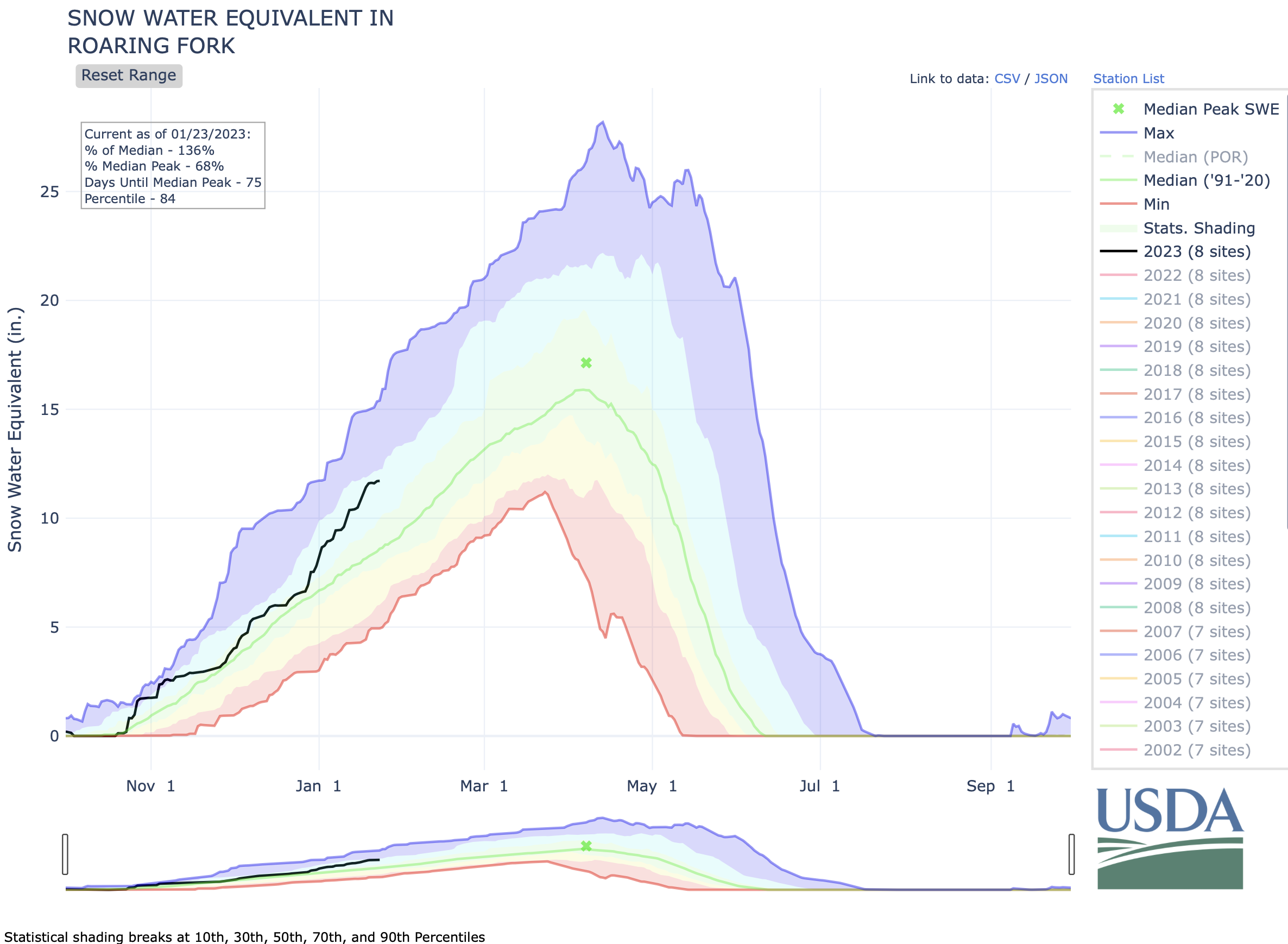
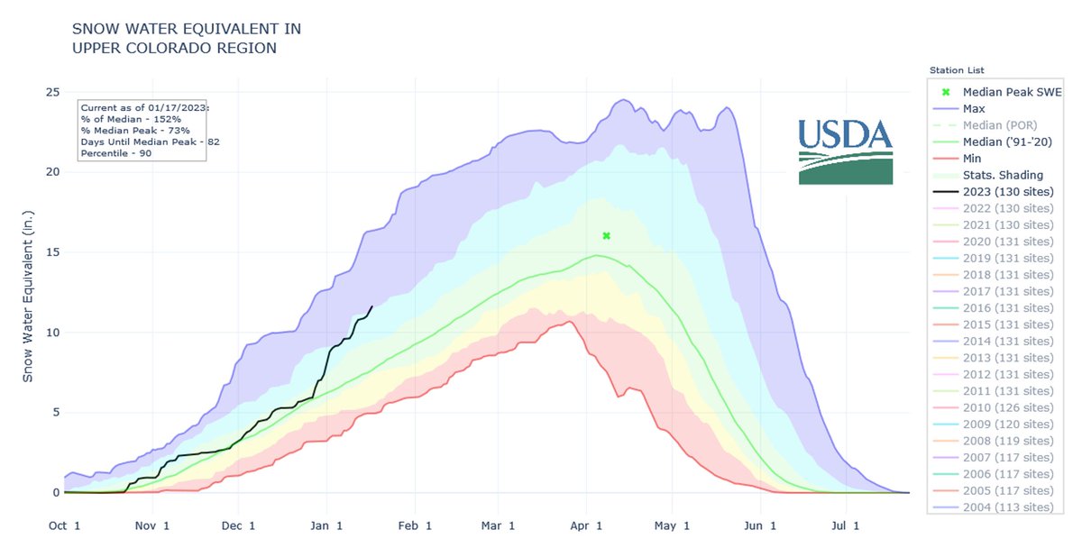
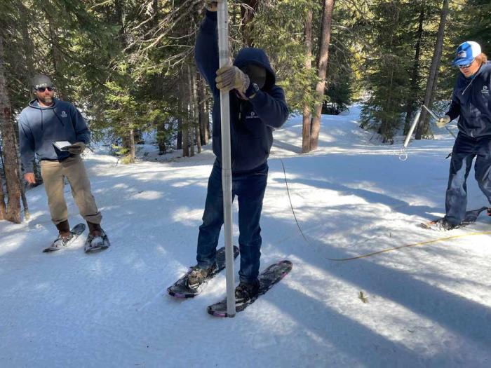
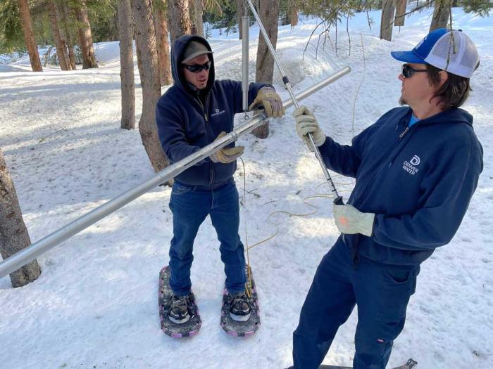
It is too early to draw definitive conclusions in terms of the Gunnison Basin’s water situation even given the consistent snowstorms we have experienced recently. But it is currently in a good spot. While the Gunnison Basin is recording snowpack that is significantly above average and is about even with where were last year at this time even after a 99-inch snowstorm barreled through the area in late 2021 and early 2022, it takes more than good December and January snow to ultimately fill the reservoirs.
“It’s too soon to say what our water year might look like,” cautioned Upper Gunnison River Water Conservation District (UGRWCD) general manager Sonja Chavez. “As we saw last year, we had a great snowpack through January and then it stopped snowing. We didn’t see any significant storm events the rest of the winter season. Then, wind and dust on the snowpack was a problem, and our snowpack disappeared before our eyes.”
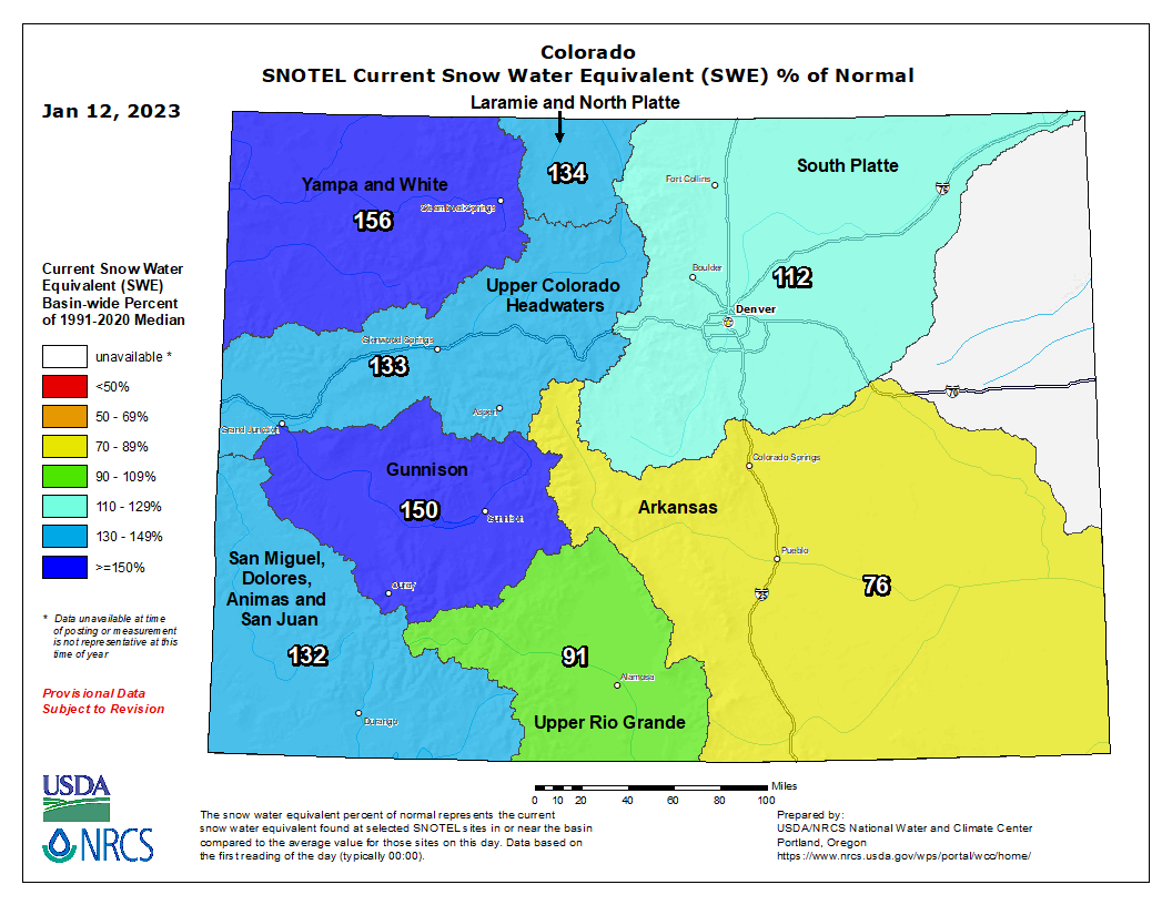
According to UGRWCD water resource specialist Beverly Richards, last week the area in general was recording 140% above average snowpack and that has dropped a bit this week to 133%. The water content is at 129% of average, which is a good sign…
Billy Barr photo via Sotheby’s
“This winter is doing quite well especially after a very weak start,” he reported. “The snowpack is well above average, though the past week’s snow was much lighter in water than everything earlier. That means it is still settling and catching down to the average. But this is a good winter, if not anything overly special. Last year’s end of December storm was big, but that was pretty much the winter while this year has been steady, which is more like it tended to be in the past.”
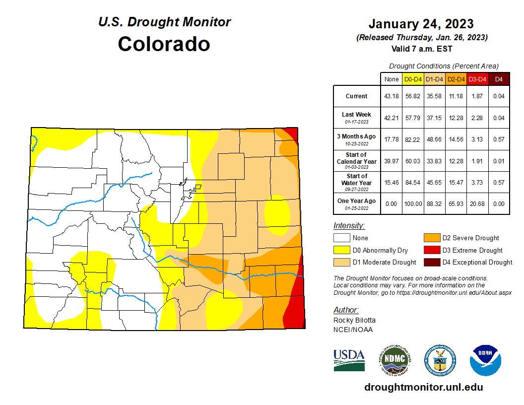
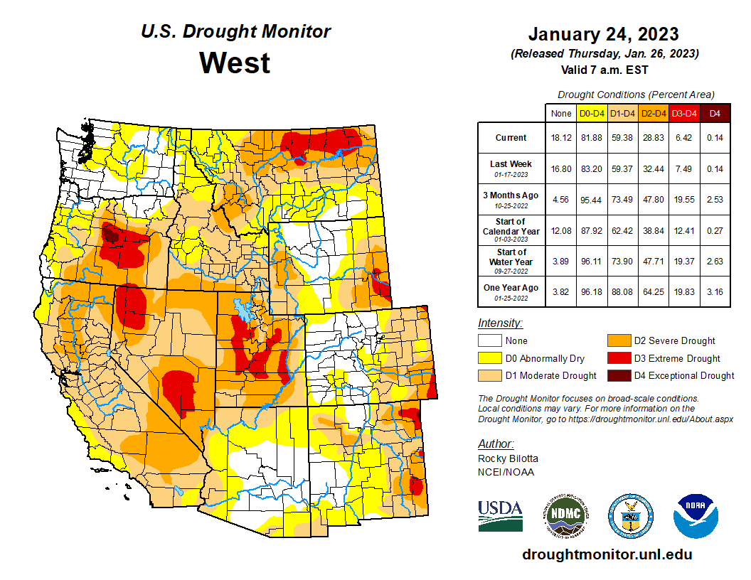
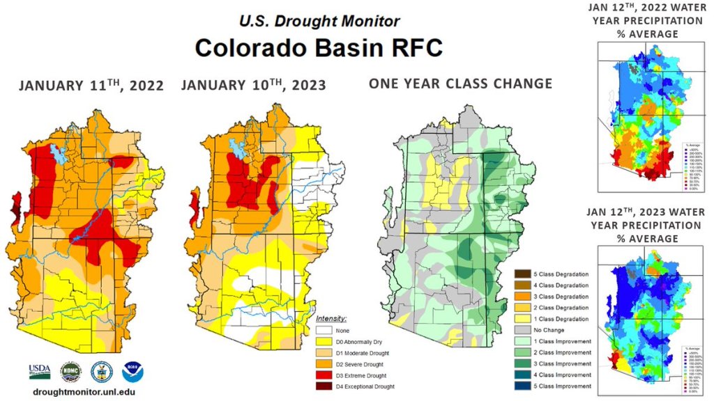
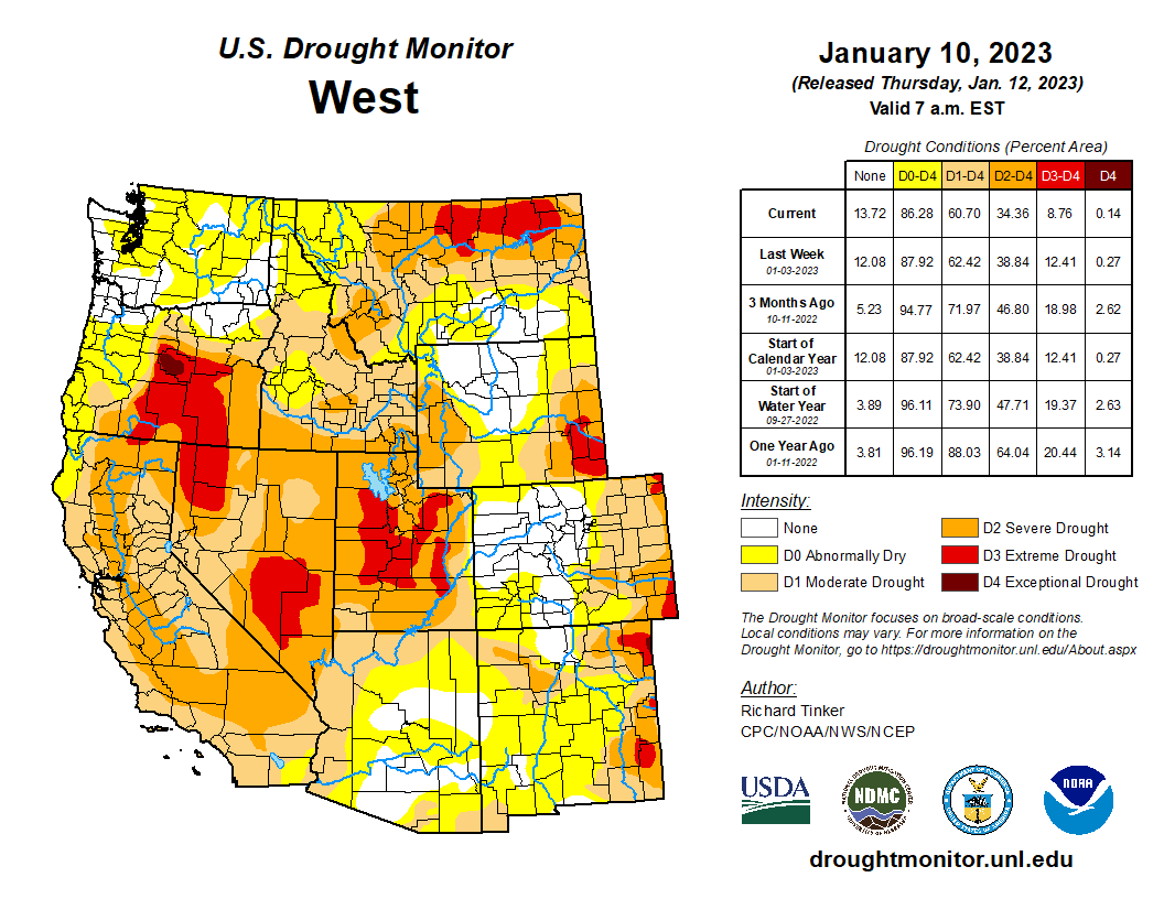
Weeks of back-to-back storms in Southwestern Colorado have not lifted the area out of drought.
There’s still bright news, though: Those storms have beefed up the snow-water equivalent in the Gunnison River Basin to 142% of average for this time of year, as of Jan. 25. According to U.S. Bureau of Reclamation data, actual snow accumulation was only 67% of average in November of last year, but was 115% of average come December. Hydrologists didn’t celebrate — the previous December had been comparable, but January 2022 dried out considerably. This January, things are different.
“We are doing pretty well for snow so far,” said Bureau of Reclamation hydrologist Erik Knight. “That’s a good situation. … We were about 200% of average for the first two weeks.”
The first weeks’ snowfall this year is above what has been recorded for the entire month of January most years, he said…That was especially true at Snotel measurement sites near Butte and Schofield, where the snow-water equivalent came in at 4.9 inches and 9.7 inches, respectively, for January. The average, to-date SWE at those sites is 1.8 inches and 3.8 inches, while the average January total is 2.9 inches and 6.7 inches…
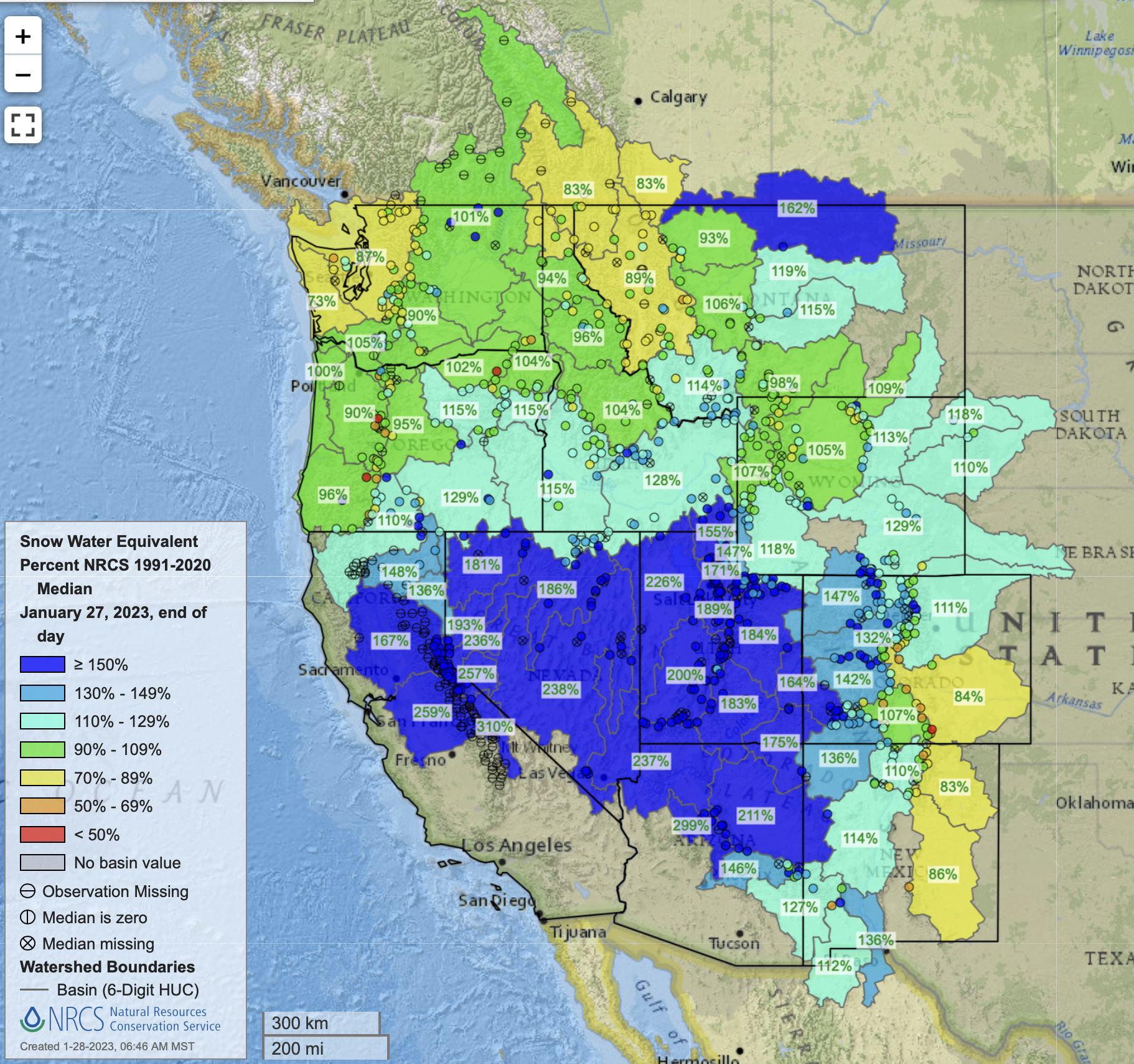
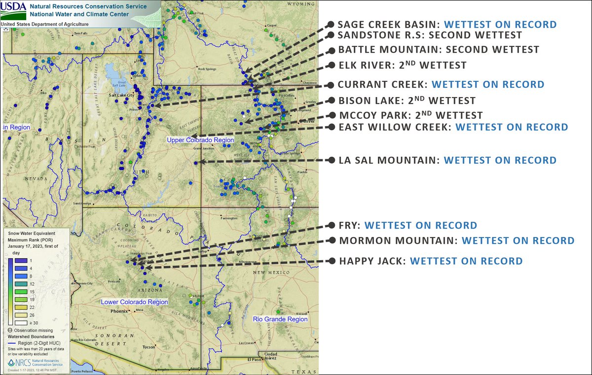
West snowpack basin-filled map January 27, 2023 via the NRCS.
Snow-water equivalent is above average in basins across the West, according to Saffell’s data. “We’re happy to see that. We’re hopeful it maintains. Do understand that this can change,” she said. Soil moisture percentages are a “good sign” that conditions will allow for efficient runoff as peak runoff time nears. Colorado’s peak melting time is usually in April – May. “We’re happy to see these kinds of things, allowing us to hold onto that water,” Saffell said.
Water users are urgently trying to keep Lake Powell on the Utah-Arizona border from dropping to a point where Glen Canyon Dam can no longer generate electricity. (Source: Bureau of Reclamation)
Another deadline to establish new cutbacks in water use in the seven-state Colorado River Basin is quickly approaching on January 31, 2023, as states continue their talks, as ordered by the U.S. Bureau of Reclamation.
In addition to the cutbacks, several other key decisions also lie ahead in the coming weeks, including how a $125 million, broad-based water conservation pilot program would operate, whether a permanent water conservation program known as demand management could work among the Upper Basin states, and how the third-year of an emergency drought plan, known as the Drought Response Operations Agreement, will function this spring and summer.
All are tied to reducing short-term and long-term demands on the drought-strapped river as part of a five-point plan put forward by the Upper Basin states last summer. In releasing that plan, the Upper Basin recognized its effectiveness would hinge on additional actions to reduce use in the Lower Basin.
The U.S. Bureau of Reclamation late last year had given the seven basin states until Jan. 31 to come up with a new agreement on water reductions, after an August deadline had passed.
Becky Mitchell, director of the Colorado Water Conservation Board who also represents Colorado on the Upper Colorado River Commission, said talks were continuing but that more work and specific plans from California, Arizona and Nevada would be necessary to reach an agreement and take action.
“The basin states, the federal government, and the tribes have been working collaboratively and tirelessly to find potential points of consensus on short-term actions to protect lakes Powell and Mead,” Mitchell said Monday at a meeting of the Colorado Water Conservation Board in Aurora.
“I continue to believe strongly that the Lower Basin states must take action to reduce their demands out of Lake Mead.
“We are moving forward on our commitments, but it is important to recognize that those commitments and that work alone mean nothing if the Lower Basin use continues as it has been,” she said. She also stressed the importance of considering what must occur in the Lower Basin before Colorado moves forward with widespread participation in the System Conservation Pilot Program.
Map credit: AGU
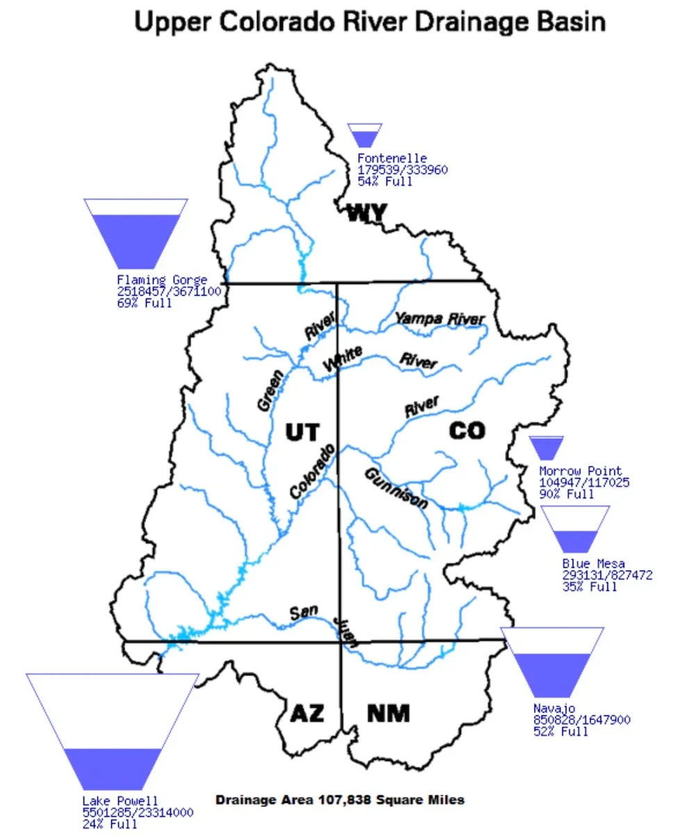
The basin is divided into two regions. The Upper Basin includes Colorado, New Mexico, Utah and Wyoming, while the Lower Basin covers Arizona, California and Nevada.
Last summer U.S. Bureau of Reclamation Commissioner Camille Touton ordered the states to figure out how to reduce water use by 2 million to 4 million acre-feet by August, but no agreements have been reached. Now the states, along with tribal leaders and the feds are aiming to agree to cuts by Jan. 31. If no consensus is reached next week, it leaves the possibility that the federal government will decide how to make the cuts in the coming weeks.
As lakes Powell and Mead have dwindled, all seven states have had to get by with less water and federal forecasts indicate that is likely to be the case for several more years.
West snowpack basin-filled map January 27, 2023 via the NRCS.
Since December, the water forecast has improved slightly thanks to heavy mountain snows in Utah and Colorado, according to Michelle Garrison, a water resources specialist at the Colorado Water Conservation Board.
“Snowpack and runoff in all of western Colorado and Utah is quite a bit above average … but from here on, it could get really dry just like it did last year. So folks need to be prepared to plan for a continued wet or a sudden drop to really dry or anything in between as they’re looking forward,” Garrison told the board.
Now 23 years into a megadrought widely believed to be the worst in 1,800 years, the highly developed river system is on the brink of collapse, with lakes Powell and Mead falling dangerously close to dead pool, a water level so low that, if it is reached, Powell won’t be able to produce hydropower and Mead won’t be able to serve the millions of people in the Lower Basin who rely on the river.
Colorado River headwaters tributary in Rocky Mountain National Park photo via Greg Hobbs.
The river begins in Colorado’s Never Summer Mountains, high in Rocky Mountain National Park. It gathers water from major tributaries in Colorado, such as the Yampa and Gunnison rivers, and throughout the Upper Basin, accumulating some 90% of the streamflow that it will provide throughout the seven-state river system thanks to the runoff from the Upper Basin’s deep mountain snows.
But since 2002, those mountain snowpacks have been shrinking, crushed by warming temperatures and fewer snow days.
Beginning in July of 2021, the U.S. Department of the Interior ordered, for the first time, emergency releases from Utah’s Flaming Gorge, Colorado’s Blue Mesa and New Mexico’s Navajo reservoirs. But that has done little to restore levels, although the releases are credited with providing some protection to the power supply.
While Lower Basin states have been forced to begin cutting back water use under a special set of operating guidelines and drought plans approved respectively in 2007 and 2019, negotiations in recent months have failed to achieve the federally ordered cutbacks. Upper Basin states are considering new programs and actions to further cut Upper Basin water use, but are hoping for additional Lower Basin commitments before taking additional water use reductions of their own.
West Drought Monitor map January 24, 2023.
At the same time, the drought has continued, and this winter could be dry once again, particularly in the Lower Basin. In response, last week, the federal government announced it would expedite negotiations on a new set of operating guidelines designed to protect lakes Powell and Mead to help restore the river.
Under the terms of the Colorado River Compact of 1922, the river’s supplies are divided equally between the Upper and Lower basins. But because the Upper Basin states have smaller and fewer reservoirs than the Lower Basin, users here have had to cut back their water use as the drought has continued. At the same time, Lower Basin users have been able to rely on stored supplies in Powell and Mead, at least until now.
Looking ahead, Jessica Brody, who represents the Metro Basin on the CWCB Board of Directors, said she would like to see more time taken before critical Upper Basin decisions are made, including participation in the $125 million System Conservation Pilot Program, which is accepting applications through Feb. 1.
“I’m a little bit concerned about the Feb. 1 deadline when we don’t yet know whether the Lower Basin will be able to come to the table in terms of reducing the demands in the Lower Basin,” Brody said.
Jerd Smith is editor of Fresh Water News. She can be reached at 720-398-6474, via email at jerd@wateredco.org or @jerd_smith.
An image of the Crystal River Valley from an EcoFlight mission in August 2022. The view is downvalley, toward Mount Sopris. A group is exploring a federal designation of wild and scenic for the Crystal River in Gunnison and Pitkin counties.
Courtesy of Ecoflight
The effort to explore getting a federal designation of wild and scenic for the Crystal River is about to get turned up a notch. The Wild and Scenic Feasibility Collaborative announced Monday it has selected Wellstone Collaborative Strategies and P2 Solutions to facilitate and lead a community engagement and stakeholder process. American Whitewater, a national nonprofit that advocates for the preservation and protection of whitewater rivers, will support Wellstone in the administration of its outreach efforts…
Denver-based Wellstone Collaborative Strategies and Loveland-based P2 Solutions were selected for their experience and competence in facilitation and community engagement. Both Jacob Bornstein, founder and principal of Wellstone Collaborative Strategies, and Wendy Lowe, owner of P2 Solutions, have demonstrated exceptional facilitation skills and experience shepherding broad community conversations to successful outcomes, according to a statement from the selection committee, according to an announcement. The principals in the businesses have strong backgrounds in natural resource issues and direct knowledge of the Crystal River…
With a goal of identifying long-lasting river protection, the collaborative envisions the creation of a stakeholder group that would engage in fact finding, identification of overlapping interests and concerns, and a robust discussion of shared goals and strategies. The initial phase of the stakeholder process will bring together a representative cross section of interested individuals to provide informed input; examine, explore and investigate river protection; access and rely on experts in river and riparian health; engage experts to provide factual information relevant to protective designations; agree upon rules of engagement; be a process grounded in the highest integrity and inclusiveness; and result in identification of shared principles for protection of the Crystal River.
Map of the Roaring Fork River drainage basin in western Colorado, USA. Made using USGS data. By Shannon1 – Own work, CC BY-SA 4.0, https://commons.wikimedia.org/w/index.php?curid=69290878The Crystal River just below Avalanche Creek on June 3. Streamflows near this location peaked on May 19 at 1,840 cfs according to data from the Colorado Basin River Forecast Center. CREDIT: HEATHER SACKETT/ASPEN JOURNALISMProtecting continued public access to these waterfalls along Yule Creek, just over the property line from a parcel set to be donated to a land conservation agency, is an ongoing priority for the CVEPA.
CREDIT: COURTESY PHOTO BY JOHN ARMSTRONGThe view looking upstream on the Crystal River below Avalanche Creek. A Pitkin County group wants to designate this section of the Crystal as Wild & Scenic.
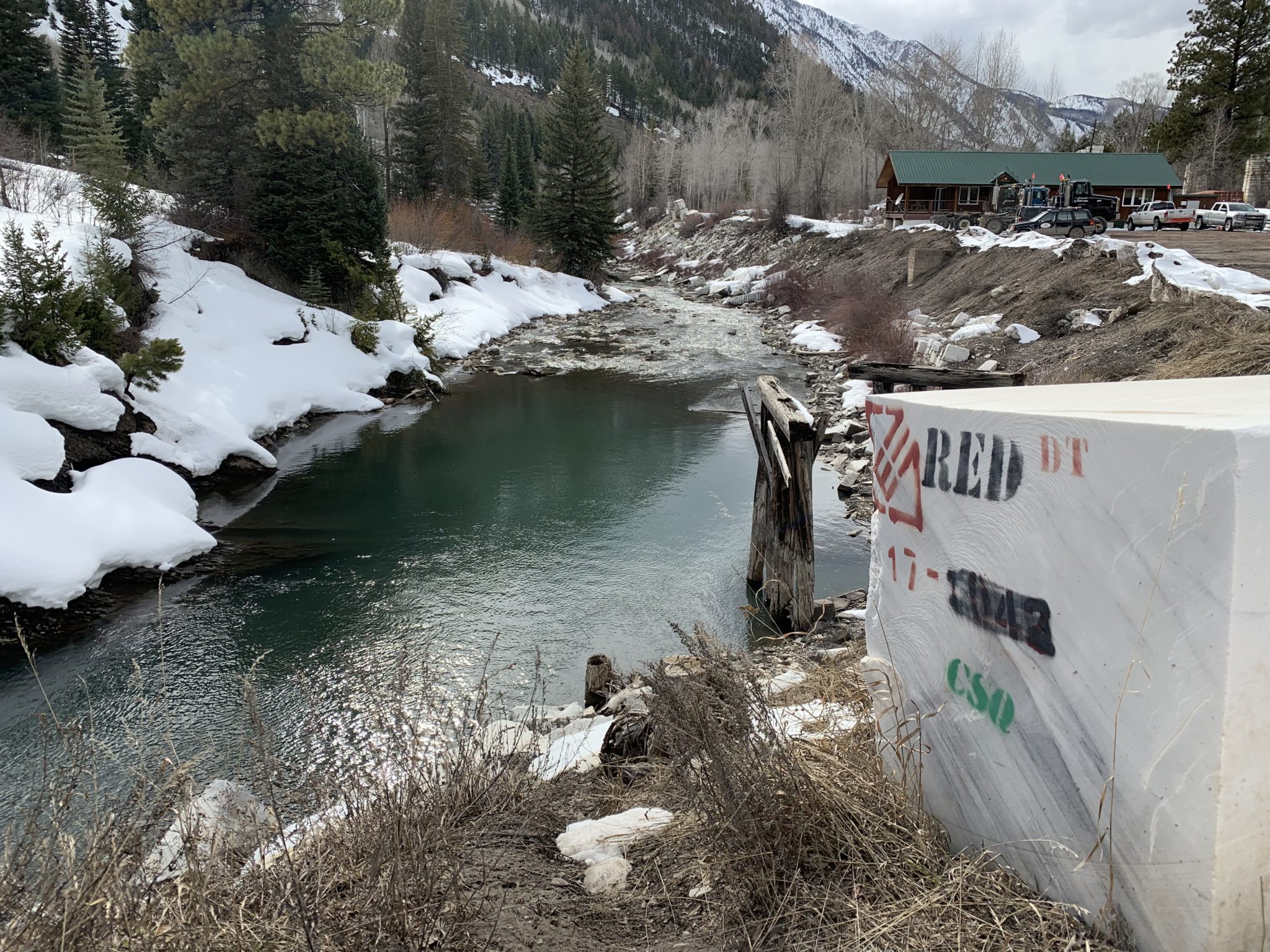
CREDIT: CURTIS WACKERLE/ASPEN JOURNALISMThe Crystal River flows through the town of Marble just after its confluence with Yule Creek. Gunnison County, Pitkin County and local environmental groups want to see a marble mining company mitigate its illegal relocation of a creek by improving downstream riparian habitat. Photo credit: Heather Sackett/Aspen Journalism These marble blocks stamped with quarry owner’s name, Red Graniti, and operator’s initials, CSQ, line the banks of the Crystal River near the company’s load-out area in the town of Marble. The U.S. Army Corps of Engineers is considering whether to issue the operator a retroactive permit to allow it to move a stream. Photo credit: Heather Sackett/Aspen JournalismThe narrows on the Crystal River just below Placita where a dam big enough to store 62,009 acre-feet of water was once planned by the Colorado River District and the West Divide Water Conservancy District. The Pitkin County BOCC passed a resolution opposing the River District’s proposed tax increase. Photo credit: Brent Gardner-Smith/Aspen JournalismLooking upstream toward the confluence of the Roaring Fork River, left, and the Crystal River, right, just below Carbondale. More information about these and other rivers will be made available to the public with the help of a recent $37,000 state grant to the Roaring Fork Conservancy. Photo credit: Brent Gardner-SmithCrystal River near Redstone via Wikipedia CommonsCrystal River via Aspen JournalismCrystal River
Click the link to read the article on The Deseret News website (Kyle Dumphey). Here’s an excerpt:
Utah’s Washington County is one of the fastest growing areas in the country, according to the U.S. Census Bureau, made possible by the Virgin River which supplies the region and its multiplying suburbs with water. But drought and population growth have long plagued the river, and the mayor of Ivins, a small, bedroom community of nearby St. George, did not mince words when addressing constituents this month.
“There’s good cause to be concerned about water,” said Mayor Chris Hart during an annual neighborhood meeting in January. “We are running out.”
Hart said the city has run out of water previously, dating back to the 1960s — “but there was always a solution, because we hadn’t fully developed the sources of water. That’s coming to an end.”
“We’ve just about used up all of the Virgin River drainage and our only hope is that we can convince enough of us to conserve better,” he continued…
Lake Powell Pipeline map via the Washington County Water Conservancy District, October 25, 2020.
Hart, who served on the Washington County Water Conservancy Board, said much of the region’s growth is predicated on construction of the Lake Powell Pipeline, a $3 billion project that would funnel 80,000 acre-feet of Utah’s Colorado River allotment from the Glen Canyon Dam to the St. George area.
Click the link to read the article on the Aspen Daily News website (Austin Corona). Here’s an excerpt:
An ongoing water case in Colorado’s Division Five water court in Glenwood Springs could impact a vital source of water for users across the Western Slope. The case developed from a dispute between the Snake River Water District in Summit County and the state’s Division 5 Engineers regarding administration of Green Mountain Reservoir’s Historic User Pool. The case could affect thousands of water users in Colorado’s portion of the Colorado River Basin, including many in the Roaring Fork Valley, who rely on releases from Green Mountain Reservoir. Snake River and the Division 5 Engineers of the Colorado Division of Water Resources disagree on whether Snake River can benefit from water in Green Mountain’s Historic User Pool. Snake River relies on water from the HUP to replace the water it removes from the Snake River system with several wells…
The HUP was created to compensate Western Slope users for water transferred out of the Colorado River Basin to the Front Range. While the HUP itself was only created in 1983, Western Slope water users have been relying on water from Green Mountain since the 1950s. The HUP, along with other allotments of water in the reservoir, were legally designated in order to ensure that Green Mountain would continue as a critical resource for the Western Slope. Snake River is one of thousands of Western Slope water users who rely on the HUP to replace water diverted from the Colorado River and its tributaries.
The Division 5 Engineers challenge Snake River’s ability to benefit from the HUP because Snake River also receives replacement water through an augmentation plan. Augmentation plans are court-approved plans that also replace water diverted by users, but they are not necessarily linked to Green Mountain, and using them is not free. Because Snake River can already replace its diversions during a call with augmentation water, the engineers say it cannot benefit from HUP coverage…Snake River sued the engineers in Colorado’s Division 5 water court in hopes of retaining its HUP benefits. If it loses its HUP coverage, Snake River claims it could cost $800,000 to rely exclusively on its augmentation plan. Snake River argues that coverage from an augmentation plan does not legally disqualify a water user from also being covered by the HUP.
Lake Powell, a key reservoir on the Colorado River, has seen water levels drop precipitously as a result of two decades of drought. (Source: The Water Desk and Lighthawk Conservation Flying)
Click the link to read the article on the Audubon website (Jennifer Pitt):
The massive dams on the Colorado River were supposed to protect us.
President Franklin Roosevelt at dedication of Boulder (now Hoover) Dam, September 30, 1935
Today, the water stored behind them is so diminished that the federal government has warned of “system collapse.” The two reservoirs are dangerously close to dead pool, the point at which the water level sinks below the dams’ intakes. At risk are the 40 million people who rely on the Colorado River water supply and a substantial share of the U.S. agricultural economy, not to mention the hundreds of bird species and every other living thing that depends on the basin’s rivers as habitat.
How did this happen? The river is legally overallocated, the basin is experiencing extended drought conditions, and climate warming is exacerbating the drought. Perhaps most significantly, consumptive water uses in the past 20 years have exceeded supply. Rather than reducing water uses a little bit year over year, those who control the river (water users, state and federal agencies) largely sustained consumptive uses by draining those reservoirs. Now that they are nearly emptied, that strategy won’t work anymore, and the region is in for a rough transition.
The federal Bureau of Reclamation has initiated a process to substantially reduce water releases from Hoover and Glen Canyon Dams as soon as next year (see “Notice of Intent to Prepare a Supplemental Environmental Impact Statement for the December 2007 Record of Decision Entitled Colorado River Interim Guidelines for Lower Basin Shortages and Coordinated Operations For Lake Powell and Lake Mead” as published in Federal Register Notice – 87 FR 69042 on November 17, 2022). This will allow Reclamation to change Colorado River operations in the near-term without having to enact “emergency measures” (read: not subject to environmental review) as they did in 2022. This is taking place at the same time that Reclamation is working with stakeholders on a longer-term process to revise Colorado River operating rules post-2026.
Sandhill Cranes and Snow Geese. Photo: Marti Phillips/Audubon Photography Awards
In response to Reclamation’s most recent request for public comment regarding near-term changes to Colorado River operations, Audubon submitted a letter asking for considerations for birds and other living things that depend on the river. We expect to comment again once Reclamation issues a draft plan, likely in March.
Updated Colorado River 4-Panel plot thru Water Year 2022 showing reservoirs, flows, temperatures and precipitation. All trends are in the wrong direction. Since original 2017 plot, conditions have deteriorated significantly. Brad Udall via Twitter: https://twitter.com/bradudall/status/1593316262041436160
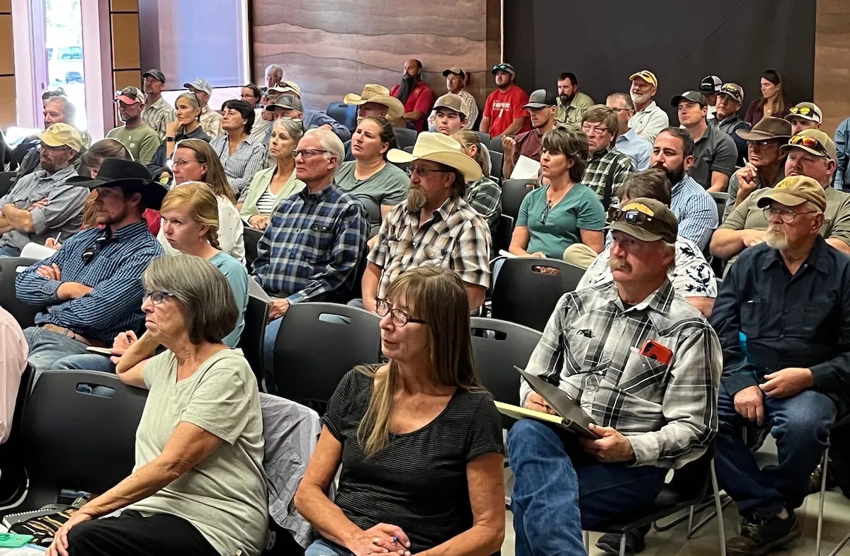
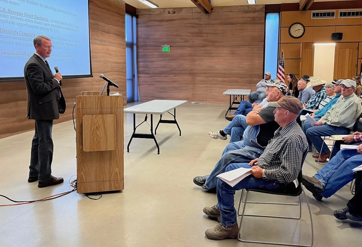
A member of the public poses a question during a public meeting in Saratoga Jan. 12, 2023 regarding the proposed West Fork Dam and reservoir. (Dustin Bleizeffer/WyoFile)
The U.S. Natural Resource Conservation Service will likely request some $20 million for the West Fork Dam on the Colorado border, a potential new funding source for the contested project
The federal Natural Resources Conservation Service will likely request funding “in the over-$20-million range” to help finance a controversial dam proposed for the Little Snake River drainage, a federal official said last week.
The revelation emerged from a long-awaited series of public meetings in Craig, Colorado, Baggs and Saratoga during which project critics and proponents interrogated state and federal agency representatives and argued the merits of the West Fork Dam initiative.
Estimated in 2017 to cost $80 million, the 260-foot-high concrete structure and accompanying 130-acre reservoir in Carbon County near the confluence of Battle and Haggarty Creeks has become the latest skirmish line in the West’s interminable water wars.
Water developers and many in the local agricultural community hail the public work as a critical tool for mitigating the effects of deepening drought and a boon for wildlife, recreation and the local economy. Opponents describe it as an expensive boondoggle poised to benefit a small number of irrigators — many of whom aren’t even in Wyoming — while shifting negative environmental impacts downstream.
Following years of quiet agency maneuvering, legislative negotiating and campaigning from both sides, a framework for the potential deal has taken shape. It involves a state-federal land swap, complex “public benefit” calculations, a streamlined environmental review, majority funding from the state of Wyoming, minority contributions from water-users and now, apparently, a potentially skid-greasing influx of federal dollars.
The NRCS’s funding interest was “some new info,” according to a participant at one of last week’s public meetings.
The Natural Resources Conservation Service will request funding if it and other agencies approve construction, said Shawn Follum, state conservation engineer with the NRCS in Casper.
Funds aren’t guaranteed, he said; “We can’t commit Congress’ dollars in the future.” But the money could qualify as the required contribution from the Pothook Water Conservancy District of about two dozen irrigators in Colorado, according to discussions at the public meetings.
Wyoming may still face challenges funding the dam if federal officials approve it. In an unprecedented move in 2018, state legislators cut some $35 million from a water-construction bill and required lawmaker approval for any new funds for the West Fork Dam.
In an era of infrastructure and stimulus funding, however, more federal money might be available. “The reality is there are a variety of places where to find this … funding,” rancher Pat O’Toole, a project proponent and former state lawmaker, said.
Funding, however, is only one of many variables that need to be solved for if the complex public works proposal is to come to fruition. The terms of a land swap and parallel environmental review are also top of mind for stakeholders, as is an evaluation of who actually stands to benefit from the undertaking.
‘Somewhat befuddled’
Held over three evenings, the meetings drew about 150 people to hear how the NRCS and Medicine Bow National Forest might authorize the proposed dam on the West Fork of Battle Creek.
In what’s being called a “parallel process” The Medicine-Bow will decide whether to exchange land to enable the 130-acre reservoir that would hold 10,000 acre-feet, mostly for late-season irrigation. About 44 irrigators have expressed interest in buying the water, according to discussion at the meetings.
Pat O’Toole, who ranches in the Baggs area, was among participants at the Saratoga public meeting on the West Fork Dam on Jan. 12, 2023. Approximately 150 persons attended three sessions — also held in Baggs and Craig, Colorado — explaining how the Medicine Bow National Forest and U.S. Natural Resources Conservation Service will decide whether to authorize a 264-foot concrete structure. (Dustin Bleizeffer/WyoFile)
Participants called the bifurcated approvals confusing and criticized the process that, according to Wyoming officials, is designed to skirt more lengthy federal environmental reviews.
“A lot of questions are coming from people who deal with this [National Environmental Policy Act] process a lot and they’re somewhat befuddled,” said Jeb Steward an Encampment resident, former state representative and a former member of the Wyoming Water Development Commission who has worked as a water rights consultant in the area.
Meeting participant Soren Jespersen said officials had created a “very confusing process, and it’s difficult … for the public to know when and how to weigh in.”
Cindy McKee, a rancher who irrigates from a stream above the proposed dam, and grazes cattle on state land that’s offered in the swap, echoed those concerns. “We’ve been very disappointed in the lack of communication from the state, as singularly affected as we are both by the land trade and by the proposed water project,” she said. “We were never notified that our [grazing] lease was up for consideration for the land trade. Fourteen years ago when the dam was conceived, we didn’t know about it for two years.
“It’s been difficult, quite honestly, to find information,” McKee said. “Documents are usually released very shortly before an opportunity to public comment. It’s been frustrating and discouraging.”
Comments and public interest
Federal and state officials stressed that comments about the review’s scopeshould be made in writing to the NRCS by Feb. 13. Only persons and organizations that comment can later object to any decision.
An NRCS draft environmental impact statement is expected in September with a final version released in April 2024 and adoption scheduled for that May.
Today [January 23, 2023], Colorado U.S. Senators Michael Bennet and John Hickenlooper urged the Bureau of Reclamation (BOR) to consider allocating additional funding from the recent omnibus funding bill for Fiscal Year 2023 (FY23) or the Bipartisan Infrastructure Law (BIL) for the Arkansas Valley Conduit (AVC).
The AVC is a planned 130-mile water-delivery system from the Pueblo Reservoir to communities in Bent, Crowley, Kiowa, Otero, Prowers, and Pueblo counties. The Conduit is the final phase of the Fryingpan-Arkansas Project, which Congress authorized in 1962.
“[T]he Conduit has been one of Colorado’s top priorities for nearly six decades,” wrote the senators. “Continuing to invest in this project will allow the project’s stakeholders to plan for more effective construction and delivery of clean drinking water throughout Southeast Colorado.”
In the letter, the senators highlight the $60 million allocated for the construction of the AVC from the BIL last fall, and ask BOR to allocate additional funds, which could be immediately applied to help advance different components of the AVC.
“For years, this project languished due to insufficient funding and a prohibitive cost-share agreement,” continued the senators. “Congressional appropriations over the past decade coupled with BOR’s recent $60 million award will finally enable the construction of this long-promised project. More investment, from the FY23 omnibus or future BIL awards, would accelerate the construction timeline and improve planning efficiency.”
Bennet and Hickenlooper have consistently advocated for increased funding for the AVC. The FY23 omnibus spending bill, which was signed into law in December, included $10.1 million for the Conduit after Bennet and Hickenlooper urged the Senate Appropriations Committee to continue to fund the project last May. In October, the senators visited Pueblo to celebrate the announcement of $60 million in BIL funds for the Conduit. The senators and U.S. Representative Ken Buck (R-Colo.) urged the OMB and BOR in July to allocate these funds. In March, Bennet and Hickenlooper secured $12 million for the Conduit from the FY22 omnibus bill. Prior to FY22, Bennet helped secure more than $70 million for the AVC. Bennet and Hickenlooper will continue working in Washington to ensure Colorado has the resources needed to complete this vital project for the region.
In 2009, Congress passed legislation Bennet worked on with former U.S. Senator Mark Udall (D-Colo.) to authorize a federal cost share for the construction of the Arkansas Valley Conduit. In 2013, Bennet and his colleagues sent a letter to the BOR to quickly approve the Conduit’s Environmental Impact Study (EIS) in order to expedite the project’s pre-construction process. In 2014, following Bennet and Udall’s efforts to urge the BOR to quickly approve the Conduit’s EIS, the Record of Decision was signed in February. Bennet joined the groundbreaking for the project in October 2020.
The text of the letter is available HERE and below.
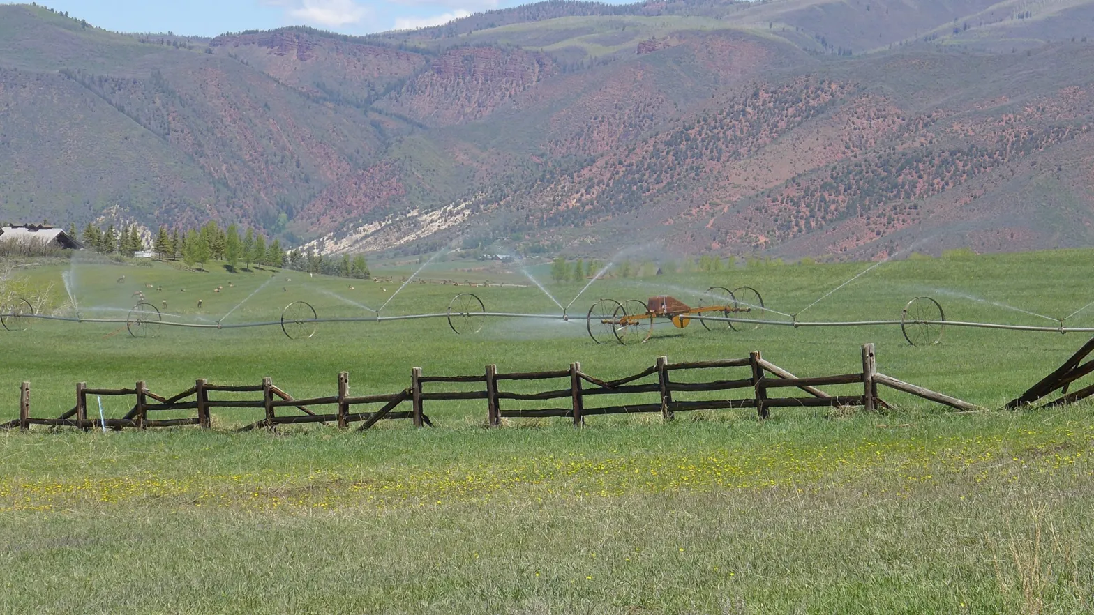
A herd of elk feast on a sprinkler-irrigated meadow in the Starwood subdivision. The area is irrigated with water from Hunter Creek via Red Mountain Ditch.
CREDIT: HEATHER SACKETT/ASPEN JOURNALISM
A Western Slope water conservation district has released a draft of the rules it plans to use to guide a program paying water users to cut back.
The Glenwood Springs-based Colorado River Water Conservation District Board of Directors discussed the policy at its quarterly meeting this week. In December, the Upper Colorado River Commission unveiled details of a rebooted water conservation program, which originally ran from 2015 to 2018 and paid water users to use less Colorado River water.
Along with state officials, it will be up to the River District to approve or deny applications for the restarted program within its 15-county boundary, with the aim of preventing speculation and permanent damage to the Western Slope’s agricultural communities.
“While we didn’t come up with the idea of system conservation and certainly didn’t ever endorse the idea that $125 million should be made available for this particular system conservation program, we recognize that we need to act to protect our communities and our water supply here,” said Andy Mueller, general manager of the River District.
According to the River District’s criteria, an applicant must prove saving water will not injure other water users. In a given year, no more than 30% of the land owned by a single person or entity can be dried up and no more than 30% of the irrigated land in any sub-basin can be dried up.
The policy says that Front Range water providers — which in total take about 500,000 acre-feet of Colorado River water each year across the Continental Divide to growing cities and for agriculture — must also contribute their fair share of water. The River District will only approve contracts so long as there are no new transmountain diversion projects or expansion of an existing TMD project — at all.
“We are not going to ask our water users to cut back when what that means is essentially making room for new transbasin diversions,” Mueller said.
The policy also recommends that if the farm operator is not the owner of the land, that 40% of the federal payments go to the operator.
“Should all the funds go to landowners and not the farm operators, we may see families leave the area or be forced to switch professions,” Mueller said. “That’s a real potential negative of a program like this.”
The restarted System Conservation Pilot Program — which the River District is referring to as just the System Conservation Program, dropping the “pilot” since it’s no longer new — will pay water users a starting price of $150 per acre-foot of saved water. It will be funded with $125 million of federal funding from the Inflation Reduction Act. The deadline to submit applications is Feb. 1 and the UCRC expects to award contracts in March to begin conserving water during the 2023 irrigation season.
The goal of the SCP is to reduce Colorado River water use in the upper basin states (Colorado, Wyoming, Utah and New Mexico) to lessen the impacts of long-term drought and depleted reservoirs. The program is one arm of the UCRC’s 5-Point Plan, released in July, which is aimed at protecting critical elevations at the nation’s two largest reservoirs, Lake Powell and Lake Mead.
Fueled by a two-decade drought and climate change, the reservoirs have fallen to historically low levels, threatening the ability to make hydro-electric power at the dams. Upper basin water managers have called on the lower basin (California, Arizona and Nevada) to bear the brunt of the cuts needed to sustain the system, given that the lower basin regularly uses its full annual appropriation of Colorado River water, while the upper basin uses far less overall.
River District board members will provide feedback on the policy and could approve a final draft at a meeting in two weeks.
The original SCPP saved about 47,000 acre-feet of water at a cost of about $8.6 million over four years. UCRC officials have repeatedly said they cannot put a number on how much water they expect to be conserved in the new iteration of the program.
The UCRC held a webinar on Wednesday [January 15, 2022] to provide additional information to applicants and walk through the review process and timeline. According to UCRC Executive Director Chuck Cullom, the webinar had more than 120 participants.
Cullom said the UCRC, which has just three employees, will be looking to contractors and state leaders to get the program up and running.
“In order to engage in something as regionally diverse as system conservation requires a team,” he said. “So we are engaging with a consultant who will provide technical and administrative support work as well as the leadership and work from each of the four states.”
Aspen Journalism covers water and rivers in collaboration with The Aspen Times.
Map of the Colorado River drainage basin, created using USGS data. By Shannon1 Creative Commons Attribution-Share Alike 4.0
Waterfalls along Yule Creek. CREDIT: COURTESY PHOTO BY JOHN ARMSTRONG
Click the link to read the guest column on the Aspen Times website (Stacy Standley). Here’s an excerpt:
Now is the time to take a giant step into the future with revolutionary ideas that transcend the parochial local interests of the Roaring Fork River Valley by recognizing that climate/weather change, along with population growth, has erased the boundaries of the Colorado River Basin…Aspen is now the pivotal headwaters of the Colorado River Basin, which has become a small, compacted irrigation canal instead of a great river system and has shrunk many hundreds of miles into but a few feet…
1. There should be 100% metering and billing of every drop of water: 7% of the Aspen distribution is unmetered and/or unbilled and unmetered, and this should be eliminated.
2. You can not distribute or control what you do not measure: Metering and billing should be by constant recorded, instantaneous, wifi-linked electronic services on all distribution points and reported to every customer and the Water Department on a instantaneous daily basis, with auto shutoffs for an aberration of usage by 1% or more.
3. All wastewater and storm water must be a fully-integrated part of the treated water-supply system by municipal recycling and/or irrigation and municipal water usage.
4. Downstream water flows that exceed minimum stream flow must be acquired and piped back into the upstream Aspen intake.
5. Aspen and Pitkin County must negotiate with Twin Lakes Canal and Reservoir Co. and the Fry-Ark project to create water savings for their service area and water that can be allowed to stay in the Roaring Fork River Valley.
6. Salvation Ditch, Red Mountain Ditch, and all other local irrigation systems should become a part of the Aspen water conservation and re-use ethic.
7. 100% of all leaks and water waste must be ended immediately.
8. Every tree, plant, and natural out-of-house improvement must be identified and the water usage calculated by Lysimeter and/or other instantaneous soil moisture storage measurement system and then a local research and development lab created to test, grow, and install water conserving plants and systems for out-of-house water management and control.
9. All local streets should be coated with bright reflective surfaces to maintain a cooler urban-heat island and, thus, improve out-of-house water usage.
10. Aspen should create its own bottled (no plastic) water supply for individual use from a high-quality spring and distribute at least 2 gallons per person per day inside of the city service area for drinking water usage at cost to increase the Aspen water supply.
11. Aspen should divert into vertically oriented pipeline coils (24 to 48 inch) in all area streams to capture water runoff that exceeds minimum stream flows and keep the vertical-coiled pipelines at or above the city base elevation for instantaneous “pipeline coil reservoir storage.”
12. Every new or remodeled home and business must have installed an on-site water-storage tank for at least three months of driest in-house water usage.
13. Aspen should participate individually and/or with other Colorado River Basin water users in regional ocean, salt flats, and poor quality oil field wastewater/produced water (i.e., Rangely Field and Utah Basin) purification desalination and urban wastewater recycling for earning water-use credits.
14. Aspen should negotiate with Colorado River Basin Native American tribes to create constructive water savings and water-credit system for the benefit of reservation and also Aspen water usage.
15. Aspen should negotiate to replace Colorado River Basin hydroelectric-power generation with renewable energy to earn water storage credits for regional reservoir.
Click the link to read the article on the KUNC website (Alex Hager). Here’s an excerpt:
“Everybody is so eager to make an early call on this,” said Brad Udall, a water and climate researcher at Colorado State University. “Invariably, you’ll get caught with your pants down if you think you know what’s going to happen.”
Meanwhile, mountain snow totals are off to a promising start. Around Snowmass, the snowpack is 130% above average for this time of the year. The Roaring Fork watershed, which includes Aspen and Snowmass, makes up only 0.5% of the landmass in the Colorado River basin but provides about 10% of its water. In other nearby mountain ranges, snow totals are between 140% and 160% above average. Even if those numbers persist until spring, the severity of the Colorado River’s drought means many more years of heavy snow are needed to make a serious dent.
“It’s great to see a big snowpack,” Udall said. “We would need five or six years at 150% snowpack to refill these reservoirs. And that is extremely unlikely.”
A string of wet years is unlikely because of rising temperatures driven by climate change, Udall said. Since 1970, temperatures in the Colorado River Basin have gone up by three degrees Fahrenheit. Those higher temperatures have already caused a 15% dropoff in streamflows across the region…Warming has driven a raft of worrying environmental changes across the region. In recent years, scientists have sounded the alarm about soils drying out. The ground has become parched and soaks up snowmelt before the water has a chance to reach the places where people divert and collect it. Already, Udall said, winters with 90% of average snowpack have led to springtimes with only 50% runoff because thirsty soil acts like a sponge.
Updated Colorado River 4-Panel plot thru Water Year 2022 showing reservoirs, flows, temperatures and precipitation. All trends are in the wrong direction. Since original 2017 plot, conditions have deteriorated significantly. Brad Udall via Twitter: https://twitter.com/bradudall/status/1593316262041436160
There is a critical connection between clean drinking water and forests. For 80 percent of Coloradans, their water starts in the state’s forests before making its way downstream to their taps.
Given this connection, it is important for Colorado to protect its forested watersheds from the ever-present threat of wildfire to ensure residents and communities have water for drinking, agriculture and other uses. The Colorado Legislature recognizes this need and passed House Bill 22-1379 during the 2022 legislative session to fund projects that reduce wildfire fuels around high-priority watersheds and water infrastructure.
Today, the Colorado State Forest Service announces three projects funded through HB22-1379 that will reduce the risk wildfire poses to water supplies for more than a million Coloradans.
“We are excited to put these funds provided by the legislature to work in high-priority areas where an uncharacteristic wildfire could significantly impact water supplies and infrastructure,” said Weston Toll, watershed program specialist at the CSFS. “All three projects connect to prior fuels reduction work completed by the CSFS and our partners, so we can make an impact on a large scale in our forests.”
The CSFS received $3 million through HB22-1379 to fund forest management in critical watersheds and has allocated $1 million each to three projects in these locations:
Staunton State Park, Colorado. CSFS Photo.
Staunton State Park, Park and Jefferson counties
The project in Staunton State Park will build upon more than 800 acres of prior fuels treatments to reduce the impact a wildfire could have to water resources, communities, outdoor recreation areas and wildlife habitat. Creeks running through the park feed into the North Fork South Platte River, which flows into Strontia Springs Reservoir. Eighty percent of Denver Water’s water supply moves through Strontia Springs Reservoir.
This area, about 6 miles west of Conifer, is noted as a priority for action in assessments by the CSFS, Denver Water, Upper South Platte Partnership, Elk Creek Fire Protection District and in local Community Wildfire Protection Plans. It is also in a focus area for the Rocky Mountain Restoration Initiative.
“This project will allow us to get into areas of the park we haven’t been able to treat yet,” said Staunton State Park Manager Zach Taylor, “to reduce the risk of a wildfire spreading from the park to adjacent neighborhoods. The project also reduces wildfire risk to creeks in the park and the entirety of the drainage.”
Taylor said that the park has worked alongside neighbors in the area, including private landowners and the U.S. Forest Service, to address wildfire fuels since the park was acquired in the 1980s.
“Staunton State Park lies between all of these communities,” he said. “This project could set up the park for the next 5 to 10 years in helping us meet our goals for fuels reduction.”
Teller County, Colorado. CSFS photo.
North Slope of Pikes Peak, Teller County
The project on the North Slope of Pikes Peak will help protect essential drinking water and water infrastructure for the City of Colorado Springs. Reservoirs on the North Slope provide about 15 percent of the city’s drinking water supply. Work there will add to more than 3,500 acres of prior fuels treatments on Colorado Springs Utilities’ municipal lands and fill an important gap in treated areas around North Catamount Reservoir and the headwaters of North Catamount Creek. It will also help protect infrastructure that conveys water from the utility’s Blue River collection system to the reservoir.
The Pikes Peak Watershed is noted as a high priority area in plans by the CSFS, U.S. Forest Service and Colorado Springs Utilities. It is also in a focus area for the Rocky Mountain Restoration Initiative.
“Colorado Springs Utilities’ 34-year-long partnership with the Colorado State Forest Service has enabled many beneficial forest management activities that reduce the risks and impacts of wildfire in and adjacent to our watersheds,” said Jeremy Taylor, forest program manager with Colorado Springs Utilities. “Through the Pikes Peak Good Neighbor Authority (GNA), we’ve expanded this collaboration to include the U.S. Forest Service for cross-boundary work, and we’re now embarking on the Big Blue project on the North Slope of Pikes Peak. It’s a valued partnership that prioritizes working together to improve forest health and protect our water resources, public lands and neighboring private lands.”
Sheep Mountain, Grand County, Colorado. CSFS Photo.
Fraser Valley, Grand County
The project in the Fraser Valley will lower the risk of wildfire to water supplies for Denver and the towns of Fraser and Winter Park by reducing fuels on U.S. Forest Service, Denver Water and private lands. It connects to several prior treatment areas to establish a connected, large-scale fuel break that could allow firefighters to engage a wildfire in the event of a fire. During the William’s Fork Fire in 2020, the project area was identified as where a wildfire could spread into the densely populated Fraser Valley.
The Grand County Wildfire Council identified the project area as a high priority through planning efforts by the CSFS, USFS, Bureau of Land Management, Denver Water, Grand County and local fire departments.
“These projects are critical for watershed health and source water protection for Denver Water and our 1.5 million customers. Healthy forests equal healthy watersheds,” said Christina Burri, watershed scientist with Denver Water. “Denver Water is so grateful for the partnerships and collaboration that make these projects possible.”
The CSFS expects work on these projects to begin in 2023 and will monitor the project work in future years to evaluate its impact and efficacy. All three projects allow the CSFS and its partners to achieve goals and enact strategies identified in the 2020 Colorado Forest Action Plan and are in areas identified as priorities in the plan.
“Governor Polis and the Colorado legislature have made tremendous investments to protect our watersheds from the increasing threat of wildfires and the Colorado State Forest Service is at the forefront in moving these projects forward”, said Dan Gibbs, executive director of the Colorado Department of Natural Resources. “The three projects announced today build on existing efforts to increase resiliency and make impactful investments in key watersheds to create healthier forests and reduce the threat of future wildfires.”
“Thank you to the Colorado Legislature for making the $3 million available for this important work and to our many partners for working alongside the Colorado State Forest Service on these projects,” Toll said. “Together, we are making a landscape-level impact and leveraging our collective resources toward the goal of lowering wildfire risk to water supplies and protecting one of our state’s most precious resources.”
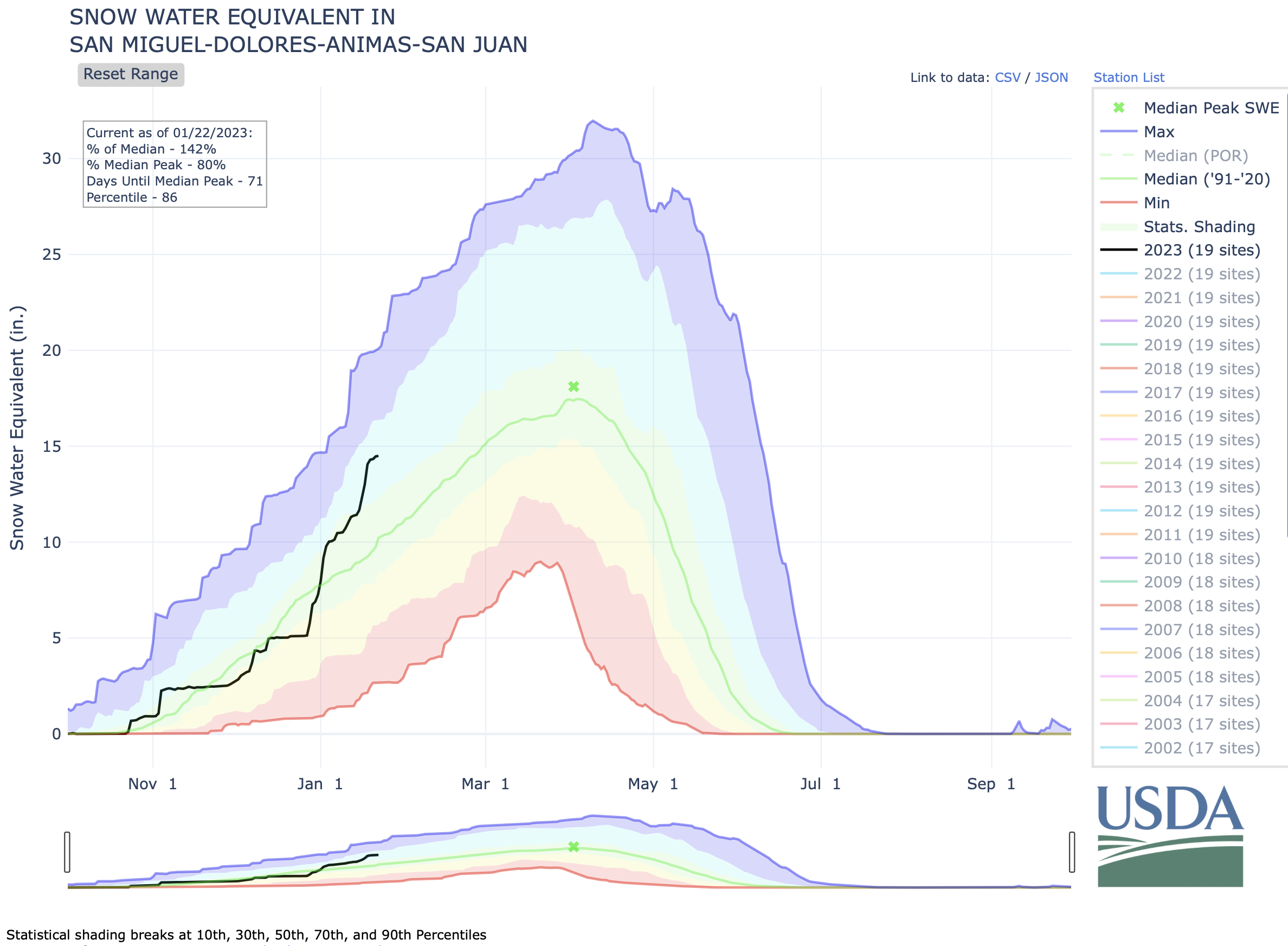
Heavy snows came to Pagosa Country this week, causing Archuleta School District to call snow days on Jan. 17 and 18, among other disruptions. Sites in Archuleta County received between 22.4 and 35.6 inches of snow in the storms be- tween Saturday Jan. 11 and Jan. 18, according to the Community Collaborative Rain Hail and Snow Network website. Snowfall totals varied throughout the county, with the highest amount reported near Village Lake. A report from Wolf Creek Ski Area indicates that Wolf Creek had received 16 inches of snow in the previous 24 hours and 52 inches from the latest storm as of approxi- mately 6 a.m. Jan. 18, bringing the midway snow depth to 106 inches and the year-to-date snowfall total to 219 inches.
According to the U.S. Depart- ment of Agriculture National Water and Climate Center’s snowpack report, the Wolf Creek summit, at 11,000 feet of elevation, had 22.2 inches of snow water equivalent as of 11 a.m. on Wednesday, Jan. 18.
The Wolf Creek summit was at 131 percent of the Jan. 18 snowpack median.
The San Miguel, Dolores, Animas and San Juan river basins were at 152 percent of the Jan. 18 median in terms of snowpack.
Upper Colorado River Basin states, including Wyoming, are looking for agricultural irrigators, municipalities and other water users interested in a volunteer program that pays them to leave water in streams flowing to the troubled Colorado River.
But with just two weeks left to enroll in the System Conservation Pilot Program, water users still have myriad questions regarding eligibility, how water savings are measured and what participation in the program might mean to their operations.
Given the short timeframe, the Upper Colorado River Commission, and the Wyoming State Engineer’s Office, which oversees the program in Wyoming, are urging interested water users to submit project proposals by the Feb. 1 deadline, even if they’re unsure whether their water savings plans qualify.
“We can still take incomplete applications by Feb. 1, and we’ll work with you to complete those, finalize them and get you into the system,” UCRC Deputy Director Sara Larsen said during a public question-and-answer webinar Wednesday.
The UCRC staff, along with state-level water officials, will verify qualifications and otherwise help applicants complete their proposals — post-submission, if necessary — in order to enroll as many participants as possible, according to the commission.
Successful applicants for the 2023 program will be notified by the end of February.
Water conservation rush
The SCPP is one of five short-term strategies that Upper Colorado River Basin states — Wyoming, Colorado, Utah and New Mexico — have offered to help meet a challenge by federal officials to conserve 2 million to 4 million acre-feet of water in the over-taxed system this year.
The UCRC announced a call for SCPP proposals Dec. 14 with a filing deadline of Feb. 1.
Lake Powell, just upstream from Glen Canyon Dam. At the time of this photo, in May 2021, Lake Powell was 34% full. (Ted Wood/The Water Desk)
The quick turn-around stems from intensifying drought conditions that helped drain Lake Powell and Lake Mead — the two largest reservoirs on the Colorado River — to historic lows this past summer, threatening water availability for some 40 million people who depend on the river. Interior Department Assistant Secretary for Water and Science Tanya Trujillo announced drought response actions in May intended to maintain hydropower generation at Powell and Mead, which included taking extra releases from Flaming Gorge Reservoir on the Wyoming-Utah border.
“More needs to be done as the system reaches critically low water levels,” Trujillo testified before the U.S. Senate Committee on Energy and Natural Resources in June. “The system is at a tipping point.”
Though Wyoming and its upper basin partners didn’t commit specific water-saving volumes in response to the Interior Department’s call for conserving 2 million to 4 million acre-feet of water this year, the UCRC put forth a 5-point plan. The SCPP is the first to be implemented.
This diagram shows water levels among major reservoirs in the Upper Colorado River Basin as of Jan. 17, 2023. (Bureau of Reclamation)
“Upper [Colorado River Basin] states have made no commitment with regard to the number of [SCPP] projects or target volumes or anything other than adapting to the interest from willing partners among water users and tribes in the upper basin,” UCRC Executive Director Chuck Collum said during the Wednesday webinar.
Addressing the short turn-around for SCPP proposals, applications don’t “have to be perfect,” Collum said. “But it needs to be in the hopper [by Feb. 1] so we can work with you to refine it.”
The UCRC and Wyoming State Engineer’s Office, however, are not beginning from square one. Wyoming enrolled a couple dozen water users in the program’s initial iteration from 2015 through 2018, and found exponential interest among irrigators — particularly in the upper reaches of the Green River and its tributaries, according to state officials.
Yampa River Basin via Wikimedia.
How it works
To qualify for the SPCC in Wyoming, a water user must have a valid water right within the Little Snake or Green River basins and demonstrate that that right has been exercised in recent years, according to state officials. Participants are credited only for voluntary reductions of “consumptive use,” which is described as Colorado River-bound water “that can be estimated or measured,” according to the UCRC.
Flaming Gorge Reservoir, which receives water draining off 15,000 square miles of western Wyoming, was more than 30 feet below its maximum height in this December 2022 image. (Mike Koshmrl/WyoFile)
In the case of industrial and municipal water users, consumptive use is generally measured by determining how much water is diverted and not returned to the river system. Water reuse and recycling may qualify, however, according to the UCRC. For agricultural irrigation operations, consumptive use, generally, is measured by determining how much diverted water is consumed by crops.
For example, an irrigator might divert 10 acre-feet of water but 2 acre-feet returns to the system. Water officials would credit the irrigator for volumes of water allowed to flow downstream that would otherwise normally have been consumed.
For now, the UCRC envisions a “fixed term” compensation of $150 per acre-foot of water under the SCPP in 2023, although it may consider higher rates based on circumstances, according to the agency’s request for proposals. The UCRC secured $125 million from the Inflation Reduction Act to support the program — an amount that water officials say is more than enough to cover payments and expenses in 2023.
In the first iteration of the SCPP — from 2015 through 2018 — a total 23,886 acre-feet of water was conserved among 26 projects in Wyoming, according to a report by the upper basin commission. It paid water users a total $4,079,233 — about $171 per-acre foot.
Priority for SCPP proposals in 2023 will be given to “projects that are likely to mitigate impacts of the ongoing drought,” larger volumes of water to be conserved and the ability to verify water savings, according to the request for proposals.
Further details about how the program works in Wyoming and what qualifies can be found on the Colorado River Working Group’s website.
Ansel Adams The Tetons and the Snake River (1942) Grand Teton National Park, Wyoming. National Archives and Records Administration, Records of the National Park Service. (79-AAG-1). By Ansel Adams – This tag does not indicate the copyright status of the attached work. A normal copyright tag is still required. See Commons:Licensing., Public Domain, https://commons.wikimedia.org/w/index.php?curid=118192
The 1956 Colorado River Storage Project Act has had a significant impact on the development and management of water in the Upper Colorado River Basin. The 1956 act authorized construction of the Colorado River Storage Project (CRSP) which allowed for comprehensive development of the water resources of the Upper Basin states (Colorado, New Mexico, Utah, and Wyoming) by providing for long-term regulatory storage of water for purposes including, regulating the Colorado River, storing water for beneficial use, allowing Upper Basin States to utilize their Colorado River Compact apportionments, providing for the reclamation of arid lands, control of floods and generation of hydroelectric power. The Colorado River Storage Project is one of the most complex and extensive river resource developments in the world.
There are four initial storage units built as part of the CRSP:
and a number participating projects (16 of which have been completed or are in process of completion). The purposes of the CRSP identified in the 1956 act include regulating the flow of the Colorado River, storing water for beneficial consumptive use, providing for reclamation of arid and semi-arid lands, providing flood control, and generating hydropower. The CRSP also provides for recreation and improves conditions for fish and wildlife.
During the 1960’s and 1970’s, public concern over the environment resulted in new federal environmental laws. The enactment of the 1969 National Environmental Policy Act, the 1973 Endangered Species Act, and the 1992 Grand Canyon Protection Act outlined new requirements for the protection and enhancement of fish, wildlife, and the environment. Administration of these laws has modified the operation of CRSP facilities.
The dams of the CRSP main storage units have a combined live storage capacity of 30.6 million acre-feet and power generation capabilities to provide over five billion kilowatt-hours of energy annually. Glen Canyon Dam is the largest of the CRSP facilities and is the key unit for controlling water releases to the Lower Basin. In 1970, the Criteria for Coordinated Long-Range Operation of Colorado River Reservoirs (Operating Criteria) was established to provide for the coordinated operation of reservoirs in the Upper and Lower basins and set conditions for water releases from Lake Powell and Lake Mead. In accordance with the Operating Criteria, an objective release of 8.23 million acre-feet per year is targeted for downstream delivery.
The multipurpose CRSP has not only been integral to the development of the arid West, it has also played a vital sustaining role through extended periods of drought. The many benefits provided by the CRSP are essential to life in the West today.
Morrow Point Dam, on the Gunnison River. Photo: Brent Gardner-Smith/Aspen JournalismView below Flaming Gorge Dam from the Green River, eastern Utah. Photo credit: USGSNavajo Dam. Photo credit: ReclamationCrystal dam spilling May 2009Blue Mesa Dam. Photo credit: Reclamation
Water users are urgently trying to keep Lake Powell on the Utah-Arizona border from dropping to a point where Glen Canyon Dam can no longer generate electricity. (Source: Bureau of Reclamation)
A Colorado nonprofit is one of three winners of the national Colorado River Basin Water Scarcity Challenge, a philanthropic initiative to spur creative solutions to water shortages in the crisis-ridden, seven-state Colorado River system.
The Denver-based Colorado Water Trust will spend the next year working with Quantified Ventures developing new models for securing funds and identifying valuable water rights that can be used to help restore riparian areas, aid streams and maintain agricultural water uses.
Founded in 2002, the Colorado Water Trust partners with existing entities, such as the Colorado Water Conservation Board, as well as environmental and farm groups, to acquire or lease water rights, keeping that water in the streams to stretch the amount of water available for fish and the environment, irrigators and industry even during dry times.
Quantified Ventures is a finance and consulting company that specializes in developing sustainable solutions to environmental problems.
Across the American West, water users, government agencies, regulators and environmental groups are scrambling to find ways to save the river. Crippled by a megadrought thought to be the worst in 1,200 years, and shifts in climate that are reducing the mountain snows on which it relies, the river system is on the brink of collapse.
The Colorado River Basin Scarcity Challenge is funded by a $500,000 donation from the Gates Family Foundation and the Walton Family Foundation, according to Quantified Ventures spokesman Matt Lindsay. [Editor’s note: Fresh Water News is an initiative of Water Education Colorado which receives support from the Gates and Walton foundations.] Winners were announced Jan. 12.
“The Colorado River is facing an unprecedented crisis that requires innovative thinking and investment at an equally historic scale,” said Morgan Snyder, in a prepared statement. Snyder is senior program officer for the Walton Family Foundation Environment Program. “Projects like these that move past outdated systems and instead find new ways to conserve, adapt, and become more resilient are essential to ensure a sustainable water supply for the millions who depend on the river.”
Kate Ryan, a senior attorney at the Colorado Water Trust, said winning the scarcity challenge will help her organization develop new relationships in the finance world and find ways to move more quickly in an arena in which deals can take years to finalize, allowing the water trust to accomplish more.
“This will allow us to become more nimble and potentially to meet new investors,” Ryan said. “We will also be looking at strategies for using water for additional sources of revenue, such as remarketing it downstream in a way that is complementary to our project partners. It will also help us recoup investment and turn that into operating revenue, or for funding new acquisitions or leases of water.”
The Tucson, Arizona-based Watershed Management Group is another winner. The Watershed Management Group will work with Quantified Ventures to develop new “green” infrastructure to improve the health of Tucson’s groundwater system, among other projects, with the goal of using less Colorado River water, according to Watershed Management Group’s Catlow Shipek.
“Our goal is to build hydro local resilience to reduce our dependence on Colorado River supplies,” Shipek said. “The idea is how do we restore our watershed but not at the expense of another watershed.”
The third winner, Ndrip, will use Quantified Ventures to evaluate how to increase the scale of its drip irrigation systems on tribal lands throughout the Colorado River Basin. Unlike other drip irrigation systems, Ndrip uses existing water distribution systems on farms and is gravity-based. These features help offset the high capital costs of more traditional drip irrigation systems, according to Ndrip’s website.
Ndrip, which has offices in Australia, Israel, South Africa and the U.S., could not be reached for comment.
Each of the scarcity challenge winners will spend roughly the next year with Quantified Ventures developing new solutions that will help improve the sustainability of the Colorado River system.
Jerd Smith is editor of Fresh Water News. She can be reached at 720-398-6474, via email at jerd@wateredco.org or @jerd_smith.
On July 7, 2020, we closed our headgate that takes water from the Little Cimarron for irrigation. The water in the above photo will now bypass our headgate and return to the river. Photo via the Colorado Water Trust.
Volunteers learn how to measure how much water is contained in the snowpack, known as snow-water equivalent (SWE) at the SNOTEL site at the top of McClure Pass in March 2018. Water managers are gaining a better understanding that what happens in the weeks after peak snowpack in the spring can have an outsize influence on the year’s water supply. CREDIT: HEATHER SACKETT/ASPEN JOURNALISM
Water managers in the Colorado River basin are gaining a better understanding that what happens in the weeks after peak snowpack — not just how much snow accumulated over the winter — can have an outsize influence on the year’s water supply.
Water year 2021 was historically bad, with an upper basin snowpack that peaked around 90% of average but translated to only 36% of average runoff into Lake Powell, according to the U.S. Bureau of Reclamation. It was the second-worst runoff on record after 2002. One of the culprits was exceptionally thirsty soils from 2020’s hot and dry summer and fall, which soaked up snowmelt before runoff made it to streams. But those dry soils are only part of the story.
A new paper from the Desert Research Institute, a nonprofit science arm of the Nevada university system, found that heat waves in April 2021 drove record snowmelt rates at about 25% of snow-telemetry (SNOTEL) sites looked at across the West. SNOTEL is a network of remote sensing stations throughout the West’s mountainous watersheds that collect weather and snowpack information.
A heat wave that was concentrated over the Rocky Mountains on April 1-7 contributed to record snowmelt at 74 stations, including areas that feed the Colorado River.
A few different agencies release monthly water-supply forecasts for April through July, including the National Resource Conservation Service, the Bureau of Reclamation and the Colorado Basin River Forecast Center. The April forecast is the first prediction of how streamflows will shape up for the year.
But according to the paper, in 2021, “rates of snowmelt throughout April were alarming and quickly worsened summer runoff outlooks which underscores that 1 April may no longer be a reliable benchmark for western water supply.”
The paper did not quantify what exactly the record melt speed meant for water supply, but paper author and associate research professor of climatology Dan McEvoy said it definitely contributed to the poor inflow into the nation’s second-largest reservoir in 2021. It also shows there are many more factors relevant to predicting the water supply than just how much water is in the snowpack, a metric known as snow-water equivalent (SWE), which is measured by SNOTEL sites.
“There was a combination of things that was contributing to this really low runoff in places like the Colorado River basin,” McEvoy said.
Some of these other factors include very little April precipitation and warm nighttime temperatures, which didn’t allow the snowpack to get into the daily freeze-thaw cycle that’s common in the spring. Persistent high pressure kept skies clear and sunny, which meant that more of the snowpack sublimated, evaporating instead of turning into liquid.
“When it’s sunnier and warmer, you can lose some of that water directly to the atmosphere,” McEvoy said. “It doesn’t even get to melt and go into the runoff.”
These rapid melting events could also help set up prime conditions for wildfires, he said, something he wants to continue studying.
“When you have the snow disappear earlier there’s more time with the ground exposed, which contributes to drying out the vegetation in the spring and summer and an earlier onset to wildfire season,” McEvoy said.
After peak snowpack
Climatologists at Colorado State University are working on a similar study that looks at how factors such as precipitation after peak snowpack affect spring runoff. Their findings underscore how important the conditions of the six to eight weeks after peak snowpack are for predicting streamflows.
“One of the things we found that was crystal clear from the study was that one of the major sources of water-supply forecast error is what happens after peak snowpack,” said Peter Bennett Goble, a climatologist at CSU who is working on the study. “Just knowing how much uncertainty is still out there on April 1 or even April 15 probably allows water managers to be a little more cautious, maybe hold a little bit more back, especially if it looks like it’s going to be an early runoff.”
Predicting whether reservoirs will fill — and therefore how much water to release to make room for the inflow — can be tricky. Some municipal water providers use the Colorado Airborne Snow Measurement Program — with its lidar-equipped planes — to more accurately measure snowpack. For example, Denver Water has used CASM to see how much snow is in the headwaters of the Blue River basin, which feeds Dillon Reservoir, its largest storage bucket.
But aside from this technology, which is expensive and not yet available everywhere, water managers rely heavily on data from the SNOTEL sites to make streamflow forecasts. This method has limitations, providing just a snapshot of conditions at one location.
These limitations can be seen in recent years’ forecasts for Ruedi Reservoir, on the Fryingpan River. Initial forecasts in April 2021 projected Ruedi could probably fill to its entire 102,373-acre-foot capacity, but the reservoir ended up only about 80% full that year. In 2020, each of the three main forecasting agencies also overpredicted Ruedi inflow for the months of April, May and June. (An acre-foot covers 1 acre to a depth of 1 foot.)
Tim Miller, a hydrologist with the U.S. Bureau of Reclamation who manages operations at Ruedi, said his models predicted a 2021 Ruedi inflow of 111,000 acre-feet, but only 77,000 acre-feet actually flowed in. That the models are based on historical SNOTEL data from past decades is a drawback as climate change progresses, but it’s the best we have, Miller said.
“It makes the assumption that what we have seen in the past is what we will see in the future, which is a really poor assumption when you’re in the middle of a change in the climate,” Miller said. “We will probably see events like we haven’t seen in the future and we are using what we’ve seen to predict them.”
Dave Kanzer, director of science and interstate matters for the Glenwood Springs-based Colorado River Water Conservation District, said people often look for a single explanation when streamflows don’t match predictions. The River District owns and operates Wolford Mountain Reservoir, near Kremmling, and stores water in Ruedi Reservoir. But there is often a whole host of compounding factors that water managers will have to begin weighing more heavily as the climate warms.
“It’s not just about soil moisture, it’s not just about solar radiation, it’s not just about temperatures, it’s not just about the winds — it’s everything,” Kanzer said. “In some cases, like 2021, you get what some people like to call the perfect storm.”
Aspen Journalism covers water and rivers in collaboration with The Aspen Times.
…welcome to the Imperial Valley. Wedged in California’s southeastern corner, it’s one of the most important places you’ve probably never been. To one side of [Ralph] Strahm’s farm is the Sonoran Desert at its most stark, where creosote-studded washes give way to glimmering sand dunes and craggy mountain peaks. To the other side is an astonishingly productive agricultural empire. Nearly half a million acres of lush green fields sprawl into the distance, popping out lettuce, sugar beets, onions, cattle feed and more…
But keeping the vegetable aisle stocked comes at a cost. Imperial County farm barons use more Colorado River water than the rest of California combined. And as the planet heats up, there’s less and less water to go around…
Clean energy advocates see Imperial as an ideal place for solar farms and battery projects that can help solve the American West’s energy and water crises. The land is flat; the sunlight, abundant. The Colorado River desperately needs relief. And Imperial is one of California’s poorest counties,its agriculture-heavy economy practically crying out for diversification and higher-paying jobs But resistance to change runs deep, particularly among the few hundred families who own all the farmland. Agriculture is the only way of life many of them have known, and they’re raring to defend it. Their ancestors settled here a century ago, staking an early claim to the Colorado and carving canals to carry its riches through the desert. Again and again, they’ve faced pressure to sell water to coastal cities. They’re ready to pounce on anything that smells like a water grab. And to some of them, solar power smells like a water grab…
Lurking beneath these battles are urgent questions with no easy answers: What is the land’s best use? Who gets to decide? And how do we balance water conservation, food production and clean power generation in an era of climate emergency?
A solar farm off CO 17 in Alamosa County. The San Luis Valley produces 10 percent more power per solar panel than anywhere else in the state due to its base elevation of 7,500 feet and more days of sun than the Front Range and anywhere else in Colorado. Photo by Owen Woods via The Alamosa Citizen
Years of consideration and conservation work all led to a golden moment for two pristine rivers in central Colorado.
During its meeting Jan. 18 in Colorado Springs, the Colorado Parks and Wildlife Commission welcomed the Gunnison and Taylor Rivers as the newest Gold Medal trout fisheries in the state. CPW’s Gold Medal Program showcases the most elite fisheries throughout the state.
The stretches nominated and approved include 20 miles of the Taylor River below Taylor Park Reservoir and 12.5 miles of the Gunnison River starting west of the town of Gunnison at Twin Bridges extending up to the town of Almont.
“I’m pretty excited to be able to announce these two waters into our Gold Medal Program,” said CPW Assistant Aquatic Section Manager Josh Nehring. “It’s an achievement that came about by a lot of work by a lot of people over a number of decades. It’s amazing to see the quality of fisheries that we have here.”
Fisheries in Colorado may be designated by CPW as “Gold Medal” if they meet two qualifying criteria. The standard is 60 pounds of fish per acre along with at least 12 quality trout of 14 inches or greater per acre.
With the addition of the Gunnison and Taylor Rivers, Colorado now boasts 19 Gold Medal sections on 13 rivers that total roughly 362 miles. The state also has three lakes that have earned Gold Medal designation.
While the Gunnison and Taylor are newly-designated Gold Medal streams, CPW aquatic biologists believe the rivers have produced Gold Medal quality trout fishing since the 1990s.
CPW Aquatic Biologist Dan Brauch said that while the rivers had met the biological criteria for designation for decades, it was important to ensure the streams provided long-lasting fish habitat for all life stages of trout.
“Significant work went into maintaining conditions on the Gunnison and Taylor Rivers to allow those fisheries to continue to persist,” Brauch said. “We have sampled the rivers quite a few times in the last 10 years, and we continued to see good numbers of quality-size trout and abundant trout.
“The Gunnison and Taylor Rivers really represent a successful conservation story with lots of partners that have made this fishery what it is today.”
CPW surveys streams regularly through the process of electrofishing. Fish are collected, weighed, measured and returned to the water. Data collected through these surveys provides invaluable data for CPW to assess the health of a fishery and to determine waters worthy of Gold Medal nomination.
“It does take quite a bit of work to get fisheries to this standpoint,” said Nehring, who grew up in neighboring Montrose and has enjoyed fishing the two rivers since he was a child. “Just the habitat that goes into it, the monitoring of the fisheries, making sure our regulations are appropriate and we aren’t getting too many fish harvested. There are a lot of things that go into making sure the system is healthy.”
Brauch and Nehring thanked a multitude of public and private partners that have come together throughout time to support the Gunnison and Taylor fisheries as work has been done to improve and protect trout habitat through the Gold Medal stretches.
While celebrating the conservation success story that has led to Gold Medal status for the rivers, CPW Area Wildlife Manager Brandon Diamond encouraged anglers to help protect these resources for generations to come.
“It’s extremely important right now for all water users and conservation-minded people, including anglers, to view these incredible resources through a stewardship lens,” Diamond said. “And I strongly encourage all of us to evaluate how we can contribute to the long-term conservation of these waters and how we fit in as stewards of the land and river resources.
“The Gold Medal designation is certainly something we are locally proud of. The Gunnison Valley has always been very supportive of wildlife conservation values, and we hope to continue that relationship moving forward.”
Photo credit: Colorado Parks & WildlifePhoto credit: Colorado Parks & WildlifePhoto credit: Colorado Parks & WildlifePhoto credit: Colorado Parks & WildlifePhoto credit: Colorado Parks & Wildlife
Some living here amid the cactus and creosote bushes see themselves as the first domino to fall as the Colorado River tips further into crisis. On Jan. 1, the city of Scottsdale, which gets the majority of its water from the Colorado River, cut off Rio Verde Foothills from the municipal water supply that it has relied on for decades. The result is a disorienting and frightening lack of certainty about how residents will find enough water as their tanks run down in coming weeks, with a bitter political feud impacting possible solutions.
The city’s decision — and the failure to find a dependable alternative — has forced water haulers like [John] Hornewer to scour distant towns for any available gallons. About a quarter of the homes in Rio Verde Foothills, a checkerboard of one-acre lots linked by dirt roads in an unincorporated part of Maricopa County, rely on water from a municipal pipe hauled by trucks. Since the cutoff, their water prices have nearly tripled. The others have wells, though many of these have gone dry as the water table has fallen by hundreds of feet in some places after years of drought [ed. and over pumping]…
This grim [Colorado River] forecast prompted Scottsdale to warn Rio Verde Foothills more than a year ago that their water supply would be cut off. City officials stressed their priority was to their own residents and cast Rio Verde Foothills as a boomtown of irresponsible development, fed by noisy water trucks rumbling over city streets. “The city cannot be responsible for the water needs of a separate community especially given its unlimited and unregulated growth,” the city manager’s office wrote in December…Scottsdale Mayor David Ortega was unmoved when his Rio Verde Foothills neighbors cried foul.
“There is no Santa Claus,” he said in a statement last month. “The megadrought tells us all — water is not a compassion game.”
For the past several years, some residents have sought to form their own water district that would allow the community to buy water from elsewhere in the state and import what they need, more than 100 acre-feet of water per year. Another group prefers enlisting a Canadian private utility company, Epcor, to supply the community, as it does with neighboring areas. But political disputes have so far foiled both approaches. The water district plan — which supporters say would give them long-term access to a reliable source of water — was rejected in August by the Maricopa County supervisors. The supervisor for the area, Thomas Galvin, said he opposed adding a new layer of government to a community that prizes its freedom, particularly one run by neighbors with the authority to condemn property to build infrastructure. [Thomas] Galvin preferred Epcor, a utility that, if approved, would be regulated by the Arizona Corporation Commission.
When it comes to supplying water to 1.5 million people, the spring runoff is the most important time of the year for Denver Water.
That’s why having good information about the snowpack is critical. Mountain snow is Denver Water’s primary source of water for its customers.
When the snow that piles up in the mountains over the winter starts to melt, the water flows into rivers and streams that fill storage reservoirs. The spring runoff typically starts at the end of April and wraps up in late June or early July.
But the work to count the snowflakes starts long before that.
“We keep track of the snowpack through measurements on the ground, from the sky and from automated sensors,” said Nathan Elder, water supply manager at Denver Water. “We monitor the snow all winter because it constitutes the majority of our water supply and has major impacts on how we operate.”
In 2022, the snowpack peaked below average in the areas where Denver Water catches the snowmelt. A below-average snowpack affects the amount of water available to capture and store in the spring.
Denver Water’s collection system via the USACE EIS
“We would like to completely fill our reservoir system every runoff season,” said Elder. “In the years when we don’t hit that mark, it makes following the utility’s annual summer watering rules even more critical for the Denver metro area.”
Watering two days a week should be enough for most landscapes for most of the summer. (Only water a third day, if needed, during periods of extreme heat or dryness.)
Following the summer watering rules will help keep reservoir levels higher, in case next winter’s snowpack is below average.
The Fraser River south of Winter Park on April 29, 2022. The snowpack in the areas where Denver Water captures snowmelt peaked below average for the 2021-2022 winter season. Photo credit: Denver Water.
The snowpack data, reservoir forecasts and customer water use are some of the key factors used to determine if Denver Water might need to impose additional watering restrictions beyond the regular summer watering rules, which run from May 1 through Oct. 1.
Here’s a closer look at the primary ways Denver Water’s planning team keeps track of Colorado’s snowpack.
Four times a year from January through April, Denver Water crews strap on boots and snowshoes and sometimes ride snowcats to trek into the forest to measure the snow in Grand, Park and Summit counties, the primary areas where the utility collects its water supply for customers in metro Denver.
Each journey follows a specific, predetermined route called a snow course.
Each snow course has 10 designated stops where workers jab a hollow tube into the snow to capture and weigh a sample of the snowpack.
At each stop, the crew conducts a four-step process:
Collect a sample by dropping the pole into the snow until it hits the ground.
Measure the depth of snow in the tube.
Get the weight of the snow by weighing the snow-filled tube and subtracting the weight of the empty tube.
Calculate the density of the snow using the depth and weight measurements.
Using these measurements, crews calculate the snow water equivalent, or SWE, to determine the water content.
For example, if 10 inches of snow has a density of 10%, the snow water equivalent — the amount of water left behind if those 10 inches of snow melted — is 1 inch of water.
Rob Krueger, facility supervisor for Denver Water, uses a specially designed hollow tube to collect a snow sample near Berthoud Pass. Photo credit: Denver Water.
Denver Water shares the data collected on each snow course with the National Resources Conservation Service, or NRCS. Denver Water is one of 15 agencies that sends people out to collect snow data at 95 locations across Colorado in partnership with the NRCS.
The information helps the agency develop water supply forecasts and monitor snowpack trends over time.
The NRCS’s forecasts are used by water provides, dam operators, farmers, ranchers, recreationists and communities to make important decisions about their water supply.
Denver Water’s Rob Krueger (left) and Adam Clark work out of the utility’s Moffat Collection System office in Winter Park. Here they are weighing a snow sample to calculate how much water it contains. Photo credit: Denver Water.
Silent sentries
Along with data collected by hand, Denver Water uses information from snow telemetry sites, or SNOTEL, sites during the winter.
SNOTELs, basically automated backcountry weather stations, were first installed in the 1970s and are operated by the NRCS. The federal agency currently has more than 900 SNOTEL sites collecting data in remote, high-elevation mountain watersheds across the western U.S.
At each site, a bladder about the size of a queen-sized waterbed and filled with antifreeze monitors and reports the weight of the snow falling on it, providing information about the water content frozen in the snow. SNOTEL sites send data multiple times per day, although some sensors report hourly.
Denver Water uses information from 13 SNOTELs located in its 4,000 square miles of watershed.
A SNOTEL site on Berthoud Pass in Grand County captures snow measurements throughout the winter. The National Resources Conservation Service manages the SNOTEL sites, which transmit information daily. There are over 900 automated SNOTEL sites across the western U.S. Photo credit: Denver Water.
From the air
Starting in 2019, Denver Water began getting data about the snowpack from the air, using Airborne Snow Observatory planes stuffed with high-tech equipment flying over the snow-covered mountains.
The plane uses beams of light to measure the depth of the snow fields below and capture reflections from the frozen surface. The equipment pings the snow’s surface at up to 10 locations every square meter, and powerful computers crunch reams of data.
The flights provide an assessment of the amount of water frozen in place in the snow across hundreds of square miles that is more accurate than anything Denver Water has ever had before.
“The data we get from the Airborne Snow Observatory flights quantifies all of the snowpack in river basin below, rather than trying to build a picture of the snowpack in basin using just a few selected point measurements we get from the SNOTELs and the snow courses,” said Nathan Elder, Denver Water’s manager of water supply. “Imagine trying to watch a high-definition TV that only has 10 of its thousands of pixels working; you just don’t get the whole picture.”
And in the face of increasingly variable weather patterns related to climate change, having better information and more accurate forecasts of the seasonal runoff will be more important in the future, he said.
The view from an Airborne Snow Observatory plane as it flies over a mountainous region to capture data on the snowpack. Photo credit: Airborne Snow Observatories Inc.
Putting it all together
Elder’s planning team uses data from the snow-measuring methods and combines it with other data such as soil conditions and weather forecasts to determine how much water the winter snowpack will send into Denver Water’s reservoirs.
“Having people hike into the forests to measure the snow by hand is very important for water planners because they give us the ‘boots-on-the-ground’ information we use to verify the data we get from the machines in the SNOTELs and the Airborne Snow Observatory flights,” Elder said.
The forecasts — in turn — help determine how Denver Water will manage the water stored in its reservoirs to meet customer demands in the city and determine if additional water restrictions are needed.
The water supply forecasts are also used to provide information to communities, businesses and other water managers about flooding concerns, water levels for boating on reservoirs, maximizing water rights and how to manage water supplies to benefit the environment.
“Managing water is a very complex business,” Elder said. “The more information and data we can get, the better decisions we can make.”
Lees Ferry streamgage and cableway on the Colorado River, Arizona. The point where the upper and lower Colorado River basins divide the river. (Public domain.)
Click the link to read the article on The Denver Post website (Nick Caltrain). Here’s an excerpt:
Colorado’s attorney general is seeking to reinforce his office’s water-focused legal team so it could be prepared for upcoming fights over the Colorado River. Attorney General Phil Weiser, who was just re-elected to a second term, said his office needs to be prepared for litigation or negotiation with other stakeholders to defend Colorado’s water rights. He’s not asking for an overhaul of the office — his ask to the Joint Budget Committee is for two new positions, and water and natural resources make up an overall small percentage of his office’s total budget — but he noted that “the challenges with water are heating up.”
“The era of the lower basin states taking as much water as they wanted — up to 10 million acre-feet when they’re only entitled 7.5 — is over,” Weiser said recently…
Ideas on bolstering the water supply — or at least not drinking too deep from it — vary. Weiser said his focus is on protecting the state’s share. Lawmakers have said water will be a “centerpiece” of this legislative session. House Speaker Julie McCluskie, a Democrat from Dillon, has also singled out lower basin states for overusing their allotment. Weiser noted the strain on the reservoirs and the pressure that puts on water users up and down the river. Navigating the legal rapids will require negotiation or litigation, he said.
“We’ve got to be prepared for either way,” Weiser told reporters after his investiture ceremony Thursday. “We are not going to be afraid to litigate and protect our rights, and as we can find collaborative solutions, we’ll work hard to do that.”
[…]
If lawmakers approve the request this spring for more water specialists, it would bring the department’s total staff working on interstate water issues to 11, including eight attorneys, according to budget documents. The internal team has already won legal victories against other states and the federal government, as well as saved the state money on outside experts, according to the proposal.
Blue Mesa Reservoir is the largest storage facility in Colorado in the Upper Colorado River system. Prolonged drought and downriver demand is shrinking the reservoir. Credit: Tom Wood, Water Desk
From email from Reclamation (Erik Knight):
The next Aspinall Operations meeting is scheduled for this Thursday, January 19th, start time 1:00pm
The meeting will be open to in-person attendance at the Western Colorado Area Office in Grand Junction.
445 West Gunnison Ave
Grand Junction, CO
The meeting will also be available to attend virtually via Microsoft Teams. Please click on this link to attend the meeting virtually.
This link should open in any smartphone, tablet, or computer browser, and does not require a Microsoft account.
The meeting agenda with handouts will be emailed out prior to the meeting.
For any questions please email or call at the number below.
Members of the public packed the Sublette County Public Library in Pinedale Sept. 27, 2022 for a water meeting organized by the Wyoming State Engineer’s Office. (Dustin Bleizeffer/WyoFile)
Members of a working group created by Gov. Mark Gordon to “disseminate information” and “act as a sounding board for the public and stakeholders” regarding Colorado River Compact issues reported Monday mounting public frustration about access to information.
The Colorado River Working Group, formed in 2021, essentially acts as a consulting body and communications conduit between water users in the Green River and Little Snake River basins and the State Engineer’s Office.
At a meeting of the group on Monday members said constituents are confused. Members also reported fielding complaints from stakeholders who can’t get the information they need to stay abreast of the fast-moving and complex topic that stands to impact water users in the state.
At the same meeting, State Engineer Brandon Gebhart insisted the body isn’t subject to the state’s open meetings laws and said he’s hesitant to take questions from the public during working group meetings. Though Monday’s meeting was open to the public — as were six previous meetings — none have been live-streamed or otherwise made available to anyone not in attendance, according to the engineer’s office.
That’s by design, according to Gebhart.
“I’m a little concerned that if we start one of these [live-streamed presentations] that we wouldn’t get through any of the topics before the questions start coming in,” Gebhart told working group members. In a follow-up with WyoFile Tuesday, Gebhart added, “My general concern about doing public webinars is being unable to get through the numerous and complex topics we need to cover if we get slowed down by multiple public questions.”
Chris Brown of the Wyoming Attorney General’s Office discusses the implications of the Colorado River Compact with water users in Pinedale Sept. 27, 2022. (Dustin Bleizeffer/WyoFile)
The working group’s meetings are intended to hash out information and discuss how to disseminate it with water users, Gebhart said. The group’s outreach is primarily done directly between the group’s members and their constituents.
Though there was no formal call for public comments or questions at the Monday meeting, members of the working group, SEO and the attorney general’s office did field some questions from members of the public in attendance.
Under pressure
The main topic of discussion Monday was how the SEO is scrambling to entice eligible water users to take part in a conservation program that pays them to voluntarily leave water in streams that flow to the Colorado River.
Explaining the program and eligibility requirements to myriad water users is complicated, particularly as many in the ag community are leery of government-sponsored programs aimed at reducing water use, according to the SEO. A tight timeframe makes the effort more challenging. The Upper Colorado River Commissionannounced a call for System Conservation Pilot Program proposals Dec. 14 with a filing deadline of Feb. 1.
The SEO, which is overseeing the program in Wyoming, is eager to enroll as many participants as possible, according to the agency. The state and its upper basin partners need to demonstrate progress in cultivating various voluntary water conservation efforts to build a case against the potential for mandated cuts under the Colorado River Compact or federal intervention. The agency is relying on members of the working group to help field questions and explain the potential benefits of the program. But so far, confusion reigns, members indicated.
Rep. Albert Sommers irrigates his ranch near Pinedale from where he trails cattle to Union Pass, seen on the horizon (Angus M. Thuermer Jr./WyoFile)
“Conservation districts — they really don’t know enough about what’s going on and they can’t ask enough questions,” Rep. Albert Sommers (R-Pinedale), a member of the working group, told fellow members. “There just needs to be more formal outreach in the country.”
Industrial water users in southwest Wyoming — trona mines, natural gas processors and electrical power utilities — “are yearning for information,” working group member Aaron Reichel of Genesis-Alkali said.
Sen. Larry Hicks (R-Baggs), also a member of the working group, said “there’s a lot of concerns with this System Conservation Pilot Project.” Concerns include “the timeframe to get [information], who to contact, who’s going to answer these questions to put together an application, what’s eligible — all those questions. I’m just getting inundated with this stuff because of the timeframe of this.”
Working group structure
Gordon, anticipating the need to protect the interests of Wyoming water users from the impacts of the Colorado River crisis, formed the Colorado River Working Group in 2021 and appointed eight members. The group includes two representatives for municipal water users, one for agriculture, one for environmental interests, two for industrial water users and two legislators — Sen. Hicks and Rep. Sommers.
Gordon “tasked members with helping to more broadly disseminate information about key Colorado/Green/Little Snake River Basin issues to interested stakeholders, and for members to provide insights as Wyoming navigates important river issues,” Gebhart told WyoFile via email, adding that the SEO relies on the working group to enhance its own public outreach efforts.
In forming the group, Gordon agreed to the SEO’s suggestion that it not be subject to the state’s open meeting laws, according to Gebhart, though the group has decided to mostly adhere to open meetings standards so far.
Gordon’s office didn’t directly answer what justifies the working group’s exemption from the state’s open meetings laws. As a gubernatorial appointed group convened by a state agency to address issues with a critical public resource the body would appear at a glance to be obligated to operate transparently — but such quasi-governmental groups can and do exist, according to Bruce Moats, a Wyoming attorney who specializes in First Amendment and Wyoming media law.
“The group appears to exist in a kind of a gray area,” Moats said. “The question is, why is it necessary to have the option to close meetings [to the public] when you have exemptions under the public meetings law that allow for that. Just why?”
At the urging of group members Monday, Gebhart agreed to consider hosting a webinar that provides members of the public the chance to ask questions about Colorado River issues and the SEO’s efforts to enroll water users in the SCPP.
“We are not trying to limit information getting to the public,” Gebhart told WyoFile. “Ultimately, our goal is to get more, and accurate, information to those potentially affected by the current situation.”
West snowpack basin-filled map January 17, 2023 via the NRCS.
We just did the snowpack data a couple weeks ago, so I’m not going to do it again. But holy relentless train of atmospheric rivers is there ever a lot of moisture falling from the sky. Look at these rainfall totals! Still, it’s interesting that of those nine precipitation totals, only three set new 16-day records. Yes, this is some wacky weather, but it’s not unprecedented, yet.
24,500,000,000,000 gallons of water have fallen across California over the last 16 days.
Judging from snowpack levels across the West, it would appear that each successive range of mountains wrings a little less moisture out of the clouds than the previous one. So California is getting buried, Utah is having one powder day after another, and Colorado is looking pretty darned good.
Pretty good in northern Colorado, too, but surprisingly not way ahead of last year at this time. This is for Rabbit Ears Pass:
And all of this new snow on top of that stuff that fell back in October and November and then rotted = avalanche danger. So be careful out there.
Oak Creek could save “millions” off the projected $14 million price tag for fixes at Sheriff Reservoir after updated engineering on the project showed the town’s water source needs a much smaller spillway than originally thought. While the town previously believed the new spillway needed to be 300 feet wide, the updated work shows it only needs to be about 60 feet wide, according Steve Jamieson, an engineer with W. W. Wheeler that has been consulting for the town on the project. That is still twice the size of the existing spillway…
The recent work resulted from a Comprehensive Dam Safety Evaluation, which looked at ways the dam could fail during normal loading, flood loading and earthquake loading. The highest risk found was due to a gate failure, something that Jamieson said isn’t surprising as the town works to replace the original head gate on the nearly 70-year-old dam. Oak Creek has gone through a bid process for this work twice, but each effort failed to find a contractor the town could afford. A gate failure wouldn’t lead to loss of life, the analysis showed, but it would compromise the town’s water source, making the impact significant. The new risk identified is called a “liquefaction failure,” and it is related of the area’s seismic activity. While noticeable earthquakes are not common in Routt County, they are not unheard of. Since 2000, Routt County has seen approximately two-dozen earthquakes, with the largest being a 3.5 magnitude event about 10 miles northwest of Oak Creek in 2011, according to the U.S. Geological Survey.
Click the link to read the news brief on the Wyoming Public Radio website (Will Walkey). Here’s an excerpt:
The Wyoming State Legislature begins its lawmaking session this week. One bill, called the “Colorado River Authority of Wyoming Act,” would create a board and commissioner to manage Wyoming’s water in the Colorado River Basin. The system drains about 17 percent of the Cowboy State’s land area and is critical for agriculture, energy development and residential use in cities. The entire Colorado River Basin is currently under stress due to drought conditions and human development in the Southwest. The bill, sponsored by Rep. Albert Sommers (R-Pinedale) and Sen. Larry Hicks (R-Baggs) is similar to those previously passed in severalother states that depend on the Colorado River.
“We feel it’s very important to have those people that are actually going to be affected that live in the Colorado River Basin [to] have an opportunity to participate in these policy-level decisions that’s going to affect your everyday life,” Hicks said.
The commission would include nine members, including five representatives from the Green River Basin appointed by commissioners in Sublette, Sweetwater, Lincoln and Uinta counties. Plus, one appointee from the Little Snake River Basin recommended by commissioners in Carbon County, as well as the state engineer, the governor or a designee and an at-large member. The authority would meet once a year and would include an official commissioner appointed by the governor who could represent Wyoming in negotiations with other states in the Colorado River Compact, a seven-state agreement that allocates river resources. However, any changes to water rights would still need to be approved by the state legislature, governor and relevant federal authorities.
Mechanic apprentice Joseph Sams grinds a coupling that is part of the new lower water intake for the city of Page. Reclamation crews at Glen Canyon Dam constructed the new intake as a precaution as Lake Powell’s elevation is at historically low levels.
Reclamation crews at Glen Canyon Dam recently completed a new water intake connection to accommodate the low water levels at Lake Powell. These efforts ensure water will be delivered to the city of Page, Arizona, and the LeChee Chapter of the Navajo Nation even if Lake Powell drops to 3,370 feet. Elevation 3,370 feet is known as “dead pool” and is the point at which no “excess” water can be passed through the dam, only the volume of water that enters the reservoir will be able to be delivered downstream.
Lake Powell’s elevation is expected to drop to a post-filled, all-time low (below 3,522.24) before the end of the month and projections show that this year it is at risk of dropping below minimum power pool (elevation 3,490 feet), which is the lowest point the dam can currently generate hydropower. The increased risk to Lake Powell’s water level also raised concern about the stability of the local water supply.
A valve for the new lower intake hangs above the work area below Glen Canyon Dam Bridge as crews prepare to put the valve into place.
The city of Page was first established in 1957 for workers who were constructing Glen Canyon Dam.& In 1975, Page became a municipality, which prompted an agreement with Reclamation to deliver raw water from Lake Powell to their municipal water system, which now delivers treated water to the area’s 7,500 residents, the Navajo Nation community of LeChee, and the local businesses that serve an estimated 3 million tourists each year.
Reclamation personnel Damion Thomas (left) and Randolph Sloan (right) prepare to lower a valve down into what is referred to as a vault, where the valve will tap into two bypass tubes to construct a lower water supply for the nearby communities.
With the completion of this project, the water delivery system can now draw water from Lake Powell at three different elevations: (1) the main intake at a reservoir elevation of 3,480 feet, (2) the backup which taps into two penstocks and can access water at elevation 3,462 feet, and (3) the latest and lowest intake which taps into two bypass tubes (also referred to as river outlet works) and can access water as low as elevation 3,362 feet.
The new intake taps into two bypass tubes and then connects to the waterline leading to the municipal water treatment system.
“Working with personnel from the city of Page and the LeChee Chapter, we started looking for solutions,” said Reclamation Upper Colorado Basin Region Deputy Power Manager Bob Martin. “Our engineers and mechanical crews explored a number of possible options, and we came up with a relatively easy solution to a potentially large problem for the people who rely on this water source.”
This latest intake was made possible through an extension of the original water agreement with the city of Page. Crews at Glen Canyon Dam started construction in October and completed the project in December of 2022. The city provided the supplies and paid for the labor.
Glen Canyon Dam has four bypass tubes, also referred to as river outlet works (ROWs) that can draw water from Lake Powell around elevation 3,370 feet, bypassing the powerplant and sending the water downstream. To send water from the new intake to the city of Page, the bypass tube’s valve is closed, allowing the pipe to fill with water, creating enough head pressure to send the water through the connected piping leading to Page’s water treatment facility.
“The design and construction of this project is proof of Reclamation’s commitment to addressing prolonged drought and critically low reservoir levels,” said UCB Regional Director Wayne Pullan. “We face the impacts of aridification together. The lower water intake at Glen Canyon Dam provides additional water security—the promise of a continued dependable and reliable water supply.”
Melvin J. Baker, Chairman Southern Ute Indian Tribe.Manual Heart. Photo credit: Ute Mountain Ute Tribe
Click the link to read the article on the Colorado Newsline website (Chase Woodruff):
Leaders of the two federally-recognized Native American tribes within Colorado’s borders used part of their first annual address to the state’s General Assembly to brief lawmakers on the long history of their relations with other governments — beginning with a treaty with the Spanish more than a century before the United States existed.
“The Ute people have been here since time immemorial,” Chairman Manuel Heart of the Ute Mountain Ute Tribe said. “We as the Ute people have lost a lot over time, up to the present day, 2023 … We all claim these lands as our homelands, but let us look at the past history and what has been taken away.”
Heart and Melvin J. Baker, chairman of the Southern Ute Tribe, stressed attention to education and water issues in separate speeches to nearly 100 Colorado lawmakers gathered for a joint session of the state Legislature on Wednesday. They were the first addresses delivered under Senate Bill 22-105, a law passed last year that invites tribal representatives to give an annual address modeled on the governor’s State of the State speech.
“Today’s address marks an historic step forward in strengthening our partnership with Colorado’s Tribes and uplifting the priorities, concerns and accomplishments of those communities,” Senate President Steve Fenberg of Boulder and Majority Leader Dominick Moreno of Commerce City, both Democrats, said in a statement.
The Southern Ute and Ute Mountain tribes are headquartered on reservations in southwest Colorado’s La Plata and Montezuma counties, respectively, where they were forcibly relocated in the late 19th century following a gold and silver rush in the San Juan Mountains. A third Ute tribe is headquartered on the Uintah and Ouray Indian Reservation in eastern Utah.
In general, Baker said, the two tribes have a strong working relationship with state and local agencies in Colorado.
“When we look at other states, we often see friction between the states and the tribes within (their) borders, but not in Colorado,” he said. “Colorado is the leader among all states when it comes to honoring the tribal-state relationship.”
But both chairmen faulted lawmakers for legislative efforts that have not always taken tribal concerns and sovereignty into account, like its 2019 referral of a sports-betting measure to the statewide ballot, where it was approved by voters. Heart and Baker said that their tribes weren’t consulted on the measure’s language, and have faced hurdles in setting up sports books at tribal casinos.
“There are times when you legislate that you may not remember that there are two sovereign tribes within your borders,” said Baker.
Education a priority
Heart praised the Legislature’s passage of Senate Bill 21-116, which prohibits the use of American Indian mascots by public schools and went into effect last year. But he noted that Colorado’s curriculum standards don’t include specific teachings on the history of the Utes, and called on lawmakers to change that.
“It is important that future generations are provided with this history and knowledge,” Heart said. “Now is the time to ensure that the oldest continuous residents of this country, their history be required in the curriculum in the public education system.”
Other recent legislation passed by the General Assembly includes the creation of a new state office to investigate cases involving missing and murdered Indigenous people. The Colorado Bureau of Investigation last month launched a Missing Indigenous Persons Alert system, which was activated for the first time on Jan. 3 following the disappearance of Wanbli Oyate Vigil, a 27-year-old Denver resident who was found deceased by police two days later.
Heart said a priority for the Ute Mountain Utes is to improve the quality of education on tribal lands. The tribe’s efforts have included the opening of a new charter school in 2021, where students are taught the Ute language and other cultural traditions alongside standard elementary instruction. He spoke of the long-lasting damage caused by the boarding schools where many Native American children were sent under federal forced-assimilation policies as recently as the early 20th century.
“The boarding school era was an atrocity,” Heart said. “It had a devastating impact on three to four generations of tribal families in a very negative way, right up to today.”
Baker urged lawmakers to consult and cooperate with the Southern Ute Tribe on issues including oil and gas and clean-energy development, as well as regional water management in an age of worsening drought driven by climate change. Both tribes hold key water rights within the Colorado River system, where states, tribal governments and federal agencies are negotiating ahead of a 2026 deadline that could reshape the river’s future.
“Please remember that our most important resource is water,” Baker said. “It is essential that we work together for the protection of those water rights so they are present for future generations.”
Colorado Springs with the Front Range in background. Photo credit Wikipedia.
Click the link to read the article on the KOAA website (Bill Folsom), Here’s an excerpt:
The ongoing drought in the west motivated a request from Colorado Springs Utilities for an update to city ordinances on annexing new developments into the city. With five in favor and four against, City Council approved the change saying for any development annexations to be considered, the city’s water supply has to be at 130% of what is needed for existing residents. Mayor John Suthers supported the change saying tough decisions are being forced by the current water crisis along the Colorado River Basin.
“Our citizens are asking a simple question, ‘Can you ensure we’ll have enough water?’ This ordinance acts in the public interest and answers that question loud and clear,” said Suthers…
Many developers from the community spoke against the change saying it will make large developments outside the city almost impossible.
Suthers Tweeted, “If we do nothing to maintain a buffer between our water supply and our water usage, and the city suffers a major curtailment of our Colorado River water, further drought will put us in an untenable situation, and we will be responsible for a failure of public policy.”
Colorado Springs Utilities (CSU) recommended the 130% number following an in-depth review of the organization’s capacity and ability to provide water to the city’s citizens. Utilities maintain that the city’s 30% margin buffer allows CSU to consistently provide water year in and year out.
A center-pivot irrigation system that replaced a less efficient irrigation system in Diamond Valley through a Nevada Department of Agriculture grant. (Courtesy of Nevada Department of Agriculture)
Click the link to read the guest column on Nevada’s only statewide nonprofit newsroom The Nevada Independent website (Bruce Babbit):
As Lake Mead continues to decline toward dead pool, federal officials are requesting the Colorado River states to offer major cuts in water usage.
Nevada has responded with a detailed and innovative plan set forth in a December 20, 2022 letter to the Bureau of Reclamation, calling for basic reform of water management throughout the entire Colorado River system. It is centered on protecting water levels in Lake Powell and Lake Mead with new rules for apportioning reduced water deliveries throughout the system.
The plan assures that water levels behind Glen Canyon Dam in the upper basin will not fall below a level necessary to protect hydropower production and the structure of the dam itself.
For Lake Mead in the lower basin the plan would set rules assuring that water levels cannot fall below a new “Lake Mead Protection Level” sufficient to provide an 18 month reserve for “public, health and safety” of municipal users.
The plan calls on the three lower Basin states, Arizona, California and Nevada, to offer a million and a half acre feet of reductions, in addition to cuts previously agreed upon in the 2019 Drought Contingency Plan (DCP). This new round of cuts calls for “equitable sharing of evaporation and system losses” among the three states in proportion to their “average annual consumptive use for the period 2019 to 2021.”
Reaching consensus on such an inventive, far reaching proposal, will take time. The seven basin states and the Interior Department have until 2026, when current regulations expire, to reach agreement on new rules.
However, one critical provision—the 1.5 million acre feet reduction in diversions from Lake Mead—cannot wait that long. It must be agreed upon and implemented immediately to avoid disaster.
Arizona and California have not responded in public. They remain on the sidelines, unable to summon the political will to either agree or to propose an alternative.
The reason Arizona and California are internally deadlocked can be summed up in one word: agriculture. Irrigated agriculture uses more than 70 percent of the water allocated to the two states from Lake Mead. A fair settlement will not be possible unless agriculture takes its share of the cuts.
Agricultural Irrigation districts in Arizona and California resist offering cuts, claiming an absolute priority under century-old legal doctrines. They claim an unqualified priority right to continue growing alfalfa for cattle feed that comes ahead of an adequate water supply for Los Angeles, Phoenix, Tucson, San Diego and Los Angeles.
The Interior Department has the power to break this deadlock. The department, as water master of the lower Colorado River, has broad authority over water allocation and management. A federal regulation, known as Section 417, gives the department authority to limit agricultural water deliveries to that amount “reasonably required for beneficial use.”
What is reasonably required is a judgment that can take into account many factors, including the needs of cities, towns, power plants, mineral extraction, recreation, and more. And what is reasonable for irrigation allocations in normal years may be entirely unreasonable when Hoover Dam, Glen Canyon Dam and the entire Colorado River system are at risk of collapse.
It is now time for the Interior to use its Section 417 authority for an expansive review of all agricultural use contracts and to reduce allocations to reflect a fair measure of burden sharing. This review should begin in an open and transparent process without further delay.
Bruce Edward Babbitt is an attorney and politician from the state of Arizona. A member of the Democratic Party, Babbitt served as the 16th governor of Arizona from 1978 to 1987, and as President Bill Clinton’s secretary of the interior from 1993 to 2001.
The All-American Canal conveys water from the Colorado River to the Imperial Valley in Southern California. The Imperial Irrigation District is the largest user of Colorado River water. CREDIT: HEATHER SACKETT/ASPEN JOURNALISM
Imperial Irrigation District Vice President and Division 2 Director JB Hamby will serve as Chairman of the Colorado River Board of California following his unanimous election during Wednesday’s meeting held in Ontario, California.
Imperial Irrigation District Vice President and Division 2 Director JB Hamby will serve as Chairman of the Colorado River Board of California following his unanimous election during Wednesday’s meeting held in Ontario, California.
Hamby has served on the Colorado River Board since April of 2021 and is IID’s fourth member to serve as its chairman. IID’s Executive Superintendent, President, and Division 1 Director Evan T. Hewes served as the board’s first chairman from 1938 to 1947, followed by the district’s Executive Officer Munson J. Dowd from 1962 to 1965, and last by Division 3 Director Lloyd Allen from 2002 to 2006.
As chairman, Hamby serves ex-officio as the Colorado River Commissioner for the State of California. The commissioner is responsible for conferring with representatives of the seven Colorado River basin states and United States on the use of Colorado River water and safeguarding the rights and interests of the state, its agencies, and citizens, pursuant to the federal Boulder Canyon Project Act and the California Water Code.
“This is a historic time of reckoning on the Colorado River where growing demand over the decades exceeds a shrinking supply due to chronic drought and aridification,” Hamby said. “Protecting California’s stake on the Colorado River is vital to our future in Southern California. I look forward to working closely with the board’s member agencies — both agricultural and urban — to develop solutions that respect the Law of the River for the benefit of all Californians.”
The Colorado River Board is composed of representatives of the Coachella Valley Water District, Imperial Irrigation District, Los Angeles Department of Water and Power, the Metropolitan Water District of Southern California, Palo Verde Irrigation District, San Diego County Water Authority, and the state directors of Water Resources and Fish and Wildlife.
California’s Colorado River contractors have proposed to conserve up to an additional 400,000 acre-feet of water in Lake Mead each year, beginning in 2023 through 2026. The water, which would otherwise be consumed by California’s communities and farms, would leave up to 1.6 million acre-feet of water behind Hoover Dam at Lake Mead as part of a seven state and federal effort to stabilize the rapidly declining Colorado River system.
California has the largest entitlement to Colorado River water of the seven basin states which serves drinking water to over 19 million people in Southern California and irrigates over 600,000 acres of highly productive agricultural lands that produce fruits, vegetables, and other crops that are a core part of the national and global food supply.
Aspen Journalism is compiling a data dashboard highlighting metrics of local public interest, updated weekly.
Snowpack at McClure Pass roughly 150% of average
Snowpack in the Roaring Fork basin reached 126% of average for Jan. 8 with 9.7 inches of snow-water equivalent, according to NOAA. Recent snowfall has increased the basin snowpack by 43% in the past two weeks.
SNOTEL sites that monitor snowfall throughout the winter measured the snowpack at Independence Pass at 94.9% of average on Jan. 8, with a “snow water equivalent” (SWE) of 7.4 inches, up from 6.81 inches on Jan. 8. Last year on Jan. 8, the SNOTEL station up the pass (located at elevation 10,600 feet) recorded an SWE of 8.58 inches, or 110% of average.
The monitoring station at McClure Pass located at elevation 9,500 feet recorded a SWE of 11.18 inches on Jan. 8, or 149.1% of average. That’s up from a SWE of 9.09 inches on Jan. 1. Last year, on Jan. 8, the station also measured a snowpack holding 8.39 inches of water.
On the northeast side of the Roaring Fork Basin, snowpack at Ivanhoe, which sits at an elevation of 10,400 feet, reached 8.5 inches on Jan. 8, or 123.2% of average.
Snowpack at Schofield Pass reached 18.11 inches on Jan. 8, which represents 123.2% of average. Schofield Pass sits at an elevation of 10,700 feet between Marble and Crested Butte.
Snow water equivalent — the metric used to track snowpack — is the amount of water contained within the snowpack, which will become our future water supply running in local rivers and streams.
Colorado snowpack basin-filled map January 12, 2023 via the NRCS.
We are seeing the best start to our snowpack in over a decade. But it is only a start – most of the winter season has yet to unfold, major reservoirs hold below-average storage, and last years’ experience demonstrates that powerful storms can punctuate but not end a drought. Photo credit: California DWR
At the UC Berkeley Central Sierra Snow Laboratory in Donner Pass on Wednesday, snow was piled so high that lead scientist Andrew Schwartz no longer needed stairs to exit the second floor.
“We just walk directly out onto the snow!” Schwartz said. The nearly 11 feet of snow surrounding the lab was the deepest he’d seen so far this year.
The piles of powder are the result of a series of powerful atmospheric river stormsthat have pummeled California over the last two weeks. The storms have claimed at least 19 lives as they topple trees, overtop levees and send people scrambling for higher ground.
West Drought Monitor map January 10, 2023.
But while the storms have delivered chaos, they have also helped to make a dent in drought conditions. The state’s snow water equivalent — or the amount of water contained in the snow — was 226% of normal on Wednesday, marking a high for the date not seen in at least two decades. The last time snowpack neared such a high on Jan. 11 was in 2005, when it was 206% of normal, according to state data. Even more promising, the Sierra snowpack on Wednesday measured 102% of its April 1 average, referring to the end-of-season date when snowpack in California is usually at its deepest. This is the first time that’s happened on Jan. 11 in at least 20 years…
DWR water operations manager Molly White said reservoirs were also seeing boosts from the storms, with some smaller reservoirs recovering fully from drought-driven deficits. But the state’s two largest reservoirs, Lake Shasta and Lake Oroville, remain far from full, topping out at 42% and 47% of capacity, respectively, on Wednesday…
[John] Abatzoglou said Wednesday’s snowpack levels were impressive, and noted that the most recent U.S. Drought Monitor update saw the worst category, “exceptional drought,” erased from California’s map altogether. Only a week before that update, more than 7% of the state was in that category.