Click on a thumbnail graphic to view a gallery of drought data from the US Drought Monitor website.
Click the link to go to the US Drought Monitor website. Here’s an excerpt:
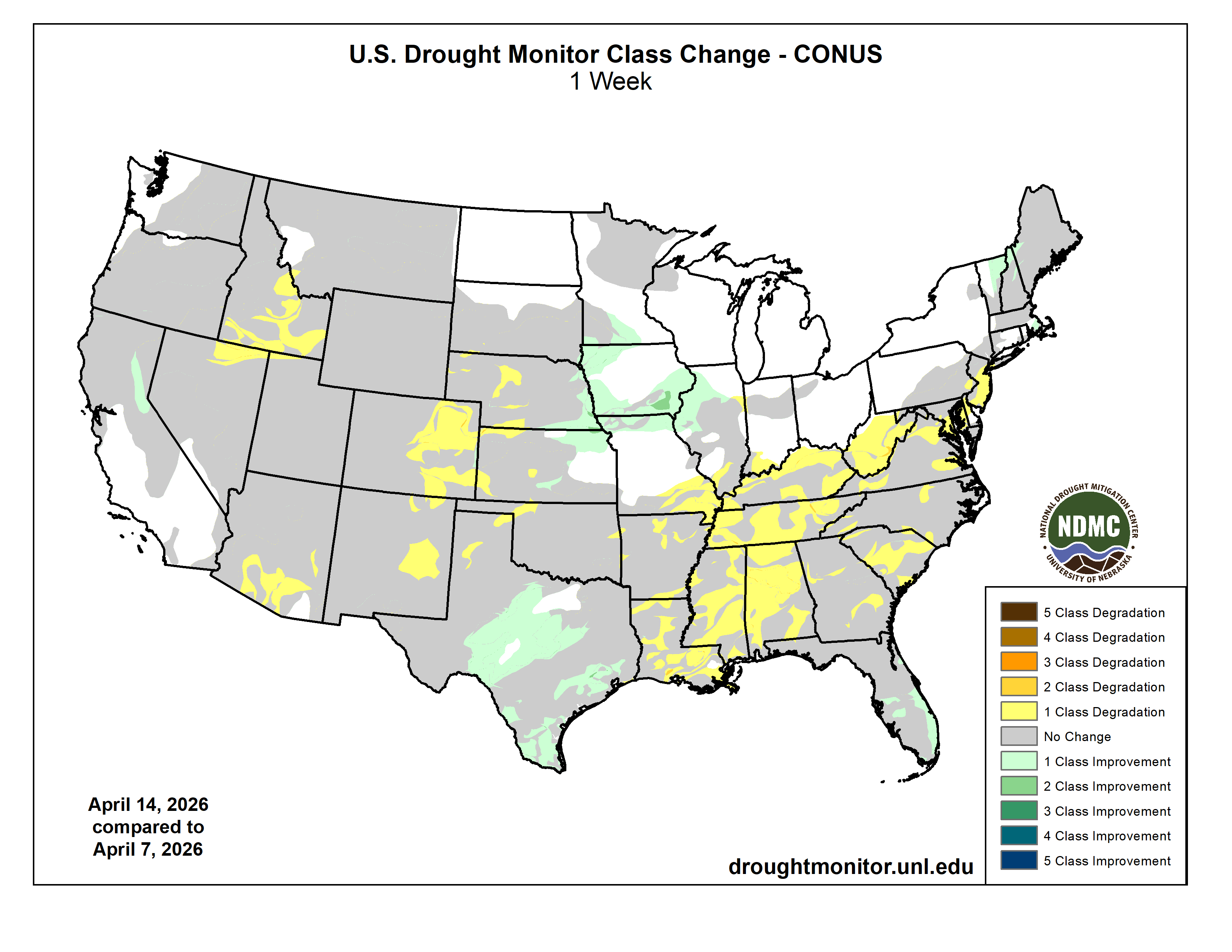
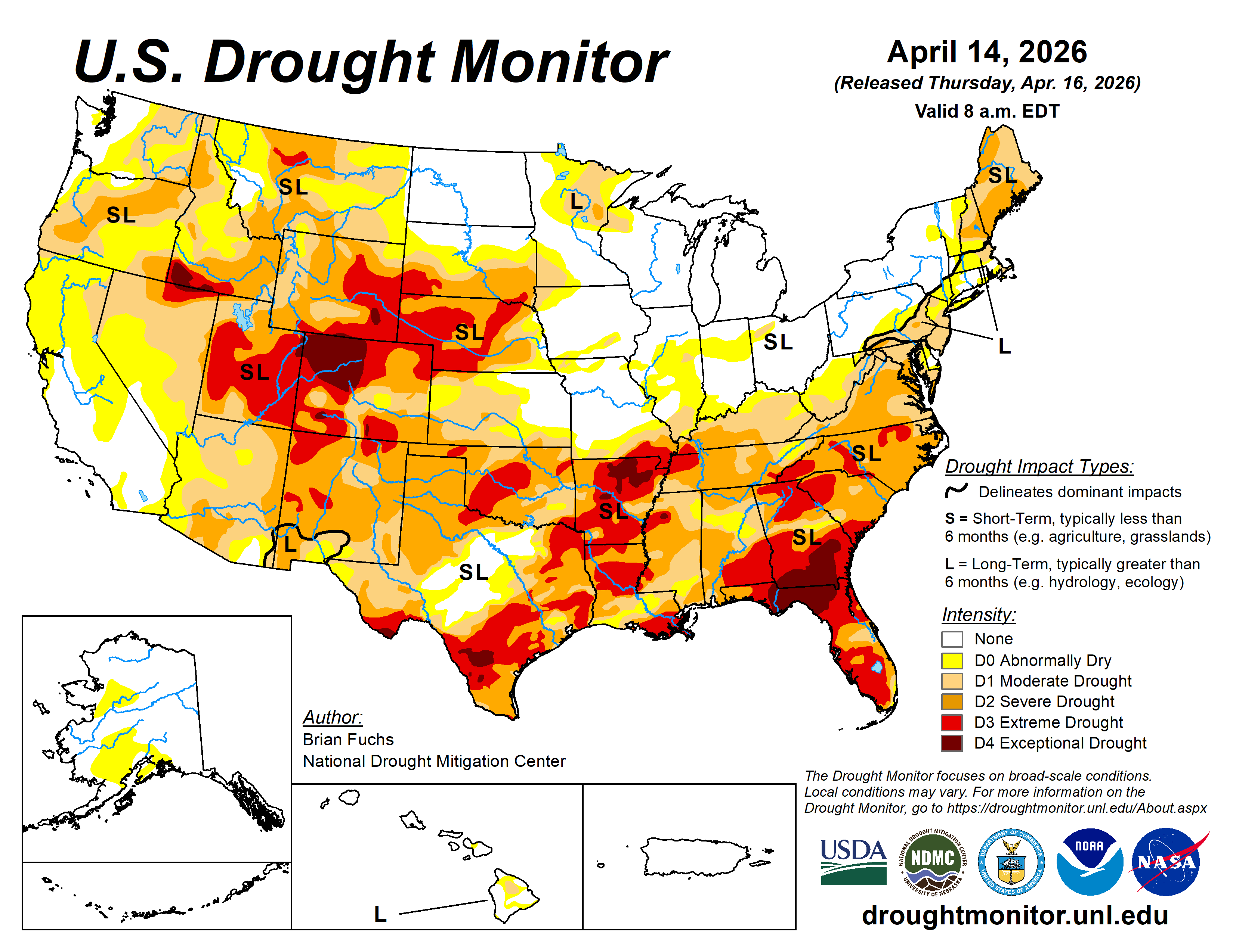
This Week’s Drought Summary
Much of the country continued to experience above-normal temperatures in April. During the last week, the warmest temperatures were over the southern Midwest and into the central Plains, where departures were 9°F or greater. California and portions of the Southeast into the Mid-Atlantic were near normal to slightly below normal. Dryness has continued in the Southeast, portions of the South, the Northeast, and much of the High Plains. The greatest precipitation occurred in the Great Basin, northern California, central and west Texas, northeast Kansas, and across much of Michigan and Wisconsin, where spring thunderstorms developed within an active weather pattern, mainly over the Midwest…
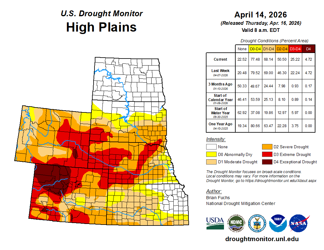
High Plains
Temperatures were mostly above normal, with only eastern North Dakota and northeast South Dakota near or below normal. The greatest departures occurred in central Kansas, where temperatures were 12–15 degrees above normal. Above-normal precipitation was observed in southwest and northern North Dakota.
Kansas experienced the most active weather, with southwest and eastern areas of the state and southeast Nebraska recording above-normal precipitation. Some areas of northeast Kansas received more than 400% of normal precipitation. These rains led to improvements in abnormally dry and moderate drought conditions across southeast Nebraska and northeast Kansas. Some areas of eastern Nebraska and south-central Kansas also saw improvements.
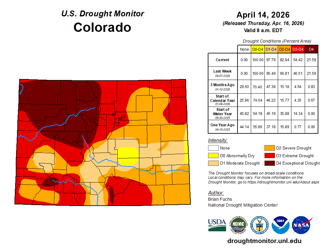
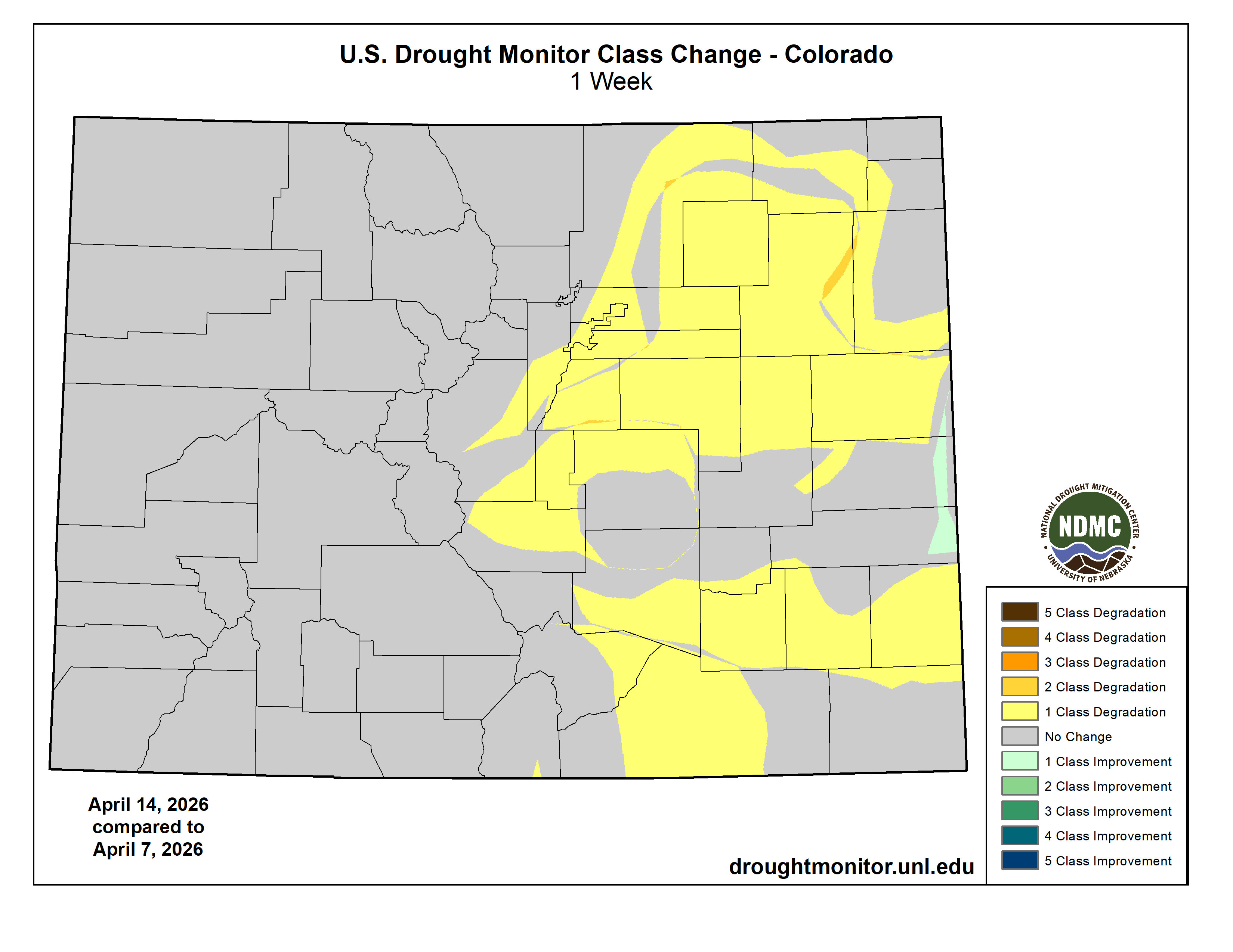
Extreme drought expanded across southwest Nebraska and northwest Kansas, while severe drought expanded across southwest Kansas. The plains of eastern Colorado experienced nearly a full-category degradation, with expansion of moderate, severe, and extreme drought…
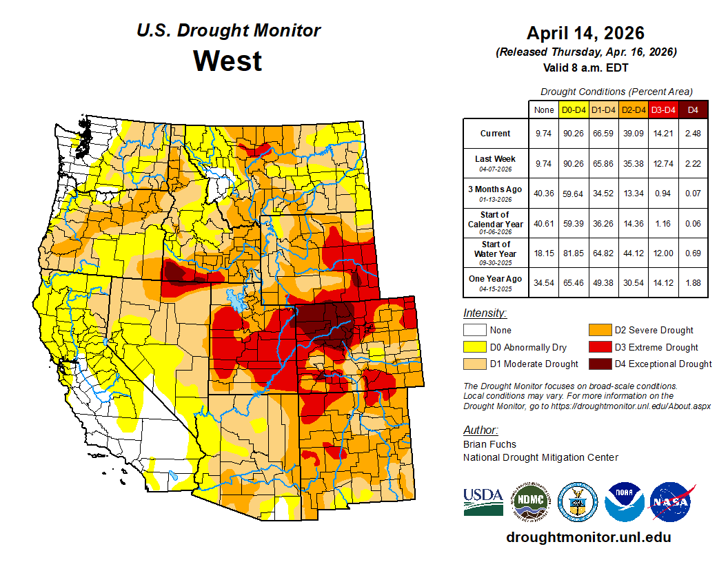
West
Warmer-than-normal temperatures dominated the region this past week. Departures were 6–8 degrees above normal across most of Utah, Colorado, and Wyoming. Only the Sierra Nevada area and northern California were near to slightly below normal.
Precipitation was mixed, with parts of northern California, northern Nevada, eastern Oregon, southern Utah, eastern and western New Mexico, southwest Idaho, and eastern Washington receiving above-normal precipitation.
The lack of snowpack will continue to impact the region in the coming months. Earlier-than-normal snowmelt, below-normal seasonal totals, and increased liquid precipitation are contributing to hydrological impacts.
Changes this week included improvements in moderate drought in northeastern California and expansion of moderate and severe drought in southern Arizona. Southern Idaho into northern Nevada saw expansion of severe, extreme, and exceptional drought, while severe drought expanded across eastern and northern New Mexico…
South
Precipitation was mixed across the region. Oklahoma and much of central and western Texas received more than 150% of normal precipitation. Farther east, eastern Arkansas and Louisiana saw light precipitation, while areas farther west and into Tennessee remained mostly dry.
Temperatures were above normal across much of the region, with only southern Texas, southern Louisiana, and eastern Mississippi near or below normal. The greatest departures occurred in western Oklahoma and the Texas Panhandle, where temperatures were 12–15 degrees above normal.
Drought expanded and intensified across much of Tennessee, with moderate and severe drought expanding statewide and a new area of extreme drought developing in the northwest. In Mississippi, moderate and severe drought expanded across eastern and southern areas, with extreme drought expanding in the northwest. Arkansas remained dry, with extreme and exceptional drought expanding in both northern and southern areas.
Louisiana saw expansion of extreme drought across much of the south, as well as central and northern areas. Moderate and severe drought also expanded across southern portions of the state. Oklahoma remained largely unchanged, with only minor expansion of severe drought in the panhandle.
The most significant improvements occurred in Texas, where much of central, southern, and southeastern portions of the state saw a full-category improvement in drought conditions. However, severe drought expanded in parts of the panhandle…
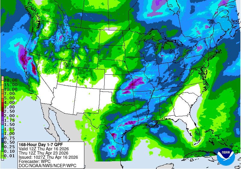
Looking Ahead
Over the next 5–7 days, precipitation is expected to be most prominent across the southern Plains, Midwest, and Northeast. The heaviest precipitation is likely from eastern Kansas into Missouri and northward into eastern Iowa, northern Illinois, and the Great Lakes.
Additional precipitation is expected from the Pacific Northwest into the northern Rockies and High Plains. Dryness is likely to persist across much of the Southwest and Southeast.
Temperatures are expected to be above normal from the northern Rockies into the High Plains, with the greatest departures in western Nebraska, eastern Colorado, and central Montana (10–13 degrees above normal). Cooler-than-normal temperatures are anticipated across much of central Texas (5–9 degrees below normal), while warmer-than-normal conditions are expected across the Mid-Atlantic (5–7 degrees above normal).
The 6-10 day outlooks show that the locations with the best chances of experiencing below- normal temperatures are in the Southwest, especially those locations in Arizona and southern Nevada and California as well as in New England with the best chances in both Arizona and Maine. There is a high likelihood of above-normal temperatures over much of the Midwest, Plains, and into the South and Southeast with the best chances over Kansas, Missouri, Arkansas, Oklahoma into southern Nebraska and Iowa. Precipitation chances are expected to be near-normal over southern Florida and southern areas of New Mexico and Arizona. Near-normal precipitation is also expected over the Pacific Northwest, upper Midwest and into the Northern Plains. In the Northeast, there will be a mix of near-normal to below-normal precipitation chances. Most of the rest of the country has above-normal chances of recording above-normal precipitation with the greatest chances over an area from northern Louisiana to Indiana.