
Click the link to read the article on the Colorado Climate Center website (Peter Goble):
September 3, 2026
You have likely heard news about El Niño recently. The National Weather Service reports that El Niño officially began in June. Observations from the International Research Institute show that it continues to strengthen. There is a greater than 90% chance of this becoming a “super” El Niño, and a greater than 50% chance of it becoming the strongest event since modern record-keeping began in 1950. Here is a look at what El Niño is and why it matters for Colorado.
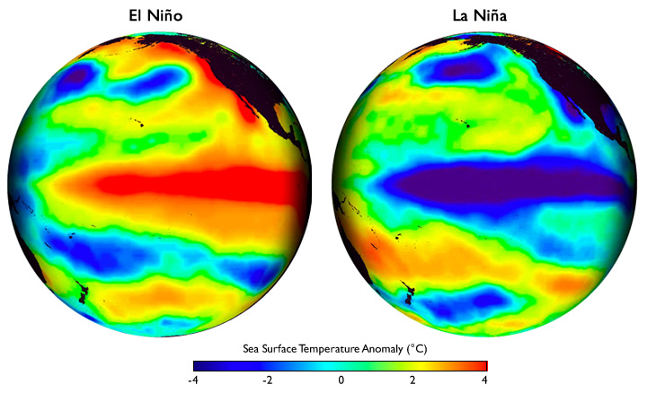
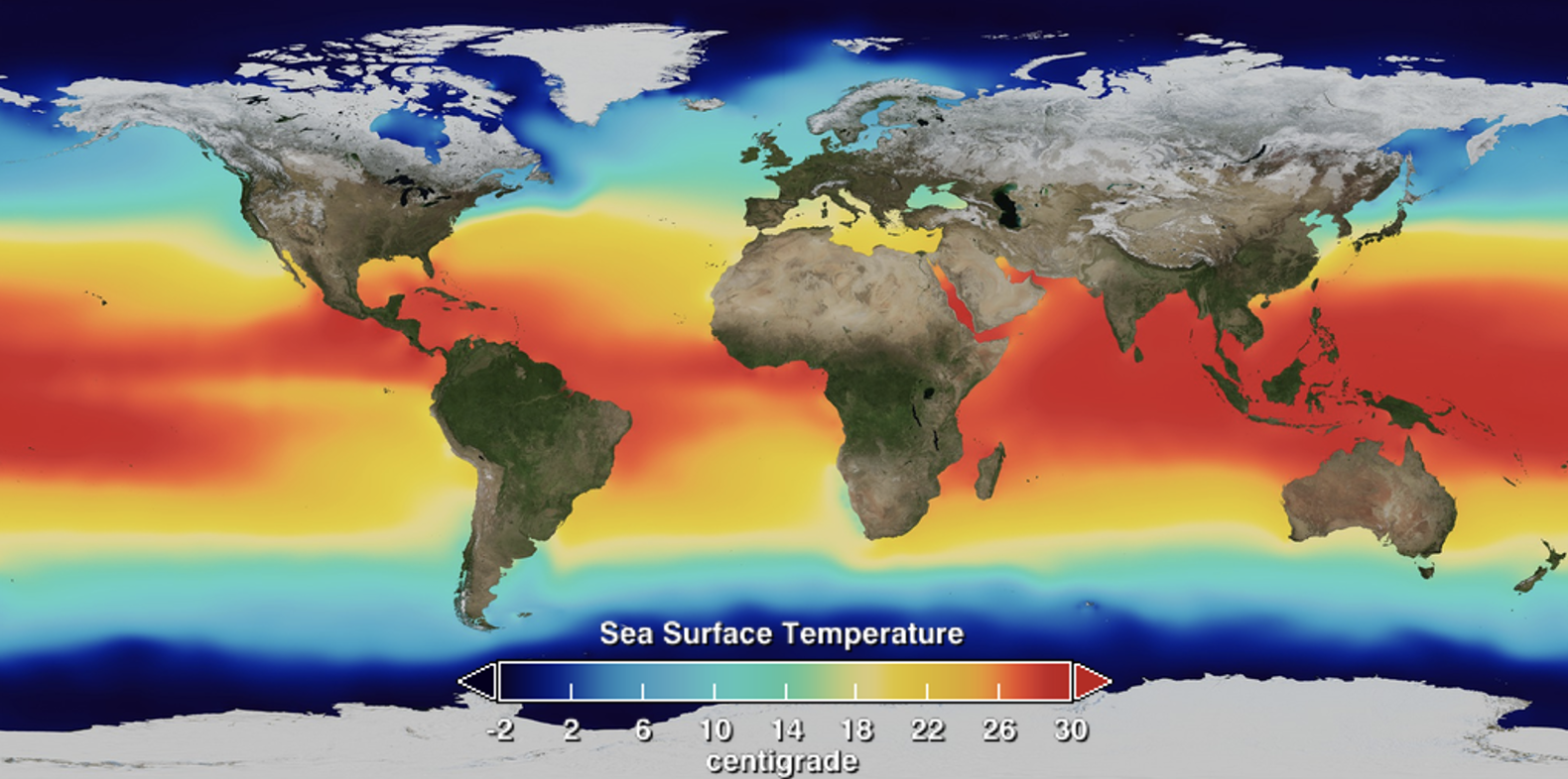
El Niño refers to a climate pattern characterized by unusually warm sea surface temperatures in the eastern tropical Pacific Ocean (image 1). Normally, waters in the eastern Pacific (off the coast of South America) are much cooler than those in the western Pacific (near Indonesia and Papua New Guinea) (image 2). Earth’s rotation drives tropical trade winds from east to west, pushing warm surface water westward and pulling cool, deep ocean water to the surface along the coast of South America. During El Niño, these trade winds weaken, allowing warm water to spread east and suppressing the normal upwelling of cold water.
El Niño conditions typically peak during northern hemisphere winter. Peruvian fishermenoriginally named the phenomenon (Spanish for “little boy,” or “Christ child”) after noticing coastal waters warmed around Christmas. While this meant less productive fishing in South America, El Niño also alters global oceanic and atmospheric circulation. Its most predictable weather impacts include warmer, wetter weather in the eastern Pacific, drier conditions across the Amazon, and warm, dry weather in Indonesia (image 3). These circulation shifts ripple into natural and human systems—for instance, El Niño correlates with higher mosquito-borne mortality in South America.
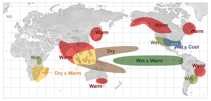
North America is impacted by El Niño as well. In response to weaker tropical trade winds, the northern hemisphere polar jet stream tends to weaken, and split with a more active southern flank. This raises the odds of cooler, wetter conditions across the U.S. Sunbelt, drier weather to the Ohio River Valley, and warmer conditions to the Pacific Northwest, north-central U.S., and a wide swath of Canada, and Alaska (image 4).

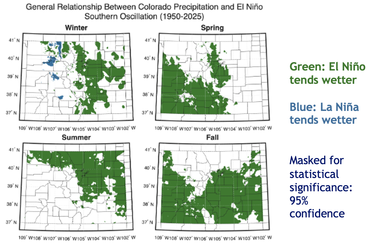
Historical correlation analysis shows El Niño is also linked to changes in Colorado weather, where conditions are generally wetter during El Niño years (image 5). This is especially true in fall and spring, when much of the state averages higher precipitation. Furthermore, the Front Range and Eastern Plains are more prone to large spring snowstorms and experience fewer dry and windy spring days (though such days remain frequent regardless). Unfortunately, the link between the El Niño–Southern Oscillation (ENSO) and peak seasonal snowpack levels in Colorado is weak. Southern river basins, such as the San Juan and Rio Grande, show a loose positive correlation between El Niño and snowpack (image 6).

Does a stronger El Niño guarantee more intense impacts? Not necessarily. Linear correlation models assume stronger events yield stronger outcomes, but real-world evidence is limited. Modern records include only three “super” El Niños (sea surface temperature anomalies of +2.0 °C or higher): 1982/83, 1997/98, and 2015/16. While 1982/83 delivered huge snowfall to Colorado, the latter two yielded roughly average conditions. Drawing firm conclusions from three events is unreliable, and our physical understanding of Earth’s climate system offers no clear threshold where impacts suddenly scale. On the positive side, dynamical seasonal climate models and the Climate Prediction Center both indicate elevated odds of above-normal precipitation across most of Colorado through spring.
Climate change complicates our understanding of what we can expect from a strong El Niño. Earth’s climate system has changed since the super El Niño and major snow year of 1982/83. Colorado is warming, and average precipitation is likely decreasing in western Colorado. The correlation analyses shown above do not account for these shifting baselines. A wet year is not guaranteed. Even if the storms do come, less of the precipitation may fall as snow than in a typical year, especially at lower elevations. Colorado continues to suffer from severe droughtlargely driven by snowpack deficits last winter and record warm temperatures. There is a strong appetite among people for moisture. The brewing super El Niño may offer some hope, but a wide array of outcomes are possible this winter. It is a bit like playing a game of poker with a few extra aces and kings in the deck. The deck may be stacked in our favor, but we could still draw a crummy hand.