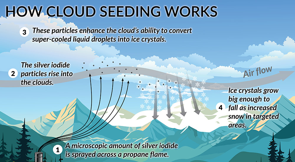
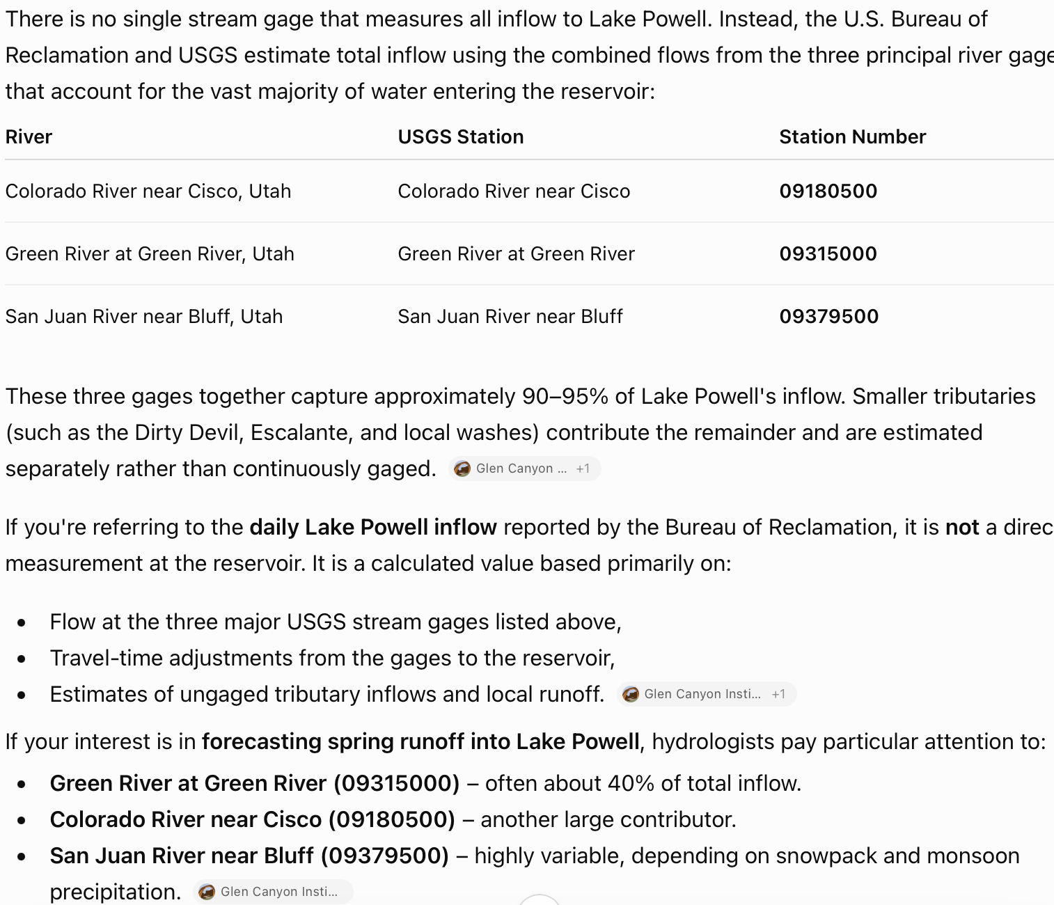
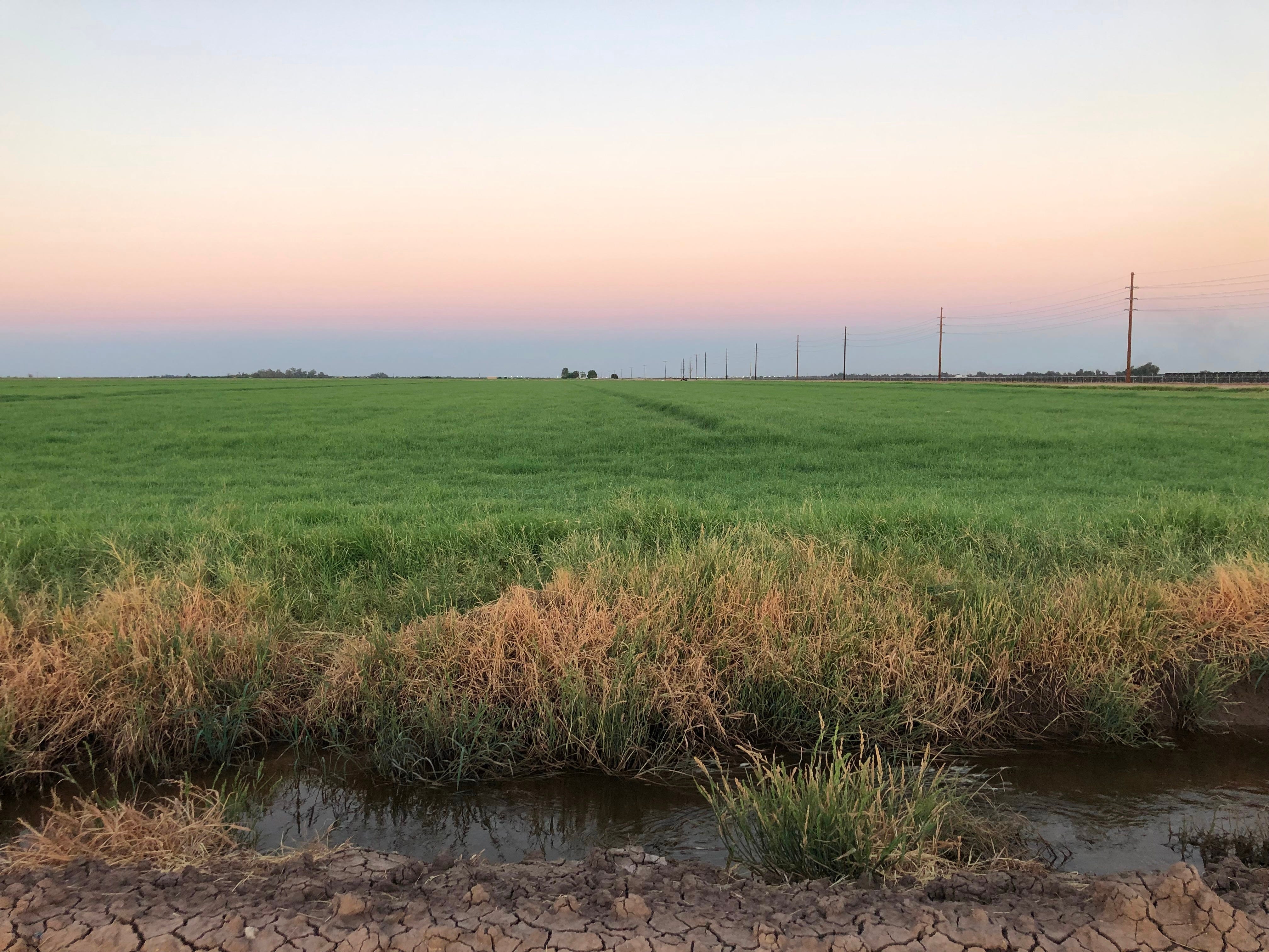
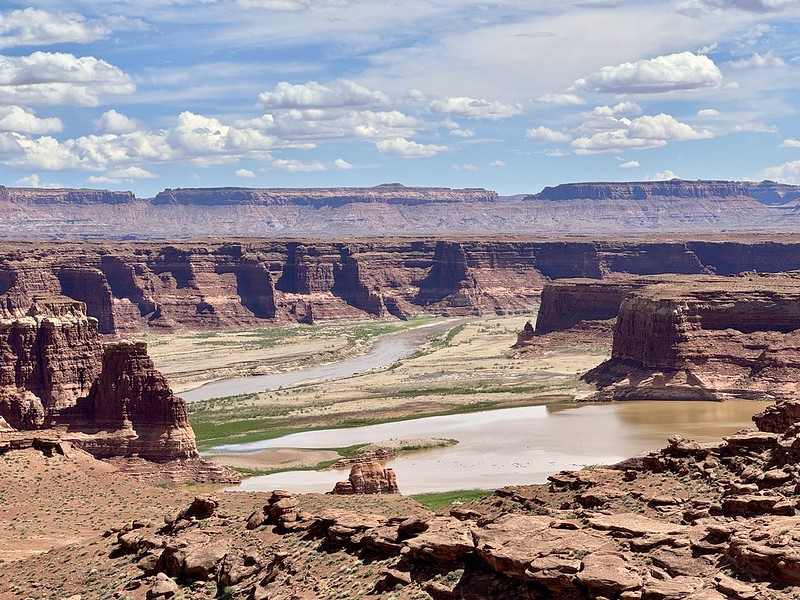
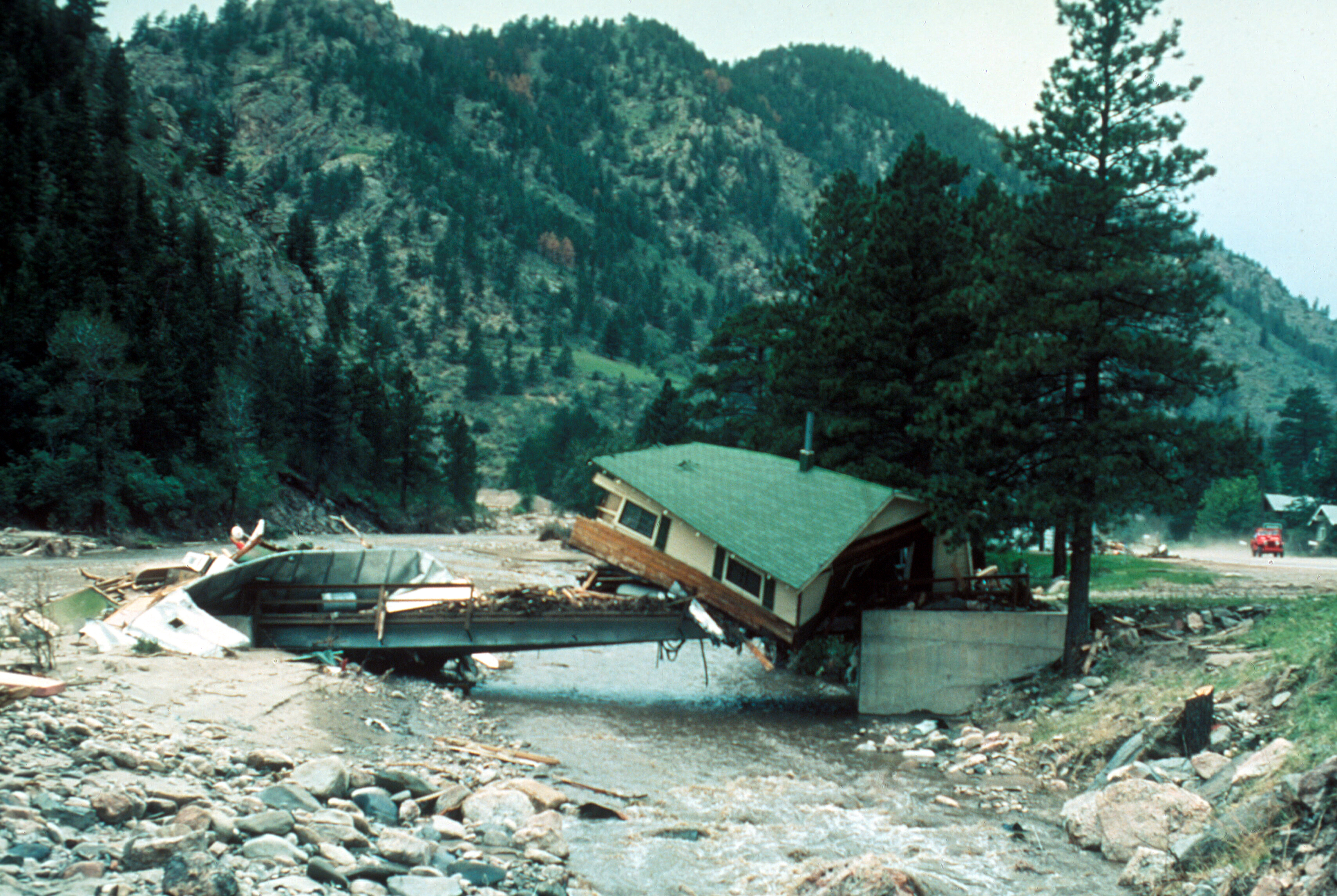
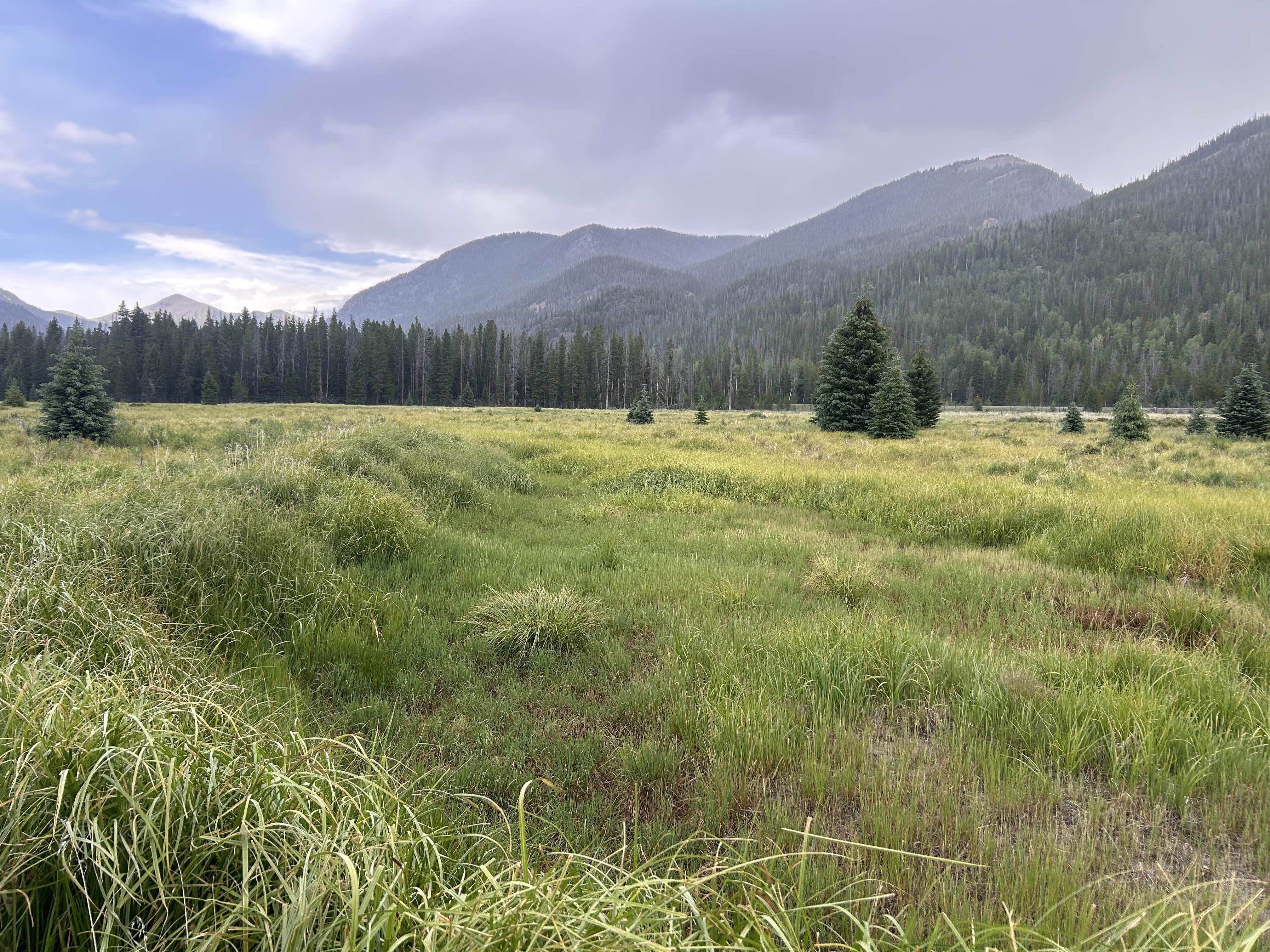
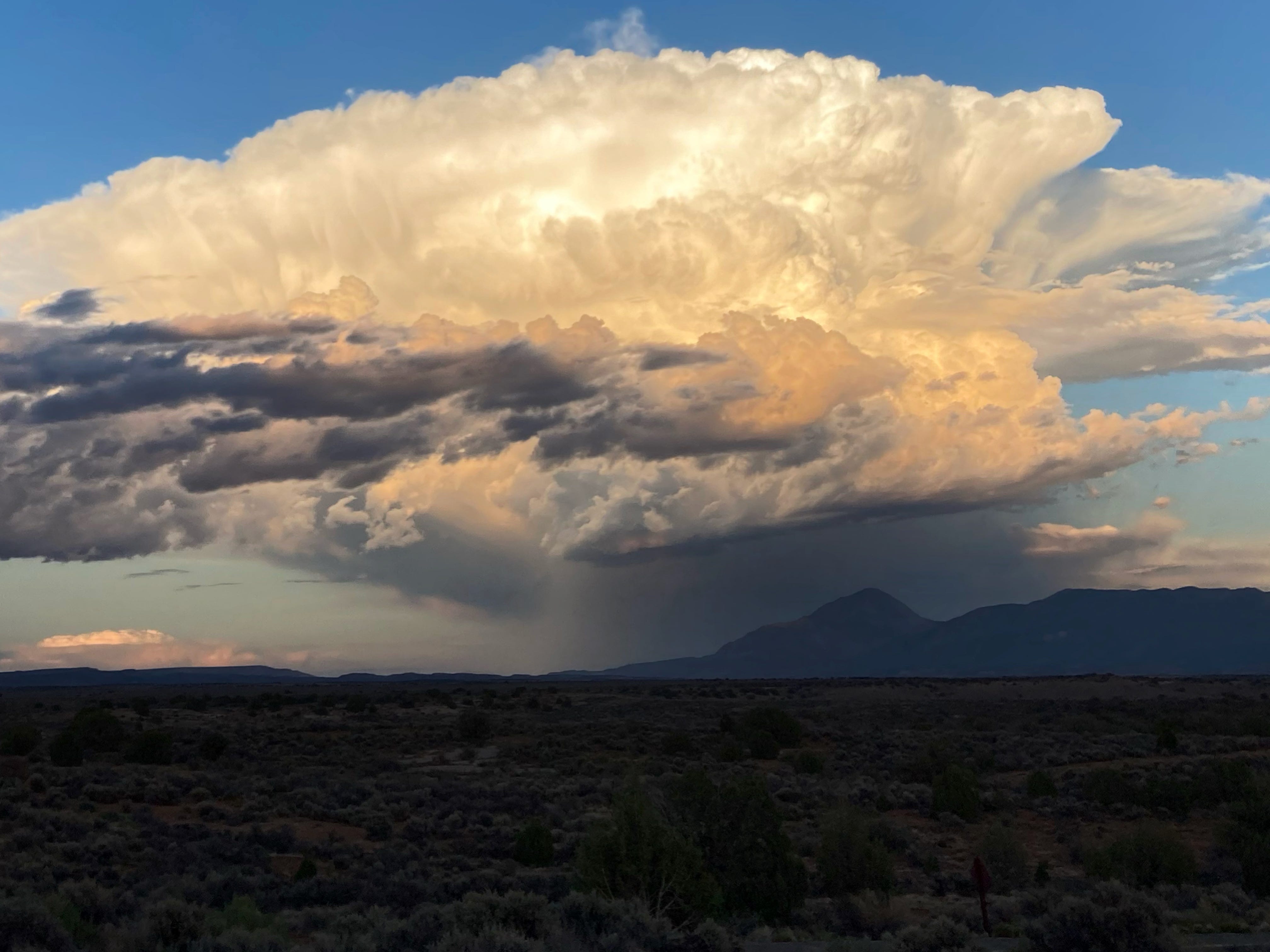
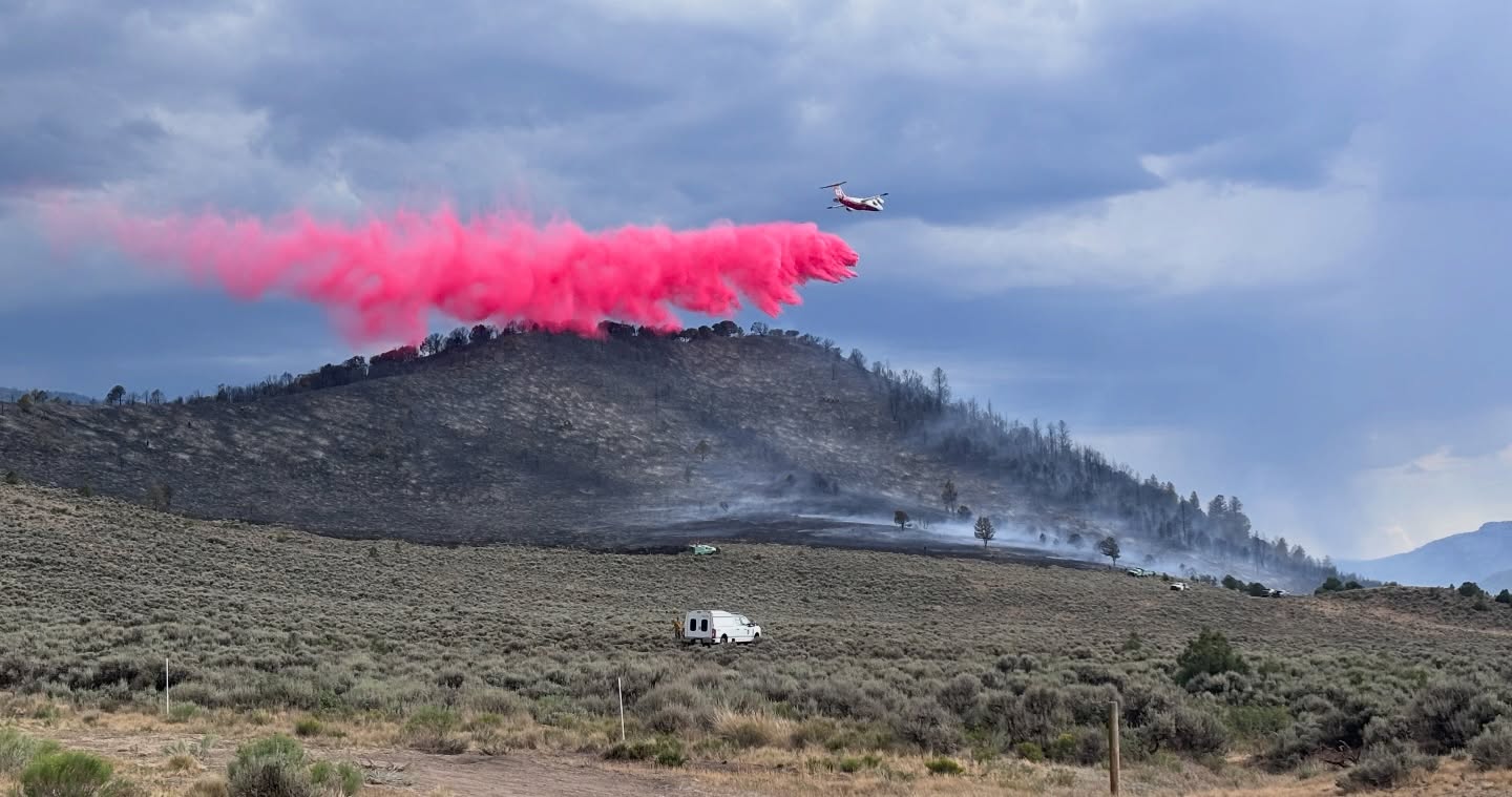
The DRI Cloud Seeding Research Program uses ground-based generators, which are designed and built by DRI and can be operated remotely. Most cloud seeding operations, including those run by DRI, use a compound called silver iodide (AgI) to aid in the formation of ice crystals. Silver iodide exists naturally in the environment at low concentrations, and is not known to be harmful to humans or wildlife. When storm systems move through one of our cloud seeding project areas, a solution containing a small amount of silver iodide is burned from ground-based generators or released from aircraft. Upon reaching the cloud, the silver iodide acts as an ice forming nuclei to aid in the production of snowflakes. Credit: Desert Research Institute
Click the link to read the article on the KJZZ website (Alex Hager). Here’s an excerpt:
August 7, 2026
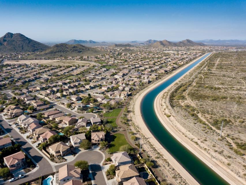
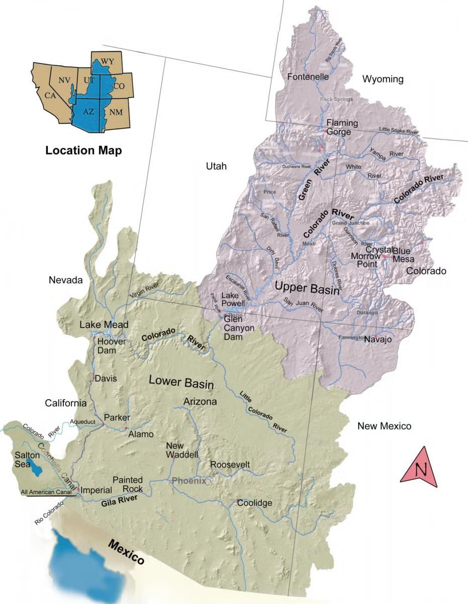
The Central Arizona Project runs a 336-mile-long canal system that carries water from the Colorado River across the desert and into the Phoenix and Tucson areas. Since 2007, it has been part of a collaborative effort to run cloud seeding equipment in the Rocky Mountains. The program brings together water users that benefit from faraway snowmelt — like CAP, water agencies in Las Vegas and Los Angeles and major farming districts in Southern California — and agencies that manage water near the snowy mountains themselves. Now, the future of CAP’s participation in that collaboration is in question. At a meeting of the CAP board of directors on Thursday, the cloud seeding program got caught in the middle of bigger water politics.
“I know we’ve been funding this for almost 20 years, and now everybody’s trying to cut us off,” said Barbara Seago, a CAP board member representing Maricopa County. “So my take is, why would we keep funding anything that benefits Colorado if they’re willing to cut us off?”
[…]
In recent years, water agencies in Arizona, California and Nevada have sent about $1.5 million per year to upstream cloud seeding work. Those agencies say it is a small part of the solution to the complicated, politically fraught issue of supply-demand imbalance along the Colorado River, but it is still worthwhile. Technical experts on CAP’s staff explained the program to the board as a way to benefit the Colorado River system overall, even if it is difficult to draw a straight line between dollars spent on cloud seeding and water that physically flows into Arizona’s reservoirs and canals.
“If we have more water on the ground in the watershed,” said Nolie Templeton, CAP’s Colorado River policy and analysis manager, “Then I think everybody in the watershed is going to benefit because more of that water will make it into our rivers and streams.”
Central Arizona Project map via Mountain Town News
Denver Water’s 1.5 million customers are using less water than usual, but it’s still not enough to meet the utility’s goal of reducing water consumption by 20% amid this year’s drought.
“We’d need to be at 10,300 acre-feet of savings. Instead, we are at 1,300 acre-feet of savings, so behind where we want to be,” said utility spokesperson Todd Hartman.
That means the utility, which serves residents in Denver and many surrounding communities, has achieved barely a tenth of its target.
In Aurora, water officials said locals have made progress toward that utility’s 20% goal, but did not provide exact statistics.
While the utilities aren’t hitting their goals, they’re not ringing alarms yet. Both utilities have implemented Stage I water restrictions, and neither plans to move to the more severe restrictions of Stage II.
But that could change depending on how water levels look for the rest of the year — and Aurora Mayor Mike Coffman said it could be soon. In a Facebook post, Coffman wrote that the city is “now teetering on having to move to Stage II drought restrictions that, if enacted, will reduce all outdoor irrigation from two waterings a week down to one, killing off most lawns completely. According to [Kirby] Shedlowski, however, Stage II restrictions are not yet on the table. She said Aurora Water staff would have to recommend that shift to the Aurora City Council, which hasn’t happened yet.
From Tishana ‘Tish’ Cano at the Greeley Water & Sewer Department:
“Here is a land where life is written in water.” Thomas Hornsby Ferril, named Colorado’s poet laureate in 1979, could not have composed a better description of the agricultural community founded at the confluence of the Cache la Poudre and South Platte Rivers. In April 1870, a group of far-seeking settlers after a long four-day train ride from New York City and other points back East. Their goal was to create a new way of life on the dry and desolate plains of northern Colorado. Water was the key – and in 1874, a conflict with upstream irrigators of the agricultural community of Fort Collins created a flashpoint in Colorado water law and the American West. Both sides met “half-way” near present-day Windsor and launched an iconic, heated debate over western water rights. With guns used in the Civil War at the ready, the parley led to the birth of western water law – the Doctrine of Prior Appropriation.
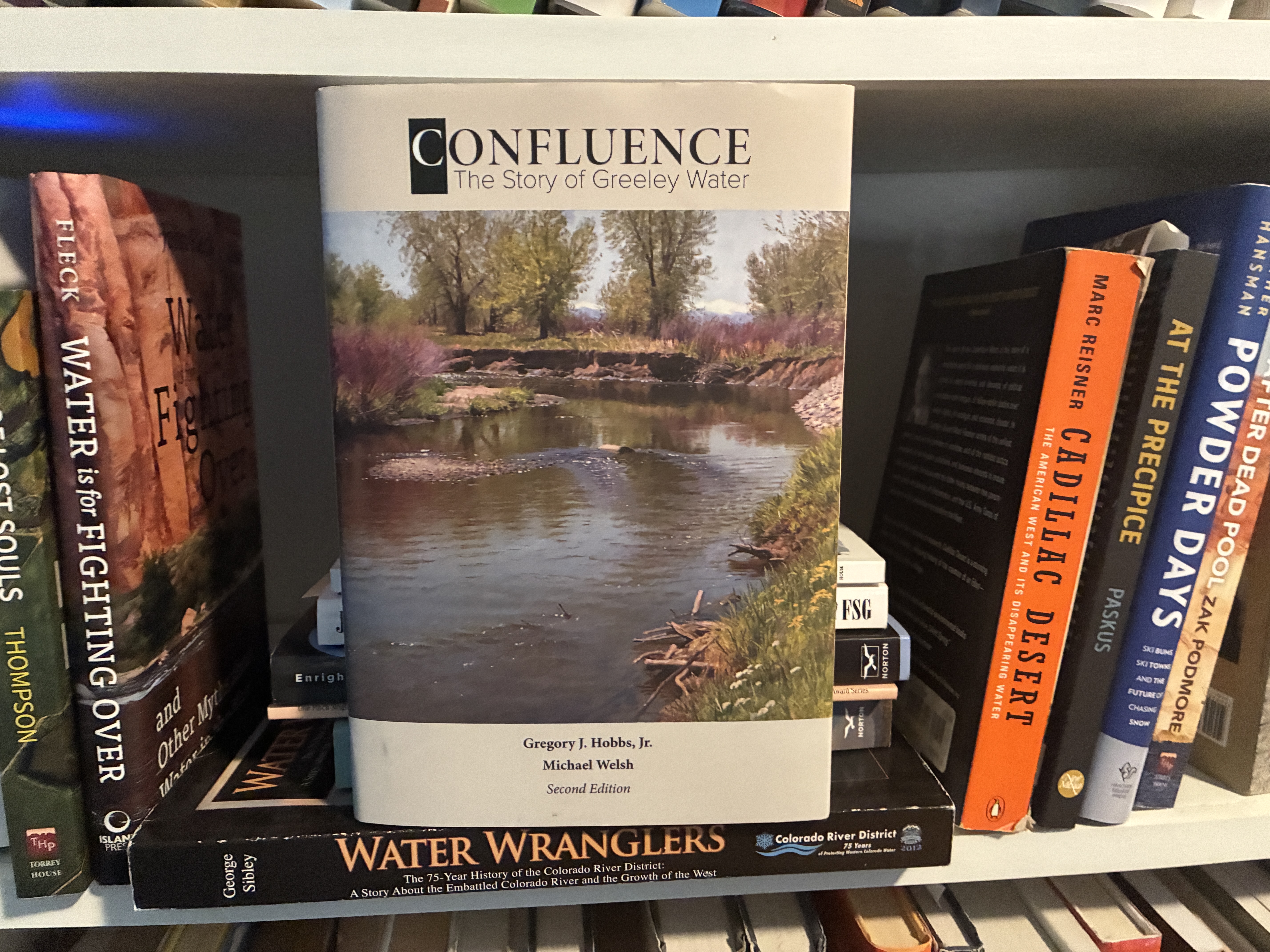
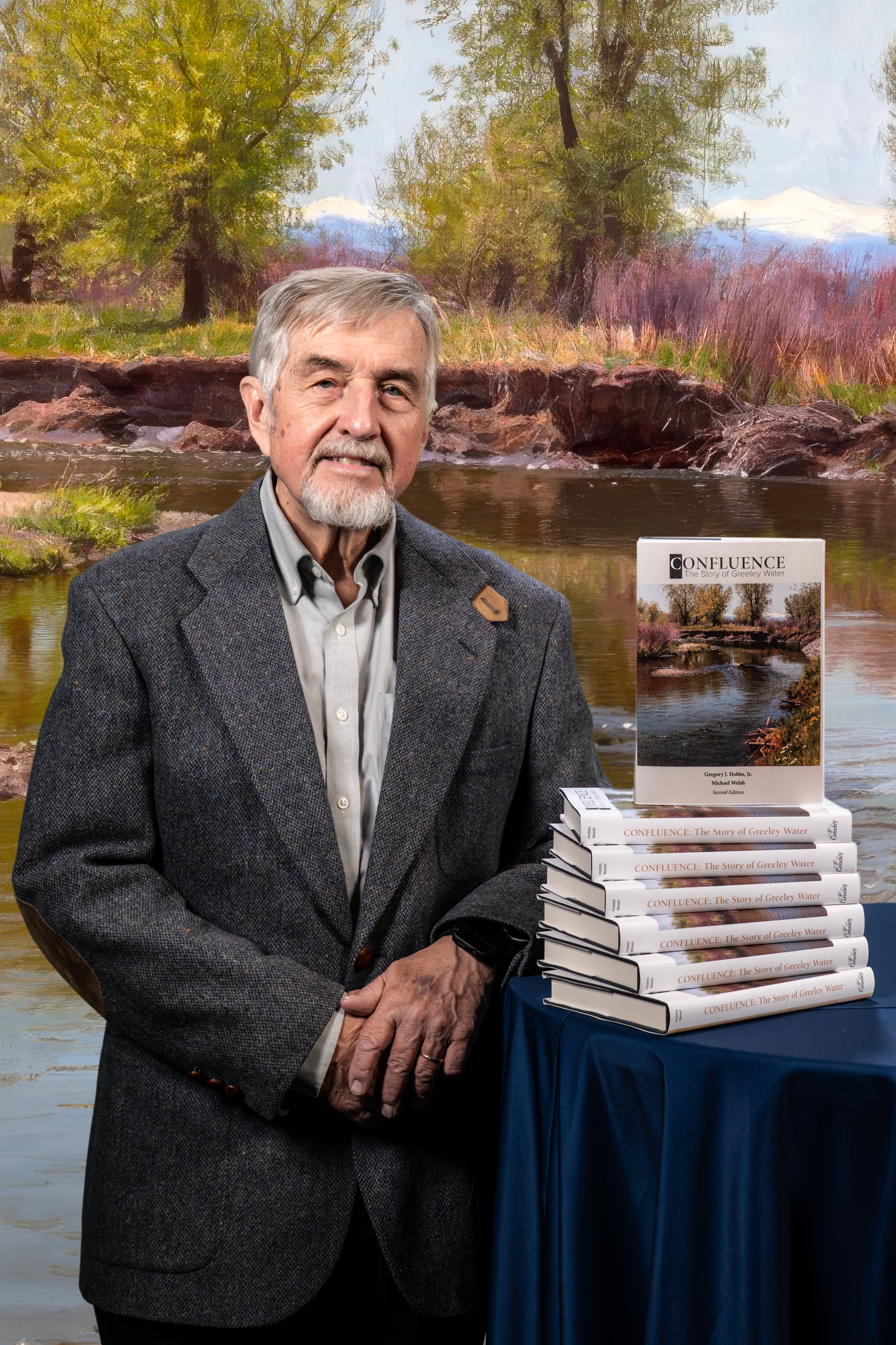
Authors Gregory J. Hobbs, Jr. and Michael Welsh describe the triumphs and challenges of Greeley’s water history, from its 1884 artesian well in City Park to its 1907 mountain water system. The book chronicles the Colorado-Big Thompson Project of the 1930s and the Milton Seaman Dam and Reservoir construction in the 1940s. Hobbs and Welsh describe the foresight and tenacity of creative men – David Boyd, Henry C. Watson, Delph Carpenter, W.D. Farr, Harold Evans, and others – who shouldered the work and pointed the way to identify, acquire, and deliver affordable water to Greeley for more than a century. “Plan for others as they have planned for you” guides and unites the actions of our story of Greeley Water.
From the Rocky Mountain American Water Works Association:
Public works agencies rarely have time to reflect on their accomplishments and lessons learned, as they pursue on a daily basis their operations, maintenance, and plans for future growth. Yet that retrospective is what the City of Greeley Water Utilities Department, with its century and one-half of service to the community, decided to engage with the research and publication of Confluence: The Story of Greeley Water (2020).
Harold Evans, chairman of the Greeley Water and Sewer Board for the past two decades, believed that those whom the utility served would benefit from a comprehensive analysis of the origins and development of an organization that began before Colorado statehood, and one that has grown over time by addressing the cycles of abundance and scarcity of water that define the Headwaters State.
Joining the team of researchers and writers in 2015 were Gregory J. Hobbs, Junior, a retired associate justice of the Colorado State Supreme Court, often considered the most knowledgeable member of the high court in matters of water law and policy, and Michael Welsh, a professor of history at the University of Northern Colorado, whose decades of teaching and scholarship included studies of the U.S. Army Corps of Engineers in the Southwest and on the West Coast.
This team explored the range of issues and tasks of a municipal water system that began in the summer of 1870 with a single irrigation ditch on the Cache la Poudre River that conveyed water to the fledgling Union Colony (later to become the town of Greeley). As the population increased and the economy evolved, the Greeley water utility added a community artesian well (1884); a mountain water treatment facility above Fort Collins at Bellvue (1907); and a storage facility on the North Fork of the
Poudre River known as Milton Seaman Reservoir (1945); the latter two remaining operational over a century later. Residents of the Colony, and their policies and regulations, also played an important role in the development of statewide and interstate water law. One example would be the enshrining in Colorado’s 1876 constitution of the “prior-appropriation doctrine.” In addition, a Greeley native, Delph Carpenter, who had been employed as a youth inspecting the community’s ditch system to guard against violation of its rules, became an authority on the collaborative features of western water law. Carpenter would be tasked by the U.S. Commerce Secretary, Herbert Clark Hoover, with a key role in the drafting of the Colorado River Compact.
That agreement would permit a group of Greeley and Colorado water professionals a decade later to approach the U.S. Bureau of Reclamation to confront the severity of the Great Depression and the Dust Bowl by means of the Colorado-Big Thompson Project; a multipurpose facility that secured the future for farmers and ranchers of the South Platte River basin, and later the urban growth of the Front Range.
The Greeley Water & Sewer Board, originating in 1958 from the idea that local decisions in water belong with the people, and guided by those who understood and appreciated what water meant to Greeley, established the nonpartisan principles that inform the acquisition and development of water facilities. From the leadership of water pioneer W.D. Farr to today, with Harold Evans, who has a background in Civil Engineering, the Board has possessed expertise and foresight that contributes to Greeley’s good fortune with its most precious resource.
What began with that first ditch has now become a network of multiple reservoirs in four river basins, and prize-winning water pollution-control facilities. The City of Greeley also has taken the lead in water efficiency & quality, working with state and federal partners to replace aging lead pipes, and to institute an advanced metering system and residential and commercial “water budgets” that keep utility customers informed of their use patterns and the value of conservation in times of drought. Once the first volume on the story of Greeley water appeared, the water utility continued to provide domestic water and wastewater treatment to its network of communities. The City also pursued regional cooperation with the municipalities of Fort Collins, Loveland, Windsor, and Evans. Greeley maintained its partnership with the Northern Water district, in particular its Chimney Hollow Reservoir, which will store additional supplies for a dozen water organizations that own water rights in the CBT system that are not reliably accessible in times of need.
From that recognition in 2020 that the story of Greeley water had not ended came a new edition in the summer of 2026, written to incorporate the purchase of water rights to the vast underground aquifer in far northern Colorado known as the Terry Ranch Project. Other dimensions of the utility’s operations addressed in the second edition of Confluence are the expansion of the “non-potable” water system for use in public and private spaces; the application of sophisticated information technology; and the advanced-planning functions of the “Integrated Water Resources Program,” which identifies scenarios and options for a wide variety of challenges and opportunities in water-resource management decades into the future.
It is our hope that this new look at an old story helps residents and businesses of Greeley and surrounding communities realize how important their water supplies are to their security and prosperity. In 1941, in the midst of a world at war, and as the decade of the Dust Bowl neared an end, Greeley’s leaders embraced a simple but compelling idea: “To plan for others as others have planned for you.” Wise words for their time, and wise words for ours now.
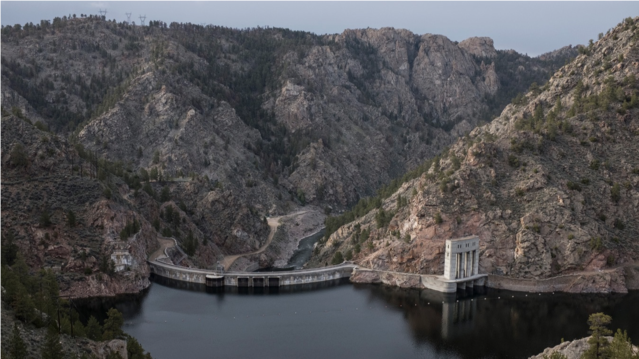
The Seminoe Reservoir backs up at the Seminoe Dam, with the North Platte River flowing freely below to the downstream Kortes Dam above the Miracle Mile. (Ryan Dorgan/WyoFile)
Click the link to read the article on the WyoFile website (Dustin Bleizeffer):
August 6, 2026
Driven by historically low snowpack and above average temperatures this summer, Seminoe Reservoir has slipped into “near-worst case” water quality modeling scenarios that federal officials are relying on to greenlight a controversial pumped-water storage hydroelectric project there.
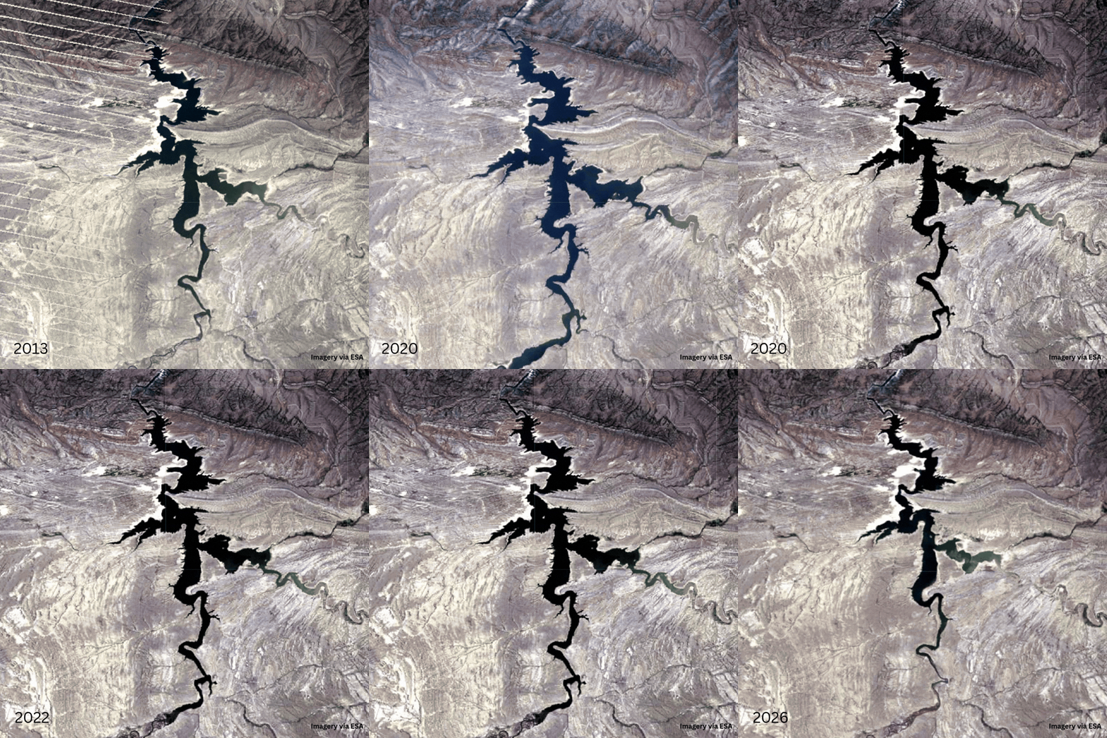
The Carbon County reservoir, which stores water in the North Platte River system, measured just 29.4% capacity Wednesday [August 6, 2026], with a surface water elevation of 6,303 feet above sea level, according to the U.S. Bureau of Reclamation. That’s 12 feet below a “near-worst case” scenario of 6,315-feet elevation for the reservoir based on modeling of past years that opponents of the storage project have criticized as incomplete and shortsighted in consideration of changing climate in the region.
If the facility were in operation today, Seminoe’s current water level would trip a regulatory trigger enforced by the Wyoming Department of Environmental Quality, requiring developer rPlus Hydro to temporarily curtail operations, according to state and federal documents.
“Not a single shovel has hit dirt yet, and we’re already living in the near worst-case scenario,” Trout Unlimited’s Wyoming Government Relations Director Patrick Harrington told WyoFile. “What happens if next year looks like this year and we don’t refill Seminoe? What happens when the system experiences conditions that are drier than those that underpin the environmental analysis?”
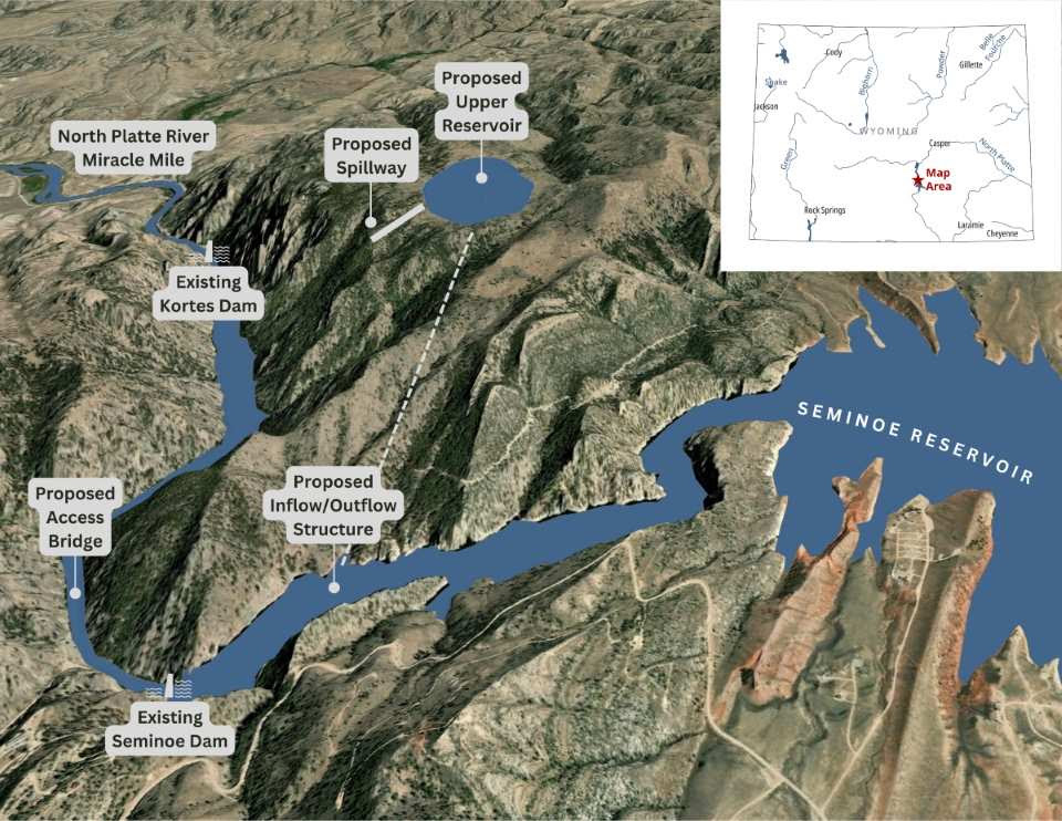
This map depicts a proposed pumped water storage energy project at Seminoe Reservoir. (rPlus Hydro)
Utah-based rPlus Hydro, along with its subsidiary Black Canyon Hydro, expects to receive final approval from the Federal Energy Regulatory Commission this year to construct its Seminoe pumped-water storage project. The company wants to carve a new reservoir on a hill above the Seminoe dam, pump water from Seminoe uphill during the day and release the water through hydroelectric-generating turbines in the evening — an electrical “battery” to provide power when it’s most needed, it says.
The commission in June issued its final environmental impact statement for the project, sparking criticism that it ignored input from local leaders and failed to incorporate more protective measures for fisheries and wildlife, including for the Seminoe-Ferris bighorn sheep herd.
Miracle Mile worries
Among local concerns regarding the $4 billion, five-year construction project is the Miracle Mile stretch of the North Platte River below the Seminoe and Kortes dams. It’s a world-class trout fishery that attracts millions in tourism dollars annually. It’s also designated as an “Outstanding Resource Water.” That decades-old designation, according to the Wyoming Department of Environmental Quality, requires that it suffer “no further degradation from human activity” — a legally enforceable sideboard that the state, as well as natural resource advocates, hope will protect the popular fishing destination.
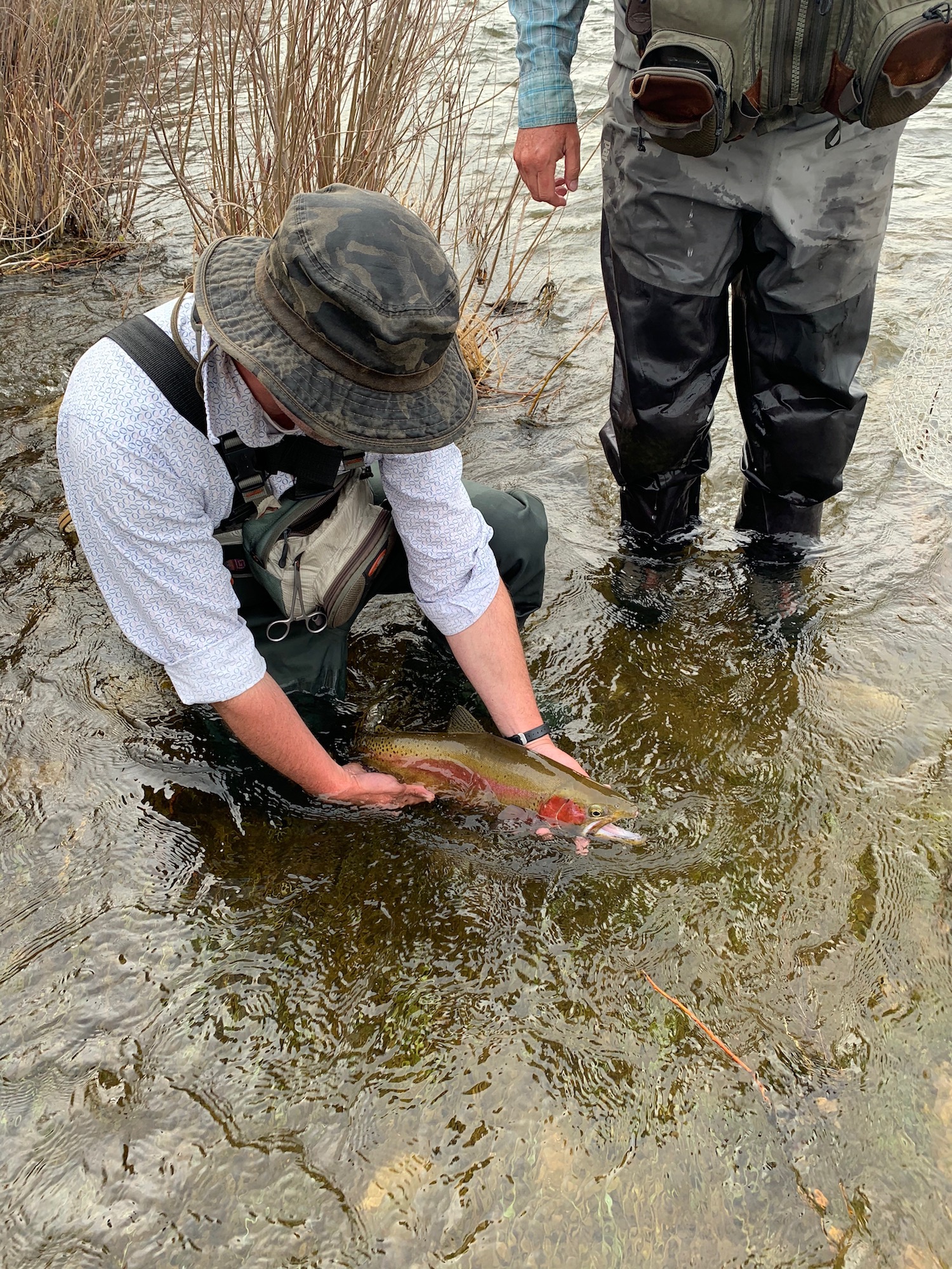
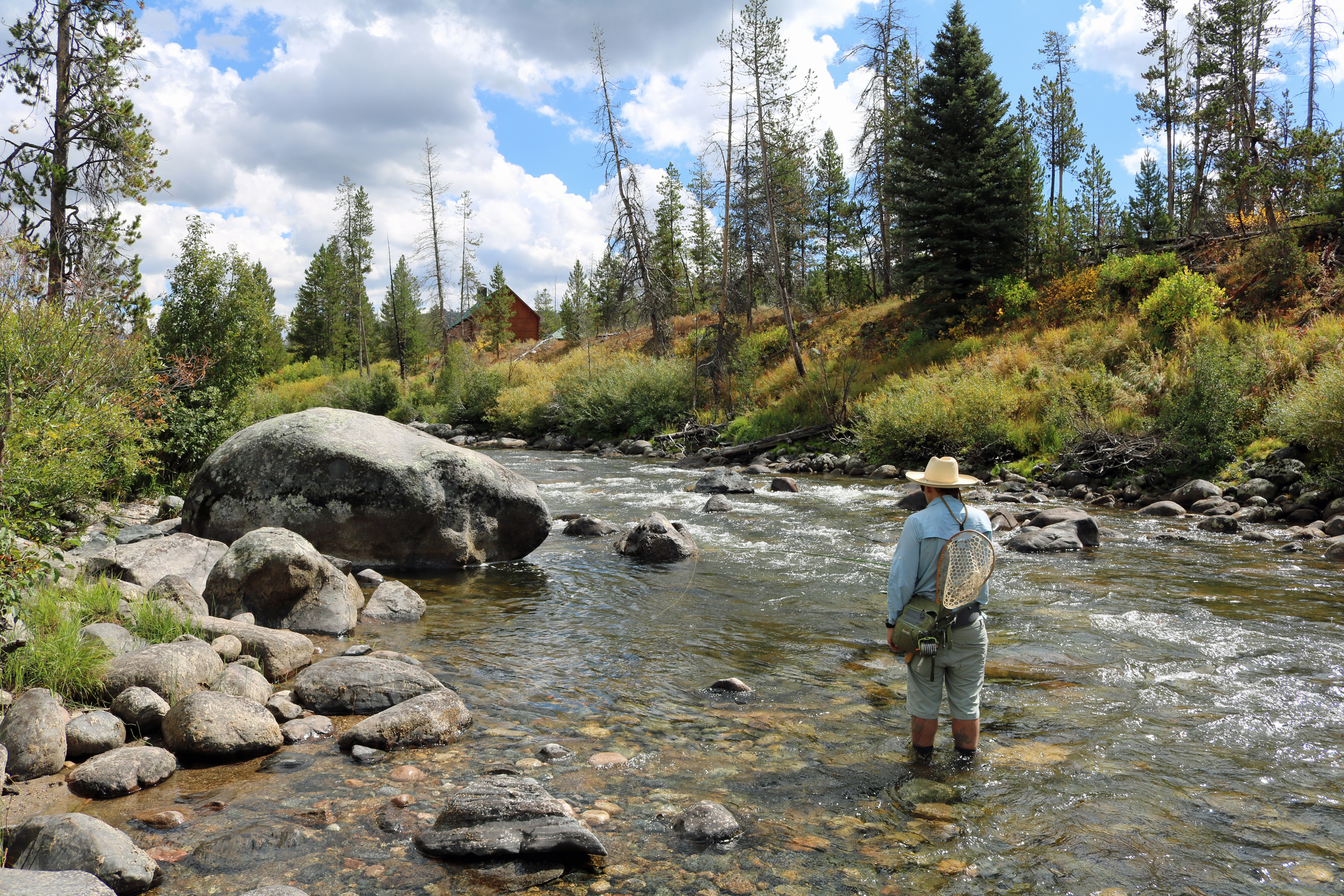
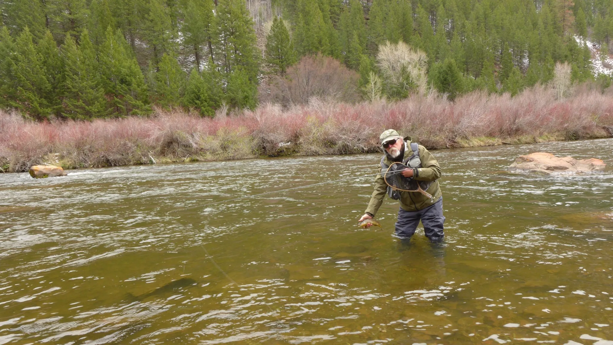
An angler releases a trout caught on the Miracle Mile portion of the North Platte River below Seminoe Reservoir. (Dustin Bleizeffer/WyoFile)
A cold-water species, trout get stressed when water temperatures range between 70 and 75 degrees Fahrenheit. Prolonged temps beyond that can result in a fish kill, according to the Wyoming Game and Fish Department.
Typically, “tailwater” portions of rivers immediately downstream of dams like the Miracle Mile get the benefit of the coldest water in the reservoir, because dam outlets are far below the surface where temperatures tend to be warmer. But rPlus Hydro’s facility would churn the reservoir’s water temperature strata, especially when water levels are low, according to state and federal analysis.
The North Platte River system has suffered low-water conditions this year, beginning in February with various “priority administration” calls that limit irrigation for some users. Though no towns or industrial water users along the main stem have gone without, many of them have dipped into a state-owned backup water supply held in reserve at Pathfinder Reservoir, according to Wyoming State Engineer Brandon Gebhart.
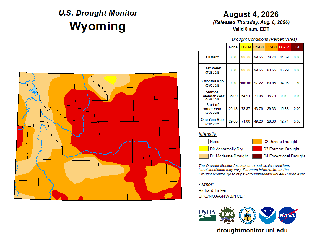
“The entire state is under some classification of drought,” Gebhart told the Wyoming Legislature’s Select Water Committee Thursday. “Over 83% of the state is in severe or extreme drought.”
Gebhart added that many reservoirs in the North Platte drainage system — excluding those on the main stem of the river — are at “dead pool,” meaning water levels are lower than the dam’s outlet, preventing downstream release.
Regulatory analysis, stipulations, so far
Under “moderate” drought conditions, the facility’s daily churn “has the potential to exceed the 1.1 °C [about 2 degrees Fahrenheit] criterion” for the Miracle Mile if Seminoe shrinks below 6,326-feet elevation in July and 6,315-feet elevation in August, according to DEQ. That’s likely to happen about once a decade, the agency concluded in its “adaptive management plan,” which prescribes how rPlus Hydro must comply with the Outstanding Resource Water designation for the Miracle Mile, among other water quality regulations.
But Trout Unlimited and other natural resource advocate organizations note that the analysis is based on a slice of past hydrological data for the Seminoe-Kortes-Miracle Mile waters — from 2013 through 2016. The former was the lowest water-year dataset used to help determine reservoir water level and water temperature parameters, though data was available from other years when water was lower, according to Trout Unlimited and the Lander-based advocacy group Wyoming Outdoor Council.
“Why would the model not include the historic range of natural variability to set realistic triggers for the [water quality adaptive management plan] when at least 25 years of historical data was available, including two highlighted years of lower water availability?” the Outdoor Council said in comments to the FERC.
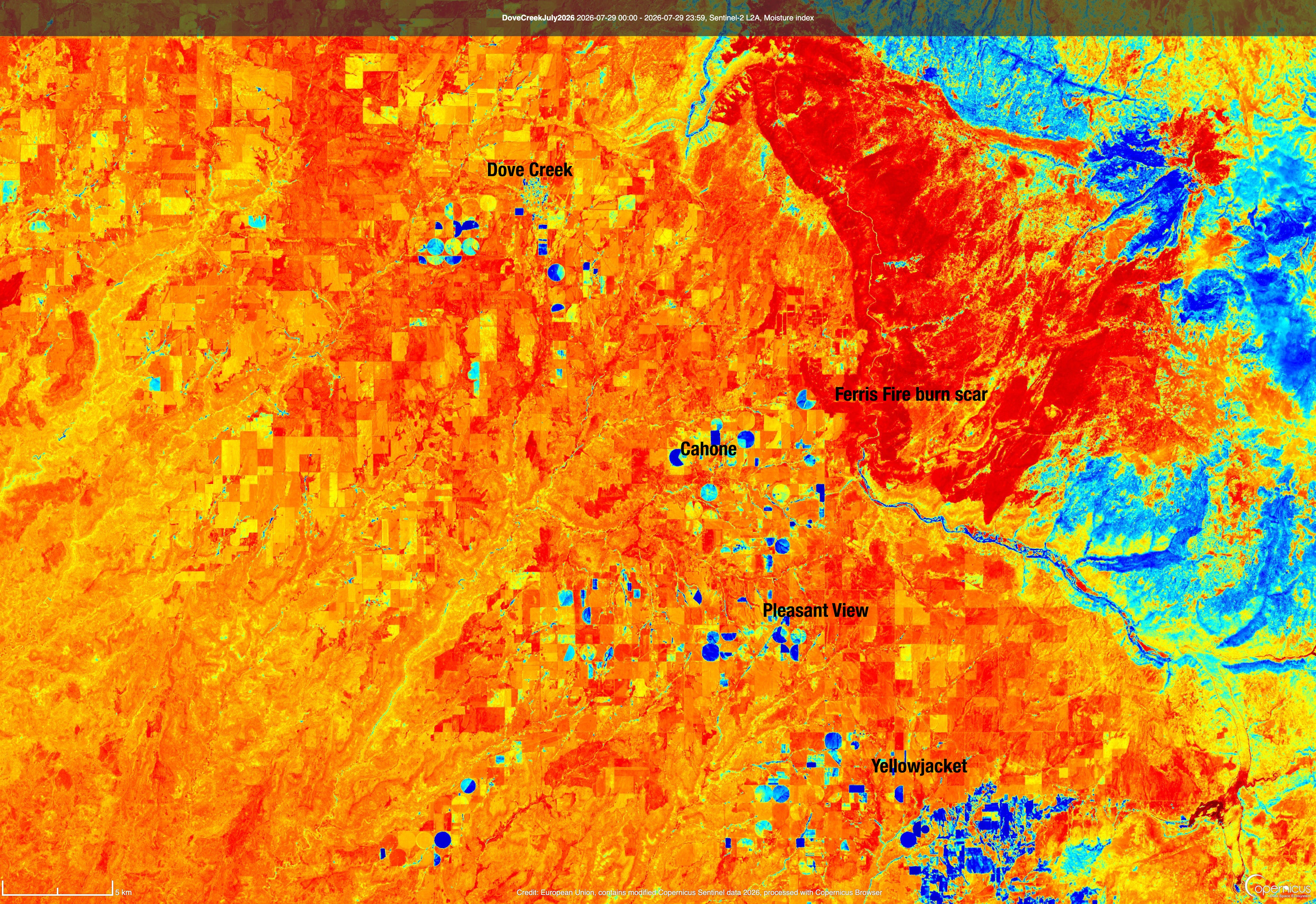
Surface water at Seminoe Reservoir, seen in August 2013, 2020, 2022 and 2026. (European Space Agency)
Trout Unlimited’s Harrington said his group believes the modeling method is sound, but the concern is that the data is too limited. “We’re not saying that the water-quality model itself is bad. We’re just saying if you feed it incomplete information you’re going to get incomplete answers.”
The state’s certificate for the project calls for continuous water modeling going forward, which should help rectify what critics believe is an incomplete dataset, Harrington noted. After all, the state intends to “adapt” its regulatory parameters, and that includes future hydrological conditions. Though it requires rPlus Hydro to begin real-time water quality monitoring “at least two years before project construction,” the DEQ told WyoFile, the agency doesn’t expect that effort to begin until 2028.
Reached for comment, rPlus Hydro didn’t say whether it has begun collecting hydrological data.
“We know that there are low-water years from time to time on the North Platte, and this happens to be one of them,” a company representative told WyoFile via email. “rPlus continues to be committed to the proactive precautions that were built into the Adaptive Management Plan agreed to with the State of Wyoming.”
Local groups, including the Wyoming Outdoor Council, have also criticized state and federal analysis for not going far enough to consider climate-change forecasts for the region.
While the FERC acknowledges that “localized droughts are projected to increase by 2040 and … decreasing snowpack will affect both surface water availability and groundwater resources, increasing pressure on water resources,” it concludes in supporting documents that site-specific climate-change projections are “beyond the scope of the study.”
Typically, the commission can license hydroelectric facilities for up to 50 years, while rPlus Hydro asserts it can reliably operate for beyond 75 years. That raises the stakes to ensure that permitting and regulatory parameters today account for what could be a drastically different environmental future for the region, Harrington said.
“Whether this drought is persistent, or they come every decade, this is the future we should be preparing for,” Harrington said. “The reality of low-water years is here. It seems like we can count on less and warmer water in the North Platte.”
Congressional plea
In a July Senate Committee on Energy and Natural Resources hearing, U.S. Sen. John Barrasso listed concerns he’s heard from constituents regarding the Seminoe project, including its potential impact on what he described as “one of the most legendary trout fisheries in Wyoming and in the World.” The Republican lawmaker implored FERC Chairwoman Laura V. Swett to “commit to taking a renewed look at the state’s comments and consider their incorporation into your final decision.”
“I know these types of projects have a great impact on communities,” Swett responded. “They’re very emotional for both sides, and I am fully committed to making a measured decision based on the record and working with your staff to arrive at the right choice for the American people.”
Reached by WyoFile for further comment, the FERC replied, “We don’t comment on pending matters.”
Barrasso’s office, however, ensured that it is in communication with the agency regarding the matter.
“FERC followed up with our office after the hearing,” Barrasso’s office told WyoFile via email. “We reiterated Senator Barrasso’s comments on how important it is that FERC take into account the state’s comments regarding wildlife habitat and how important the Miracle Mile is to the people of Wyoming. Senator Barrasso will continue to engage FERC as they make their final decision.”
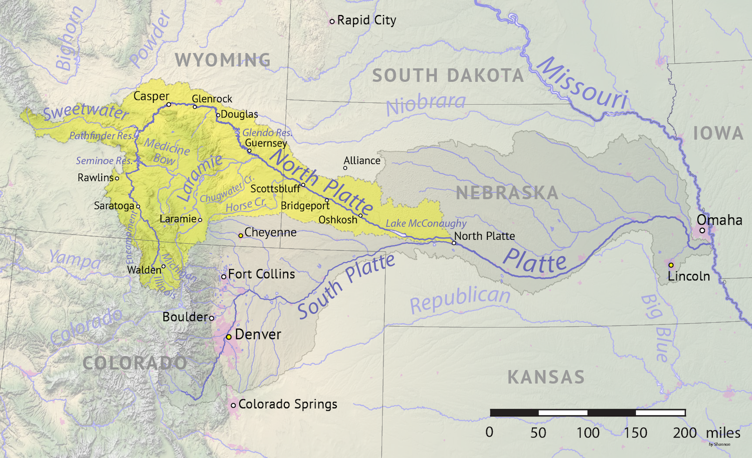
Map of the North Platte River drainage basin, a tributary of the Platte River, in the central US. Made using USGS National Map and NASA SRTM data. By Shannon1 – Own work, CC BY-SA 4.0, https://commons.wikimedia.org/w/index.php?curid=79266632
More than 300 Mountain whitefish were found dead by Colorado Parks and Wildlife on the lower stretch of the Elk River nearly two weeks ago. The fish kill prompted an immediate response by CPW, which implemented a voluntary fishing closure that remains in place.
“While difficult to see, this type of event was expected given the extreme drought conditions this year,” said CPW Northwest Region Senior Aquatic Biologist Ben Felt. “Mountain whitefish are especially vulnerable to high temperatures and low dissolved oxygen levels. Implementing this closure allows CPW to continue protecting this important native species by reducing angler pressure in this area.”
[…]
The shutdown spanned from the Christina State Wildlife Area, about 9 miles north of Steamboat Springs, downstream to its connections with the Yampa River. The fish kill was discovered July 19, and CPW said the cause was extreme drought conditions. During its investigation, CPW measured river temperatures as high as 82 degrees…CPW said temperatures had likely exceeded 80 degrees in the days leading to the fish kill. The Mountain whitefish is one of two native sport fish in Colorado. The other is the cutthroat trout. The fish is endemic to the White and Yampa River watersheds. However, in recent years, due to consistent high temperatures, low dissolved oxygen levels and non-native predatory fish, the whitefish has struggled to survive in the Yampa River. A prior drought in 2002 significantly impacted the Mountain whitefish population. A mandatory fishing closure is in place for the Yampa River for the 0.6 miles between Stagecoach Dam and Stagecoach State Park. Two voluntary closures are also in place on the Yampa River. The first is from the northern boundary of Sarvis Creek State Wildlife Area — about 1.7 miles downstream of Stagecoach Reservoir — extending 3.3 miles through the Bureau of Land Management portion of the river. The second is from the upstream boundary of Chuck Lewis State Wildlife Area to the western edge of Steamboat’s city limit. There is also a low water warning at Yampa River State Park.
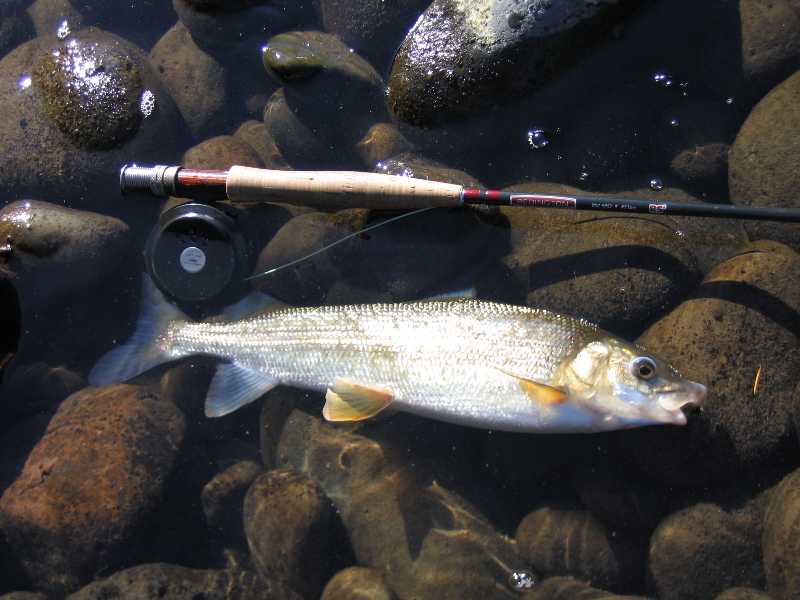
this 16 inch long Mountain whitefish (Prosopium williamsoni) was caught and released in the McKenzie River near the town of Blue River, Oregon on September 1, 2007. By Woostermike at English Wikipedia – Transferred from en.wikipedia to Commons by OhanaUnited., Public Domain, https://commons.wikimedia.org/w/index.php?curid=5099696
On July 13th, the Colorado River District, in partnership with the Colorado Water Trust and the Yampa River Fund, began releasing water from Elkhead Reservoir to mitigate the impacts of extreme drought and critically low streamflows in the Yampa River Valley. Beginning with a release of 10 cubic feet per second, the releases are part of the Yampa River Reservoir Release Program, a 2,000-acre-foot pool first established in 2021 with funding from the Colorado River District’s Community Funding Partnership. The program is designed to reduce drought-related pressure on agricultural producers while supporting river health and aquatic habitat.
“While we’re experiencing exceptionally difficult drought conditions, the story of 2026 is neighbors and water users working together. No single reservoir, organization or water user can solve this alone,” said Hunter Causey, Chief Engineer for the Colorado River District. “By coordinating releases, operations and water use across the basin, we can stretch a limited supply further and provide meaningful benefits for agricultural producers, local communities and the river.”
Below-average snowfall and persistent summer drought have reduced streamflows and increased water temperatures throughout the Yampa River Basin. Releases through the Yampa River Reservoir Release Program are intended to support agricultural water users, help delay or prevent a call on the river during periods of critically low flow, and benefit designated critical habitat for four endangered fish species. Releases are expected to increase in the coming weeks and continue through July.
“The Colorado Water Trust is an environmental nonprofit, and our work is keeping water in rivers,” said Blake Mamich, Programs Director for the Colorado Water Trust. “In a drought this deep, that same mission means showing up for agriculture. Coordinating closely with the River District and the Division of Water Resources, we can time these releases so a single pool of water helps irrigators extend a tough season and keeps water in Yampa for habitat and fish.”
“This is a difficult year for producers throughout the Yampa Valley, and we wanted to be part of a practical solution that helps the broader community,” said Yampa Basin rancher Matt Boeddeker of Lily Park Land & Cattle. “Water users across Colorado are making hard choices and working together to stretch limited supplies, and like them, we hope to help our neighbors complete critical irrigation and reduce the immediate impacts of drought.”
The Yampa River is primarily supplied by snowmelt from the Flat Tops and Gore Range and flows through agricultural areas of northwest Colorado before joining the Green River in Dinosaur National Monument. During dry years, coordinated releases from Stagecoach and Elkhead reservoirs supplement streamflows for agricultural water users, river habitat and endangered fish. The Colorado River District and its partners will continue to monitor streamflow, water temperature, irrigation demand, and habitat needs, and will adjust releases as conditions warrant.
The Moffat County Planning and Zoning Commission voted Wednesday to begin studying how data centers relate to the county’s existing zoning rules, stressing that no data center has been proposed and no decision was made about whether such facilities should be allowed. The commission approved Resolution PC2026-01, initiating a public review of the county’s zoning resolution. It also directs planning staff and commission members to research possible regulations for data centers. The action did not approve or reject a project, change the county’s zoning code, impose a moratorium or commit the county to allowing data centers. Instead, it opened what county Planning Director Candace Miller described as a process to understand the industry and prepare the county in case an application is submitted…Miller said the Planning Department has received no application, speculative proposal or other specific data center plan. She said she brought the issue forward after observing discussions in communities across the country and determining that Moffat County’s zoning resolution does not specifically identify or regulate data centers. The county’s lack of a clear classification leaves unanswered questions about whether different types of data centers would be permitted, conditional or prohibited uses and which zoning districts could be appropriate.
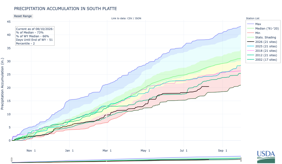
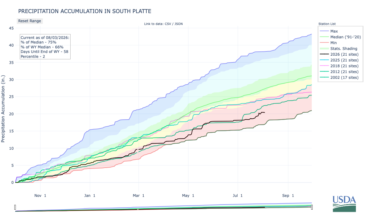
Below is the Precipitation Accumulation in South Platte graph from the NRCS for August 10, 2026. This morning precipitation is at 73% of the median (down 2% one week), and 66% of the water year median (no change one week). There are 51 days left in the water year.
Weather.gov is returning an error this morning. The weather app on my iMac shows chances for precipitation from today through Sunday in the northern and central mountains. It shows chances for precipitation Wednesday through Sunday, down here about 330 miles from Telluride where Butch Cassidy and three other men robbed a Telluride, Colorado bank on June 24, 1889. From the Library of Congress:
This robbery is the first major crime attributed to Cassidy, who would go on to become a notorious bank and train robber, become the leader of the “Wild Bunch” gang, and inspire legends for years to come. Read more about it!…June 24, 1889, Butch Cassidy (Robert LeRoy Parker) and three others rob a bank in Telluride, Colorado. It is the first major robbery attributed to Cassidy…September 17, 1896, Cassidy and the “Wild Bunch” rob a bank in Montpelier, Idaho. In the succeeding years, the outlaws commit several other robberies throughout the Southwestern United States…June 1900, Cassidy considers an amnesty agreement with the governor of Utah, but ultimately does not turn himself in. Soon after, the “Wild Bunch” disbands, but reports of Cassidy continue to surface in the U.S. and South America throughout the early twentieth century.
View northeast Telluride, San Miguel County, Colorado, with San Juans in background and dirt mining roads and streets forming gridlines in town. Creator: Byers & St. Claire Date: 1895-1903. Credit: Denver Public Library Digital Collections
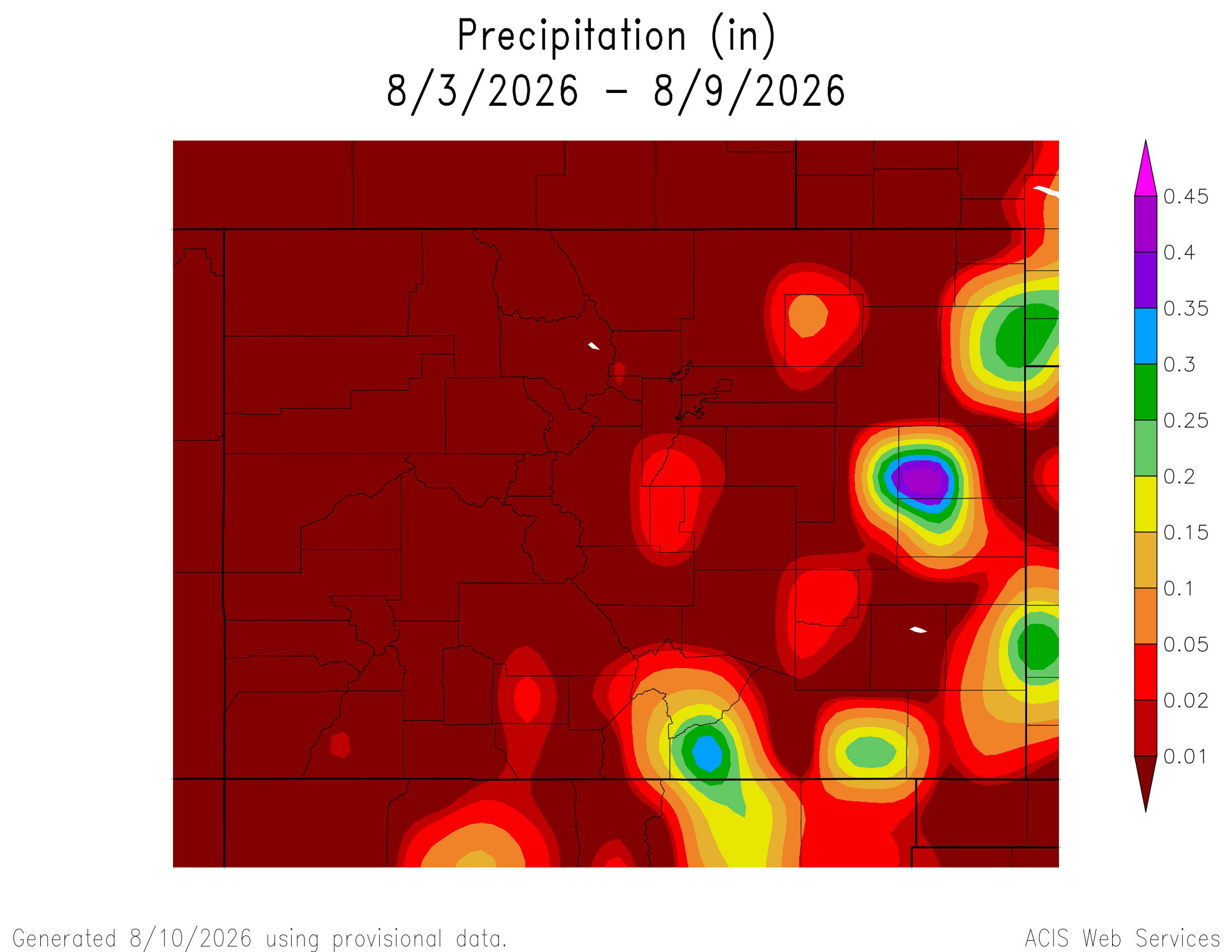
Here’s a look at the 7-Day Colorado precipitation map through August 9, 2026 from the High Plains Regional Climate Center. Precipitation in the South Platte Basin along the Continental Divide of the Americas ranged from 0.00” to 0.05”.
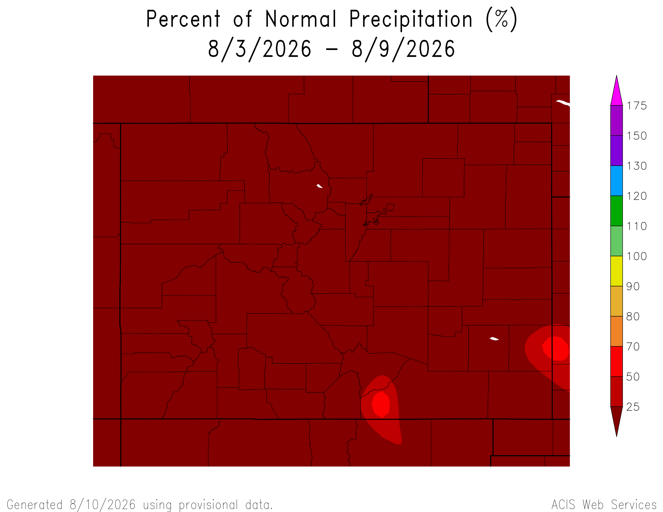
Here’s the 7-Day percent of normal precipitation map through August 9, 2026 from the High Plains Regional Climate Center. Precipitation in the South Platte River Basin along the Continental Divide of the Americas was 0% of normal.
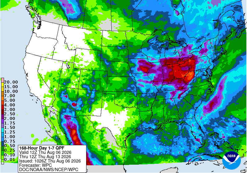
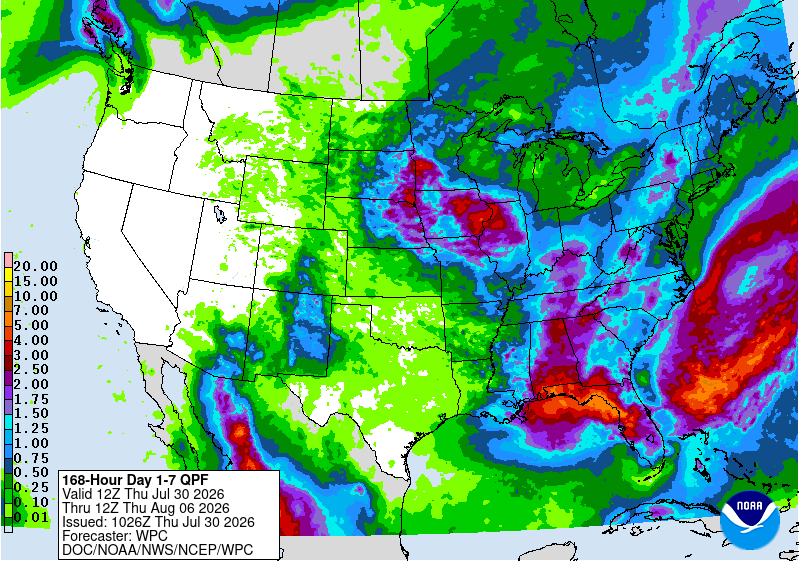
Below is the 7-day Quantitative Precipitation Forecast for the week of August 3, 2026. Precipitation is anticipated for the mountains of the South Platte River Basin and may total up to 4.00″. Viva North American Monsoon!
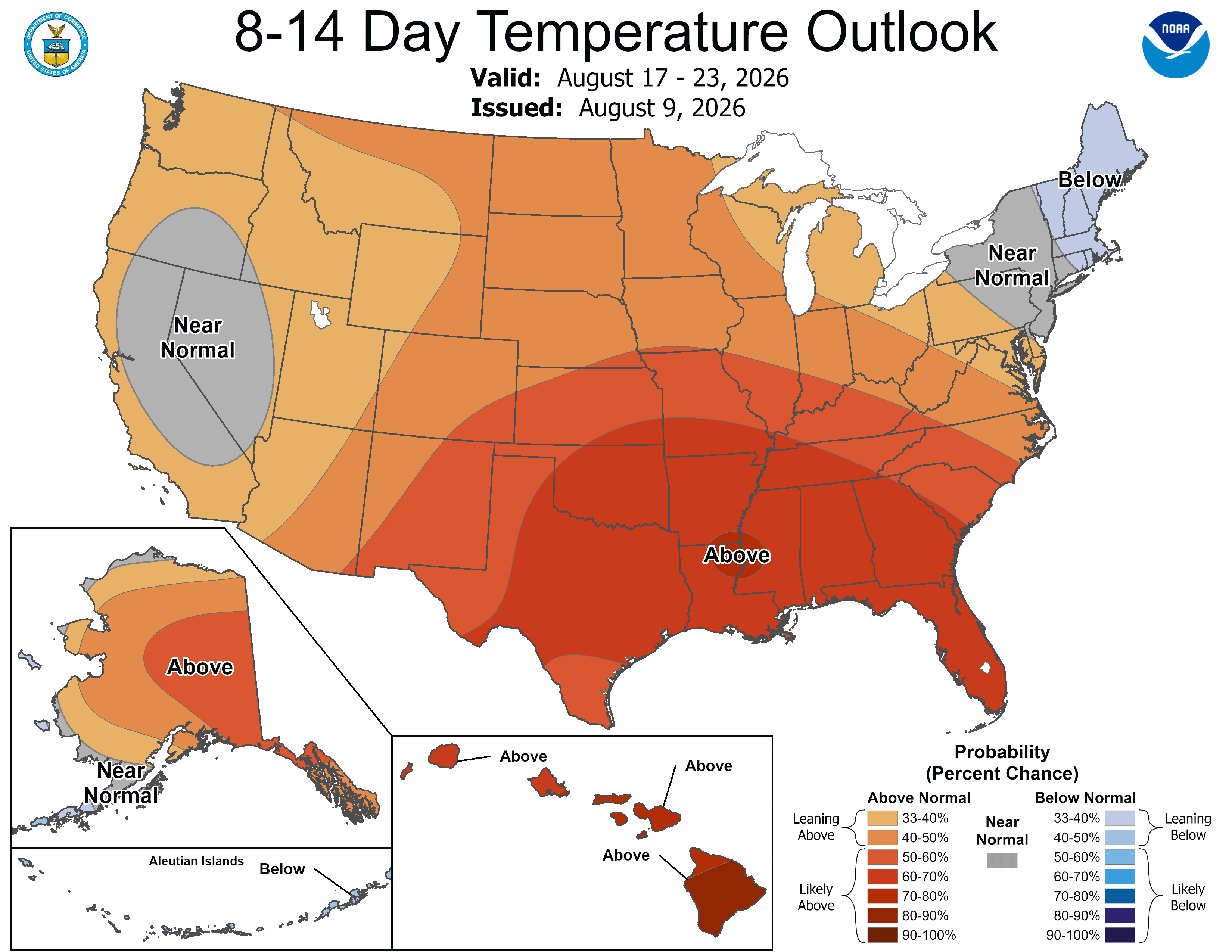
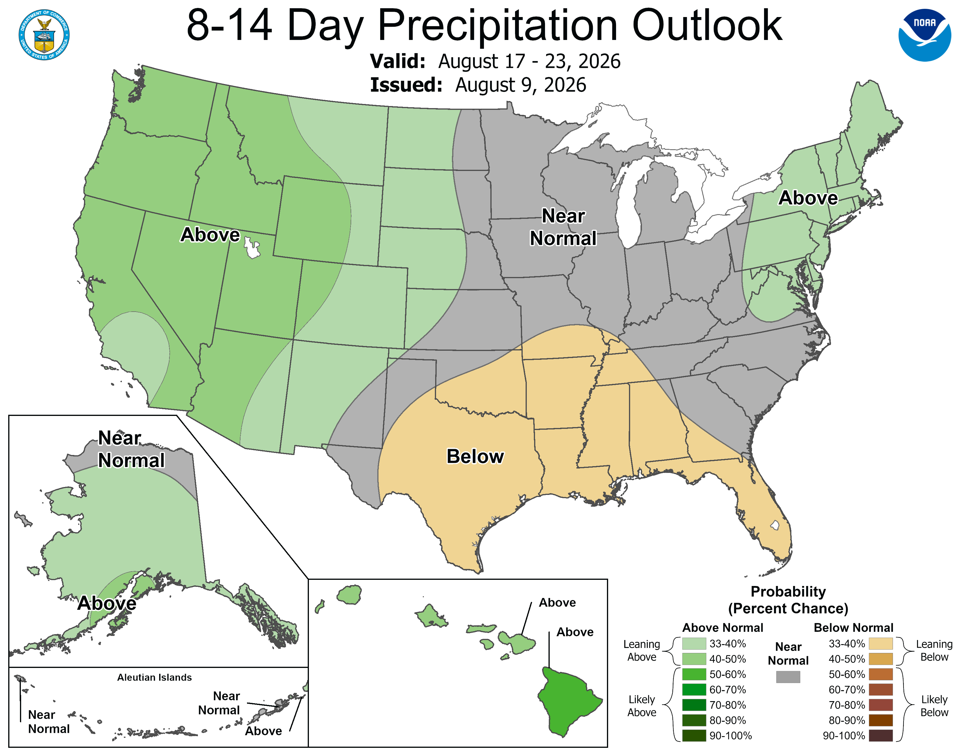
Below are the 8-14 day outlooks from the Climate Prediction Center, issued August 9, 2026, for temperature and precipitation, for the week starting August 17, 2026. The CPC expects above normal temperatures and above normal precipitation for the mountains of the South Platte River Basin.
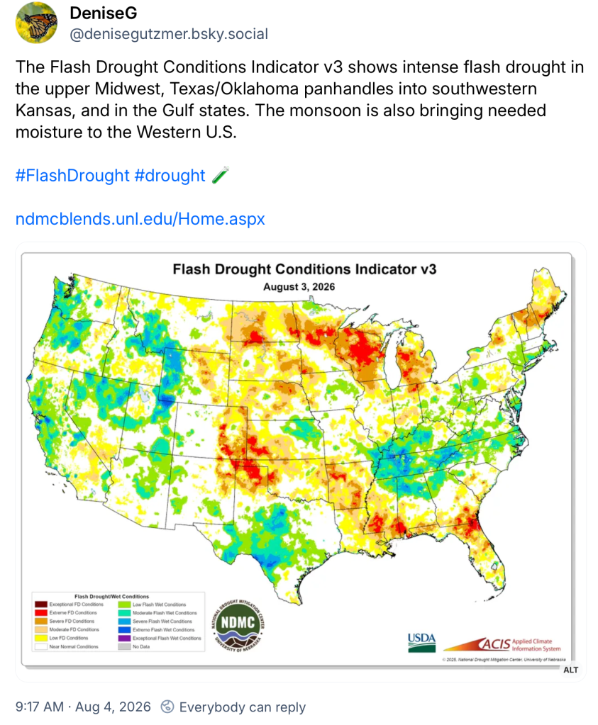
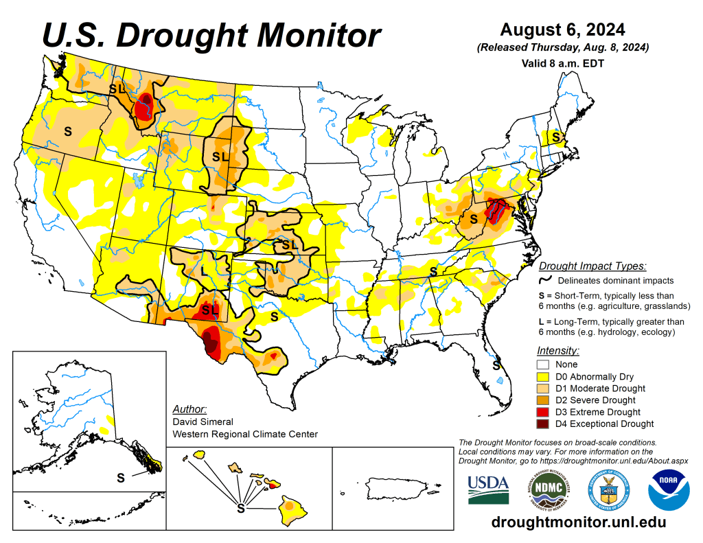
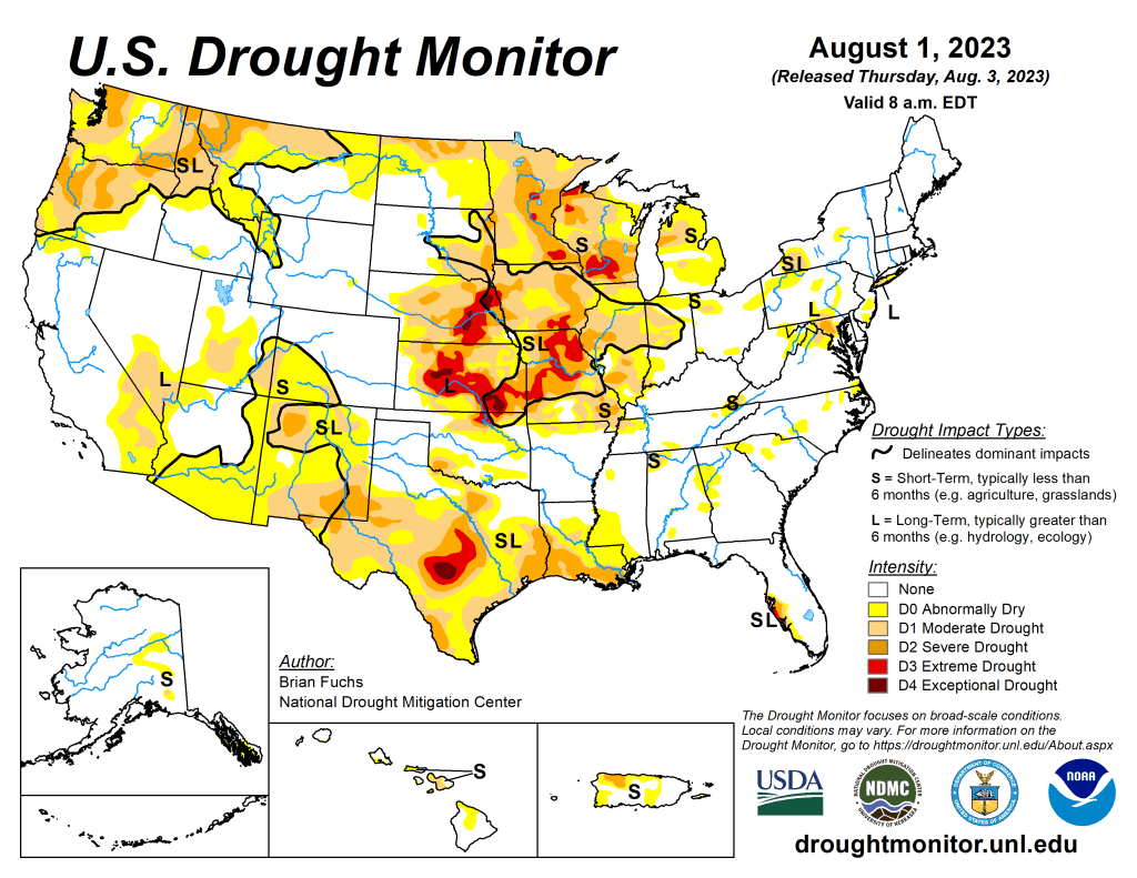
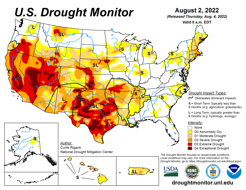
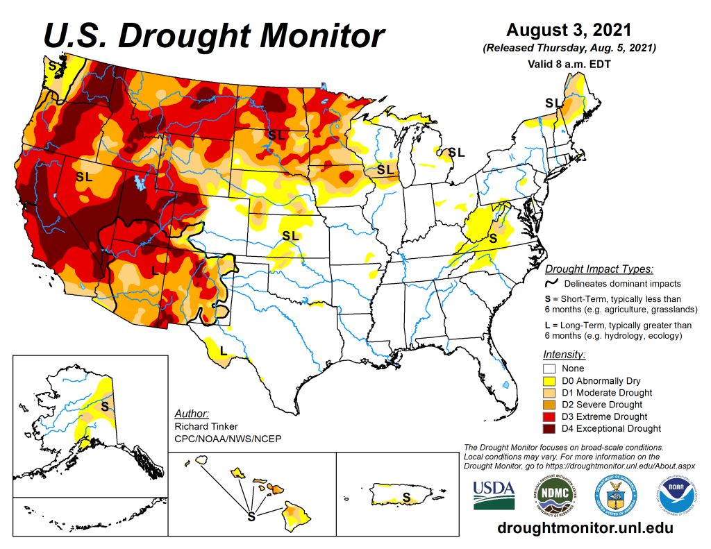
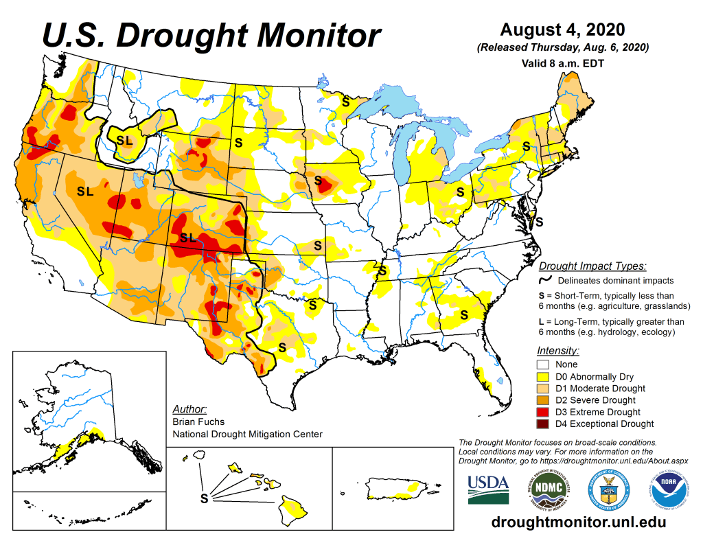
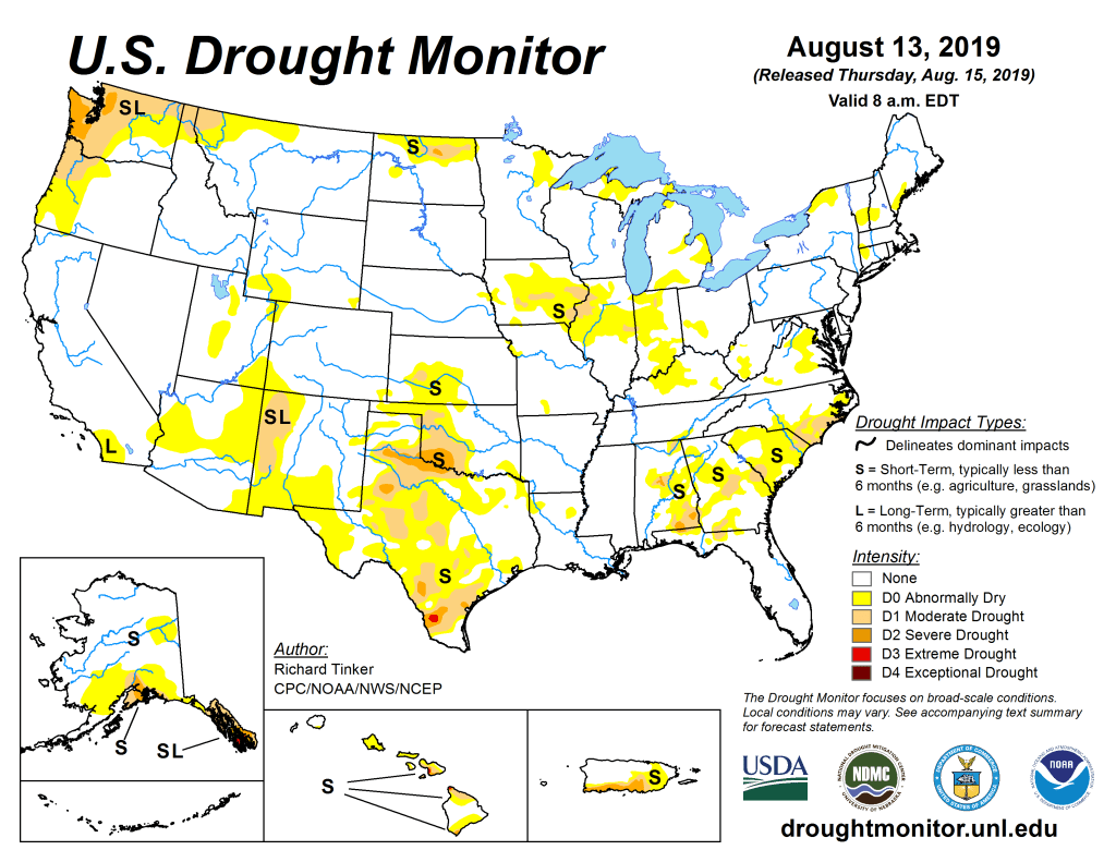
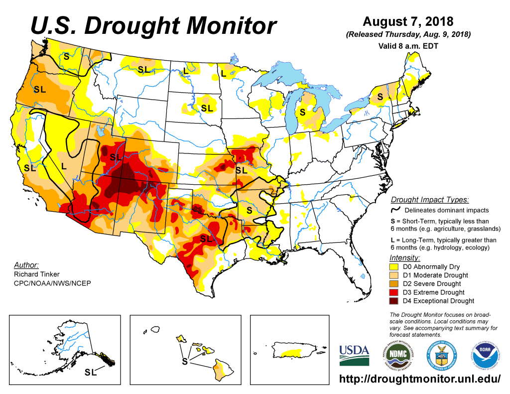
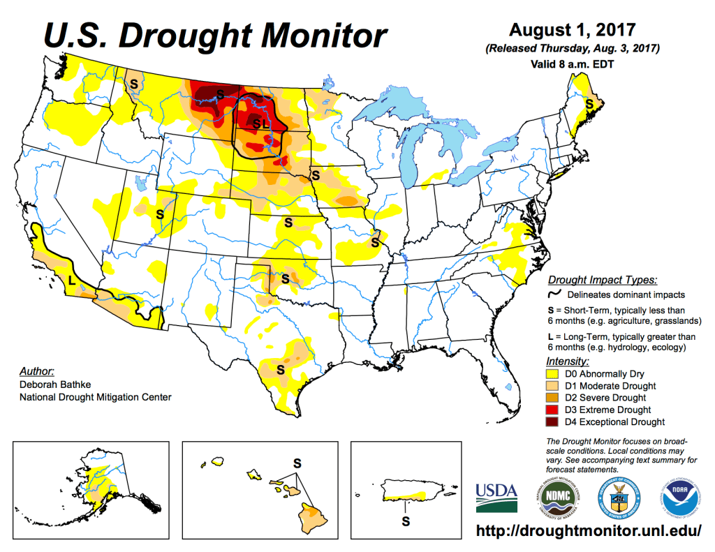
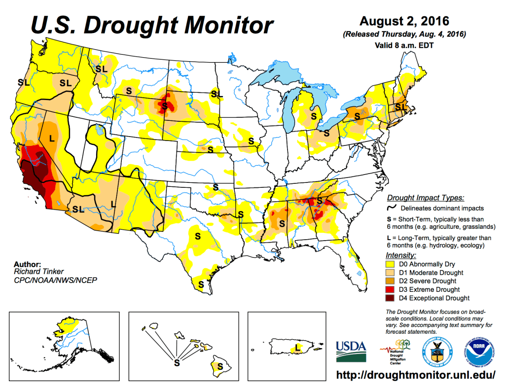
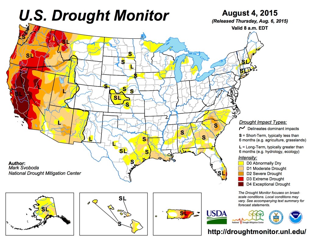
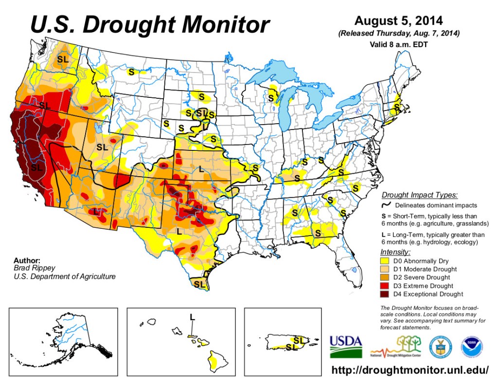
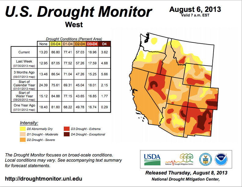
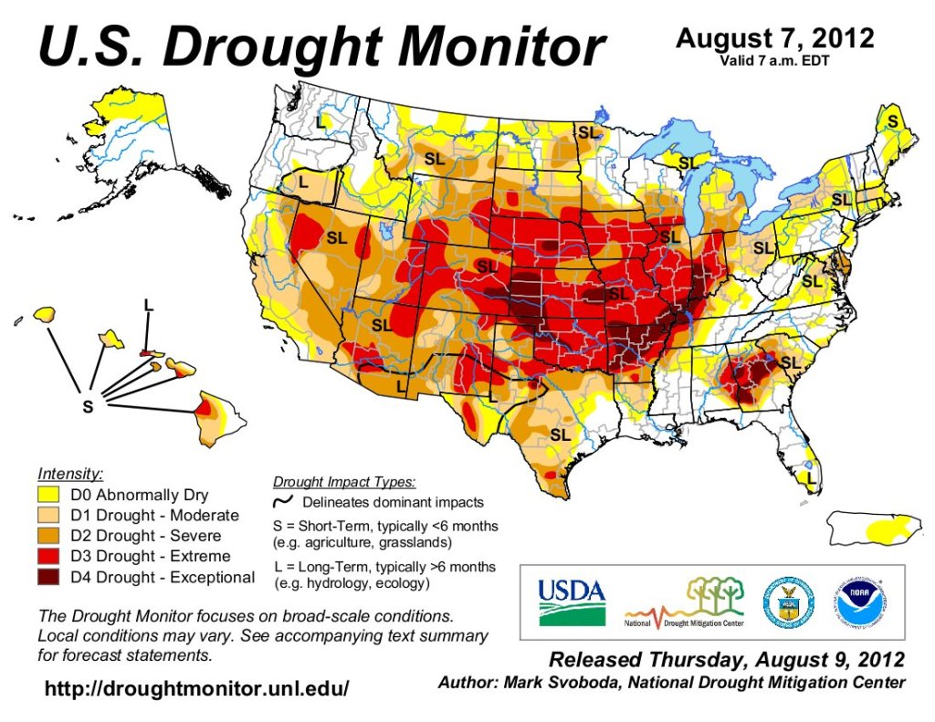
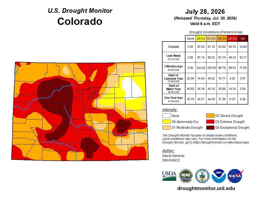
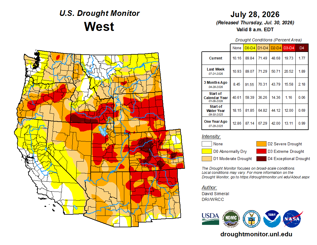
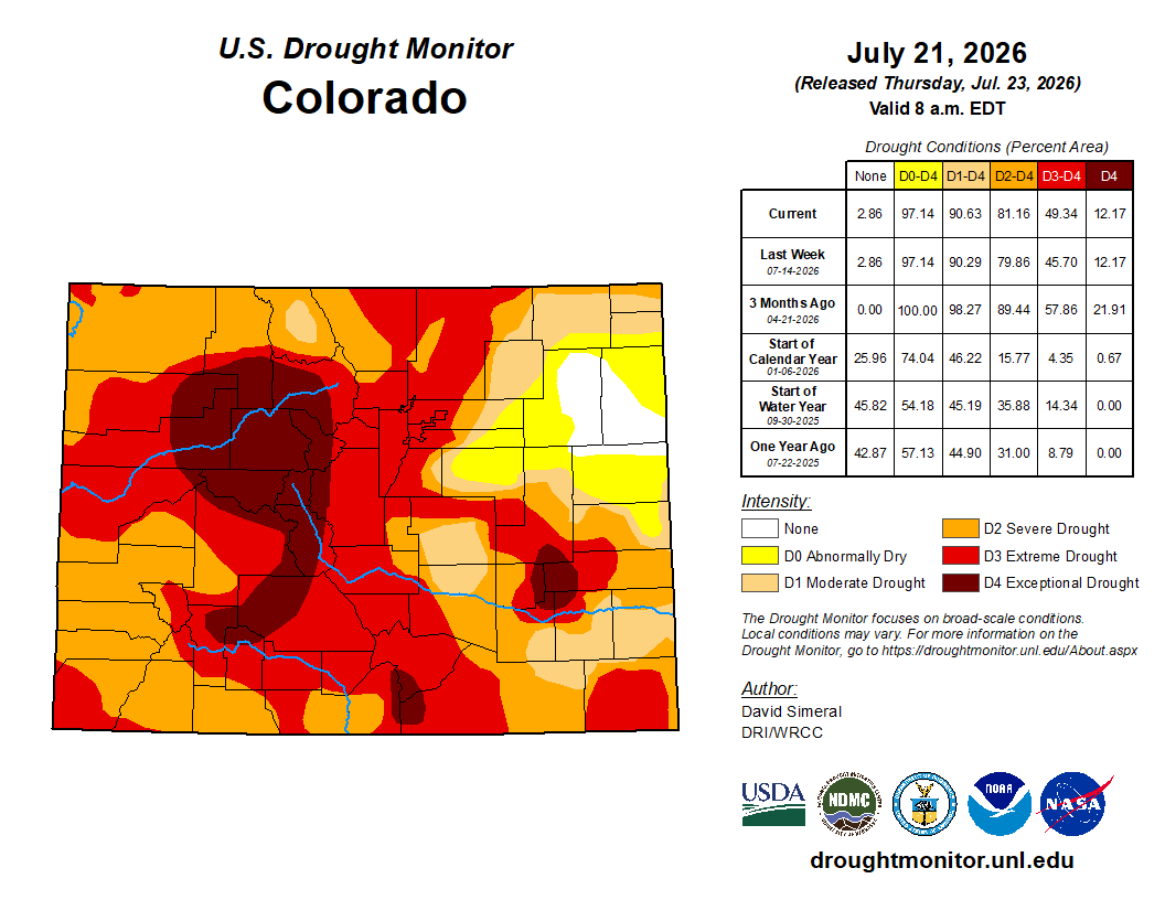
Below is the Colorado Drought Monitor map from August 4, 2026. There were one class degradations in Douglas, Arapahoe, Adams, Denver, Morgan, Weld, and Larimer counties. Drought and abnormal dryness covers 97.29% of Colorado. The South Platte Basin is experiencing Abnormally Dry, Moderate, Severe, Extreme, and Exceptional drought conditions.
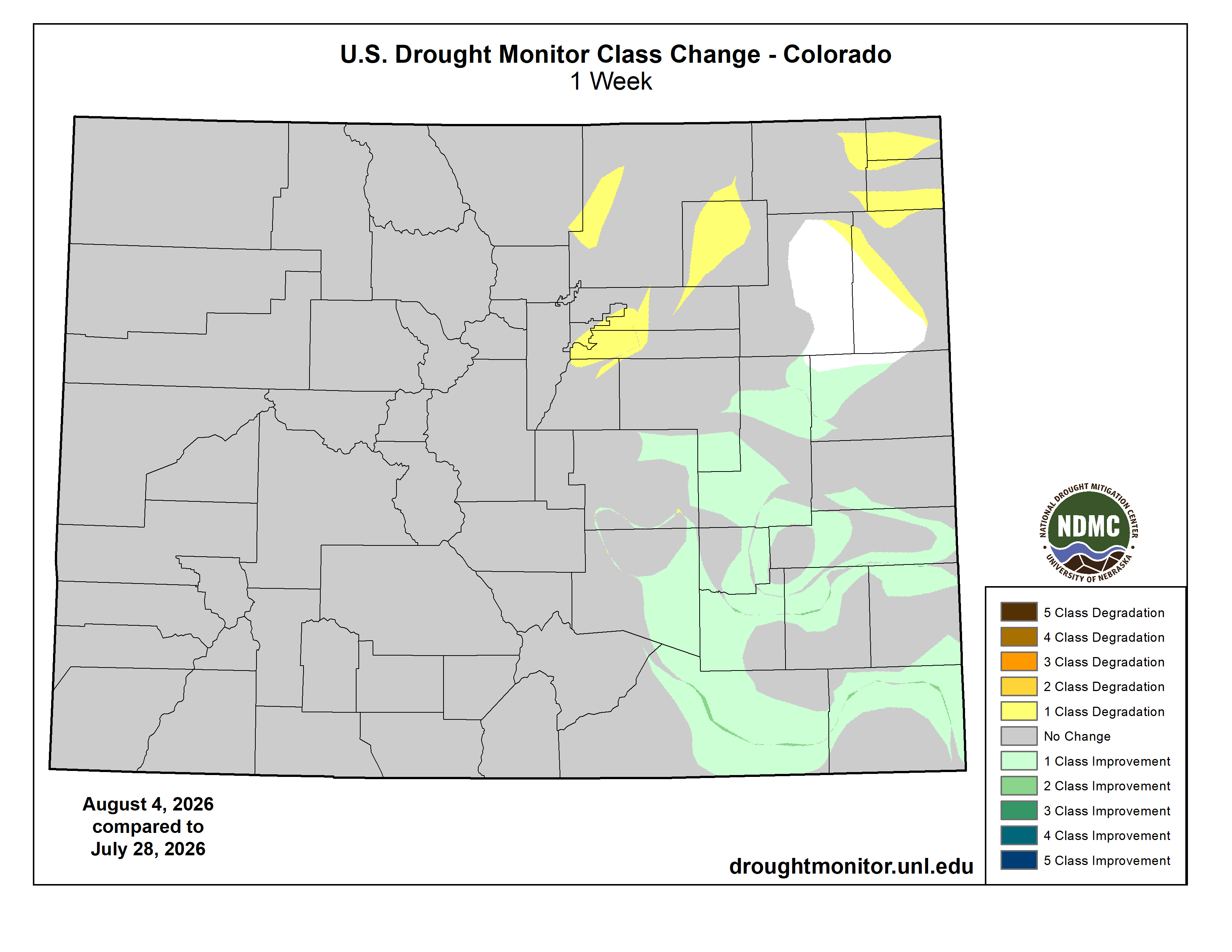
Below is the Colorado Drought Monitor one week change map ending August 4, 2026.
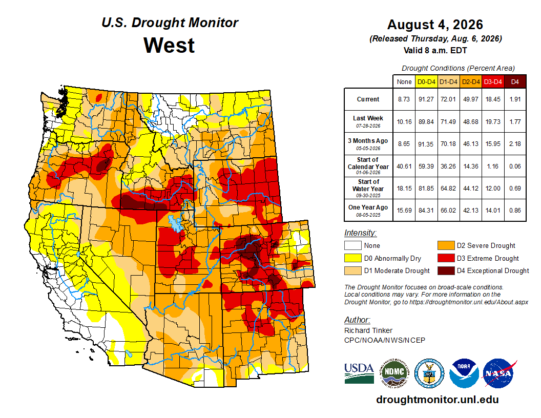
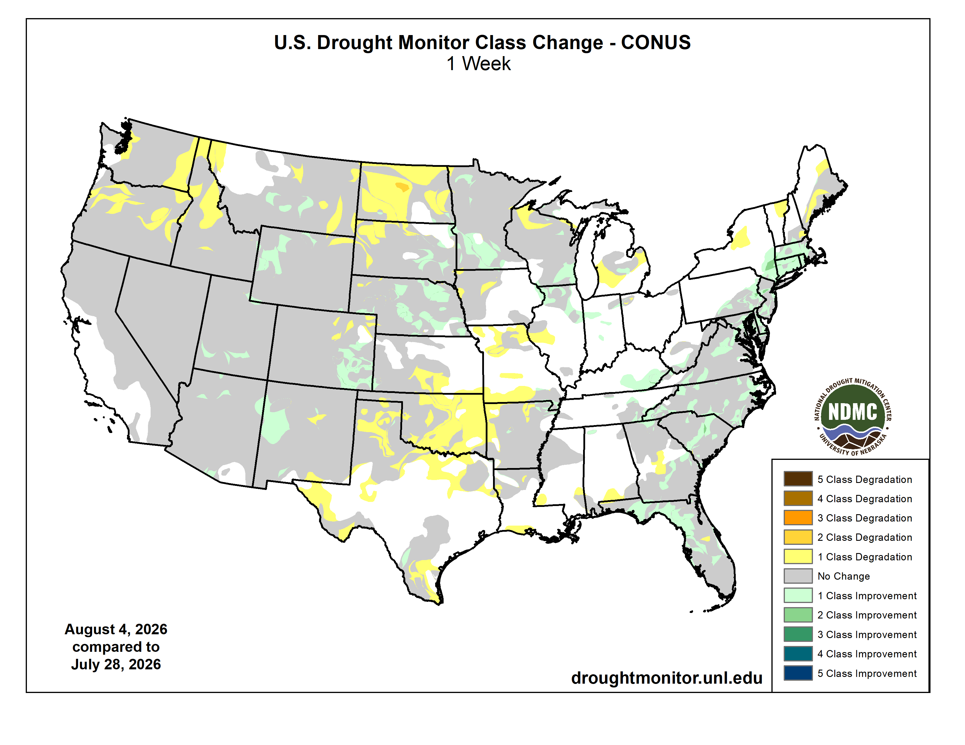
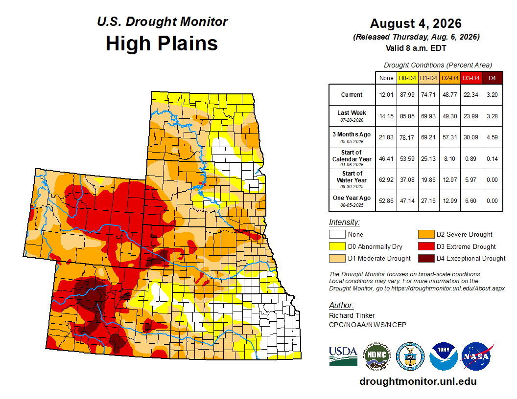
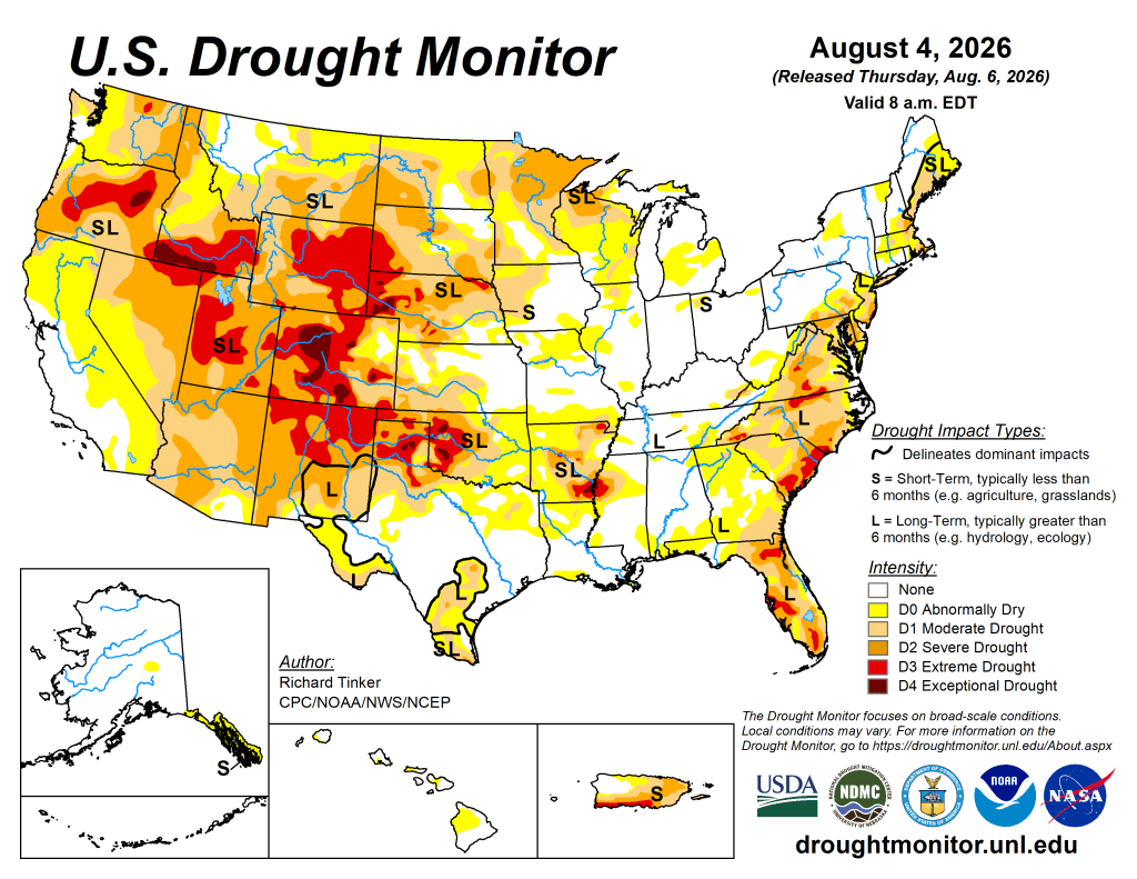
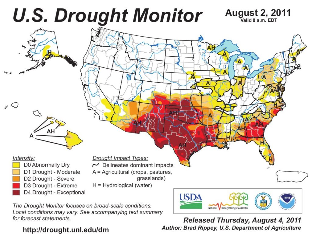
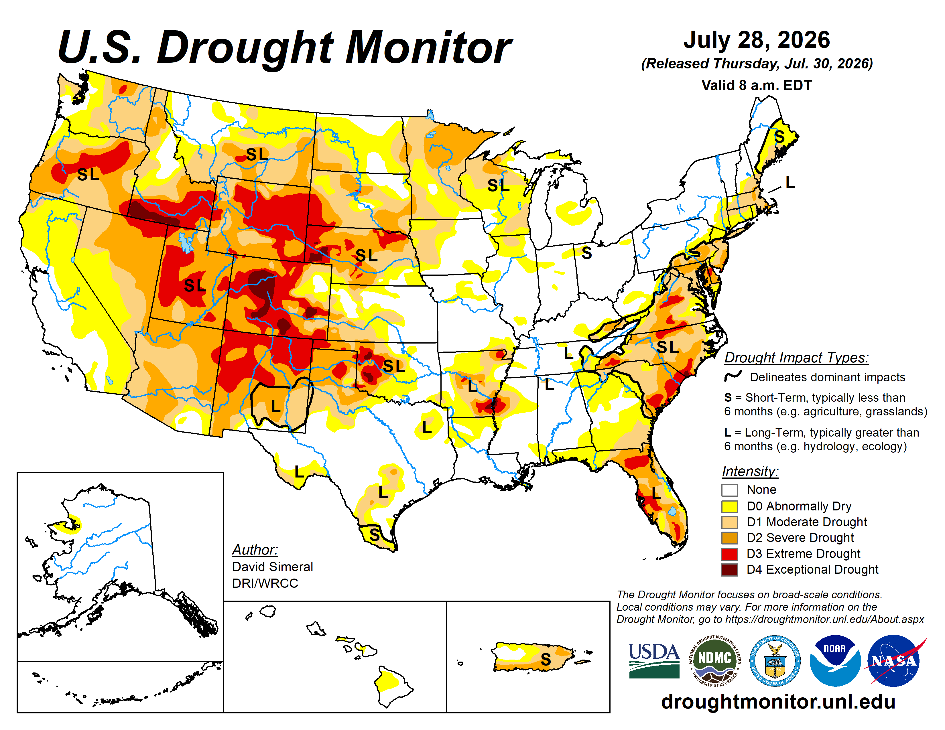
Here’s the US Drought Monitor Map from last week along with the one week U.S. change map.
It’s safe to say that the Trump administration has been waging a war on solar and wind energy, both to spite its political adversaries and to bolster the fossil fuel industries…The data show, however, that Trump’s war on clean energy isn’t going much better than the fight he picked with Iran. For one thing, courts keep slapping down many of his initiatives because, well, they’re illegal. More than that, though, solar and wind generation are making big gains on many state’s electrical grids and, in some cases, are outpacing both coal and natural gas generation, even in fossil fuel strongholds.
It’s safe to say that the Trump administration has been waging a war on solar and wind energy, both to spite its political adversaries and to bolster the fossil fuel industries.
After all, it froze utility-scale solar and wind permitting on public lands; cut federal tax incentives for both utility-scale and rooftop solar; clawed back federal grants for clean energy manufacturing, transmission upgrades, and climate programs; spent $4 billion (so far) in taxpayer funds to pay offshore wind developers to give up their leases; and halted Defense Department reviews of proposed onshore wind developments, thus stalling them indefinitely. That an administration is actively quashing new energy development even as it declares an “energy emergency” to try to prop up the dying coal industry and further pad petroleum corporations’ pockets is especially absurd.
The data show, however, that Trump’s war on clean energy isn’t going much better than the fight he picked with Iran. For one thing, courts keep slapping down many of his initiatives because, well, they’re illegal. More than that, though, solar and wind generation are making big gains on many state’s electrical grids and, in some cases, are outpacing both coal and natural gas generation, even in fossil fuel strongholds.
That’s in part because there were a lot of projects in the pipeline when Trump took office, such as Pattern Energy’s massive SunZia wind power facility in eastern New Mexico, which added a whopping 3.65 gigawatts to the grid when it came online a couple of months ago. Developers have also been scrambling to get projects built before the federal incentives expire, bringing more capacity online. And, even though federal land permitting has slowed, developers have been bringing new projects online on private land, including fallowed farm fields, with surprising frequency.
And there’s a lot more of that on its way: The Westlands Water District in California is moving forward with its Valley Clean Infrastructure Plan, which will develop a 20-gigawatt solar and battery storage project on more than 100,000 acres of water-constrained ag land in the Central Valley. As Land Desk reader Fred Porter often preaches, these increasingly arid times call for farmers to: “Stop irrigating, plant solar, harvest electrons.”
By putting these huge installations on already disturbed former farmland, it reduces the pressure to put them on more sensitive, ecologically rich public lands. Less irrigating will leave more water in the rivers. As solar and wind displace coal and natural gas generation, they’ll also reduce the need for water in those thermal power plants. And, generating more power will offset the electrons lost if/when hydropower generation stops at Glen Canyon Dam and/or Hoover Dam.
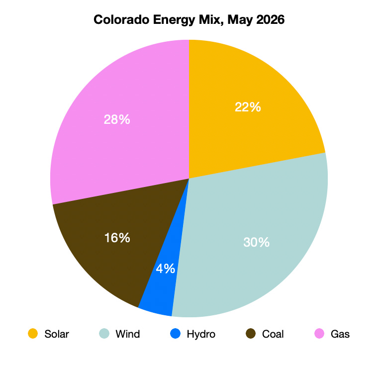
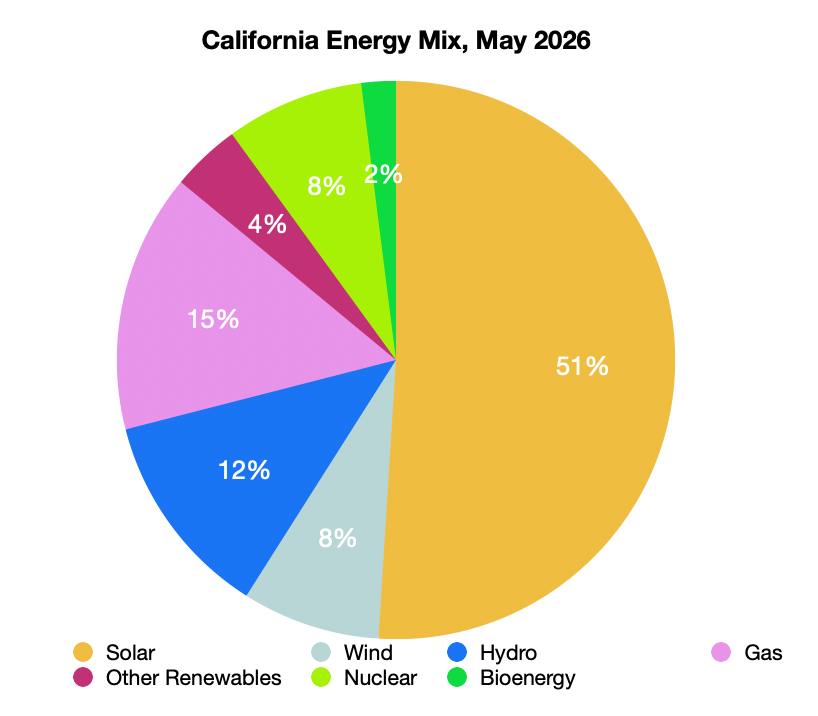
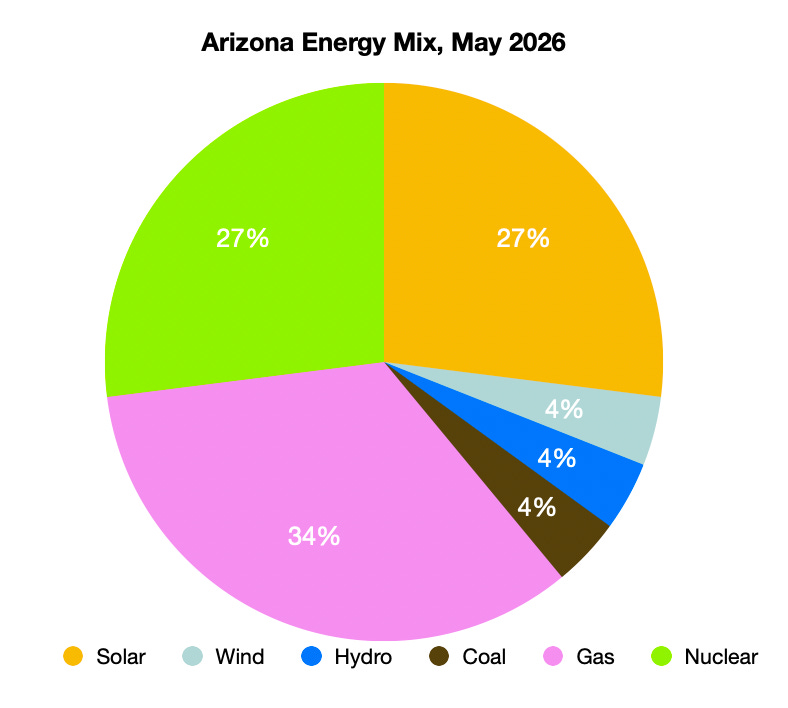
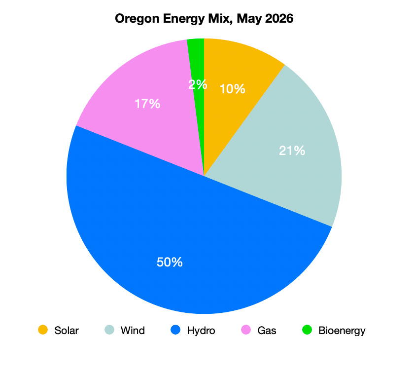
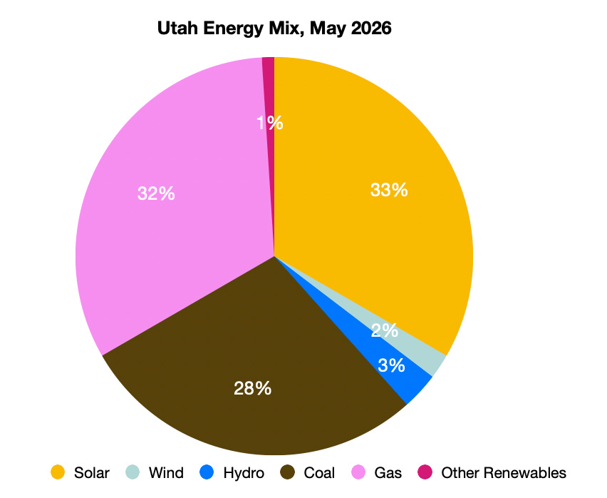
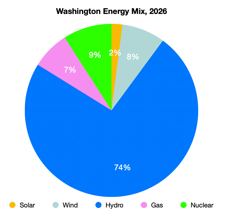
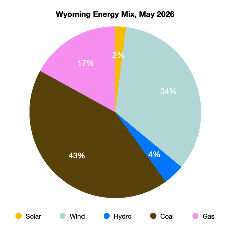
For the blurbs below, I’ve used a snapshot of energy use by state in May of this year, mostly because that’s the most recent data available for all of these states. Keep in mind that electricity demand, and the output of various energy sources, varies from month to month. May is a good month for solar because the sun’s shining, the days are long, and the sky is not obscured by wildfire smoke. Meanwhile, it’s usually not hot enough yet for air-conditioning-related demand spikes.
I’ve only included energy sources that provided 1% or more of a state’s total electricity use that month. In the states below, “other renewables” is geothermal…
California, as one might expect, is leading the clean energy charge. In May of this year, solar generation accounted for 51% of California’s total electricity production, a new world record (wind accounted for another 8%). Meanwhile, fossil fuels — which in California means natural gas — provided less than 15% of the state’s power in May. Hydropower, nuclear, and biofuels filled in the remaining 26%. A surge in grid-scale battery energy storage capacity in the state over the last few years has helped smooth out the solar “duck curve”; plentiful afternoon solar tops off the batteries, which can then discharge in the evening when solar drops off. There are still challenges, however: California’s grid operator continues to curtail solar generation, meaning it forces arrays to shut down or to pay other states to take it, because at times there’s more solar output than the grid can handle.
Solar: 51%
Gas: 15%
Hydro: 12%
Wind: 8%
Nuclear: 8%
Other renewables: 5%
Arizona should be the leader in solar, given how sunny it is, but its clean energy progress has been hampered by Trumpian state lawmakers and utility regulators, who tend to favor fossil fuels for reasons that confound me (I have no idea how energy sources became partisan or why). Still, solar is making huge gains, providing about 27% of the state’s electricity in May, compared to just 12% in 2021. That’s about the same share as nuclear’s, which is somewhat remarkable given that the state is home to the Palo Verde Nuclear Plant.
Salt River Project, the utility that serves most of the Phoenix metro area, continues to add both solar and battery storage. Meanwhile, Arizona Public Service plans to convert its currently shuttered Cholla coal plant near Holbrook to run on natural gas. This was one of the coal plants Trump said would reopen as part of his coal-fetish initiatives. It did not reopen, at least not to burn coal.
Gas: 34%
Solar: 27%
Nuclear: 27%
Wind: 4%
Hydro: 4%
Coal: 4%
Colorado. Just a decade ago, coal-fired generation dominated Colorado’s grid, accounting for about 50% of all generation in 2016. Stronger clean energy policies and the rising cost of coal has unseated the dirty fuel, with wind power taking over the top spot. Coal’s decline, however, has been slowed in the state by Trump administration orders blocking planned plant retirements, and by projections of data center-driven electricity demand increases.
Wind: 30%
Gas: 28%
Solar: 22%
Coal: 16%
Hydro: 4%
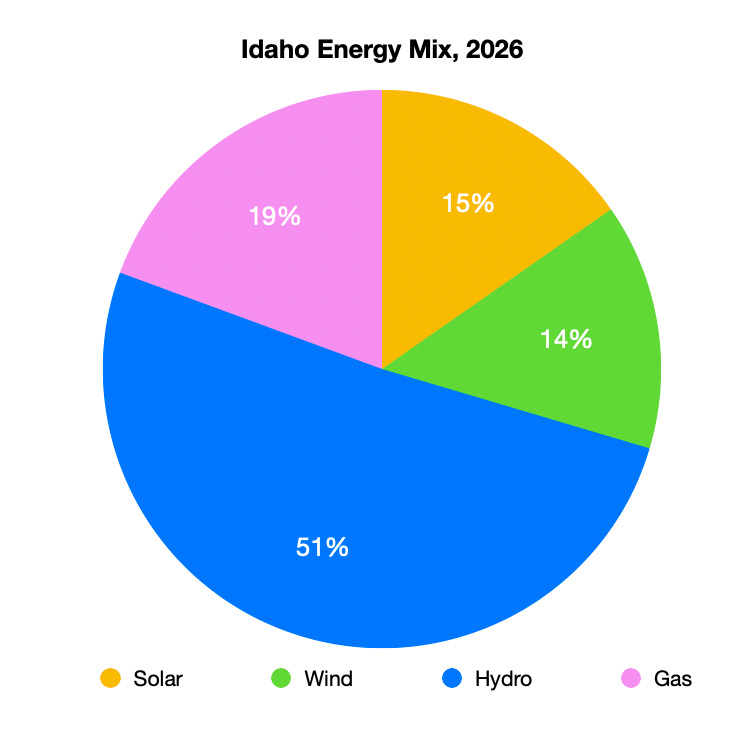
Idaho: Way back in 2006, when coal-fired generation was near its peak in the United States and the Powder River Basin mines were kicking out 1 billion tons of the stuff each year, Ray Ring wrote a story for High Country News about a band of Idaho residents pushing back on a new coal plant. The “West’s New Revolutionaries” ultimately prevailed. And not only did this one facility not get built, but the state has managed to stay off coal altogether. Nowadays, though, rural Idahoans are just as likely to be pushing back against solar and wind installations, the state’s largest utility is hostile toward rooftop solar, and multiple new gas plants are in the pipeline. So don’t expect solar and wind to crowd out other energy sources too soon.
Hydro: 50%
Gas: 19%
Solar: 15%
Wind: 14%
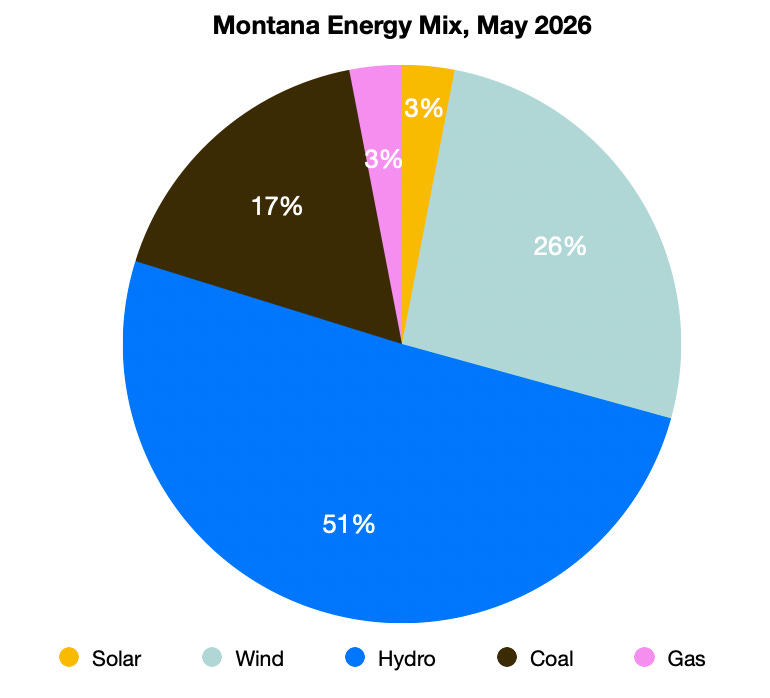
Montana’s state lawmakers and utility regulators have a fondness for fossil fuels. Plus, it’s a big coal mining state and is home to the Colstrip coal power plant, one of the nation’s worst polluters. Nevertheless, coal doesn’t dominate the energy mix here, hydropower does. Wind, however, is making a run for the top spot.
Hydro: 50%
Wind: 26%
Coal: 17%
Solar: 3%
Gas: 3%
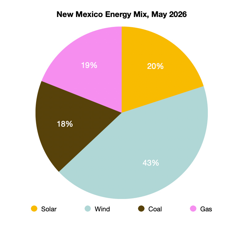
New Mexico produces oodles of methane, i.e. natural gas. The San Juan Basin was once one of the world’s largest gas fields, and in the Permian Basin oil fields the fuel is so plentiful (as an “associated gas” that comes up with the crude) that they just burn it off instead of putting it to use. Still, gas plants generated just 19% of the state’s electricity, while wind and solar combined accounted for 63%. That’s in part because New Mexico has good wind and solar potential, but more importantly it has forward-thinking, progressive policies such as the Energy Transition Act, which not only encourage renewable energy, but also provides a safety net to help coal communities, miners, and power plant workers transition away from the dirty fuel.
Wind: 43%
Solar: 20%
Gas: 19%
Coal: 18%
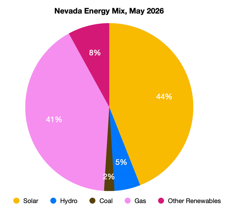
Nevada’s largest utility started moving away from coal years ago, and some of NV Energy’s biggest customers — Las Vegas casino resorts — have demanded clean energy to help them green up their brands. That, combined with Nevada’s large tracts of solar-ready public lands has helped utility-scale solar generation vie with gas as the leader of the state’s energy mix. With several large solar and geothermal projects in the pipeline, shares of those energy sources should continue to grow. The biggest hurdle standing in the way of the Silver State’s energy transition is the Big Data Center Buildup, which threatens to double or even triple overall electricity demand in the next decade or so. NV Energy plans to build more gas generation to keep up.
Solar: 44%
Gas: 41%
Other renewables: 8%
Hydro: 5%
Coal: 2%
Oregon, like other Northwest states, relies heavily on hydropower from the Columbia River’s dams, but it has also added wind capacity at a fairly rapid rate. Like in many other Western states, Oregon’s energy supply is likely to be strained by data center-driven demand.
Hydro: 50%
Wind: 21%
Gas: 17%
Solar: 10%
Bioenergy: 2%
Utah’s Republican-dominated legislature is packed with fossil fuel folks, who have devoted a lot of time and energy trying to keep the coal industry going. Gov. Spencer Cox, meanwhile, is a big nuclear fan, and is courting reactor startups and vying to host a Department of Energy “Nuclear Lifecycle Innovation Campus” that would include nuclear fuel fabrication, enrichment, and radioactive waste storage to add to the existing uranium mining and milling industry.
But for the month of May, at least, solar sat atop the state’s energy mix, bolstered by the new 400-MW Green River solar-plus-storage project, with coal falling to third place. While there’s a lot of talk about nukes, there is real action on the geothermal front in Utah, with Fervo advancing its Cape Station enhanced geothermal project in Beaver County. I’d bet that geothermal’s share climbs long before a reactor comes online in the state.
Solar: 33%
Gas: 32%
Coal: 28%
Hydro: 3%
Wind: 2%
Other renewables: 1%
Washington is a hydropower state, naturally, thanks to big dams on the Columbia River and its tributaries. It’s also one of the few Western states with a notable share of power generated by nuclear reactors. Coal is notably absent, in part due to state policy, despite the Trump administration’s order to keep the Centralia coal plant running past its December 31, 2025, retirement date. Centralia will convert to run on natural gas in coming years.
Hydro: 73%
Nuclear: 9%
Wind: 8%
Gas: 7%
Solar: 2%
Wyoming has become synonymous with coal production ever since the Powder River Basin mines went big time back in the 1970s. It’s also big on coal-generation: In 2003, coal-fired power plants produced 97% of Wyoming’s electricity. Today, the gaping mines in the Powder River Basin continue to produce a lion’s share of the nation’s coal, but the fuel’s stature in the state’s energy mix is declining, while wind power excels.
Coal: 43%
Wind: 34%
Gas: 17%
Hydro: 4%
Solar: 2%
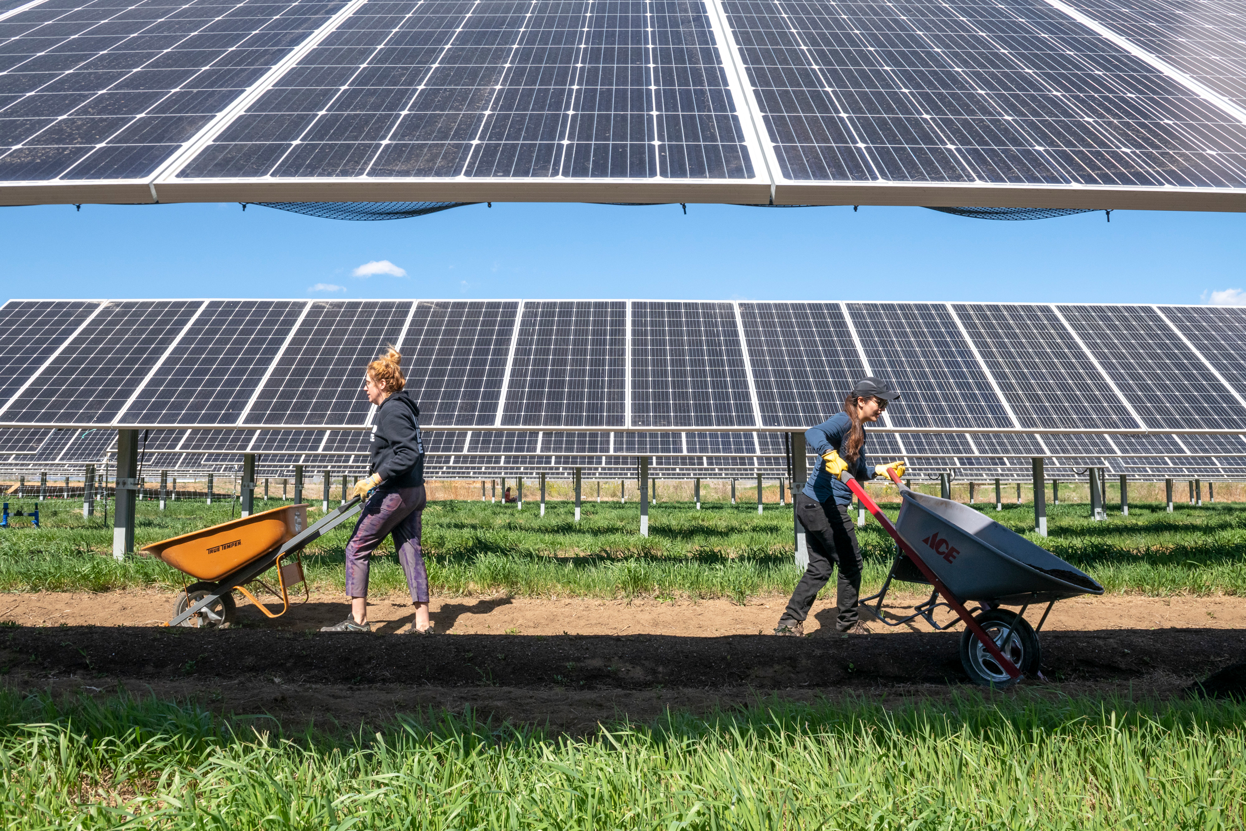
May 6, 2023 – Volunteers with the National Renewable Energy Laboratory’s (NREL’s) ESCAPES (Education, Stewardship, and Community Action for Promoting Environmental Sustainability) program lend a hand to Jack’s Solar Garden in Longmont, Colo. Bethany Speer (left) goes back for more while Nancy Trejo distributes her wheelbarrow load to the agrivoltaic plots. (Photo by Bryan Bechtold / NREL)
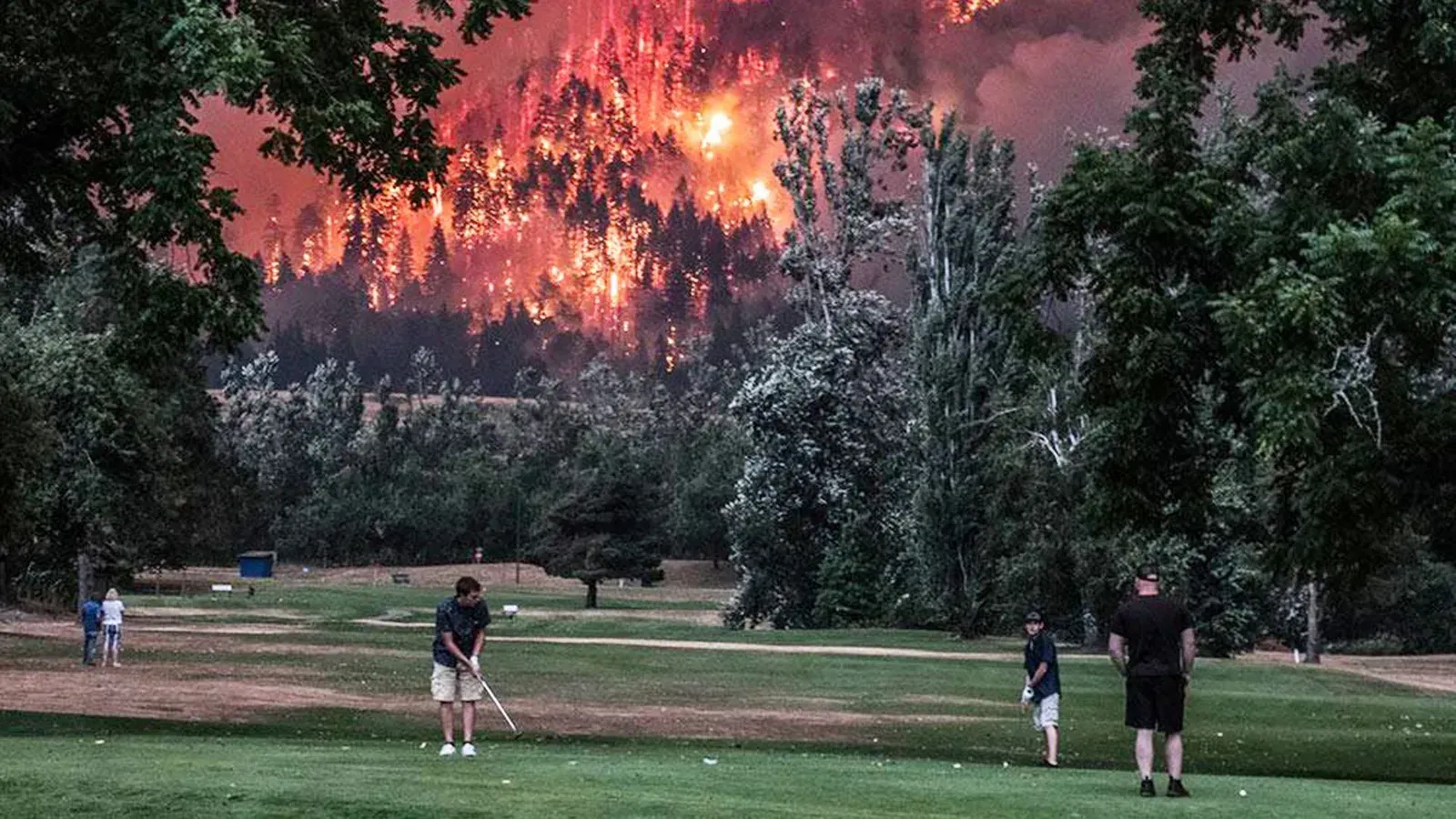
Golfers play while a wildfire rages, 2017. Source: Beacon Rock Golf Course/Facebook.
Please remember, as I first heard friend of Coyote Gulch Laurna Kaatz say, “Climate Change is water change.” Right now there may or may not be elections this fall, and the results may or may not be heeded, but if elections do occur, please vote for candidates that are serious about the Climate Crisis.
As I write, vast regions of Europe are on fire as heatwave after heatwave pummels the continent. The UK has just experienced its driest July ever. Not a drop of rain has fallen in London for over a month. The situation is so bad that even the otherwise reliably climate-denying Telegraph has published articles that say climate change is real and humans are to blame. Previously, sea level rise inundating small island nations and crop failures in sub-Saharan Africa would barely merit a shrug from this right wing publication. Perhaps seeing Bordeaux’s vineyards go up in smoke was for them the moment when climate change got real. Pray mercy for Merlot, and think of the Chablis – something must be done!
Namely, the rapid phase out fossil fuels, while also making herculean efforts to adapt societies to the hotter and more dangerous world we are entering. This adaptation needs to go well beyond sea walls and AC. I am becoming increasingly concerned that what we regard as tipping points may actually be fracture points; the point at which key institutions and systems break from intense and cumulative stress. It’s this failure of social systems that concerns me just as much as Earth system collapse. They have the potential to amplify initial climate shocks via negative social tipping points. At systemic levels this has the potential to lead to what we call derailment risks – efforts to stop future heating are degraded because of lack of institutional capacity given increasing social, political, and economic disruption. Derailment risks are one of the reasons I am so baffled as to how proponents of solar geoengineering can blithely claim that future societies will be able to continue to operate planetary-scale cooling operations for centuries – but more on that in the future.
I am more than baffled at what some sections of the climate science community have been doing in the midst of this crisis. Over the past few years we have seen the quite astonishing spectacle of this community tying itself up in knots trying to decide what constitutes a worst case scenario when it comes to future heating…
You often hear: another world is possible. Well I am here telling you that another world is inevitable. We either decide to stop burning fossil fuels or the Earth system will stop us. We are well beyond incremental, so-called policy relevant pathways. Think wartime mobilisation, and the command of entire economies. None of the climate scenarios capture this. They are all constrained by what politicians would find palatable, which ultimately is whatever maintains economic growth. This means it is still very much business as usual when it comes to our reckless meddling with the Earth’s climate.
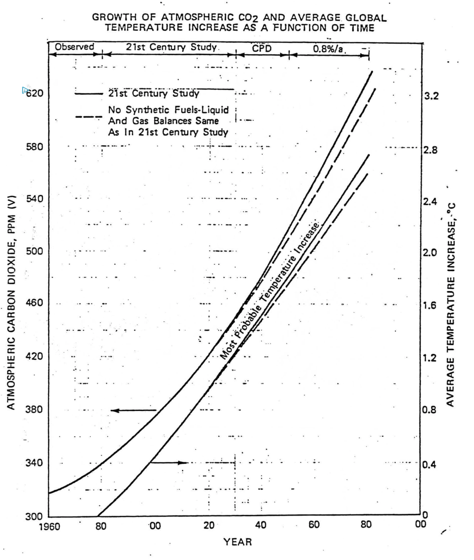
Exxon’s private prediction of the future growth of carbon dioxide levels (left axis) and global temperature relative to 1982 (right axis). Elsewhere in its report, Exxon noted that the most widely accepted science at the time indicated that doubling carbon dioxide levels would cause a global warming of 3°C. Illustration: 1982 Exxon internal briefing document
This article originally appeared on Inside Climate News, a nonprofit, non-partisan news organization that covers climate, energy and the environment. Sign up for their newsletter here.
Water users in the American Southwest confronted on Friday the strong possibility that cities and farms in the region must reduce Colorado River use by hundreds of billions of gallons after the Trump administration released a new management plan for the coming decade.
The document, published by the federal Bureau of Reclamation, outlines a 10-year management approach that could adjust to changing hydrological conditions that affect the river’s flow, with operations updatable every two years. The agency proposed cuts in water allotments originally suggested by Arizona, California and Nevada, which make up the river’s Lower Basin. Colorado, New Mexico, Utah and Wyoming, the region’s Upper Basin, could make voluntary conservation measures.
Interim guidelines and drought contingency plans agreed upon by the basin states in 2007 and 2019 are set to expire in 2027 and negotiations for a new agreement due this year have stalled, with the states missing repeated deadlines to come to a consensus.
But the Bureau of Reclamation operates much of the river’s infrastructure, including the Hoover and Glen Canyon dams, which form Lake Mead and Lake Powell, the nation’s two largest reservoirs. A federal record of decision finalizing operations on the river for the next two years will follow the final environmental impact statement Reclamation released Friday.
“This plan strikes a balance between flexibility and predictability for the Colorado River system that is vital to the 40 million people who rely on it given unprecedented hydrologic conditions and the potential for considerable impacts on water users,” said Andrea Travnicek, Interior’s assistant secretary for water and science, in a statement accompanying the plan’s release. “It also allows a new flexibility to respond to changing conditions and potential consensus.”
The agency is considering releases from Lake Powell, the reservoir near the border of Utah and Arizona that delineates the upper and lower basins, ranging from 5 million to 12 million acre feet to the downstream states (one acre foot can supply about two to four households for a year). The Lower Basin, including Mexico, could take steep cuts in their water allocations, potentially losing 1.5 million acre feet in both 2027 and 2028.
Under such a scenario, Arizona would lose 760,000 acre feet of its allotment from the river, California 440,000 acre feet and Nevada 50,000, following a proposal submitted by the Lower Basin.
But beyond 2028, Lower Basin cuts could reach up to 3 million acre feet.
The Arizona Department of Water Resources called that figure “unacceptable” in a statement published online. “Such reductions would devastate Arizona’s water users and its economy,” the agency said.
Reclamation appears to be seeking voluntary Upper Basin reductions of up to 200,000 acre feet, and discussed moving water from federally managed dams in the basin downstream, as hydrology allowed.
“The proposal responds to a fundamental reality: the Colorado River no longer reliably produces enough water to support all the uses and expectations built around it,” said JB Hamby, California’s Colorado River Commissioner, in a statement. “That challenge is shared across the Basin, and addressing it requires specific, measurable reductions in water use by every state.”
A spokesperson for the Colorado Department of Natural Resources said the state is “analyzing” the document.
Upper Basin governors said in a statement that they were “encouraged that new operating guidelines will better reflect existing water supply, which must underpin any practicable plan going forward.”
The Colorado River is perhaps the most climate-stressed waterway in the U.S. It provides water to between 35 and 40 million people across seven Western states, 30 tribes and two Mexican states as it wends its way through the Southwest, home to some of the country’s most arid and drought-stricken landscapes. Millions of Westerners also rely on the electricity the Hoover and Glen Canyon dams generate.
The 1922 compact between the river’s users assumed roughly 17.5 million acre feet of water was available to the two basins and Mexico, but the historical average of its natural flow has only been roughly 14.7 million acre feet. That number plummeted to an average of 11.2 million acre feet between 2020 and 2024, according to provisional data from Reclamation.
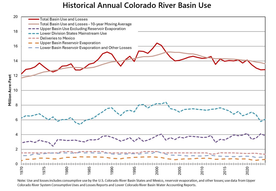
In that same time period, the agency calculated average use and evaporative loss across the basin at just over 13 million acre feet.
“The operational ranges that Reclamation put forward, they’re the right things that we need to be doing in order to fix the supply and demand imbalance,” said John Berggren, regional policy manager at Western Resource Advocates. “But it is just a range, and what they actually do over the next two years or within any given year, that will matter if they’re actually gonna be able to bring the system back into balance.”
Berggren hopes the short-term certainty this plan provides can unstick negotiations between the states.
“I hope [the basin commissioners] don’t just keep doing what they’ve been doing for the last two or three years, ’cause that clearly hasn’t worked,” he said. “I hope they try and take this opportunity to change things up. Let’s try something new and hopefully get to a seven-state agreement.”
Reclamation’s final environmental impact statement was initially supposed to codify the management plan the basin states have yet to agree on. Though deadlines for those negotiations have come and gone, Reclamation is still holding the door open for a deal, which is widely regarded as the most productive path to a durable long-term operating agreement for the river.
“Let’s try something new and hopefully get to a seven-state agreement.”
Negotiations are stalled over whether cuts should be mandatory across the entire basin. After overdrawing from the river for decades, the Lower Basin now uses less water than it is apportioned, according to federal accounting; it wants to see future cuts shared across the seven states. The Upper Basin, which has never used the full amount of water it is legally entitled to, has fiercely contested demands for it to make mandatory cuts, offering voluntary conservation measures instead. The states that make up that basin contend that variable environmental conditions, such as this year’s record-low snowpack, already limit how much water they use.
Even with some idea of federal management options in place, the absence of a seven-state agreement further increases the prospect of states dependent on the Colorado River suing one another in cases that would be adjudicated by the Supreme Court.
Still, proposing to manage the river in a way that is adaptive to hydrological conditions is “the kind of agreement that we are going to need to really think about long-term how do we live in this basin with much less water moving forward,” said Celene Hawkins, Colorado River program director at The Nature Conservancy.
Hawkins hopes this spurs a seven state agreement “so that, ultimately, we can do really good work for communities and for the river itself.”
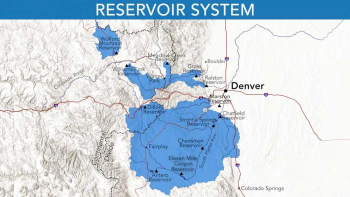
Denver Water relies on a network of reservoirs to collect and store water. The large collection area provides flexibility for collecting water as some areas receive different amounts of precipitation throughout the year. Image credit: Denver Water.
Denver Water’s reservoir storage system, holding water supplies carefully built up over many years, is getting hit hard this summer as hot, dry weather drags on and customers use water.
As of July 31, 2026:
Dillon Reservoir in Summit County, Denver Water’s largest reservoir, was down 20 feet and expected to drop another 8 to 10 feet by Labor Day.
Williams Fork Reservoir near Kremmling was about one-third full; by the end of summer the dam’s hydro turbines won’t be able to produce hydropower.
And Antero Reservoir near Fairplay, considered an emergency drought storage reservoir, was dry after the water was moved out of it in May and June.
Overall as of July 31, Denver Water’s reservoirs stood at 75% of capacity, more than 20 percentage points down from the 96% they’re normally full at the end of July.
And reservoir levels will continue to drop as customers use water.
By April 1, 2027, right before the start of next year’s runoff, Denver Water’s reservoirs are expected to be merely 60% to 62% of capacity — the lowest they’ve been on April 1 since the 2002-2003 drought.
“Denver Water’s robust reservoir system serves as our water ‘savings account,’” said Nathan Elder, Denver Water’s manager of water supply.
“This year we are making significant withdrawals from our savings — and we don’t know how long the hot and dry weather conditions will last, or what this winter’s snowpack will look like. We need customers to do their part and reduce water use inside and outside, so that we won’t need to implement even more drastic restrictions.”
In order to stretch existing water supplies, Denver Water’s mandatory drought restrictions this summer limit outdoor watering to two assigned days per week. The utility’s regular summer watering rules also remain in effect, including no watering allowed during the day between 10 a.m. and 6 p.m. (Check assigned days and watering rules here.)
See how far Dillon has dropped:
Reservoirs play a critical role during droughts, as the stored water that was saved in the past is used to get through dry years.
In July, Denver Water customers used an average of 282 million gallons of water every day. In the winter, when there is no outdoor watering, Denver Water customers typically use about 110 million gallons per day.
Here’s a closer look at some of Denver Water’s key reservoirs:
Antero Reservoir
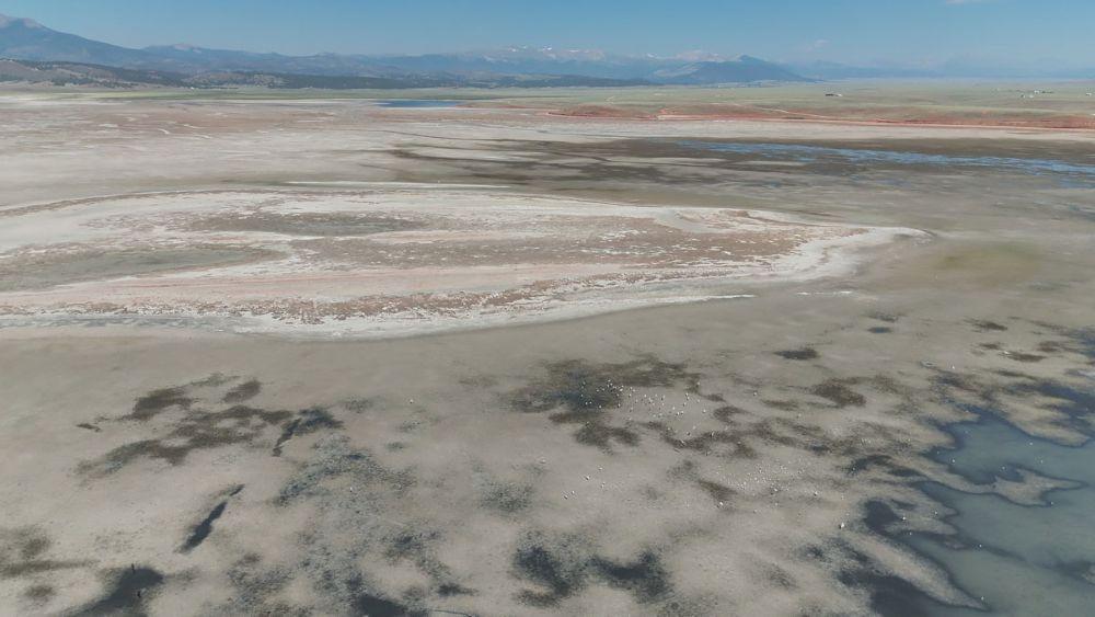
In May and June, Denver Water moved all the water out of the relatively shallow Antero Reservoir in Park County to avoid losing it to evaporation.
Antero’s water was sent down the South Platte River to Cheesman Reservoir, and, due to demand, almost all of that water has been used. Antero Reservoir is considered an emergency water storage reservoir that is used during drought years.
Antero Reservoir in Park County on June 30 without water. Denver Water used the water in the reservoir to meet customer demand due to record low snowpack and runoff. Photo credit: Denver Water.
This is the second time Denver Water has had to use all the water in Antero due to drought. The last time the reservoir was emptied to stretch water supplies in a drought was in 2002.
It is expected to take several years of average or above-average snowpack to refill Antero Reservoir.
Cheesman Reservoir
Cheesman Reservoir, located near Deckers along the South Platte River, opened in 1905.
As of July 31, Cheesman Reservoir was at 71% of capacity. The reservoir would have been even lower without the additional water moved from Antero.
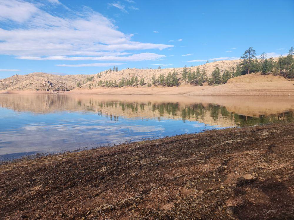
Cheesman Reservoir on July 23, 2026, when it was at 74% of capacity. The reservoir is a critical storage site along the South Platte River near the small town of Deckers. Photo credit: Denver Water.
Cheesman’s water level as of July 31 was 26.5 feet down from full and the reservoir is expected to drop to 54% to 61% of capacity by April 1, 2027. During the drought of 2002-2003, Cheesman dropped all the way down to 29%, less than one-third of its capacity.
Dillon Reservoir
Dillon is Denver Water’s largest reservoir. Located in Summit County, it opened in 1963.
As of July 31, Dillon Reservoir was at 75% of capacity and down 22.5 feet. The reservoir is expected to drop another 8-10 feet by Labor Day.
At the end of July, Denver Water was pulling about 163 million gallons of water a day from the reservoir to meet the water demands of its customers in Denver and surrounding suburbs.
By next spring, Elder expects Dillon will be down to 50% to 60% of capacity. During the drought of 2002-2003, Dillon was down to 48% of capacity.
Dillon Reservoir in Summit County on July 20 looking west at the Tenmile Range in the background and Dillon Marina on the right. The reservoir is down 21 feet and was at 77% of capacity on July 24. Photo credit: Denver Water.
As for the record low? Dillon bottomed out at 35% of capacity in 1978 during a drought.
Gross Reservoir
Gross Reservoir is a critical water storage site in Boulder County. The dam is currently under construction and water levels have been lowered in the reservoir to allow that construction work to move forward safely.
As of July 31, Gross Reservoir was at 53% of capacity.
Gross Dam in Boulder County on June 2, 2026. The dam is under construction as part of the Gross Reservoir Expansion Project. The project is designed to nearly triple the capacity of Gross Reservoir to store more water to get through times of drought. Photo credit: Denver Water.
The Gross Reservoir Expansion Project is designed to nearly triple the size of Gross Reservoir, which will allow Denver Water to store more water to help get through times of drought. The project hit a major milestone in June 2026 when workers placed the last of the roller-compacted concrete steps that make up the higher dam.
Williams Fork Reservoir
The Williams Fork Reservoir, near Kremmling in Grand County, as of July 31 was 36% of capacity and down 52 feet.
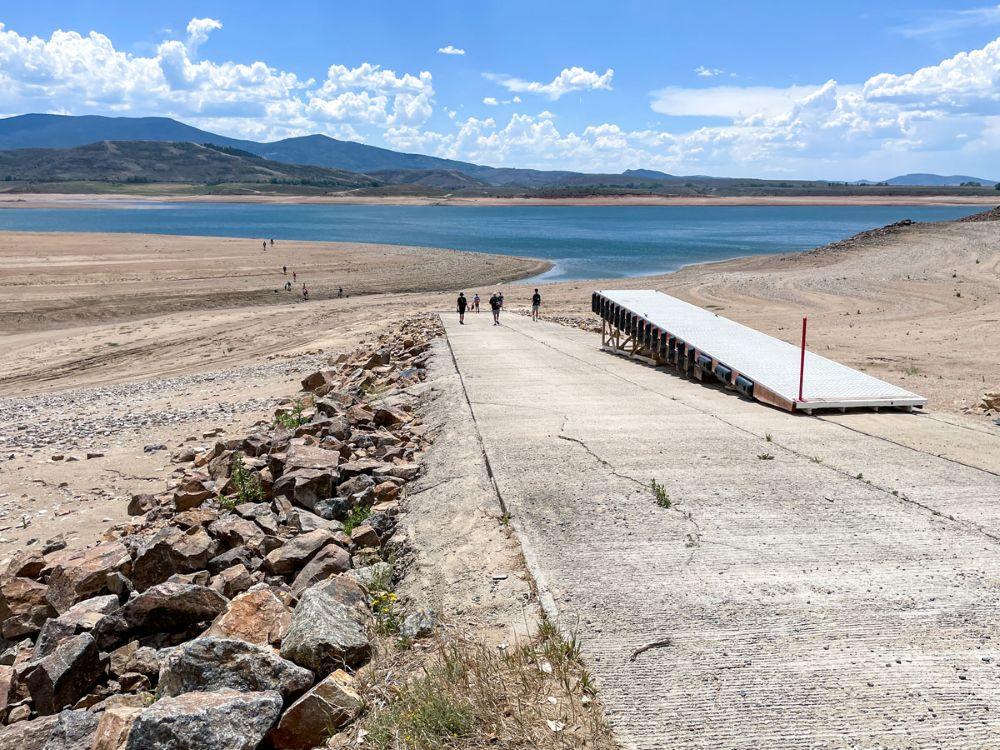
The reservoir’s boat ramp was closed this summer due to low water levels caused by drought. Kayaking and other hand-paddled watercraft are still allowed.
Watch a video of conditions at Williams Fork this summer:
By the end of summer, the water level in Williams Fork is expected to be so low that the dam’s hydropower plant will no longer be able to generate power. The reservoir is expected to drop to 6% to 15% of capacity by April 1, 2027.
A group of visitors walks down the boat ramp at Williams Fork Reservoir on July 20. The ramp was closed this summer due to low water levels caused by drought. Photo credit: Denver Water.
Denver Water does not use Williams Fork to store water for the metro area. Instead, the reservoir’s water is used to exchange, or offset, water that is stored in Dillon Reservoir in order to meet downstream water rights obligations on the Colorado River.
Meadow Creek Reservoir
Denver Water’s smaller reservoirs are also affected by the drought, such as the Meadow Creek Reservoir near Granby in Grand County, a popular dispersed camping and fishing site.
Denver Water took advantage of this year’s low water conditions and further lowered the reservoir to just 6% of capacity in order to conduct an inspection and construction project on the dam.
Meadow Creek Reservoir in Grand County is being lowered this year for a construction project on the dam. Photo credit: Denver Water.
Water released from Meadow Creek was used for irrigation in Grand County, and 350 acre-feet of water was moved to storage in Gross Reservoir.
While Meadow Creek is not a primary storage site, its fate this summer demonstrates some of the challenges and complexity that comes with managing a water system while juggling the impacts of drought, maintenance requirements and the need to deliver to 1.5 million people in Denver and surrounding suburbs.
Looking ahead
While having Denver Water’s overall reservoir system at 75% of capacity as of July 31 may not sound too bad, Elder says customers need to act now to conserve as much water as possible.
And while there has been talk of a strong El Nino, summer monsoon rains and big winter storms on the horizon, Elder notes that “hoping for more rain and snow” is not an actual strategy for managing through a historic drought.
Also, 90% of the water Denver Water collects comes from mountain snow, meaning that even a strong monsoon this summer won’t do much to stem the fall in reservoir levels.
The bottom line is that no one really knows what next year’s water supply outlook will be until next winter — and more critically, until next spring’s runoff season, when the snow starts to melt and water flows into the reservoirs.
Right now, Elder’s team has calculated Denver Water’s water supply outlook through April 1, 2027, right before the next spring runoff begins.
And the team is forecasting that by then, Denver Water — and its customers — will be facing reservoir levels of just 60% to 62% of capacity, the lowest since the 2002-2003 drought.
“We have a strong reservoir system, but we are going through a lot of water this summer and reservoir levels are dropping,” Elder said.
“Every drop counts, and every action customers can take to conserve water inside and outside will help stretch our water supply. This is the time to Use Only What You Need.”
Denver Water’s decade long Use Only What You Need campaign found humor in conservation. Photo credit: Denver Water.
A map being shown around El Paso County by suburban water agencies traces the path of the Loop, a complex $134 million pipeline and pumping project that would allow northern and eastern communities in the county to reuse aquifer water returning to Fountain Creek, and pipe along water rights they have bought up on the southern side of the county. (Provided by Woodmoor Water and Sanitation District)
On Monday evening [August 3, 2026], the Monument town council voted unanimously to begin exiting the multidistrict authority. The Loop is left with just two water district members of the original four after the decision…Proposed in 2022, the Loop would divert water flowing down Fountain Creek, pumping it northward and east around Colorado Springs to districts along the way. Billed as a way to break the reliance of communities on the nonreplenishing groundwater of the Denver Basin, the Loop was first estimated to cost between $160 and $190 million to construct…Town staff recommended the action after hearing that Donala Water & Sanitation District, one of the remaining partners, would also be voting to remove itself from the agreement soon…Cherokee Metro District pulled out of the project in 2024. Interim General Manager Kevin Brown previously told The Gazette the district had to divert resources to remove forever chemicals in its supply before a compliance deadline. Instead of the Loop, Cherokee was going to focus its efforts on securing access to water rights in the Upper Black Squirrel Creek Basin.
Water stored in Colorado’s Denver Basin aquifers, which extend from Greeley to Colorado Springs, and from Golden to the Eastern Plains near Limon, does not naturally recharge from rain and snow and is therefore carefully regulated. Courtesy U.S. Geological Survey.
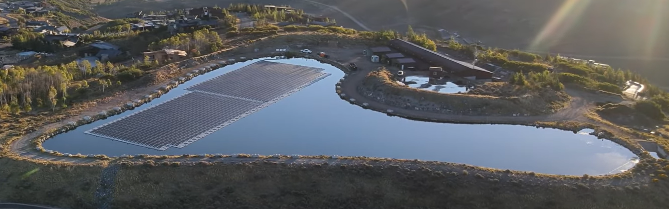
Image of floating solar array at Signal Hill Treatment Plant. The goal is to offset approximately 92% of the electrical usage at that facility. This floating array and the involvement with the Summit County Power Purchase Agreement for electricity from the Elektron Solar project, located in Tooele County, Utah, will get the District to nearly a totally renewable energy usage position. Photo credit: Mountain Regional Water
This coverage is made possible through a partnership between Grist and The Salt Lake Tribune, a nonprofit newsroom in Utah.
Utah’s solar generation eclipsed all other electricity sources for the first time ever in May, the culmination of a slow but steady years-long shift away from coal. Energy experts are calling it a win for the environment and the state’s economy.
Photovoltaic panels in Utah produced nearly 1 terawatt hour in May 2026. That represented nearly a third of all electricity generated in the state that month, according to data from Ember, a global energy think tank. Natural gas generated 32 percent, coal generated 28 percent, and wind 2 percent.
“The trend of more and more solar in Utah is wonderful news for air quality, it’s wonderful news for the climate, and it’s wonderful news for jobs and the economy,” said Dan Schroeder, a physics professor at Weber State University who regularly checks energy data.
Solar also supports nearly 8,000 jobs in Utah, according to the latest information from the Solar Energy Industries Association. The state is home to 132 solar companies, including 54 solar developers and 23 solar manufacturers. Investors committed $1.5 billion to Utah’s solar market in 2025 alone.
Oil and gas extraction, by comparison, accounted for 1,291 jobs in the state in 2025, according to the U.S. Bureau of Labor Statistics. Coal mining accounted for 1,059 in 2023, the most recent year the bureau has data for that industry. Utah had another 1,905 jobs in coal and petroleum product manufacturing last year.
The rise of solar power has helped the state wean itself off a dependence on coal. In 2017, coal generated between 64 percent and 78 percent of electricity in Utah, depending on the month. By 2023, it started accounting for less than half of the state’s power sources in certain times of the year. This spring, it was less than a third.
Electricity generation is complicated, however, and solar won’t represent a third of Utah’s portfolio every month. But with its sunny, dry climate, “Utah still has room to grow its solar percentage,” Schroeder said.
He pointed to California, which saw nearly 51 percent of its electricity generation come from solar panels in May, the most recent month that Ember has data — showing Utah has much more room to grow.
“We’re going to see milestones like this increasingly happen,” said Logan Mitchell, a climate scientist and energy analyst with Utah Clean Energy.
About 51 percent of the new utility-scale electricity generation added to the country’s grid is expected to come from solar this year, according to the U.S. Energy Information Administration. The country is likely to add another 43.4 gigawatts of solar, 24.3 gigawatts of battery storage, and 11.8 gigawatts of new wind power in 2026, compared to just 6.3 gigawatts of natural gas generation and zero new coal capacity.
Some of Utah’s electricity gets exported to other states, and some of its solar farms serve a single customer, like the project in Utah County that has a contract with Meta, the parent company of Instagram and Facebook.
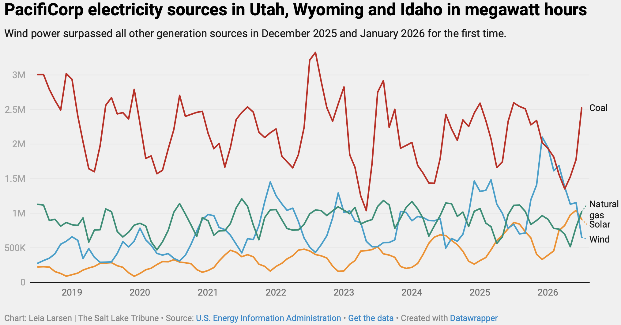
Mitchell pulled the numbers from the state’s largest electricity provider, PacifiCorp, which is the parent company of Rocky Mountain Power. Turns out, another renewable energy source has seen a surge in generation in the region — wind power.
Wind blew past all other energy sources in PacifiCorp’s portfolio for Utah, Wyoming, and Idaho in December and January for the first time, according to data from the U.S. Energy Information Administration.
“Wind plus solar is on a tear right now,” Mitchell said. “We may have achieved liftoff.”
The Rio Grande County Board of Commissioners is the latest government body to place a moratorium on data centers. The commissioners also adopted a resolution prohibiting any large-scale, or hyperscale data centers in the county.
During Wednesday’s regular meeting, the commissioners unanimously approved the year-long data center moratorium to allow the county’s departments to address land use codes. The moratorium is broad as existing language relating to data centers didn’t exist in the county’s codes before. The separate resolution prohibiting large-scale and hyperscale data centers was approved unanimously.
Commissioners said they are using Colorado Municipal League definitions for large-scale and hyperscale.
This decision comes two weeks after a public hearing and work session that allowed county department heads and commissioners to hear the concerns from the public.
Rio Grande County Administrator Skip Schoen said there has been “considerable concern” in the county about data centers as “a category.”
More than 30 people spoke at the public hearing with more members of the public writing in their comments.
The public concern in Rio Grande County echoes widespread concern about data center construction in the rest of the San Luis Valley and much of the country.
Alamosa County has yet to signal an intent to place a moratorium on data centers as it is currently going through a process with a company called Strata Inc. that intends to build a small-scale, closed loop-cooled data center in the county.
The city of Alamosa will take up a resolution to place a temporary moratorium on “Utility Scale Battery Energy Storage Systems and Large Load Data Centers” during Wednesday night’s regular meeting.
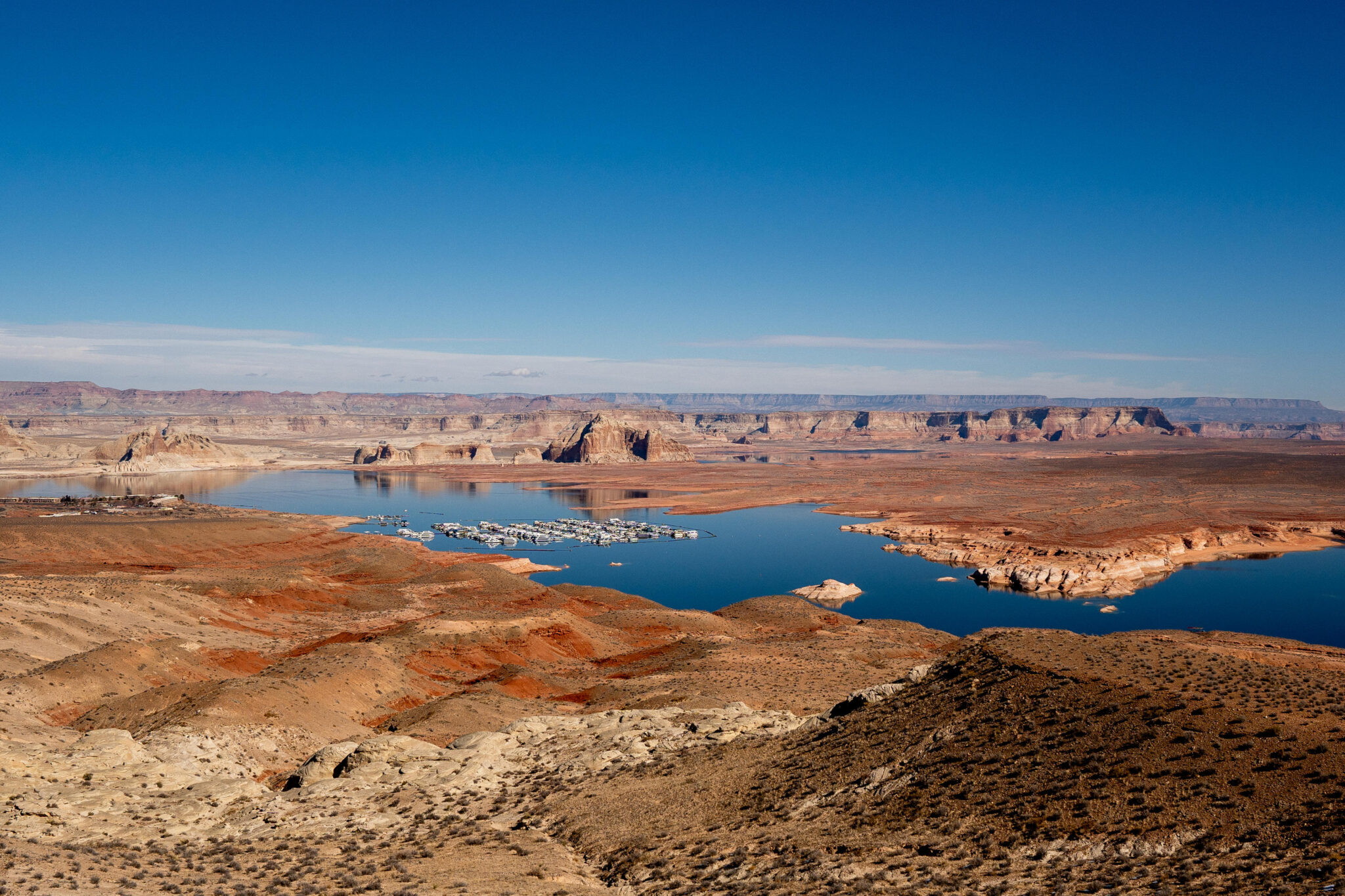
Lake Powell and Wahweap Marina back in August 2021, when the surface level was at about 3,549 feet. It’s now at 3,522 feet, just above the all-time low reached in April 2022. Jonathan P. Thompson photo.
The feds stepped in after the seven Colorado River states failed to agree on a new plan to replace the 2007 Interim Guidelines and the 2019 Drought Contingency Plans, both of which expire at the end of September. The states will continue to negotiate, and a seven-state consensus deal would take precedence over the federal plan.
Udall/Overpeck 4-panel Figure Colorado River temperature/precipitation/natural flows with trend. Lake Mead and Lake Powell storage. Updated through Water Year 2025. Note the tiny points on the annual data so that you can flyspeck the individual years. Credit: Brad Udall
Those plans were aimed at bringing overall demand back into balance with supply, which is not easy given that a warmer and drier climate is continually diminishing the already over-allocated river. While the document appears to have been completely scrubbed of any references to “climate change” or “global warming,” it does obliquely acknowledge that the cause of the current woes is a heating planet with passages like this one: “Imbalance between water supply and demand will be exacerbated by increasingly likely low-runoff conditions: The Basin is experiencing increased aridity due to climate variability, and long-term drought and low-runoff conditions are expected in the future.”
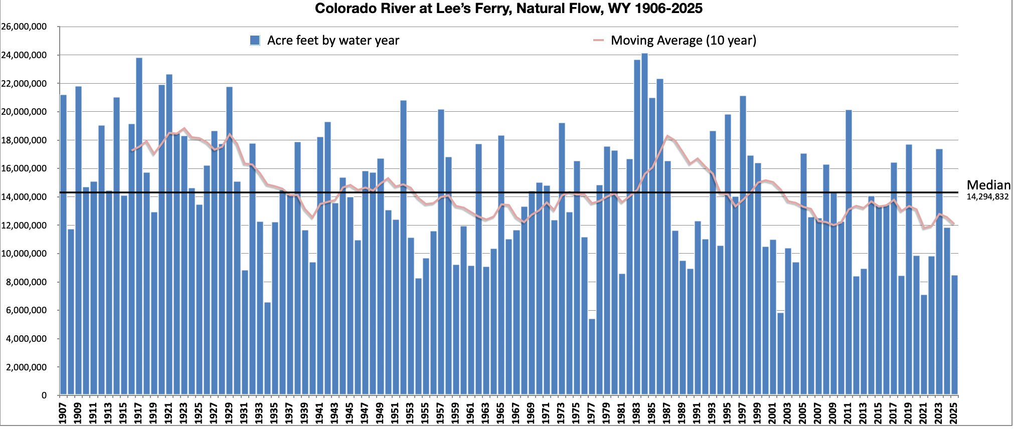
The natural flow flow at Lees Ferry, which is a calculation of what the Colorado River’s flow would be without any upstream dams, diversions, or human consumption. Land Desk graph using Bureau of Reclamation data.
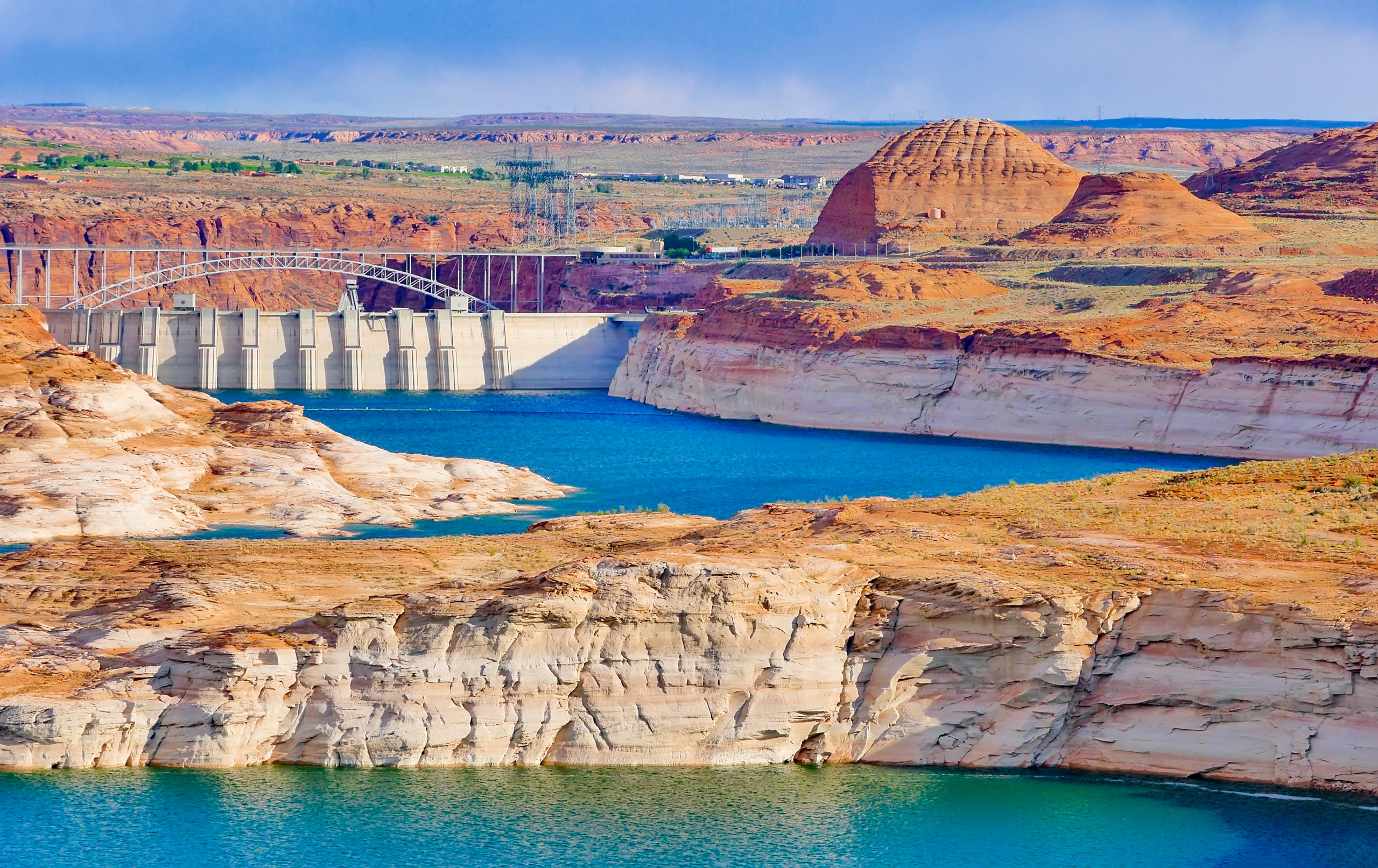
While the supply-demand balance is the central objective, a secondary one is to “protect critical elevations” at Lake Powell, which is to say they will take significant measures to keep the surface level from dropping below 3,500 feet, which provides a 10-foot buffer above minimum power pool. This not only preserves hydropower output, but it also avoids relying on the river outlet works for sustained releases. Meanwhile, the feds didn’t even consider proposals to drain Lake Powell or to build bypass tunnels around Glen Canyon Dam to allow for low-level water releases. [ed. Note that the USBR EIS is constrained by the “Law of the River”, the suite of agreements and legislation that details what the agency can do to operate the river.]
I should be posting articles here about the huge news Friday. But it wasn’t huge, it was boring and predictable. So is all the coverage. So are most of the people, the same people who get quoted over and over and over. Nothing but conventional wisdom, no ideas. Not a quotable… pic.twitter.com/A00bYHYhJH
Sorry, Ed. I’d like to help, but there’s not a whole lot of interesting things to say about this!
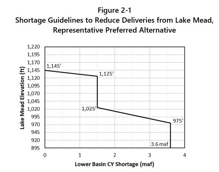
The release was met with much pomp and circumstance, along with a lot of hand-wringing and teeth-gnashing, though it didn’t contain any major surprises or changes from the draft EIS released earlier this year. The big takeaway, or at least the most talked-about one, is that the Upper Basin states will not be subjected to mandatory water use cuts, though they are being asked to cut about 200,000 acre-feet annually on a voluntary basis. The Lower Basin states, meanwhile, will be required to cut their consumption, perhaps by as much as 3.6 million acre-feet per year, depending on reservoir levels. That’s nearly half of those states’ Colorado River Compact allotment.
The cuts would be distributed based on water right priority, which would hit Arizona the hardest. That’s not because Arizona’s rights are junior to everyone else’s, but because their biggest straw — the Central Arizona Project — has junior rights, which the state accepted in exchange for federal funds to help build the thing and to help power its energy-sucking pumps.
Lower Basin leaders are, generally, livid. Arizona Gov. Katie Hobbs said the feds’ plan “still contains unacceptable options that include the federal government forcing Arizona to take the majority of draconian water cutbacks.” Nevada Gov. Joe Lombardo said the plan “seeks to impose unrealistic reductions on Nevada and our water users … {that} could have devastating economic and environmental impacts … .”
The response from the Upper Basin has been a more measured and mixed, but is predominantly one of relief at being spared mandatory cuts. But any celebration is tempered by the fact that nature is forcing its own cuts in the Upper Basin; irrigation canals are shutting down all over the place, long before the growing season is over, and some irrigators have received only a fraction of their usual allotment this year. Plus, the plan leaves open the possibility of draining Upper Basin reservoirs such as Flaming Gorge, Blue Mesa, and Navajo to buoy levels at Lake Powell. That will affect recreation and leave less water for irrigators and other users in the Upper Basin.
Meanwhile, advocacy groups are generally unhappy about the plan’s short-term approach, its focus on saving dams rather than the river, its willful ignorance of climate science, and its failure to force cuts on all river users. Even more dismaying is the fact that it doesn’t even cap Upper Basin consumption at current levels, implicitly allowing new diversions and water projects that would throw supply and demand further out of balance. “The Colorado River needs consequential and systemic change that confronts the ecological, political, and legal chaos caused by climate change and Glen Canyon Dam, but Reclamation’s plan is just ‘lather, rinse, repeat’ of past failed policies,” said Gary Wockner, of Save The Colorado, in a written statement.
This sentiment reveals a sort of paradox on the Colorado River: All of the water that flows to the Lower Basin and the industrial-scale alfalfa farms in the Imperial Valley also runs through the Grand Canyon, keeping that ecosystem healthier. Meanwhile, any water that the Upper Basin consumes or that is held back in Lake Powell to protect the dam’s integrity is water that doesn’t flow through the canyon.
There’s no indication that the Trump administration is punishing the Lower Basin states, however. It’s far simpler logistically to distribute and enforce mandatory consumption cuts in the Lower Basin because there are fewer diversion points, each of which is far larger than in the Upper Basin. Also, the 1928 Boulder Canyon Project Act made the Interior Secretary the “water master” on the Lower Colorado River, giving the feds greater authority to order shortages.
One question that remains unanswered is how reduced releases from Glen Canyon Dam would play out in the context of the Colorado River Compact, which dictates that the Upper Basin “not cause the flow of the river at Lee Ferry to be depleted below an aggregate of 75 million acre-feet” for any 10-year period. There’s a high likelihood that the 10-year aggregate flow will drop below 75 maf in the next year, giving Arizona possible grounds to sue and putting the interpretation of the clause into the hands of the Supreme Court.
Here are a few more details from the final EIS:
Glen Canyon Dam annual releases, which will be determined on Oct. 1, will range from 6 maf to 12 maf. This could drop as low as 5 maf if necessary to defend the “de facto deadpool” Lake Powell surface level of 3,500 feet. That would reduce flows in the Grand Canyon to below 7,000 cubic feet per second, and cause Lake Mead to drop further.
The maximum shortages/cuts for the Lower Basin would be 3.6 maf distributed as such:
Arizona: 1.96 maf
California: .9 maf
Nevada .21 maf
Estimated shortage impacts by water user type under various shortage conditions:
Acreage range of Indian Trust lands in the Lower Basin that would be fallowed under various shortage conditions:
AZ: 6,535 to 67,375 CA: 0 NV: 0
An alarming quote about how junior water rights holders are going to face shortages no matter what: Under the preferred alternative, “… for all Arizona, California, and Nevada junior entitlements (AZ CAP NIA-A and NIA-B; AZ CAP Indian, M&I, and 4(I); CA P4; and NV P8 priority groups) there are no potential futures in which >80% of normal domestic water delivery occurs.”
Lower Basin Tribal water users with present perfected rights would receive at least 80% of normal water deliveries in at least 90% of years across 2027-2039.
Glen Canyon Institute Executive Director Eric Balken observing the Cathedral. Photo credit: Glen Canyon Institute
During 75% of years under preferred alternative, Lake Powell’s level would be below 3,550 feet during at least 90% of months, meaning Cathedral in the Desert would be visible and accessible.
The EIS’s authors summed up the challenges with all of this — and the perils that may lie ahead — in one paragraph, writing:
Last winter’s meager snowpack near Silverton, Colorado, on March 14, 2026. Researchers analyzed Western snowpack data from the next day, March 15, to assess the influence of climate change on the historic snow drought and to project how future warming could affect the likelihood of similar events. Photo: Mitch Tobin/The Water Desk.
The American West’s historic snow drought in 2026 depressed skiers, heightened wildfire risks and constrained already scarce water supplies.
Was this extreme event just a stroke of bad luck in a region where snowfall naturally varies from year to year?
Or did the record-low snowpack bear the fingerprints of climate change?
A new study in the Proceedings of the National Academy of Sciences concludes that global warming more than quadrupled the odds of the West’s snow drought when compared to the preindustrial climate, before human greenhouse gas emissions began heating the planet.
In the Upper Colorado River Basin, where snowmelt supplies most of the water in a river that serves tens of millions of people and irrigates millions of acres of farmland, climate change’s estimated influence was even greater. Researchers concluded the snow drought was about 14 times more likely, although that estimate is more uncertain because the event was so exceptionally rare, even in today’s warmer world.
Looking ahead, scientists project that snow deficits as extreme as the West’s 2026 drought could become the norm by the end of the century if emissions continue to climb.
In the 2020s, a Westwide snow drought as bad as last season’s has about a 1-in-10 chance of occurring each year, so it’s still not the new normal. But the odds rise dramatically under the “moderately high” emissions scenario used in the study: the annual probability more than triples to about 1-in-3 by the 2050s and soars to nearly 9-in-10 in the 2090s.
Hydrologist Adrienne Marshall. Source: Colorado School of Mines.
I spoke with the study’s lead author, Adrienne Marshall, a hydrologist and assistant professor at the Colorado School of Mines. Excerpts from our July 23 conversation are below, edited lightly for clarity and brevity.
“Where we are is serious,” Marshall said. But she emphasized that a West where profound snow droughts are routine is not a fait accompli, because future greenhouse gas emissions are not set in stone.
“These are not predictions of what will happen in the future,” Marshall said. “I think this type of work is most useful if it is motivational and not discouraging.”
How would you summarize the most important findings of the study?
I think our most important findings here are that we were able to look at the extent to which this last year’s unusually low snow conditions were attributable to human-caused climate change.
We found that across the Western U.S., the low snow conditions we saw were about four and a half times more likely because of climate change that we’ve experienced to date. That is equivalent to a water volume that’s about the size of Lake Mead. If we think about a rare event in a world without human-caused climate change and a rare event in the world we’re living in, the amount of snow we’re missing is about the size of Lake Mead.
In the Upper Colorado River Basin, the snow drought was more extreme, so we find a higher “risk ratio,” meaning an increased probability due to human-caused climate change.
Did these findings surprise you?
The thing that surprised me was the magnitude. I wasn’t surprised to see that these events seemed to be attributable to human-caused climate change. I was a little bit surprised to see numbers that were quite as big as they were.
The study says that climate change made the snow drought about 4.4 times more likely. Could you explain that further? What exactly does that mean?
To dig into what that “more likely” means, people might have heard before of things like a 100-year rainfall event or a 100-year flood event, where we can say we would expect an event like this one to have maybe a 1% chance of happening each year. That would be a 100-year event.
So we took that approach with unusually low snow conditions. We used some models that were run for the 1850 to 1900 period, so that’s our period without human-caused climate change. And we saw that, in that period, the snow conditions we had this year would’ve been about a 1-in-30-year event. Then when we use those same models for about a 20-year period encompassing the world we’re living in now, we see it’s about a 1-in-7 event. And then we divide those two numbers, so 30 divided by about seven, to get that approximately four and a half times more likely value.
Skiers at Purgatory Resort in southwest Colorado on February 8, 2026. Photo: Mitch Tobin/The Water Desk.
Why is climate change making snow droughts like this much more likely?
In the most basic sense, there are two things that can cause snow drought. One is warm temperatures, and then the other one is just not getting any precipitation at all. So when we have warm temperatures, we get precip that falls as rain rather than snow.
When we think about the impacts of climate change, we have a lot of certainty about increasing temperatures. We have very good evidence that temperatures have increased, and models agree really well that they expect temperatures to continue to increase. That also aligns with our basic physical understanding of the Earth system.
Precipitation is a lot more uncertain, so it’s harder to see clear trends in winter precipitation so far, and models tend to disagree more about how we think precipitation will change—at least in the Western U.S. So when we think about the impacts on snow, those warming temperatures giving us less snow are kind of a really clear climate signal while the uncertainty in the precipitation can muddy the waters, relatively speaking.
With this snow drought, it sounds like it was really primarily driven by temperature.
We haven’t quantified what was the contribution of temperature versus precip. But if we look at what was happening across the West this year, temperatures were really unusually high over much of the winter, with sort of an extraordinary heat wave in March. Precipitation was low, but not extraordinary across most of the Southwest. And then as we look up into the Pacific Northwest and British Columbia, we tend to see precipitation that was a little bit above average up there. Temperature: kind of extraordinary. Precipitation: more within a range of variability that we’re used to seeing.
Source: National Integrated Drought Information System.
The date you used was March 15. We often hear about people using April 1 as the key milestone for snow water equivalent (a measure of the snowpack’s water content). Why did you use March 15?
We used March 15, in large part, because this year it looks like that was approximately peak snow water equivalent—when we sum up how much snow was sitting there across the West. We thought that was a useful indicator of how much snow does a water manager have to work with, even if it was earlier than usual. I think doing the same analysis with April 1 would be interesting, too. The statistics get a little bit more challenging for more rare events. Because of that March heat wave, I think that we would see that April 1 snow would likely have been even more extreme, which could make the statistics a little bit more challenging—increase uncertainty, essentially.
The study also looks specifically at the Upper Colorado River Basin. Could you explain what the findings were for that portion of the West?
In the Upper Colorado River Basin, this event was especially extreme. Snow was really particularly low. Our best estimate here is that, in the world we’re living in now, the snow conditions this year were about a 1-in-140-year event in the Upper Colorado River Basin, so quite rare. In the world without anthropogenic (human-caused) climate change, we think that it would’ve been maybe a 1-in-2,300-year event. Once we start estimating events quite that rare, we get big uncertainty ranges. Then when we divide those two, we see that in the Upper Colorado River Basin, we think that this event was about 14 times more likely because of human-caused climate change. But there our uncertainty is really large.
The Gold Mountain Fire burns near Ridgway, Colorado, on July 1, 2026. Photo: Mitch Tobin/The Water Desk.
The study also looks ahead to the future and the climate continuing to warm. What should we expect going forward?
These results were quite sobering. We look at what we would expect to happen in a moderately high greenhouse gas emissions scenario. What we see is for the Western U.S., we estimate that an event this bad had about a 10% chance of occurring each year in the 2020s. By the time we get to the 2050s, that slightly more than triples. So every year we would have about a 30% chance of having snow at least this low. And then by the 2090s, that becomes 87% of years, so we would expect that most of the time the snow would be at least this low Western U.S.-wide. In the Upper Colorado River Basin, we also see increases, but because this event was so extreme, we never see it becoming the norm in the 21st century.
The really important caveat here is that these are not predictions of what will happen in the future. These are our estimates of what we would expect in a particular greenhouse gas emissions scenario. And there are other greenhouse gas emission scenarios that are better. We could emit fewer greenhouse gases than this and do better than what these projections suggest.
It seems like pretty clear evidence for the benefit of reducing emissions for the snowpack.
The analysis I’d like to do is to look at the other scenarios and say, “OK, how much better would it be?” We don’t quite have the data to make exactly that apples-to-apples comparison at the moment, but there’s ways to pursue that . . . Based on our understanding of this system, I would strongly expect that if we look at a lower-emissions scenario, we would not see those probabilities climb quite so high.
We often hear the question, “Is this the new norm or is this the new normal?” These data suggest that it’s not right now. Western U.S.-wide, it could be by end of century. So I do look at that and think, “Let’s try to avoid that.” [ed. emphasis mine]
Low water at Blue Mesa Reservoir, along Colorado’s Gunnison River, on July 1, 2026. Photo: Mitch Tobin/The Water Desk.
What do you hope the public and decision-makers take away from this study and the projections?
There’s three big takeaways I have in mind. One is that I hope it’s clarifying in terms of where we’re at right now in terms of the impacts of climate change. It’s relatively new that we can look at a specific snow year and say, “Here’s how much this was caused by anthropogenic climate change.”
The second impact is I hope it’s useful for adaptation so that individuals and utilities and water managers can look at this snow year and think seriously about what we might like to do to adapt to more snow years like this.
And then the third thing is to help motivate us to see if we can push emissions trajectories downwards and do what we can to avoid having more snow years like this to the extent possible.
To learn more about the opposite of snow droughts—known as snow deluges—see my 2024 Q&Awith Marshall about her research on California’s epic snowpack during the 2022-2023 winter.
This story was produced and distributed by The Water Desk at the University of Colorado Boulder’s Center for Environmental Journalism.
Upper Colorado River basins. (The border of Wyoming and Colorado is mislabeled.) (U.S. BOR)
Aurora Water doesn’t much care which two days in a week you water your lawn, amid this historic drought.
But if your irrigation system starts up on a third day in the same week, the water world equivalent of a Flock camera is watching. The “smart” meters on every Aurora property automatically sense a spike in water use, and alert Aurora Water to confirm the violation and send out a warning or fine.
With updates at 15-minute intervals, the meters also detect irrigation watering during hot daytime hours when that’s against the rules.
The water surveillance, which Aurora Water officials acknowledge many of their customers might not realize exists, is one key to Colorado’s third-largest city so far achieving its water-saving goals in a year with record-low snowpack and abysmal streamflows into mountain reservoirs. Aurora says its 400,000 residents are using 27% less lawn water than in 2025, and managed a 9% cut from combined indoor and outdoor use.
Maintaining or even improving those savings is crucial as Aurora Water’s reservoir system sits at 49% full at a time when it should be above 80%.
Denver Water, meanwhile, has seen only about a 5% cut of water use compared with its previous five-year average among 1.5 million city and suburban customers. When Denver Water enacted twice-a-week watering restrictions in the spring, it set a target of a 20% cut from five-year average use.
Denver’s customers are doing better when using Aurora’s comparison with 2025 only, Denver officials said.
“Versus 2025, total water use is currently down about 7% and outdoor use is down about 16%,” said Travis Thompson, Denver Water communications manager.
The state’s largest water agency says it is encouraged by other statistics showing customers are using 21% less lawn water than they would have expected in the run of 95- to 100-degree days the Front Range experienced in July. In a summer that sits in the top 1% hottest and driest on record, the agency says, that’s a laudable savings mark.
One difference: Aurora Water spent millions of dollars in capital getting smart meters on every customer tap, while Denver Water chose to spend more of its capital speeding up replacement of aging, dangerous lead water delivery lines. Denver’s enforcement of drought restrictions to date has relied on thousands of neighbor complaints about properties watering more than twice a week, during restricted daytime hours or other violations.
“We have a far bigger tool than they have for being able to detect when people are using water irrigation water when they’re not supposed to,” said Shonnie Cline, Aurora Water’s deputy director of water internal and external relations.
Watchdog groups such as the American Civil Liberties Union in the past have raised questions about privacy invasions from smart home devices, including electric and water meters monitored by utilities. Especially by combining information from multiple meters, hackers or other bad actors could watch patterns and learn when people are home or away, are cooking, taking showers or other personal habits.
Cline said a better analogy than a controversial Flock camera is to see a smart water meter as a personal fitness tracker. “It gives you data and you are able to identify patterns that can improve your overall health if you make changes,” Cline said.
Aurora points out the smart meters for every customer work both ways, as a protection from leaks and potential property damage. Customers are able to log on and track their own use at the same time the city sees it, and could recognize a home leak while away on vacation, for example. During droughts, the meters will be one key to helping maintain reservoir storage for the benefit of the whole community, Cline said.
“There is a definite footprint that goes along with the data that indicates irrigation is taking place,” Cline said. “We have that pretty locked in where we can see when somebody’s irrigating, and so that’s why it’s interesting, because even when we send a warning, people are like, ‘But I didn’t!’ And then we’ll show them the data, and they’re like, ‘OK, I can’t argue with you, right?’ “
Denver Water, while enjoying higher water storage rates at its mountain reservoirs that have seen better snowpack, is not satisfied with customer savings rates and is now shifting somewhat from “education” to “enforcement” mode.
Denver had sent out nearly 3,600 warning letters but only five fines by the beginning of August. Fines will ramp up now that customers know what the rules are and Denver Water knows more about where the problem customers are, officials said.
Aurora Water, by contrast, has issued 234 fines after sending out more than 2,500 warning letters, including 10 of the highest $2,000 fines to businesses and large irrigation consumers. Only three customers were issued a second fine at the $250 residential level, Aurora Water said, and none had been issued a third fine. Aurora’s fines total more than $70,000.
Now that Denver Water has weeks of data on actual water use during drought restrictions, the agency can focus its communications on suburban areas with bigger lawns that haven’t cut back, said Greg Fisher, the utility’s manager of demand planning. Some of those suburban customers have no idea it’s Denver Water that collects their mountain runoff and delivers it to their local water utilities.
With only 5,000 advanced meters installed for 250,000 taps, Fisher said, word of mouth enforcement confirmed by onsite visits from Denver Water employees will continue to be the standard for warnings and fines.
“We continue to rely on, and I think it’s a pretty inventive idea, of letting our customers report water waste violations,” he said. “Even with the water people out on the street, we can’t be everywhere. So giving our customers the ability to report has been pretty powerful and I think effective for us.”
Denver Water officials do not anticipate asking their board this season to approve the next drought stage that would take lawn watering down to one day a week and add other restrictions. Denver Water would have to change its rate structure again to charge more for lawn watering that does occur to make up for loss of revenue from restrictions.
Plus, the utility thinks it’s a longer-term challenge to convince customers to change habits and stay “on board” with drought restrictions in the middle of what could be a multiyear crisis, Fisher said.
“We have a long game,” Fisher said. “This thing’s going to last a minimum of 12 more months, in my opinion, save for some sort of record-breaking snowfall this winter. So we’re in it for the long haul. I think we need to continue to up the message as we see conditions change. But at the same time, we really need to support our customers and have them stick with us for that extended period.”
People are capable of change, Denver Water officials said. The last drought this severe for Front Range customers was 2002.
“Our customers are using 100 million gallons less per day this year than they did in 2002, which is just stunning,” Fisher said. “And that translates to being actually 14% higher in our reservoir storage now than we were in 2002, because of our customers’ efficiency efforts over the last quarter century. We’re feeling really good about that. And that’s with significantly more population … 200 to 250,000 more people.”
Every so often it just seems like a good idea to drop out of the wrangling over the future of water in the arid west and – just go down to the river itself. A good friend abetted this by taking me along on a float down the lower Gorge of the Gunnison River. My friend was fishing; I was just along for the ride, and reflecting on my 60th anniversary of first moving to the Gunnison River valleys and the Colorado River Basin in 1966.
The Gunnison Gorge is a Bureau of Land Management Wilderness Area just downstream from the Black Canyon of the Gunnison River National Park. In 1966 I was – typically for a posturban American – unaware of where in the world I was, and didn’t know that the Gunnison River is one of the larger tributaries of the Colorado River, meeting the river in Grand Junction, Colorado, with a median contribution there of around 1.5 million acre-feet of water, with around another million acre-feet consumed by users in the Gunnison Basin, mostly for agriculture. This year, the river carries a fraction of that, less than a fourth of what passed for ‘normal’ through the 20thcentury.
Like most upper Colorado River tributaries, the Gunnison River alternates for most of its course between settled green mountain floodplain valleys, and canyons through which highways or railways might connect the valleys but otherwise humankind remains a visitor. The Gunnison’s Black Canyon is one of the steepest, deepest and narrowest canyons in the world, through which no highways or railways pass, and only a handful of adventurers float and swim through just to prove they can.
But the terrain levels out a little in the 14 miles of the Gunnison Gorge, creating long stretches of relatively broad slow-flowing stream, interrupted by rapids where side streams plunge in or rock falls have happened, creating a haven for fish and a gold-medal mecca for fishermen. Much of the Gorge is as narrow as the upstream canyon; dark rock walls on both sides rise steeply several hundred feet through most of it, with sand bars here and there for overnight camps and lunch stops. And everywhere in and along the river there are random rocks, ranging in size from a medicine ball to a small house; looking up the walls, one sees that more are awaiting some signal nudge to break off and fall, making one wonder what kind of mini-tsunami effect would happen if a raft were going by when a big one fell….
This is all what we call beautiful (recording it on our phones), but there is something else in these Gunnison canyons that goes beyond the pastoral scenic. You can get some of it in Connie Rudd’s sunrise image of the Black Canyon above. (Connie Rudd was superintendent of the Black Canyon National Park for a number of years.) The rock in the Black Canyon is not really black, but much of it is shadowed most of the time – not black so much as noir. The image shows the feature known as ‘The Painted Wall,’ due to its multicolored nature, but none of that is painted on; the river has exposed a cross-section of metamorphic rock that has been roiled, rolled, twisted, tilted, split and overturned, always under great pressure from earth layered on above and great heat from earth’s core hell. Rock that has had a hard life, not a comforting thought looking up at the walls from river level.
How did such a canyon system come to be? Gunnison Country geologist Tom Prather suggested that the Gunnison River, snowmelt from the already old Southern Rockies, had set its course looking as water does for the easiest routes through several hundred feet of fused volcanic ash from San Juan volcanoes to the south – on top of fused volcanic mud from the West Elk volcano to the north. And with its course already set in that stone, the forming river encountered the southern edge of a big blorp of metamorphic rock that was – well, just there. So rather than continuing to develop the open wide-V valley that most rivers are known for, the Gunnison River was captured by the hard rock with nothing to do but to cut an ever-deeper canyon that stayed steep and narrow with great hardrock walls in the Gunnison River’s Black Canyon and Gorge.
I am personally fascinated, in Rudd’s image, by how it shows the relative thickness of life as a layer contrasted with the geological layers. Look at the scrubby pinion-juniper and oak on the top of the Painted Wall. To call that layer of life on that mass of rock ‘skin-deep’ is almost an exaggeration. Our fossil-fueled efforts have expanded the layer of life to the seven miles or so above earth’s surface where we regularly fly, and the mile or so beneath the surface where we go to mine things we think we need, with nothing but microbial/incipient life above or below that. So life on earth occupies a layer 1/1,000th the diameter of the planet. If we remove fossil energy from the equation, the layer of earth and atmosphere occupied by life is probably measurable in thousands of feet rather than miles, less in total than a rounding error in the scale of the planet.
We’ve all heard the saying, ‘beauty is only skin-deep.’ But life is only skin-deep on the planet – ‘beauty’ is a term that works well in evaluations within that thin skin (as Connie Rudd’s image of the Painted Wall at sunrise is beautiful in its execution). But to be down in it, floating past rocks the size of small autos that came off those walls towering above – what’s there is some unarticulated and dynamic mystery beyond beauty. Maybe ‘awesome’ worked descriptively before that became a standard response to questions like ‘want to go for a beer?’ Maybe ‘Magnificent.’ ‘Stupendous.’ Or maybe just ‘brutal,’ if you’re floating along beneath it all; we don’t really get into its mystery until we’ve put it in terms in which we can feel something of the pain or ecstacy of what’s happened there.
Down in places like the Gorge that are beyond mere beauty and other ‘surface’ evaluations, I find my mind being stretched to the elastic limit over a concept like ‘nature.’ Or ‘god.’ The majority of us seem to be beyond a thoroughly churched ‘god’ (or panel of gods) as the creative force in the planet and its layer of life, but many of us seem to have just transferred to ‘nature’ that belief in some creative/destructive force larger than ourselves.
But it is not possible – for me, at any rate – to look up at these crumbling walls of tortured rock, some with trees struggling to grow in cracks in the rock until the roots split off the rock and tree and rock go in the river below with a wave that would smash a passing raft and its vacartioning passengers against the far wall – I can’t look at all of this and think of a loving ‘mother nature,’ a wisdom font of the sort we seem to want ‘nature’ to be, ultimately in charge of everything – that’s as hard as it is/was to look at ‘creation’ and imagine a ‘father god.’
Can we have creation without a designated creator – ‘god(s)’ or ‘nature’? All the ‘natural’ evidence I see points that way. In nature, life just happens, unfolds, evolves as it will or can: things just keep happening in what we call ‘nature,’ and when something happens, everything it happens to responds in some way – engages with it, absorbs or incorporates it, attacks it, tries to ignore it, sometimes succumbs to it, sometimes evicts it, and the whole incredible mishmash of life changing to adapt to things happening goes on. Sometimes what happens is something not happening, like a winter’s worth of snow not arriving, but it’s the same process: everything that this happens to responds in some way (some by also not happening)…. Life happens, and the living respond, and what happened (or didn’t) becomes part of life, in which things keep happening, on and on….
And to the extent to which old things happen in new places, to new groupings of living things with new responses and new outcomes, the process is creative, creation – sometimes creative destruction, but creation is not judgmental; creation just happens – as any mendicant poet or painter knows, trying to ‘look strange-eyed at the mindless world’ for the ‘dry sticks to turn to gold’ (thank you, Grendel).
That seems like the ‘nature of nature’ to me, and the nature of creation – and it has nothing to do with some set way that things are supposed to be. There’s no Garden of Eden/prelapsarian wilderness which we have destroyed or been ejected from; we still have all the indifferent wildness we can handle with the undomesticated Trumps, corporations and other weeds that grow out of the cracks of civilization’s pavement. American predatory capitalism is happening to the whole planet now, and everything on the planet, including its enshrouding atmosphere, is beginning to respond to that, seldom with appreciation.
Or so it seemed anyway, floating down the Gorge, in a protected wilderness park with nothing much to do but go with the flow and think about the life happening around me. One thing a water nerd like myself would of course think about, in thinking about the life happening around us, was the flow of the river that floated our raft. I knew the river was flowing at 300-350 cubic feet per second (cfs) through the Black Canyon and the Gorge; that flow was decreed as a year-round water right back in 2009 with priority to 1933 – along with an annual ‘spring flood’ flow for a short period usually in May, the volume depending on the depth of the mountain snowpack. Despite wilderness status for the Gorge and the ’natural’ appearance of everything there, the quantity of water flowing through is tightly controlled via releases from three dams upstream.
Aspinall Unit dams
A week or two after our float, the Bureau of Reclamation began cutting the flow to 200 cfs in response to the ‘creative destruction’ of the winter of 2026 that was happening. This reduction is happening mostly to protect the viability of the reservoirs from whence the water issues, but the river’s response to it will be to make some of the rapids in the Gorge more interesting (less water, more rock), and it may shut down the fishing (and some of the fish) as the remaining water warms to the point of endangering aquatic life.
We do have to face the fact that many, maybe most of our vaunted achievements as a civilization have not made life in the long run – even the medium run – better for ourselves and a lot of the rest of the planet’s life in a very basic way. And it seems to me we would probably do better at it if we could get away from the idea that some ‘god as a parent’ or ‘mother nature’ is going to show us The Way. The Way is still evolving, happening day by day, happening by happening. It’s truly dieu et la nature parmi nous, ‘god and nature among us’; someday maybe we’ll evolve enough to see that realizing either god or nature (making them real) is up to us, if we can come to collaborative execution as effective as our imagination. And we may do better there if we stopped looking and listening for god or nature as an already written book, and did more stopping, looking and listening for our own likely impacts before bulling ahead the way we usually do in the name of god or nature. Like it or not, we are probably writing the book, with a lot of the Old Testament chaos of false starts and backslides.
A line from a movie whose name I’ve forgotten came to my mind down in the Gunnison Gorge, a movie that ends (as I recall) in a lifeboat with the boat captain encouraging his rowers, ‘Pull for the horizon, boys; it’s better than nothing.’ A message of hope, as I remember, which should never be confused with optimism.
Okay – next post I’ll get back to the larger river and its challenges. Meanwhile, I hope all of you get some time to just irresponsibly drift this summer, like me in the Gunnison Gorge, and think about how life happens, and maybe some better responses we might all try to learn, better together.
ANOTHER SHAMELESS ADVERTISEMENT FOR MY POETRY BOOK
I am not optimistic
that things will get better
but still I hope
they will
hope
damned hope
hope damned
hope
the daisy game
is my game
petals to
the mettle
I can’t
not hope
An address by email to george@gard-sibley.org will get payment information and a book winging – okay, plodding its way to you.
Valley cities have spent years preparing for Colorado River shortages and say they are prepared to keep water flowing even under major federal cutbacks. Photo credit: Ted Wood/The Water Desk
Click the link to read the article on the KJZZ website (Alex Hager):
August 4, 2026
Colorado River shortages are no surprise. Climate change and drought have been steadily cutting into water supplies for about 26 years. Various plans to rein in demand have emerged throughout that time, and new cutbacks have been in the works for more than a year. The amount of water that each Valley city gets from the Colorado River varies significantly from city to city, but the majority receive at least some. Some cities are more prepared than others to weather today’s drier conditions, but most have at least some plan to deal with new Colorado River reductions. The Interior Department set the table for new cuts on Friday [July 31, 2026], laying out the framework of a plan that would allow the federal government to cut the Colorado River supply for Arizona, California and Nevada by up to 40%…A second announcement, which may come in the next few days, will deliver specifics about the size of cuts to the Phoenix area in 2027 and 2028.
Regardless of their scale, city leaders say they will be able to keep taps running.Like any good investor, most utility managers have focused on diversifying their portfolios. Essentially, the more different sources of water that flow to a city, the more it can tolerate cuts to one of those sources. In the Valley, that primarily means getting water from underground aquifers and the Salt River. Underground stores of water, pulled up by a system of wells, are carefully managed under state law and can give cities a backup in times of shortage on the surface. In some cases, water agencies have been taking excess water from the Colorado River for years and adding it to the underground stash, with the idea that it could be retrieved in times like these…In July, the Arizona Water Banking Authority announced that it will use its stored waterto make utilities whole in the event of cutbacks to their supplies from the Colorado River…Older, larger cities also tend to have more money for the kind of expensive engineering that can help diversify a water portfolio. For example, Phoenix is building a massive, high-tech water treatment plant that can safely recycle sewage back into purified drinking water. Major cities around the West are betting big on the technology to help withstand drought and climate change in the long term. Phoenix aims to send water from the $350 million facility into city pipes in early 2029. Cities that use water from the Salt River system are contributing to a multibillion-dollar expansion of Bartlett Dam, which holds back Bartlett Lake. In recent years, after particularly snowy winters, the river has provided more water than the reservoir can hold. A larger dam, cities say, would help them capture, store and use more water from the Salt River system in the future. For cities that lack diverse water portfolios and the kind of money needed for massive engineering projects, there’s a way for them to benefit from the cities that do. In April, as Colorado River cuts were becoming imminent, the city of Phoenix announced a new water transfer program called the “Secure Water Arizona Program”, or SWAP. Details are still emerging about how it would work, but it promises to connect cities that have water to cities that need water…Other water transfers, both in Arizona and across state lines, may be a big part of the long-term plan for cities and towns in the Valley. For example, farms may find it lucrative to sell some of their supplies to fast-growing cities in the metro that are willing to pay top dollar. Native American tribes, which often hold large, powerful legal rights to access the Colorado River, may also be willing to sell. A $5 billion settlement deal is currently in the works to give three Arizona tribes more access to their Colorado River water. If it passes, they could also gain the ability to lease their water to cities far from their reservations. Desalination, a high-tech process that can turn salty ocean water into pure, drinkable fresh water, has long been a tempting proposition for water-short cities. High costs and major logistical challenges mean that Arizona is unlikely to build its own desalination plant anytime soon, but a transfer program could allow it to benefit from an already-operational desalination facility. The Central Arizona Project and a handful of other water agencies around the region are exploring a deal to exchange water rights with a desalination facility in Carlsbad, California.
Moderate to heavy rain fell on almost all areas of dryness and drought along the Eastern Seaboard, improving conditions across large swaths of the region. Numerous locations experienced inundating rains and flooding, but drought conditions in some areas have been securely entrenched, limiting the amount of improvement introduced due to continuing impacts such as reduced water supplies, low groundwater, and similar hydrologic concerns.
Heavy to excessive rains also fell on some areas of dryness and drought farther west, from the central and northeastern Great Plains eastward through much of the Great Lakes Region and Lower Ohio Valley, prompting a few swaths of improvement there. But while heavy rains broadly affected the Eastern Seaboard and the Midwest, there were a few regions that missed the heavier amounts, leaving conditions essentially unchanged or even allowing for some deterioration. Temperatures averaging 6 to locally 12 deg F above normal in parts of the Upper Mississippi Valley and Great Plains, along with unusually low relative humidity across much of the Dakotas and Nebraska, accelerated surface moisture loss.
To the south, heavy rain was not as widespread across the Lower Mississippi Valley, the southern half of the Great Plains, and most of the High Plains. Still, moderate rains were not uncommon here, and there were isolated heavy amounts topping 2 inches. Thus, a variable pattern featuring areas of both deterioration and improvement was observed, with many locations essentially unchanged. Precipitation was markedly deficient from southern Kansas southward through much of Texas, resulting in broad areas of deterioration. Most of these areas were also warmer than normal, although humidity was not lacking. Much of the Texas Panhandle averaged 6 to 9 deg F above normal for the week. Other parts of this region were not as extreme, but most sites still averaged somewhat warmer than normal
From the Rockies westward, precipitation was sparse. Moderate amounts, with isolated totals over 2 inches, fell in association with the Southwest monsoon across portions of New Mexico and Arizona. Over the remainder of the West, scattered areas recorded several tenths of an inch to slightly over an inch across the Rockies and far Pacific Northwest, but most places recorded light precipitation at best. Very little rain fell across the Intermountain West, Great Basin, the interior Pacific Northwest, and California, although this is a dry time of year for many of those areas. Temperatures were above normal outside the Pacific Northwest
Dryness and heat intensified through most of Puerto Rico, with some areas recording one of the driest Julys on record. Hawaii and Alaska saw some new areas of abnormal dryness develop, along with moderate drought in extreme southeast Alaska…
Conditions varied significantly across the High Plains Region last week. Heavy rains of 2 to 5 inches with isolated higher amounts fell on northeastern South Dakota, a large part of northern and eastern Nebraska, and northeastern Kansas. Moderate to heavy amounts were observed elsewhere across the eastern and central sections of the Dakotas and Nebraska, southern and north-central and east-central Kansas, southeastern and the higher elevations farther west in Colorado, and patches of central and northern Wyoming and the western Dakotas. In the some of the drier parts of the region across North Dakota, central and western South Dakota, and western Nebraska, unusually hot weather accompanied the relatively low rainfall amounts. For the last 30 days, these locations generally averaged 4 to 8 deg F above normal, with a few spots in the western Dakotas and adjacent parts of Wyoming and Nebraska reporting 30-day average temperatures 8 to 10 deg F above normal. This included a few spells of extreme heat with high temperatures over 100 deg F. At the same time, relative humidity has been unusually low. Many areas across eastern Wyoming, western South Dakota, and adjacent Nebraska reported 4-week relative humidity averaging among the driest 10 percent of historic observations for the time period, and a few isolated spots were as dry as the lower 2 percent of historical observations. Less remarkable but still consistently below-normal relative humidity has prevailed over most of the region from the central Dakotas and Nebraska westward, along with most of Colorado. The dichotomy of conditions between eastern and western reaches of the Region is reflected in the changes introduced in the Drought Monitor this week. Most of North Dakota, the western half of South Dakota, and parts of northeastern Wyoming, western Nebraska, and northeastern Colorado saw conditions deteriorate, as did southern Kansas adjacent to Oklahoma. Meanwhile, eastern South Dakota, central through eastern Nebraska, southeastern Colorado, and western Wyoming notched sizeable areas of improvement. A new patch the worst drought classification (D4) was brought into northwestern Nebraska and another introduced in part of the Denver Metro Area. Existing areas of D4 remained intact in the Nebraska Panhandle, east-central Colorado, south-central and interior western Colorado. A majority of Wyoming and Colorado remain entrenched in D3, as do western reaches of Nebraska and South Dakota along with a few scattered locales farther south and east. In contrast, dryness has been entirely removed from sizeable parts of southeastern Nebraska, eastern Kansas, and the east-central Dakotas…
Colorado Drought Monitor one week change map ending August 4, 2026.
Areas of moderate to locally heavy rain, at least partially driven by a mature monsoon circulation, were observed across much of southern and eastern New Mexico, southeastern Arizona, the higher elevations of central Arizona, and a few scattered patches stretching from southern Utah northward through southeastern Idaho, southern Montana, and eastern Montana. A few swatches received similar amounts in western Washington. Other locations recorded little or no precipitation, although this is not uncommon during summer across much of California and the Far West. Conditions across southeastern Idaho and southern Montana have been exacerbated by temperatures averaging 6 to 10 deg F above normal during the past 30 days, including a few days of intense heat. Near- or below-normal temperatures during this period were restricted to the Pacific Northwest, central and northern California, and western Nevada. Relative humidity has been seasonably low during this period. The dry and hot conditions are not too out of character for July across California, Nevada, and southern Oregon, with drought designations unchanged from last week. Farther north, the lack of winter snowpack despite ample winter precipitation is starting to take its toll, with increasing moisture shortages leading to degradations across eastern Washington, northwestern and eastern Oregon, much of the Idaho Panhandle, and parts of eastern Montana. Meanwhile, locally heavy precipitation over the past few weeks, enhanced by rain from a mature monsoonal circulation, prompted localized areas of improvement in west-central New Mexico, parts of southeastern Arizona and some higher elevations farther north in the state, and a few places scattered across Utah…
Moderate to heavy rain was fairly widespread across central and eastern Tennessee and the eastern half of Mississippi, although amounts exceeding 2 inches were mostly limited to north-central and southeastern Tennessee. Light rain (several tenths of an inch) with scattered higher totals were observed farther west across Arkansas and, to a lesser extent, Louisiana. Farther west, there were a few swaths of moderate to heavy rain in parts of northwestern Texas, eastern Oklahoma, and central to southwestern Texas, but most of these two states reported no measurable rain to a few tenths at best. Recently, very hot weather has baked the northern portion of this region from the Red River Valley and the Texas Panhandle northward. Temperatures averaged 1-3 deg F above normal in northeastern Texas, 3 to 6 deg F above normal across most of Oklahoma, and 5 to 9 deg F above normal in the Texas Panhandle. Portions of Deep South Texas were also warmer than their typical mid-summer temperatures. The dryness and heat have accelerated deterioration across Oklahoma and northern Texas, where many locations are seeing dying grass, depleted stream-fed and farm ponds, and increased fire danger. The past 30 days brought less than half of normal rain to most locations from the Texas Panhandle and the Red River Valley northward, with the driest areas (less than one-quarter of normal) covering the central and eastern Texas Panhandle, western and northern Oklahoma, and some regions near the Red River. Subnormal humidity at the same time also aggravated the situation in the Texas Panhandle and western Oklahoma. As a result, drought degradation was widespread across most of Oklahoma and northern Texas, indicative of rapid surface moisture loss. Other areas of significant deterioration included western Texas, Deep South Texas, and western Arkansas. Abnormal dryness was also brought in to a few spots across Louisiana and Mississippi while more intensely dry conditions over portions of Arkansas and adjacent Mississippi were essentially unchanged. The past 30 days also brought less than half of normal rain to numerous locations across western and southern Texas, Arkansas, northern and eastern Louisiana, and central through southern Mississippi. Improvement was limited to portions of the wetter areas across eastern Tennessee…
Looking Ahead
During August 5-10, 2026, a decided lack of heavy rainfall is forecast across the Contiguous States. A few areas are expecting 1.5 to locally 3.0 inches of rain, but they are not extensive and include central Missouri, a few scattered patches along the Appalachians from western North Carolina to Upstate New York, isolated spots in southwestern Wisconsin and southwestern Michigan, and portions of central and west-central Florida. Totals of 1 to 2 inches are also possible in southeastern Arizona as well as some higher elevations in the state. Amounts exceeding an inch are also forecast across a large swath of Missouri and some adjacent areas, the southern Great Lakes and adjacent Mississippi Valley, most of western Pennsylvania, several areas in the Appalachians from northern Georgia through West Virginia, east-central Pennsylvania, portions of Upstate New York and adjacent Vermont, and the southern half of the Florida Peninsula. Scattered small patches across the central and eastern Gulf Coast, southeast and central Arizona, and northern New England may also record 1 to 1.5 inches. Other areas from the Mississippi Valley eastward are expecting light to moderate rain, with only a few tenths of an inch at best in much of the Lower Mississippi and Tennessee Valleys, southeastern Virginia, and adjacent North Carolina. Farther west, monsoonal moisture is expected to trigger light to locally moderate rains over parts of Arizona and New Mexico. Elsewhere from the central Great Plains westward, little or no precipitation is anticipated. Most of the country can expect near to above-normal temperatures during this period, especially over the Great Plains westward, where locations outside the Pacific Northwest and immediate West Coast are expected to record temperatures 5 to 11 deg. F above normal, with the greatest departures covering southern Kansas, the Texas and Oklahoma Panhandles, most of Colorado, and some adjacent areas. Temperatures east of the Mississippi River are expected to be closer to normal, although a few areas are expected to record somewhat warmer than normal conditions. Temperatures should average 4 to 6 deg F above normal across the Tennessee and adjacent Lower Mississippi Valley, across parts of the Mid-Atlantic Region, and northern New England.
The 6- to 10-day outlook (August 11-15, 2026) at least marginally favors above-normal precipitation from the Southwest, Great Basin, and Intermountain West eastward into the Great Plains. The best chances for significantly above-normal precipitation (over 50 percent) cover areas expected to be under the influence of the Southwest monsoon, from Arizona through most of Utah, eastern Nevada, and the southeastern California deserts. Odds lean toward above-normal precipitation in most of the eastern half of the country as well, excepting only the northwestern Great Lakes and adjacent Mississippi Valley, the southeastern Great Plains, the Gulf Coast and adjacent locales, and the lower Eastern Seaboard south of the Carolinas and central Georgia. Across the Contiguous States, enhanced chances for subnormal rainfall are limited to the Florida Peninsula. In Alaska, near normal precipitation is expected in central parts of the state and across most of Southeast Alaska, with subnormal amounts nominally favored in far southeastern areas that where moderate drought newly emerged this week. Above-normal precipitation is expected over most of Hawaii outside Kauai, with the best chances (over 40 percent) covering most of the Big Island. Meanwhile, warmer than typical mid-August conditions are favored across most of the Contiguous States, and throughout Alaska and Hawaii. Odds favor anomalous warmth from the Middle and South Atlantic Regions westward through the central and southern Great Plains, then from the entirety of the Rockies to the Pacific Coast. Chances for significantly above-normal temperatures are highest (near 80 percent) across the Big Island and southeastern Maui in Hawaii. The likelihood of above-normal temperatures exceeds 60 percent in a swath across central Alaska, in portions of the Lower Mississippi Valley and southern Great Plains, and the South Atlantic Region from most of Florida through eastern South Carolina.
US Drought Monitor one week change map ending August 4, 2026.
Just for grins here’s a slideshow of early August US Drought Monitor maps for the past few years.
A citizen-initiated lawsuit under the Clean Air Act forced a cleanup at ExxonMobil’s Baytown, Texas, refinery and chemical complex. AP Photo/Ashley Landis
Reducing rampant pollution across the United States was so important that when Congress passed many environmental protection laws, including the Clean Air Act, Clean Water Act and Safe Drinking Water Act, it didn’t want to leave enforcement only to the executive branch.
Congress specifically wrote into those laws ways for citizens to enforce them through the courts when the government does not act to address the problem. Called “citizen suit provisions,” those parts of the laws allow regular people and advocacy groups to sue companies they believe are violating the law. Citizens can also sue federal agencies that fail to enforce the laws.
Now, in a legal filing, the Trump administration is saying citizens should not be allowed to enforce environmental laws. Rather, despite what the laws say, the U.S. Department of Justice has claimed in a case involving Elon Musk’s xAI that people should be required to leave enforcement to the executive branch – even if the executive decides to take no action.
The Clairton Coke Works in Clairton, Penn., was forced to clean up its emissions and more effectively monitor pollution in a settlement of a citizen suit under the Clean Air Act. Rebecca Droke/AFP via Getty Images
A history of success
For more than 50 years, citizen suits have been an effective part of cleaning up the environment in the U.S. The process is fairly straightforward: A person or group must send a formal notification to the person, company or agency they suspect of violating the law – with a copy to the U.S. Environmental Protection Agency. If after 60 days the problem is not rectified, the people can sue.
Citizen suits often ask the courts to order a stop to the polluting activity, payments for reducing or cleaning up the harm done, and civil penalties paid to the government. But if the government has already begun an enforcement action or is actively prosecuting the violator, a citizen suit cannot proceed.
The success of these cases depends on the ability of the plaintiff to prove a violation of the law. Violations of the Clean Water Act are somewhat easier to prove than violations of other statutes because the simple act of discharging a pollutant without a permit is a violation of the law. As a result, more citizen suit provisions have been brought under the Clean Water Act than under any other environmental statute.
In my area of research, plastic pollution, citizen suits have been used to hold plastic pellet manufacturers responsible for pollution. For example, the citizen suit provision of the Clean Water Act allowed Diane Wilson, a shrimper from Texas’ Gulf Coast, to sue Formosa Plastics in 2017 for persistent discharges of plastic pellets into Lavaca Bay, where some shrimp were caught, and which is connected to the Gulf of Mexico. In 2019, Formosa ended up settling for $50 million to pay for mitigation and remediation projects in the bay, cleaning up plastic and other pollution. Formosa also agreed to pay court costs and attorneys fees.
In another example, the environmental advocacy groups PennEnvironment and Three Rivers Waterkeeper in 2023 sued Styropek USA, which manufactured expandable polystyrene used for packaging and shipping, over pellet discharges into a western Pennsylvania creek. The pellets attracted and collected other toxic chemicals and were harming local aquatic plants and fish. In 2025, Styropek settled for $2.5 million. As part of the settlement agreement, Styropek agreed to install filters in the facility’s wastewater and stormwater systems to capture plastic pellets before they reached Raccoon Creek or the Ohio River. Styropek also had to eliminate the unauthorized discharge of plastic pellets from all of the facility’s stormwater drains.
Citizen suit provisions are not included in every law. But they have arisen in other contexts. For instance, a 2025 Texas state law seeks to restrict abortion rights and allows any citizen to sue doctors or other medical providers who perform or assist with abortions.
Residents of Southaven, Miss., have publicly objected to the operation of gas-fired turbines to power a data center in their community. AP Photo/Adrian Sainz
NAACP v. xAI
In April 2026, using the citizen suit provision of the Clean Air Act, the NAACP, a nationwide civil rights organization, sued xAI, an artificial intelligence company founded by Elon Musk, in federal court.
The NAACP alleged that xAI and a subsidiary company built and operated 27 natural gas-fired turbines in Southaven, Mississippi, without the required Clean Air Act permits. The turbines generated electricity to power xAI’s nearby Colossus 2 data center. The NAACP alleged that the gas plant released harmful pollutants, such as nitrogen oxides and formaldehyde, which can increase rates of asthma, respiratory diseases, heart problems and certain cancers.
Had xAI applied for a permit to operate the turbines under the Clean Air Act, the EPA would have required xAI to use the best available technology to reduce those emissions. But xAI never applied to the EPA for a permit.
Artificial intelligence company xAI operates a data center powered by gas-fired turbines in Tennessee as well as one in Mississippi that’s the subject of an antipollution lawsuit. Brandon Dill for The Washington Post via Getty Images
A request from the federal government
In June 2026, the U.S. Department of Justice asked the judge to dismiss the case, claiming, among other arguments, that citizen suits cannot proceed when the federal government does not oppose the polluting behavior.
According to the Justice Department, the NAACP’s lawsuit threatens “artificial intelligence innovation” and national security. The government’s filing goes on to argue that citizen lawsuits were not intended to allow everyday citizens to enforce laws in ways that go against what the federal government deems is in the public interest.
Instead, the Justice Department claimed, citizen suits should be allowed by the court only when the government fails to enforce the statute, and not when the government has decided that executive branch policy means enforcement action is contrary to the public interest.
In the late 1990s, Robert F. Kennedy Jr. used citizen suit provisions to force environmental cleanups of industrial pollution in the Hudson River. AP Photo/Rick Bowmer
Conflict between the government and the public
This is the first time the Justice Department has taken this position in court. But defendants and judges have questioned the constitutionality of citizen suits in the past.
Regardless of how the court rules in the NAACP case against xAI, I believe the filing from the Trump administration is another step in a broader effort to consolidate government power in the executive branch.
Colorado could impose new fees on data centers and renewable energy companies, tax sod grass, or fund a special trust to raise the $20 billion it needs over the next 30 years to ensure it has enough water, as climate change saps streams and shrinks snowpack.
That’s according to a new report issued by a special task force created by Colorado lawmakers last year. Most of the measures the report examined would require action by lawmakers and potentially voters.
Until now, the state has relied largely on severance taxes collected on oil and gas, mining and coal production to help fund water projects, including shoring up old pipelines and dams, funding water-saving initiatives and buying new supplies.
But those severance tax revenues vary dramatically from year to year and are often diverted by lawmakers to help cope with budget shortfalls. That is a problem that needs to be solved, according to state Sen. Dylan Roberts, a Democrat from Frisco who co-sponsored the legislation creating the task force.
“This report makes clear that Colorado needs a long-term strategy for funding water infrastructure that doesn’t depend almost exclusively on the ups and downs of severance tax revenue,” Roberts said.
Task force members were charged with finding permanent, stable sources of funding that can’t be tapped for other purposes by lawmakers.
“If we could just maintain the funding we have, that would be a start,” said Jim Yahn, a water policy veteran and Logan County commissioner appointed to the task force by Gov. Jared Polis.
The report, produced by the Colorado Water Center at Colorado State University, said the state would likely need several mechanisms to generate the revenue needed, and it cited the success of a 2019 sports betting initiative approved by voters that has generated millions of dollars in tax revenues annually for water projects.
Still, it said, “The gap between the identified need and available funding is a current challenge visible in oversubscribed grant and loan programs, aging infrastructure, and the growing difficulty local governments face in accessing capital for large projects.”
The report cites programs by New Mexico and Wyoming that protect severance tax revenues by placing them in special trust funds that cannot be tapped for other purposes.
Karen Schlatter, director of the Colorado Water Center who led work on the report, said she is hopeful the findings will provide lawmakers with a set of options they can use in combination to stabilize water funding in the future.
Roberts said it was likely that lawmakers would work on new legislation next year to begin to address long-term funding solutions.
That’s something Yahn, who is the past manager of North Sterling and Prewitt reservoirs in northeastern Colorado, would like to see as well.
“A long time ago the state did something right by creating the revolving loan fund,” Yahn said, referring to a loan pool run by the Colorado Water Conservation Board that water districts can borrow from and whose loan interest payments help finance subsequent loans for other water districts.
“We got loans for our spillways and diversion structures and now we are paying it back in a steady stream that other people can use. But when you sweep it out, we don’t have it,” he said, referring to cash diversions by lawmakers. “The next step would be finding some legislators that would be willing to keep the money where it is. If we could get the ball rolling on that, that would be the next step I would like to see.”
At a meeting of water managers last month, the head of Colorado’s Division of Water Resources compared the state to Mordor — the barren, ash-covered domain of the villain in J.R.R. Tolkien’s “The Lord of the Rings” trilogy. He then flipped through a series of graphs showing streamflow gauges across the state. Each one was at or near record lows.
“The monsoons will help — they will help reduce demand — but they won’t bring storage back up,” state engineer Jason Ullmann told his fellow water officials. “I think we’re all holding our breath to get through this year.”
It’s too early to say that this summer’s drought is the worst on record, Ullmann said in a later interview. Heavy rains from the monsoon that arrived in July could alleviate the worst of the suffering — if those come. So far, rain has done little to lift the weight of drought. As it has for months, nearly the entire state is enduring some level of dryness, according to data released Thursday by the U.S. Drought Monitor. It considers half of the state to be in extreme or exceptional drought — the two most severe categories used by the agency. The latest Colorado map barely changed from the one released the week prior…
Colorado Drought Monitor map July 28, 2026.
Beyond the Front Range urban corridor, where many cities and utilities have imposed watering restrictions, the drought has caused millions of dollars in losses to Colorado’s farmers. It’s sapped reservoir storage and hamstrung river recreation — including rafting on many popular stretches of river. It has also spurred new collaborations between water users trying to survive.
Lake Powell and Glen Canyon Dam. Photo credit: Western Resource Advocates
Click the link to read the article on the Colorado Politics website (Marianne Goodland). Here’s an excerpt:
July 31, 2026
Calling it a balanced approach that offers flexibility and predictability, the plan released by the U.S. Department of the Interior cuts the allocation of Arizona, California and Nevada, while sparing Colorado, Utah, New Mexico and Wyoming for now…Under the plan, the Lower Basin states could face collective cuts up to 3 million acre-feet through 2036, “subject to hydrology,” according to a news release by the Department of the Interior. That’s enough water to serve more than 25 million people a year. The plan would also allow annual releases between 5 and 12 million acre-feet from Lake Powell, the basin’s second-largest reservoir. Under the 10-year federal framework, water management decisions will be made every two years…
Assistant Secretary for Water and Science Andrea Travnicek said in a statement Friday that the plan, known as a final environmental impact statement, “strikes a balance between flexibility and predictability for the Colorado River system that is vital to the 40 million people who rely on it, given unprecedented hydrologic conditions and the potential for considerable impacts on water users.”
Between 2020 and 2024, the average consumptive use in the Colorado River Basin was 13.1 million acre-feet. That is broken down by:
Upper Basin: 3.8 million acre-feet (29%)
Lower Basin: 6.5 million acre-feet (49%)
Mexico use: 1.4 million acre-feet (11%)
Evaporation: 1.4 million acre-feet (11%)
At the time the 1922 compact was signed, the seven states had a combined population of about six million — roughly the size of Colorado’s population today…
She said last month that she “has no idea what that process would look like, constantly negotiating every two years.”
“The basin is experiencing increased aridity due to climate variability, and long-term drought and low-runoff conditions are expected in the future,” wrote the Bureau of Reclamation in the summary. “These conditions will exacerbate the now widely recognized imbalance between water supply and demand in the basin. Robust and flexible guidelines are needed to manage the Colorado River system and its resources under a broad range of potential future hydrologic conditions.”
[…]
The two reservoirs are currently governed by guidelines established in 2007 that are set to expire this year, and many agree the plan has failed to protect the Colorado River system…The final proposal does not provide specifics for how water will be distributed across the basin, with the Bureau of Reclamation describing it as a “framework” that identifies key triggers and ranges for developing future operating guidelines at Lake Powell and Lake Mead. It sets up a plan to negotiate 2-year operating plans for the reservoirs through 2036…The final statement provides a range of alternatives, including the Bureau of Reclamation’s “preferred” option. Each alternative sets guidelines for how it will reduce or increase annual consumptive water use allocations from Lake Mead to the Lower Basin states; store and deliver water saved through conservation efforts; manage and deliver surplus water; manage activities and make cuts above Lake Powell; and more.
Map of the Colorado River drainage basin, created using USGS data. By Shannon1 Creative Commons Attribution-Share Alike 4.0
Click the link to read the article on the Pagosa Springs Sun website (Josh Pike and Randi Pierce). Here’s an excerpt:
July 29, 2026
Beginning July 22, area jurisdictions began rescinding Stage 2 fire restrictions, with Stage 1 restrictions remaining in effect in much of the area…On July 22, it was announced that improved fire weather conditions and near containment on the Ferris Fire had prompted Bureau of Land Management (BLM) officials to ease fire restrictions and reopen public lands within the Tres Rios Field Office. Effective July 22, Stage 2 fire restrictions were lifted on BLM-administered public lands managed by the Tres Rios Field Office, including Canyons of the Ancients National Monument…On Thursday, July 23, the Archuleta County Sheriff’s Office (ACSO) announced it had, in collaboration with the Pagosa Fire Protection District, rescinded Stage 2 fire restrictions effective immediately…The following day, Friday, July 24, the Town of Pagosa Springs announced it had rescinded Stage 2 fire restrictions effective that day…On Wednesday, July 29, the San Juan National Forest announced it would be rescinding Stage 2 fire restrictions effective 12:01 a.m. Thursday, July 30, on all National Forest System lands…
Colorado Drought Monitor map July 28, 2026.
According to the Community Collaborative Rain, Hail and Snow Network (CoCoRaHS), areas in Archuleta County received from .91 inches to 3.15 inches of rain between July 15 and July 29. Despite the recent rains, the Pagosa Area Water and Sanitation District (PAWSD) remains in stage two drought restrictions, and the area remains in severe drought. According to the U.S. Drought Monitor, 100 percent of Archuleta County remained in severe drought as of July 21, with 1.90 percent of the county — the northeast corner — falling under extreme drought. The week prior, 36.15 percent of the county fell under extreme drought…
According to the U.S. Geological Survey water monitoring gauge at the San Juan River in Pagosa Springs and the Colorado Basin River Forecast Center, although the San Juan has remained at a very low but generally steady level, it did appear to hit record low levels several times over the last week. According to the River Forecast Center, on July 24, the river hit about 19 cubic feet per second (cfs), below the 2002 low of 21. The following day, it hit about 17 cfs, below the 2002 low of 19 cfs. On July 28 at 11:15 a.m., the river was recorded running at 15 cubic feet per second (cfs), 0.5 cfs above the previous record low set in 2002.
Map of the San Juan River, a tributary of the Colorado River, in Arizona, Colorado, New Mexico and Utah, USA. Made using USGS National Map data. By Shannon1 – Own work, CC BY-SA 4.0, https://commons.wikimedia.org/w/index.php?curid=47456307
After Utah and six other states along the Colorado River failed to reach a deal on how to share its dwindling water supply, the federal government on Friday released its own 10-year outline.
Colorado River Collaborative
This article is published through the Colorado River Collaborative, a solutions journalism initiative supported by the Janet Quinney Lawson Institute for Land, Water, and Air at Utah State University. See all of our stories about how Utahns are impacted by the Colorado River atgreatsaltlakenews.org/coloradoriver
Under the proposal from the U.S. Bureau of Reclamation, the Lower Basin states of Arizona, California and Nevada would share in cuts of up to 3 million acre-feet per year. The framework doesn’t mandate cuts for Colorado, New Mexico, Utah and Wyoming.
Instead, it identifies a conservation goal for the Upper Basin — 200,000 acre-feet per year — about as much as Utah’s Deer Creek and East Canyon reservoirs together can hold. The plan would also allow for smaller annual releases from Lake Powell of down to 5 million acre-feet, compared to the current 6 million acre-feet, with new operating guidelines every two years.
Utah’s chief Colorado River negotiator, Gene Shawcroft, praised the proposal on Friday, telling reporters it recognizes the reality of the water available, not just the demand. But he emphasized it provides a broad framework, with the details to follow in coming days.
“I would just simply say, this is a bridge, not a destination,” Shawcroft said in a virtual news conference. “It certainly could be a bridge over troubled waters, but perhaps a bridge over no waters. We just aren’t quite sure.”
He and Amy Haas, executive director of the Colorado River Authority of Utah, were still reading through the 2,600 pages contained in the bureau’s environmental impact statement released Friday.
Haas said the state will know more about what it’s contending with when it gets a copy of a two-year operations plan for 2027 and 2028 in coming days, though the exact timeline wasn’t clear.
The Colorado River is pictured where if flows near Hite, just beyond the upper reaches of Lake Powell, on Friday, Sept. 19, 2025. (Photo by Spenser Heaps for Utah News Dispatch)
The Colorado River provides water to 40 million people across the U.S. and Mexico, contributing 27% of Utah’s water supply. It’s shrinking because of drought, overuse and hotter temperatures linked to climate change.
This year’s record-high temperatures and lowest snowpack on record aren’t helping. Normally, Colorado River runoff is about 13 million acre-feet, Shawcroft said. Now it’s 3.5 million acre-feet.
He told reporters: “We’re in a dire situation.”
On Friday, Arizona’s Department of Water Resources called the proposal’s cuts for the Lower Basin “unacceptable,” saying such reductions would devastate Arizona’s water users and its economy.”
The agency described negotiations over many months as “an exercise in lowering expectations, particularly for a long-term, seven-state agreement on operating this vital river system.”
The disagreement could find its way into a courtroom soon. Arizona and Utah have both taken steps this year to build up litigation funds.
“For Utah, litigation is never our plan A,” Haas told reporters Friday. “Whether it’s a plan B, depending on the context of this document, that remains to be seen. But litigation is not going to get us anywhere on this river. It’s not going to get us more water.”
At issue in the negotiations is who absorbs necessary cuts. Upper Basin states argue they use less water than Lower Basin states, don’t have huge reservoirs to store water in dry years, and lack legal authority to place significant restrictions on water users.
Lake Powell and the Wahweap Marina are pictured near Page, Arizona on Sunday, Feb. 2, 2025. (Photo by Spenser Heaps for Utah News Dispatch)
The proposal out Friday is adaptable and allows the states to keep negotiating, said Secretary of the Interior Doug Burgum.
“This framework provides the flexibility to respond to changing hydrologic conditions while preserving the opportunity for the Basin States to continue working toward durable, consensus-based solutions,” Burgum said in a statement.
Utah Gov. Spencer Cox, in a joint statement with his counterparts in the other upstream states, said they’re encouraged that incoming operating guidelines “will better reflect existing water supply, which must underpin any practicable plan going forward.”
They went on to say that both the upper and lower divisions of the basin “are feeling the pain of severe drought. This is a reality that all states, and the federal government, will need to address practically, which is why a seven-state agreement will provide the best outcome for all water users in the Colorado River Basin.”
Water use is outpacing the river’s flows, and that overconsumption adds up. The combined amount of water in Lake Powell and Lake Mead is at its lowest point since before Glen Canyon Dam began to fill up in 1963, the bureau said in its Friday news release.
If water levels dip to critical lows, as forecasts suggest they could by late this year, the nation’s two largest reservoirs could fail to produce power. If their depths continue to slide, they’ll fail to send water downstream.
Conservation and recreation groups have called for an end to the gridlock, saying it’s dragging on in the background while hotter and drier conditions are driving up wildfire risks, air quality concerns and restrictions on the water supply.
Utah News Dispatch is part of States Newsroom, a nonprofit news network supported by grants and a coalition of donors as a 501c(3) public charity. Utah News Dispatch maintains editorial independence. Contact Editor McKenzie Romero for questions: info@utahnewsdispatch.com.
The Colorado River Basin spans seven U.S. states and part of Mexico. Lake Powell, upstream from the Grand Canyon, and Lake Mead, near Las Vegas, are the two principal reservoirs in the Colorado River water-supply system. (Bureau of Reclamation)
The federal government on Friday formalized a set of guidelines for managing water use in the Colorado River Basin over the next decade, if Colorado and six other Western states can’t come to an agreement on how to deal with declining flows caused in large part by climate change.
“The Department has a responsibility to ensure the Colorado River system remains reliable and resilient for the millions of Americans, communities and industries that depend on it,” Interior Secretary Doug Burgum said in a press release. “This framework provides the flexibility to respond to changing hydrologic conditions while preserving the opportunity for the Basin States to continue working toward durable, consensus-based solutions.”
Under the U.S. Bureau of Reclamation’s “preferred alternative” for the management of the river’s reservoir system, outlined in a extensive environmental impact statement, the burden of the most severe cuts would continue to fall on the Lower Basin states of Arizona, California and Nevada, which could face mandatory cuts of up to 3 million acre-feet of water. The Upper Basin states of Colorado, New Mexico, Utah and Wyoming would face only voluntary conservation targets totaling 200,000 acre-feet.
All seven states were parties to the Colorado River Compact, a 1922 agreement governing the use of water from the vital Western watershed. Today, the Colorado River provides water to an area inhabited by 40 million people across the Southwest, though agricultural uses account for the vast majority of consumption.
Udall/Overpeck 4-panel Figure Colorado River temperature/precipitation/natural flows with trend. Lake Mead and Lake Powell storage. Updated through Water Year 2025. Note the tiny points on the annual data so that you can flyspeck the individual years. Credit: Brad Udall
Since 2000, a megadrought caused largely by global warming — the region’s worst dry spell in at least 1,200 years — has stressed water supplies across the basin and pushed the Colorado River Compact to a breaking point. The last set of federal guidelines to address shortages, issued nearly 20 years ago, will expire Jan. 1, and the seven Colorado River Compact states failed to reach a new agreement before a federally imposed deadline in February.
The combined amount of water stored in Lake Powell and Lake Mead, the Colorado River system’s two key reservoirs, fell this month to its lowest level since May 1957 — before Lake Powell, created by the Glen Canyon Dam, had even begun to fill.
Without a major turnaround in hydrologic conditions in the near future, water levels in Lake Powell are expected to fall by next spring to below “minimum power pool,” at which point the Glen Canyon Dam’s hydroelectric turbines would be unable to operate.
Negotiations over a comprehensive new agreement have led to an increasingly bitter dispute between the Upper Basin states — led by Colorado, the river’s headwaters state and by far the Upper Basin’s largest water user — and the Lower Basin states, especially Arizona, which has borne the brunt of the cuts imposed in recent years. Arizona is widely expected to launch a high-stakes legal challenge as soon as this summer, alleging Colorado and other Upper Basin states are failing to meet an obligation under the original Colorado River Compact to allow enough water to flow downstream.
Colorado Gov. Jared Polis issued a joint statement Friday with the governors of the other three Upper Basin states, saying that “both the Upper and Lower divisions of the basin are feeling the pain of severe drought,” and that they were “committed to continued good-faith discussions with our counterparts.”
“Many hours of meetings and negotiations took place between the Colorado River Basin states and these discussions will continue,” the statement said. “Today’s framework does not represent a final solution, but enables the River to be managed in the short-term while the seven states and (the Interior Department) continue to negotiate a consensus solution.”
In the absence of a new agreement among the states, the Bureau of Reclamation says it will continue to update its new guidelines every two years until 2036.
Andrea Travnicek, the Interior Department’s assistant secretary for water and science, said the plan “strikes a balance between flexibility and predictability … given unprecedented hydrologic conditions and the potential for considerable impacts on water users.”
In a statement, Democratic U.S. Sen. Michael Bennet of Colorado said he was “disappointed” by the failure to reach a new long-term agreement among the seven Colorado River Compact states.
“While a two-year operating plan is the bare minimum needed to operate the river, a long-term, consensus agreement that recognizes real hydrologic conditions is the only durable solution to bring certainty to the Colorado River,” Bennet said.
Colorado Newsline is part of States Newsroom, a nonprofit news network supported by grants and a coalition of donors as a 501c(3) public charity. Colorado Newsline maintains editorial independence. Contact Editor Quentin Young for questions: info@coloradonewsline.com.
Map of the Colorado River drainage basin, created using USGS data. By Shannon1 Creative Commons Attribution-Share Alike 4.0
Map of the Upper Colorado River Basin showing project reservoirs where new monitoring equipment is deployed. Note: Reservoir extents have been exaggerated for visualization. Credit: The Desert Research Institute
DRI and OpenET are partnering with the Upper Colorado River Commission and the Bureau of Reclamation to expand evaporation monitoring on the Upper Colorado River Basin’s largest reservoirs. This summer, new monitoring stations are being established on Flaming Gorge, Blue Mesa, and Navajo Reservoirs. The initiative follows the success of the Lake Powell evaporation monitoring project – one of the longest-running reservoir evaporation monitoring efforts in the Western U.S., which has provided data since 2019. Establishing state of the art weather and evaporation monitoring stations at these reservoirs will directly inform improvements for evaporation models and our understanding of water availability in the Colorado River.
DRI’s evaporation monitoring uses advanced micrometeorological stations that collect continuous observations of weather, water temperature, and calculated evaporation rates. The Reservoir Evaporation Research Team, led by DRI’s Justin Huntington and Chris Pearson, has led numerous open water evaporation data collection and modeling efforts in the Western U.S., including the Bureau of Reclamation’s Open Water Evaporation Network Initiative and a statewide effort to track daily reservoir evaporation rates throughout Texas.
“High-quality, over-water data provide critical benchmarks for validating and refining both satellite-based and gridded weather models, supporting more reliable large-scale evaporation estimates.”
By installing the weather stations on floating platforms directly on the water, DRI’s instrumentation obtains more accurate data than traditional methods that occur on land adjacent to reservoirs. The weather stations transmit measurements in near real-time to DRI portals that allow for the data to be visualized and monitored by researchers and water managers. Specialized equipment known as an eddy covariance station is used to calculate evaporation using high-frequency measurements of water vapor, wind speed and direction in all three spatial dimensions.
Below is the Precipitation Accumulation in South Platte graph from the NRCS for August 3, 2026. This morning precipitation is at 75% of the median (down 1% one week), and 66% of the water year median (up 1% one week). There are 58 days left in the water year.
There is a chance for showers today, a chance for Thunderstorms Tuesday, then a chance for showers and thunderstorms Sunday in the central mountains. There is a chance for thunderstorms today and Tuesday, with a slight chance for showers and thunderstorms Sunday in the northern mountains. There is a slight chance for thunderstorms today and Tuesday, down here, about 227 miles from the Battle of Milk Creek Park near Meeker. The location is the site of the Battle of Milk Creek where Ute Indians ambushed U.S. troops led by MajorThomas T. Thornburgh, 18 miles (29 km) north of present day Meeker, Colorado. From Wikipedia:
Major Thomas T. Thornburgh led a command of 153 soldiers, and twenty-five militiamen, to the White River Indian Agency from Fort Steele on September 21, 1879, in response to a request for assistance by the Nathan C. Meeker, U.S. Government Indian Agent…On September 29, 1879, Ute warriors simultaneously ambushed Thornburgh’s forces and, at the Indian Agency, killed Meeker and Meeker’s employees. Ute warriors, led by Chief Colorow, attacked Thornburgh’s forces at Milk Creek on the northern edge of the reservation, about 18 miles from the White River Indian Agency. Within a few minutes, Major Thornburgh and 13 men were killed, including all his officers above the rank of captain. Another 28 men were wounded. Three-quarters of the horses and mules were killed at leisure by the surrounding Utes…Surviving troops dug in behind the wagon trains and animals’ bodies for defense. One man rode hard to get out a request for reinforcements. The US forces held out for several days…The troops were reinforced by 35 African-American cavalrymen known as Buffalo Soldiers from the 9th Cavalry at Fort Lewis in southern Colorado…Larger U.S. Army relief columns were sent from two forts, Fort Steele and Fort D.A. Russell…ColonelWesley Merritt commanded five columns of troops from the 5th Cavalry Regiment, or about 350 troops, who traveled by train and marched to reach the surviving forces on Milk Creek on October 5. By the time Colonel Merritt arrived, the Utes had already dispersed.
Here’s a look at the 7-Day Colorado precipitation map through July 31, 2026 from the High Plains Regional Climate Center (latest map available from HPRCC this morning). Precipitation in the South Platte Basin along the Continental Divide of the Americas ranged from 0.30” to 1.80”.
Here’s the 7-Day percent of normal precipitation map through July 30, 2026 from the High Plains Regional Climate Center (latest map available from HPRCC this morning). Precipitation in the South Platte River Basin along the Continental Divide of the Americas ranged from 130% to 300% of normal.
Below is the 7-day Quantitative Precipitation Forecast for the week of August 3, 2026. Precipitation is anticipated for the mountains of the South Platte River Basin and may total up to 0.10″.
Below are the 8-14 day outlooks from the Climate Prediction Center, issued August 2, 2026, for temperature and precipitation, for the week starting August 10, 2026. The CPC expects above normal temperatures and above normal precipitation for the mountains of the South Platte River Basin.
Below is the Colorado Drought Monitor map from June 28, 2026. There was a small one class improvement in Elbert County. Drought and abnormal dryness covers 97.50% of Colorado. The South Platte Basin is experiencing Abnormally Dry, Moderate, Severe, Extreme, and Exceptional drought conditions.
Below is the Colorado Drought Monitor one week change map ending July 28, 2026.
Here’s the US Drought Monitor Map from last week along with the one week U.S. change map.
Finally, here’s a map showing the effect on temperature from fossil fuel combustion and methane venting for the 9-month period from October 2026 through June 2026.
Most of the West has just experienced the warmest nine-month period during the last 131 years, putting the region on pace to have its hottest water year on record.
A satellite image of the Phoenix metro area with the moisture index layer turned on (blue = more moisture; red = drier). Scroll down to see more images and explanations. Source: Copernicus Browser.
Click the link to read the article on The Land Desk website (Jonathan P. Thompson):
July 31, 2026
The Land Desk is evolving! During the five and a half years that I’ve been doing this, several readers and would-be-donors have urged me to make this little enterprise a non-profit. I often would respond with something like, Yeah, I’m already there. To which they’d say: No, become a 501(c)3 so that our donations can be tax deductible, dummy!
And so, finally, my wife Wendy and I bit the bullet, hired an accountant, and went through the red tape to get it done. And so, the IRS made it official earlier this month: The Land Desk Media is officially a 501(c)3. Don’t worry, we’re not going to be begging you for money every few months, or holding fund-drives, or whatever. The model will stay pretty much the same; this simply allows folks who have been so generously supporting the Land Desk as Founding/Sustaining Members, Buy Me Coffee donors, or tip Jar tippers to write off those donations.
We’ll still have free subscriptions and paid subscriptions, with the same benefits for both (the $60/year and $6/month subscription fees do not count as tax deductible donations, but if you sign up as a Sustaining Member for $200/year, for example, $140 of it would be deductible). We may occasionally look to raise money for specific initiatives: to hire a freelancer, to offset travel costs for a reporting trip, to buy a new camera lens or whatnot, to expand the scope of the Land Desk’s coverage, or to publish a book or two under our imprint, Lost Souls Press.
We’re still lining up our ducks with some of the details, but if you’d like to donate, you can do it here: Make a tax deductible donation
The Land Desk News Feed
As long as we’re talking shop, the Land Desk is about to go through a different sort of evolution, this time by adding an appendage, if you will: a human-curated rundown of the week’s biggest news from the Land Desk realm, which would include public lands, energy development, wildlife, economics, water, climate, water, and more. It would be a list of a dozen or so summaries of the news items, along with a link to the original story or stories.
This will be a once-a-week dispatch (in addition to the two each week that I send out now). The idea is to allow readers to stay in the loop without some big commitment to read a bunch of context, and for me to update folks on developments in ongoing stories in a concise way while also amplifying other voices and journalism from around the region.
I do this sort of thing three times a week for Canary Media in which I gather and summarize Western energy stories. Here’s an outtake from a recent edition:
But the Canary gig is coming to an end, which is giving me the push I needed to implement this sort of thing (although with a much broader subject range) here at the Land Desk.
I think a lot of readers will value this service, but at the same time, I don’t want to overwhelm your email boxes with too many dispatches every week. So I’m hoping y’all can let me know whether I should add this as a third weekly email for all paid and free subscribers? Or should I make it a separate newsletter altogether that would require signing up separately? (Click through to the article to participate in Jonathan’s poll.)
⛈️ Wacky Weather Watch⚡️
When I was a kid, my family occasionally took trips to Phoenix, usually to visit my grandparents who wintered in a single-wide in Apache Junction due to my grandfather’s emphysema. I loved everything about these journeys: peering out the car window as we floated through the Navajo Nation, dropping from one season into another as we descended the Mogollan Rim, competing with my brother to spot the first saguaro, and ending up in a place where palm trees lined streets and citrus orchards surrounded the city.
In my teens and twenties my fondness for the Sonoran Desert migrated southward to Tucson. I was drawn by the vibrance of both the city and surrounding desert, as well as the climate; in the springtime I could begin a hike up Mt. Wrightson in t-shirt and shorts, strolling below the lush canopy amid birdsong, and end up huddling under a rock in a blizzard at the top. Then I could reward myself with some killer tacos in South Tucson on the way back. I always figured I’d live down there someday.
I’m still fond of Tucson and, yes, even Phoenix. But the idea of living in the place, especially the latter, gets less and less palatable with every passing year as temperatures rise. Check out this weekend’s forecast, which, believe it or not, is actually milder than the high temps from last weekend:
The 115° F daytime high is brutal — especially for those with homes that don’t have AC or decent insulation or who don’t have houses, at all. That’s the kind of heat that kills, as the statistics make all too clear. But it’s the 93° F nighttime low that really frightens me: The city is still an oven during the coolest, darkest hours of pre-dawn. Even if you do have a climate-controlled home and good AC in your car, you’re virtually trapped inside. A 5 a.m. run in those temperatures would be unhealthy, maybe even deadly.
But don’t think you can escape by heading to Colorado or Utah. Grand Junction and Hotchkiss are sweltering through triple digit highs as well; Moab’s mercury may hit 110° F this weekend, with 112° F forecasted for St. George. The timing’s especially bad for farmers in the North Fork Valley, where one of the major irrigation canals is shutting down today (July 31) due to lack of water in the reservoir (at least one of the other big ditches in the area shut down on July 20).
The current heatwave comes on the heels of an extreme heat spell that shattered all-time maximum heat records at 88 weather stations across the West, e.g.: 114° F in Brandenberg, Mont.; 104° F in Swan Valley, Idaho; 104° F at Pineview Dam, Utah; 109° F in Thermopolis, Wyo.; and 113° F in Burlington, Colo.
Those extraordinarily warm temperatures joined up with lightning to spark fires across the region, especially in the Northwest, which continues to burn. Oregon’s Lowe Creek Complex has ballooned to 300,000+ acres, and several other fires in the region exceed 50,000 acres in size. The smoke is traveling across the country and is even dimming air quality on the East Coast. More fire weather (dry, hot, windy) is forecasted for this weekend.
And if the heat doesn’t get you, the flash floods could. The intense yet isolated thunderstorms continue to wreak mayhem. Two massive debris flows hit Hwy 550 between Ouray and Silverton on Wednesday, trapping motorists and shutting down the artery — it remained closed Thursday night. Flooding also occurred on the Gold Mountain Fire scar north of Ouray. On Wednesday, the normally tame Cutler Creek became a raging, chocolate-colored, fire-debris-filled torrent that escaped its banks and blasted into homes, causing one family to fear for their lives.
In the winter, Colorado staffs mountain highways with avalanche forecasters to monitor conditions and recommend shutting down the roads during high danger. With all of the landslide/debris flow action affecting highways and backroads, perhaps it’s time to make the program year round?
Thankfully, the rains have helped stifle the erratic behavior of the big blazes in Colorado and Utah, though a new fire, the Rio Blanco blaze, is burning south of Pagosa Springs, and had reached 730 acres as of Thursday night.
🗺️ Messing with Maps 🧭 🥵 Aridification Watch 🐫
The satellite images below, using the Moisture Index layer on the Copernicus Browser, contrasts dry areas (yellow, orange, and red) with more moist areas (green, blue, and dark blue). Each of the maps accentuates the importance of irrigation to the West’s agriculture and, really, to its communities, by showing a stark line between irrigated areas and non-irrigated ones.
Comparing the maps to one another shows how much drier the region is this year than it was three years ago, following one of the wetter winters of recent history. It also provides a visual illustration of the way the prior appropriation doctrine — which rules Western water law — plays out on the ground during dry years between the haves (those with senior water rights) and the have nots (those with junior water rights).
In this case it also shows how unjust and unfair the doctrine can be. The Ute Mountain Ute Tribe has 1868 rights to water from the Dolores River, making them the most senior rights holders of all (as one would expect). However, their water is delivered to them via the Dolores Project, whose water rights are tied to the date of congressional approval, or 1968.
Southwestern Colorado, with Ute Mountain in the center, on July 28, 2023. That was a relatively good water year, when McPhee Reservoir filled up in the spring, allowing full allocations to water rights holders. Ute Mountain Ute Farm & Ranch Enterprises was able to irrigate most of its fields (the lines of center-pivot sprinkler circles in the lower left corner). McElmo and Yellowjacket Canyons also had enough irrigation runoff to yield a fairly high moisture index (blue).
The same view on July 29, 2026. The Ute Mountain Utes received a fraction of their normal water allotment from McPhee Reservoir, forcing them to fallow most of their farm fields. But the Montezuma Valley irrigators — who hold senior rights due to the weirdness of Western water law — mostly have been able to continue irrigating their farms. As a result, there has been adequate runoff to keep McElmo Canyon relatively green (or, in the case of this map, blue).
This shows the Great Sage Plain of western Colorado on July 28, 2023, with Dove Creek just left of center near the top, and the Dolores River Canyon (the dark blue, squiggly line) just right of center. The Dove Creek area was mostly dryland farming until McPhee Reservoir and its associated canals came online beginning in 1983. During wet years, such as 2023, there’s enough water for a handful of farmers to irrigate their fields as can be seen by the dark blue squares and circles near Cahone, Pleasant View, and Dove Creek. That year there was even enough water to release some into the Lower Dolores River, which is why the blue line there is so pronounced.
Here’s the same place showing the vastly different and drier conditions from three years later, on July 29, 2026. Only a few fields are receiving irrigation water in the area, while others sit fallow and dry. The Ferris Fire burn scar shows up as a blood-red swath to the right of Dove Creek and Cahone. The Dolores River through there no longer shows up.
You know the Colorado River crisis is serious when the Trump administration is willing to use hundreds of millions of dollars from President Biden’s climate law to help to solve it.
As of Wednesday night, federal officials had yet to release their plan for mandatory water cutbacks along the Colorado — a crucial water source for tens of millions of people and millions of acres of farmland across the American West. But with a plan expected later this week, details were starting to trickle out.
The L.A. Times’ Ian James reported that Trump’s Interior Department would accept a proposal submitted by California, Arizona and Nevada — the Lower Basin states — to slash their water use by 12%, 31% and 28%, respectively, through 2028. They’ll receive $350 million from Biden’s Inflation Reduction Act to support water conservation.
The Upper Basin states — Colorado, Utah, New Mexico and Wyoming — will get $100 million in conservation funding. But unlike their downstream neighbors, they won’t face mandatory water cuts. However much water they end up saving, that will be good enough.
It’s always possible the plan will change. I’m eager to see the final details.
While we wait, let’s hear from one of the West’s most thoughtful and well-informed Colorado River chroniclers.
That would be Zak Podmore, author of “Life After Dead Pool: Lake Powell’s Last Days and the Rebirth of the Colorado River.” Earlier this week, he and I talked for an hour and took audience questions on Zoom; it was a great time. Thank you to everyone who joined us. Paid subscribers to Climate-Colored Goggles can scroll up to watch the full video.
Here are five lessons that stood out to me from our conversation — all of which are relevant to the high-stakes conflict playing out among the states.
1. We’re not doomed. Earth is resilient
My favorite thing about “Life After Dead Pool” is its hopeful message.
Most headlines about the Colorado River these days are gloomy. For instance, the last time Lake Mead and Lake Powell held as little water as they do right now was 1956 — before Lake Powell existed, meaning all the water was in Mead. Powell is currently 23% full; Mead is 27% full. These are the largest reservoirs in the United States.
A river returns. Almost 50 miles of the San Juan, once inundated by Powell Reservoir, are flowing free. Photo credit: Morgan Sjogren
But Podmore’s book flips the script, offering a firsthand look the amazing ecological recovery taking place as Lake Powell shrinks.
In and around the reservoir, which was flooded by Glen Canyon Dam more than 60 years ago, native vegetation is returning much faster than scientists thought possible — especially in narrow side canyons inundated by Powell. Exploring these remote, newly accessible places inspired Podmore to write his book.
“Instead of hearing the story that I grew up hearing — which was that Glen Canyon Dam had all these negative environmental consequences, it drowned this beautiful place — I was hearing these conversations from these researchers who were talking about the landscape that was coming back, and how excited they were about the way the ecology was recovering, and the way the endangered fish were expanding their habitat,” Podmore said.
“Instead of a story about being too late, it was a story about realizing that I was right on time, as we all are, to see the rebirth of Glen Canyon,” he added.
The Colorado River flows through Glen Canyon in 1958, before the dam was built. (Photo via Wikimedia Commons)
2. Those who don’t learn from history…
Podmore starts the book by imagining what Indigenous life might have been like in and around Glen Canyon nearly 1,000 years ago — when the region had a far larger population than it does today.
He wanted to show that the Colorado River Basin’s human history began long before white settlement — and that even environmentalists have often ignored the watershed’s Indigenous past.
“I was definitely indoctrinated into the mainstream environmental school of thought as I was growing up,” he said. “I had a copy of the really famous book about Glen Canyon called, ‘The Place No One Knew,’ which was published by the Sierra Club in the ’60s and talked about how nobody cared enough about Glen Canyon to protect it. And then I realized later on that [the] title was very offensive, and [in fact] there were people who knew Glen Canyon very well and lived there for thousands of years, and who were displaced as the waters of Lake Powell started to fill, in the case of many Navajo families.”
Podmore’s opening scene describes a 10,000-gallon stone water tank built by Ancestral Pueblo farmers, the ruins of which were eventually buried by Lake Powell. The tank’s key feature: a drain at the bottom, so that irrigation could continue no matter how low water levels got.
Diagram showing critical reservoir levels at Glen Canyon Dam and Lake Powell. Land Desk diagram with data from the Bureau of Reclamation.
Lake Powell doesn’t have a drain at the bottom. It could certainly use one.
3. The Upper Basin states aren’t doing enough
If Powell’s water levels sink much lower, water won’t be able to pass through the dam’s hydropower turbines, which generate cheap electricity for communities across the West. That wouldn’t be a “dead pool” situation; water could still flow downstream to the Grand Canyon and Lake Mead through bypass tubes lower in the dam. But the bypass tubes are surprisingly frail and could break with sustained use.
Translation: We are frighteningly close to “de facto dead pool.” That’s why the Trump administration is ordering everyone to use less water.
Well, not everyone. California, Arizona and Nevada are willing to cut back dramatically, and federal officials seem happy to make them do it. The Upper Basin states — the ones upstream of Lake Powell — say they shouldn’t have to commit to mandatory reductions, in part because they already consume a lot less.
[ed. It is not possible to measure or marshall water to Lake Powell (lack of infrastructure, gaining and losing reaches, priority, no way to color water in the river). Inflows are calculated values, or the height of the column at the dam. The Upper Basin consumes a lot less than their allocation under the compact, so yes, much less than the Lower Basin. Here’s an AI recap of inflows to Lake Powell.]
In a New York Times opinion piece earlier this year, I argued that the Upper Basin states need to do more. Podmore agreed.
“It’s a tricky situation, because the Lower Basin has always used more water, and that’s a convenient argument for the Upper Basin,” he said. “But also, there’s more people in the Lower Basin. And the most productive agricultural land that’s irrigated with Colorado River water is located in the Lower Basin.”
“Even with the cuts that the Lower Basin has offered, we still have a long way to go to balance the water budget,” he added. “Everyone needs to pitch in.”
Farmland in California’s Imperial Valley, irrigated with Colorado River water. (Photo by Sammy Roth)
4. Alfalfa isn’t (always) the enemy
Farmers are often vilified for sucking up copious amounts of water — and with good reason. Irrigated agriculture consumes more than half the water in the Colorado River Basin, with alfalfa and other cattle feed accounting for a stunning 32% of overall water use. (This is one of several good reasons to eat fewer hamburgers.)
The Colorado River’s largest water user, by far, is California’s Imperial Valley, where farmers grow vegetables, alfalfa and other crops. There’s no sustainable future for the American West that doesn’t involve Imperial using less water.
But easy as it is to hate on Imperial, Podmore pointed out that when the Lower Basin uses water, that water stays in the river for a long time, supporting healthy ecosystems along the way. And because Imperial is very far downstream, water flowing to alfalfa farmers there carries huge environmental benefits.
“The way that water gets from the Rocky Mountains to the Imperial Valley — or to Los Angeles or Las Vegas or Phoenix — is through the Grand Canyon. It’s through Glen Canyon. It’s through Canyonlands National Park,” Podmore said. “It’s through all these important and beautiful places.”
“If the Lower Basin agrees to a bunch of cuts — if L.A. builds tons of desalination plants — that would in theory be good, because you have to divert less water from the river,” he added. But at the same time, “that means less water in the river.”
Colorado River “Beginnings”. Photo: Brent Gardner-Smith/Aspen Journalism
The Bureau of Reclamation has released the Final Environmental Impact Statement, which designates a preferred course of action for future management of Lake Powell and Lake Mead. The preferred alternative establishes an adaptive decision framework to be used to develop operating guidelines designed to ensure reliable operations in the Colorado River Basin while maintaining the flexibility to respond to changing conditions over a 10-year period through 2036. The framework also preserves the opportunity for the Basin to continue working towards consensus agreements, and if successful, be incorporated into future operations.
The framework will be used to develop operating guidelines for operations at Lake Powell and Lake Mead that can be adjusted for shorter and longer term periods.
“The Department has a responsibility to ensure the Colorado River system remains reliable and resilient for the millions of Americans, communities and industries that depend on it,” saidSecretary of the Interior Doug Burgum. “This framework provides the flexibility to respond to changing hydrologic conditions while preserving the opportunity for the Basin States to continue working toward durable, consensus-based solutions.”
The framework establishes the operational principles, sideboards—key thresholds and ranges for operational elements—and a process that will govern development and issuance of operating guidelines through 2036. Operational sideboards were chosen to ensure that the Department would have flexibility and environmental compliance to operate the system in a way that is responsive to actual hydrologic conditions and allows for the incorporation of Basin-wide innovative water management solutions. The sideboards, which are analyzed in the Final EIS, provide for annual releases from Lake Powell between 5.0 maf and 12.0 maf, Lower Basin shortages of up to 3.0 maf, the ability to store up to 8.0 maf and 3.0 maf of conserved water in Lake Powell and Lake Mead for future use, respectively, and the opportunity for voluntary Upper Basin conservation up to 200 kaf, subject to hydrology.
The Department would issue operating guidelines, within these sideboards, at anticipated 2-year periods, unless consensus-based agreements provide for a longer duration. It also establishes a structure under which operating guidelines will be developed, reviewed and periodically updated. This approach provides certainty regarding a decision process over the next 10 years while preserving the flexibility to adapt to changing conditions.
“This plan strikes a balance between flexibility and predictability for the Colorado River system that is vital to the 40 million people who rely on it given unprecedented hydrologic conditions and the potential for considerable impacts on water users,” saidAssistant Secretary for Water and Science Andrea Travnicek. “It also allows a new flexibility to respond to changing conditions and potential consensus.”
The Colorado River provides water for more than 40 million people and fuels hydropower resources in seven states. It serves as a vital resource for 30 tribes and two Mexican states, sustaining 5.5 million acres of farmland and agricultural communities throughout the West, while also supporting critical ecosystems and protecting endangered species.
Udall/Overpeck 4-panel Figure Colorado River temperature/precipitation/natural flows with trend. Lake Mead and Lake Powell storage. Updated through Water Year 2025. Note the tiny points on the annual data so that you can flyspeck the individual years. Credit: Brad Udall
Drought conditions over the past 25 years, combined with expectations of continued dry conditions, have made development of future operating guidelines for the Colorado River particularly challenging. The combined contents of Lake Powell and Lake Mead have not been this low since before Glen Canyon Dam began filling in 1963, and since 2000 water use has exceeded total system inflow in most years. The Colorado River Compact apportioned 7.5 million acre-feet to both the Upper and Lower Basins based on the estimated pre-compact average inflow (1906-1921) of approximately 18 million acre-feet. However, inflows from 2000 to 2024 have only averaged 12.9 million acre-feet and the unregulated inflow into Lake Powell this year as of July is estimated to be only 3.5 maf.
Between 2020 and 2024, the average consumptive use in the Colorado River Basin was 13.1 million acre-feet. That is broken down by:
Upper Basin Use: 3.8 million acre-feet (29%).
Lower Basin Use: 6.5 million acre-feet (49%).
Mexico Use: 1.4 million acre-feet (11%).
Evaporation: 1.4 million acre-feet (11%).
This Final EIS is the culmination of a NEPA process that was initiated in June 2023. Over this three-year period Reclamation engaged extensively with Basin stakeholders and that input is reflected in the alternatives analyzed in the Final EIS and the Preferred Alternative.
Reclamation received more than 18,000 comments, including 785 unique submissions from the public, tribes, states, federal agencies and others after releasing the draft EIS in January 2026. Reclamation evaluated substantive comments and updated the final EIS, with public input helping to shape the preferred alternative.
The Final EIS is available on Reclamation’s website.
The final EIS addresses only domestic river operations. A separate binational process addressing water deliveries to Mexico is nearing completion and the Department is committed to continued collaboration with Mexico. The Department will conduct all necessary and appropriate discussions regarding post-2026 operations and implementation of the 1944 Water Treaty with Mexico through the International Boundary and Water Commission in consultation with the Department of State.
Click the link to access the EIS on the Reclamation website. Here’s the abstract:
July 31, 2026
The Secretary of the Department of the Interior, acting through the Bureau of Reclamation, proposes the adoption of new guidelines and coordinated management strategies to address Lake Powell and Lake Mead through their full operating range to take effect when the current agreements expire in 2026. Management strategies will primarily focus on the operation of Glen Canyon Dam and Hoover Dam, but may include actions upstream and downstream of these facilities to protect critical reservoir elevations.
This Final EIS has been prepared to inform the Secretary’s timely adoption of a new set of guidelines that would be sufficiently robust and provide improved predictability to all water users and managers in the Colorado River Basin. This Final EIS has been prepared pursuant to the National Environmental Policy Act to address the formulation and evaluation of specific interim criteria and to identify the potential environmental impacts of implementing such criteria.
Map of the Colorado River drainage basin, created using USGS data. By Shannon1 Creative Commons Attribution-Share Alike 4.0
Big Thompson Flood, Colorado. Cabin lodged on a private bridge just below Drake, looking upstream. Photo by W. R. Hansen, August 13, 1976. Photo via the USGS.
Re-upping this post for July 31, 2026. The flood remains Colorado’s deadliest. Here’s a link to Coyote Gulch coverage mentioning the Big Thompson Flood.
July 31, 1976, Steamboat Springs: I had been wandering around the Flat Tops Wilderness for a week or so with Mrs. Gulch. Drizzle in between downpours during the monsoon. We were holed-up in a hotel to dry out and I phoned my mother to check in.
She asked, “Johnny are you anywhere near the Big Thompson Canyon? There’s been a terrible flood.”
And it was a terrible flood. After the September 2013 floods Allen Best wrote about being part of the disaster response in The Denver Post. It’s a good read on this 40th anniversary. Here’s one passage:
I was at the Big Thompson disaster. I was living in Fort Collins then and was among scores of young men (sorry, women, those were different times) with strong backs who could be summoned in case of forest fires. My only fire was at an old sawmill site in the foothills. The joke was that one of us had set the fire because we were so desperate for minimum-wage work.
Then came July 31. It was hot that night in Fort Collins. It hadn’t rained a drop.
I was living above Gene’s Tavern, just two blocks from the Larimer County Courthouse. When the call came, I was at the sheriff’s office almost immediately. It was 9 p.m.
Being among the first at the command center at the Dam Store west of Loveland, near the mouth of Big Thompson Canyon, I was assigned to a pickup dispatched to look for people in the water near the turnoff to Masonville. Already, the river was out of its banks. From the darkness emerged a figure, dripping and confused. “I went fishing at Horsetooth (Reservoir) and was driving home and then there was all this water,” he sputtered. He was befuddled. So were we.
Our leader decided we’d best get out of there. From what I saw the next morning, that was an excellent decision. Water later covered the road there, too. I spent the night at the Dam Store as the water rose. Helicopters were dispatched, but there was little that could be done. Our lights revealed picnic baskets, beach balls and propane bottles bobbing in the dark, roiling water that raced past us, but never any hands summoning help.
In the morning, we found those hands. The bodies were stripped of clothing and covered with mud. The first I saw was of a woman who we guessed was 18, not much younger than I was then. This thin margin between life and death was startling in my young eyes.
Eventually, 144 people were declared victims of the flooding that night (although one turned up alive in 2008 in Oklahoma).
Estes Park got some rain, but not all that much. The larger story was partway down the canyon, in the Glen Haven and Glen Comfort areas, where the thunderstorm hovered. In just a few hours, it dropped 10 to 14 inches of water.
Downstream in the canyon, just above the Narrows, some people were unaware that anything was amiss until they went outside their houses and saw the water rising in their yards. It hadn’t even rained there. One cabin I saw a few days later was stripped of doors and windows but stood on its foundations, a mound of mud 5 or 6 feet high in the interior. I seem to recall a dog barking as we approached, protecting that small part of the familiar in a world gone mad.
At the old hydroelectric plant where my family had once enjoyed Sunday picnics, the brick building had vanished. Only the turbines and concrete foundation remained. In a nearby tree, amid the branches maybe 10 or 15 feet off the ground, hung a lifeless body.
The river that night carried 32,000 cubic feet per second of water at the mouth of the canyon, near where I was stationed. It happened almost instantaneously — and then it was gone. It was a flash flood.
Here’s an excerpt from a look back forty years from Michelle Vendegna writing for the Longmont Times-Call.
Night on the ledge
“We, Terry Belair-Hassig and Connie Granath-Hays, graduated from Berthoud Jr. Sr. High School the month before, and were anxious to begin the summer. We spent the beautiful, sunny day of July 31, 1976, at a Hewlett-Packard company picnic at Hermit Park not far from Estes Park. After the picnic, we drove up to Estes Park and had dinner at Bob and Tony’s Pizza.
The clouds started moving in about 6 p.m., so we began the drive down to Loveland via U.S. 34. Within minutes, Connie had to pull her car over because the driving rain was causing zero visibility. We needed to get home, so she started out again, but we didn’t get too much farther before we were blocked by trees, boulders and debris washing down the canyon sides. We had just passed the Loveland Heights area — barely three miles since entering the canyon. The closest town, Drake, was miles away.
Connie pulled over to the side of the mountain as far as she could. There were a few other cars in this section doing the same, but we all sat in our cars — planning to wait out the storm. However, once the river began to rise and the water was hitting the tires, we decided to leave the car and start climbing. Connie’s dad had taught her to always ‘be prepared,’ so she had a tarp and a few extra jackets stored in her trunk. We grabbed them before climbing. It was a dark, treacherous climb.
A small group of people scrambled up the mountain near us. Connie gave one of the men her extra jacket. She also had a flashlight which came in handy later in the evening when the lightning wasn’t lighting up the canyon. The other people were lucky enough to find an overhang of rocks to sit under. We tentatively settled on a ledge out in the open, and wrapped ourselves in the tarp. Of course, the tarp was just an old tarp, not waterproof like the ones are today. It protected us for a while, but with the downpour of rain and runoff from the hillside, it too became drenched.
After only a little while, we watched her car, during the lightning flashes, being lifted up and carried down the river. We decided at this point we should climb higher, so we found a ledge where we spent the long, cold night. We had spent many winters skiing and had never been as cold as we were that night.
We sat on that little ledge (3 foot by 1 foot) with our knees drawn up to keep us from sliding off. We sang, shivered, cussed and did anything we could to keep our minds off of how cold and achy we were. We heard and saw cars, houses and propane tanks floating down the river during flashes of lightning. We thought by now it must be about morning time, but looking at our watch, it was about 10 p.m. We had a long night ahead of us.
The next morning was another blue bird day and we were freezing and soaked to the bone. We decided it would be warmer to take our jackets off and left them on the ledge. The road below us had been washed away, but the river had receded enough that we could get off the ledge and move around a little on the steep mountainside. We heard the helicopters for a long time before we saw one. Finally, we were rescued off the side of the mountain by a four-seat helicopter,and dropped off up river on a section of the highway that had survived. There were several other people there. I remember we were all surveying the canyon in a daze. There wasn’t much conversation. I leaned over and picked up a small piece of asphalt and put it in my pocket.
Click here to read the Fort Collins Coloradoan special about the flood.
On July 31, 1976, during the celebration of Colorado’s centennial, the Big Thompson Canyon was the site of a devastating flash flood that swept down the steep and narrow canyon, claiming the lives of 143 people, 5 of whom were never found. This flood was triggered by a nearly stationary thunderstorm near the upper section of the canyon that dumped 300 millimeters (12 inches) of rain in less than 4 hours (more than 3/4 of the average annual rainfall for the area). Little rain fell over the lower section of the canyon, where many of the victims were.
Around 9 p.m., a wall of water more than 6 meters (20 ft) high raced down the canyon at about 6 m/s (14 mph), destroying 400 cars, 418 houses and 52 businesses and washing out most of U.S. Route 34. This flood was more than 4 times as strong as any in the 112-year record available in 1976, with a discharge of 1,000 cubic meters per second (35,000 ft³/s).
Officials on Friday detailed how a Big Thompson River that was flowing at 30 cubic feet per second increased to 30,000 by the time it got to the narrows near Sylvan Ranch and the Dam Store.
The 2013 flood, by contrast was flowing at 16,000 cubic feet per second at the same point. But Bob Kimbrough, from the U.S. Geological Survey, said that number can be misleading. Just because it was flowing at less than half the rate, doesn’t mean the water was half as high as it was in 1976. It could have been a foot or two lower, Kimbrough said.
Further, the 2013 flood lasted longer. Where the 1976 flood dissipated nearly as quickly as it rose, the 2013 flood flowed over saturated ground for days, causing foundation failures and greater erosion than the 1976 flood.
Click here to read the extensive coverage from The Estes Park Trail-Gazette.
Between the reservoir and the endangered fish in the lower Gunnison sits the Gunnison Tunnel, which diverts water just below Crystal Reservoir at the head of the Black Canyon and carries it to about 80,000 acres in the Uncompahgre Valley. It belongs to the Uncompahgre Valley Water Users Association (UVWUA), which, as Colorado River District engineer Caleb Foy puts it, “holds a very senior water right” In Colorado, the oldest rights have priority over more junior rights. UVWUA is not untouched. It opened the season at 50% allocation — “just seeing the writing on the wall in regard to the poor hydrologic conditions,” Foy said. This means all UVWUA users receive half as much water as they would in a normal year. UVWUA’s other supply, Ridgway Reservoir, is ~85% full, but by design: the association told shareholders this spring that its “goal is to maintain storage in Ridgway Reservoir until mid-July to help support peak season demands.” And the natural flows in the Uncompahgre and Cow Creek that normally supplements UVWUA through the Spring and summer, delivered nothing — the association “received zero water in regard to direct flow water from the Uncompahgre system this year to date,” Foy said. Blue Mesa, he said, holds “multiple colors of water” — some stored under Aspinall Unit rights, some belonging to the association under a Taylor Park first-fill right. If the reservoir ever fell far enough that only the UVWUA’s water remained, that “would effectively dry up the Black Canyon.” Avoiding that is why the flows in the lower Gunnison are so low. It leaves the basin, in Foy’s words, in “a less risky neighborhood than we would have otherwise been in.”
Ruedi Reservoir was 65% full as of Wednesday. Increased releases out of Ruedi could bump up flows in the Fryingpan River to as high as 700 cfs. Credit: Heather Sackett/Aspen Journalism
Residents and anglers can expect to see high flows in the Fryingpan River in the month of August as water managers increase releases out of Ruedi Reservoir in an attempt to relieve the worst drought conditions downstream.
The Colorado Water Trust plans to begin releasing from a 4,700-acre-foot pool it leases in Ruedi on Monday. The Glenwood Springs-based Colorado River Water Conservation District also plans to begin releases from its 10,500-acre-foot Ruedi pool next week. Flows in the Fryingpan River are expected to typically be between 300 and 500 cfs while the releases are happening, though they could climb higher. It’s unclear how long the increased releases will last; it will depend on weather and precipitation over the coming weeks.
Water managers say flooding on the Fryingpan begins to be a concern around 800 cfs; River District officials say water managers will aim to keep the river below 700 cfs.
“We do not want to cause any flooding; we are very aware of that,” said Brendon Langenhuizen, director of technical advocacy for the River District.
Langenhuizen laid out details of the planned releases at a remote Zoom meeting of local leaders and water managers on Wednesday.
Although flooding may not happen until 800 cfs, impacts to the Fryingpan’s famous Gold Medal trout fishery happen long before that. Anglers generally like flows to remain below 300 cfs, the level at which wading becomes difficult and potentially dangerous.
Aspen Mayor Rachel Richards noted the dire conditions downstream, but asked if flows could be kept in the 300 to 350 cfs range when possible.
“Additionally, it’s more about the warning to fishermen if the water releases are changing rapidly,” Richards said. “I think the notification on the Fryingpan is what’s really critical here.”
Rick Lofaro, executive director of the Basalt-based Roaring Fork Conservancy, said his organization has already started getting the word out.
“There is an organization called the Roaring Fork Fishing Guide Alliance, and we are in lockstep with them,” Lofaro said. “We have already started to alert people to these increased flows, and the fishing community will be notified by the Roaring Fork Conservancy, along with the greater community.”
Bill Nein, of Salida, prepares to release a brown trout he caught back into the Fryingpan River. Anglers generally like flows to stay below 300 cfs for easy wading. CREDIT: HEATHER SACKETT/ASPEN JOURNALISM
As of Wednesday, Ruedi was about 65% full. Tim Miller, a hydrologist with the U.S. Bureau of Reclamation, noted that this year’s reservoir operations are pacing about 10 days ahead of 2002, which was another year where drought conditions increased releases and lowered water levels at the reservoir. When asked by a U.S. Forest Service representative about when the water level would become too low for the boat ramp to operate, Miller said exactly when is unclear but that it would happen in the next month.
Westwide SNOTEL basin-filled map May 31, 2026.
The Ruedi releases are aimed at alleviating the impacts of the worst snow-drought on record in the upper Colorado River basin, which are being felt on local waterways, as well as farther downstream. Pitkin County has issued a mandatory closure of the Roaring Fork River through the North Star Nature Preserve – a popular stretch for paddleboards and kayaks – because of unprecedented low flows. And Colorado Parks and Wildlife has issued voluntary fishing closures on portions of the Roaring Fork, Crystal and Colorado rivers due to low flows and high water temperatures.
The effects of drought are also being felt in the Grand Valley, one of the big agricultural hubs on the Western Slope with some of the most senior water rights on the Colorado River. The water from Ruedi will flow down to be used by irrigators in this area, who are currently about 500 cfs short of the water they need, according to Langenhuizen.
“This has been a tough year for a lot of people from the bottom of the basin all the way to the top, and a lot of people have been pitching in to help us get through and share resources,” he said. “Everybody’s kind of taking a hit this year.”
The River District’s Ruedi releases are part of its 2026 drought response plan. They are meant to cushion the blow of shortages in a pool of water in Green Mountain Reservoir known as the Historic Users Pool. HUP water is released mainly to satisfy farmers and ranchers in the Grand Valley, whose group of senior water rights — known as the Cameo call — are the commanding force on the river.
When Cameo places a call for its water, it can force junior users all the way up to the headwaters to shut off. The HUP also protects other water users, known as HUP beneficiaries, because without the releases from Green Mountain, Cameo would place more frequent calls, forcing these users to cut back.
However, this year, the HUP did not fill, causing repercussions up and down the river.
“This is really driven because we don’t have HUP coverage, which has an impact on a lot of users in the Colorado River basin, both municipal and irrigators,” Langenhuizen told Aspen Journalism in a separate interview. “We really tried to look at this as wholesale, like how can we help as many people in the Colorado River basin as possible?”
Depending on water demands, the 4,700 acre-feet from the Water Trust could be used by irrigators in the Grand Valley, or it could be used for hydropower generation in the Grand Valley and then flow into the 15-mile reach, a chronically water-short stretch of the Colorado River that is critical habitat for endangered fish.
Bicycling the Colorado National Monument, Grand Valley in the distance via Colorado.com
To bolster the Colorado River’s flow downvalley through historic drought, water authorities will be increasing the flow out of the Ruedi Reservoir through August. That water will flow into the Fryingpan River…Water will then flow into the Roaring Fork River, then down the Western Slope, where populations in Grand Valley are in “dire need,” he said…
Green Mountain Reservoir (back in the day) is owned by the U.S. Bureau of Reclamation and located in Summit County north of Silverthorne along the Blue River. Photo credit: Denver Water.
Traditionally, the Western Slope relies heavily on the Green Mountain Reservoir — about 17 miles south of Kremmling — to sustain a steady Colorado River flow. But due to the state’s dry, warm winter, that reservoir struggled to fill over the spring. The administrators of Green Mountain Reservoir found that low water levels and fast releases were exacerbating a slow-moving landslide on its banks, so they limited how much water could be released out of the reservoir to half a foot a day…
Tim Miller, a hydrologist with the U.S. Bureau of Reclamation that manages the levels at Ruedi Reservoir, said the reservoir played a similar supplemental role in 2002, when Colorado saw another historic drought. This year’s use of the reservoir is about 10 days ahead of then, he said.
On July 8, the Getches-Wilkinson Center visited the Kawuneeche Valley restoration site at Beaver Creek in Rocky Mountain National Park. Upon arriving at Beaver Creek, the team met with Isabel de Silva Shewell, the lead ecologist on the project with a background in riparian restoration, who gave us a tour of the restoration site.
The 30-acre area is located at the headwaters of the Colorado River, and is surrounded by an exclosure fence tall enough to prevent moose and elk from jumping over. While we were fortunate enough to meet with Isabel and receive a guided tour, members of the public are welcome to enter through the gates and see the restoration efforts firsthand.
The Kawuneeche Valley Restoration Project/Beaver Creek Site Description
The Kawuneeche Valley restoration project is an effort to restore the ecosystem impaired by human activity and the climate-driven stressors such as an unpredictable snowpack and overbrowsing by moose.
Nestled at the base of the Never Summer Mountains, Beaver Creek is one of four tributaries to the mainstem of the Colorado River included in the project’s restoration efforts. Since the 1950s, there has been a loss of 94% of surface waters associated with beaver ponds, and a 77% loss of tall willow acreage since 1999. As a result, the Kawuneeche Valley has transitioned from its historical beaver-willow wetland ecosystem with a high water table, that supported hydrophilic vegetation and was dominated by tall willow.
These changes have been driven by human diversion of water, the effects of climate change, and the loss of tall willow due to the influx of large populations of moose. The once-booming beaver population in the area declined with the loss of suitable habitat. Without beaver dams, the water saturation in the soil became insufficient to support a stable riparian buffer. Beaver Creek became loaded with sediment, and water quality declined. The site has been identified as a major contributor of sediment to the mainstem of the Colorado River.
The Impacts of Moose and Elk at Beaver Creek and Potential Solutions
In 1978-1979, moose were re-introduced into Rocky Mountain National Park on the west side. https://www.nps.gov/articles/moose-research-in-rocky-mountain-national-park.htm. Initially, only 24 moose were released and largely remained on the west side of the park. Id. Moose are typically solitary animals; however, warmer, shorter winters allowed moose to congregate and populations to boom. Id. Easier passage facilitated the movement of moose across the continental divide to the east side of the park. Id.
As of 2025, there were 240 moose estimated to be in the park. Id. Willows are a primary food source for moose. However, willows, whose stems only grow about six inches per year, do not regenerate quickly enough to support such a large moose population. Today, the site is marked by what Isabel referred to as “zombie willows,” or willows that have been chewed down by moose, leaving only the woody stems of the plants.
Evidence of the former beaver-willow ecosystem is found throughout the site. Depressions indicate where beaver dam surface waters had existed in previous decades; willows that had been chewed down to woody stubs have new growth, and wetland vegetation such as sedges dominate the area.
In addition to constructing beaver dam analogs, the park service is attempting to address moose populations. Exclosure fences have been successful in keeping moose and elk from entering the restoration site. However, this is only one component of long-term population management measures. Discussions of potential solutions include measures put in place in 2008 by the Elk and Vegetation Management Plan (EVMP). In addition to exclosure fences, these efforts also include the culling of individual moose. Hunting is not permitted in the park, and moose have no natural predators in the area to keep populations in check. Therefore, such measures may be necessary to restore balance to the ecosystem.
“Beaver Dam Analogues” or “Temporary Wood Grade Structures,” or TWGS, (pronounced like twigs), are designed to help back up water and create a lively wetland habitat that encourages healthy biodiversity not just for the cutthroat, but the entire ecosystem. They are being employed in what’s called “Process-Based Restoration.” These man-made structures are relatively easy and straightforward to make. They are built with natural resources such as wooden posts, willow branches, aspen branches, and rocks. Though they are simple to create, Remshardt said “we’re not as good at building them” as the beavers. Photo courtesy Rio Grande Headwaters Restoration Project
Beaver Dam Analogs
The main tool utilized to restore the site to a functioning beaver-willow wetland ecosystem are beaver analogs. Beaver analogs are wooden structures that span the creek in a manner that mimics beaver dams. They raise the water table upstream, increase channel complexity, promote resilience to high runoff in the snowpack, trap fine sediment, and store water across the floodplain. The analogs were built using lodgepoles from the surrounding area to mimic the natural ecosystem sourced from fuel-mitigation events in the park.
Restoration efforts are already yielding encouraging results. Groundwater quantity is continuously monitored at the site. Since the installation of the analogs in 2024; levels have slowly and steadily risen. Water quality at the site has improved, and benthic microorganisms highly sensitive to water quality have reappeared in the creek.
With the diminishment of willows over the years, invasive plant species such as the Canada Thistle flourished. Since the start of the project, Isbabel said there has been an evident decrease in Canada Thistle, leaving more room for willows to grow.
Takeaways and Further Information
Overall, the GWC would like to thank Isabel and all those at RMNP and the Kawuneeche Valley Restoration Project for this fantastic opportunity. The team greatly enjoyed seeing the site first-hand, looking at the impact of overbrowsing, and how the ecosystem has begun to heal. Being on the headwaters of the Colorado River was a reminder of all the components that go into maintaining a healthy, thriving river that can support the surrounding habitat and those downstream.
If would like to help out, please consider volunteering at a future event. Previous volunteer opportunities have included revegetation efforts such as willow staking. There is potential for volunteers to help build and maintain materials for dam infrastructure at events in the future. More information can be found here: https://www.nps.gov/romo/getinvolved/volunteer.htm
A pronghorn hangs out among Wyoming wind turbines. Better integration of the Western grid would allow California and Arizona to draw on Wyoming wind to back up solar when the sun goes down. Jonathan P. Thompson photo.
Countries around the globe are proving that cutting greenhouse gas emissions doesn’t have to come at the expense of vulnerable communities, workers, Indigenous peoples or ecosystems. A new United Nations Environment Programme report released Tuesday highlights a range of international laws and policies that are putting the once-aspirational idea of a “just transition” into practice.
In climate and energy policy, a just transition aims to shift economies away from fossil fuels while ensuring that the costs and benefits are shared fairly. That means creating alternative livelihoods for workers and communities dependent on fossil fuels, involving affected people in decision-making and creating new economic opportunities.
Although the term “just transition” often is swept into ideological debates about climate and energy policy, the underlying concept is simple. It’s like planning to replace an unsafe community bridge. Everyone agrees a new bridge is needed, but if people can’t afford the toll, or if the construction cuts off neighborhoods, the project may solve one logistical problem while creating several others. A just transition means designing the changes so the benefits outweigh the burdens, especially for the people most affected, by involving them in the process.
The report marks a shift from 10 years ago, when “just transition” was a broad principle embedded in the Paris Agreement. Drawing on legal and policy developments from around the world, the UNEP report emphasizes that integrating principles such as participation and transparency is key to accelerating the transition to a low-carbon economy and making it more sustainable.
Fairness is not an optional add-on; it’s crucial for the long-term success of transition policies, said Patricia Kameri-Mbote, director of UNEP’s law division, who reviewed the report for the international agency.
“The design and implementation of transition processes will determine whether there is a transition at all,” Kameri-Mbote said. “Just transition is a test of governance, legitimacy, and the rule of law.”
After studying just transition approaches in different countries, the authors wrote: “There is no one-size-fits-all model for just transition. It must be context-specific and grounded in national realities.”
In Poland, where coal has long been central to the economy, the government negotiated a long-term agreement with mining unions before closing mines. The plan included a gradual phaseout with retraining, economic assistance for towns and support for families to give communities years, not months, to adjust to the changes.
Colombia is granting Indigenous and Afro-Colombian communities a stake in renewable energy projects and the revenue they generate. Indonesia is helping former coal towns rebuild economies around tourism and local businesses. And Canada has backed financing that allows Indigenous communities to own stakes in clean-energy and infrastructure projects, rather than simply hosting them.
“Making just transition work in practice is complex, nuanced and context-specific,” Kameri-Mbote wrote via email. But the case studies analyzed in the report helped identify key elements of a resilient and just transition, including strong human rights and environmental laws, effective access to courts and “adequate and accountable financing,” she added.
A Fairer World
Ultimately, a just transition is about making the world fairer, said Rachel Cleetus, senior climate and energy policy director with the Union of Concerned Scientists. The report shows that what matters most is people’s everyday lives, affordable access to energy and protecting vulnerable populations from the devastating impacts of intensifying climate extremes.
Cleetus said the report doesn’t directly address the fossil fuel industry’s near-stranglehold over climate and energy policy. Policies to promote just transitions must, at some point, also break that power, she said. [ed. emphasis mine]
Nikki Reisch, climate and energy program director at the Center for International Environmental Law, said via email that the report’s focus on rule of law, rights and inclusion is critical, but added that “it’s also critical to name what we are transitioning away from – fossil fuels – and what justice looks like after centuries of harm.”
Last year’s International Court of Justice climate advisory opinion made clear that “States have a legal duty to prevent and remedy climate harm and protect human rights,” she said. “That’s not possible without leaving fossil fuels behind and holding polluters to account.”
Grounded in Law
The report traces the roots of the just transition concept to the U.S. labor movement in the 1970s as an emerging response to perceived threats of environmental regulation to jobs in certain industries. Unions began adopting transition resolutions, and in 1997, an international coalition of unions and environmental advocates founded the global Just Transition Alliance.
The idea entered climate discussions in the late 1990s, “when international trade union federations started using the term to describe potential job losses associated with a rapid move away from fossil fuels, while acknowledging the labor risks posed by climate change itself,” according to the report.
As the United Nations climate talks eyed binding emissions targets under the Kyoto Protocol in the late 1990s, climate change was controversial in the international labor movement. British, German and Spanish unions supported binding greenhouse gas cuts, while many North American unions, including the United Mineworkers of America, lobbied against them.
At the COP30 climate summit in Brazil in 2025, the 198 countries in the United Nations Framework Convention on Climate Change agreed to shift from planning to implementation.
They confirmed that transition pathways are nationally determined, must align with the goal of the Paris Agreement to limit global warming and should be implemented through each country’s climate plan.
The new report “rightly argues that justice must be built into both the process and the outcomes of the transition,” said Chukwumerije Okereke, professor of global governance and public policy at the University of Bristol, United Kingdom.
“People are talking about a ‘just transition’ because experience has shown that climate policies succeed only when they are perceived as fair,” he said. “If workers lose jobs, communities bear disproportionate costs, or developing countries are expected to decarbonize without the resources to do so, political resistance grows.”
For many developing countries, justice also means “preserving the policy space to pursue economic development while tackling climate change,” he said. The next phase of global debates about just transitions will extend beyond protecting workers to making sure countries maintain economic independence so they can design transition plans best suited to their own circumstances, he said.
The new report tries to formulate a definition of just transition that goes beyond the traditional labor-centric or sectoral approach “by leveraging an environmental rule of law framework,” Kameri-Mbote said.
The growing urgency of the energy transition bolsters the need for strong environmental laws and institutions because governments can be tempted to focus on cutting emissions while overlooking who bears the costs, who benefits and who gets a say, she said. The report shows that environmental rule of law provides guardrails that can help ensure a rapid transition is fair and sustainable.
Directly writing just transition principles into law is a key step, including rights-based approaches aimed at preventing violations. And, the report says, affected people must have real influence early in the planning process. They also need a reliable legal system to challenge bad decisions or when governments or companies don’t follow the rules.
Environmental rule of law is the machinery that turns just transition from a good intention into something enforceable and implementable, Kameri-Mbote said.
L to R: Allen Best, Alan Salazar, Siri Roman, Pat Mulroy during the panel discussion “Liquid Courage” at the Museum of Nature & Science, July 21, 2026. Photo credit: Big Pivots
Click the link to read the article on the Big Pivots website (Allen Best):
July 27, 2026
“We know climate change is real. We know we’re living it, but no one expected it to move this quickly.”
As moderator at last week’s water forum held at the Denver Museum of Nature and Science, I posed the question to our three panelists about this hot and dry summer after last winter’s exceptional warmth and dearth of snow.
“From where you sit now, is this any different from what we’ve been through before?”
Pat Mulroy, a senior fellow at the University of Nevada, Las Vegas’ Boyd School of Law and the former longtime general manager of the Southern Nevada Water Authority, is an advocate for extensively rethinking how the Colorado River is managed. (Image: University of Nevada, Las Vegas’ Boyd School of Law)
Pat Mulroy was quick to answer. She calls herself a “recovering CEO.” For 23 years she oversaw the Southern Nevada Water Authority‘s operations in Las Vegas and its suburbs. Early in her watch, the population of Clark County, where Las Vegas is located, exceeded the population of Manhattan. It now has a population of 2.5 million people.
The metro area there gets 90% of its water from the Colorado River via tunnels into three levels of Lake Mead. The newest — one she championed, despite a cost of $1 billion — comes up from underneath the reservoir. Even when Hoover Dam backs up too little water to be released downstream, Las Vegas will have access to water.
“I always love coming to Denver, now that I no longer come to Denver as the protagonist from the evil lower basin,” she said.
Footnote here: Many who had never heard Mulroy speak before were astonished at her liveliness.
“This summer is different only because the cumulative effect of all the summers that went before has come home to roost,” she continued.
“All the cushion we have (had) is gone. I mean, it’s one thing to have 2002 when you had a bad winter and Lake Powell started going down rapidly, but Lake Mead still had (water to an elevation of) over 1,200 feet. We’re now seeing the very real possibility that Lake Mead is going to go to 900 feet by next year. That would be 10 feet above deadpool.”
Deadpool is the water level that is so low that water can no longer be released from a dam. The level at which electricity can no longer be produced is higher.
Mulroy went on to say that while the Metropolitan Water District of Southern California is taking steps to “replenish” Mead — by taking less water than allotted — the problem continues to worsen. That indicates the depth of this problem.
“It’s never ending, and the rate of change is so much faster than any of us expected,” added Mulroy. ” We know climate change is real. We know we’re living it, but no one expected it to move this quickly.”
Siri Roman via her Facebook page.
Siri Roman was next. She manages the Vail-based Eagle River Water and Sanitation District. “I think that 2002 changed water in Colorado, and 2026 is going to change it completely again. A lot of our planning and assumptions are being challenged this year,” she said.
“I mean, it was 80 degrees for two weeks in March. Watching our very little snowpack — the lowest snowpack we had on record — nearly melt out in March was quite alarming to us.”
Eagle River Water and Sanitation District has several small reservoirs. Among them is the reservoir at Vail Pass, another near Camp Hale, and a third near Minturn.
“They weren’t able to fill because the stream flows were so low. There are a lot of things we rely on that we’re not going to be able to rely on moving forward. How do we get creative, looking at demand and other solutions about how to prepare for a drier year?” Roman continued.
“Statistically, they always say you won’t get two years like this in a row. I don’t think we can say that anymore. We can’t rely on the statistics because we’re seeing such abnormal patterns.” [ed. emphasis mine]
Denver Board of Water Commissioners/Courtesy photo.
Alan Salazar, the third panelist, is CEO of Denver Water. The water agency delivers water to about 25% of the 6 million Coloradans. “We use just 2% of the state’s water, and that has been pretty steady going back through the 1970s. That didn’t happen by accident, because we took measures. My predecessor and Denver water employees in the last 20 years use water more efficiently and with conservation in mind.”
Salazar had high-level positions as policy advisor to several elected officials, mostly in Colorado. One of them was the former U.S. Sen. Mark Udall, an advocate of protecting natural resources and an early advocate of public awareness around climate change. He recalled what his boss had told him: “Alan, no matter how many laws we pass, no matter how many regulations we implement, Mother Nature bats last. And boy, is she batting.”
As compared to 2002, he said, this year is more extreme. “We had a heat dome that made the spring more difficult, and it’s partly why the response from our customers has lagged, because even though there are water restrictions, the extremes in temperatures have put greater pressure on water use. So, it’s quite a bit different.”
These remarks were delivered early in the 90-minute sessions devoted to water and urban uses in Colorado and somewhat beyond.
The museum’s Institute for Science and Policy will hold another session on Aug. 27 in its two-part Liquid Courage series. This next session will have four panelists:
Robert Sakata, a farmer from Brighton and now a senior adviser at the Colorado Department of Agriculture;
Anne Castle, a former Interior Department undersecretary for water in the Obama administration now affiliated with the Getches-Wilkinson Center at the University of Colorado Law School;
Nathan Coombs, a San Luis Valley farmer and a member of the Colorado Water Conservation Board; and
Sarah Jones, co-founder of Rye Resurgence and co-owner of Jones Farm Organics near Hooper, in the San Luis Valley.
A utility-scale solar facility on BLM land outside Boulder City, Nevada. The proposed Townsite Solar 2 data center would be located near here. Jonathan P. Thompson photo.
First they came for your electricity, then they came for your water, then they came for your brains, and now the AI data centers are coming for your public lands.
Okay, that’s a bit dramatic, but it is true, at least in one case. This summer, the Bureau of Land Management quietly approved a Texas natural gas and power market-focused hedge fund’s proposal to build a large data center on public land outside Boulder City, Nevada. The agency did not seek public input on the decision, nor did it subject the project to an environmental review, drawing pushback and criticism from Boulder City residents and officials as well as state and federal lawmakers.
This is the only known incidence of the BLM approving a data center on public land. But it may not be for long. Cities, towns, and counties are growing increasingly wary of the facilities, imposing stricter regulations and even outright bans that could push developers to seek cheaper, friendlier places to build. Under the Trump administration, which is looking to win the AI “war,” federal lands may be the cheapest and most regulation-free place to put a server farm. Both the Biden and Trump administrations invited data center developers to look to Department of Energy lands, but there hasn’t been an open call to do the same with BLM lands.
The Boulder City saga started years ago, when Skylar Energy Resources, a subsidiary of Skylar Capital Management, proposed the 19-megawatt Townsite Solar 2 facility on 76 acres of BLM land four miles southwest of Boulder City, the town created in the 1920s to house Hoover Dam construction workers. The project would have been adjacent to the existing Townsite solar facility, which was developed by Skylar but is now owned by Arevon Energy. In 2023 the BLM approved the project, though construction has yet to begin.
Late last year, Skylar — operating as Townsite Solar 2 (TS2) — proposed a 170 MW, “high-density,” AI data center campus on 88.5 acres of land owned by Boulder City that is also near the existing solar facilities. TS2 had previously planned to build a solar-plus-battery-storage installation on this parcel. That proposal was met with strong opposition from Boulder City residents, who worried about the facility’s outsized energy use and its potential water consumption. Following the backlash, developers said they would use a hybrid closed-loop “ultra-low or zero liquid discharge” cooling system, which would use treated effluent rather than potable water (also increasing energy consumption). The lease would generate approximately $1.47 million annually for the city, plus property taxes and permit fees.
At the same time that it applied to the city, however, Skylar also went to the BLM, requesting an amendment to its solar facility right-of-way so that it could build a data center on the public land, instead. In June the BLM granted its approval, sans environmental review or public input, and withdrew its application for the city-owned property.
I’ve written here frequently about the Big Data Center Buildup, as tech firms build bigger and bigger — and more and more water- and energy-intensive — server farms in Phoenix, Tucson, southeastern New Mexico, on the shores of the Great Salt Lake, outside Cheyenne, and even in Page, Arizona, and Alaska. Perhaps inevitably, the Big Buildup is now confronting an even bigger backlash.
People from across the political and demographic spectrum are rising up and opposing these facilities for a variety of reasons. All data centers use a lot of energy, with the newer “hyperscale” facilities gobbling up even more power. Some are purchasing solar, wind, or geothermal energy to power the facilities, but even many of the greenest-leaning ones rely on dirty natural gas generators for backup. Meanwhile, the natural gas and coal industries are licking their chops at the prospect of rising demand for fossil fuel-generated power, since renewables alone can’t keep up with the skyrocketing rise in demand. Also, data centers can exacerbate urban heat islands, which sucks if you happen to live next door to one.
Data centers also use quite a bit of water, but the amount varies depending on what type of cooling system is used. Closed-loop systems need to be filled up only occasionally, and are less water-intensive, while evaporative systems use far more water. The catch is that using less water for cooling often means using more energy for the same; if the energy comes from a thermal plant fired by gas or coal, power-generation can also use a lot of water. Still, the volumes pale compared to some other uses, most notably agriculture.
When a region suffers through a hot and dry winter a quarter century into the worst megadrought to hit the area in 1,200 years, many of us will intuitively link it to climate change and global warming. But intuition is not science, and there may be other plausible explanations.
Most of the West has just experienced the warmest nine-month period during the last 131 years, putting the region on pace to have its hottest water year on record.
But now the science has spoken — in the form of a peer-reviewed paper* out of the Colorado School of Mines — and it has determined that this year’s snow drought was almost certainly the result of human-caused climate change.
The authors used a probabilistic approach to assessing climate change’s role in the West’s 2026 snow drought. And they found that across the West as a whole, the 2026 snow drought was about four times more likely to occur in the current climate than during the 1850-1900 comparison period. In the Upper Colorado River Basin, where the drought was most severe, this year’s dire conditions were about 14 times more likely in our current climate than in pre-industrial times, “with the uncertainty range reaching into conditions so extreme that probabilities are difficult to estimate with confidence.”
This isn’t just confirmation of what may seem obvious to long-time observers. More critically, it indicates that this year’s lack of snow is no longer just a once in a century event, and that if the climate continues to heat up, these dry spells may become more common.
*A.M. Marshall,M. Cowherd,S. Rahimi, & Y. Ye, The 2026 western US snow drought was about four times more likely due to climate change, Proc. Natl. Acad. Sci. U.S.A. 123 (30) e2612961123, https://doi.org/10.1073/pnas.2612961123 (2026).
🛢️ Hydrocarbon Hoedown 📈
The Navajo Methane Coalition has released an animated video explaining how methane emissions from oil and gas facilities can harm Diné communities, and detailing ways to tackle the problem. It’s an especially important issue now, as the Trump administration rolls back methane waste prevention rules. Check it out:
⛈️ Wacky Weather Watch⚡️
The monsoon is here and it is causing some serious mayhem in some places, especially in western New Mexico and in Arizona.
The Gallup area received at least two inches of rain in one day, causing the Rio Puerco to go from dry to raging river in a matter of hours. And it wasn’t just the Puerco. Several Gallup streets, including Route 66, turned into virtual rivers that were more than tire-deep in some places, causing hazards for motorists. Zuni Pueblo was also was inundated with water.
The Rio Puerco does not seem to have a working streamflow gage, so I checked out the Little Colorado River near Winslow, downstream from its confluence with the Puerco, and it got really, really big.
📸 Parting Shots 🎞️
The beauty of the monsoon sky. Jonathan P. Thompson photo.
The beauty of the monsoon sky. Jonathan P. Thompson photo.
This U.S. Drought Monitor (USDM) week saw very hot and dry conditions across areas of the Western U.S. and the Plains states where average temperatures soared well above normal levels—significantly elevating evaporate demand, especially across the Upper Midwest, Northern Plains, Colorado, and the Texas Panhandle where conditions deteriorated rapidly. Elsewhere, heavy rains across areas of the Mid-Atlantic states, Southeast, and the South, led to widespread improvements on the map in drought-affected areas. In North Carolina, rainfall totals for the week ranged from 3 to 8+ inches across the state leading to a significant improvement in drought-related conditions statewide. In the Northeast, recent isolated shower activity helped to improve drought conditions; however, the impacts of the longer-term drought continue to affect groundwater conditions in areas of Rhode Island and Massachusetts. In the Upper Midwest, drought expanded and intensified on the map, especially across Minnesota and Wisconsin where composite flash drought indicators were showing severe to extreme flash drought conditions during the past week. Out West, the Four Corners states continued to receive beneficial monsoonal rainfall with isolated areas receiving 2 to 4 inches. In portions of Arizona and western New Mexico, precipitation during the past 30-day period has been above normal, boosting streamflow and soil moisture levels while improving vegetation health. In the Pacific Northwest, short-term dryness has led to a dip in soil moisture and streamflow levels in areas of western Oregon and Washington. In the Great Basin, recent monsoonal rains have provided some minor relief to drought-affected areas of eastern Nevada.
In terms of reservoir storage in the West, California’s reservoirs continue to be at or above historical averages for the date (July 28), with the state’s two largest reservoirs, Lake Shasta and Lake Oroville seeing slight decreases over the past week, at 99% and 108% of average, respectively. In the Southwest, the U.S. Bureau of Reclamation is reporting (July 26) Lake Powell at 23% full (33% of average for the date; lowest on record for the date in the last 30 years), Lake Mead at 27% full (45% of average for the date; lowest on record for the date in the last 30 years), and the total Colorado River system (July 26) at 33% of capacity (compared to 39% of capacity the same time last year). [ed. emphasis mine] According to the Salt River Project, the Salt River reservoir system in Arizona is currently 48% full, Verde River system 59% full, and the total reservoir system at 50% full (compared with 59% full a year ago)…
For the week, drought-related conditions deteriorated across the region including in the Dakotas, Nebraska, and Kansas where temperatures were well above normal, especially in western portions of the region where anomalies ranged from 3 to 9 °F above normal. NDMC’s flash drought composite map (July 27) also showed flash drought conditions developing with numerous drought impact reports coming into the NDMC’s Condition Monitoring Observer Report (CMOR) reporting system during the past 7-day period—especially in the Dakotas in relation to crop and rangeland conditions. Looking at climatological rankings for the past 30-day period, numerous locations ranked among their warmest or near warmest mean temperatures on record, including: Rapid City NWS Weather Forecast Office, SD (warmest on record; +8 °F departure); Custer, SD (3rd warmest; +6 °F departure); Bismarck, ND (5th warmest; +5 °F departure); and Fargo, ND (3rd warmest; +5 °F departure)…
Colorado Drought Monitor one week map ending July 28, 2026.
On the map, drought-related conditions deteriorated in areas of eastern Colorado, eastern New Mexico, southeastern California, and western Washington. Conversely, beneficial monsoonal rainfall led to improvements across Arizona, northwestern New Mexico, southeastern Utah, and northeastern Nevada. In the Southwest, an active monsoonal pattern (June 15 to present) has led to above-normal precipitation, especially in Arizona where percentages of normal have ranged from 150% to 250% above normal across southeastern, central, and northern portions of the state. According to the NWS Forecast Office in Tucson, AZ monsoon statistics, the following Arizona locations have received above-normal rainfall for the monsoon season: Nogales, Sierra Vista, Wilcox, Ajo, Globe, Apache Junction, Flagstaff, Kingman, Page, Prescott, Show Low, and Winslow. In Colorado, drought expanded and intensified on the map in response to anomalously warm temperatures, decreased soil moisture levels, and elevated evaporative demand. Looking at climatological rankings for the past 30-day period, numerous locations ranked among their warmest or near warmest mean temperatures on record, including: Montrose, CO (warmest on record; +3 °F departure); Dinosaur, CO (warmest on record; +4 °F departure); Grand Junction, CO (2nd warmest; +4 °F departure); Trinidad, CO (2nd warmest; +4 °F departure); Denver, CO (2nd warmest; +3 °F departure); Rock Springs, WY (3rd warmest; +4 °F departure); Casper, WY (3rd warmest; +5 °F departure); Salt Lake City, UT (5th warmest; +4 °F departure); and Pocatello, ID (5th warmest; +4 °F departure)…
On this week’s map, widespread improvements were made in drought-affected areas of Tennessee where rainfall has been well above normal during the past 30-to-60-day period across much of the state. In southern Texas, areas of drought expanded where hot and dry conditions have prevailed during the past 30 days. In the Texas Panhandle, short and longer-term dryness led to intensification of drought with year-to-date precipitation deficits ranging from 3 to 8+ inches. Looking at the reservoir situation, Water Data for Texas (July 29) reports statewide reservoirs at 78% full, with eastern reservoirs in good condition while numerous western, northern (Panhandle), and southern reservoirs remain below normal. Looking at climatological rankings for the past 30-days, record to near-record mean temperatures were observed in areas of the region, including in Brownville, TX (2nd warmest on record; +2 °F departure), Amarillo, TX (8th warmest; +3 °F departure), Gulfport, MS (4th warmest; +2 °F departure) and Jackson, MS (5th warmest; +2 °F departure). Average temperatures for the week were above normal across most of the region (1 to 10+ °F) with the greatest anomalies observed in the panhandles of Oklahoma and Texas…
Looking Ahead
The NWS Weather Prediction Center’s 5-Day Quantitative Precipitation Forecast calls for the heavy precipitation accumulations across portions of the Gulf Coast from southeastern Louisiana to west-central Florida, where totals ranging from 3 to 5+ inches are expected. In other areas of the Southeast and Mid-Atlantic, lighter accumulations, generally ranging from 1 to 2+ inches, are expected. In the Northeast, Midwest, and eastern portions of the High Plains, precipitation accumulations generally ranging from 1 to 4+ inches are expected. In the Four Corners states, isolated monsoonal rainfall with accumulations ranging from 1 to 2 inches are forecast, while dry conditions are expected across most of the Intermountain West, Great Basin, and West Coast states.
The NWS 6-10-Day Temperature Outlook, valid August 3-7, 2026, favors above-normal temperatures across most of the contiguous United States, with the highest probabilities centered across California, the Great Basin, Desert Southwest, and portions of the central and southern Rockies. Above-normal temperatures are also favored across the Plains, Midwest, South, Southeast, and the Northeast. Near-normal temperatures are favored across portions of the Pacific Northwest and central Gulf Coast. Across Alaska, above-normal temperatures are favored, while near-normal temperatures are forecast for Southwest Alaska and the Aleutian Islands. Above-normal temperatures are favored across Hawaii.
The NWS 6-10-Day Precipitation Outlook favors above-normal precipitation across portions of the Southwest, western and southern Texas, southern Florida, Upper Midwest, and the Northeast. Below-normal precipitation is favored across portions of the Pacific Northwest, northern Rockies, northern Great Basin, and western portions of the Plains states. Elsewhere, near-normal conditions are expected. In the Hawaiian Islands, above-normal precipitation is favored.
US Drought Monitor one week map ending July 28, 2026.
When a devastating heat wave, hurricane, flood or wildfire strikes, people often want to know: How much did human-caused climate change influence this event, if at all?
For many years, scientists could answer that question only in general terms. They knew that human-caused climate change was increasing the frequency or intensity of some kinds of extreme weather, but determining its influence on a particular event was much more difficult.
Rapid attribution studies suggested that climate change made the heavy rainfall from Hurricane Helene’s remnants, which devastated mountain communities like Marshall, N.C., more likely than if the storm had occurred in a cooler climate. Jabin Botsford/The Washington Post via Getty Images
Weather events result from many interacting factors, including the day-to-day state of the atmosphere.
Scientists conducting extreme event attribution studies aren’t asking whether climate change caused a hurricane, heat wave or flood. Instead, they’re asking how climate change influenced that event: How would this event have differed in a world without increased greenhouse gases, and how have the chances of it occurring been altered by warming?
Researchers answer that question using two complementary approaches:
One compares how often that type of event, for example an extreme downpour that causes flooding, occurs in today’s climate with how often it would have occurred in a climate without human-caused climate change.
Both approaches combine weather and climate data, physical understanding of how the climate system works, and computer models. Scientists can compare results from multiple approaches to determine whether they point to the same conclusion and how much confidence to place in the results.
For example, studies of Hurricane Harvey, which dumped 50 inches of rain in parts of the Houston area in 2017 and caused widespread flooding, concluded that climate change increased the amount of rainfall the storm produced. Multiple studies using different approaches reached broadly consistent conclusions, illustrating how scientists conducting attribution studies can build confidence in the conclusions by drawing on several independent lines of evidence.
Scientists are more confident about some events than others
One of the report’s most important conclusions is that attribution science is not equally able to assess every kind of extreme weather.
Confidence is highest for events whose relationship to a warming climate is well understood and well represented in climate models.
Scientists have the highest confidence in extreme attribution for events with temperature extremes and the lowest confidence for convective storms, such as tornadoes. The bubble size is proportional to the number of extreme event attribution studies conducted. National Academy of Sciences
Extremeheat is the clearest example. As greenhouse gas concentrations have increased with the burning of fossil fuels, just about every region of the world has experienced more frequent and more intense heat extremes. Scientists understand how increasing greenhouse gases warm the atmosphere and make heat extremes more likely and more intense, making it possible to attribute many individual heat waves with high confidence.
The contribution of climate change remains more difficult to assess for other weather hazards. Severe thunderstorms, tornadoes, large hail and damaging straight-line winds depend on small-scale atmospheric processes that global climate models still struggle to represent accurately. Data for these events is also less complete, making it harder to detect long-term changes and evaluate climate models.
Some events are becoming increasingly complex. For instance, multiple events can occur simultaneously or in succession, leading to compounding or cascading effects, such as drought that worsens wildfire risk. Attribution science is just beginning to account for these interactions.
These challenges do not mean climate change has no influence on these events. Rather, they reflect a fundamental principle of science: confidence depends on the strength of the available evidence.
Understanding how climate change influences extreme events helps communities, businesses and governments better assess changing risks, improve planning and infrastructure, and make more informed decisions about preparedness and adaptation. Just as importantly, knowing where confidence is lower helps ensure that decisions remain grounded in the strength of the available scientific evidence.
Why attribution science is getting better
The science of extreme event attribution has progressed significantly since the National Academies’ last assessment of it in 2016.
Researchers now have access to longer and better observational records from weather stations, satellites and other monitoring systems. Climate models have become more sophisticated, better representing the physical processes that produce extreme weather, thus representing many types of extreme weather more realistically.
At the same time, the number of attribution studies analyzing climate change’s role in extreme events has grown considerably, covering more types of extreme weather and climate events than a decade ago. International research groups now apply established methods to conduct rapidattributionstudies, often within days of disasters, providing scientifically grounded information while events are fresh in the public mind.
Studies suggested that higher temperatures caused by anthropogenic climate change turned the 2020-2022 Western drought into an exceptional drought. In some areas, ranchers facing drying rangeland sold off cattle. Justin Sullivan/Getty Images
Scientists are also asking a new question: How did climate change affect the results of the event? For example, how did it affect the number of heat-related deaths, the extent of flooding, economic losses or ecological damage?
Hurricane Harvey again provides a useful example. The National Academies report highlights research showing that climate change increased Harvey’s rainfall by roughly 20% to 38%. Studies also found that the increase in rainfall attributed to climate change led to a proportionally even larger increase in the number of flooded properties, showing that relatively modest increases in the intensity of an extreme event can sometimes translate into much larger increases in societal impacts.
Extreme weather and climate change moving forward
As extreme weather affects communities around the world, attribution science is becoming an increasingly robust way to understand how climate change influences individual extreme weather events, providing information that can help communities prepare for and adapt to future risks.
Equally important, attribution studies identify where scientific confidence is high, where important uncertainties remain, and where additional research is needed. Together, these advances help ensure that scientific conclusions remain grounded in observations, physical understanding and careful analysis.
Click the link to read the article on the Big Pivots website (Allen Best):
July 26, 2026
Eads, a small town on Colorado’s windy eastern plains, has been shedding population for many decades. Defense Secretary Pete Hegseth isn’t helping any.
Federal law requires the developer of wind projects with turbines higher than 200 feet to submit plans to the Federal Aviation Administration for review. The FAA, in turn, refers those projects to the Department of Defense to assess whether they could affect military operations, radar systems, flight paths, or national security.
In August 2025, Hegseth’s department slowed those reviews. In April came reports that the laggard pace of reviews had stalled entirely.
In Colorado, this stall has impacted at least one project, the 500-megawatt Towner Wind Energy II (or West) Project. A twin project, the similar-sized Towner Wind Energy I (or East) project had already received clearance and is now under construction.
Colorado Attorney General Phil Weiser in July joined 17 other states and the District of Columbia in seeking to intervene in a lawsuit that contests what they call a freeze on reviews. They say the unresponsiveness of the Department of Defense is politically motivated and violates federal law.
“Since President Trump took office in 2025, his Administration has attempted to halt wind projects through presidential memoranda, secretarial orders, agency instruction, permit denials, sudden reversals of established policies and practices, unlawful settlements, and a host of other actions,” says the motion to intervene.
At least $2.687 billion in private investment and 7,124 jobs are at risk in Colorado, according to the court filing. Big Pivots was unable to identify other wind projects in Colorado that may be in limbo because of the federal freeze. Nationwide, according to American Clean Power Association, 150 wind projects have been affected.
With little irrigated land and virtually no oil and gas installations, Kiowa County has the lowest assessed valuation of Colorado’s 64 counties.
In Eads, at the Kiowa County courthouse, County Administrator Tina Adamson has been looking forward to when the two Towner wind projects go on the property tax rolls. The county has an assessed valuation of $39.4 million, lowest among all of Colorado’s 64 counties. Several mountain counties in Colorado also have relatively small assessed valuations. Mineral County (Creede) has $55.7 million, Hinsdale (Lake City) $58.1 million, and Jackson (Walden) $101.9 million.
Kiowa County, which is much larger in area, gets far less federal assistance called Payment in Lieu of Taxes, or PILT, compared to the mountain counties. The property tax is correspondingly far, far higher: a mill levy of 46.5 compared to 15 to 22 mills for the small mountain counties.
In short, Kiowa County needs tax base. The two big wind farms will help. Because of the federal freeze, according to Weiser’s court filing, only one is moving forward.
The county has a population of 1,446 as of 2020, almost exactly half of its population in 1950. It is bisected by Highway 287, which produces a steady stream of trucks at all hours of day and night. In Eads, the Love’s station produces a healthy — for a very small town — stream of revenue in sales taxes. Less frequently, travelers stop for a meal while visiting Sand Creek Massacre National Historic Site, 23 miles east of Eads.
Neighboring counties along the Kansas border benefit from the higher property taxes levied against oil and gas operations and lands with irrigated agriculture. Kiowa County has little or none of either. Most land is used for livestock grazing or growing wheat, milo or other crops that need little moisture.
“We have such a small population and a pretty large area, all ag,” Adamson said. “We have very, very little oil and gas.”
With such a small treasury, keeping employees is hard. Neighboring jurisdictions pay higher salaries. As for upgrades of any sort, they’re out of the question unless Adamson can secure a grant — and sometimes two or more — to help pay for the project.
Work on Towner East is already underway, the Kiowa County Independent reported in February. Adamson said pouring of concrete for footers began in July and installation of towers has now begun. That project is to have 115 turbines east of Eads. The original permit identified Vestas towers that are just above 600 feet. That compares with the 714 feet of the Republic Plaza, Denver’s tallest building.
Invenergy, the project developer. on its Towner Energy Center website projects that Towner East will yield more than $120 million in state and local tax revenues over the life of the project. After construction is completed, it is expected to yield roughly 15 full-time jobs. The project is now owned by Xcel Energy.
At the Kiowa County courthouse, Adamson said she expects far less annual revenue than the $1.25 to $1.5 million annual boost predicted by the developers. Based on evidence from other counties in eastern Colorado, she expects no more than $500,000 in new annual revenue. Even so, that amounts to a substantial boost for the county budget.
Towner West, the second project, is to have 148 towers. Weiser’s court filing says it has been frozen by the federal inaction. Invenergy, the developer, did not confirm that, saying only that “planning on Towner West continues” and that the company is “optimistic about its future.” Kiowa County expects that wind farm, if it is completed, to yield another $500,000 in property tax revenues.
Both wind projects are located along Xcel Energy’s 345-kV Colorado Power Pathway, a 550-mile transmission line intended to deliver renewable electricity to metropolitan Denver.
Xcel Energy’s 550-mile Colorado Power Pathway loops around eastern Colorado. The two Towner wind projects are north of the May Valley substation.
An irony of the federal freeze is that Kiowa County has been a strong supporter of Trump. In the 2024 election, for example, he got 744 votes compared to 101 for his Democratic opponent, Kamala Harris. The margins were similar in the 2020 and 2016 elections.
The New York Times, in a story published in May, pointed out Trump’s dislike of wind turbines. He has called them ugly and expensive. “My goal,” he said in January, “is to not let any windmill be built.”
On his first day in office, Trump issued an executive order halting all leasing of federal lands or waters for wind turbines.
Congress in 2011 had adopted a law that said before large wind farms begin construction, developers must apply for clearances from the Federal Aviation Administration, which regulates the national airspace. The FAA in turn refers the application to the Pentagon, which checks to see whether a project might interfere with military radar or nearby air bases.
The Times said that many wind projects in the past quickly received “no hazard” determinations, allowing them to move forward. Some projects do create issues, and they typically need to reach a mitigation agreement with the Pentagon. That might involve the company paying to upgrade nearby radar systems or modifying the layout of its turbines.
Colorado Gov. Jared Polis, in a June 8 letter to Dale Marks, the assistant secretary of defense for energy, installations and environment, said the clearinghouse method ordered by Congress in 2011 had worked out well. “Unfortunately, in Colorado and other states across the country, (Defense) is not advancing mitigation discussions, issuing draft agreements following completed negotiations or executing agreements already negotiated and signed by developers,” the letter said.
Taken together, he said, the defense department’s actions represent a “de facto nationwide moratorium on all land-based wind energy development — blocking projects critical to maintaining electric reliability, meeting rising energy demand, and lowering energy prices for consumers.”
Asked for comment, the Colorado Energy Office offered this: “The DOD freeze on wind projects hurts building clean energy generation that will drive up energy costs, increase customer energy bills, and impact reliability. Delaying wind projects risks missing out on federal clean energy tax credits and will directly increase costs to homeowners for electricity.”
In June, a coalition of renewable energy groups filed a lawsuit asking a federal court to order the Pentagon to quit doddering. Colorado, and the other states in July have asked to be part of that lawsuit.
In his filing, Weiser said that national security and production of electricity from wind can be successfully balanced. He called the freeze “simply another attempt to unlawfully interfere with the deployment of renewable energy.”
Some wind projects that have already completed mitigation negotiations awaited only final federal approval.
Weiser’s filing also asserts the federal inaction harms Colorado’s pursuit of energy goals. The state has a statutory requirement of reducing greenhouse gas emissions caused by producing electricity by 80% by 2030 compared to 2005 levels.
In the first three months of 2026, this year, wind was responsible for 35% of Colorado’s electricity. In 2025, according to the Energy Information Administration, it had been responsible for 30%.
Kiowa County may add property taxes from other renewable projects in coming years. Three solar projects have been proposed, one for 500 megawatts, a second for 580 megawatts, and the third for 1,025 megawatts.
Wind turbines, Weld County, 2015. Photo credit: Allen Best/The Mountain Town News
A plane drops fire retardant on the Hartman Hill Fire, which has since been contained, that was sparked by lightning near the border of Summit and Grand counties. As the monsoon season kicks into gear, wildfire officials say they are hopeful that it will bring moisture — but wary that it can also bring lightning. Grand County Sheriff’s Office/Courtesy photo
Colorado is in the middle of a historic drought after a record-low snowpack last winter. Much of Summit, Eagle, Pitkin, Grand, Garfield, Rio Blanco and Routt counties have been under exceptional drought — the highest level — for more than three months, according to the U.S. Drought Monitor. Even as the North American monsoon kicks into gear, bringing moisture and increased chances for precipitation over the coming days and weeks, public safety officials say the severity of the drought means the fire danger could linger for weeks, even if rain continues. But, if the rain stops, officials warn conditions could quickly dry out again.
“The rain is awesome, but don’t get complacent,” said Brad White, the fire chief of Grand Fire Protection District No. 1. “It’ll minimize the number of starts, but we’re still going to have starts. Once something starts up, then those dry fuels are just going to make it difficult to deal with, even with the moisture.”
Click the link to read the article on the Crested Butte News website (Katherine Nettles). Here’s an excerpt:
July 22, 2026
Given the severe drought throughout the past water year, Blue Mesa Reservoir and the dams below it that serve downstream users are all at precariously low levels this summer. This is impacting recreation, power generation and aquatic life. As reservoir levels fall dangerously close to “power pool” level at which point hydroelectric power becomes impossible, the Bureau of Reclamation (BOR) last week made some adjustments to try and prevent that. The hope is that the new flows will hold up Blue Mesa power production, and protect various other uses and aquatic biology through the end of the year…According to Andrew Limbach with BOR’s Western area office, the release schedule from the Crystal Dam below Blue Mesa changed over a period of three days from 1,465 cubic feet per second (cfs) on July 15 to 1,265 cfs by July 17. Gunnison River flows in the Black Canyon/Gunnison Gorge were scheduled to decrease from 360 cfs to 250 cfs over the course of those same three days. “In response to the extreme drought conditions, the BOR has collaborated with US Fish and Wildlife and the National Park Service to reduce the target flows to 500 cfs at Whitewater and 200 cfs through the Black Canyon of the Gunnison until further notice…
Jennifer Erickson, public affairs officer with the Department of the Interior, shared the latest information available regarding Blue Mesa elevation. “As of our last projections, Blue Mesa Reservoir is expected to fall to elevation 7,412 ft by the end of September. That number is from last month’s 24-Month study projections.” When full, the elevation is at 7,519 feet…
“To maintain safe and operational marina facilities, the NPS has moved the Elk Creek marina infrastructure to deeper water. Approximately half of the Lake Fork Marina has also been moved to deep water. Trailered watercraft can no longer use the Lake Fork boat ramp and will not be able to use the Elk Creek boat ramp when reservoir elevations reach 7435’. Hand-launching of non-trailered watercraft will remain available at both ramps.”
The NPS also advised that on Sunday, July 26remaining Lake Fork marina operations will no longer be operational at 4 p.m., and on Monday, July 27 all boats must be out of Lake Fork Marina slips by noon.
On Friday, July 31, the NPS projected that the Elk Creek boat ramp will no longer be safe for launching or retrieving trailered watercraft. “All trailered watercraft on Blue Mesa reservoir should be retrieved before this elevation is reached. The ramp will remain open for hand-launching,” according to the release.
So while Blue Mesa shouldn’t go to “deadpool” mud or canyon levels, it will be as low as it’s been in decades.